Bridge Statistics for Lewisville, Texas (TX)
Condition, Traffic, Stress, Structural Evaluation, Project Costs
- National Bridge Inventory (NBI) Statistics
- 184Number of bridges
- 7,766ft / 2,367mTotal length
- $645,000Total costs
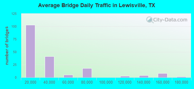
- 5,802,018Total average daily traffic
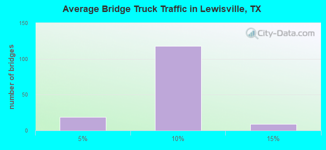
- 393,341Total average daily truck traffic
- National Bridge Inventory (NBI) Registered Bridges for Lewisville
- No street view available for this location
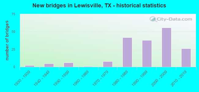
- New bridges - historical statistics
- 21930-1939
- 51940-1949
- 61950-1959
- 11960-1969
- 81970-1979
- 421980-1989
- 381990-1999
- 562000-2009
- 262010-2019
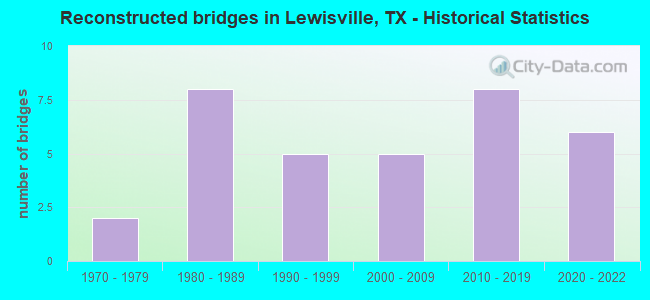
- Reconstructed bridges - Historical Statistics
- 21970-1979
- 81980-1989
- 51990-1999
- 52000-2009
- 82010-2019
- 62020-2022
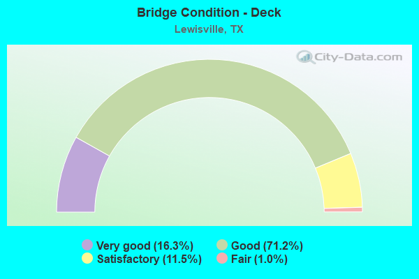
- Bridge Condition - Deck
- 16.3%Very good
- 71.2%Good
- 11.5%Satisfactory
- 1.0%Fair
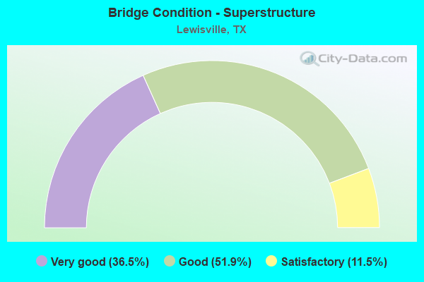
- Bridge Condition - Superstructure
- 36.5%Very good
- 51.9%Good
- 11.5%Satisfactory
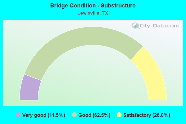
- Bridge Condition - Substructure
- 11.5%Very good
- 62.5%Good
- 26.0%Satisfactory
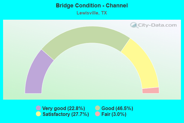
- Bridge Condition - Channel
- 22.8%Very good
- 46.5%Good
- 27.7%Satisfactory
- 3.0%Fair
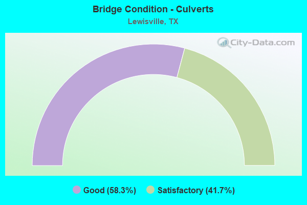
- Bridge Condition - Culverts
- 58.3%Good
- 41.7%Satisfactory
Find on map >> Show street view
Structure Number: 180570354702019, Location: 2.25 Mi SW of IH 35E (Lat: 32.986528, Lng: -96.992950), Route carried "on" structure: Other road 121, Year Built: 2006, Year Reconstructed: 2020, Status: Open, Structure Length: 8.75m (28.71ft), Average Daily Traffic: 20,000 (year 2016), Truck Traffic: 5%, Average Future Daily Traffic: 40,000 (year 2036), Design Load: HS 20, Features Intersected: Denton Tap Rd, Facility Carried by Structure: SRT SB
Minimum Vertical Clearance: 30+ m (98+ ft), Kilometerpoint: 19.489, Lanes on structure: 3, Lanes under structure: 8, Toll: On toll road, Owner: Local Toll Authority, Approaching Roadway Width: 14.0m (45.9ft), Skew: 9 degrees, Material/Design: Prestressed concrete, Design/Construction: Stringer/Multi-beam, Number Of Spans In Main Unit: 1, Number Of Approach Spans: 2, Length of Maximum Span: 38.7m (127.0ft), Curb-To-Curb Width: 13.9m (45.6ft), Out-to-Out Width: 17.7m (58.1ft)
Condition: Deck: Very good, Superstructure: Good, Substructure: Good, Operating Rating: 54.4 metric tons, Method Used To Determine Operating Rating: Assigned rating based on Load Factor Design (LFD) reported in metric tons, Inventory Rating: 32.7 metric tons, Method Used To Determine Inventory Rating: Assigned rating based on Load Factor Design (LFD) reported in metric tons, Structural Evaluation: Better than present minimum criteria, Deck Geometry: Meets minimum limits, Underclear: Meets minimum limits, Approach Roadway Alignment: Equal to present desirable criteria, Designated Inspection Frequency: Every 24 months, Inspection Date: June 2020, Deck Structure Type: Concrete Precast Panels
Find on map >> Show street view
Structure Number: 18057035470202, Location: 2.25 Mi SW of IH 35E (Lat: 32.986283, Lng: -96.992950), Route carried "on" structure: Other road 121, Year Built: 2006, Year Reconstructed: 2020, Status: Open, Structure Length: 8.75m (28.71ft), Average Daily Traffic: 20,000 (year 2016), Truck Traffic: 5%, Average Future Daily Traffic: 40,000 (year 2036), Design Load: HS 20, Features Intersected: Denton Tap Rd, Facility Carried by Structure: SRT NB
Minimum Vertical Clearance: 30+ m (98+ ft), Kilometerpoint: 19.489, Lanes on structure: 3, Lanes under structure: 8, Toll: On toll road, Owner: Local Toll Authority, Approaching Roadway Width: 14.3m (46.9ft), Skew: 9 degrees, Material/Design: Prestressed concrete, Design/Construction: Stringer/Multi-beam, Number Of Spans In Main Unit: 1, Number Of Approach Spans: 2, Length of Maximum Span: 38.7m (127.0ft), Curb-To-Curb Width: 14.1m (46.3ft), Out-to-Out Width: 17.7m (58.1ft)
Condition: Deck: Very good, Superstructure: Good, Substructure: Good, Operating Rating: 54.4 metric tons, Method Used To Determine Operating Rating: Assigned rating based on Load Factor Design (LFD) reported in metric tons, Inventory Rating: 32.7 metric tons, Method Used To Determine Inventory Rating: Assigned rating based on Load Factor Design (LFD) reported in metric tons, Structural Evaluation: Better than present minimum criteria, Deck Geometry: Meets minimum limits, Underclear: Meets minimum limits, Approach Roadway Alignment: Equal to present desirable criteria, Designated Inspection Frequency: Every 24 months, Inspection Date: June 2020, Deck Structure Type: Concrete Precast Panels
Find on map >> Show street view
Structure Number: 180570354702021, Location: 1.90 Mi SW of IH 35E (Lat: 32.986919, Lng: -96.985214), Route carried "on" structure: Other road 121, Year Built: 2006, Status: Open, Structure Length: 3.08m (10.10ft), Average Daily Traffic: 20,000 (year 2016), Truck Traffic: 5%, Average Future Daily Traffic: 40,000 (year 2036), Design Load: HS 20, Features Intersected: Draw, Facility Carried by Structure: SRT SB
Minimum Vertical Clearance: 30+ m (98+ ft), Kilometerpoint: 18.910, Lanes on structure: 4, Toll: On toll road, Owner: Local Toll Authority, Approaching Roadway Width: 16.0m (52.5ft), Skew: 9 degrees, Material/Design: Prestressed concrete, Design/Construction: Stringer/Multi-beam, Number Of Spans In Main Unit: 1, Length of Maximum Span: 30.8m (101.0ft), Curb-To-Curb Width: 16.0m (52.5ft), Out-to-Out Width: 21.3m (69.9ft)
Condition: Deck: Very good, Superstructure: Good, Substructure: Satisfactory, Channel: Very good, Operating Rating: 54.4 metric tons, Method Used To Determine Operating Rating: Assigned rating based on Load Factor Design (LFD) reported in metric tons, Inventory Rating: 32.7 metric tons, Method Used To Determine Inventory Rating: Assigned rating based on Load Factor Design (LFD) reported in metric tons, Structural Evaluation: Equal to present minimum criteria, Deck Geometry: High priority of replacement, Waterway Adequacy: Superior to present desirable criteria, Approach Roadway Alignment: Equal to present desirable criteria, Designated Inspection Frequency: Every 24 months, Inspection Date: May 2020, Deck Structure Type: Concrete Precast Panels
Find on map >> Show street view
Structure Number: 180570354702022, Location: 1.90 Mi SW of IH 35E (Lat: 32.986628, Lng: -96.985203), Route carried "on" structure: Other road 121, Year Built: 2006, Status: Open, Structure Length: 3.08m (10.10ft), Average Daily Traffic: 20,000 (year 2016), Truck Traffic: 5%, Average Future Daily Traffic: 40,000 (year 2036), Design Load: HS 20, Features Intersected: Draw, Facility Carried by Structure: SRT NB
Minimum Vertical Clearance: 30+ m (98+ ft), Kilometerpoint: 18.910, Lanes on structure: 4, Toll: On toll road, Owner: Local Toll Authority, Approaching Roadway Width: 14.0m (45.9ft), Skew: 9 degrees, Material/Design: Prestressed concrete, Design/Construction: Stringer/Multi-beam, Number Of Spans In Main Unit: 1, Length of Maximum Span: 30.8m (101.0ft), Curb-To-Curb Width: 14.0m (45.9ft), Out-to-Out Width: 21.3m (69.9ft)
Condition: Deck: Very good, Superstructure: Good, Substructure: Satisfactory, Channel: Good, Operating Rating: 54.4 metric tons, Method Used To Determine Operating Rating: Assigned rating based on Load Factor Design (LFD) reported in metric tons, Inventory Rating: 32.7 metric tons, Method Used To Determine Inventory Rating: Assigned rating based on Load Factor Design (LFD) reported in metric tons, Structural Evaluation: Equal to present minimum criteria, Deck Geometry: High priority of replacement, Waterway Adequacy: Superior to present desirable criteria, Approach Roadway Alignment: Equal to present desirable criteria, Designated Inspection Frequency: Every 24 months, Inspection Date: May 2020, Deck Structure Type: Concrete Precast Panels
Find on map >> Show street view
Structure Number: 180610019602023, Location: 2.60 MI NW OF DALLAS C/L (Lat: 33.010572, Lng: -96.977397), Route carried "on" structure: Interstate 35, Year Built: 1939, Year Reconstructed: 2016, Status: Open, Structure Length: 9.75m (31.99ft), Average Daily Traffic: 70,035 (year 2019), Truck Traffic: 7%, Average Future Daily Traffic: 107,150 (year 2033), Design Load: HS 20, Features Intersected: TIMBER CREEK
Minimum Vertical Clearance: 30+ m (98+ ft), Kilometerpoint: 5.835, Lanes on structure: 6, Owner: State Highway Agency, Approaching Roadway Width: 46.9m (153.9ft), Skew: 4 degrees, Material/Design: Steel, Design/Construction: Stringer/Multi-beam, Number Of Spans In Main Unit: 8, Length of Maximum Span: 12.2m (40.0ft), Curb-To-Curb Width: 46.9m (153.9ft), Out-to-Out Width: 47.9m (157.2ft)
Condition: Deck: Good, Superstructure: Good, Substructure: Satisfactory, Channel: Satisfactory, Operating Rating: 54.4 metric tons, Method Used To Determine Operating Rating: Assigned rating based on Load Factor Design (LFD) reported in metric tons, Inventory Rating: 32.7 metric tons, Method Used To Determine Inventory Rating: Assigned rating based on Load Factor Design (LFD) reported in metric tons, Structural Evaluation: Equal to present minimum criteria, Deck Geometry: Superior to present desirable criteria, Waterway Adequacy: Superior to present desirable criteria, Approach Roadway Alignment: Equal to present desirable criteria, Designated Inspection Frequency: Every 24 months, Inspection Date: November 2021, Deck Structure Type: Concrete Cast-file-Place, Wearing Surface/Protective System: Wearing Surface: Bituminous
Find on map >> Show street view
Structure Number: 180610019602026, Location: 0.65 MI NW OF DALLAS C/L (Lat: 32.993864, Lng: -96.948717), Route carried "on" structure: Interstate 35, Year Built: 1939, Year Reconstructed: 2007, Status: Open, Structure Length: 12.80m (41.99ft), Average Daily Traffic: 74,860 (year 2019), Truck Traffic: 7%, Average Future Daily Traffic: 107,150 (year 2033), Design Load: HS 20, Features Intersected: ELM FORK TRINITY RIVER
Minimum Vertical Clearance: 30+ m (98+ ft), Kilometerpoint: 2.583, Lanes on structure: 6, Owner: State Highway Agency, Approaching Roadway Width: 23.8m (78.1ft), Material/Design: Steel continuous, Design/Construction: Stringer/Multi-beam, Number Of Spans In Main Unit: 3, Number Of Approach Spans: 5, Length of Maximum Span: 22.9m (75.1ft), Curb-To-Curb Width: 23.8m (78.1ft), Out-to-Out Width: 24.1m (79.1ft)
Condition: Deck: Good, Superstructure: Good, Substructure: Good, Channel: Good, Operating Rating: 54.4 metric tons, Method Used To Determine Operating Rating: Assigned rating based on Load Factor Design (LFD) reported in metric tons, Inventory Rating: 32.7 metric tons, Method Used To Determine Inventory Rating: Assigned rating based on Load Factor Design (LFD) reported in metric tons, Structural Evaluation: Better than present minimum criteria, Deck Geometry: Meets minimum limits, Waterway Adequacy: Equal to present minimum criteria, Approach Roadway Alignment: Equal to present desirable criteria, Designated Inspection Frequency: Every 24 months, Inspection Date: October 2021, Deck Structure Type: Concrete Cast-file-Place, Wearing Surface/Protective System: Wearing Surface: Bituminous
Find on map >> Show street view
Structure Number: 180610019602052, Location: 2.20 MI N OF SH 121 BUS (Lat: 33.061664, Lng: -97.013658), Route carried "on" structure: Interstate 35, Year Built: 1953, Year Reconstructed: 1980, Status: Open, Structure Length: 1.77m (5.81ft), Average Daily Traffic: 114,891 (year 2020), Truck Traffic: 8%, Average Future Daily Traffic: 178,630 (year 2033), Design Load: HS 20, Features Intersected: DRAIN
Minimum Vertical Clearance: 30+ m (98+ ft), Kilometerpoint: 12.542, Lanes on structure: 13, Owner: State Highway Agency, Approaching Roadway Width: 55.5m (182.1ft), Skew: 3 degrees, Material/Design: Concrete, Design/Construction: Culvert, Number Of Spans In Main Unit: 5, Length of Maximum Span: 2.7m (8.9ft), Curb-To-Curb Width: 55.5m (182.1ft), Out-to-Out Width: 87.2m (286.1ft)
Condition: Channel: Very good, Culverts: Good, Operating Rating: 44.4 metric tons, Method Used To Determine Operating Rating: No rating analysis performed, Inventory Rating: 32.7 metric tons, Method Used To Determine Inventory Rating: No rating analysis performed, Structural Evaluation: Better than present minimum criteria, Deck Geometry: Superior to present desirable criteria, Waterway Adequacy: Equal to present minimum criteria, Approach Roadway Alignment: Equal to present desirable criteria, Designated Inspection Frequency: Every 24 months, Inspection Date: November 2021, Deck Structure Type: Concrete Cast-file-Place, Wearing Surface/Protective System: Wearing Surface: Bituminous
Find on map >> Show street view
Structure Number: 180610019602053, Location: 1.90 MI NW OF SH 121 (Lat: 33.052928, Lng: -97.010536), Route carried "on" structure: Interstate 35, Year Built: 1953, Year Reconstructed: 1975, Status: Open, Structure Length: 2.89m (9.48ft), Average Daily Traffic: 114,891 (year 2020), Truck Traffic: 8%, Average Future Daily Traffic: 178,630 (year 2033), Features Intersected: PRAIRIE CREEK
Minimum Vertical Clearance: 30+ m (98+ ft), Kilometerpoint: 11.536, Lanes on structure: 16, Owner: State Highway Agency, Approaching Roadway Width: 55.5m (182.1ft), Skew: 29 degrees, Material/Design: Concrete, Design/Construction: Culvert, Number Of Spans In Main Unit: 4, Length of Maximum Span: 2.4m (7.9ft), Curb-To-Curb Width: 18.0m (59.1ft), Out-to-Out Width: 85.3m (279.9ft)
Condition: Channel: Good, Culverts: Good, Operating Rating: 32.7 metric tons, Method Used To Determine Operating Rating: No rating analysis performed, Inventory Rating: 24.5 metric tons, Method Used To Determine Inventory Rating: No rating analysis performed, Structural Evaluation: Equal to present minimum criteria, Deck Geometry: High priority of replacement, Waterway Adequacy: Equal to present minimum criteria, Approach Roadway Alignment: Equal to present desirable criteria, Designated Inspection Frequency: Every 24 months, Inspection Date: October 2021, Deck Structure Type: Concrete Cast-file-Place, Wearing Surface/Protective System: Wearing Surface: Bituminous
Find on map >> Show street view
Structure Number: 180610019602056, Location: 1.45 MI NW OF SH 121 BUS (Lat: 33.046286, Lng: -97.008681), Route carried "on" structure: State highway 1171, Year Built: 1954, Year Reconstructed: 2017, Status: Open, Structure Length: 6.10m (20.01ft), Average Daily Traffic: 19,600 (year 2013), Truck Traffic: 13%, Average Future Daily Traffic: 28,000 (year 2033), Design Load: HS 20, Features Intersected: IH 35E
Minimum Vertical Clearance: 30+ m (98+ ft), Kilometerpoint: 0.042, Lanes on structure: 6, Lanes under structure: 10, Owner: State Highway Agency, Approaching Roadway Width: 23.2m (76.1ft), Skew: 21 degrees, Material/Design: Steel continuous, Design/Construction: Stringer/Multi-beam, Number Of Spans In Main Unit: 2, Number Of Approach Spans: 1, Length of Maximum Span: 25.0m (82.0ft), Curb or Sidewalk Widths: Left: 1.8m (5.9ft), Right: 1.8m (5.9ft), Curb-To-Curb Width: 19.5m (64.0ft), Out-to-Out Width: 23.7m (77.8ft)
Condition: Deck: Satisfactory, Superstructure: Good, Substructure: Good, Operating Rating: 54.4 metric tons, Method Used To Determine Operating Rating: Assigned rating based on Load Factor Design (LFD) reported in metric tons, Inventory Rating: 32.7 metric tons, Method Used To Determine Inventory Rating: Assigned rating based on Load Factor Design (LFD) reported in metric tons, Structural Evaluation: Better than present minimum criteria, Deck Geometry: High priority of replacement, Underclear: High priority of corrective action, Approach Roadway Alignment: Equal to present desirable criteria, Length Of Structure Improvement: 6.10m (20.01ft), Designated Inspection Frequency: Every 24 months, Inspection Date: October 2021, Bridge Improvement Cost: $26,000, Roadway Improvement Cost: $7,000, Total Project Cost: $33,000, Deck Structure Type: Concrete Cast-file-Place
Find on map >> Show street view
Structure Number: 180610019602079, Location: 2.60 MI NW OF DALLAS C/L (Lat: 33.010508, Lng: -96.976972), Route carried "on" structure: Interstate 35, Year Built: 1957, Year Reconstructed: 1983, Status: Open, Structure Length: 9.81m (32.19ft), Average Daily Traffic: 74,860 (year 2019), Truck Traffic: 8%, Average Future Daily Traffic: 103,920 (year 2030), Design Load: HS 20, Features Intersected: TIMBER CREEK
Minimum Vertical Clearance: 30+ m (98+ ft), Kilometerpoint: 5.834, Lanes on structure: 4, Owner: State Highway Agency, Approaching Roadway Width: 21.9m (71.9ft), Skew: 4 degrees, Material/Design: Steel, Design/Construction: Stringer/Multi-beam, Number Of Spans In Main Unit: 8, Length of Maximum Span: 12.2m (40.0ft), Curb-To-Curb Width: 21.6m (70.9ft), Out-to-Out Width: 22.3m (73.2ft)
Condition: Deck: Good, Superstructure: Good, Substructure: Satisfactory, Channel: Satisfactory, Operating Rating: 54.4 metric tons, Method Used To Determine Operating Rating: Assigned rating based on Load Factor Design (LFD) reported in metric tons, Inventory Rating: 32.7 metric tons, Method Used To Determine Inventory Rating: Assigned rating based on Load Factor Design (LFD) reported in metric tons, Structural Evaluation: Equal to present minimum criteria, Deck Geometry: Better than present minimum criteria, Waterway Adequacy: Superior to present desirable criteria, Approach Roadway Alignment: Equal to present desirable criteria, Designated Inspection Frequency: Every 24 months, Inspection Date: November 2021, Deck Structure Type: Concrete Cast-file-Place, Wearing Surface/Protective System: Wearing Surface: Bituminous
Find on map >> Show street view
Structure Number: 180610019602083, Location: 0.65 MI NW OF DALLAS C/L (Lat: 32.993625, Lng: -96.948703), Route carried "on" structure: Interstate 35, Year Built: 1957, Year Reconstructed: 2007, Status: Open, Structure Length: 12.41m (40.72ft), Average Daily Traffic: 70,035 (year 2019), Truck Traffic: 7%, Average Future Daily Traffic: 107,150 (year 2033), Design Load: HS 20, Features Intersected: ELM FORK TRINITY RIVER
Minimum Vertical Clearance: 30+ m (98+ ft), Kilometerpoint: 2.583, Lanes on structure: 4, Owner: State Highway Agency, Approaching Roadway Width: 22.6m (74.1ft), Material/Design: Steel continuous, Design/Construction: Stringer/Multi-beam, Number Of Spans In Main Unit: 3, Number Of Approach Spans: 7, Length of Maximum Span: 22.9m (75.1ft), Curb-To-Curb Width: 22.6m (74.1ft), Out-to-Out Width: 23.3m (76.4ft)
Condition: Deck: Satisfactory, Superstructure: Satisfactory, Substructure: Good, Channel: Good, Operating Rating: 42.6 metric tons, Method Used To Determine Operating Rating: Load Factor (LF), Inventory Rating: 25.4 metric tons, Method Used To Determine Inventory Rating: Load Factor (LF), Structural Evaluation: Equal to present minimum criteria, Deck Geometry: Superior to present desirable criteria, Waterway Adequacy: Equal to present minimum criteria, Approach Roadway Alignment: Equal to present desirable criteria, Designated Inspection Frequency: Every 24 months, Inspection Date: October 2021, Deck Structure Type: Concrete Cast-file-Place, Wearing Surface/Protective System: Wearing Surface: Bituminous
Find on map >> Show street view
Structure Number: 180610019602179, Location: 5.40 MI NW OF SH 121 BUS (Lat: 33.100225, Lng: -97.028114), Route carried "on" structure: Interstate 35, Year Built: 1972, Status: Open, Structure Length: 64.77m (212.50ft), Average Daily Traffic: 61,870 (year 2019), Truck Traffic: 10%, Average Future Daily Traffic: 95,230 (year 2033), Design Load: HS 20, Features Intersected: LEWISVILLE LAKE
Minimum Vertical Clearance: 30+ m (98+ ft), Kilometerpoint: 16.975, Lanes on structure: 4, Owner: State Highway Agency, Approaching Roadway Width: 16.8m (55.1ft), Material/Design: Prestressed concrete, Design/Construction: Stringer/Multi-beam, Number Of Spans In Main Unit: 25, Length of Maximum Span: 25.9m (85.0ft), Curb-To-Curb Width: 16.6m (54.5ft), Out-to-Out Width: 17.4m (57.1ft)
Condition: Deck: Satisfactory, Superstructure: Good, Substructure: Good, Channel: Satisfactory, Operating Rating: 68.0 metric tons, Method Used To Determine Operating Rating: Load Factor (LF), Inventory Rating: 28.1 metric tons, Method Used To Determine Inventory Rating: Load Factor (LF), Structural Evaluation: Better than present minimum criteria, Deck Geometry: Meets minimum limits, Waterway Adequacy: Superior to present desirable criteria, Approach Roadway Alignment: Equal to present desirable criteria, Designated Inspection Frequency: Every 24 months, Underwater Inspection Frequency: Every 60 months, Inspection Date: October 2021, Underwater Inspection Date: September 2016, Deck Structure Type: Concrete Cast-file-Place, Wearing Surface/Protective System: Wearing Surface: Bituminous
Find on map >> Show street view
Structure Number: 180610019602192, Location: 4.25 MI NW OF DALLAS C/L (Lat: 33.029950, Lng: -96.992158), Route carried "on" structure: ServiceOther road 35, Year Built: 1981, Status: Open, Structure Length: 12.31m (40.39ft), Average Daily Traffic: 14,460 (year 2013), Truck Traffic: 8%, Average Future Daily Traffic: 20,780 (year 2033), Design Load: HS 20, Features Intersected: SH 121 BUS
Minimum Vertical Clearance: 30+ m (98+ ft), Kilometerpoint: 8.423, Lanes on structure: 1, Lanes under structure: 9, Owner: State Highway Agency, Approaching Roadway Width: 12.2m (40.0ft), Skew: 4 degrees, Material/Design: Prestressed concrete, Design/Construction: Stringer/Multi-beam, Number Of Spans In Main Unit: 6, Length of Maximum Span: 22.6m (74.1ft), Curb-To-Curb Width: 12.2m (40.0ft), Out-to-Out Width: 12.8m (42.0ft)
Condition: Deck: Good, Superstructure: Satisfactory, Substructure: Good, Operating Rating: 54.4 metric tons, Method Used To Determine Operating Rating: Assigned rating based on Load Factor Design (LFD) reported in metric tons, Inventory Rating: 32.7 metric tons, Method Used To Determine Inventory Rating: Assigned rating based on Load Factor Design (LFD) reported in metric tons, Structural Evaluation: Equal to present minimum criteria, Deck Geometry: Somewhat better than minimum adequacy, Underclear: High priority of corrective action, Approach Roadway Alignment: Equal to present desirable criteria, Designated Inspection Frequency: Every 24 months, Inspection Date: October 2021, Deck Structure Type: Concrete Cast-file-Place
Find on map >> Show street view
Structure Number: 180610019602193, Location: 4.25 MI NW OF DALLAS C/L (Lat: 33.030164, Lng: -96.992711), Route carried "on" structure: Interstate 35, Year Built: 1981, Year Reconstructed: 2016, Status: Open, Structure Length: 12.62m (41.40ft), Average Daily Traffic: 74,860 (year 2019), Truck Traffic: 8%, Average Future Daily Traffic: 103,920 (year 2033), Design Load: HS 20, Features Intersected: SH 121 BUS
Minimum Vertical Clearance: 30+ m (98+ ft), Kilometerpoint: 8.455, Lanes on structure: 4, Lanes under structure: 10, Owner: State Highway Agency, Approaching Roadway Width: 16.7m (54.8ft), Skew: 4 degrees, Material/Design: Prestressed concrete, Design/Construction: Stringer/Multi-beam, Number Of Spans In Main Unit: 6, Length of Maximum Span: 22.9m (75.1ft), Curb-To-Curb Width: 16.7m (54.8ft), Out-to-Out Width: 19.0m (62.3ft)
Condition: Deck: Good, Superstructure: Good, Substructure: Good, Operating Rating: 54.4 metric tons, Method Used To Determine Operating Rating: Assigned rating based on Load Factor Design (LFD) reported in metric tons, Inventory Rating: 32.7 metric tons, Method Used To Determine Inventory Rating: Assigned rating based on Load Factor Design (LFD) reported in metric tons, Structural Evaluation: Better than present minimum criteria, Deck Geometry: Meets minimum limits, Underclear: High priority of corrective action, Approach Roadway Alignment: Equal to present desirable criteria, Designated Inspection Frequency: Every 24 months, Inspection Date: October 2021, Deck Structure Type: Concrete Cast-file-Place, Wearing Surface/Protective System: Wearing Surface: Bituminous
Find on map >> Show street view
Structure Number: 180610019602194, Location: 4.25 MI NW OF DALLAS C/L (Lat: 33.029900, Lng: -96.993197), Route carried "on" structure: ServiceOther road 35, Year Built: 1981, Status: Open, Structure Length: 12.31m (40.39ft), Average Daily Traffic: 14,460 (year 2013), Truck Traffic: 8%, Average Future Daily Traffic: 20,780 (year 2033), Design Load: HS 20, Features Intersected: SH 121 BUS
Minimum Vertical Clearance: 30+ m (98+ ft), Kilometerpoint: 8.423, Lanes on structure: 1, Lanes under structure: 9, Owner: State Highway Agency, Approaching Roadway Width: 12.2m (40.0ft), Skew: 4 degrees, Material/Design: Prestressed concrete, Design/Construction: Stringer/Multi-beam, Number Of Spans In Main Unit: 6, Length of Maximum Span: 22.6m (74.1ft), Curb-To-Curb Width: 12.2m (40.0ft), Out-to-Out Width: 12.8m (42.0ft)
Condition: Deck: Good, Superstructure: Good, Substructure: Good, Operating Rating: 54.4 metric tons, Method Used To Determine Operating Rating: Assigned rating based on Load Factor Design (LFD) reported in metric tons, Inventory Rating: 32.7 metric tons, Method Used To Determine Inventory Rating: Assigned rating based on Load Factor Design (LFD) reported in metric tons, Structural Evaluation: Better than present minimum criteria, Deck Geometry: Somewhat better than minimum adequacy, Underclear: High priority of corrective action, Approach Roadway Alignment: Equal to present desirable criteria, Designated Inspection Frequency: Every 24 months, Inspection Date: October 2021, Deck Structure Type: Concrete Cast-file-Place
Find on map >> Show street view
Structure Number: 180610019602212, Location: 3.20 MI NW OF DALLAS C/L (Lat: 33.017861, Lng: -96.983050), Route carried "on" structure: City street , Year Built: 1981, Year Reconstructed: 2017, Status: Open, Structure Length: 11.28m (37.01ft), Average Daily Traffic: 75,357 (year 2013), Average Future Daily Traffic: 75,357 (year 2033), Design Load: HS 20, Features Intersected: IH 35E, Facility Carried by Structure: CORPORATE DR
Minimum Vertical Clearance: 30+ m (98+ ft), Kilometerpoint: 0.805, Lanes on structure: 2, Lanes under structure: 14, Owner: State Highway Agency, Approaching Roadway Width: 9.8m (32.2ft), Material/Design: Prestressed concrete, Design/Construction: Stringer/Multi-beam, Number Of Spans In Main Unit: 2, Number Of Approach Spans: 5, Length of Maximum Span: 19.4m (63.6ft), Curb-To-Curb Width: 10.4m (34.1ft), Out-to-Out Width: 11.0m (36.1ft)
Condition: Deck: Satisfactory, Superstructure: Good, Substructure: Good, Operating Rating: 54.4 metric tons, Method Used To Determine Operating Rating: Assigned rating based on Load Factor Design (LFD) reported in metric tons, Inventory Rating: 32.7 metric tons, Method Used To Determine Inventory Rating: Assigned rating based on Load Factor Design (LFD) reported in metric tons, Structural Evaluation: Better than present minimum criteria, Deck Geometry: Meets minimum limits, Underclear: High priority of corrective action, Approach Roadway Alignment: Equal to present desirable criteria, Designated Inspection Frequency: Every 24 months, Inspection Date: October 2021, Deck Structure Type: Concrete Cast-file-Place
Find on map >> Show street view
Structure Number: 180610019602213, Location: 4.25 MI NW OF DALLAS C/L (Lat: 33.030097, Lng: -96.992947), Route carried "on" structure: Interstate 35, Year Built: 1981, Year Reconstructed: 2016, Status: Open, Structure Length: 12.62m (41.40ft), Average Daily Traffic: 76,761 (year 2019), Truck Traffic: 8%, Average Future Daily Traffic: 103,920 (year 2033), Design Load: HS 20, Features Intersected: SH 121 BUS
Minimum Vertical Clearance: 30+ m (98+ ft), Kilometerpoint: 8.455, Lanes on structure: 5, Lanes under structure: 10, Owner: State Highway Agency, Approaching Roadway Width: 16.7m (54.8ft), Skew: 4 degrees, Material/Design: Prestressed concrete, Design/Construction: Stringer/Multi-beam, Number Of Spans In Main Unit: 6, Length of Maximum Span: 22.9m (75.1ft), Curb-To-Curb Width: 16.7m (54.8ft), Out-to-Out Width: 22.2m (72.8ft)
Condition: Deck: Good, Superstructure: Good, Substructure: Good, Operating Rating: 54.4 metric tons, Method Used To Determine Operating Rating: Assigned rating based on Load Factor Design (LFD) reported in metric tons, Inventory Rating: 32.7 metric tons, Method Used To Determine Inventory Rating: Assigned rating based on Load Factor Design (LFD) reported in metric tons, Structural Evaluation: Better than present minimum criteria, Deck Geometry: High priority of replacement, Underclear: High priority of corrective action, Approach Roadway Alignment: Equal to present desirable criteria, Designated Inspection Frequency: Every 24 months, Inspection Date: October 2021, Deck Structure Type: Concrete Cast-file-Place, Wearing Surface/Protective System: Wearing Surface: Bituminous
Find on map >> Show street view
Structure Number: 180610019602224, Location: 1.10 MI NW OF DALLAS C/L (Lat: 32.996567, Lng: -96.955003), Route carried "on" structure: ServiceOther road 35, Year Built: 1982, Status: Open, Structure Length: 12.19m (39.99ft), Average Daily Traffic: 14,460 (year 2013), Truck Traffic: 8%, Average Future Daily Traffic: 20,780 (year 2033), Design Load: HS 20, Features Intersected: TIMBER CREEK
Minimum Vertical Clearance: 30+ m (98+ ft), Kilometerpoint: 3.323, Lanes on structure: 2, Owner: State Highway Agency, Approaching Roadway Width: 9.8m (32.2ft), Skew: 1 degrees, Material/Design: Prestressed concrete, Design/Construction: Stringer/Multi-beam, Number Of Spans In Main Unit: 5, Length of Maximum Span: 24.4m (80.1ft), Curb-To-Curb Width: 10.2m (33.5ft), Out-to-Out Width: 10.8m (35.4ft)
Condition: Deck: Satisfactory, Superstructure: Good, Substructure: Good, Channel: Satisfactory, Operating Rating: 54.4 metric tons, Method Used To Determine Operating Rating: Assigned rating based on Load Factor Design (LFD) reported in metric tons, Inventory Rating: 32.7 metric tons, Method Used To Determine Inventory Rating: Assigned rating based on Load Factor Design (LFD) reported in metric tons, Structural Evaluation: Better than present minimum criteria, Deck Geometry: Meets minimum limits, Waterway Adequacy: Better than present minimum criteria, Approach Roadway Alignment: Equal to present desirable criteria, Designated Inspection Frequency: Every 24 months, Inspection Date: October 2021, Deck Structure Type: Concrete Cast-file-Place
Find on map >> Show street view
Structure Number: 180610019602248, Location: 2.60 MI NW OF DALLAS C/L (Lat: 33.010686, Lng: -96.976753), Route carried "on" structure: ServiceOther road 35, Year Built: 1983, Status: Open, Structure Length: 9.75m (31.99ft), Average Daily Traffic: 14,460 (year 2013), Truck Traffic: 8%, Average Future Daily Traffic: 20,780 (year 2033), Design Load: HS 20, Features Intersected: TIMBER CREEK
Minimum Vertical Clearance: 30+ m (98+ ft), Kilometerpoint: 5.789, Lanes on structure: 2, Owner: State Highway Agency, Approaching Roadway Width: 9.8m (32.2ft), Skew: 4 degrees, Material/Design: Prestressed concrete, Design/Construction: Stringer/Multi-beam, Number Of Spans In Main Unit: 4, Length of Maximum Span: 24.4m (80.1ft), Curb-To-Curb Width: 10.1m (33.1ft), Out-to-Out Width: 11.0m (36.1ft)
Condition: Deck: Good, Superstructure: Good, Substructure: Satisfactory, Channel: Satisfactory, Operating Rating: 54.4 metric tons, Method Used To Determine Operating Rating: Assigned rating based on Load Factor Design (LFD) reported in metric tons, Inventory Rating: 32.7 metric tons, Method Used To Determine Inventory Rating: Assigned rating based on Load Factor Design (LFD) reported in metric tons, Structural Evaluation: Equal to present minimum criteria, Deck Geometry: Somewhat better than minimum adequacy, Waterway Adequacy: Equal to present minimum criteria, Approach Roadway Alignment: Equal to present desirable criteria, Designated Inspection Frequency: Every 24 months, Inspection Date: October 2021, Deck Structure Type: Concrete Cast-file-Place
Find on map >> Show street view
Structure Number: 180610019602249, Location: 2.60 MI NW OF DALLAS C/L (Lat: 33.010589, Lng: -96.978022), Route carried "on" structure: ServiceOther road 35, Year Built: 1983, Status: Open, Structure Length: 9.75m (31.99ft), Average Daily Traffic: 6,450 (year 2013), Truck Traffic: 7%, Average Future Daily Traffic: 9,030 (year 2033), Design Load: HS 20, Features Intersected: TIMBER CREEK
Minimum Vertical Clearance: 30+ m (98+ ft), Kilometerpoint: 5.903, Lanes on structure: 2, Owner: State Highway Agency, Approaching Roadway Width: 9.8m (32.2ft), Skew: 4 degrees, Material/Design: Prestressed concrete, Design/Construction: Stringer/Multi-beam, Number Of Spans In Main Unit: 4, Length of Maximum Span: 24.4m (80.1ft), Curb-To-Curb Width: 10.1m (33.1ft), Out-to-Out Width: 11.0m (36.1ft)
Condition: Deck: Good, Superstructure: Good, Substructure: Satisfactory, Channel: Satisfactory, Operating Rating: 54.4 metric tons, Method Used To Determine Operating Rating: Assigned rating based on Load Factor Design (LFD) reported in metric tons, Inventory Rating: 32.7 metric tons, Method Used To Determine Inventory Rating: Assigned rating based on Load Factor Design (LFD) reported in metric tons, Structural Evaluation: Equal to present minimum criteria, Deck Geometry: Somewhat better than minimum adequacy, Waterway Adequacy: Better than present minimum criteria, Approach Roadway Alignment: Equal to present desirable criteria, Designated Inspection Frequency: Every 24 months, Inspection Date: October 2021, Deck Structure Type: Concrete Cast-file-Place
Find on map >> Show street view
Structure Number: 18061001960225, Location: 2.90 MI NW OF DALLAS C/L (Lat: 33.014772, Lng: -96.980564), Route carried "on" structure: Interstate 35, Year Built: 1983, Status: Open, Structure Length: 18.29m (60.01ft), Average Daily Traffic: 74,860 (year 2019), Truck Traffic: 7%, Average Future Daily Traffic: 107,150 (year 2033), Design Load: HS 20, Features Intersected: TIMBER CREEK RELIEF
Minimum Vertical Clearance: 30+ m (98+ ft), Kilometerpoint: 6.328, Lanes on structure: 4, Owner: State Highway Agency, Approaching Roadway Width: 18.0m (59.1ft), Skew: 3 degrees, Material/Design: Prestressed concrete, Design/Construction: Stringer/Multi-beam, Number Of Spans In Main Unit: 8, Length of Maximum Span: 22.9m (75.1ft), Curb-To-Curb Width: 18.2m (59.7ft), Out-to-Out Width: 19.0m (62.3ft)
Condition: Deck: Good, Superstructure: Good, Substructure: Good, Channel: Good, Operating Rating: 54.4 metric tons, Method Used To Determine Operating Rating: Assigned rating based on Load Factor Design (LFD) reported in metric tons, Inventory Rating: 32.7 metric tons, Method Used To Determine Inventory Rating: Assigned rating based on Load Factor Design (LFD) reported in metric tons, Structural Evaluation: Better than present minimum criteria, Deck Geometry: Meets minimum limits, Waterway Adequacy: Equal to present minimum criteria, Approach Roadway Alignment: Equal to present desirable criteria, Designated Inspection Frequency: Every 24 months, Inspection Date: October 2021, Deck Structure Type: Concrete Cast-file-Place, Wearing Surface/Protective System: Wearing Surface: Bituminous
Find on map >> Show street view
Structure Number: 180610019602251, Location: 2.90 MI NW OF DALLAS C/L (Lat: 33.014408, Lng: -96.980594), Route carried "on" structure: Interstate 35, Year Built: 1983, Year Reconstructed: 2015, Status: Open, Structure Length: 18.29m (60.01ft), Average Daily Traffic: 70,035 (year 2019), Truck Traffic: 7%, Average Future Daily Traffic: 107,150 (year 2033), Design Load: HS 20, Features Intersected: TIMBER CREEK RELIEF
Minimum Vertical Clearance: 30+ m (98+ ft), Kilometerpoint: 6.328, Lanes on structure: 7, Owner: State Highway Agency, Approaching Roadway Width: 19.2m (63.0ft), Skew: 3 degrees, Material/Design: Prestressed concrete, Design/Construction: Stringer/Multi-beam, Number Of Spans In Main Unit: 8, Length of Maximum Span: 22.9m (75.1ft), Curb-To-Curb Width: 28.8m (94.5ft), Out-to-Out Width: 32.8m (107.6ft)
Condition: Deck: Good, Superstructure: Good, Substructure: Good, Channel: Good, Operating Rating: 54.4 metric tons, Method Used To Determine Operating Rating: Assigned rating based on Load Factor Design (LFD) reported in metric tons, Inventory Rating: 32.7 metric tons, Method Used To Determine Inventory Rating: Assigned rating based on Load Factor Design (LFD) reported in metric tons, Structural Evaluation: Better than present minimum criteria, Deck Geometry: Meets minimum limits, Waterway Adequacy: Equal to present desirable criteria, Approach Roadway Alignment: Equal to present desirable criteria, Designated Inspection Frequency: Every 24 months, Inspection Date: October 2021, Deck Structure Type: Concrete Cast-file-Place, Wearing Surface/Protective System: Wearing Surface: Bituminous
Find on map >> Show street view
Structure Number: 180610019602252, Location: 2.90 MI NW OF DALLAS C/L (Lat: 33.015119, Lng: -96.980314), Route carried "on" structure: ServiceOther road 35, Year Built: 1983, Status: Open, Structure Length: 18.29m (60.01ft), Average Daily Traffic: 5,470 (year 2013), Truck Traffic: 7%, Average Future Daily Traffic: 7,660 (year 2033), Design Load: HS 20, Features Intersected: TIMBER CREEK RELIEF
Minimum Vertical Clearance: 30+ m (98+ ft), Kilometerpoint: 6.278, Lanes on structure: 2, Owner: State Highway Agency, Approaching Roadway Width: 9.8m (32.2ft), Skew: 3 degrees, Material/Design: Prestressed concrete, Design/Construction: Stringer/Multi-beam, Number Of Spans In Main Unit: 8, Length of Maximum Span: 22.9m (75.1ft), Curb-To-Curb Width: 10.1m (33.1ft), Out-to-Out Width: 11.0m (36.1ft)
Condition: Deck: Good, Superstructure: Good, Substructure: Satisfactory, Channel: Good, Operating Rating: 54.4 metric tons, Method Used To Determine Operating Rating: Assigned rating based on Load Factor Design (LFD) reported in metric tons, Inventory Rating: 32.7 metric tons, Method Used To Determine Inventory Rating: Assigned rating based on Load Factor Design (LFD) reported in metric tons, Structural Evaluation: Equal to present minimum criteria, Deck Geometry: Somewhat better than minimum adequacy, Waterway Adequacy: Better than present minimum criteria, Approach Roadway Alignment: Equal to present desirable criteria, Designated Inspection Frequency: Every 24 months, Inspection Date: October 2021, Deck Structure Type: Concrete Cast-file-Place
Find on map >> Show street view
Structure Number: 180610019602253, Location: 2.90 MI NW OF DALLAS C/L (Lat: 33.014061, Lng: -96.980708), Route carried "on" structure: ServiceOther road 35, Year Built: 1983, Status: Open, Structure Length: 18.29m (60.01ft), Average Daily Traffic: 6,450 (year 2013), Truck Traffic: 7%, Average Future Daily Traffic: 9,030 (year 2033), Design Load: HS 20, Features Intersected: TIMBER CREEK RELIEF
Minimum Vertical Clearance: 30+ m (98+ ft), Kilometerpoint: 6.359, Lanes on structure: 2, Owner: State Highway Agency, Approaching Roadway Width: 9.8m (32.2ft), Skew: 3 degrees, Material/Design: Prestressed concrete, Design/Construction: Stringer/Multi-beam, Number Of Spans In Main Unit: 8, Length of Maximum Span: 22.9m (75.1ft), Curb-To-Curb Width: 10.1m (33.1ft), Out-to-Out Width: 11.0m (36.1ft)
Condition: Deck: Good, Superstructure: Good, Substructure: Good, Channel: Good, Operating Rating: 54.4 metric tons, Method Used To Determine Operating Rating: Assigned rating based on Load Factor Design (LFD) reported in metric tons, Inventory Rating: 32.7 metric tons, Method Used To Determine Inventory Rating: Assigned rating based on Load Factor Design (LFD) reported in metric tons, Structural Evaluation: Better than present minimum criteria, Deck Geometry: Somewhat better than minimum adequacy, Waterway Adequacy: Better than present minimum criteria, Approach Roadway Alignment: Equal to present desirable criteria, Designated Inspection Frequency: Every 24 months, Inspection Date: October 2021, Deck Structure Type: Concrete Cast-file-Place
Find on map >> Show street view
Structure Number: 180610019602262, Location: 2.20 MI NW OF SH 121 BUS (Lat: 33.056053, Lng: -97.012397), Route carried "on" structure: City street , Year Built: 1990, Status: Open, Structure Length: 14.02m (46.00ft), Average Daily Traffic: 6,000 (year 2014), Average Future Daily Traffic: 8,000 (year 2034), Design Load: HS 20, Features Intersected: IH 35E, Facility Carried by Structure: VALLEY RIDGE BL WB
Minimum Vertical Clearance: 30+ m (98+ ft), Kilometerpoint: 0.805, Lanes on structure: 2, Lanes under structure: 17, Owner: State Highway Agency, Approaching Roadway Width: 8.5m (27.9ft), Skew: 1 degrees, Material/Design: Prestressed concrete, Design/Construction: Stringer/Multi-beam, Number Of Spans In Main Unit: 4, Length of Maximum Span: 36.6m (120.1ft), Curb or Sidewalk Widths: Left: 0.0m, Right: 1.7m (5.6ft), Curb-To-Curb Width: 8.5m (27.9ft), Out-to-Out Width: 10.8m (35.4ft)
Condition: Deck: Satisfactory, Superstructure: Satisfactory, Substructure: Satisfactory, Operating Rating: 54.4 metric tons, Method Used To Determine Operating Rating: Assigned rating based on Load Factor Design (LFD) reported in metric tons, Inventory Rating: 32.7 metric tons, Method Used To Determine Inventory Rating: Assigned rating based on Load Factor Design (LFD) reported in metric tons, Structural Evaluation: Equal to present minimum criteria, Deck Geometry: High priority of corrective action, Underclear: High priority of corrective action, Approach Roadway Alignment: Equal to present desirable criteria, Length Of Structure Improvement: 14.02m (46.00ft), Designated Inspection Frequency: Every 24 months, Inspection Date: October 2021, Bridge Improvement Cost: $26,000, Roadway Improvement Cost: $7,000, Total Project Cost: $33,000, Deck Structure Type: Concrete Precast Panels
Find on map >> Show street view
Structure Number: 180610019602263, Location: 2.20 MI NW OF SH 121 BUS (Lat: 33.055900, Lng: -97.011186), Route carried "on" structure: City street , Year Built: 1990, Status: Open, Structure Length: 14.02m (46.00ft), Average Daily Traffic: 6,000 (year 2014), Average Future Daily Traffic: 8,000 (year 2034), Design Load: HS 20, Features Intersected: IH 35E, Facility Carried by Structure: VALLEY RIDGE BL EB
Minimum Vertical Clearance: 30+ m (98+ ft), Kilometerpoint: 0.805, Lanes on structure: 2, Lanes under structure: 17, Owner: State Highway Agency, Approaching Roadway Width: 8.5m (27.9ft), Skew: 1 degrees, Material/Design: Prestressed concrete, Design/Construction: Stringer/Multi-beam, Number Of Spans In Main Unit: 4, Length of Maximum Span: 36.6m (120.1ft), Curb or Sidewalk Widths: Left: 0.0m, Right: 1.6m (5.2ft), Curb-To-Curb Width: 8.5m (27.9ft), Out-to-Out Width: 10.8m (35.4ft)
Condition: Deck: Satisfactory, Superstructure: Satisfactory, Substructure: Satisfactory, Operating Rating: 54.4 metric tons, Method Used To Determine Operating Rating: Assigned rating based on Load Factor Design (LFD) reported in metric tons, Inventory Rating: 32.7 metric tons, Method Used To Determine Inventory Rating: Assigned rating based on Load Factor Design (LFD) reported in metric tons, Structural Evaluation: Equal to present minimum criteria, Deck Geometry: High priority of corrective action, Underclear: High priority of corrective action, Approach Roadway Alignment: Equal to present desirable criteria, Length Of Structure Improvement: 14.02m (46.00ft), Designated Inspection Frequency: Every 24 months, Inspection Date: October 2021, Bridge Improvement Cost: $26,000, Roadway Improvement Cost: $7,000, Total Project Cost: $33,000, Deck Structure Type: Concrete Precast Panels
Find on map >> Show street view
Structure Number: 180610019602289, Location: 1.10 MI NW OF DALLAS C/L (Lat: 32.997208, Lng: -96.954742), Route carried "on" structure: Interstate 35, Year Built: 1996, Year Reconstructed: 2006, Status: Open, Structure Length: 12.19m (39.99ft), Average Daily Traffic: 70,035 (year 2019), Truck Traffic: 7%, Average Future Daily Traffic: 107,150 (year 2033), Design Load: HS 20, Features Intersected: TIMBER CREEK
Minimum Vertical Clearance: 30+ m (98+ ft), Kilometerpoint: 3.323, Lanes on structure: 7, Owner: State Highway Agency, Approaching Roadway Width: 16.8m (55.1ft), Skew: 1 degrees, Material/Design: Prestressed concrete, Design/Construction: Stringer/Multi-beam, Number Of Spans In Main Unit: 5, Length of Maximum Span: 24.4m (80.1ft), Curb-To-Curb Width: 28.7m (94.2ft), Out-to-Out Width: 35.6m (116.8ft)
Condition: Deck: Good, Superstructure: Good, Substructure: Good, Channel: Satisfactory, Operating Rating: 54.4 metric tons, Method Used To Determine Operating Rating: Assigned rating based on Load Factor Design (LFD) reported in metric tons, Inventory Rating: 32.7 metric tons, Method Used To Determine Inventory Rating: Assigned rating based on Load Factor Design (LFD) reported in metric tons, Structural Evaluation: Better than present minimum criteria, Deck Geometry: Meets minimum limits, Waterway Adequacy: Superior to present desirable criteria, Approach Roadway Alignment: Equal to present desirable criteria, Designated Inspection Frequency: Every 24 months, Inspection Date: October 2021, Deck Structure Type: Concrete Precast Panels
Find on map >> Show street view
Structure Number: 18061001960229, Location: 1.10 MI NW OF DALLAS C/L (Lat: 32.997503, Lng: -96.954608), Route carried "on" structure: Interstate 35, Year Built: 1996, Year Reconstructed: 2006, Status: Open, Structure Length: 12.19m (39.99ft), Average Daily Traffic: 74,860 (year 2019), Truck Traffic: 7%, Average Future Daily Traffic: 107,150 (year 2033), Design Load: HS 20, Features Intersected: TIMBER CREEK
Minimum Vertical Clearance: 30+ m (98+ ft), Kilometerpoint: 3.325, Lanes on structure: 6, Owner: State Highway Agency, Approaching Roadway Width: 24.4m (80.1ft), Skew: 1 degrees, Material/Design: Prestressed concrete, Design/Construction: Stringer/Multi-beam, Number Of Spans In Main Unit: 5, Length of Maximum Span: 24.4m (80.1ft), Curb-To-Curb Width: 24.4m (80.1ft), Out-to-Out Width: 31.1m (102.0ft)
Condition: Deck: Good, Superstructure: Very good, Substructure: Good, Channel: Good, Operating Rating: 54.4 metric tons, Method Used To Determine Operating Rating: Assigned rating based on Load Factor Design (LFD) reported in metric tons, Inventory Rating: 32.7 metric tons, Method Used To Determine Inventory Rating: Assigned rating based on Load Factor Design (LFD) reported in metric tons, Structural Evaluation: Better than present minimum criteria, Deck Geometry: Meets minimum limits, Waterway Adequacy: Superior to present desirable criteria, Approach Roadway Alignment: Equal to present desirable criteria, Designated Inspection Frequency: Every 24 months, Inspection Date: October 2021, Deck Structure Type: Concrete Precast Panels
Find on map >> Show street view
Structure Number: 180610019602292, Location: 1.39 MI NW OF DALLAS C/L (Lat: 33.000342, Lng: -96.959272), Route carried "on" structure: ServiceOther road 121, Year Built: 1995, Status: Open, Structure Length: 6.64m (21.78ft), Average Daily Traffic: 10,000 (year 2013), Truck Traffic: 5%, Average Future Daily Traffic: 12,000 (year 2033), Design Load: HS 20, Features Intersected: IH 35E
Minimum Vertical Clearance: 30+ m (98+ ft), Kilometerpoint: 3.476, Lanes on structure: 3, Lanes under structure: 8, Owner: State Highway Agency, Approaching Roadway Width: 12.2m (40.0ft), Skew: 1 degrees, Material/Design: Prestressed concrete, Design/Construction: Stringer/Multi-beam, Number Of Spans In Main Unit: 2, Length of Maximum Span: 33.2m (108.9ft), Curb or Sidewalk Widths: Left: 1.8m (5.9ft), Right: 0.0m, Curb-To-Curb Width: 12.2m (40.0ft), Out-to-Out Width: 14.6m (47.9ft)
Condition: Deck: Good, Superstructure: Good, Substructure: Good, Operating Rating: 54.4 metric tons, Method Used To Determine Operating Rating: Assigned rating based on Load Factor Design (LFD) reported in metric tons, Inventory Rating: 32.7 metric tons, Method Used To Determine Inventory Rating: Assigned rating based on Load Factor Design (LFD) reported in metric tons, Structural Evaluation: Better than present minimum criteria, Deck Geometry: Meets minimum limits, Underclear: High priority of corrective action, Approach Roadway Alignment: Equal to present desirable criteria, Length Of Structure Improvement: 6.64m (21.78ft), Designated Inspection Frequency: Every 24 months, Inspection Date: October 2021, Bridge Improvement Cost: $17,000, Roadway Improvement Cost: $4,000, Total Project Cost: $21,000, Deck Structure Type: Concrete Precast Panels
Find on map >> Show street view
Structure Number: 180610019602293, Location: 1.32 MI NW OF DALLAS C/L (Lat: 32.999333, Lng: -96.958803), Route carried "on" structure: ServiceState highway 121, Year Built: 1995, Status: Open, Structure Length: 6.64m (21.78ft), Average Daily Traffic: 10,000 (year 2013), Truck Traffic: 5%, Average Future Daily Traffic: 12,000 (year 2033), Design Load: HS 20, Features Intersected: IH 35E
Minimum Vertical Clearance: 30+ m (98+ ft), Kilometerpoint: 3.476, Lanes on structure: 3, Lanes under structure: 8, Owner: State Highway Agency, Approaching Roadway Width: 12.2m (40.0ft), Skew: 1 degrees, Material/Design: Prestressed concrete, Design/Construction: Stringer/Multi-beam, Number Of Spans In Main Unit: 2, Length of Maximum Span: 33.2m (108.9ft), Curb or Sidewalk Widths: Left: 0.0m, Right: 1.8m (5.9ft), Curb-To-Curb Width: 12.2m (40.0ft), Out-to-Out Width: 14.6m (47.9ft)
Condition: Deck: Good, Superstructure: Good, Substructure: Good, Operating Rating: 54.4 metric tons, Method Used To Determine Operating Rating: Assigned rating based on Load Factor Design (LFD) reported in metric tons, Inventory Rating: 32.7 metric tons, Method Used To Determine Inventory Rating: Assigned rating based on Load Factor Design (LFD) reported in metric tons, Structural Evaluation: Better than present minimum criteria, Deck Geometry: Meets minimum limits, Underclear: High priority of corrective action, Approach Roadway Alignment: Equal to present desirable criteria, Length Of Structure Improvement: 6.64m (21.78ft), Designated Inspection Frequency: Every 24 months, Inspection Date: October 2021, Bridge Improvement Cost: $17,000, Roadway Improvement Cost: $4,000, Total Project Cost: $21,000, Deck Structure Type: Concrete Precast Panels
Find on map >> Show street view
Structure Number: 180610019602306, Location: 0.30 MI SE OF SH 121 (Lat: 32.995897, Lng: -96.951692), Route carried "on" structure: Interstate 35, Year Built: 2006, Status: Open, Structure Length: 7.32m (24.02ft), Average Daily Traffic: 74,860 (year 2019), Truck Traffic: 7%, Average Future Daily Traffic: 107,150 (year 2033), Design Load: HS 20, Features Intersected: ELM FK TRINITY RIV REL 3
Minimum Vertical Clearance: 30+ m (98+ ft), Kilometerpoint: 3.018, Lanes on structure: 5, Owner: State Highway Agency, Approaching Roadway Width: 24.4m (80.1ft), Material/Design: Prestressed concrete, Design/Construction: Stringer/Multi-beam, Number Of Spans In Main Unit: 3, Length of Maximum Span: 25.9m (85.0ft), Curb-To-Curb Width: 24.4m (80.1ft), Out-to-Out Width: 32.0m (105.0ft)
Condition: Deck: Good, Superstructure: Very good, Substructure: Good, Channel: Very good, Operating Rating: 54.4 metric tons, Method Used To Determine Operating Rating: Assigned rating based on Load Factor Design (LFD) reported in metric tons, Inventory Rating: 32.7 metric tons, Method Used To Determine Inventory Rating: Assigned rating based on Load Factor Design (LFD) reported in metric tons, Structural Evaluation: Better than present minimum criteria, Deck Geometry: Equal to present minimum criteria, Waterway Adequacy: Superior to present desirable criteria, Approach Roadway Alignment: Equal to present desirable criteria, Designated Inspection Frequency: Every 24 months, Inspection Date: October 2021, Deck Structure Type: Concrete Precast Panels
Find on map >> Show street view
Structure Number: 180610019602307, Location: 0.30 MI SE OF SH 121 (Lat: 32.995622, Lng: -96.951906), Route carried "on" structure: Interstate 35, Year Built: 2006, Status: Open, Structure Length: 7.32m (24.02ft), Average Daily Traffic: 70,035 (year 2019), Truck Traffic: 7%, Average Future Daily Traffic: 107,150 (year 2033), Design Load: HS 20, Features Intersected: ELM FK TRINITY RIV REL 3
Minimum Vertical Clearance: 30+ m (98+ ft), Kilometerpoint: 3.018, Lanes on structure: 5, Owner: State Highway Agency, Approaching Roadway Width: 33.5m (109.9ft), Material/Design: Prestressed concrete, Design/Construction: Stringer/Multi-beam, Number Of Spans In Main Unit: 3, Length of Maximum Span: 25.9m (85.0ft), Curb-To-Curb Width: 33.5m (109.9ft), Out-to-Out Width: 36.9m (121.1ft)
Condition: Deck: Good, Superstructure: Very good, Substructure: Good, Channel: Very good, Operating Rating: 54.4 metric tons, Method Used To Determine Operating Rating: Assigned rating based on Load Factor Design (LFD) reported in metric tons, Inventory Rating: 32.7 metric tons, Method Used To Determine Inventory Rating: Assigned rating based on Load Factor Design (LFD) reported in metric tons, Structural Evaluation: Better than present minimum criteria, Deck Geometry: Superior to present desirable criteria, Waterway Adequacy: Superior to present desirable criteria, Approach Roadway Alignment: Equal to present desirable criteria, Designated Inspection Frequency: Every 24 months, Inspection Date: October 2021, Deck Structure Type: Concrete Precast Panels
Find on map >> Show street view
Structure Number: 180610019602308, Location: 1.10 MI NW OF DALLAS C/L (Lat: 32.997553, Lng: -96.954586), Route carried "on" structure: Ramp Other road 35, Year Built: 2006, Status: Open, Structure Length: 4.88m (16.01ft), Average Daily Traffic: 15,300 (year 2013), Truck Traffic: 7%, Average Future Daily Traffic: 21,430 (year 2033), Design Load: HS 20, Features Intersected: TIMBER CREEK
Minimum Vertical Clearance: 30+ m (98+ ft), Kilometerpoint: 3.336, Lanes on structure: 1, Owner: State Highway Agency, Approaching Roadway Width: 7.9m (25.9ft), Skew: 2 degrees, Material/Design: Prestressed concrete, Design/Construction: Stringer/Multi-beam, Number Of Spans In Main Unit: 2, Length of Maximum Span: 24.4m (80.1ft), Curb-To-Curb Width: 7.7m (25.3ft), Out-to-Out Width: 8.5m (27.9ft)
Condition: Deck: Very good, Superstructure: Good, Substructure: Very good, Channel: Good, Operating Rating: 54.4 metric tons, Method Used To Determine Operating Rating: Assigned rating based on Load Factor Design (LFD) reported in metric tons, Inventory Rating: 32.7 metric tons, Method Used To Determine Inventory Rating: Assigned rating based on Load Factor Design (LFD) reported in metric tons, Structural Evaluation: Better than present minimum criteria, Deck Geometry: Better than present minimum criteria, Waterway Adequacy: Superior to present desirable criteria, Approach Roadway Alignment: Equal to present desirable criteria, Designated Inspection Frequency: Every 24 months, Inspection Date: October 2021, Deck Structure Type: Concrete Precast Panels
Find on map >> Show street view
Structure Number: 18061001960231, Location: 0.3 MI SE OF SH 121 (Lat: 32.995997, Lng: -96.951608), Route carried "on" structure: Ramp Interstate 35, Year Built: 2006, Status: Open, Structure Length: 2.59m (8.50ft), Average Daily Traffic: 15,300 (year 2013), Truck Traffic: 7%, Average Future Daily Traffic: 21,430 (year 2033), Design Load: HS 20, Features Intersected: ELM FK TRINITY RIV REL 3
Minimum Vertical Clearance: 30+ m (98+ ft), Kilometerpoint: 3.328, Lanes on structure: 2, Owner: State Highway Agency, Approaching Roadway Width: 11.0m (36.1ft), Material/Design: Prestressed concrete, Design/Construction: Stringer/Multi-beam, Number Of Spans In Main Unit: 1, Length of Maximum Span: 25.9m (85.0ft), Curb-To-Curb Width: 11.0m (36.1ft), Out-to-Out Width: 11.6m (38.1ft)
Condition: Deck: Very good, Superstructure: Very good, Substructure: Very good, Channel: Good, Operating Rating: 54.4 metric tons, Method Used To Determine Operating Rating: Assigned rating based on Load Factor Design (LFD) reported in metric tons, Inventory Rating: 32.7 metric tons, Method Used To Determine Inventory Rating: Assigned rating based on Load Factor Design (LFD) reported in metric tons, Structural Evaluation: Equal to present desirable criteria, Deck Geometry: Better than present minimum criteria, Waterway Adequacy: Superior to present desirable criteria, Approach Roadway Alignment: Equal to present desirable criteria, Designated Inspection Frequency: Every 24 months, Inspection Date: October 2021, Deck Structure Type: Concrete Precast Panels
Find on map >> Show street view
Structure Number: 180610019602312, Location: 0.30 MI SE OF SH 121 (Lat: 32.995347, Lng: -96.952119), Route carried "on" structure: ServiceOther road 35, Year Built: 2006, Status: Open, Structure Length: 12.62m (41.40ft), Average Daily Traffic: 6,450 (year 2013), Truck Traffic: 7%, Average Future Daily Traffic: 9,030 (year 2033), Design Load: HS 20, Features Intersected: ELM FK TRINITY RIV REL 3
Minimum Vertical Clearance: 30+ m (98+ ft), Kilometerpoint: 3.018, Lanes on structure: 2, Owner: State Highway Agency, Approaching Roadway Width: 11.6m (38.1ft), Skew: 9 degrees, Material/Design: Prestressed concrete, Design/Construction: Stringer/Multi-beam, Number Of Spans In Main Unit: 5, Length of Maximum Span: 26.2m (86.0ft), Curb-To-Curb Width: 11.6m (38.1ft), Out-to-Out Width: 12.2m (40.0ft)
Condition: Deck: Very good, Superstructure: Very good, Substructure: Good, Channel: Good, Operating Rating: 54.4 metric tons, Method Used To Determine Operating Rating: Assigned rating based on Load Factor Design (LFD) reported in metric tons, Inventory Rating: 32.7 metric tons, Method Used To Determine Inventory Rating: Assigned rating based on Load Factor Design (LFD) reported in metric tons, Structural Evaluation: Better than present minimum criteria, Deck Geometry: Better than present minimum criteria, Waterway Adequacy: Superior to present desirable criteria, Approach Roadway Alignment: Equal to present desirable criteria, Designated Inspection Frequency: Every 24 months, Inspection Date: October 2021, Deck Structure Type: Concrete Precast Panels
Find on map >> Show street view
Structure Number: 18061001960232, Location: 2.25 MI NW OF DALLAS C/L (Lat: 33.006889, Lng: -96.972200), Route carried "on" structure: State highway 3040, Year Built: 1989, Status: Open, Structure Length: 9.78m (32.09ft), Average Daily Traffic: 35,030 (year 2013), Truck Traffic: 3%, Average Future Daily Traffic: 49,040 (year 2033), Design Load: HS 20, Features Intersected: IH 35E
Minimum Vertical Clearance: 30+ m (98+ ft), Kilometerpoint: 21.712, Lanes on structure: 7, Lanes under structure: 8, Owner: State Highway Agency, Approaching Roadway Width: 28.0m (91.9ft), Skew: 20 degrees, Material/Design: Prestressed concrete, Design/Construction: Stringer/Multi-beam, Number Of Spans In Main Unit: 2, Number Of Approach Spans: 1, Length of Maximum Span: 40.5m (132.9ft), Curb or Sidewalk Widths: Left: 1.8m (5.9ft), Right: 1.8m (5.9ft), Curb-To-Curb Width: 27.2m (89.2ft), Out-to-Out Width: 32.3m (106.0ft)
Condition: Deck: Good, Superstructure: Good, Substructure: Satisfactory, Operating Rating: 54.4 metric tons, Method Used To Determine Operating Rating: Assigned rating based on Load Factor Design (LFD) reported in metric tons, Inventory Rating: 32.7 metric tons, Method Used To Determine Inventory Rating: Assigned rating based on Load Factor Design (LFD) reported in metric tons, Structural Evaluation: Equal to present minimum criteria, Deck Geometry: Somewhat better than minimum adequacy, Underclear: High priority of corrective action, Approach Roadway Alignment: Equal to present desirable criteria, Designated Inspection Frequency: Every 24 months, Inspection Date: October 2021, Deck Structure Type: Concrete Cast-file-Place
Find on map >> Show street view
Structure Number: 180610019602372, Location: IH35E/SH121 INTERCHANGE (Lat: 32.995342, Lng: -96.965017), Route carried "on" structure: Other road 121, Year Built: 2006, Status: Open, Structure Length: 115.15m (377.79ft), Average Daily Traffic: 62,000 (year 2013), Truck Traffic: 6%, Average Future Daily Traffic: 80,000 (year 2033), Design Load: HS 20, Features Intersected: IH35E L VISTA DR TIMB CR
Minimum Vertical Clearance: 6.25m (20.51ft), Kilometerpoint: 16.190, Lanes on structure: 3, Lanes under structure: 21, Toll: On toll road, Owner: Local Toll Authority, Approaching Roadway Width: 17.1m (56.1ft), Skew: 9 degrees, Material/Design: Prestressed concrete, Design/Construction: Stringer/Multi-beam, Number Of Spans In Main Unit: 31, Number Of Approach Spans: 5, Length of Maximum Span: 40.2m (131.9ft), Curb-To-Curb Width: 17.1m (56.1ft), Out-to-Out Width: 18.7m (61.4ft)
Condition: Deck: Good, Superstructure: Very good, Substructure: Good, Channel: Very good, Operating Rating: 54.4 metric tons, Method Used To Determine Operating Rating: Assigned rating based on Load Factor Design (LFD) reported in metric tons, Inventory Rating: 32.7 metric tons, Method Used To Determine Inventory Rating: Assigned rating based on Load Factor Design (LFD) reported in metric tons, Structural Evaluation: Better than present minimum criteria, Deck Geometry: Superior to present desirable criteria, Underclear: Meets minimum limits, Waterway Adequacy: Superior to present desirable criteria, Approach Roadway Alignment: Equal to present desirable criteria, Designated Inspection Frequency: Every 24 months, Inspection Date: October 2021, Deck Structure Type: Concrete Precast Panels
Find on map >> Show street view
Structure Number: 180610019602373, Location: IH35E SH121 INTERCHANGE (Lat: 32.995150, Lng: -96.964797), Route carried "on" structure: Other road 121, Year Built: 2006, Status: Open, Structure Length: 118.54m (388.91ft), Average Daily Traffic: 62,000 (year 2013), Truck Traffic: 6%, Average Future Daily Traffic: 80,000 (year 2033), Design Load: HS 20, Features Intersected: IH35E L VISTA DR TIMB CR
Minimum Vertical Clearance: 6.71m (22.01ft), Kilometerpoint: 16.158, Lanes on structure: 3, Lanes under structure: 21, Toll: On toll road, Owner: Local Toll Authority, Approaching Roadway Width: 17.1m (56.1ft), Skew: 9 degrees, Material/Design: Prestressed concrete, Design/Construction: Stringer/Multi-beam, Number Of Spans In Main Unit: 32, Number Of Approach Spans: 5, Length of Maximum Span: 40.2m (131.9ft), Curb-To-Curb Width: 17.1m (56.1ft), Out-to-Out Width: 18.9m (62.0ft)
Condition: Deck: Good, Superstructure: Good, Substructure: Good, Channel: Very good, Operating Rating: 54.4 metric tons, Method Used To Determine Operating Rating: Assigned rating based on Load Factor Design (LFD) reported in metric tons, Inventory Rating: 32.7 metric tons, Method Used To Determine Inventory Rating: Assigned rating based on Load Factor Design (LFD) reported in metric tons, Structural Evaluation: Better than present minimum criteria, Deck Geometry: Superior to present desirable criteria, Underclear: High priority of corrective action, Waterway Adequacy: Superior to present desirable criteria, Approach Roadway Alignment: Equal to present desirable criteria, Designated Inspection Frequency: Every 24 months, Inspection Date: October 2021, Deck Structure Type: Concrete Precast Panels
Find on map >> Show street view
Structure Number: 180610019602375, Location: IH 35E/SH121 INTERCHANGE (Lat: 32.998283, Lng: -96.955664), Route carried "on" structure: Other road 35, Year Built: 2006, Status: Open, Structure Length: 88.82m (291.40ft), Average Daily Traffic: 10,000 (year 2010), Truck Traffic: 6%, Average Future Daily Traffic: 18,100 (year 2030), Design Load: HS 20, Features Intersected: W-S CONN/SH 121, Facility Carried by Structure: CONNECTOR N-W
Minimum Vertical Clearance: 30+ m (98+ ft), Kilometerpoint: 76.153, Lanes on structure: 1, Lanes under structure: 18, Toll: On toll road, Owner: Local Toll Authority, Approaching Roadway Width: 7.9m (25.9ft), Material/Design: Steel continuous, Design/Construction: Stringer/Multi-beam, Number Of Spans In Main Unit: 4, Number Of Approach Spans: 18, Length of Maximum Span: 75.6m (248.0ft), Curb-To-Curb Width: 7.7m (25.3ft), Out-to-Out Width: 8.5m (27.9ft)
Condition: Deck: Good, Superstructure: Very good, Substructure: Good, Operating Rating: 54.4 metric tons, Method Used To Determine Operating Rating: Assigned rating based on Load Factor Design (LFD) reported in metric tons, Inventory Rating: 32.7 metric tons, Method Used To Determine Inventory Rating: Assigned rating based on Load Factor Design (LFD) reported in metric tons, Structural Evaluation: Better than present minimum criteria, Deck Geometry: High priority of replacement, Underclear: High priority of corrective action, Approach Roadway Alignment: Equal to present desirable criteria, Designated Inspection Frequency: Every 24 months, Inspection Date: November 2021, Deck Structure Type: Concrete Cast-file-Place, Wearing Surface/Protective System: Deck Protection: Epoxy Coated Reinforcing
Find on map >> Show street view
Structure Number: 180610019602376, Location: IH 35E/SH121 INTERCHANGE (Lat: 32.997822, Lng: -96.961275), Route carried "on" structure: Other road 35, Year Built: 2006, Status: Open, Structure Length: 39.75m (130.41ft), Average Daily Traffic: 10,000 (year 2010), Truck Traffic: 6%, Average Future Daily Traffic: 18,100 (year 2028), Design Load: HS 20, Features Intersected: IH 35E SBFR/SH 121 NBFR, Facility Carried by Structure: CONNECTOR E-S
Minimum Vertical Clearance: 6.10m (20.01ft), Kilometerpoint: 23.717, Lanes on structure: 1, Lanes under structure: 6, Toll: On toll road, Owner: Local Toll Authority, Approaching Roadway Width: 7.9m (25.9ft), Skew: 9 degrees, Material/Design: Steel continuous, Design/Construction: Stringer/Multi-beam, Number Of Spans In Main Unit: 4, Number Of Approach Spans: 5, Length of Maximum Span: 66.8m (219.2ft), Curb-To-Curb Width: 7.7m (25.3ft), Out-to-Out Width: 8.5m (27.9ft)
Condition: Deck: Good, Superstructure: Very good, Substructure: Good, Operating Rating: 54.4 metric tons, Method Used To Determine Operating Rating: Assigned rating based on Load Factor Design (LFD) reported in metric tons, Inventory Rating: 32.7 metric tons, Method Used To Determine Inventory Rating: Assigned rating based on Load Factor Design (LFD) reported in metric tons, Structural Evaluation: Better than present minimum criteria, Deck Geometry: High priority of replacement, Underclear: Equal to present minimum criteria, Approach Roadway Alignment: Equal to present desirable criteria, Designated Inspection Frequency: Every 24 months, Inspection Date: November 2021, Deck Structure Type: Concrete Cast-file-Place, Wearing Surface/Protective System: Deck Protection: Epoxy Coated Reinforcing