Bridge Statistics for Leominster, Massachusetts (MA)
Condition, Traffic, Stress, Structural Evaluation, Project Costs
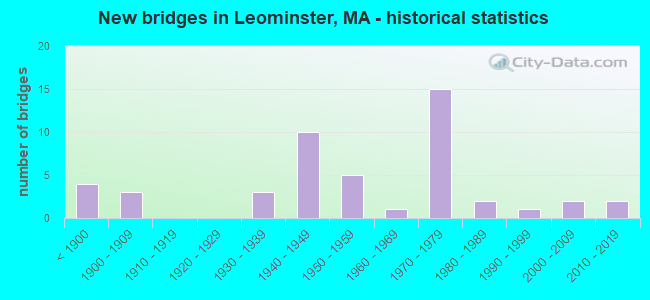
- New bridges - historical statistics
- 4Before 1900
- 31900-1909
- 31930-1939
- 101940-1949
- 51950-1959
- 11960-1969
- 151970-1979
- 21980-1989
- 11990-1999
- 22000-2009
- 22010-2019
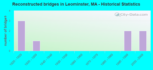
- Reconstructed bridges - Historical Statistics
- 31920-1929
- 11930-1939
- 01940-1949
- 01950-1959
- 01960-1969
- 01970-1979
- 01980-1989
- 21990-1999
- 22000-2009
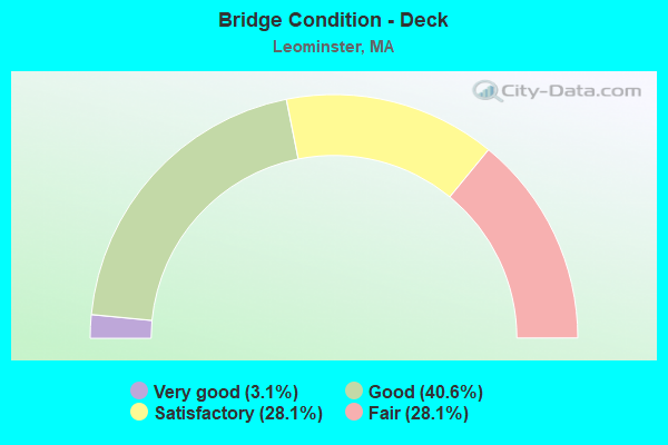
- Bridge Condition - Deck
- 3.1%Very good
- 40.6%Good
- 28.1%Satisfactory
- 28.1%Fair
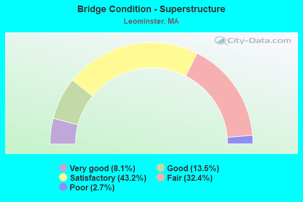
- Bridge Condition - Superstructure
- 8.1%Very good
- 13.5%Good
- 43.2%Satisfactory
- 32.4%Fair
- 2.7%Poor
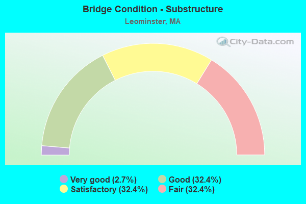
- Bridge Condition - Substructure
- 2.7%Very good
- 32.4%Good
- 32.4%Satisfactory
- 32.4%Fair
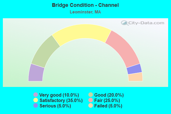
- Bridge Condition - Channel
- 10.0%Very good
- 20.0%Good
- 35.0%Satisfactory
- 25.0%Fair
- 5.0%Serious
- 5.0%Failed
Find on map >> Show street view
Structure Number: L080471NWDOTNBI, Location: .5 MILES S.E. OF ST 13 (Lat: 42.529383, Lng: -71.734122), Route carried "on" structure: State highway 2, Year Built: 1975, Status: Open, Structure Length: 4.42m (14.50ft), Average Daily Traffic: 34,120 (year 2019), Truck Traffic: 6%, Average Future Daily Traffic: 78,965 (year 2032), Design Load: HS 20+Mod, Features Intersected: HWY NASHUA ST
Minimum Vertical Clearance: 30+ m (98+ ft), Kilometerpoint: 162.861, Lanes on structure: 3, Lanes under structure: 2, Base Highway Network: Yes, Owner: State Highway Agency, Approaching Roadway Width: 25.9m (85.0ft), Skew: 1 degrees, Material/Design: Steel, Design/Construction: Stringer/Multi-beam, Number Of Spans In Main Unit: 1, Length of Maximum Span: 42.4m (139.1ft), Curb or Sidewalk Widths: Left: 0.2m (0.7ft), Right: 0.2m (0.7ft), Curb-To-Curb Width: 25.6m (84.0ft), Out-to-Out Width: 27.0m (88.6ft)
Condition: Deck: Satisfactory, Superstructure: Satisfactory, Substructure: Fair, Operating Rating: 58.5 metric tons, Method Used To Determine Operating Rating: Load Factor (LF), Inventory Rating: 35.0 metric tons, Method Used To Determine Inventory Rating: Load Factor (LF), Structural Evaluation: Somewhat better than minimum adequacy, Deck Geometry: Superior to present desirable criteria, Underclear: Meets minimum limits, Approach Roadway Alignment: Equal to present desirable criteria, Length Of Structure Improvement: 4.50m (14.76ft), Designated Inspection Frequency: Every 24 months, Inspection Date: April 2021, Bridge Improvement Cost: $4,773,000, Roadway Improvement Cost: $478,000, Total Project Cost: $7,160,000 ( Estimate for 2022), Deck Structure Type: Concrete Cast-file-Place, Wearing Surface/Protective System: Wearing Surface: Bituminous, Membrane: Built-up
Find on map >> Show street view
Structure Number: L17010571DOT634, Location: JUST WEST OF FORT POND RD (Lat: 42.536556, Lng: -71.702231), Route carried "on" structure: City street , Year Built: 2007, Status: Open, Structure Length: 5.31m (17.42ft), Average Daily Traffic: 9,356 (year 2019), Truck Traffic: 5%, Average Future Daily Traffic: 10,265 (year 2031), Design Load: HS 20, Features Intersected: RR MBTA/BMRR, Facility Carried by Structure: HWY SHIRLEY ST
Minimum Vertical Clearance: 30+ m (98+ ft), Kilometerpoint: 0.000, Lanes on structure: 2, Owner: State Highway Agency, Approaching Roadway Width: 10.0m (32.8ft), Skew: 3 degrees, Material/Design: Steel continuous, Design/Construction: Stringer/Multi-beam, Number Of Spans In Main Unit: 3, Length of Maximum Span: 20.0m (65.6ft), Curb or Sidewalk Widths: Left: 0.0m, Right: 1.7m (5.6ft), Curb-To-Curb Width: 10.0m (32.8ft), Out-to-Out Width: 12.5m (41.0ft)
Condition: Deck: Good, Superstructure: Very good, Substructure: Good, Inventory Rating: 67.7 metric tons, Method Used To Determine Inventory Rating: Load Factor (LF), Structural Evaluation: Better than present minimum criteria, Deck Geometry: Meets minimum limits, Underclear: Equal to present minimum criteria, Approach Roadway Alignment: Better than present minimum criteria, Length Of Structure Improvement: 5.40m (17.72ft), Designated Inspection Frequency: Every 24 months, Inspection Date: November 2020, Bridge Improvement Cost: $1,732,000, Roadway Improvement Cost: $174,000, Total Project Cost: $2,599,000 ( Estimate for 2022), Deck Structure Type: Concrete Cast-file-Place, Wearing Surface/Protective System: Wearing Surface: Bituminous, Membrane: Preformed Fabric, Deck Protection: Epoxy Coated Reinforcing
Find on map >> Show street view
Structure Number: L080241KEDOTNBI, Location: NORTH MAIN ST/ ST 2 (Lat: 42.550000, Lng: -71.766667), Route carried "under" structure: State highway 2, Year Built: 1949, Structure Length: 0. m, Average Daily Traffic: 16,000 (year 0000), Features Intersected: ST 2 EB
Minimum Vertical Clearance: 4.32m (14.17ft), Kilometerpoint: 0.000, Lanes on structure: 2, Lanes under structure: 4, Material/Design: Steel continuous, Design/Construction: Stringer/Multi-beam, Length of Maximum Span: 20.7m (67.9ft)
Find on map >> Show street view
Structure Number: L080241KEDOTNBI, Location: NORTH MAIN ST/ ST 2 (Lat: 42.550000, Lng: -71.766667), Route carried "under" structure: State highway 2, Year Built: 1949, Structure Length: 0. m, Average Daily Traffic: 16,000 (year 0000), Features Intersected: ST 2 WB
Minimum Vertical Clearance: 4.32m (14.17ft), Kilometerpoint: 0.000, Lanes on structure: 2, Lanes under structure: 4, Material/Design: Steel continuous, Design/Construction: Stringer/Multi-beam, Length of Maximum Span: 20.7m (67.9ft)
Find on map >> Show street view
Structure Number: L0802620VDOTNBI, Location: MERRIAM AVE/ ST 2 (Lat: 42.550000, Lng: -71.783333), Route carried "under" structure: State highway 2, Year Built: 1947, Structure Length: 0. m, Average Daily Traffic: 3,510 (year 0000), Features Intersected: ST 2 EB, Facility Carried by Structure: HWY MERRIAM AVE
Minimum Vertical Clearance: 30+ m (98+ ft), Kilometerpoint: 0.000, Lanes on structure: 2, Lanes under structure: 4, Material/Design: Steel continuous, Design/Construction: Stringer/Multi-beam, Length of Maximum Span: 15.2m (49.9ft)
Find on map >> Show street view
Structure Number: L0802620VDOTNBI, Location: MERRIAM AVE/ ST 2 (Lat: 42.550000, Lng: -71.783333), Route carried "under" structure: State highway 2, Year Built: 1947, Structure Length: 0. m, Average Daily Traffic: 16,000 (year 0000), Features Intersected: ST 2 WB, Facility Carried by Structure: HWY MERRIAM AVE
Minimum Vertical Clearance: 4.27m (14.01ft), Kilometerpoint: 0.000, Lanes on structure: 2, Lanes under structure: 2, Material/Design: Steel continuous, Design/Construction: Stringer/Multi-beam, Length of Maximum Span: 15.2m (49.9ft)
Find on map >> Show street view
Structure Number: L0802820WDOTNBI, Location: HAMILTON ST/ ST 2 (Lat: 42.550000, Lng: -71.750000), Route carried "under" structure: State highway 2, Year Built: 1949, Structure Length: 0. m, Average Daily Traffic: 16,000 (year 0000), Features Intersected: ST 2 WB, Facility Carried by Structure: HWY HAMILTON ST
Minimum Vertical Clearance: 4.27m (14.01ft), Kilometerpoint: 0.000, Lanes on structure: 2, Lanes under structure: 2, Material/Design: Steel continuous, Design/Construction: Stringer/Multi-beam, Length of Maximum Span: 30.5m (100.1ft)
Find on map >> Show street view
Structure Number: L0802820WDOTNBI, Location: HAMILTON ST/ ST 2 (Lat: 42.550000, Lng: -71.750000), Route carried "under" structure: State highway 2, Year Built: 1949, Structure Length: 0. m, Average Daily Traffic: 16,000 (year 0000), Features Intersected: ST 2 EB, Facility Carried by Structure: HWY HAMILTON ST
Minimum Vertical Clearance: 4.27m (14.01ft), Kilometerpoint: 0.000, Lanes on structure: 2, Lanes under structure: 2, Material/Design: Steel continuous, Design/Construction: Stringer/Multi-beam, Length of Maximum Span: 30.5m (100.1ft)
Find on map >> Show street view
Structure Number: L080301LLDOTNBI, Location: ST 13 MAIN ST/ ST 2 (Lat: 42.533333, Lng: -71.750000), Route carried "under" structure: State highway 2, Year Built: 1953, Structure Length: 0. m, Average Daily Traffic: 13,810 (year 0000), Features Intersected: ST 2 WB, Facility Carried by Structure: ST 13 MAIN ST
Minimum Vertical Clearance: 4.27m (14.01ft), Kilometerpoint: 0.000, Lanes on structure: 2, Lanes under structure: 2, Material/Design: Steel, Design/Construction: Stringer/Multi-beam, Length of Maximum Span: 14.3m (46.9ft)
Find on map >> Show street view
Structure Number: L080301LLDOTNBI, Location: ST 13 MAIN ST/ ST 2 (Lat: 42.533333, Lng: -71.750000), Route carried "under" structure: State highway 2, Year Built: 1953, Structure Length: 0. m, Average Daily Traffic: 16,000 (year 0000), Features Intersected: ST 2 EB, Facility Carried by Structure: ST 13 MAIN ST
Minimum Vertical Clearance: 4.27m (14.01ft), Kilometerpoint: 0.000, Lanes on structure: 2, Lanes under structure: 2, Material/Design: Steel, Design/Construction: Stringer/Multi-beam, Length of Maximum Span: 14.3m (46.9ft)
Find on map >> Show street view
Structure Number: L080451W1DOTNBI, Location: I-190 NB/ST 2 EB (Lat: 42.516667, Lng: -71.733333), Route carried "under" structure: State highway 2, Year Built: 1975, Structure Length: 0. m, Average Daily Traffic: 8,000 (year 0000), Features Intersected: ST 2 EB, Facility Carried by Structure: I 190 NB
Minimum Vertical Clearance: 30+ m (98+ ft), Kilometerpoint: 0.000, Lanes on structure: 2, Lanes under structure: 2, Material/Design: Steel, Design/Construction: Stringer/Multi-beam, Length of Maximum Span: 48.8m (160.1ft)