Bridge Statistics for Leominster, Massachusetts (MA)
Condition, Traffic, Stress, Structural Evaluation, Project Costs
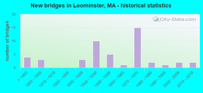
- New bridges - historical statistics
- 4Before 1900
- 31900-1909
- 31930-1939
- 101940-1949
- 51950-1959
- 11960-1969
- 151970-1979
- 21980-1989
- 11990-1999
- 22000-2009
- 22010-2019
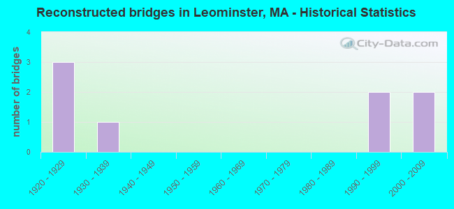
- Reconstructed bridges - Historical Statistics
- 31920-1929
- 11930-1939
- 01940-1949
- 01950-1959
- 01960-1969
- 01970-1979
- 01980-1989
- 21990-1999
- 22000-2009
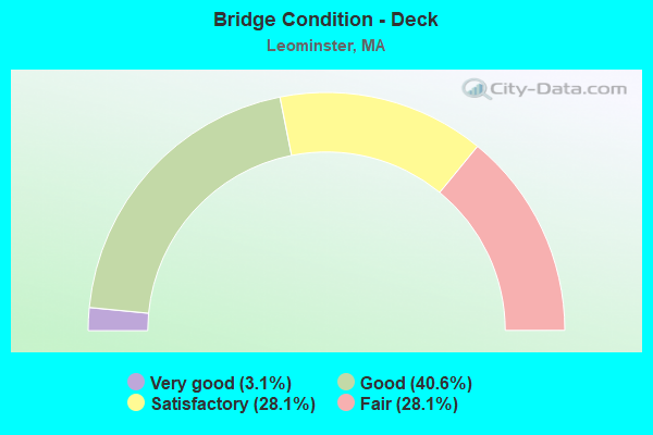
- Bridge Condition - Deck
- 3.1%Very good
- 40.6%Good
- 28.1%Satisfactory
- 28.1%Fair
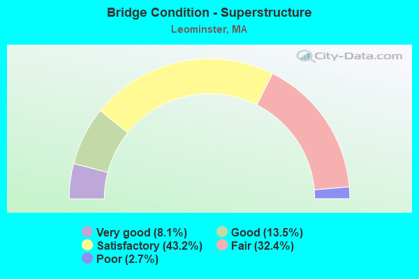
- Bridge Condition - Superstructure
- 8.1%Very good
- 13.5%Good
- 43.2%Satisfactory
- 32.4%Fair
- 2.7%Poor
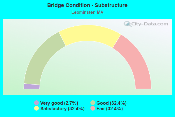
- Bridge Condition - Substructure
- 2.7%Very good
- 32.4%Good
- 32.4%Satisfactory
- 32.4%Fair
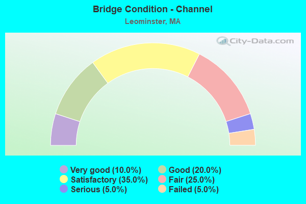
- Bridge Condition - Channel
- 10.0%Very good
- 20.0%Good
- 35.0%Satisfactory
- 25.0%Fair
- 5.0%Serious
- 5.0%Failed
Find on map >> Show street view
Structure Number: B270024UKMBTNBI, Location: OVER GREEN LINE (Lat: 42.337733, Lng: -71.141983), Route carried "on" structure: City street , Year Built: 1850, Year Reconstructed: 1932, Status: Open, Structure Length: 1.98m (6.50ft), Average Daily Traffic: 3,000 (year 1997), Truck Traffic: 5%, Average Future Daily Traffic: 4,738 (year 2030), Design Load: H 20, Features Intersected: TR GREEN LINE D, Facility Carried by Structure: HWY DEAN RD
Minimum Vertical Clearance: 30+ m (98+ ft), Kilometerpoint: 0.000, Lanes on structure: 2, Owner: State Agenciy, Maintenance Responsibility: State Highway Agency, Approaching Roadway Width: 9.1m (29.9ft), Skew: 1 degrees, Material/Design: Steel, Design/Construction: Stringer/Multi-beam, Number Of Spans In Main Unit: 1, Length of Maximum Span: 18.3m (60.0ft), Curb or Sidewalk Widths: Left: 3.1m (10.2ft), Right: 3.1m (10.2ft), Curb-To-Curb Width: 9.1m (29.9ft), Out-to-Out Width: 16.1m (52.8ft)
Condition: Deck: Good, Superstructure: Good, Substructure: Good, Operating Rating: 57.2 metric tons, Method Used To Determine Operating Rating: Allowable Stress (AS), Inventory Rating: 27.1 metric tons, Method Used To Determine Inventory Rating: Allowable Stress (AS), Structural Evaluation: Equal to present minimum criteria, Deck Geometry: Meets minimum limits, Underclear: High priority of corrective action, Approach Roadway Alignment: Better than present minimum criteria, Length Of Structure Improvement: 2.00m (6.56ft), Designated Inspection Frequency: Every 24 months, Inspection Date: March 2021, Bridge Improvement Cost: $1,265,000, Roadway Improvement Cost: $127,000, Total Project Cost: $1,898,000 ( Estimate for 2022), Deck Structure Type: Concrete Cast-file-Place, Wearing Surface/Protective System: Wearing Surface: Bituminous
Find on map >> Show street view
Structure Number: B270054UNMBTNBI, Location: OVER GREEN LINE (Lat: 42.331908, Lng: -71.118250), Route carried "on" structure: City street , Year Built: 1884, Year Reconstructed: 1927, Status: Open, Structure Length: 0.98m (3.22ft), Average Daily Traffic: 24,300 (year 2012), Truck Traffic: 4%, Average Future Daily Traffic: 22,268 (year 2032), Design Load: H 20, Features Intersected: TR GREEN LINE D, Facility Carried by Structure: HWY WASHNGTON ST
Minimum Vertical Clearance: 30+ m (98+ ft), Kilometerpoint: 0.000, Lanes on structure: 5, Base Highway Network: Yes, Owner: State Agenciy, Maintenance Responsibility: State Highway Agency, Approaching Roadway Width: 21.0m (68.9ft), Skew: 20 degrees, Material/Design: Steel, Design/Construction: Stringer/Multi-beam, Number Of Spans In Main Unit: 1, Length of Maximum Span: 8.2m (26.9ft), Curb or Sidewalk Widths: Left: 3.7m (12.1ft), Right: 3.9m (12.8ft), Curb-To-Curb Width: 20.1m (65.9ft), Out-to-Out Width: 27.5m (90.2ft)
Condition: Deck: Fair, Superstructure: Fair, Substructure: Satisfactory, Channel: Failed, Operating Rating: 46.2 metric tons, Method Used To Determine Operating Rating: Load Factor (LF), Inventory Rating: 27.7 metric tons, Method Used To Determine Inventory Rating: Load Factor (LF), Structural Evaluation: Somewhat better than minimum adequacy, Deck Geometry: Somewhat better than minimum adequacy, Underclear: High priority of corrective action, Approach Roadway Alignment: Equal to present minimum criteria, Length Of Structure Improvement: 1.00m (3.28ft), Designated Inspection Frequency: Every 24 months, Inspection Date: Febuary 2020, Bridge Improvement Cost: $1,081,000, Roadway Improvement Cost: $109,000, Total Project Cost: $1,622,000 ( Estimate for 2022), Deck Structure Type: Concrete Cast-file-Place, Wearing Surface/Protective System: Wearing Surface: Bituminous
Find on map >> Show street view
Structure Number: L080011C9MUNNBI, Location: .25 MI NW OF RTE 13 (Lat: 42.542225, Lng: -71.746172), Route carried "on" structure: City street , Year Built: 1955, Status: Open, Structure Length: 3.80m (12.47ft), Average Daily Traffic: 8,521 (year 2020), Truck Traffic: 6%, Average Future Daily Traffic: 17,372 (year 2032), Design Load: H 20, Features Intersected: WATER N NASHUA RIVER, Facility Carried by Structure: HWY HAMILTON ST
Minimum Vertical Clearance: 30+ m (98+ ft), Kilometerpoint: 1.191, Lanes on structure: 2, Owner: City or Municipal Highway Agency, Approaching Roadway Width: 9.1m (29.9ft), Material/Design: Steel continuous, Design/Construction: Stringer/Multi-beam, Number Of Spans In Main Unit: 3, Length of Maximum Span: 23.2m (76.1ft), Curb or Sidewalk Widths: Left: 1.5m (4.9ft), Right: 0.3m (1.0ft), Curb-To-Curb Width: 9.1m (29.9ft), Out-to-Out Width: 12.0m (39.4ft)
Condition: Deck: Fair, Superstructure: Satisfactory, Substructure: Satisfactory, Channel: Fair, Operating Rating: 59.0 metric tons, Method Used To Determine Operating Rating: Load Factor (LF), Inventory Rating: 35.3 metric tons, Method Used To Determine Inventory Rating: Load Factor (LF), Structural Evaluation: Equal to present minimum criteria, Deck Geometry: High priority of corrective action, Waterway Adequacy: Better than present minimum criteria, Approach Roadway Alignment: Better than present minimum criteria, Length Of Structure Improvement: 3.90m (12.80ft), Designated Inspection Frequency: Every 24 months, Inspection Date: August 2021, Bridge Improvement Cost: $3,052,000, Roadway Improvement Cost: $306,000, Total Project Cost: $4,579,000 ( Estimate for 2022), Deck Structure Type: Concrete Cast-file-Place, Wearing Surface/Protective System: Wearing Surface: Bituminous
Find on map >> Show street view
Structure Number: L080021LMDOTNBI, Location: 500 FT E OF ST.2 (Lat: 42.539656, Lng: -71.742444), Route carried "on" structure: State highway 13, Year Built: 1872, Year Reconstructed: 2004, Status: Open, Structure Length: 2.62m (8.60ft), Average Daily Traffic: 23,461 (year 2019), Truck Traffic: 5%, Average Future Daily Traffic: 42,641 (year 2031), Features Intersected: WATER N NASHUA RIVER
Minimum Vertical Clearance: 30+ m (98+ ft), Kilometerpoint: 1.463, Lanes on structure: 2, Base Highway Network: Yes, Owner: State Highway Agency, Approaching Roadway Width: 12.6m (41.3ft), Material/Design: Masonry, Design/Construction: Arch - Deck, Number Of Spans In Main Unit: 2, Length of Maximum Span: 12.2m (40.0ft), Curb or Sidewalk Widths: Left: 1.8m (5.9ft), Right: 1.8m (5.9ft), Curb-To-Curb Width: 12.6m (41.3ft), Out-to-Out Width: 14.4m (47.2ft)
Condition: Superstructure: Fair, Substructure: Fair, Channel: Satisfactory, Structural Evaluation: Somewhat better than minimum adequacy, Deck Geometry: Somewhat better than minimum adequacy, Waterway Adequacy: Better than present minimum criteria, Approach Roadway Alignment: Equal to present desirable criteria, Length Of Structure Improvement: 2.70m (8.86ft), Designated Inspection Frequency: Every 24 months, Inspection Date: August 2020, Bridge Improvement Cost: $1,528,000, Roadway Improvement Cost: $153,000, Total Project Cost: $2,293,000 ( Estimate for 2022), Wearing Surface/Protective System: Wearing Surface: Bituminous
Find on map >> Show street view
Structure Number: L08003AQAMUNNBI, Location: 500 FT W OF I-190 (Lat: 42.519578, Lng: -71.727253), Route carried "on" structure: City street , Year Built: 2010, Status: Open, Structure Length: 6.00m (19.69ft), Average Daily Traffic: 5,528 (year 2020), Truck Traffic: 7%, Average Future Daily Traffic: 3,948 (year 2032), Design Load: HS 20, Features Intersected: WATER N NASHUA RIVER, Facility Carried by Structure: HWY MECHANIC ST
Minimum Vertical Clearance: 30+ m (98+ ft), Kilometerpoint: 0.000, Lanes on structure: 2, Owner: City or Municipal Highway Agency, Approaching Roadway Width: 8.4m (27.6ft), Material/Design: Steel continuous, Design/Construction: Stringer/Multi-beam, Number Of Spans In Main Unit: 3, Length of Maximum Span: 28.5m (93.5ft), Curb or Sidewalk Widths: Left: 1.5m (4.9ft), Right: 1.5m (4.9ft), Curb-To-Curb Width: 8.4m (27.6ft), Out-to-Out Width: 13.1m (43.0ft)
Condition: Deck: Good, Superstructure: Good, Substructure: Good, Channel: Very good, Operating Rating: 86.4 metric tons, Method Used To Determine Operating Rating: Load Factor (LF), Inventory Rating: 51.8 metric tons, Method Used To Determine Inventory Rating: Load Factor (LF), Structural Evaluation: Better than present minimum criteria, Deck Geometry: High priority of replacement, Waterway Adequacy: Equal to present desirable criteria, Approach Roadway Alignment: Equal to present desirable criteria, Length Of Structure Improvement: 6.10m (20.01ft), Designated Inspection Frequency: Every 24 months, Inspection Date: December 2021, Bridge Improvement Cost: $2,876,000, Roadway Improvement Cost: $288,000, Total Project Cost: $4,315,000 ( Estimate for 2022), Deck Structure Type: Concrete Cast-file-Place, Wearing Surface/Protective System: Wearing Surface: Bituminous, Membrane: Preformed Fabric, Deck Protection: Epoxy Coated Reinforcing
Find on map >> Show street view
Structure Number: L080041CBMUNNBI, Location: .1 M EAST OF ST. 12 (Lat: 42.526239, Lng: -71.758558), Route carried "on" structure: City street , Year Built: 1873, Status: Open, Structure Length: 0.73m (2.40ft), Average Daily Traffic: 12,872 (year 2018), Truck Traffic: 5%, Average Future Daily Traffic: 21,147 (year 2032), Features Intersected: WATER MONOOSNOC BROOK, Facility Carried by Structure: HWY MECHANIC ST
Minimum Vertical Clearance: 30+ m (98+ ft), Kilometerpoint: 0.000, Lanes on structure: 2, Owner: City or Municipal Highway Agency, Approaching Roadway Width: 10.4m (34.1ft), Skew: 1 degrees, Material/Design: Masonry, Design/Construction: Arch - Deck, Number Of Spans In Main Unit: 1, Length of Maximum Span: 7.3m (24.0ft), Curb or Sidewalk Widths: Left: 1.7m (5.6ft), Right: 1.6m (5.2ft), Curb-To-Curb Width: 10.4m (34.1ft), Out-to-Out Width: 15.2m (49.9ft)
Condition: Superstructure: Fair, Substructure: Fair, Channel: Satisfactory, Structural Evaluation: Somewhat better than minimum adequacy, Deck Geometry: Meets minimum limits, Waterway Adequacy: Equal to present minimum criteria, Approach Roadway Alignment: Equal to present minimum criteria, Length Of Structure Improvement: 0.80m (2.62ft), Designated Inspection Frequency: Every 24 months, Inspection Date: June 2021, Bridge Improvement Cost: $478,000, Roadway Improvement Cost: $48,000, Total Project Cost: $718,000 ( Estimate for 2022)
Find on map >> Show street view
Structure Number: L080051KDDOTNBI, Location: AT CORNER OF MANNING AVE (Lat: 42.525094, Lng: -71.759475), Route carried "on" structure: State highway 12, Year Built: 1900, Year Reconstructed: 1927, Status: Open, Structure Length: 0.79m (2.59ft), Average Daily Traffic: 20,557 (year 2019), Truck Traffic: 5%, Average Future Daily Traffic: 34,745 (year 2032), Features Intersected: WATER MONOOSNOC BROOK
Minimum Vertical Clearance: 30+ m (98+ ft), Kilometerpoint: 0.000, Lanes on structure: 2, Base Highway Network: Yes, Owner: State Highway Agency, Approaching Roadway Width: 14.6m (47.9ft), Material/Design: Masonry, Design/Construction: Arch - Deck, Number Of Spans In Main Unit: 1, Length of Maximum Span: 6.7m (22.0ft), Curb or Sidewalk Widths: Left: 3.4m (11.2ft), Right: 2.4m (7.9ft), Curb-To-Curb Width: 11.6m (38.1ft), Out-to-Out Width: 17.7m (58.1ft)
Condition: Superstructure: Satisfactory, Substructure: Fair, Channel: Satisfactory, Structural Evaluation: Somewhat better than minimum adequacy, Deck Geometry: Somewhat better than minimum adequacy, Waterway Adequacy: Equal to present desirable criteria, Approach Roadway Alignment: Equal to present desirable criteria, Length Of Structure Improvement: 0.80m (2.62ft), Designated Inspection Frequency: Every 24 months, Inspection Date: December 2021, Bridge Improvement Cost: $557,000, Roadway Improvement Cost: $56,000, Total Project Cost: $836,000 ( Estimate for 2022)
Find on map >> Show street view
Structure Number: L080061GBMUNNBI, Location: .1 MI. W. OF RT. 12 (Lat: 42.523650, Lng: -71.760061), Route carried "on" structure: City street , Year Built: 1904, Status: Posted for load, Structure Length: 1.43m (4.69ft), Average Daily Traffic: 4,500 (year 1996), Truck Traffic: 3%, Average Future Daily Traffic: 7,107 (year 2031), Features Intersected: WATER MONOOSNOC BROOK, Facility Carried by Structure: HWY ADAMS ST
Minimum Vertical Clearance: 30+ m (98+ ft), Kilometerpoint: 0.097, Lanes on structure: 2, Owner: City or Municipal Highway Agency, Approaching Roadway Width: 7.6m (24.9ft), Skew: 4 degrees, Material/Design: Concrete, Design/Construction: Arch - Deck, Number Of Spans In Main Unit: 1, Length of Maximum Span: 13.7m (44.9ft), Curb or Sidewalk Widths: Left: 1.6m (5.2ft), Right: 1.6m (5.2ft), Curb-To-Curb Width: 8.1m (26.6ft), Out-to-Out Width: 12.2m (40.0ft)
Condition: Superstructure: Satisfactory, Substructure: Fair, Channel: Fair, Operating Rating: 30.7 metric tons, Method Used To Determine Operating Rating: Load Factor (LF), Inventory Rating: 18.4 metric tons, Method Used To Determine Inventory Rating: Load Factor (LF), Structural Evaluation: Somewhat better than minimum adequacy, Deck Geometry: High priority of corrective action, Waterway Adequacy: Better than present minimum criteria, Approach Roadway Alignment: Better than present minimum criteria, Bridge Posting: Required (Relationship of Operating Rating to Maximum Legal Load: 0.1 - 9.9% below), Length Of Structure Improvement: 1.50m (4.92ft), Designated Inspection Frequency: Every 24 months, Inspection Date: November 2020, Bridge Improvement Cost: $719,000, Roadway Improvement Cost: $72,000, Total Project Cost: $1,079,000 ( Estimate for 2022)
Find on map >> Show street view
Structure Number: L08007AQ3MUNNBI, Location: .25 MI SW OF RTE 12 (Lat: 42.522836, Lng: -71.762603), Route carried "on" structure: City street , Year Built: 2002, Status: Open, Structure Length: 1.65m (5.41ft), Average Daily Traffic: 4,194 (year 2013), Truck Traffic: 2%, Average Future Daily Traffic: 10,423 (year 2031), Design Load: HS 20, Features Intersected: WATER MONOOSNOC BROOK, Facility Carried by Structure: HWY PLEASANT ST
Minimum Vertical Clearance: 30+ m (98+ ft), Kilometerpoint: 4.957, Lanes on structure: 2, Owner: City or Municipal Highway Agency, Approaching Roadway Width: 10.2m (33.5ft), Material/Design: Prestressed concrete, Design/Construction: Slab, Number Of Spans In Main Unit: 1, Length of Maximum Span: 16.0m (52.5ft), Curb or Sidewalk Widths: Left: 1.5m (4.9ft), Right: 1.5m (4.9ft), Curb-To-Curb Width: 10.2m (33.5ft), Out-to-Out Width: 15.2m (49.9ft)
Condition: Deck: Satisfactory, Superstructure: Satisfactory, Substructure: Good, Channel: Fair, Operating Rating: 74.6 metric tons, Method Used To Determine Operating Rating: Load Factor (LF), Inventory Rating: 44.7 metric tons, Method Used To Determine Inventory Rating: Load Factor (LF), Structural Evaluation: Equal to present minimum criteria, Deck Geometry: Meets minimum limits, Waterway Adequacy: Equal to present desirable criteria, Approach Roadway Alignment: Equal to present desirable criteria, Length Of Structure Improvement: 1.70m (5.58ft), Designated Inspection Frequency: Every 24 months, Inspection Date: November 2020, Bridge Improvement Cost: $513,000, Roadway Improvement Cost: $52,000, Total Project Cost: $770,000 ( Estimate for 2022), Deck Structure Type: Concrete Precast Panels, Wearing Surface/Protective System: Wearing Surface: Bituminous, Membrane: Built-up, Deck Protection: Epoxy Coated Reinforcing
Find on map >> Show street view
Structure Number: L080081GCMUNNBI, Location: 1.9MI W OF RT.190 (Lat: 42.524969, Lng: -71.764714), Route carried "on" structure: City street , Year Built: 1997, Status: Posted for load, Structure Length: 1.52m (4.99ft), Average Daily Traffic: 1,600 (year 2013), Truck Traffic: 1%, Average Future Daily Traffic: 2,527 (year 2032), Design Load: HS 20, Features Intersected: WATER MONOOSNOC BROOK, Facility Carried by Structure: HWY COTTON ST
Minimum Vertical Clearance: 30+ m (98+ ft), Kilometerpoint: 0.064, Lanes on structure: 2, Owner: City or Municipal Highway Agency, Approaching Roadway Width: 9.8m (32.2ft), Skew: 5 degrees, Material/Design: Prestressed concrete, Design/Construction: Box Beam or Girders - Multiple, Number Of Spans In Main Unit: 1, Length of Maximum Span: 13.1m (43.0ft), Curb or Sidewalk Widths: Left: 2.2m (7.2ft), Right: 2.2m (7.2ft), Curb-To-Curb Width: 9.8m (32.2ft), Out-to-Out Width: 15.2m (49.9ft)
Condition: Deck: Fair, Superstructure: Fair, Substructure: Good, Channel: Satisfactory, Operating Rating: 55.6 metric tons, Method Used To Determine Operating Rating: Allowable Stress (AS), Inventory Rating: 33.3 metric tons, Method Used To Determine Inventory Rating: Allowable Stress (AS), Structural Evaluation: Somewhat better than minimum adequacy, Deck Geometry: Somewhat better than minimum adequacy, Waterway Adequacy: Equal to present desirable criteria, Approach Roadway Alignment: Better than present minimum criteria, Length Of Structure Improvement: 1.60m (5.25ft), Designated Inspection Frequency: Every 24 months, Inspection Date: September 2021, Bridge Improvement Cost: $956,000, Roadway Improvement Cost: $96,000, Total Project Cost: $1,435,000 ( Estimate for 2022), Deck Structure Type: Concrete Precast Panels, Wearing Surface/Protective System: Wearing Surface: Bituminous, Membrane: Built-up, Deck Protection: Epoxy Coated Reinforcing
Find on map >> Show street view
Structure Number: L080091CEMUNNBI, Location: 200 FT EAST OF ELM STREET (Lat: 42.526511, Lng: -71.766464), Route carried "on" structure: City street , Year Built: 1900, Year Reconstructed: 1936, Status: Posted for load, Structure Length: 2.29m (7.51ft), Average Daily Traffic: 4,300 (year 2016), Truck Traffic: 6%, Average Future Daily Traffic: 3,632 (year 2031), Features Intersected: WATER MONOOSNOC BROOK, Facility Carried by Structure: HWY POND ST
Minimum Vertical Clearance: 30+ m (98+ ft), Kilometerpoint: 0.708, Lanes on structure: 2, Owner: City or Municipal Highway Agency, Approaching Roadway Width: 9.1m (29.9ft), Material/Design: Concrete continuous, Design/Construction: Tee Beam, Number Of Spans In Main Unit: 2, Length of Maximum Span: 13.4m (44.0ft), Curb or Sidewalk Widths: Left: 2.7m (8.9ft), Right: 2.7m (8.9ft), Curb-To-Curb Width: 9.1m (29.9ft), Out-to-Out Width: 15.2m (49.9ft)
Condition: Deck: Fair, Superstructure: Poor, Substructure: Satisfactory, Channel: Satisfactory, Operating Rating: 28.2 metric tons, Method Used To Determine Operating Rating: Load Factor (LF), Inventory Rating: 16.8 metric tons, Method Used To Determine Inventory Rating: Load Factor (LF), Structural Evaluation: Meets minimum limits, Deck Geometry: Meets minimum limits, Waterway Adequacy: Somewhat better than minimum adequacy, Approach Roadway Alignment: Equal to present minimum criteria, Bridge Posting: Required (Relationship of Operating Rating to Maximum Legal Load: 10.0 - 19.9% below), Length Of Structure Improvement: 3.20m (10.50ft), Designated Inspection Frequency: Every 12 months, Other Special Inspection Frequency: Every 12 months, Inspection Date: August 2020, Other Special Inspection Date: August 2021, Bridge Improvement Cost: $3,269,000, Roadway Improvement Cost: $327,000, Total Project Cost: $4,904,000 ( Estimate for 2022), Deck Structure Type: Concrete Cast-file-Place, Wearing Surface/Protective System: Wearing Surface: Bituminous
Find on map >> Show street view
Structure Number: L080101CGMUNNBI, Location: 0.3 MI W. OF WEST ST. (Lat: 42.528022, Lng: -71.774964), Route carried "on" structure: City street , Year Built: 1936, Status: Open, Structure Length: 1.62m (5.31ft), Average Daily Traffic: 5,200 (year 2013), Truck Traffic: 1%, Average Future Daily Traffic: 8,212 (year 2032), Features Intersected: WATER MONOOSNOC BROOK, Facility Carried by Structure: HWY EXCHANGE ST
Minimum Vertical Clearance: 30+ m (98+ ft), Kilometerpoint: 0.789, Lanes on structure: 2, Owner: City or Municipal Highway Agency, Approaching Roadway Width: 10.1m (33.1ft), Material/Design: Concrete, Design/Construction: Frame, Number Of Spans In Main Unit: 1, Length of Maximum Span: 13.7m (44.9ft), Curb or Sidewalk Widths: Left: 2.0m (6.6ft), Right: 2.0m (6.6ft), Curb-To-Curb Width: 10.2m (33.5ft), Out-to-Out Width: 15.1m (49.5ft)
Condition: Superstructure: Fair, Substructure: Good, Channel: Fair, Inventory Rating: 57.2 metric tons, Method Used To Determine Inventory Rating: Load Factor (LF), Structural Evaluation: Somewhat better than minimum adequacy, Deck Geometry: Meets minimum limits, Waterway Adequacy: Better than present minimum criteria, Approach Roadway Alignment: Equal to present desirable criteria, Length Of Structure Improvement: 1.70m (5.58ft), Designated Inspection Frequency: Every 24 months, Inspection Date: May 2021, Bridge Improvement Cost: $1,009,000, Roadway Improvement Cost: $101,000, Total Project Cost: $1,514,000 ( Estimate for 2022), Wearing Surface/Protective System: Wearing Surface: Bituminous, Membrane: Built-up
Find on map >> Show street view
Structure Number: L080111CFMUNNBI, Location: 1 MILE SOUTH OF ST 2 (Lat: 42.534975, Lng: -71.775747), Route carried "on" structure: City street , Year Built: 1960, Status: Open, Structure Length: 0.91m (2.99ft), Average Daily Traffic: 1,353 (year 2019), Truck Traffic: 7%, Average Future Daily Traffic: 3,632 (year 2031), Features Intersected: WATER MONOOSNOC BROOK, Facility Carried by Structure: HWY GRANITE ST
Minimum Vertical Clearance: 30+ m (98+ ft), Kilometerpoint: 1.175, Lanes on structure: 2, Owner: City or Municipal Highway Agency, Approaching Roadway Width: 11.3m (37.1ft), Skew: 2 degrees, Material/Design: Steel, Design/Construction: Culvert, Number Of Spans In Main Unit: 2, Length of Maximum Span: 4.3m (14.1ft), Curb or Sidewalk Widths: Left: 2.5m (8.2ft), Right: 1.0m (3.3ft)
Condition: Channel: Fair, Culverts: Satisfactory, Structural Evaluation: Equal to present minimum criteria, Waterway Adequacy: Better than present minimum criteria, Approach Roadway Alignment: Equal to present minimum criteria, Length Of Structure Improvement: 0.30m (0.98ft), Designated Inspection Frequency: Every 24 months, Inspection Date: May 2020, Bridge Improvement Cost: $230,000, Roadway Improvement Cost: $24,000, Total Project Cost: $346,000 ( Estimate for 2022)
Find on map >> Show street view
Structure Number: L080121GDMUNNBI, Location: @ INTERS. OF FAIRFIELD RD (Lat: 42.541933, Lng: -71.780344), Route carried "on" structure: City street , Year Built: 1936, Status: Open, Structure Length: 1.46m (4.79ft), Average Daily Traffic: 10,580 (year 2015), Truck Traffic: 2%, Average Future Daily Traffic: 2,053 (year 2031), Design Load: H 20, Features Intersected: WATER MONOOSNOC RIVER, Facility Carried by Structure: HWY WEST ST
Minimum Vertical Clearance: 30+ m (98+ ft), Kilometerpoint: 2.494, Lanes on structure: 2, Owner: City or Municipal Highway Agency, Approaching Roadway Width: 9.4m (30.8ft), Skew: 3 degrees, Material/Design: Concrete continuous, Design/Construction: Tee Beam, Number Of Spans In Main Unit: 2, Length of Maximum Span: 6.5m (21.3ft), Curb or Sidewalk Widths: Left: 0.1m (0.3ft), Right: 0.1m (0.3ft), Curb-To-Curb Width: 8.3m (27.2ft), Out-to-Out Width: 9.2m (30.2ft)
Condition: Deck: Good, Superstructure: Fair, Substructure: Good, Channel: Good, Operating Rating: 53.4 metric tons, Method Used To Determine Operating Rating: Load Factor (LF), Inventory Rating: 31.9 metric tons, Method Used To Determine Inventory Rating: Load Factor (LF), Structural Evaluation: Somewhat better than minimum adequacy, Deck Geometry: High priority of replacement, Waterway Adequacy: Better than present minimum criteria, Approach Roadway Alignment: Equal to present desirable criteria, Length Of Structure Improvement: 1.50m (4.92ft), Designated Inspection Frequency: Every 24 months, Inspection Date: December 2020, Bridge Improvement Cost: $543,000, Roadway Improvement Cost: $55,000, Total Project Cost: $815,000 ( Estimate for 2022), Deck Structure Type: Concrete Cast-file-Place, Wearing Surface/Protective System: Wearing Surface: Bituminous
Find on map >> Show street view
Structure Number: L080131GEMUNNBI, Location: AT BROOKS STREET (Lat: 42.545128, Lng: -71.781217), Route carried "on" structure: City street , Year Built: 1936, Status: Open, Structure Length: 1.22m (4.00ft), Average Daily Traffic: 2,300 (year 2012), Truck Traffic: 3%, Average Future Daily Traffic: 3,632 (year 2031), Features Intersected: WATER MONOOSNOC RIVER, Facility Carried by Structure: HWY LINDELL AVE
Minimum Vertical Clearance: 30+ m (98+ ft), Kilometerpoint: 0.322, Lanes on structure: 2, Owner: City or Municipal Highway Agency, Approaching Roadway Width: 7.0m (23.0ft), Material/Design: Concrete, Design/Construction: Tee Beam, Number Of Spans In Main Unit: 1, Length of Maximum Span: 11.9m (39.0ft), Curb or Sidewalk Widths: Left: 0.5m (1.6ft), Right: 0.5m (1.6ft), Curb-To-Curb Width: 8.2m (26.9ft), Out-to-Out Width: 9.1m (29.9ft)
Condition: Deck: Satisfactory, Superstructure: Fair, Substructure: Good, Channel: Satisfactory, Operating Rating: 67.8 metric tons, Method Used To Determine Operating Rating: Load Factor (LF), Inventory Rating: 40.6 metric tons, Method Used To Determine Inventory Rating: Load Factor (LF), Structural Evaluation: Somewhat better than minimum adequacy, Deck Geometry: High priority of corrective action, Waterway Adequacy: Better than present minimum criteria, Approach Roadway Alignment: Better than present minimum criteria, Length Of Structure Improvement: 1.30m (4.27ft), Designated Inspection Frequency: Every 24 months, Inspection Date: December 2020, Bridge Improvement Cost: $465,000, Roadway Improvement Cost: $47,000, Total Project Cost: $698,000 ( Estimate for 2022), Deck Structure Type: Concrete Cast-file-Place, Wearing Surface/Protective System: Wearing Surface: Bituminous
Find on map >> Show street view
Structure Number: L08014B4VMUNNBI, Location: .4 MI N OF MECHANIC ST (Lat: 42.530100, Lng: -71.752722), Route carried "on" structure: City street , Year Built: 2015, Status: Open, Structure Length: 2.33m (7.64ft), Average Daily Traffic: 4,000 (year 2018), Truck Traffic: 10%, Design Load: HL 93, Features Intersected: WATER MONOOSNOC BROOK, Facility Carried by Structure: HWY WHITNEY ST
Minimum Vertical Clearance: 30+ m (98+ ft), Kilometerpoint: 0.644, Lanes on structure: 2, Owner: City or Municipal Highway Agency, Approaching Roadway Width: 9.7m (31.8ft), Skew: 2 degrees, Material/Design: Prestressed concrete, Design/Construction: Tee Beam, Number Of Spans In Main Unit: 1, Length of Maximum Span: 22.2m (72.8ft), Curb or Sidewalk Widths: Left: 1.9m (6.2ft), Right: 1.9m (6.2ft), Curb-To-Curb Width: 9.8m (32.2ft), Out-to-Out Width: 14.5m (47.6ft)
Condition: Deck: Very good, Superstructure: Very good, Substructure: Very good, Channel: Very good, Operating Rating: 51.8 metric tons, Method Used To Determine Operating Rating: Load and Resistance Factor Rating (LRFR) rating reported by rating factor(RF) method using HL-93 loadings, Inventory Rating: 38.9 metric tons, Method Used To Determine Inventory Rating: Load and Resistance Factor Rating (LRFR) rating reported by rating factor(RF) method using HL-93 loadings, Structural Evaluation: Equal to present desirable criteria, Deck Geometry: Meets minimum limits, Waterway Adequacy: Better than present minimum criteria, Approach Roadway Alignment: Better than present minimum criteria, Designated Inspection Frequency: Every 24 months, Inspection Date: December 2021, Deck Structure Type: Concrete Cast-file-Place, Wearing Surface/Protective System: Wearing Surface: Bituminous, Membrane: Built-up, Deck Protection: Epoxy Coated Reinforcing
Find on map >> Show street view
Structure Number: L080151CHMUNNBI, Location: .25MI. EAST OF ST-12 (Lat: 42.527994, Lng: -71.754939), Route carried "on" structure: City street , Year Built: 1984, Status: Open, Structure Length: 1.68m (5.51ft), Average Daily Traffic: 6,233 (year 2019), Truck Traffic: 4%, Average Future Daily Traffic: 16,425 (year 2031), Design Load: HS 20, Features Intersected: WATER MONOOSNOC BROOK, Facility Carried by Structure: HWY WATER ST
Minimum Vertical Clearance: 30+ m (98+ ft), Kilometerpoint: 0.386, Lanes on structure: 2, Owner: City or Municipal Highway Agency, Approaching Roadway Width: 9.4m (30.8ft), Material/Design: Prestressed concrete, Design/Construction: Slab, Number Of Spans In Main Unit: 1, Length of Maximum Span: 16.5m (54.1ft), Curb or Sidewalk Widths: Left: 1.5m (4.9ft), Right: 1.5m (4.9ft), Curb-To-Curb Width: 10.4m (34.1ft), Out-to-Out Width: 14.3m (46.9ft)
Condition: Deck: Fair, Superstructure: Fair, Substructure: Satisfactory, Channel: Satisfactory, Operating Rating: 57.2 metric tons, Method Used To Determine Operating Rating: Allowable Stress (AS), Inventory Rating: 33.8 metric tons, Method Used To Determine Inventory Rating: Allowable Stress (AS), Structural Evaluation: Somewhat better than minimum adequacy, Deck Geometry: Meets minimum limits, Waterway Adequacy: Equal to present desirable criteria, Approach Roadway Alignment: Better than present minimum criteria, Length Of Structure Improvement: 1.70m (5.58ft), Designated Inspection Frequency: Every 24 months, Inspection Date: September 2020, Bridge Improvement Cost: $955,000, Roadway Improvement Cost: $96,000, Total Project Cost: $1,433,000 ( Estimate for 2022), Deck Structure Type: Concrete Precast Panels, Wearing Surface/Protective System: Wearing Surface: Bituminous, Membrane: Built-up
Find on map >> Show street view
Structure Number: L08019227DOT634, Location: .1 MI. N. OF ST-2 (Lat: 42.522106, Lng: -71.713728), Route carried "on" structure: City street , Year Built: 1984, Status: Open, Structure Length: 1.71m (5.61ft), Average Daily Traffic: 8,300 (year 2018), Truck Traffic: 5%, Average Future Daily Traffic: 13,108 (year 2031), Design Load: HS 20, Features Intersected: RR MBTA/BMRR, Facility Carried by Structure: HWY HARVARD ST
Minimum Vertical Clearance: 5.18m (16.99ft), Kilometerpoint: 0.483, Lanes on structure: 2, Owner: State Highway Agency, Approaching Roadway Width: 10.4m (34.1ft), Skew: 3 degrees, Material/Design: Steel, Design/Construction: Stringer/Multi-beam, Number Of Spans In Main Unit: 1, Length of Maximum Span: 15.8m (51.8ft), Curb or Sidewalk Widths: Left: 1.5m (4.9ft), Right: 0.0m, Curb-To-Curb Width: 10.4m (34.1ft), Out-to-Out Width: 13.0m (42.7ft)
Condition: Deck: Good, Superstructure: Good, Substructure: Good, Operating Rating: 64.8 metric tons, Method Used To Determine Operating Rating: Load Factor (LF), Inventory Rating: 38.8 metric tons, Method Used To Determine Inventory Rating: Load Factor (LF), Structural Evaluation: Better than present minimum criteria, Deck Geometry: Meets minimum limits, Underclear: Meets minimum limits, Approach Roadway Alignment: Equal to present minimum criteria, Length Of Structure Improvement: 1.80m (5.91ft), Designated Inspection Frequency: Every 24 months, Inspection Date: May 2020, Bridge Improvement Cost: $510,000, Roadway Improvement Cost: $52,000, Total Project Cost: $766,000 ( Estimate for 2022), Deck Structure Type: Concrete Cast-file-Place, Wearing Surface/Protective System: Wearing Surface: Bituminous, Membrane: Built-up, Deck Protection: Epoxy Coated Reinforcing
Find on map >> Show street view
Structure Number: L080241KEDOTNBI, Location: 2000 FT W OF HAMILTON ST (Lat: 42.546328, Lng: -71.761250), Route carried "on" structure: State highway 12, Year Built: 1949, Year Reconstructed: 2014, Status: Open, Structure Length: 4.30m (14.11ft), Average Daily Traffic: 32,084 (year 2020), Truck Traffic: 4%, Average Future Daily Traffic: 61,593 (year 2031), Design Load: HS 25 or greater, Features Intersected: ST 2
Minimum Vertical Clearance: 30+ m (98+ ft), Kilometerpoint: 67.076, Lanes on structure: 5, Lanes under structure: 6, Base Highway Network: Yes, Owner: State Highway Agency, Approaching Roadway Width: 24.7m (81.0ft), Skew: 23 degrees, Material/Design: Steel continuous, Design/Construction: Stringer/Multi-beam, Number Of Spans In Main Unit: 2, Length of Maximum Span: 20.2m (66.3ft), Curb or Sidewalk Widths: Left: 1.8m (5.9ft), Right: 0.0m, Curb-To-Curb Width: 24.8m (81.4ft), Out-to-Out Width: 27.3m (89.6ft)
Condition: Deck: Good, Superstructure: Good, Substructure: Good, Inventory Rating: 81.3 metric tons, Method Used To Determine Inventory Rating: Load Factor (LF), Structural Evaluation: Better than present minimum criteria, Deck Geometry: Superior to present desirable criteria, Underclear: High priority of corrective action, Approach Roadway Alignment: Equal to present desirable criteria, Designated Inspection Frequency: Every 24 months, Inspection Date: October 2020, Deck Structure Type: Concrete Cast-file-Place, Wearing Surface/Protective System: Wearing Surface: Bituminous, Membrane: Preformed Fabric, Deck Protection: Epoxy Coated Reinforcing
Find on map >> Show street view
Structure Number: L0802620VDOTNBI, Location: 1.2 MI W OF ST-12 (Lat: 42.551486, Lng: -71.782644), Route carried "on" structure: City street , Year Built: 1947, Year Reconstructed: 2004, Status: Open, Structure Length: 3.17m (10.40ft), Average Daily Traffic: 24,400 (year 2006), Truck Traffic: 5%, Average Future Daily Traffic: 39,482 (year 2031), Design Load: HS 20, Features Intersected: ST 2, Facility Carried by Structure: HWY MERRIAM AVE
Minimum Vertical Clearance: 30+ m (98+ ft), Kilometerpoint: 3.540, Lanes on structure: 2, Lanes under structure: 6, Owner: State Highway Agency, Approaching Roadway Width: 9.1m (29.9ft), Skew: 1 degrees, Material/Design: Steel continuous, Design/Construction: Stringer/Multi-beam, Number Of Spans In Main Unit: 2, Length of Maximum Span: 14.0m (45.9ft), Curb or Sidewalk Widths: Left: 1.5m (4.9ft), Right: 0.8m (2.6ft), Curb-To-Curb Width: 9.1m (29.9ft), Out-to-Out Width: 12.0m (39.4ft)
Condition: Deck: Good, Superstructure: Good, Substructure: Good, Operating Rating: 83.4 metric tons, Method Used To Determine Operating Rating: Load Factor (LF), Inventory Rating: 50.0 metric tons, Method Used To Determine Inventory Rating: Load Factor (LF), Structural Evaluation: Better than present minimum criteria, Deck Geometry: High priority of corrective action, Underclear: High priority of corrective action, Approach Roadway Alignment: Equal to present desirable criteria, Length Of Structure Improvement: 3.20m (10.50ft), Designated Inspection Frequency: Every 24 months, Inspection Date: December 2020, Bridge Improvement Cost: $1,298,000, Roadway Improvement Cost: $130,000, Total Project Cost: $1,948,000 ( Estimate for 2022), Deck Structure Type: Concrete Cast-file-Place, Wearing Surface/Protective System: Wearing Surface: Integral Concrete, Deck Protection: Epoxy Coated Reinforcing
Find on map >> Show street view
Structure Number: L0802820WDOTNBI, Location: .5 MILES WEST OF ST-13 (Lat: 42.543011, Lng: -71.752192), Route carried "on" structure: City street , Year Built: 1949, Year Reconstructed: 2014, Status: Open, Structure Length: 6.34m (20.80ft), Average Daily Traffic: 10,966 (year 2015), Truck Traffic: 5%, Average Future Daily Traffic: 31,823 (year 2032), Design Load: HS 25 or greater, Features Intersected: ST 2, Facility Carried by Structure: HWY HAMILTON ST
Minimum Vertical Clearance: 30+ m (98+ ft), Kilometerpoint: 0.000, Lanes on structure: 2, Lanes under structure: 4, Owner: State Highway Agency, Approaching Roadway Width: 12.5m (41.0ft), Skew: 6 degrees, Material/Design: Steel continuous, Design/Construction: Stringer/Multi-beam, Number Of Spans In Main Unit: 2, Length of Maximum Span: 30.5m (100.1ft), Curb or Sidewalk Widths: Left: 0.0m, Right: 1.6m (5.2ft), Curb-To-Curb Width: 10.8m (35.4ft), Out-to-Out Width: 13.1m (43.0ft)
Condition: Deck: Good, Superstructure: Very good, Substructure: Good, Operating Rating: 50.6 metric tons, Method Used To Determine Operating Rating: Allowable Stress (AS), Inventory Rating: 35.6 metric tons, Method Used To Determine Inventory Rating: Allowable Stress (AS), Structural Evaluation: Better than present minimum criteria, Deck Geometry: Meets minimum limits, Underclear: High priority of corrective action, Approach Roadway Alignment: Equal to present desirable criteria, Designated Inspection Frequency: Every 24 months, Inspection Date: July 2020, Deck Structure Type: Concrete Cast-file-Place, Wearing Surface/Protective System: Wearing Surface: Integral Concrete, Membrane: Built-up, Deck Protection: Epoxy Coated Reinforcing
Find on map >> Show street view
Structure Number: L080301LLDOTNBI, Location: 0.5 MI EAST OF ST 12 (Lat: 42.537511, Lng: -71.744017), Route carried "on" structure: State highway 13, Year Built: 1949, Status: Open, Structure Length: 2.93m (9.61ft), Average Daily Traffic: 24,000 (year 2009), Truck Traffic: 15%, Average Future Daily Traffic: 61,593 (year 2031), Design Load: H 20, Features Intersected: ST 2
Minimum Vertical Clearance: 30+ m (98+ ft), Kilometerpoint: 1.175, Lanes on structure: 2, Lanes under structure: 5, Base Highway Network: Yes, Owner: State Highway Agency, Approaching Roadway Width: 12.2m (40.0ft), Skew: 9 degrees, Material/Design: Steel, Design/Construction: Stringer/Multi-beam, Number Of Spans In Main Unit: 2, Length of Maximum Span: 13.1m (43.0ft), Curb or Sidewalk Widths: Left: 1.5m (4.9ft), Right: 1.5m (4.9ft), Curb-To-Curb Width: 12.2m (40.0ft), Out-to-Out Width: 15.8m (51.8ft)
Condition: Deck: Satisfactory, Superstructure: Satisfactory, Substructure: Fair, Operating Rating: 39.1 metric tons, Method Used To Determine Operating Rating: Allowable Stress (AS), Inventory Rating: 22.4 metric tons, Method Used To Determine Inventory Rating: Allowable Stress (AS), Structural Evaluation: Somewhat better than minimum adequacy, Deck Geometry: Somewhat better than minimum adequacy, Underclear: High priority of corrective action, Approach Roadway Alignment: Equal to present desirable criteria, Length Of Structure Improvement: 3.00m (9.84ft), Designated Inspection Frequency: Every 24 months, Inspection Date: October 2020, Bridge Improvement Cost: $1,862,000, Roadway Improvement Cost: $187,000, Total Project Cost: $2,794,000 ( Estimate for 2022), Deck Structure Type: Concrete Cast-file-Place, Wearing Surface/Protective System: Wearing Surface: Bituminous, Membrane: Built-up
Find on map >> Show street view
Structure Number: L080311NXDOTNBI, Location: .2 MI S. OF ST 13 (Lat: 42.534278, Lng: -71.739747), Route carried "on" structure: State highway 2, Year Built: 1951, Status: Open, Structure Length: 4.79m (15.72ft), Average Daily Traffic: 64,520 (year 2019), Truck Traffic: 6%, Average Future Daily Traffic: 86,862 (year 2031), Design Load: H 20, Features Intersected: WATER N NASHUA RIVER
Minimum Vertical Clearance: 30+ m (98+ ft), Kilometerpoint: 162.206, Lanes on structure: 4, Base Highway Network: Yes, Owner: State Highway Agency, Approaching Roadway Width: 19.5m (64.0ft), Skew: 32 degrees, Material/Design: Steel continuous, Design/Construction: Stringer/Multi-beam, Number Of Spans In Main Unit: 2, Length of Maximum Span: 22.9m (75.1ft), Curb or Sidewalk Widths: Left: 0.6m (2.0ft), Right: 0.6m (2.0ft), Curb-To-Curb Width: 19.5m (64.0ft), Out-to-Out Width: 26.2m (86.0ft)
Condition: Deck: Fair, Superstructure: Satisfactory, Substructure: Satisfactory, Channel: Good, Operating Rating: 57.5 metric tons, Method Used To Determine Operating Rating: Load Factor (LF), Inventory Rating: 46.6 metric tons, Method Used To Determine Inventory Rating: Load Factor (LF), Structural Evaluation: Equal to present minimum criteria, Deck Geometry: Somewhat better than minimum adequacy, Waterway Adequacy: Equal to present desirable criteria, Approach Roadway Alignment: Equal to present desirable criteria, Length Of Structure Improvement: 4.80m (15.75ft), Designated Inspection Frequency: Every 24 months, Inspection Date: August 2020, Bridge Improvement Cost: $5,129,000, Roadway Improvement Cost: $513,000, Total Project Cost: $7,694,000 ( Estimate for 2022), Deck Structure Type: Concrete Cast-file-Place, Wearing Surface/Protective System: Wearing Surface: Bituminous, Membrane: Built-up
Find on map >> Show street view
Structure Number: L080366RJMUNNBI, Location: 60M N. OF EXCH ST. (Lat: 42.528147, Lng: -71.776089), Route carried "on" structure: City street , Year Built: 1955, Status: Open, Structure Length: 0.61m (2.00ft), Average Daily Traffic: 550 (year 2000), Truck Traffic: 5%, Average Future Daily Traffic: 474 (year 0021), Features Intersected: WATER S MONOOSNOC BROOK, Facility Carried by Structure: HWY KINGMAN DR
Minimum Vertical Clearance: 30+ m (98+ ft), Kilometerpoint: 0.000, Lanes on structure: 2, Owner: City or Municipal Highway Agency, Approaching Roadway Width: 8.0m (26.2ft), Material/Design: Steel, Design/Construction: Culvert, Number Of Spans In Main Unit: 2, Length of Maximum Span: 2.6m (8.5ft), Curb or Sidewalk Widths: Left: 0.0m, Right: 2.7m (8.9ft), Curb-To-Curb Width: 7.9m (25.9ft), Out-to-Out Width: 12.7m (41.7ft)
Condition: Channel: Serious, Culverts: Satisfactory, Inventory Rating: 65.0 metric tons, Method Used To Determine Inventory Rating: Load Factor (LF), Structural Evaluation: Equal to present minimum criteria, Deck Geometry: Somewhat better than minimum adequacy, Waterway Adequacy: Meets minimum limits, Approach Roadway Alignment: Better than present minimum criteria, Length Of Structure Improvement: 0.50m (1.64ft), Designated Inspection Frequency: Every 24 months, Inspection Date: March 2022, Bridge Improvement Cost: $289,000, Roadway Improvement Cost: $29,000, Total Project Cost: $434,000 ( Estimate for 2022), Wearing Surface/Protective System: Wearing Surface: Bituminous
Find on map >> Show street view
Structure Number: L080381VVDOTNBI, Location: .6 MI S OF ST-2 (Lat: 42.507892, Lng: -71.721317), Route carried "on" structure: City street , Year Built: 1977, Status: Open, Structure Length: 8.14m (26.71ft), Average Daily Traffic: 500 (year 2014), Truck Traffic: 2%, Average Future Daily Traffic: 1,137 (year 2031), Design Load: HS 20, Features Intersected: I 190, Facility Carried by Structure: HWY J APPLSD LN
Minimum Vertical Clearance: 30+ m (98+ ft), Kilometerpoint: 0.000, Lanes on structure: 2, Lanes under structure: 4, Owner: State Highway Agency, Approaching Roadway Width: 10.1m (33.1ft), Skew: 1 degrees, Material/Design: Steel continuous, Design/Construction: Stringer/Multi-beam, Number Of Spans In Main Unit: 2, Length of Maximum Span: 46.0m (150.9ft), Curb or Sidewalk Widths: Left: 0.0m, Right: 2.0m (6.6ft), Curb-To-Curb Width: 10.0m (32.8ft), Out-to-Out Width: 12.6m (41.3ft)
Condition: Deck: Satisfactory, Superstructure: Satisfactory, Substructure: Satisfactory, Operating Rating: 61.8 metric tons, Method Used To Determine Operating Rating: Load Factor (LF), Inventory Rating: 37.1 metric tons, Method Used To Determine Inventory Rating: Load Factor (LF), Structural Evaluation: Equal to present minimum criteria, Deck Geometry: Equal to present minimum criteria, Underclear: Superior to present desirable criteria, Approach Roadway Alignment: Equal to present desirable criteria, Length Of Structure Improvement: 8.20m (26.90ft), Designated Inspection Frequency: Every 24 months, Inspection Date: May 2020, Bridge Improvement Cost: $1,701,000, Roadway Improvement Cost: $171,000, Total Project Cost: $2,552,000 ( Estimate for 2022), Deck Structure Type: Concrete Cast-file-Place, Wearing Surface/Protective System: Wearing Surface: Bituminous, Membrane: Built-up
Find on map >> Show street view
Structure Number: L080391VWDOTNBI, Location: .2 MI S OF ST-2 (Lat: 42.519844, Lng: -71.725486), Route carried "on" structure: Interstate 190, Year Built: 1977, Status: Open, Structure Length: 2.30m (7.55ft), Average Daily Traffic: 25,140 (year 2018), Truck Traffic: 7%, Average Future Daily Traffic: 29,217 (year 2032), Design Load: HS 20+Mod, Features Intersected: HWY MECHANIC ST
Minimum Vertical Clearance: 30+ m (98+ ft), Kilometerpoint: 29.724, Lanes on structure: 3, Lanes under structure: 2, Base Highway Network: Yes, Owner: State Highway Agency, Approaching Roadway Width: 14.3m (46.9ft), Skew: 1 degrees, Material/Design: Prestressed concrete, Design/Construction: Box Beam or Girders - Single/Spread, Number Of Spans In Main Unit: 1, Length of Maximum Span: 22.0m (72.2ft), Curb-To-Curb Width: 14.4m (47.2ft), Out-to-Out Width: 15.7m (51.5ft)
Condition: Deck: Good, Superstructure: Fair, Substructure: Satisfactory, Operating Rating: 70.7 metric tons, Method Used To Determine Operating Rating: Load Factor (LF), Inventory Rating: 42.3 metric tons, Method Used To Determine Inventory Rating: Load Factor (LF), Structural Evaluation: Somewhat better than minimum adequacy, Deck Geometry: Somewhat better than minimum adequacy, Underclear: Meets minimum limits, Approach Roadway Alignment: Better than present minimum criteria, Length Of Structure Improvement: 2.30m (7.55ft), Designated Inspection Frequency: Every 24 months, Inspection Date: September 2021, Bridge Improvement Cost: $1,427,000, Roadway Improvement Cost: $143,000, Total Project Cost: $2,141,000 ( Estimate for 2022), Deck Structure Type: Concrete Cast-file-Place, Wearing Surface/Protective System: Wearing Surface: Bituminous, Membrane: Built-up
Find on map >> Show street view
Structure Number: L080391VXDOTNBI, Location: .2 M S OF ST-2 (Lat: 42.519889, Lng: -71.724811), Route carried "on" structure: Interstate 190, Year Built: 1976, Status: Open, Structure Length: 2.38m (7.81ft), Average Daily Traffic: 18,492 (year 2018), Truck Traffic: 7%, Average Future Daily Traffic: 29,217 (year 2032), Design Load: HS 20+Mod, Features Intersected: HWY MECHANIC ST
Minimum Vertical Clearance: 30+ m (98+ ft), Kilometerpoint: 29.724, Lanes on structure: 2, Lanes under structure: 2, Base Highway Network: Yes, Owner: State Highway Agency, Approaching Roadway Width: 10.4m (34.1ft), Skew: 1 degrees, Material/Design: Prestressed concrete, Design/Construction: Box Beam or Girders - Single/Spread, Number Of Spans In Main Unit: 1, Length of Maximum Span: 22.6m (74.1ft), Curb or Sidewalk Widths: Left: 0.2m (0.7ft), Right: 0.2m (0.7ft), Curb-To-Curb Width: 12.8m (42.0ft), Out-to-Out Width: 13.7m (44.9ft)
Condition: Deck: Satisfactory, Superstructure: Fair, Substructure: Satisfactory, Operating Rating: 66.3 metric tons, Method Used To Determine Operating Rating: Load Factor (LF), Inventory Rating: 39.7 metric tons, Method Used To Determine Inventory Rating: Load Factor (LF), Structural Evaluation: Somewhat better than minimum adequacy, Deck Geometry: Equal to present desirable criteria, Underclear: Meets minimum limits, Approach Roadway Alignment: Better than present minimum criteria, Length Of Structure Improvement: 2.40m (7.87ft), Designated Inspection Frequency: Every 24 months, Inspection Date: September 2021, Bridge Improvement Cost: $1,292,000, Roadway Improvement Cost: $130,000, Total Project Cost: $1,939,000 ( Estimate for 2022), Deck Structure Type: Concrete Cast-file-Place, Wearing Surface/Protective System: Wearing Surface: Bituminous, Membrane: Built-up
Find on map >> Show street view
Structure Number: L080401W2DOTNBI, Location: .25 MI. W. OF LANCSTR PIT (Lat: 42.520092, Lng: -71.722972), Route carried "on" structure: Ramp Interstate 190, Year Built: 1977, Status: Open, Structure Length: 2.49m (8.17ft), Average Daily Traffic: 11,576 (year 2019), Truck Traffic: 5%, Average Future Daily Traffic: 12,634 (year 2031), Design Load: HS 20, Features Intersected: HWY MECHANIC ST
Minimum Vertical Clearance: 30+ m (98+ ft), Kilometerpoint: 0.000, Lanes on structure: 2, Lanes under structure: 2, Base Highway Network: Yes, Owner: State Highway Agency, Approaching Roadway Width: 22.6m (74.1ft), Skew: 22 degrees, Material/Design: Prestressed concrete, Design/Construction: Box Beam or Girders - Single/Spread, Number Of Spans In Main Unit: 1, Length of Maximum Span: 23.2m (76.1ft), Curb or Sidewalk Widths: Left: 0.2m (0.7ft), Right: 0.2m (0.7ft), Curb-To-Curb Width: 22.6m (74.1ft), Out-to-Out Width: 24.4m (80.1ft)
Condition: Deck: Good, Superstructure: Fair, Substructure: Satisfactory, Operating Rating: 79.6 metric tons, Method Used To Determine Operating Rating: Load Factor (LF), Inventory Rating: 47.7 metric tons, Method Used To Determine Inventory Rating: Load Factor (LF), Structural Evaluation: Somewhat better than minimum adequacy, Deck Geometry: Superior to present desirable criteria, Underclear: Meets minimum limits, Approach Roadway Alignment: Equal to present desirable criteria, Length Of Structure Improvement: 2.50m (8.20ft), Designated Inspection Frequency: Every 24 months, Inspection Date: September 2020, Bridge Improvement Cost: $2,397,000, Roadway Improvement Cost: $240,000, Total Project Cost: $3,596,000 ( Estimate for 2022), Deck Structure Type: Concrete Precast Panels, Wearing Surface/Protective System: Wearing Surface: Bituminous, Membrane: Built-up
Find on map >> Show street view
Structure Number: L080411W4DOTNBI, Location: .2 MI. WEST OF I-190 (Lat: 42.521881, Lng: -71.729719), Route carried "on" structure: Ramp State highway , Year Built: 1977, Status: Open, Structure Length: 10.27m (33.69ft), Average Daily Traffic: 24,840 (year 2019), Truck Traffic: 4%, Average Future Daily Traffic: 17,372 (year 2031), Design Load: HS 20, Features Intersected: WATER N NASHUA RIVER, Facility Carried by Structure: HWY LEOMSTR CONN
Minimum Vertical Clearance: 30+ m (98+ ft), Kilometerpoint: 0.000, Lanes on structure: 4, Owner: State Highway Agency, Approaching Roadway Width: 16.8m (55.1ft), Skew: 24 degrees, Material/Design: Steel continuous, Design/Construction: Stringer/Multi-beam, Number Of Spans In Main Unit: 3, Length of Maximum Span: 46.0m (150.9ft), Curb or Sidewalk Widths: Left: 0.2m (0.7ft), Right: 0.2m (0.7ft), Curb-To-Curb Width: 21.2m (69.6ft), Out-to-Out Width: 22.2m (72.8ft)
Condition: Deck: Fair, Superstructure: Fair, Substructure: Fair, Channel: Good, Operating Rating: 54.0 metric tons, Method Used To Determine Operating Rating: Load Factor (LF), Inventory Rating: 33.8 metric tons, Method Used To Determine Inventory Rating: Load Factor (LF), Structural Evaluation: Somewhat better than minimum adequacy, Deck Geometry: Superior to present desirable criteria, Waterway Adequacy: Equal to present desirable criteria, Approach Roadway Alignment: Equal to present desirable criteria, Length Of Structure Improvement: 10.30m (33.79ft), Designated Inspection Frequency: Every 24 months, Inspection Date: August 2020, Bridge Improvement Cost: $8,982,000, Roadway Improvement Cost: $899,000, Total Project Cost: $13,474,000 ( Estimate for 2022), Deck Structure Type: Concrete Cast-file-Place, Wearing Surface/Protective System: Wearing Surface: Bituminous, Membrane: Built-up
Find on map >> Show street view
Structure Number: L080421VYDOTNBI, Location: .1 MI N OF MECHANIC ST (Lat: 42.522328, Lng: -71.726269), Route carried "on" structure: Interstate 190, Year Built: 1977, Status: Open, Structure Length: 4.57m (14.99ft), Average Daily Traffic: 15,392 (year 2019), Truck Traffic: 7%, Average Future Daily Traffic: 26,058 (year 2031), Design Load: HS 20, Features Intersected: HWY LEOMINSTER CONN
Minimum Vertical Clearance: 30+ m (98+ ft), Kilometerpoint: 30.234, Lanes on structure: 2, Lanes under structure: 4, Base Highway Network: Yes, Owner: State Highway Agency, Approaching Roadway Width: 10.4m (34.1ft), Material/Design: Steel, Design/Construction: Stringer/Multi-beam, Number Of Spans In Main Unit: 1, Length of Maximum Span: 44.2m (145.0ft), Curb or Sidewalk Widths: Left: 0.2m (0.7ft), Right: 0.2m (0.7ft), Curb-To-Curb Width: 13.7m (44.9ft), Out-to-Out Width: 14.6m (47.9ft)
Condition: Deck: Good, Superstructure: Satisfactory, Substructure: Satisfactory, Operating Rating: 57.7 metric tons, Method Used To Determine Operating Rating: Load Factor (LF), Inventory Rating: 34.7 metric tons, Method Used To Determine Inventory Rating: Load Factor (LF), Structural Evaluation: Equal to present minimum criteria, Deck Geometry: Superior to present desirable criteria, Underclear: High priority of corrective action, Approach Roadway Alignment: Equal to present desirable criteria, Length Of Structure Improvement: 4.60m (15.09ft), Designated Inspection Frequency: Every 24 months, Inspection Date: July 2020, Bridge Improvement Cost: $528,000, Roadway Improvement Cost: $53,000, Total Project Cost: $793,000 ( Estimate for 2022), Deck Structure Type: Concrete Cast-file-Place, Wearing Surface/Protective System: Wearing Surface: Bituminous, Membrane: Built-up
Find on map >> Show street view
Structure Number: L080421W0DOTNBI, Location: .5 MI. S. ST. 13 (Lat: 42.522239, Lng: -71.727069), Route carried "on" structure: Interstate 190, Year Built: 1977, Status: Open, Structure Length: 3.99m (13.09ft), Average Daily Traffic: 21,768 (year 2019), Truck Traffic: 8%, Average Future Daily Traffic: 26,058 (year 2031), Design Load: HS 20, Features Intersected: HWY LEOMINSTER CONN
Minimum Vertical Clearance: 30+ m (98+ ft), Kilometerpoint: 30.234, Lanes on structure: 3, Lanes under structure: 2, Base Highway Network: Yes, Owner: State Highway Agency, Approaching Roadway Width: 13.4m (44.0ft), Skew: 2 degrees, Material/Design: Steel, Design/Construction: Stringer/Multi-beam, Number Of Spans In Main Unit: 1, Length of Maximum Span: 38.7m (127.0ft), Curb-To-Curb Width: 13.4m (44.0ft), Out-to-Out Width: 14.6m (47.9ft)
Condition: Deck: Satisfactory, Superstructure: Satisfactory, Substructure: Fair, Operating Rating: 51.2 metric tons, Method Used To Determine Operating Rating: Load Factor (LF), Inventory Rating: 30.8 metric tons, Method Used To Determine Inventory Rating: Load Factor (LF), Structural Evaluation: Somewhat better than minimum adequacy, Deck Geometry: High priority of replacement, Underclear: High priority of corrective action, Approach Roadway Alignment: Equal to present desirable criteria, Length Of Structure Improvement: 4.00m (13.12ft), Designated Inspection Frequency: Every 24 months, Inspection Date: July 2020, Bridge Improvement Cost: $2,294,000, Roadway Improvement Cost: $230,000, Total Project Cost: $3,442,000 ( Estimate for 2022), Deck Structure Type: Concrete Cast-file-Place, Wearing Surface/Protective System: Wearing Surface: Bituminous, Membrane: Built-up
Find on map >> Show street view
Structure Number: L080431W3DOTNBI, Location: .5 MILES SOUTH OF RTE 13 (Lat: 42.522108, Lng: -71.723578), Route carried "on" structure: Ramp Interstate 190, Year Built: 1977, Status: Open, Structure Length: 3.50m (11.48ft), Average Daily Traffic: 2,821 (year 2020), Truck Traffic: 6%, Average Future Daily Traffic: 10,265 (year 2032), Design Load: HS 20, Features Intersected: ST 2 EB ON RAMP
Minimum Vertical Clearance: 30+ m (98+ ft), Kilometerpoint: 0.000, Lanes on structure: 1, Lanes under structure: 1, Base Highway Network: Yes, Owner: State Highway Agency, Approaching Roadway Width: 7.1m (23.3ft), Skew: 5 degrees, Material/Design: Steel, Design/Construction: Stringer/Multi-beam, Number Of Spans In Main Unit: 1, Length of Maximum Span: 32.1m (105.3ft), Curb-To-Curb Width: 7.1m (23.3ft), Out-to-Out Width: 8.1m (26.6ft)
Condition: Deck: Fair, Superstructure: Satisfactory, Substructure: Fair, Operating Rating: 74.1 metric tons, Method Used To Determine Operating Rating: Load Factor (LF), Inventory Rating: 44.4 metric tons, Method Used To Determine Inventory Rating: Load Factor (LF), Structural Evaluation: Somewhat better than minimum adequacy, Deck Geometry: Equal to present minimum criteria, Underclear: High priority of corrective action, Approach Roadway Alignment: Better than present minimum criteria, Length Of Structure Improvement: 3.60m (11.81ft), Designated Inspection Frequency: Every 24 months, Inspection Date: September 2021, Bridge Improvement Cost: $1,146,000, Roadway Improvement Cost: $115,000, Total Project Cost: $1,720,000 ( Estimate for 2022), Deck Structure Type: Concrete Cast-file-Place, Wearing Surface/Protective System: Wearing Surface: Latex Concrete
Find on map >> Show street view
Structure Number: L080441NTDOTNBI, Location: .1 MI. E. OF I-190 (Lat: 42.522761, Lng: -71.723639), Route carried "on" structure: State highway 2, Year Built: 1975, Status: Open, Structure Length: 3.87m (12.70ft), Average Daily Traffic: 21,392 (year 2015), Truck Traffic: 20%, Average Future Daily Traffic: 39,482 (year 2031), Design Load: HS 20+Mod, Features Intersected: HWY ST 2 WB OFF RAMP J
Minimum Vertical Clearance: 30+ m (98+ ft), Kilometerpoint: 163.698, Lanes on structure: 2, Lanes under structure: 1, Base Highway Network: Yes, Owner: State Highway Agency, Approaching Roadway Width: 12.8m (42.0ft), Skew: 4 degrees, Material/Design: Steel, Design/Construction: Stringer/Multi-beam, Number Of Spans In Main Unit: 1, Length of Maximum Span: 34.1m (111.9ft), Curb-To-Curb Width: 12.3m (40.4ft), Out-to-Out Width: 13.7m (44.9ft)
Condition: Deck: Fair, Superstructure: Satisfactory, Substructure: Fair, Operating Rating: 64.6 metric tons, Method Used To Determine Operating Rating: Load Factor (LF), Inventory Rating: 38.7 metric tons, Method Used To Determine Inventory Rating: Load Factor (LF), Structural Evaluation: Somewhat better than minimum adequacy, Deck Geometry: Better than present minimum criteria, Underclear: High priority of corrective action, Approach Roadway Alignment: Equal to present desirable criteria, Length Of Structure Improvement: 3.90m (12.80ft), Designated Inspection Frequency: Every 24 months, Inspection Date: April 2020, Bridge Improvement Cost: $2,099,000, Roadway Improvement Cost: $210,000, Total Project Cost: $3,149,000 ( Estimate for 2022), Deck Structure Type: Concrete Cast-file-Place, Wearing Surface/Protective System: Wearing Surface: Bituminous, Membrane: Built-up
Find on map >> Show street view
Structure Number: L080441NUDOTNBI, Location: .1 MI. EST.OF I-190 (Lat: 42.522881, Lng: -71.722633), Route carried "on" structure: State highway 2, Year Built: 1975, Status: Open, Structure Length: 4.79m (15.72ft), Average Daily Traffic: 25,511 (year 2019), Truck Traffic: 20%, Average Future Daily Traffic: 39,482 (year 2031), Design Load: HS 20+Mod, Features Intersected: HWY ST 2 WB OFF RAMP J
Minimum Vertical Clearance: 30+ m (98+ ft), Kilometerpoint: 163.698, Lanes on structure: 2, Lanes under structure: 1, Base Highway Network: Yes, Owner: State Highway Agency, Approaching Roadway Width: 12.8m (42.0ft), Skew: 5 degrees, Material/Design: Steel, Design/Construction: Stringer/Multi-beam, Number Of Spans In Main Unit: 1, Length of Maximum Span: 43.5m (142.7ft), Curb-To-Curb Width: 12.3m (40.4ft), Out-to-Out Width: 13.8m (45.3ft)
Condition: Deck: Good, Superstructure: Satisfactory, Substructure: Fair, Operating Rating: 59.8 metric tons, Method Used To Determine Operating Rating: Load Factor (LF), Inventory Rating: 35.8 metric tons, Method Used To Determine Inventory Rating: Load Factor (LF), Structural Evaluation: Somewhat better than minimum adequacy, Deck Geometry: Better than present minimum criteria, Underclear: High priority of corrective action, Approach Roadway Alignment: Equal to present desirable criteria, Length Of Structure Improvement: 4.80m (15.75ft), Designated Inspection Frequency: Every 24 months, Inspection Date: April 2020, Bridge Improvement Cost: $2,602,000, Roadway Improvement Cost: $261,000, Total Project Cost: $3,904,000 ( Estimate for 2022), Deck Structure Type: Concrete Cast-file-Place, Wearing Surface/Protective System: Wearing Surface: Bituminous, Membrane: Built-up
Find on map >> Show street view
Structure Number: L080451W1DOTNBI, Location: .2 MI N OF MECHANIC ST (Lat: 42.524414, Lng: -71.727992), Route carried "on" structure: Interstate 190, Year Built: 1975, Status: Open, Structure Length: 5.38m (17.65ft), Average Daily Traffic: 18,528 (year 2018), Truck Traffic: 15%, Average Future Daily Traffic: 15,793 (year 2032), Design Load: HS 20, Features Intersected: ST 2 EB
Minimum Vertical Clearance: 30+ m (98+ ft), Kilometerpoint: 30.255, Lanes on structure: 1, Lanes under structure: 2, Base Highway Network: Yes, Owner: State Highway Agency, Approaching Roadway Width: 12.3m (40.4ft), Skew: 6 degrees, Material/Design: Steel, Design/Construction: Stringer/Multi-beam, Number Of Spans In Main Unit: 1, Length of Maximum Span: 48.4m (158.8ft), Curb or Sidewalk Widths: Left: 0.9m (3.0ft), Right: 0.9m (3.0ft), Curb-To-Curb Width: 12.3m (40.4ft), Out-to-Out Width: 13.8m (45.3ft)
Condition: Deck: Good, Superstructure: Satisfactory, Substructure: Fair, Operating Rating: 48.6 metric tons, Method Used To Determine Operating Rating: Load Factor (LF), Inventory Rating: 29.2 metric tons, Method Used To Determine Inventory Rating: Load Factor (LF), Structural Evaluation: Somewhat better than minimum adequacy, Deck Geometry: Somewhat better than minimum adequacy, Underclear: High priority of corrective action, Approach Roadway Alignment: Equal to present desirable criteria, Length Of Structure Improvement: 5.40m (17.72ft), Designated Inspection Frequency: Every 24 months, Inspection Date: Febuary 2021, Bridge Improvement Cost: $2,928,000, Roadway Improvement Cost: $293,000, Total Project Cost: $4,393,000 ( Estimate for 2022), Deck Structure Type: Concrete Cast-file-Place, Wearing Surface/Protective System: Wearing Surface: Bituminous, Membrane: Built-up
Find on map >> Show street view
Structure Number: L080461W5DOTNBI, Location: .1 MI W. OF I-190 N. END (Lat: 42.522778, Lng: -71.732278), Route carried "on" structure: State highway , Year Built: 1977, Status: Open, Structure Length: 6.98m (22.90ft), Average Daily Traffic: 11,210 (year 2019), Truck Traffic: 5%, Average Future Daily Traffic: 23,690 (year 2031), Design Load: HS 20, Features Intersected: WATER N NASHUA RIVER, Facility Carried by Structure: HWY NASHUA ST
Minimum Vertical Clearance: 30+ m (98+ ft), Kilometerpoint: 0.000, Lanes on structure: 2, Owner: State Highway Agency, Approaching Roadway Width: 15.2m (49.9ft), Material/Design: Steel continuous, Design/Construction: Stringer/Multi-beam, Number Of Spans In Main Unit: 3, Length of Maximum Span: 31.7m (104.0ft), Curb or Sidewalk Widths: Left: 1.5m (4.9ft), Right: 1.5m (4.9ft), Curb-To-Curb Width: 12.2m (40.0ft), Out-to-Out Width: 16.1m (52.8ft)
Condition: Deck: Satisfactory, Superstructure: Satisfactory, Substructure: Satisfactory, Channel: Good, Operating Rating: 68.8 metric tons, Method Used To Determine Operating Rating: Load Factor (LF), Inventory Rating: 41.2 metric tons, Method Used To Determine Inventory Rating: Load Factor (LF), Structural Evaluation: Equal to present minimum criteria, Deck Geometry: Somewhat better than minimum adequacy, Waterway Adequacy: Equal to present desirable criteria, Approach Roadway Alignment: Equal to present desirable criteria, Length Of Structure Improvement: 7.00m (22.97ft), Designated Inspection Frequency: Every 24 months, Inspection Date: August 2020, Bridge Improvement Cost: $792,000, Roadway Improvement Cost: $80,000, Total Project Cost: $1,189,000 ( Estimate for 2022), Deck Structure Type: Concrete Cast-file-Place, Wearing Surface/Protective System: Wearing Surface: Bituminous, Membrane: Built-up
Find on map >> Show street view
Structure Number: L080471NVDOTNBI, Location: .5 MI N OF MECHANIC ST. (Lat: 42.528869, Lng: -71.734122), Route carried "on" structure: State highway 2, Year Built: 1975, Status: Open, Structure Length: 4.42m (14.50ft), Average Daily Traffic: 32,923 (year 2019), Truck Traffic: 6%, Average Future Daily Traffic: 78,965 (year 2032), Design Load: HS 20+Mod, Features Intersected: HWY NASHUA ST
Minimum Vertical Clearance: 30+ m (98+ ft), Kilometerpoint: 162.861, Lanes on structure: 4, Lanes under structure: 2, Base Highway Network: Yes, Owner: State Highway Agency, Approaching Roadway Width: 25.9m (85.0ft), Skew: 1 degrees, Material/Design: Steel, Design/Construction: Stringer/Multi-beam, Number Of Spans In Main Unit: 1, Length of Maximum Span: 42.4m (139.1ft), Curb or Sidewalk Widths: Left: 0.2m (0.7ft), Right: 0.2m (0.7ft), Curb-To-Curb Width: 25.6m (84.0ft), Out-to-Out Width: 27.0m (88.6ft)
Condition: Deck: Satisfactory, Superstructure: Satisfactory, Substructure: Satisfactory, Operating Rating: 58.7 metric tons, Method Used To Determine Operating Rating: Load Factor (LF), Inventory Rating: 35.1 metric tons, Method Used To Determine Inventory Rating: Load Factor (LF), Structural Evaluation: Equal to present minimum criteria, Deck Geometry: Superior to present desirable criteria, Underclear: Meets minimum limits, Approach Roadway Alignment: Superior to present desirable criteria, Length Of Structure Improvement: 4.50m (14.76ft), Designated Inspection Frequency: Every 24 months, Inspection Date: April 2021, Bridge Improvement Cost: $955,000, Roadway Improvement Cost: $96,000, Total Project Cost: $1,433,000 ( Estimate for 2022), Deck Structure Type: Concrete Cast-file-Place, Wearing Surface/Protective System: Wearing Surface: Bituminous, Membrane: Built-up