Bridge Statistics for Haverhill, Massachusetts (MA)
Condition, Traffic, Stress, Structural Evaluation, Project Costs
- National Bridge Inventory (NBI) Statistics
- 49Number of bridges
- 1,109ft / 338mTotal length
- $315,046,000Total costs
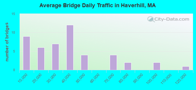
- 1,581,540Total average daily traffic
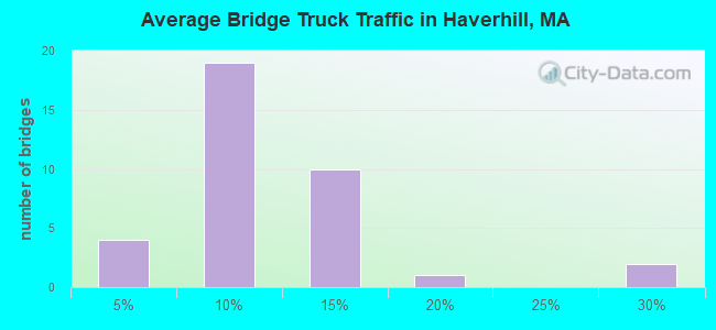
- 120,134Total average daily truck traffic
- National Bridge Inventory (NBI) Registered Bridges for Haverhill
- No street view available for this location
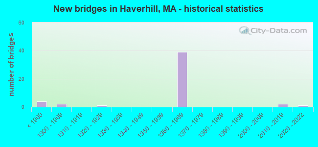
- New bridges - historical statistics
- 4Before 1900
- 21900-1909
- 11920-1929
- 391960-1969
- 22010-2019
- 12020-2022

- Reconstructed bridges - Historical Statistics
- 11960-1969
- 01970-1979
- 01980-1989
- 01990-1999
- 42000-2009
- 12010-2019
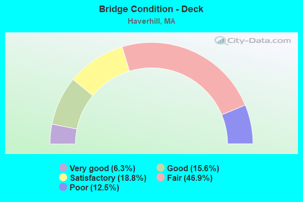
- Bridge Condition - Deck
- 6.3%Very good
- 15.6%Good
- 18.8%Satisfactory
- 46.9%Fair
- 12.5%Poor
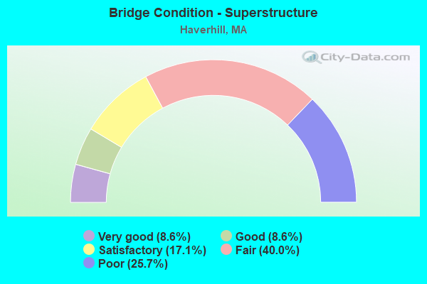
- Bridge Condition - Superstructure
- 8.6%Very good
- 8.6%Good
- 17.1%Satisfactory
- 40.0%Fair
- 25.7%Poor
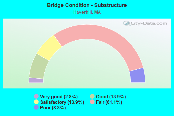
- Bridge Condition - Substructure
- 2.8%Very good
- 13.9%Good
- 13.9%Satisfactory
- 61.1%Fair
- 8.3%Poor
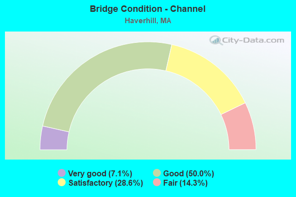
- Bridge Condition - Channel
- 7.1%Very good
- 50.0%Good
- 28.6%Satisfactory
- 14.3%Fair
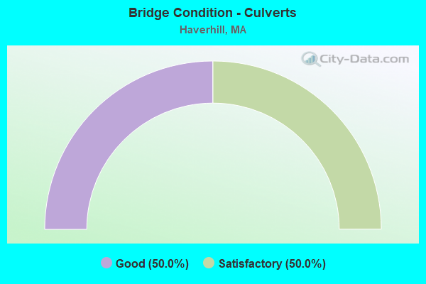
- Bridge Condition - Culverts
- 50.0%Good
- 50.0%Satisfactory
Find on map >> Show street view
Structure Number: H120572RTDOTNBI, Location: 1 MI E I495 (Lat: 42.750783, Lng: -71.109275), Route carried "on" structure: State highway 125, Year Built: 1961, Year Reconstructed: 2012, Status: Open, Structure Length: 6.40m (21.00ft), Average Daily Traffic: 11,500 (year 2018), Truck Traffic: 25%, Average Future Daily Traffic: 18,162 (year 2032), Design Load: H 20, Features Intersected: COMB FERRY RD&MBTA/BMRR
Minimum Vertical Clearance: 30+ m (98+ ft), Kilometerpoint: 1.915, Lanes on structure: 2, Lanes under structure: 2, Base Highway Network: Yes, Owner: State Highway Agency, Approaching Roadway Width: 12.2m (40.0ft), Skew: 1 degrees, Material/Design: Steel, Design/Construction: Stringer/Multi-beam, Number Of Spans In Main Unit: 4, Length of Maximum Span: 20.7m (67.9ft), Curb-To-Curb Width: 12.2m (40.0ft), Out-to-Out Width: 13.5m (44.3ft)
Condition: Deck: Good, Superstructure: Fair, Substructure: Fair, Operating Rating: 60.3 metric tons, Method Used To Determine Operating Rating: Load Factor (LF), Inventory Rating: 36.1 metric tons, Method Used To Determine Inventory Rating: Load Factor (LF), Structural Evaluation: Somewhat better than minimum adequacy, Deck Geometry: Better than present minimum criteria, Underclear: Meets minimum limits, Approach Roadway Alignment: Equal to present desirable criteria, Length Of Structure Improvement: 6.50m (21.33ft), Designated Inspection Frequency: Every 24 months, Inspection Date: September 2020, Bridge Improvement Cost: $3,447,000, Roadway Improvement Cost: $345,000, Total Project Cost: $5,171,000 ( Estimate for 2022), Deck Structure Type: Concrete Cast-file-Place, Wearing Surface/Protective System: Wearing Surface: Bituminous, Membrane: Built-up, Deck Protection: Epoxy Coated Reinforcing
Find on map >> Show street view
Structure Number: H120412YDDOTNBI, Location: .4 MI N MERRIMAC RIVER (Lat: 42.750000, Lng: -71.083333), Route carried "under" structure: Interstate 495, Year Built: 1964, Structure Length: 0. m, Average Daily Traffic: 40,000 (year 0000), Features Intersected: I 495 SB, Facility Carried by Structure: S 110 RIVER ST
Minimum Vertical Clearance: 5.16m (16.93ft), Kilometerpoint: 0.000, Lanes on structure: 3, Lanes under structure: 2, Material/Design: Steel, Design/Construction: Stringer/Multi-beam, Length of Maximum Span: 23.5m (77.1ft)
Find on map >> Show street view
Structure Number: H1204230GDOTNBI, Location: .7 MI N MERRIMAC RIVER (Lat: 42.783333, Lng: -71.116667), Route carried "under" structure: Interstate 495, Year Built: 1961, Structure Length: 0. m, Average Daily Traffic: 30,000 (year 0000), Features Intersected: I 495 NB, Facility Carried by Structure: ST 97
Minimum Vertical Clearance: 5.08m (16.67ft), Kilometerpoint: 171.815, Lanes on structure: 4, Lanes under structure: 6, Material/Design: Steel, Design/Construction: Stringer/Multi-beam, Length of Maximum Span: 21.6m (70.9ft)
Find on map >> Show street view
Structure Number: H1204330HDOTNBI, Location: .7 MI N MERRIMAC RIVER (Lat: 42.783333, Lng: -71.116667), Route carried "under" structure: Interstate 495, Year Built: 1961, Structure Length: 0. m, Average Daily Traffic: 30,000 (year 0000), Features Intersected: I 495 SB, Facility Carried by Structure: ST 97
Minimum Vertical Clearance: 5.08m (16.67ft), Kilometerpoint: 171.815, Lanes on structure: 6, Lanes under structure: 6, Material/Design: Steel, Design/Construction: Stringer/Multi-beam, Length of Maximum Span: 21.6m (70.9ft)
Find on map >> Show street view
Structure Number: H12044313DOTNBI, Location: 1 MI N ST110 (Lat: 42.783333, Lng: -71.116667), Route carried "under" structure: Interstate 495, Year Built: 1961, Structure Length: 0. m, Average Daily Traffic: 30,000 (year 0000), Features Intersected: I 495 SB, Facility Carried by Structure: HWY N BROADWAY
Minimum Vertical Clearance: 5.16m (16.93ft), Kilometerpoint: 173.478, Lanes on structure: 6, Lanes under structure: 2, Material/Design: Steel, Design/Construction: Stringer/Multi-beam, Length of Maximum Span: 22.6m (74.1ft)
Find on map >> Show street view
Structure Number: H12045312DOTNBI, Location: 000061 STATUTORY (Lat: 42.783333, Lng: -71.116667), Route carried "under" structure: Interstate 495, Year Built: 1961, Structure Length: 0. m, Average Daily Traffic: 30,000 (year 0000), Features Intersected: I 495 NB, Facility Carried by Structure: HWY N BROADWAY
Minimum Vertical Clearance: 5.16m (16.93ft), Kilometerpoint: 173.478, Lanes on structure: 6, Lanes under structure: 2, Material/Design: Steel, Design/Construction: Stringer/Multi-beam, Length of Maximum Span: 22.6m (74.1ft)
Find on map >> Show street view
Structure Number: H12046314DOTNBI, Location: 1.5 MI N ST110 (Lat: 42.800000, Lng: -71.116667), Route carried "under" structure: Interstate 495, Year Built: 1961, Structure Length: 0. m, Average Daily Traffic: 30,000 (year 0000), Features Intersected: I 495 NB, Facility Carried by Structure: HWY HILLDALE AVE
Minimum Vertical Clearance: 5.38m (17.65ft), Kilometerpoint: 174.162, Lanes on structure: 6, Lanes under structure: 2, Material/Design: Steel, Design/Construction: Stringer/Multi-beam, Length of Maximum Span: 22.6m (74.1ft)
Find on map >> Show street view
Structure Number: H12047315DOTNBI, Location: 000061 STATUTORY (Lat: 42.800000, Lng: -71.116667), Route carried "under" structure: Interstate 495, Year Built: 1961, Structure Length: 0. m, Average Daily Traffic: 30,000 (year 0000), Features Intersected: I 495 SB, Facility Carried by Structure: HWY HILLDALE AVE
Minimum Vertical Clearance: 5.38m (17.65ft), Kilometerpoint: 174.162, Lanes on structure: 3, Lanes under structure: 2, Material/Design: Steel, Design/Construction: Stringer/Multi-beam, Length of Maximum Span: 22.3m (73.2ft)
Find on map >> Show street view
Structure Number: H120502TMDOTNBI, Location: 2.4 MI N ST110 (Lat: 42.800000, Lng: -71.100000), Route carried "under" structure: Interstate 495, Year Built: 1961, Structure Length: 0. m, Average Daily Traffic: 40,000 (year 0000), Features Intersected: I 495 SB, Facility Carried by Structure: ST125
Minimum Vertical Clearance: 5.08m (16.67ft), Kilometerpoint: 173.983, Lanes on structure: 3, Lanes under structure: 6, Material/Design: Steel, Design/Construction: Stringer/Multi-beam, Length of Maximum Span: 23.8m (78.1ft)
Find on map >> Show street view
Structure Number: H120502TMDOTNBI, Location: 2.4 MI N ST110 (Lat: 42.800000, Lng: -71.100000), Route carried "under" structure: Interstate 495, Year Built: 1961, Structure Length: 0. m, Average Daily Traffic: 40,000 (year 0000), Features Intersected: I 495 NB, Facility Carried by Structure: ST125
Minimum Vertical Clearance: 5.08m (16.67ft), Kilometerpoint: 175.592, Lanes on structure: 3, Lanes under structure: 6, Material/Design: Steel, Design/Construction: Stringer/Multi-beam, Length of Maximum Span: 23.8m (78.1ft)
Find on map >> Show street view
Structure Number: H12051316DOTNBI, Location: .5 MI N ST125 (Lat: 42.800000, Lng: -71.083333), Route carried "under" structure: Interstate 495, Year Built: 1961, Structure Length: 0. m, Average Daily Traffic: 26,000 (year 0000), Features Intersected: I 495 SB, Facility Carried by Structure: HWY NORTH AVE
Minimum Vertical Clearance: 5.13m (16.83ft), Kilometerpoint: 0.000, Lanes on structure: 3, Lanes under structure: 2, Material/Design: Steel, Design/Construction: Stringer/Multi-beam, Length of Maximum Span: 22.6m (74.1ft)
Find on map >> Show street view
Structure Number: H12051316DOTNBI, Location: .5 MI N ST125 (Lat: 42.800000, Lng: -71.083333), Route carried "under" structure: Interstate 495, Year Built: 1961, Structure Length: 0. m, Average Daily Traffic: 26,000 (year 0000), Features Intersected: I 495 NB, Facility Carried by Structure: HWY NORTH AVE
Minimum Vertical Clearance: 5.13m (16.83ft), Kilometerpoint: 176.440, Lanes on structure: 3, Lanes under structure: 2, Material/Design: Steel, Design/Construction: Stringer/Multi-beam, Length of Maximum Span: 22.6m (74.1ft)