Bridge Statistics for Haverhill, Massachusetts (MA)
Condition, Traffic, Stress, Structural Evaluation, Project Costs
- National Bridge Inventory (NBI) Statistics
- 49Number of bridges
- 1,109ft / 338mTotal length
- $315,046,000Total costs
- 1,581,540Total average daily traffic
- 120,134Total average daily truck traffic
- National Bridge Inventory (NBI) Registered Bridges for Haverhill
- No street view available for this location
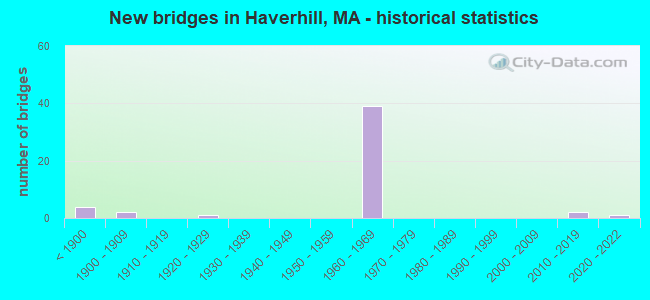
- New bridges - historical statistics
- 4Before 1900
- 21900-1909
- 11920-1929
- 391960-1969
- 22010-2019
- 12020-2022

- Reconstructed bridges - Historical Statistics
- 11960-1969
- 01970-1979
- 01980-1989
- 01990-1999
- 42000-2009
- 12010-2019
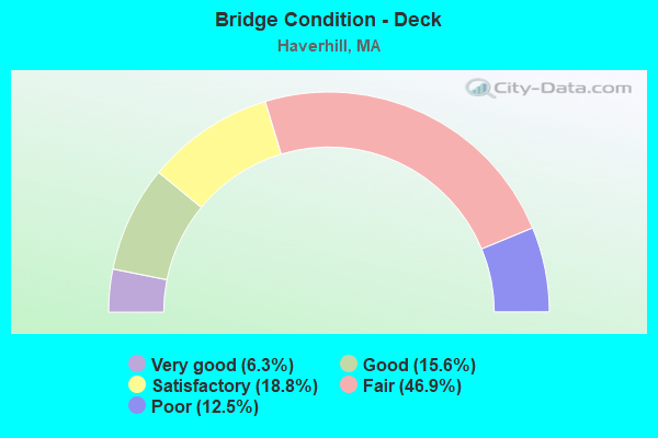
- Bridge Condition - Deck
- 6.3%Very good
- 15.6%Good
- 18.8%Satisfactory
- 46.9%Fair
- 12.5%Poor
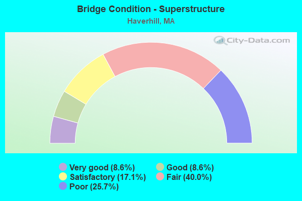
- Bridge Condition - Superstructure
- 8.6%Very good
- 8.6%Good
- 17.1%Satisfactory
- 40.0%Fair
- 25.7%Poor
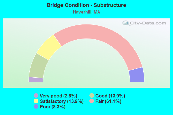
- Bridge Condition - Substructure
- 2.8%Very good
- 13.9%Good
- 13.9%Satisfactory
- 61.1%Fair
- 8.3%Poor
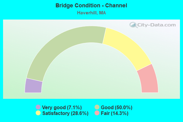
- Bridge Condition - Channel
- 7.1%Very good
- 50.0%Good
- 28.6%Satisfactory
- 14.3%Fair
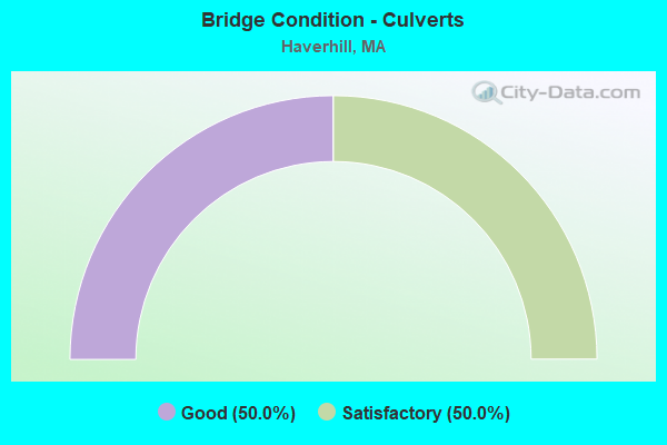
- Bridge Condition - Culverts
- 50.0%Good
- 50.0%Satisfactory
Find on map >> Show street view
Structure Number: H12005ADPDOT634, Location: .1 MI. N ST125 (Lat: 42.755331, Lng: -71.105878), Route carried "on" structure: State highway , Year Built: 2013, Status: Open, Structure Length: 2.02m (6.63ft), Average Daily Traffic: 1,600 (year 2018), Truck Traffic: 5%, Average Future Daily Traffic: 16 (year 0021), Design Load: HS 25 or greater, Features Intersected: RR MBTA/BMRR, Facility Carried by Structure: HWY FERRY RD
Minimum Vertical Clearance: 30+ m (98+ ft), Kilometerpoint: 1.368, Lanes on structure: 2, Owner: State Highway Agency, Approaching Roadway Width: 11.8m (38.7ft), Skew: 5 degrees, Material/Design: Steel, Design/Construction: Stringer/Multi-beam, Number Of Spans In Main Unit: 1, Length of Maximum Span: 19.7m (64.6ft), Curb or Sidewalk Widths: Left: 1.6m (5.2ft), Right: 0.0m, Curb-To-Curb Width: 9.0m (29.5ft), Out-to-Out Width: 11.5m (37.7ft)
Condition: Deck: Good, Superstructure: Very good, Substructure: Very good, Inventory Rating: 71.6 metric tons, Method Used To Determine Inventory Rating: Load Factor (LF), Structural Evaluation: Equal to present desirable criteria, Deck Geometry: Somewhat better than minimum adequacy, Underclear: High priority of corrective action, Approach Roadway Alignment: Equal to present desirable criteria, Length Of Structure Improvement: 2.10m (6.89ft), Designated Inspection Frequency: Every 24 months, Inspection Date: May 2020, Bridge Improvement Cost: $872,000, Roadway Improvement Cost: $88,000, Total Project Cost: $1,309,000 ( Estimate for 2022), Deck Structure Type: Concrete Cast-file-Place, Wearing Surface/Protective System: Wearing Surface: Integral Concrete, Membrane: Preformed Fabric, Deck Protection: Epoxy Coated Reinforcing
Find on map >> Show street view
Structure Number: H1200630XDOTNBI, Location: AT WSHGTN &RIVER STS (Lat: 42.770528, Lng: -71.086944), Route carried "on" structure: State highway , Year Built: 1906, Year Reconstructed: 2007, Status: Open, Structure Length: 26.15m (85.79ft), Average Daily Traffic: 10,665 (year 2018), Truck Traffic: 4%, Average Future Daily Traffic: 37,429 (year 2031), Design Load: HS 20, Features Intersected: WATER MERRIMACK RIVER, Facility Carried by Structure: HWY UPR CNTY BRI
Minimum Vertical Clearance: 30+ m (98+ ft), Kilometerpoint: 0.002, Lanes on structure: 2, Owner: State Highway Agency, Approaching Roadway Width: 9.1m (29.9ft), Skew: 1 degrees, Material/Design: Steel continuous, Design/Construction: Box Beam or Girders - Single/Spread, Number Of Spans In Main Unit: 6, Length of Maximum Span: 47.6m (156.2ft), Curb or Sidewalk Widths: Left: 1.5m (4.9ft), Right: 1.5m (4.9ft), Curb-To-Curb Width: 9.1m (29.9ft), Out-to-Out Width: 12.9m (42.3ft)
Condition: Deck: Good, Superstructure: Good, Substructure: Good, Channel: Satisfactory, Operating Rating: 87.8 metric tons, Method Used To Determine Operating Rating: Load Factor (LF), Inventory Rating: 52.5 metric tons, Method Used To Determine Inventory Rating: Load Factor (LF), Structural Evaluation: Better than present minimum criteria, Deck Geometry: Meets minimum limits, Waterway Adequacy: Equal to present desirable criteria, Approach Roadway Alignment: Meets minimum limits, Length Of Structure Improvement: 26.20m (85.96ft), Designated Inspection Frequency: Every 24 months, Critical Feature Inspection Frequency: Every 24 months, Underwater Inspection Frequency: Every 48 months, Inspection Date: July 2020, Critical Feature Inspection Date: July 2020, Underwater Inspection Date: August 2018, Bridge Improvement Cost: $10,623,000, Roadway Improvement Cost: $1,063,000, Total Project Cost: $15,935,000 ( Estimate for 2022), Deck Structure Type: Concrete Cast-file-Place, Wearing Surface/Protective System: Wearing Surface: Bituminous, Membrane: Built-up, Deck Protection: Epoxy Coated Reinforcing
Find on map >> Show street view
Structure Number: H1200730YDOTNBI, Location: .3 MI E HAVERHILL CENTER (Lat: 42.774006, Lng: -71.076258), Route carried "on" structure: State highway 125, Year Built: 1925, Status: Posted for load, Structure Length: 24.51m (80.41ft), Average Daily Traffic: 26,600 (year 2018), Truck Traffic: 7%, Average Future Daily Traffic: 42,483 (year 2031), Features Intersected: WATER MERRIMACK RIVER
Minimum Vertical Clearance: 30+ m (98+ ft), Kilometerpoint: 24.751, Lanes on structure: 4, Base Highway Network: Yes, Owner: State Highway Agency, Approaching Roadway Width: 14.0m (45.9ft), Material/Design: Steel, Design/Construction: Girder and Floorbeam System, Number Of Spans In Main Unit: 1, Number Of Approach Spans: 17, Length of Maximum Span: 24.4m (80.1ft), Curb or Sidewalk Widths: Left: 3.0m (9.8ft), Right: 3.0m (9.8ft), Curb-To-Curb Width: 14.0m (45.9ft), Out-to-Out Width: 20.7m (67.9ft)
Condition: Deck: Poor, Superstructure: Poor, Substructure: Poor, Channel: Fair, Operating Rating: 30.5 metric tons, Method Used To Determine Operating Rating: Load Factor (LF), Inventory Rating: 18.3 metric tons, Method Used To Determine Inventory Rating: Load Factor (LF), Structural Evaluation: Meets minimum limits, Deck Geometry: High priority of replacement, Waterway Adequacy: Equal to present desirable criteria, Approach Roadway Alignment: Equal to present desirable criteria, Bridge Posting: Required (Relationship of Operating Rating to Maximum Legal Load: 0.1 - 9.9% below), Length Of Structure Improvement: 23.90m (78.41ft), Designated Inspection Frequency: Every 12 months, Critical Feature Inspection Frequency: Every 24 months, Underwater Inspection Frequency: Every 12 months, Other Special Inspection Frequency: Every 12 months, Inspection Date: December 2020, Critical Feature Inspection Date: December 2020, Underwater Inspection Date: August 2021, Other Special Inspection Date: November 2021, Bridge Improvement Cost: $36,055,000, Roadway Improvement Cost: $3,606,000, Total Project Cost: $54,083,000 ( Estimate for 2022), Deck Structure Type: Concrete Cast-file-Place
Find on map >> Show street view
Structure Number: H120092PKMUNNBI, Location: JUST E OF RTE 97 (Lat: 42.775100, Lng: -71.085042), Route carried "on" structure: City street , Year Built: 1891, Status: Open, Structure Length: 0.94m (3.08ft), Average Daily Traffic: 4,500 (year 2019), Truck Traffic: 7%, Average Future Daily Traffic: 17,214 (year 2032), Features Intersected: OTHER LITTLE RIVER CUL, Facility Carried by Structure: HWY LOCKE ST
Minimum Vertical Clearance: 30+ m (98+ ft), Kilometerpoint: 0.048, Lanes on structure: 2, Owner: City or Municipal Highway Agency, Approaching Roadway Width: 10.7m (35.1ft), Material/Design: Masonry, Design/Construction: Arch - Deck, Number Of Spans In Main Unit: 1, Length of Maximum Span: 9.4m (30.8ft), Curb or Sidewalk Widths: Left: 2.1m (6.9ft), Right: 2.0m (6.6ft), Curb-To-Curb Width: 11.0m (36.1ft), Out-to-Out Width: 15.6m (51.2ft)
Condition: Superstructure: Good, Substructure: Good, Operating Rating: 61.8 metric tons, Method Used To Determine Operating Rating: Allowable Stress (AS), Inventory Rating: 61.8 metric tons, Method Used To Determine Inventory Rating: Allowable Stress (AS), Structural Evaluation: Better than present minimum criteria, Deck Geometry: Somewhat better than minimum adequacy, Waterway Adequacy: Superior to present desirable criteria, Approach Roadway Alignment: Equal to present desirable criteria, Length Of Structure Improvement: 1.00m (3.28ft), Designated Inspection Frequency: Every 24 months, Inspection Date: May 2021, Bridge Improvement Cost: $227,000, Roadway Improvement Cost: $23,000, Total Project Cost: $341,000 ( Estimate for 2022)
Find on map >> Show street view
Structure Number: H120102PLMUNNBI, Location: JUST E OF RTE 97 (Lat: 42.774856, Lng: -71.084383), Route carried "on" structure: City street , Year Built: 1903, Status: Open, Structure Length: 0.94m (3.08ft), Average Daily Traffic: 3,800 (year 2019), Truck Traffic: 7%, Average Future Daily Traffic: 17,530 (year 2032), Features Intersected: OTHER LITTLE RIVER CUL, Facility Carried by Structure: HWY LOCUST ST
Minimum Vertical Clearance: 30+ m (98+ ft), Kilometerpoint: 0.064, Lanes on structure: 2, Owner: City or Municipal Highway Agency, Approaching Roadway Width: 10.4m (34.1ft), Material/Design: Concrete, Design/Construction: Arch - Deck, Number Of Spans In Main Unit: 1, Length of Maximum Span: 9.4m (30.8ft), Curb or Sidewalk Widths: Left: 2.1m (6.9ft), Right: 2.2m (7.2ft), Curb-To-Curb Width: 10.3m (33.8ft), Out-to-Out Width: 14.8m (48.6ft)
Condition: Superstructure: Good, Substructure: Good, Structural Evaluation: Better than present minimum criteria, Deck Geometry: Meets minimum limits, Waterway Adequacy: Superior to present desirable criteria, Approach Roadway Alignment: Somewhat better than minimum adequacy, Length Of Structure Improvement: 1.00m (3.28ft), Designated Inspection Frequency: Every 24 months, Inspection Date: May 2021, Bridge Improvement Cost: $293,000, Roadway Improvement Cost: $30,000, Total Project Cost: $440,000 ( Estimate for 2022)
Find on map >> Show street view
Structure Number: H1201130FDOTNBI, Location: .4 MI NW HAVERHILL CENTER (Lat: 42.777436, Lng: -71.088489), Route carried "on" structure: State highway 97, Year Built: 1887, Status: Open, Structure Length: 1.13m (3.71ft), Average Daily Traffic: 24,700 (year 2020), Truck Traffic: 5%, Average Future Daily Traffic: 23,847 (year 2031), Features Intersected: WATER LITTLE RIVER
Minimum Vertical Clearance: 30+ m (98+ ft), Kilometerpoint: 31.690, Lanes on structure: 2, Owner: State Highway Agency, Approaching Roadway Width: 19.2m (63.0ft), Skew: 1 degrees, Material/Design: Masonry, Design/Construction: Arch - Deck, Number Of Spans In Main Unit: 1, Length of Maximum Span: 10.1m (33.1ft), Curb or Sidewalk Widths: Left: 2.1m (6.9ft), Right: 2.1m (6.9ft), Curb-To-Curb Width: 12.7m (41.7ft), Out-to-Out Width: 19.3m (63.3ft)
Condition: Superstructure: Satisfactory, Substructure: Satisfactory, Channel: Satisfactory, Operating Rating: 76.1 metric tons, Method Used To Determine Operating Rating: Allowable Stress (AS), Inventory Rating: 76.1 metric tons, Method Used To Determine Inventory Rating: Allowable Stress (AS), Structural Evaluation: Equal to present minimum criteria, Deck Geometry: Somewhat better than minimum adequacy, Waterway Adequacy: Equal to present desirable criteria, Approach Roadway Alignment: Equal to present desirable criteria, Length Of Structure Improvement: 1.20m (3.94ft), Designated Inspection Frequency: Every 24 months, Underwater Inspection Frequency: Every 36 months, Inspection Date: July 2020, Underwater Inspection Date: August 2020, Bridge Improvement Cost: $80,000, Roadway Improvement Cost: $9,000, Total Project Cost: $121,000 ( Estimate for 2022), Wearing Surface/Protective System: Wearing Surface: Bituminous
Find on map >> Show street view
Structure Number: H12013BMYMUNNBI, Location: X OF MILLVALE ROAD (Lat: 42.779564, Lng: -71.028033), Route carried "on" structure: City street , Year Built: 2017, Status: Open, Structure Length: 0.65m (2.13ft), Average Daily Traffic: 1,500 (year 2018), Truck Traffic: 9%, Design Load: HL 93, Features Intersected: WATER MILLVALE BROOK, Facility Carried by Structure: HWY E BROADWAY
Minimum Vertical Clearance: 30+ m (98+ ft), Kilometerpoint: 0.000, Lanes on structure: 2, Owner: Town or Township Highway Agency, Approaching Roadway Width: 9.1m (29.9ft), Skew: 3 degrees, Material/Design: Concrete, Design/Construction: Culvert, Number Of Spans In Main Unit: 1, Length of Maximum Span: 6.5m (21.3ft), Curb-To-Curb Width: 9.1m (29.9ft), Out-to-Out Width: 11.8m (38.7ft)
Condition: Channel: Good, Culverts: Good, Operating Rating: 58.3 metric tons, Method Used To Determine Operating Rating: Load and Resistance Factor Rating (LRFR) rating reported by rating factor(RF) method using HL-93 loadings, Inventory Rating: 45.4 metric tons, Method Used To Determine Inventory Rating: Load and Resistance Factor Rating (LRFR) rating reported by rating factor(RF) method using HL-93 loadings, Structural Evaluation: Better than present minimum criteria, Deck Geometry: Somewhat better than minimum adequacy, Waterway Adequacy: Better than present minimum criteria, Approach Roadway Alignment: Somewhat better than minimum adequacy, Designated Inspection Frequency: Every 24 months, Inspection Date: May 2020, Wearing Surface/Protective System: Wearing Surface: Bituminous
Find on map >> Show street view
Structure Number: H12020311DOTNBI, Location: AT WEST NEWBURY MERRIMAC (Lat: 42.810725, Lng: -70.999778), Route carried "on" structure: State highway , Year Built: 1883, Year Reconstructed: 2013, Status: Open, Structure Length: 24.75m (81.20ft), Average Daily Traffic: 6,896 (year 2019), Truck Traffic: 5%, Average Future Daily Traffic: 10,265 (year 2032), Design Load: HS 20, Features Intersected: WATER MERRIMACK RIVER, Facility Carried by Structure: HWY EAST MAIN ST
Minimum Vertical Clearance: 3.86m (12.66ft), Kilometerpoint: 0.002, Lanes on structure: 2, Owner: State Highway Agency, Approaching Roadway Width: 7.9m (25.9ft), Navigation Control: Yes ( Vertical Clearance: 5.2m (17.1ft), Horizontal Clearance: 16.5m (54.1ft)), Material/Design: Steel, Design/Construction: Movable - Swing, Number Of Spans In Main Unit: 1, Number Of Approach Spans: 5, Length of Maximum Span: 58.5m (191.9ft), Curb-To-Curb Width: 6.2m (20.3ft), Out-to-Out Width: 6.4m (21.0ft)
Condition: Deck: Satisfactory, Superstructure: Fair, Substructure: Fair, Channel: Fair, Operating Rating: 39.2 metric tons, Method Used To Determine Operating Rating: Load Factor (LF), Inventory Rating: 23.5 metric tons, Method Used To Determine Inventory Rating: Load Factor (LF), Structural Evaluation: Somewhat better than minimum adequacy, Deck Geometry: High priority of replacement, Waterway Adequacy: Superior to present desirable criteria, Approach Roadway Alignment: High priority of corrective action, Length Of Structure Improvement: 24.00m (78.74ft), Designated Inspection Frequency: Every 24 months, Critical Feature Inspection Frequency: Every 24 months, Underwater Inspection Frequency: Every 36 months, Inspection Date: November 2021, Critical Feature Inspection Date: November 2021, Underwater Inspection Date: September 2019, Bridge Improvement Cost: $17,097,000, Roadway Improvement Cost: $1,710,000, Total Project Cost: $25,646,000 ( Estimate for 2022), Deck Structure Type: Other, Wearing Surface/Protective System: Wearing Surface: Latex Concrete
Find on map >> Show street view
Structure Number: H12025310DOTNBI, Location: .16 KM S MERRIMAC RIVER (Lat: 42.772703, Lng: -71.075986), Route carried "on" structure: State highway 125, Year Built: 1850, Year Reconstructed: 1968, Status: Posted for load, Structure Length: 0.98m (3.22ft), Average Daily Traffic: 26,000 (year 2019), Truck Traffic: 7%, Average Future Daily Traffic: 21,652 (year 2032), Design Load: H 20, Features Intersected: RR BMRR (ABANDONED)
Minimum Vertical Clearance: 30+ m (98+ ft), Kilometerpoint: 24.592, Lanes on structure: 2, Base Highway Network: Yes, Owner: State Highway Agency, Approaching Roadway Width: 19.2m (63.0ft), Material/Design: Prestressed concrete, Design/Construction: Box Beam or Girders - Multiple, Number Of Spans In Main Unit: 1, Length of Maximum Span: 9.8m (32.2ft), Curb or Sidewalk Widths: Left: 3.0m (9.8ft), Right: 3.4m (11.2ft), Curb-To-Curb Width: 14.2m (46.6ft), Out-to-Out Width: 22.1m (72.5ft)
Condition: Deck: Poor, Superstructure: Poor, Substructure: Fair, Operating Rating: 50.3 metric tons, Method Used To Determine Operating Rating: Load Factor (LF), Inventory Rating: 25.9 metric tons, Method Used To Determine Inventory Rating: Load Factor (LF), Structural Evaluation: Meets minimum limits, Deck Geometry: Superior to present desirable criteria, Underclear: High priority of replacement, Approach Roadway Alignment: Equal to present desirable criteria, Length Of Structure Improvement: 1.70m (5.58ft), Designated Inspection Frequency: Every 12 months, Other Special Inspection Frequency: Every 12 months, Inspection Date: Febuary 2021, Other Special Inspection Date: Febuary 2022, Bridge Improvement Cost: $1,897,000, Roadway Improvement Cost: $190,000, Total Project Cost: $2,846,000 ( Estimate for 2022), Deck Structure Type: Concrete Precast Panels, Wearing Surface/Protective System: Wearing Surface: Latex Concrete, Membrane: Built-up
Find on map >> Show street view
Structure Number: H120342WRDOTNBI, Location: .7 MI S ST110 (Lat: 42.804639, Lng: -71.065889), Route carried "on" structure: Interstate 495, Year Built: 1964, Status: Temporarily open, Structure Length: 3.87m (12.70ft), Average Daily Traffic: 65,000 (year 2017), Truck Traffic: 17%, Average Future Daily Traffic: 100,128 (year 2032), Design Load: HS 20+Mod, Features Intersected: ST108 NEWTON RD
Minimum Vertical Clearance: 30+ m (98+ ft), Kilometerpoint: 177.948, Lanes on structure: 3, Lanes under structure: 2, Base Highway Network: Yes, Owner: State Highway Agency, Approaching Roadway Width: 15.2m (49.9ft), Material/Design: Steel, Design/Construction: Stringer/Multi-beam, Number Of Spans In Main Unit: 3, Length of Maximum Span: 17.1m (56.1ft), Curb-To-Curb Width: 15.2m (49.9ft), Out-to-Out Width: 17.1m (56.1ft)
Condition: Deck: Fair, Superstructure: Fair, Substructure: Fair, Operating Rating: 50.6 metric tons, Method Used To Determine Operating Rating: Load Factor (LF), Inventory Rating: 30.3 metric tons, Method Used To Determine Inventory Rating: Load Factor (LF), Structural Evaluation: Somewhat better than minimum adequacy, Deck Geometry: Meets minimum limits, Underclear: Meets minimum limits, Approach Roadway Alignment: Equal to present minimum criteria, Length Of Structure Improvement: 3.90m (12.80ft), Designated Inspection Frequency: Every 24 months, Inspection Date: January 2021, Bridge Improvement Cost: $2,620,000, Roadway Improvement Cost: $263,000, Total Project Cost: $3,931,000 ( Estimate for 2022), Deck Structure Type: Concrete Cast-file-Place, Wearing Surface/Protective System: Wearing Surface: Bituminous, Membrane: Built-up
Find on map >> Show street view
Structure Number: H120342WTDOTNBI, Location: .7 MI S ST110 (Lat: 42.805278, Lng: -71.065792), Route carried "on" structure: Interstate 495, Year Built: 1964, Status: Temporarily open, Structure Length: 3.87m (12.70ft), Average Daily Traffic: 65,000 (year 2015), Truck Traffic: 13%, Average Future Daily Traffic: 100,128 (year 2032), Design Load: HS 20+Mod, Features Intersected: ST108 NEWTON RD
Minimum Vertical Clearance: 30+ m (98+ ft), Kilometerpoint: 177.948, Lanes on structure: 3, Lanes under structure: 2, Base Highway Network: Yes, Owner: State Highway Agency, Approaching Roadway Width: 15.2m (49.9ft), Material/Design: Steel, Design/Construction: Stringer/Multi-beam, Number Of Spans In Main Unit: 3, Length of Maximum Span: 17.1m (56.1ft), Curb-To-Curb Width: 15.2m (49.9ft), Out-to-Out Width: 17.1m (56.1ft)
Condition: Deck: Fair, Superstructure: Fair, Substructure: Fair, Operating Rating: 50.6 metric tons, Method Used To Determine Operating Rating: Load Factor (LF), Inventory Rating: 30.3 metric tons, Method Used To Determine Inventory Rating: Load Factor (LF), Structural Evaluation: Somewhat better than minimum adequacy, Deck Geometry: Meets minimum limits, Underclear: Meets minimum limits, Approach Roadway Alignment: Equal to present desirable criteria, Length Of Structure Improvement: 3.90m (12.80ft), Designated Inspection Frequency: Every 24 months, Inspection Date: January 2021, Bridge Improvement Cost: $2,620,000, Roadway Improvement Cost: $263,000, Total Project Cost: $3,931,000 ( Estimate for 2022), Deck Structure Type: Concrete Cast-file-Place, Wearing Surface/Protective System: Wearing Surface: Bituminous, Membrane: Built-up
Find on map >> Show street view
Structure Number: H120352WUDOTNBI, Location: 3.5 KM N ST125 (Lat: 42.802394, Lng: -71.052133), Route carried "on" structure: Interstate 495, Year Built: 1964, Status: Open, Structure Length: 4.24m (13.91ft), Average Daily Traffic: 79,962 (year 2019), Truck Traffic: 10%, Average Future Daily Traffic: 134,240 (year 2031), Design Load: HS 20+Mod, Features Intersected: ST110 AMESBURY ST
Minimum Vertical Clearance: 30+ m (98+ ft), Kilometerpoint: 179.097, Lanes on structure: 3, Lanes under structure: 2, Base Highway Network: Yes, Owner: State Highway Agency, Approaching Roadway Width: 15.8m (51.8ft), Skew: 2 degrees, Material/Design: Steel, Design/Construction: Stringer/Multi-beam, Number Of Spans In Main Unit: 3, Length of Maximum Span: 19.5m (64.0ft), Curb-To-Curb Width: 15.8m (51.8ft), Out-to-Out Width: 17.7m (58.1ft)
Condition: Deck: Fair, Superstructure: Fair, Substructure: Fair, Operating Rating: 41.4 metric tons, Method Used To Determine Operating Rating: Allowable Stress (AS), Inventory Rating: 25.5 metric tons, Method Used To Determine Inventory Rating: Allowable Stress (AS), Structural Evaluation: Somewhat better than minimum adequacy, Deck Geometry: Somewhat better than minimum adequacy, Underclear: Meets minimum limits, Approach Roadway Alignment: Equal to present desirable criteria, Length Of Structure Improvement: 4.30m (14.11ft), Designated Inspection Frequency: Every 24 months, Inspection Date: May 2020, Bridge Improvement Cost: $2,990,000, Roadway Improvement Cost: $300,000, Total Project Cost: $4,486,000 ( Estimate for 2022), Deck Structure Type: Concrete Cast-file-Place, Wearing Surface/Protective System: Wearing Surface: Bituminous, Membrane: Built-up, Deck Protection: Other
Find on map >> Show street view
Structure Number: H120352WVDOTNBI, Location: 3.7 KM N ST125 (Lat: 42.802758, Lng: -71.051764), Route carried "on" structure: Interstate 495, Year Built: 1964, Status: Temporarily open, Structure Length: 4.28m (14.04ft), Average Daily Traffic: 37,519 (year 2019), Truck Traffic: 11%, Average Future Daily Traffic: 134,240 (year 2031), Design Load: HS 20, Features Intersected: ST110 AMESBURY RD
Minimum Vertical Clearance: 30+ m (98+ ft), Kilometerpoint: 179.097, Lanes on structure: 3, Lanes under structure: 2, Base Highway Network: Yes, Owner: State Highway Agency, Approaching Roadway Width: 15.8m (51.8ft), Skew: 2 degrees, Material/Design: Steel, Design/Construction: Stringer/Multi-beam, Number Of Spans In Main Unit: 3, Length of Maximum Span: 19.5m (64.0ft), Curb-To-Curb Width: 15.8m (51.8ft), Out-to-Out Width: 17.7m (58.1ft)
Condition: Deck: Fair, Superstructure: Fair, Substructure: Fair, Operating Rating: 56.5 metric tons, Method Used To Determine Operating Rating: Load Factor (LF), Inventory Rating: 33.9 metric tons, Method Used To Determine Inventory Rating: Load Factor (LF), Structural Evaluation: Somewhat better than minimum adequacy, Deck Geometry: Somewhat better than minimum adequacy, Underclear: Meets minimum limits, Approach Roadway Alignment: Equal to present desirable criteria, Length Of Structure Improvement: 4.30m (14.11ft), Designated Inspection Frequency: Every 24 months, Inspection Date: May 2020, Bridge Improvement Cost: $2,990,000, Roadway Improvement Cost: $300,000, Total Project Cost: $4,486,000 ( Estimate for 2022), Deck Structure Type: Concrete Cast-file-Place, Wearing Surface/Protective System: Wearing Surface: Bituminous, Membrane: Built-up
Find on map >> Show street view
Structure Number: H120362WWDOTNBI, Location: 1.6 KM N ST110 (Lat: 42.805806, Lng: -71.033333), Route carried "on" structure: Interstate 495, Year Built: 1964, Status: Open, Structure Length: 4.13m (13.55ft), Average Daily Traffic: 35,355 (year 2018), Truck Traffic: 11%, Average Future Daily Traffic: 94,758 (year 2032), Design Load: HS 20+Mod, Features Intersected: HWY MIDDLE RD
Minimum Vertical Clearance: 30+ m (98+ ft), Kilometerpoint: 180.732, Lanes on structure: 3, Lanes under structure: 2, Base Highway Network: Yes, Owner: State Highway Agency, Approaching Roadway Width: 15.2m (49.9ft), Skew: 2 degrees, Material/Design: Steel, Design/Construction: Stringer/Multi-beam, Number Of Spans In Main Unit: 3, Length of Maximum Span: 14.3m (46.9ft), Curb-To-Curb Width: 15.2m (49.9ft), Out-to-Out Width: 17.1m (56.1ft)
Condition: Deck: Satisfactory, Superstructure: Fair, Substructure: Fair, Operating Rating: 56.5 metric tons, Method Used To Determine Operating Rating: Load Factor (LF), Inventory Rating: 33.8 metric tons, Method Used To Determine Inventory Rating: Load Factor (LF), Structural Evaluation: Somewhat better than minimum adequacy, Deck Geometry: Meets minimum limits, Underclear: Meets minimum limits, Approach Roadway Alignment: Equal to present desirable criteria, Length Of Structure Improvement: 4.20m (13.78ft), Designated Inspection Frequency: Every 24 months, Inspection Date: March 2021, Bridge Improvement Cost: $2,822,000, Roadway Improvement Cost: $283,000, Total Project Cost: $4,234,000 ( Estimate for 2022), Deck Structure Type: Concrete Cast-file-Place, Wearing Surface/Protective System: Wearing Surface: Bituminous, Membrane: Built-up
Find on map >> Show street view
Structure Number: H120362WXDOTNBI, Location: 1.6 KM N ST110 (Lat: 42.806319, Lng: -71.033597), Route carried "on" structure: Interstate 495, Year Built: 1964, Status: Temporarily open, Structure Length: 3.80m (12.47ft), Average Daily Traffic: 35,700 (year 2018), Truck Traffic: 10%, Average Future Daily Traffic: 94,758 (year 2032), Design Load: HS 20+Mod, Features Intersected: HWY MIDDLE RD
Minimum Vertical Clearance: 30+ m (98+ ft), Kilometerpoint: 180.732, Lanes on structure: 3, Lanes under structure: 2, Base Highway Network: Yes, Owner: State Highway Agency, Approaching Roadway Width: 15.2m (49.9ft), Skew: 2 degrees, Material/Design: Steel, Design/Construction: Stringer/Multi-beam, Number Of Spans In Main Unit: 3, Length of Maximum Span: 14.4m (47.2ft), Curb-To-Curb Width: 15.2m (49.9ft), Out-to-Out Width: 17.1m (56.1ft)
Condition: Deck: Satisfactory, Superstructure: Poor, Substructure: Satisfactory, Operating Rating: 56.5 metric tons, Method Used To Determine Operating Rating: Load Factor (LF), Inventory Rating: 33.8 metric tons, Method Used To Determine Inventory Rating: Load Factor (LF), Structural Evaluation: Meets minimum limits, Deck Geometry: Meets minimum limits, Underclear: Meets minimum limits, Approach Roadway Alignment: Equal to present desirable criteria, Length Of Structure Improvement: 3.90m (12.80ft), Designated Inspection Frequency: Every 12 months, Other Special Inspection Frequency: Every 12 months, Inspection Date: March 2021, Other Special Inspection Date: March 2021, Bridge Improvement Cost: $2,620,000, Roadway Improvement Cost: $263,000, Total Project Cost: $3,931,000 ( Estimate for 2022), Deck Structure Type: Concrete Cast-file-Place, Wearing Surface/Protective System: Wearing Surface: Bituminous, Membrane: Built-up
Find on map >> Show street view
Structure Number: H1203789VDOTNBI, Location: 1.1M N OF EXIT 52 (Lat: 42.806939, Lng: -71.032081), Route carried "on" structure: Interstate 495, Year Built: 1964, Status: Open, Structure Length: 0.62m (2.03ft), Average Daily Traffic: 74,950 (year 2021), Truck Traffic: 8%, Design Load: HS 20, Features Intersected: WATER E MEADOW RIVER
Minimum Vertical Clearance: 30+ m (98+ ft), Kilometerpoint: 0.000, Lanes on structure: 6, Base Highway Network: Yes, Owner: State Highway Agency, Approaching Roadway Width: 29.3m (96.1ft), Skew: 23 degrees, Material/Design: Concrete, Design/Construction: Culvert, Number Of Spans In Main Unit: 2, Length of Maximum Span: 2.8m (9.2ft), Curb-To-Curb Width: 63.1m (207.0ft), Out-to-Out Width: 118.1m (387.5ft)
Condition: Channel: Good, Culverts: Satisfactory, Structural Evaluation: Equal to present minimum criteria, Deck Geometry: Superior to present desirable criteria, Waterway Adequacy: Equal to present desirable criteria, Approach Roadway Alignment: Equal to present desirable criteria, Length Of Structure Improvement: 8.00m (26.25ft), Designated Inspection Frequency: Every 24 months, Underwater Inspection Frequency: Every 36 months, Inspection Date: June 2021, Underwater Inspection Date: November 2020, Bridge Improvement Cost: $312,000, Roadway Improvement Cost: $32,000, Total Project Cost: $469,000 ( Estimate for 2022), Wearing Surface/Protective System: Wearing Surface: Bituminous
Find on map >> Show street view
Structure Number: H120382WYDOTNBI, Location: 3.2 KM N ST110 (Lat: 42.816611, Lng: -71.021972), Route carried "on" structure: Interstate 495, Year Built: 1964, Status: Temporarily open, Structure Length: 3.50m (11.48ft), Average Daily Traffic: 35,000 (year 2018), Truck Traffic: 10%, Average Future Daily Traffic: 94,758 (year 2032), Design Load: HS 20, Features Intersected: HWY AMESBURY LINE RD
Minimum Vertical Clearance: 30+ m (98+ ft), Kilometerpoint: 182.269, Lanes on structure: 3, Lanes under structure: 2, Base Highway Network: Yes, Owner: State Highway Agency, Approaching Roadway Width: 15.2m (49.9ft), Skew: 1 degrees, Material/Design: Steel, Design/Construction: Stringer/Multi-beam, Number Of Spans In Main Unit: 3, Length of Maximum Span: 13.9m (45.6ft), Curb-To-Curb Width: 15.2m (49.9ft), Out-to-Out Width: 17.1m (56.1ft)
Condition: Deck: Fair, Superstructure: Poor, Substructure: Satisfactory, Operating Rating: 56.5 metric tons, Method Used To Determine Operating Rating: Load Factor (LF), Inventory Rating: 33.8 metric tons, Method Used To Determine Inventory Rating: Load Factor (LF), Structural Evaluation: Meets minimum limits, Deck Geometry: Meets minimum limits, Underclear: Meets minimum limits, Approach Roadway Alignment: Equal to present desirable criteria, Length Of Structure Improvement: 3.60m (11.81ft), Designated Inspection Frequency: Every 12 months, Other Special Inspection Frequency: Every 12 months, Inspection Date: March 2021, Other Special Inspection Date: March 2021, Bridge Improvement Cost: $2,419,000, Roadway Improvement Cost: $242,000, Total Project Cost: $3,629,000 ( Estimate for 2022), Deck Structure Type: Concrete Cast-file-Place, Wearing Surface/Protective System: Wearing Surface: Bituminous, Membrane: Built-up
Find on map >> Show street view
Structure Number: H120382X0DOTNBI, Location: 3.2 KM N ST110 (Lat: 42.817028, Lng: -71.022431), Route carried "on" structure: Interstate 495, Year Built: 1964, Status: Open, Structure Length: 3.40m (11.15ft), Average Daily Traffic: 35,700 (year 2018), Truck Traffic: 10%, Average Future Daily Traffic: 94,758 (year 2032), Design Load: HS 20, Features Intersected: HWY AMESBURY LINE RD
Minimum Vertical Clearance: 30+ m (98+ ft), Kilometerpoint: 182.269, Lanes on structure: 3, Lanes under structure: 2, Base Highway Network: Yes, Owner: State Highway Agency, Approaching Roadway Width: 15.2m (49.9ft), Skew: 1 degrees, Material/Design: Steel, Design/Construction: Stringer/Multi-beam, Number Of Spans In Main Unit: 3, Length of Maximum Span: 13.8m (45.3ft), Curb-To-Curb Width: 15.2m (49.9ft), Out-to-Out Width: 17.1m (56.1ft)
Condition: Deck: Fair, Superstructure: Poor, Substructure: Satisfactory, Operating Rating: 56.5 metric tons, Method Used To Determine Operating Rating: Load Factor (LF), Inventory Rating: 33.8 metric tons, Method Used To Determine Inventory Rating: Load Factor (LF), Structural Evaluation: Meets minimum limits, Deck Geometry: Meets minimum limits, Underclear: Meets minimum limits, Approach Roadway Alignment: Equal to present desirable criteria, Length Of Structure Improvement: 3.50m (11.48ft), Designated Inspection Frequency: Every 12 months, Other Special Inspection Frequency: Every 12 months, Inspection Date: March 2021, Other Special Inspection Date: March 2021, Bridge Improvement Cost: $2,351,000, Roadway Improvement Cost: $236,000, Total Project Cost: $3,527,000 ( Estimate for 2022), Deck Structure Type: Concrete Cast-file-Place, Wearing Surface/Protective System: Wearing Surface: Bituminous, Membrane: Built-up
Find on map >> Show street view
Structure Number: H120392WMDOTNBI, Location: .4 MI S ST110 (Lat: 42.768508, Lng: -71.120231), Route carried "on" structure: Interstate 495, Year Built: 1961, Year Reconstructed: 2021, Status: Closed, Structure Length: 21.89m (71.82ft), Average Future Daily Traffic: 101,391 (year 2031), Design Load: HS 20+Mod, Features Intersected: WATER MERRIMACK RIVER
Minimum Vertical Clearance: 30+ m (98+ ft), Kilometerpoint: 171.118, Lanes on structure: 3, Base Highway Network: Yes, Owner: State Highway Agency, Approaching Roadway Width: 28.7m (94.2ft), Material/Design: Steel continuous, Design/Construction: Stringer/Multi-beam, Number Of Spans In Main Unit: 5, Length of Maximum Span: 84.7m (277.9ft), Curb or Sidewalk Widths: Left: 0.5m (1.6ft), Right: 0.5m (1.6ft), Curb-To-Curb Width: 22.8m (74.8ft), Out-to-Out Width: 23.8m (78.1ft)
Condition: Deck: Very good, Superstructure: Very good, Substructure: Good, Channel: Satisfactory, Operating Rating: 63.5 metric tons, Method Used To Determine Operating Rating: Allowable Stress (AS), Inventory Rating: 35.0 metric tons, Method Used To Determine Inventory Rating: Allowable Stress (AS), Structural Evaluation: Better than present minimum criteria, Deck Geometry: Superior to present desirable criteria, Waterway Adequacy: Equal to present desirable criteria, Approach Roadway Alignment: Equal to present minimum criteria, Designated Inspection Frequency: Every 12 months, Inspection Date: December 2020, Deck Structure Type: Concrete Cast-file-Place, Wearing Surface/Protective System: Wearing Surface: Bituminous, Membrane: Built-up
Find on map >> Show street view
Structure Number: H120392WNDOTNBI, Location: .4 MI S ST110 (Lat: 42.768642, Lng: -71.120778), Route carried "on" structure: Interstate 495, Year Built: 1961, Status: Closed, Structure Length: 21.85m (71.69ft), Average Future Daily Traffic: 76,438 (year 2031), Design Load: HS 20+Mod, Features Intersected: WATER MERRIMACK RIVER
Minimum Vertical Clearance: 30+ m (98+ ft), Kilometerpoint: 171.118, Lanes on structure: 3, Base Highway Network: Yes, Owner: State Highway Agency, Approaching Roadway Width: 17.7m (58.1ft), Material/Design: Steel continuous, Design/Construction: Stringer/Multi-beam, Number Of Spans In Main Unit: 5, Length of Maximum Span: 51.2m (168.0ft), Curb or Sidewalk Widths: Left: 0.5m (1.6ft), Right: 0.5m (1.6ft), Curb-To-Curb Width: 14.0m (45.9ft), Out-to-Out Width: 15.8m (51.8ft)
Condition: Substructure: Fair, Channel: Satisfactory, Operating Rating: 62.5 metric tons, Method Used To Determine Operating Rating: Allowable Stress (AS), Inventory Rating: 34.3 metric tons, Method Used To Determine Inventory Rating: Allowable Stress (AS), Structural Evaluation: Somewhat better than minimum adequacy, Deck Geometry: Meets minimum limits, Waterway Adequacy: Equal to present desirable criteria, Approach Roadway Alignment: Better than present minimum criteria, Length Of Structure Improvement: 21.90m (71.85ft), Designated Inspection Frequency: Every 24 months, Inspection Date: December 2020, Bridge Improvement Cost: $13,592,000, Roadway Improvement Cost: $1,360,000, Total Project Cost: $20,389,000 ( Estimate for 2022), Deck Structure Type: Concrete Cast-file-Place, Wearing Surface/Protective System: Wearing Surface: Bituminous, Membrane: Built-up
Find on map >> Show street view
Structure Number: H12039C32DOTNBI, Location: .4 MI S ST110 (Lat: 42.768508, Lng: -71.120231), Route carried "on" structure: Interstate 495, Year Built: 2021, Status: Open, Structure Length: 21.89m (71.82ft), Average Daily Traffic: 118,146 (year 2019), Truck Traffic: 7%, Design Load: HL 93, Features Intersected: WATER MERRIMACK RIVER
Minimum Vertical Clearance: 99.00m (324.80ft), Kilometerpoint: 171.118, Lanes on structure: 6, Base Highway Network: Yes, Owner: State Highway Agency, Approaching Roadway Width: 28.7m (94.2ft), Skew: 30 degrees, Material/Design: Steel continuous, Design/Construction: Stringer/Multi-beam, Number Of Spans In Main Unit: 3, Length of Maximum Span: 84.7m (277.9ft), Curb-To-Curb Width: 22.8m (74.8ft), Out-to-Out Width: 23.8m (78.1ft)
Condition: Deck: Very good, Superstructure: Very good, Substructure: Good, Channel: Very good, Operating Rating: 42.1 metric tons, Method Used To Determine Operating Rating: Assigned ratings based on Load and Resistance Factor Design (LRFD) reported by rating factor (RF) using HL93 loadings, Inventory Rating: 32.4 metric tons, Method Used To Determine Inventory Rating: Assigned ratings based on Load and Resistance Factor Design (LRFD) reported by rating factor (RF) using HL93 loadings, Structural Evaluation: Better than present minimum criteria, Deck Geometry: Meets minimum limits, Waterway Adequacy: Equal to present desirable criteria, Approach Roadway Alignment: Equal to present desirable criteria, Designated Inspection Frequency: Every 24 months, Inspection Date: December 2020, Deck Structure Type: Concrete Cast-file-Place, Wearing Surface/Protective System: Wearing Surface: Bituminous, Membrane: Built-up
Find on map >> Show street view
Structure Number: H120402WLDOTNBI, Location: AT METHUEN TOWN LINE (Lat: 42.754528, Lng: -71.127053), Route carried "on" structure: Interstate 495, Year Built: 1964, Status: Temporarily open, Structure Length: 28.84m (94.62ft), Average Daily Traffic: 61,500 (year 2018), Truck Traffic: 9%, Average Future Daily Traffic: 133,609 (year 2031), Design Load: HS 20+Mod, Features Intersected: WATER MERRIMACK RIVER
Minimum Vertical Clearance: 30+ m (98+ ft), Kilometerpoint: 169.298, Lanes on structure: 3, Base Highway Network: Yes, Owner: State Highway Agency, Approaching Roadway Width: 14.0m (45.9ft), Skew: 2 degrees, Material/Design: Steel continuous, Design/Construction: Stringer/Multi-beam, Number Of Spans In Main Unit: 7, Length of Maximum Span: 58.8m (192.9ft), Curb or Sidewalk Widths: Left: 0.5m (1.6ft), Right: 0.5m (1.6ft), Curb-To-Curb Width: 14.0m (45.9ft), Out-to-Out Width: 15.9m (52.2ft)
Condition: Deck: Satisfactory, Superstructure: Poor, Substructure: Fair, Channel: Good, Operating Rating: 55.2 metric tons, Method Used To Determine Operating Rating: Load Factor (LF), Inventory Rating: 33.1 metric tons, Method Used To Determine Inventory Rating: Load Factor (LF), Structural Evaluation: Meets minimum limits, Deck Geometry: Meets minimum limits, Waterway Adequacy: Superior to present desirable criteria, Approach Roadway Alignment: Equal to present desirable criteria, Length Of Structure Improvement: 28.90m (94.82ft), Designated Inspection Frequency: Every 12 months, Underwater Inspection Frequency: Every 36 months, Other Special Inspection Frequency: Every 12 months, Inspection Date: November 2021, Underwater Inspection Date: December 2021, Other Special Inspection Date: November 2021, Bridge Improvement Cost: $18,050,000, Roadway Improvement Cost: $1,806,000, Total Project Cost: $27,076,000 ( Estimate for 2022), Deck Structure Type: Concrete Cast-file-Place, Wearing Surface/Protective System: Wearing Surface: Bituminous, Membrane: Built-up
Find on map >> Show street view
Structure Number: H120402X1DOTNBI, Location: AT METHUEN TOWN LINE (Lat: 42.754953, Lng: -71.127289), Route carried "on" structure: Interstate 495, Year Built: 1964, Status: Temporarily open, Structure Length: 28.60m (93.83ft), Average Daily Traffic: 66,524 (year 2016), Truck Traffic: 12%, Average Future Daily Traffic: 139,926 (year 2031), Design Load: HS 20+Mod, Features Intersected: WATER MERRIMACK RIVER
Minimum Vertical Clearance: 30+ m (98+ ft), Kilometerpoint: 169.298, Lanes on structure: 3, Base Highway Network: Yes, Owner: State Highway Agency, Approaching Roadway Width: 14.0m (45.9ft), Skew: 2 degrees, Material/Design: Steel continuous, Design/Construction: Stringer/Multi-beam, Number Of Spans In Main Unit: 7, Length of Maximum Span: 58.8m (192.9ft), Curb or Sidewalk Widths: Left: 0.5m (1.6ft), Right: 0.5m (1.6ft), Curb-To-Curb Width: 14.0m (45.9ft), Out-to-Out Width: 15.9m (52.2ft)
Condition: Deck: Fair, Superstructure: Poor, Substructure: Poor, Channel: Good, Operating Rating: 55.6 metric tons, Method Used To Determine Operating Rating: Load Factor (LF), Inventory Rating: 33.3 metric tons, Method Used To Determine Inventory Rating: Load Factor (LF), Structural Evaluation: Meets minimum limits, Deck Geometry: Meets minimum limits, Waterway Adequacy: Equal to present desirable criteria, Approach Roadway Alignment: Equal to present desirable criteria, Length Of Structure Improvement: 28.70m (94.16ft), Designated Inspection Frequency: Every 12 months, Underwater Inspection Frequency: Every 36 months, Other Special Inspection Frequency: Every 12 months, Inspection Date: November 2021, Underwater Inspection Date: December 2021, Other Special Inspection Date: November 2021, Bridge Improvement Cost: $17,925,000, Roadway Improvement Cost: $1,793,000, Total Project Cost: $26,888,000 ( Estimate for 2022), Deck Structure Type: Concrete Cast-file-Place, Wearing Surface/Protective System: Wearing Surface: Bituminous, Membrane: Built-up
Find on map >> Show street view
Structure Number: H120412YDDOTNBI, Location: .6 KM N MERRIMAC RIVER (Lat: 42.773806, Lng: -71.118978), Route carried "on" structure: State highway 110, Year Built: 1964, Year Reconstructed: 2016, Status: Open, Structure Length: 10.82m (35.50ft), Average Daily Traffic: 22,000 (year 2017), Truck Traffic: 6%, Average Future Daily Traffic: 47,221 (year 2032), Design Load: H 20, Features Intersected: I 495
Minimum Vertical Clearance: 30+ m (98+ ft), Kilometerpoint: 83.845, Lanes on structure: 2, Lanes under structure: 6, Owner: State Highway Agency, Approaching Roadway Width: 13.4m (44.0ft), Material/Design: Steel, Design/Construction: Stringer/Multi-beam, Number Of Spans In Main Unit: 6, Length of Maximum Span: 22.9m (75.1ft), Curb or Sidewalk Widths: Left: 0.5m (1.6ft), Right: 1.5m (4.9ft), Curb-To-Curb Width: 13.4m (44.0ft), Out-to-Out Width: 16.1m (52.8ft)
Condition: Deck: Good, Superstructure: Fair, Substructure: Satisfactory, Operating Rating: 54.5 metric tons, Method Used To Determine Operating Rating: Load Factor (LF), Inventory Rating: 32.6 metric tons, Method Used To Determine Inventory Rating: Load Factor (LF), Structural Evaluation: Somewhat better than minimum adequacy, Deck Geometry: Equal to present minimum criteria, Underclear: High priority of corrective action, Approach Roadway Alignment: Equal to present desirable criteria, Designated Inspection Frequency: Every 24 months, Inspection Date: Febuary 2021, Deck Structure Type: Concrete Cast-file-Place, Wearing Surface/Protective System: Wearing Surface: Bituminous, Membrane: Built-up
Find on map >> Show street view
Structure Number: H1204230GDOTNBI, Location: 1.1 KM N MERIMAC RIVER (Lat: 42.783042, Lng: -71.114569), Route carried "on" structure: State highway 97, Year Built: 1961, Status: Open, Structure Length: 5.33m (17.49ft), Average Daily Traffic: 33,000 (year 2017), Truck Traffic: 5%, Average Future Daily Traffic: 40,272 (year 2032), Design Load: H 20, Features Intersected: I 495 NB
Minimum Vertical Clearance: 4.95m (16.24ft), Kilometerpoint: 33.939, Lanes on structure: 4, Lanes under structure: 3, Owner: State Highway Agency, Approaching Roadway Width: 25.6m (84.0ft), Skew: 20 degrees, Material/Design: Steel, Design/Construction: Stringer/Multi-beam, Number Of Spans In Main Unit: 3, Length of Maximum Span: 21.6m (70.9ft), Curb or Sidewalk Widths: Left: 1.5m (4.9ft), Right: 0.8m (2.6ft), Curb-To-Curb Width: 25.6m (84.0ft), Out-to-Out Width: 28.3m (92.8ft)
Condition: Deck: Fair, Superstructure: Fair, Substructure: Fair, Operating Rating: 52.7 metric tons, Method Used To Determine Operating Rating: Load Factor (LF), Inventory Rating: 31.6 metric tons, Method Used To Determine Inventory Rating: Load Factor (LF), Structural Evaluation: Somewhat better than minimum adequacy, Deck Geometry: Superior to present desirable criteria, Underclear: High priority of corrective action, Approach Roadway Alignment: Equal to present desirable criteria, Length Of Structure Improvement: 5.40m (17.72ft), Designated Inspection Frequency: Every 24 months, Inspection Date: January 2021, Bridge Improvement Cost: $6,003,000, Roadway Improvement Cost: $601,000, Total Project Cost: $9,005,000 ( Estimate for 2022), Deck Structure Type: Concrete Cast-file-Place, Wearing Surface/Protective System: Wearing Surface: Bituminous, Membrane: Built-up
Find on map >> Show street view
Structure Number: H1204330HDOTNBI, Location: 1.1 KM N MERRIMAC RIVER (Lat: 42.783375, Lng: -71.115889), Route carried "on" structure: State highway 97, Year Built: 1961, Status: Open, Structure Length: 5.33m (17.49ft), Average Daily Traffic: 48,897 (year 2018), Truck Traffic: 6%, Average Future Daily Traffic: 59,382 (year 2032), Design Load: H 20, Features Intersected: I 495 SB
Minimum Vertical Clearance: 30+ m (98+ ft), Kilometerpoint: 34.042, Lanes on structure: 4, Lanes under structure: 4, Owner: State Highway Agency, Approaching Roadway Width: 25.6m (84.0ft), Skew: 20 degrees, Material/Design: Steel, Design/Construction: Stringer/Multi-beam, Number Of Spans In Main Unit: 3, Length of Maximum Span: 21.7m (71.2ft), Curb or Sidewalk Widths: Left: 1.5m (4.9ft), Right: 0.2m (0.7ft), Curb-To-Curb Width: 25.6m (84.0ft), Out-to-Out Width: 28.3m (92.8ft)
Condition: Deck: Fair, Superstructure: Fair, Substructure: Fair, Operating Rating: 52.6 metric tons, Method Used To Determine Operating Rating: Load Factor (LF), Inventory Rating: 31.5 metric tons, Method Used To Determine Inventory Rating: Load Factor (LF), Structural Evaluation: Somewhat better than minimum adequacy, Deck Geometry: Superior to present desirable criteria, Underclear: High priority of corrective action, Approach Roadway Alignment: Equal to present desirable criteria, Length Of Structure Improvement: 5.40m (17.72ft), Designated Inspection Frequency: Every 24 months, Inspection Date: August 2021, Bridge Improvement Cost: $6,003,000, Roadway Improvement Cost: $601,000, Total Project Cost: $9,005,000 ( Estimate for 2022), Deck Structure Type: Concrete Cast-file-Place, Wearing Surface/Protective System: Wearing Surface: Bituminous, Membrane: Built-up
Find on map >> Show street view
Structure Number: H12044313DOTNBI, Location: 2.1 KM N MERRIMAC RIVR (Lat: 42.788042, Lng: -71.112486), Route carried "on" structure: State highway , Year Built: 1961, Status: Open, Structure Length: 4.49m (14.73ft), Average Daily Traffic: 6,500 (year 2019), Truck Traffic: 4%, Average Future Daily Traffic: 5,685 (year 2032), Design Load: H 20, Features Intersected: I 495 SB, Facility Carried by Structure: HWY N BROADWAY
Minimum Vertical Clearance: 30+ m (98+ ft), Kilometerpoint: 0.837, Lanes on structure: 2, Lanes under structure: 3, Owner: State Highway Agency, Approaching Roadway Width: 12.2m (40.0ft), Material/Design: Steel, Design/Construction: Stringer/Multi-beam, Number Of Spans In Main Unit: 3, Length of Maximum Span: 22.5m (73.8ft), Curb or Sidewalk Widths: Left: 0.5m (1.6ft), Right: 1.5m (4.9ft), Curb-To-Curb Width: 12.2m (40.0ft), Out-to-Out Width: 14.9m (48.9ft)
Condition: Deck: Satisfactory, Superstructure: Satisfactory, Substructure: Fair, Operating Rating: 49.3 metric tons, Method Used To Determine Operating Rating: Load Factor (LF), Inventory Rating: 29.5 metric tons, Method Used To Determine Inventory Rating: Load Factor (LF), Structural Evaluation: Somewhat better than minimum adequacy, Deck Geometry: Better than present minimum criteria, Underclear: High priority of corrective action, Approach Roadway Alignment: Equal to present desirable criteria, Length Of Structure Improvement: 4.50m (14.76ft), Designated Inspection Frequency: Every 24 months, Inspection Date: Febuary 2021, Bridge Improvement Cost: $2,634,000, Roadway Improvement Cost: $264,000, Total Project Cost: $3,952,000 ( Estimate for 2022), Deck Structure Type: Concrete Cast-file-Place, Wearing Surface/Protective System: Wearing Surface: Bituminous, Membrane: Built-up
Find on map >> Show street view
Structure Number: H12045312DOTNBI, Location: 1.3 MILES N MERRIMAC RIVR (Lat: 42.787708, Lng: -71.111806), Route carried "on" structure: State highway , Year Built: 1961, Status: Posted for load, Structure Length: 4.36m (14.30ft), Average Daily Traffic: 6,400 (year 2019), Truck Traffic: 2%, Average Future Daily Traffic: 6,475 (year 2032), Design Load: H 20, Features Intersected: I 495 NB, Facility Carried by Structure: HWY N BROADWAY
Minimum Vertical Clearance: 30+ m (98+ ft), Kilometerpoint: 0.821, Lanes on structure: 2, Lanes under structure: 3, Owner: State Highway Agency, Approaching Roadway Width: 12.2m (40.0ft), Material/Design: Steel, Design/Construction: Stringer/Multi-beam, Number Of Spans In Main Unit: 3, Length of Maximum Span: 22.6m (74.1ft), Curb or Sidewalk Widths: Left: 0.0m, Right: 1.5m (4.9ft), Curb-To-Curb Width: 12.2m (40.0ft), Out-to-Out Width: 14.9m (48.9ft)
Condition: Deck: Satisfactory, Superstructure: Satisfactory, Substructure: Fair, Operating Rating: 53.1 metric tons, Method Used To Determine Operating Rating: Load Factor (LF), Inventory Rating: 31.8 metric tons, Method Used To Determine Inventory Rating: Load Factor (LF), Structural Evaluation: Somewhat better than minimum adequacy, Deck Geometry: Somewhat better than minimum adequacy, Underclear: High priority of corrective action, Approach Roadway Alignment: Equal to present desirable criteria, Length Of Structure Improvement: 4.40m (14.44ft), Designated Inspection Frequency: Every 24 months, Inspection Date: Febuary 2021, Bridge Improvement Cost: $2,576,000, Roadway Improvement Cost: $258,000, Total Project Cost: $3,865,000 ( Estimate for 2022), Deck Structure Type: Concrete Cast-file-Place, Wearing Surface/Protective System: Wearing Surface: Bituminous, Membrane: Built-up
Find on map >> Show street view
Structure Number: H12046314DOTNBI, Location: 2.4 KM N ST 110 (Lat: 42.792397, Lng: -71.106389), Route carried "on" structure: State highway , Year Built: 1961, Status: Open, Structure Length: 4.45m (14.60ft), Average Daily Traffic: 6,500 (year 2017), Truck Traffic: 6%, Average Future Daily Traffic: 19,899 (year 2032), Design Load: H 20, Features Intersected: I 495 NB, Facility Carried by Structure: HWY HILLDALE AVE
Minimum Vertical Clearance: 30+ m (98+ ft), Kilometerpoint: 2.012, Lanes on structure: 2, Lanes under structure: 3, Owner: State Highway Agency, Approaching Roadway Width: 12.2m (40.0ft), Skew: 1 degrees, Material/Design: Steel, Design/Construction: Stringer/Multi-beam, Number Of Spans In Main Unit: 3, Length of Maximum Span: 22.3m (73.2ft), Curb or Sidewalk Widths: Left: 0.5m (1.6ft), Right: 1.5m (4.9ft), Curb-To-Curb Width: 12.2m (40.0ft), Out-to-Out Width: 14.9m (48.9ft)
Condition: Deck: Fair, Superstructure: Satisfactory, Substructure: Fair, Operating Rating: 51.1 metric tons, Method Used To Determine Operating Rating: Load Factor (LF), Inventory Rating: 30.6 metric tons, Method Used To Determine Inventory Rating: Load Factor (LF), Structural Evaluation: Somewhat better than minimum adequacy, Deck Geometry: Somewhat better than minimum adequacy, Underclear: High priority of corrective action, Approach Roadway Alignment: Equal to present desirable criteria, Length Of Structure Improvement: 4.50m (14.76ft), Designated Inspection Frequency: Every 24 months, Inspection Date: March 2021, Bridge Improvement Cost: $2,634,000, Roadway Improvement Cost: $264,000, Total Project Cost: $3,952,000 ( Estimate for 2022), Deck Structure Type: Concrete Cast-file-Place
Find on map >> Show street view
Structure Number: H12047315DOTNBI, Location: 2.4 KM NORTH ST 110 (Lat: 42.792819, Lng: -71.106811), Route carried "on" structure: State highway , Year Built: 1961, Status: Open, Structure Length: 4.48m (14.70ft), Average Daily Traffic: 6,500 (year 2017), Truck Traffic: 6%, Average Future Daily Traffic: 19,899 (year 2032), Design Load: H 20, Features Intersected: I 495 SB, Facility Carried by Structure: HWY HILLDALE AVE
Minimum Vertical Clearance: 30+ m (98+ ft), Kilometerpoint: 2.028, Lanes on structure: 2, Lanes under structure: 3, Owner: State Highway Agency, Approaching Roadway Width: 12.2m (40.0ft), Skew: 1 degrees, Material/Design: Steel, Design/Construction: Stringer/Multi-beam, Number Of Spans In Main Unit: 3, Length of Maximum Span: 22.2m (72.8ft), Curb or Sidewalk Widths: Left: 0.5m (1.6ft), Right: 1.5m (4.9ft), Curb-To-Curb Width: 12.2m (40.0ft), Out-to-Out Width: 14.9m (48.9ft)
Condition: Deck: Fair, Superstructure: Satisfactory, Substructure: Fair, Operating Rating: 48.5 metric tons, Method Used To Determine Operating Rating: Load Factor (LF), Inventory Rating: 29.0 metric tons, Method Used To Determine Inventory Rating: Load Factor (LF), Structural Evaluation: Somewhat better than minimum adequacy, Deck Geometry: Somewhat better than minimum adequacy, Underclear: High priority of corrective action, Approach Roadway Alignment: Equal to present desirable criteria, Length Of Structure Improvement: 4.50m (14.76ft), Designated Inspection Frequency: Every 24 months, Inspection Date: March 2021, Bridge Improvement Cost: $2,634,000, Roadway Improvement Cost: $264,000, Total Project Cost: $3,952,000 ( Estimate for 2022), Deck Structure Type: Concrete Cast-file-Place
Find on map >> Show street view
Structure Number: H120482WQDOTNBI, Location: MILE MARKER 108.4 (Lat: 42.796358, Lng: -71.102022), Route carried "on" structure: Interstate 495, Year Built: 1961, Status: Open, Structure Length: 5.91m (19.39ft), Average Daily Traffic: 93,469 (year 2019), Truck Traffic: 12%, Average Future Daily Traffic: 154,771 (year 2032), Design Load: HS 20+Mod, Features Intersected: COMB BMRR & LITTLE RIV
Minimum Vertical Clearance: 30+ m (98+ ft), Kilometerpoint: 174.694, Lanes on structure: 3, Base Highway Network: Yes, Owner: State Highway Agency, Approaching Roadway Width: 14.9m (48.9ft), Skew: 1 degrees, Material/Design: Steel, Design/Construction: Stringer/Multi-beam, Number Of Spans In Main Unit: 2, Length of Maximum Span: 31.7m (104.0ft), Curb-To-Curb Width: 15.2m (49.9ft), Out-to-Out Width: 17.6m (57.7ft)
Condition: Deck: Poor, Superstructure: Fair, Substructure: Fair, Channel: Good, Operating Rating: 59.9 metric tons, Method Used To Determine Operating Rating: Load Factor (LF), Inventory Rating: 35.9 metric tons, Method Used To Determine Inventory Rating: Load Factor (LF), Structural Evaluation: Somewhat better than minimum adequacy, Deck Geometry: Meets minimum limits, Underclear: Equal to present minimum criteria, Waterway Adequacy: Equal to present desirable criteria, Approach Roadway Alignment: Equal to present desirable criteria, Length Of Structure Improvement: 6.00m (19.69ft), Designated Inspection Frequency: Every 12 months, Other Special Inspection Frequency: Every 12 months, Inspection Date: October 2021, Other Special Inspection Date: October 2021, Bridge Improvement Cost: $4,148,000, Roadway Improvement Cost: $415,000, Total Project Cost: $6,223,000 ( Estimate for 2022), Deck Structure Type: Concrete Cast-file-Place, Wearing Surface/Protective System: Wearing Surface: Bituminous, Membrane: Built-up
Find on map >> Show street view
Structure Number: H120492WPDOTNBI, Location: 1 MI N OF ST-97 (Lat: 42.796028, Lng: -71.101531), Route carried "on" structure: Interstate 495, Year Built: 1961, Status: Open, Structure Length: 5.97m (19.59ft), Average Daily Traffic: 93,469 (year 2019), Truck Traffic: 12%, Average Future Daily Traffic: 142,137 (year 2032), Design Load: HS 20+Mod, Features Intersected: COMB BMRR & LITTLE RIV
Minimum Vertical Clearance: 30+ m (98+ ft), Kilometerpoint: 174.694, Lanes on structure: 3, Base Highway Network: Yes, Owner: State Highway Agency, Approaching Roadway Width: 14.9m (48.9ft), Skew: 1 degrees, Material/Design: Steel, Design/Construction: Stringer/Multi-beam, Number Of Spans In Main Unit: 2, Length of Maximum Span: 31.7m (104.0ft), Curb-To-Curb Width: 15.2m (49.9ft), Out-to-Out Width: 17.6m (57.7ft)
Condition: Deck: Poor, Superstructure: Fair, Substructure: Fair, Channel: Good, Operating Rating: 59.9 metric tons, Method Used To Determine Operating Rating: Load Factor (LF), Inventory Rating: 35.9 metric tons, Method Used To Determine Inventory Rating: Load Factor (LF), Structural Evaluation: Somewhat better than minimum adequacy, Deck Geometry: Meets minimum limits, Underclear: Equal to present minimum criteria, Waterway Adequacy: Equal to present desirable criteria, Approach Roadway Alignment: Equal to present minimum criteria, Length Of Structure Improvement: 6.00m (19.69ft), Designated Inspection Frequency: Every 12 months, Other Special Inspection Frequency: Every 12 months, Inspection Date: October 2021, Other Special Inspection Date: October 2021, Bridge Improvement Cost: $4,148,000, Roadway Improvement Cost: $415,000, Total Project Cost: $6,223,000 ( Estimate for 2022), Deck Structure Type: Concrete Cast-file-Place, Wearing Surface/Protective System: Wearing Surface: Bituminous, Membrane: Built-up
Find on map >> Show street view
Structure Number: H120502TMDOTNBI, Location: 7.8 KM N ST110 (Lat: 42.800506, Lng: -71.093014), Route carried "on" structure: State highway 125, Year Built: 1961, Status: Open, Structure Length: 10.18m (33.40ft), Average Daily Traffic: 29,538 (year 2020), Truck Traffic: 4%, Average Future Daily Traffic: 68,857 (year 2032), Design Load: H 20, Features Intersected: COMB I 495 & SNOWS BRK
Minimum Vertical Clearance: 30+ m (98+ ft), Kilometerpoint: 28.111, Lanes on structure: 4, Lanes under structure: 8, Base Highway Network: Yes, Owner: State Highway Agency, Approaching Roadway Width: 23.8m (78.1ft), Skew: 21 degrees, Material/Design: Steel, Design/Construction: Stringer/Multi-beam, Number Of Spans In Main Unit: 5, Length of Maximum Span: 23.8m (78.1ft), Curb or Sidewalk Widths: Left: 1.5m (4.9ft), Right: 1.5m (4.9ft), Curb-To-Curb Width: 23.8m (78.1ft), Out-to-Out Width: 27.5m (90.2ft)
Condition: Deck: Fair, Superstructure: Satisfactory, Substructure: Fair, Channel: Good, Operating Rating: 40.6 metric tons, Method Used To Determine Operating Rating: Load Factor (LF), Inventory Rating: 30.3 metric tons, Method Used To Determine Inventory Rating: Load Factor (LF), Structural Evaluation: Somewhat better than minimum adequacy, Deck Geometry: Superior to present desirable criteria, Underclear: High priority of corrective action, Waterway Adequacy: Superior to present desirable criteria, Approach Roadway Alignment: Equal to present desirable criteria, Length Of Structure Improvement: 10.20m (33.46ft), Designated Inspection Frequency: Every 24 months, Inspection Date: March 2021, Bridge Improvement Cost: $11,019,000, Roadway Improvement Cost: $1,102,000, Total Project Cost: $16,529,000 ( Estimate for 2022), Deck Structure Type: Concrete Cast-file-Place, Wearing Surface/Protective System: Wearing Surface: Bituminous, Membrane: Built-up
Find on map >> Show street view
Structure Number: H12051316DOTNBI, Location: .5 MI N OF ST-125 (Lat: 42.804444, Lng: -71.084111), Route carried "on" structure: State highway , Year Built: 1961, Status: Open, Structure Length: 8.60m (28.22ft), Average Daily Traffic: 16,150 (year 2019), Truck Traffic: 7%, Average Future Daily Traffic: 16,583 (year 2032), Design Load: H 20, Features Intersected: I 495, Facility Carried by Structure: HWY NORTH AVE
Minimum Vertical Clearance: 30+ m (98+ ft), Kilometerpoint: 1.287, Lanes on structure: 2, Lanes under structure: 6, Owner: State Highway Agency, Approaching Roadway Width: 15.2m (49.9ft), Skew: 5 degrees, Material/Design: Steel, Design/Construction: Stringer/Multi-beam, Number Of Spans In Main Unit: 5, Length of Maximum Span: 22.6m (74.1ft), Curb or Sidewalk Widths: Left: 0.0m, Right: 1.2m (3.9ft), Curb-To-Curb Width: 12.2m (40.0ft), Out-to-Out Width: 14.9m (48.9ft)
Condition: Deck: Fair, Superstructure: Fair, Substructure: Fair, Operating Rating: 54.7 metric tons, Method Used To Determine Operating Rating: Load Factor (LF), Inventory Rating: 32.8 metric tons, Method Used To Determine Inventory Rating: Load Factor (LF), Structural Evaluation: Somewhat better than minimum adequacy, Deck Geometry: Somewhat better than minimum adequacy, Underclear: Somewhat better than minimum adequacy, Approach Roadway Alignment: Equal to present desirable criteria, Length Of Structure Improvement: 8.70m (28.54ft), Designated Inspection Frequency: Every 24 months, Inspection Date: Febuary 2021, Bridge Improvement Cost: $5,092,000, Roadway Improvement Cost: $510,000, Total Project Cost: $7,639,000 ( Estimate for 2022), Deck Structure Type: Concrete Cast-file-Place, Wearing Surface/Protective System: Wearing Surface: Bituminous, Membrane: Built-up
Find on map >> Show street view
Structure Number: H120562RUDOTNBI, Location: 1 KM N METHUEN TOWN LINE (Lat: 42.761986, Lng: -71.122083), Route carried "on" structure: State highway 125, Year Built: 1961, Status: Temporarily open, Structure Length: 9.02m (29.59ft), Average Daily Traffic: 15,600 (year 2017), Truck Traffic: 8%, Average Future Daily Traffic: 26,374 (year 2032), Design Load: H 20, Features Intersected: I 495
Minimum Vertical Clearance: 30+ m (98+ ft), Kilometerpoint: 0.016, Lanes on structure: 2, Lanes under structure: 6, Owner: State Highway Agency, Approaching Roadway Width: 11.0m (36.1ft), Skew: 1 degrees, Material/Design: Steel, Design/Construction: Stringer/Multi-beam, Number Of Spans In Main Unit: 5, Length of Maximum Span: 24.4m (80.1ft), Curb or Sidewalk Widths: Left: 0.5m (1.6ft), Right: 0.5m (1.6ft), Curb-To-Curb Width: 4.2m (13.8ft), Out-to-Out Width: 10.4m (34.1ft)
Condition: Deck: Fair, Superstructure: Poor, Substructure: Poor, Operating Rating: 44.3 metric tons, Method Used To Determine Operating Rating: Load Factor (LF), Inventory Rating: 26.5 metric tons, Method Used To Determine Inventory Rating: Load Factor (LF), Structural Evaluation: Meets minimum limits, Deck Geometry: High priority of replacement, Underclear: Better than present minimum criteria, Approach Roadway Alignment: Equal to present desirable criteria, Length Of Structure Improvement: 10.00m (32.81ft), Designated Inspection Frequency: Every 12 months, Other Special Inspection Frequency: Every 12 months, Inspection Date: August 2021, Other Special Inspection Date: August 2021, Bridge Improvement Cost: $9,968,000, Roadway Improvement Cost: $997,000, Total Project Cost: $14,953,000 ( Estimate for 2022), Deck Structure Type: Concrete Cast-file-Place, Wearing Surface/Protective System: Wearing Surface: Other, Membrane: Built-up
Find on map >> Show street view
Structure Number: H120562RVDOTNBI, Location: 1 KM N METHUEN TOWN LINE (Lat: 42.761806, Lng: -71.122153), Route carried "on" structure: State highway 125, Year Built: 1961, Status: Temporarily open, Structure Length: 9.02m (29.59ft), Average Daily Traffic: 10,900 (year 2017), Truck Traffic: 6%, Average Future Daily Traffic: 23,058 (year 2032), Design Load: H 20, Features Intersected: I 495
Minimum Vertical Clearance: 30+ m (98+ ft), Kilometerpoint: 0.016, Lanes on structure: 2, Lanes under structure: 6, Owner: State Highway Agency, Approaching Roadway Width: 11.0m (36.1ft), Skew: 1 degrees, Material/Design: Steel, Design/Construction: Stringer/Multi-beam, Number Of Spans In Main Unit: 5, Length of Maximum Span: 24.4m (80.1ft), Curb or Sidewalk Widths: Left: 0.5m (1.6ft), Right: 0.5m (1.6ft), Curb-To-Curb Width: 8.5m (27.9ft), Out-to-Out Width: 10.6m (34.8ft)
Condition: Deck: Fair, Superstructure: Poor, Substructure: Fair, Operating Rating: 36.8 metric tons, Method Used To Determine Operating Rating: Load Factor (LF), Inventory Rating: 25.4 metric tons, Method Used To Determine Inventory Rating: Load Factor (LF), Structural Evaluation: Meets minimum limits, Deck Geometry: High priority of corrective action, Underclear: Superior to present desirable criteria, Approach Roadway Alignment: Equal to present desirable criteria, Length Of Structure Improvement: 10.00m (32.81ft), Designated Inspection Frequency: Every 12 months, Other Special Inspection Frequency: Every 12 months, Inspection Date: August 2021, Other Special Inspection Date: August 2021, Bridge Improvement Cost: $7,805,000, Roadway Improvement Cost: $781,000, Total Project Cost: $11,708,000 ( Estimate for 2022), Deck Structure Type: Concrete Cast-file-Place, Wearing Surface/Protective System: Wearing Surface: Other, Membrane: Built-up
Find on map >> Show street view
Structure Number: H120572RRDOTNBI, Location: 1 MI E I495 (Lat: 42.751217, Lng: -71.109372), Route carried "on" structure: State highway 125, Year Built: 1961, Year Reconstructed: 2012, Status: Temporarily open, Structure Length: 6.49m (21.29ft), Average Daily Traffic: 12,500 (year 2018), Truck Traffic: 25%, Average Future Daily Traffic: 19,741 (year 2032), Design Load: H 20, Features Intersected: COMB FERRY RD&MBTA/BMRR
Minimum Vertical Clearance: 30+ m (98+ ft), Kilometerpoint: 1.915, Lanes on structure: 2, Lanes under structure: 2, Base Highway Network: Yes, Owner: State Highway Agency, Approaching Roadway Width: 12.2m (40.0ft), Skew: 1 degrees, Material/Design: Steel, Design/Construction: Stringer/Multi-beam, Number Of Spans In Main Unit: 4, Length of Maximum Span: 20.7m (67.9ft), Curb-To-Curb Width: 12.2m (40.0ft), Out-to-Out Width: 13.5m (44.3ft)
Condition: Deck: Good, Superstructure: Fair, Substructure: Fair, Operating Rating: 46.1 metric tons, Method Used To Determine Operating Rating: Load Factor (LF), Inventory Rating: 27.6 metric tons, Method Used To Determine Inventory Rating: Load Factor (LF), Structural Evaluation: Somewhat better than minimum adequacy, Deck Geometry: Better than present minimum criteria, Underclear: High priority of corrective action, Approach Roadway Alignment: Equal to present desirable criteria, Length Of Structure Improvement: 6.50m (21.33ft), Designated Inspection Frequency: Every 24 months, Inspection Date: September 2020, Bridge Improvement Cost: $3,447,000, Roadway Improvement Cost: $345,000, Total Project Cost: $5,171,000 ( Estimate for 2022), Deck Structure Type: Concrete Cast-file-Place, Wearing Surface/Protective System: Wearing Surface: Bituminous, Membrane: Built-up, Deck Protection: Epoxy Coated Reinforcing