Bridge Statistics for Goodyear, Arizona (AZ)
Condition, Traffic, Stress, Structural Evaluation, Project Costs
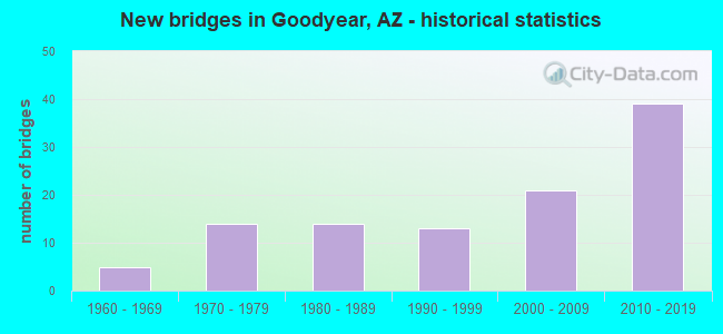
- New bridges - historical statistics
- 51960-1969
- 141970-1979
- 141980-1989
- 131990-1999
- 212000-2009
- 392010-2019
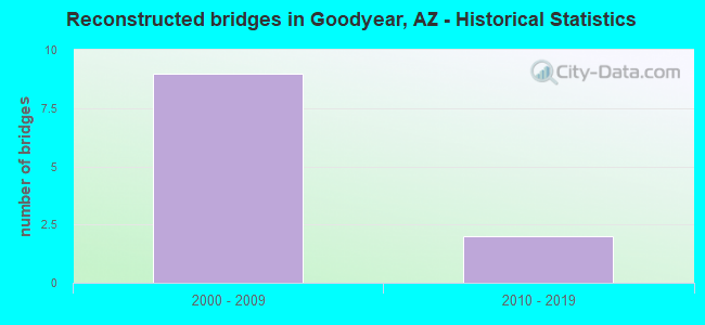
- Reconstructed bridges - Historical Statistics
- 92000-2009
- 22010-2019
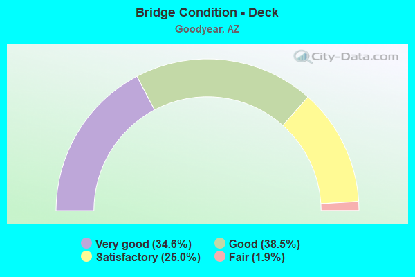
- Bridge Condition - Deck
- 34.6%Very good
- 38.5%Good
- 25.0%Satisfactory
- 1.9%Fair
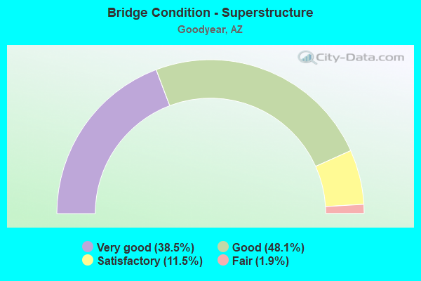
- Bridge Condition - Superstructure
- 38.5%Very good
- 48.1%Good
- 11.5%Satisfactory
- 1.9%Fair
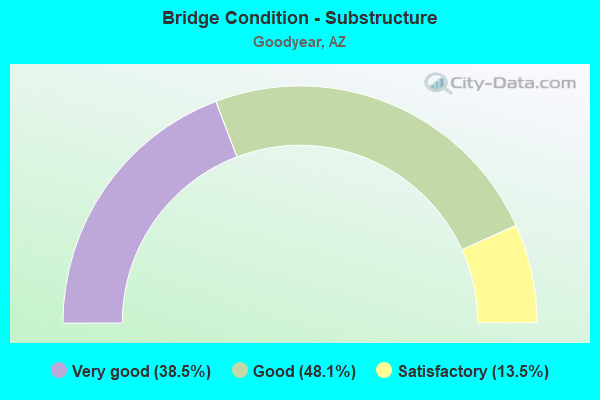
- Bridge Condition - Substructure
- 38.5%Very good
- 48.1%Good
- 13.5%Satisfactory
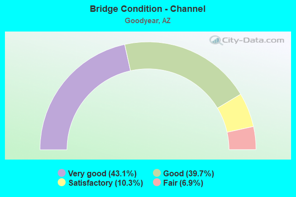
- Bridge Condition - Channel
- 43.1%Very good
- 39.7%Good
- 10.3%Satisfactory
- 6.9%Fair
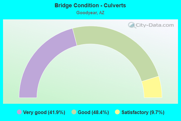
- Bridge Condition - Culverts
- 41.9%Very good
- 48.4%Good
- 9.7%Satisfactory
Find on map >> Show street view
Structure Number: 2978, Location: NE of Junct I10 & 303L (Lat: 33.464700, Lng: -112.425600), Route carried "under" structure: Ramp State highway 10, Year Built: 2014, Structure Length: 0. m, Average Daily Traffic: 3,000 (year 2017), Truck Traffic: 2%, Features Intersected: Ramp WN, Facility Carried by Structure: McDowell Rd
Minimum Vertical Clearance: 5.32m (17.45ft), Kilometerpoint: 200.798, Lanes on structure: 5, Lanes under structure: 2, Material/Design: Prestressed concrete, Design/Construction: Box Beam or Girders - Multiple, Length of Maximum Span: 30.5m (100.1ft)
Find on map >> Show street view
Structure Number: 2979, Location: 24.5 mi W Jct I 10/I 17 (Lat: 33.461500, Lng: -112.428600), Route carried "under" structure: State highway 303, Year Built: 2013, Structure Length: 0. m, Average Daily Traffic: 43,764 (year 2021), Truck Traffic: 6%, Features Intersected: SR303L Mainline & Frt R, Facility Carried by Structure: I-10 EB
Minimum Vertical Clearance: 7.01m (23.00ft), Kilometerpoint: 0.000, Lanes on structure: 5, Lanes under structure: 8, Material/Design: Prestressed concrete continuous, Design/Construction: Box Beam or Girders - Single/Spread, Length of Maximum Span: 39.6m (129.9ft)
Find on map >> Show street view
Structure Number: 298, Location: 24.5 mi W Jct I 10/I 17 (Lat: 33.462000, Lng: -112.428600), Route carried "under" structure: State highway 303, Year Built: 2013, Structure Length: 0. m, Average Daily Traffic: 43,764 (year 2021), Truck Traffic: 6%, Features Intersected: SR303L Mainline & Frt Rd, Facility Carried by Structure: I-10 WB
Minimum Vertical Clearance: 5.84m (19.16ft), Kilometerpoint: 0.000, Lanes on structure: 5, Lanes under structure: 8, Material/Design: Prestressed concrete continuous, Design/Construction: Box Beam or Girders - Single/Spread, Length of Maximum Span: 39.6m (129.9ft)
Find on map >> Show street view
Structure Number: 2981, Location: NE junct of I-10/303L (Lat: 33.463000, Lng: -112.429000), Route carried "under" structure: Ramp State highway 303, Year Built: 2014, Structure Length: 0. m, Average Daily Traffic: 3,000 (year 2019), Truck Traffic: 2%, Features Intersected: Ramp SW, Facility Carried by Structure: I-10 WB Frt Rd
Minimum Vertical Clearance: 5.40m (17.72ft), Kilometerpoint: 166.438, Lanes on structure: 2, Lanes under structure: 1, Material/Design: Prestressed concrete continuous, Design/Construction: Box Beam or Girders - Multiple, Length of Maximum Span: 48.8m (160.1ft)
Find on map >> Show street view
Structure Number: 2982, Location: N of Jct I-10 & 303L (Lat: 33.463900, Lng: -112.428700), Route carried "under" structure: Ramp Interstate 10, Year Built: 2014, Structure Length: 0. m, Average Daily Traffic: 2,000 (year 2021), Truck Traffic: 2%, Features Intersected: Ramp SW, Facility Carried by Structure: SR303L SB Frt RD
Minimum Vertical Clearance: 6.54m (21.46ft), Kilometerpoint: 200.540, Lanes on structure: 2, Lanes under structure: 1, Material/Design: Prestressed concrete continuous, Design/Construction: Box Beam or Girders - Multiple, Length of Maximum Span: 27.6m (90.6ft)
Find on map >> Show street view
Structure Number: 2983, Location: 26.5 mi W Jct I 10 Ramp (Lat: 33.460803, Lng: -112.432308), Route carried "under" structure: Interstate 10, Year Built: 2014, Structure Length: 0. m, Average Daily Traffic: 102,371 (year 2021), Truck Traffic: 13%, Features Intersected: 10, Facility Carried by Structure: Ramp EN
Minimum Vertical Clearance: 5.45m (17.88ft), Kilometerpoint: 200.701, Lanes on structure: 1, Lanes under structure: 2, Material/Design: Prestressed concrete continuous, Design/Construction: Box Beam or Girders - Multiple, Length of Maximum Span: 66.4m (217.8ft)
Find on map >> Show street view
Structure Number: 2984, Location: 26.5 mi W Jct I 10 & (Lat: 33.466000, Lng: -112.428000), Route carried "under" structure: _, Year Built: 2014, Structure Length: 0. m, Average Daily Traffic: 105,335 (year 2021), Truck Traffic: 13%, Features Intersected: 10, Facility Carried by Structure: Ramp SE
Minimum Vertical Clearance: 5.17m (16.96ft), Kilometerpoint: 0.000, Lanes on structure: 2, Lanes under structure: 17, Material/Design: Prestressed concrete continuous, Design/Construction: Box Beam or Girders - Multiple, Length of Maximum Span: 70.4m (231.0ft)
Find on map >> Show street view
Structure Number: 2985, Location: 0.13 mi N of I-10 (Lat: 33.464700, Lng: -112.428100), Route carried "under" structure: State highway 303, Year Built: 2013, Structure Length: 0. m, Average Daily Traffic: 43,808 (year 2019), Truck Traffic: 7%, Features Intersected: Loop 303, Facility Carried by Structure: McDowell Road
Minimum Vertical Clearance: 6.11m (20.05ft), Kilometerpoint: 167.597, Lanes on structure: 7, Lanes under structure: 3, Material/Design: Prestressed concrete continuous, Design/Construction: Box Beam or Girders - Single/Spread, Length of Maximum Span: 40.2m (131.9ft)
Find on map >> Show street view
Structure Number: 2986, Location: NE side of Jnc I-10/303L (Lat: 33.463200, Lng: -112.423700), Route carried "under" structure: Ramp State highway 10, Year Built: 2014, Structure Length: 0. m, Average Daily Traffic: 3,000 (year 2017), Truck Traffic: 2%, Features Intersected: Ramp WN
Minimum Vertical Clearance: 5.25m (17.22ft), Kilometerpoint: 200.943, Lanes on structure: 2, Lanes under structure: 2, Material/Design: Prestressed concrete, Design/Construction: Box Beam or Girders - Multiple, Length of Maximum Span: 50.3m (165.0ft)
Find on map >> Show street view
Structure Number: 20016, Location: 2.3 mi N of I-10 (Lat: 33.493400, Lng: -112.420600), Route carried "under" structure: City street , Year Built: 2013, Structure Length: 0. m, Average Daily Traffic: 6,268 (year 2017), Truck Traffic: 5%, Features Intersected: Indian School Road, Facility Carried by Structure: SR 303L
Minimum Vertical Clearance: 5.25m (17.22ft), Kilometerpoint: 0.000, Lanes on structure: 6, Lanes under structure: 8, Material/Design: Prestressed concrete continuous, Design/Construction: Stringer/Multi-beam, Length of Maximum Span: 34.1m (111.9ft)
Find on map >> Show street view
Structure Number: 20069, Location: At Junct of I-10/303L (Lat: 33.459300, Lng: -112.427300), Route carried "under" structure: Interstate 10, Year Built: 2017, Structure Length: 0. m, Average Daily Traffic: 137,972 (year 2018), Truck Traffic: 4%, Features Intersected: I-10, Facility Carried by Structure: Ramp NW
Minimum Vertical Clearance: 5.41m (17.75ft), Kilometerpoint: 200.524, Lanes on structure: 2, Lanes under structure: 10, Material/Design: Prestressed concrete continuous, Design/Construction: Box Beam or Girders - Multiple, Length of Maximum Span: 71.6m (234.9ft)
Find on map >> Show street view
Structure Number: 2007, Location: At Junct of I-10/303L (Lat: 33.463000, Lng: -112.421500), Route carried "under" structure: Ramp State highway 303, Year Built: 2017, Structure Length: 0. m, Average Daily Traffic: 13,054 (year 2018), Truck Traffic: 4%, Features Intersected: I-10, Facility Carried by Structure: Ramp WS
Minimum Vertical Clearance: 5.85m (19.19ft), Kilometerpoint: 165.988, Lanes on structure: 2, Lanes under structure: 16, Material/Design: Prestressed concrete continuous, Design/Construction: Box Beam or Girders - Multiple, Length of Maximum Span: 70.1m (230.0ft)
Find on map >> Show street view
Structure Number: 20104, Location: 0.80 mi S of I-10 (Lat: 33.449900, Lng: -112.427100), Route carried "under" structure: City street , Year Built: 2017, Structure Length: 0. m, Average Daily Traffic: 6,097 (year 2020), Truck Traffic: 5%, Features Intersected: Van Buren Rd, Facility Carried by Structure: SR 303L
Minimum Vertical Clearance: 5.30m (17.39ft), Kilometerpoint: 0.000, Lanes on structure: 4, Lanes under structure: 8, Material/Design: Prestressed concrete continuous, Design/Construction: Box Beam or Girders - Single/Spread, Length of Maximum Span: 26.4m (86.6ft)
Find on map >> Show street view
Structure Number: 20105, Location: S side Jnc I-10/303L (Lat: 33.460300, Lng: -112.429600), Route carried "under" structure: ServiceState highway 303, Year Built: 2017, Structure Length: 0. m, Average Daily Traffic: 6,527 (year 2018), Truck Traffic: 4%, Features Intersected: I-10 EB-SR303L WB Frt Rd, Facility Carried by Structure: I-10-Ramp ES
Minimum Vertical Clearance: 5.80m (19.03ft), Kilometerpoint: 166.438, Lanes on structure: 2, Lanes under structure: 4, Material/Design: Prestressed concrete continuous, Design/Construction: Box Beam or Girders - Multiple, Length of Maximum Span: 45.7m (149.9ft)
Find on map >> Show street view
Structure Number: 20106, Location: 0.92 mi E of Citrus Rd (Lat: 33.460100, Lng: -112.428300), Route carried "under" structure: State highway 303, Year Built: 2017, Structure Length: 0. m, Average Daily Traffic: 6,301 (year 2020), Truck Traffic: 5%, Features Intersected: SR303L, Facility Carried by Structure: I-10 EB Frt Rd
Minimum Vertical Clearance: 5.27m (17.29ft), Kilometerpoint: 0.000, Lanes on structure: 2, Lanes under structure: 2, Material/Design: Prestressed concrete continuous, Design/Construction: Box Beam or Girders - Single/Spread, Length of Maximum Span: 31.7m (104.0ft)
Find on map >> Show street view
Structure Number: 20107, Location: N of Jnc I-10 & 303L (Lat: 33.463000, Lng: -112.427300), Route carried "under" structure: State highway 303, Year Built: 2016, Structure Length: 0. m, Average Daily Traffic: 32,637 (year 2018), Truck Traffic: 7%, Features Intersected: SR303L, Facility Carried by Structure: I-10 WB Frt Rd
Minimum Vertical Clearance: 5.81m (19.06ft), Kilometerpoint: 166.438, Lanes on structure: 2, Lanes under structure: 2, Material/Design: Prestressed concrete continuous, Design/Construction: Box Beam or Girders - Multiple, Length of Maximum Span: 35.1m (115.2ft)
Find on map >> Show street view
Structure Number: 20108, Location: S Junct of I10/303L (Lat: 33.459000, Lng: -112.427000), Route carried "under" structure: ServiceState highway 303, Year Built: 2017, Structure Length: 0. m, Average Daily Traffic: 55,800 (year 2020), Truck Traffic: 12%, Features Intersected: I-10 EB-SR303L SB Frt Rd, Facility Carried by Structure: I-10-Ramp NE
Minimum Vertical Clearance: 7.04m (23.10ft), Kilometerpoint: 165.988, Lanes on structure: 2, Lanes under structure: 5, Material/Design: Prestressed concrete continuous, Design/Construction: Box Beam or Girders - Multiple, Length of Maximum Span: 42.7m (140.1ft)