Bridge Statistics for Goodyear, Arizona (AZ)
Condition, Traffic, Stress, Structural Evaluation, Project Costs
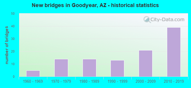
- New bridges - historical statistics
- 51960-1969
- 141970-1979
- 141980-1989
- 131990-1999
- 212000-2009
- 392010-2019
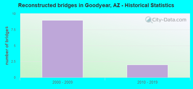
- Reconstructed bridges - Historical Statistics
- 92000-2009
- 22010-2019
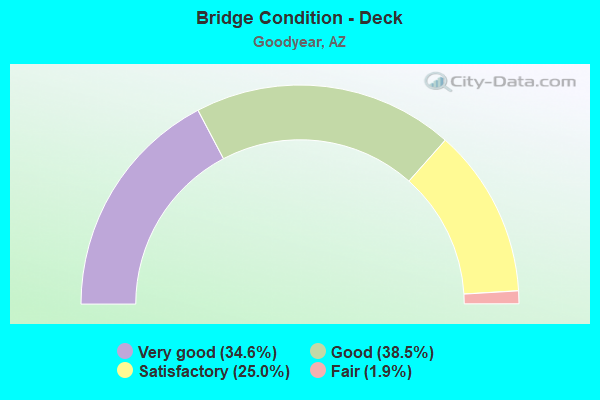
- Bridge Condition - Deck
- 34.6%Very good
- 38.5%Good
- 25.0%Satisfactory
- 1.9%Fair
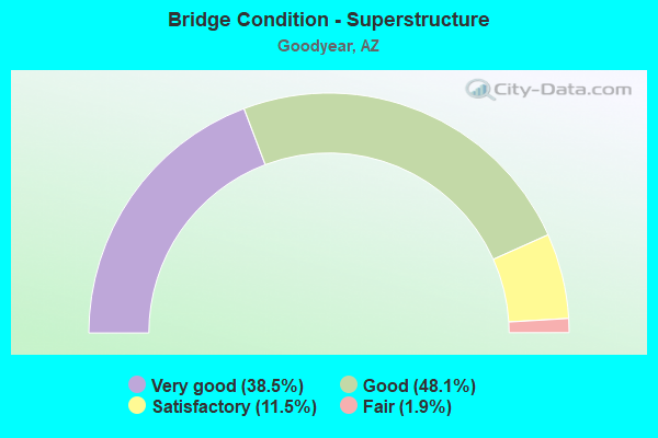
- Bridge Condition - Superstructure
- 38.5%Very good
- 48.1%Good
- 11.5%Satisfactory
- 1.9%Fair
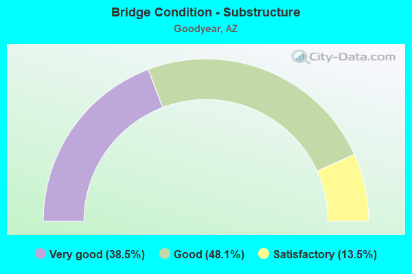
- Bridge Condition - Substructure
- 38.5%Very good
- 48.1%Good
- 13.5%Satisfactory
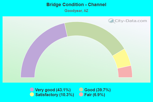
- Bridge Condition - Channel
- 43.1%Very good
- 39.7%Good
- 10.3%Satisfactory
- 6.9%Fair
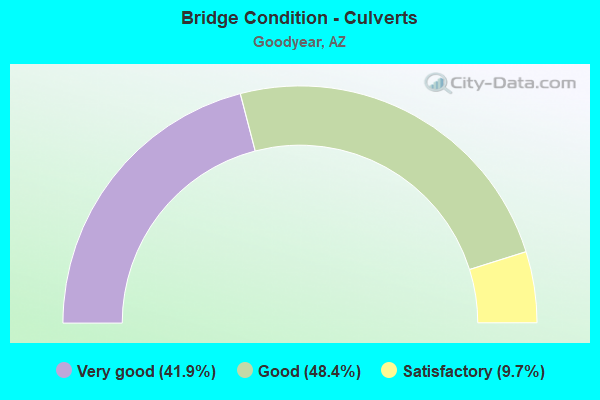
- Bridge Condition - Culverts
- 41.9%Very good
- 48.4%Good
- 9.7%Satisfactory
Find on map >> Show street view
Structure Number: 1063, Location: AT JCT SR 84 (Lat: 32.834200, Lng: -112.133400), Route carried "on" structure: State highway 84, Year Built: 1962, Status: Open, Structure Length: 8.96m (29.40ft), Average Daily Traffic: 2,013 (year 2018), Truck Traffic: 10%, Average Future Daily Traffic: 2,023 (year 2038), Design Load: HS 20, Features Intersected: I 8
Minimum Vertical Clearance: 30+ m (98+ ft), Kilometerpoint: 249.802, Lanes on structure: 2, Lanes under structure: 4, Owner: State Highway Agency, Approaching Roadway Width: 9.8m (32.2ft), Skew: 3 degrees, Material/Design: Steel continuous, Design/Construction: Stringer/Multi-beam, Number Of Spans In Main Unit: 4, Length of Maximum Span: 27.4m (89.9ft), Curb-To-Curb Width: 9.7m (31.8ft), Out-to-Out Width: 10.7m (35.1ft)
Condition: Deck: Fair, Superstructure: Good, Substructure: Satisfactory, Operating Rating: 55.3 metric tons, Method Used To Determine Operating Rating: Load Factor (LF), Inventory Rating: 32.7 metric tons, Method Used To Determine Inventory Rating: Load Factor (LF), Structural Evaluation: Equal to present minimum criteria, Deck Geometry: Meets minimum limits, Underclear: High priority of corrective action, Approach Roadway Alignment: Equal to present minimum criteria, Designated Inspection Frequency: Every 24 months, Inspection Date: October 2021, Deck Structure Type: Concrete Cast-file-Place, Wearing Surface/Protective System: Wearing Surface: Monolithic Concrete
Find on map >> Show street view
Structure Number: 1093, Location: 11.3 mi E Jct SR 84 (Lat: 32.828367, Lng: -111.938211), Route carried "on" structure: Interstate 8, Year Built: 1965, Status: Open, Structure Length: 18.90m (62.01ft), Average Daily Traffic: 3,766 (year 2018), Truck Traffic: 19%, Average Future Daily Traffic: 3,776 (year 2038), Design Load: HS 20, Features Intersected: Santa Rosa Wash
Minimum Vertical Clearance: 30+ m (98+ ft), Kilometerpoint: 262.323, Lanes on structure: 2, Owner: State Highway Agency, Approaching Roadway Width: 9.8m (32.2ft), Material/Design: Concrete continuous, Design/Construction: Slab, Number Of Spans In Main Unit: 18, Length of Maximum Span: 10.7m (35.1ft), Curb-To-Curb Width: 9.8m (32.2ft), Out-to-Out Width: 10.7m (35.1ft)
Condition: Deck: Satisfactory, Superstructure: Satisfactory, Substructure: Satisfactory, Channel: Satisfactory, Operating Rating: 59.0 metric tons, Method Used To Determine Operating Rating: Load Factor (LF), Inventory Rating: 35.4 metric tons, Method Used To Determine Inventory Rating: Load Factor (LF), Structural Evaluation: Equal to present minimum criteria, Deck Geometry: Meets minimum limits, Waterway Adequacy: Better than present minimum criteria, Approach Roadway Alignment: Equal to present desirable criteria, Designated Inspection Frequency: Every 24 months, Inspection Date: Febuary 2022, Deck Structure Type: Concrete Cast-file-Place, Wearing Surface/Protective System: Wearing Surface: Bituminous
Find on map >> Show street view
Structure Number: 1148, Location: 12.6 mi S of Jct US 60 (Lat: 33.219200, Lng: -111.920700), Route carried "on" structure: County highway , Year Built: 1967, Status: Open, Structure Length: 9.17m (30.09ft), Average Daily Traffic: 24,577 (year 2018), Truck Traffic: 5%, Average Future Daily Traffic: 24,587 (year 2038), Design Load: HS 20, Features Intersected: I 10; EB & WB, Facility Carried by Structure: IRR Riggs Road
Minimum Vertical Clearance: 30+ m (98+ ft), Kilometerpoint: 0.000, Lanes on structure: 2, Lanes under structure: 4, Owner: State Highway Agency, Approaching Roadway Width: 7.9m (25.9ft), Skew: 3 degrees, Material/Design: Steel continuous, Design/Construction: Stringer/Multi-beam, Number Of Spans In Main Unit: 4, Length of Maximum Span: 28.3m (92.8ft), Curb or Sidewalk Widths: Left: 0.5m (1.6ft), Right: 0.5m (1.6ft), Curb-To-Curb Width: 7.9m (25.9ft), Out-to-Out Width: 9.5m (31.2ft)
Condition: Deck: Satisfactory, Superstructure: Fair, Substructure: Good, Operating Rating: 66.2 metric tons, Method Used To Determine Operating Rating: Load Factor (LF), Inventory Rating: 39.9 metric tons, Method Used To Determine Inventory Rating: Load Factor (LF), Structural Evaluation: Somewhat better than minimum adequacy, Deck Geometry: High priority of corrective action, Underclear: Meets minimum limits, Approach Roadway Alignment: Equal to present desirable criteria, Length Of Structure Improvement: 10.18m (33.40ft), Designated Inspection Frequency: Every 24 months, Inspection Date: May 2021, Bridge Improvement Cost: $1,000, Total Project Cost: $1,000 ( Estimate for 2019), Deck Structure Type: Concrete Cast-file-Place, Wearing Surface/Protective System: Wearing Surface: Monolithic Concrete
Find on map >> Show street view
Structure Number: 1707, Location: 25.5 mi W Jct I 10 (Lat: 33.461500, Lng: -112.444400), Route carried "on" structure: Interstate 10, Year Built: 1978, Year Reconstructed: 2010, Status: Open, Structure Length: 3.93m (12.89ft), Average Daily Traffic: 110,900 (year 2019), Truck Traffic: 13%, Average Future Daily Traffic: 133,249 (year 2039), Design Load: HS 20, Features Intersected: Citrus Rd
Minimum Vertical Clearance: 30+ m (98+ ft), Kilometerpoint: 199.060, Lanes on structure: 7, Lanes under structure: 5, Owner: State Highway Agency, Approaching Roadway Width: 46.3m (151.9ft), Skew: 30 degrees, Material/Design: Prestressed concrete, Design/Construction: Box Beam or Girders - Single/Spread, Number Of Spans In Main Unit: 1, Length of Maximum Span: 38.4m (126.0ft), Curb-To-Curb Width: 46.5m (152.6ft), Out-to-Out Width: 48.3m (158.5ft)
Condition: Deck: Good, Superstructure: Good, Substructure: Good, Operating Rating: 68.9 metric tons, Method Used To Determine Operating Rating: Load Factor (LF), Inventory Rating: 39.0 metric tons, Method Used To Determine Inventory Rating: Load Factor (LF), Structural Evaluation: Better than present minimum criteria, Deck Geometry: Superior to present desirable criteria, Underclear: Better than present minimum criteria, Approach Roadway Alignment: Equal to present desirable criteria, Designated Inspection Frequency: Every 24 months, Inspection Date: January 2021, Deck Structure Type: Concrete Cast-file-Place, Wearing Surface/Protective System: Wearing Surface: Bituminous
Find on map >> Show street view
Structure Number: 1715, Location: 22.5 mi W Jct I 10/I 17 (Lat: 33.461300, Lng: -112.392800), Route carried "on" structure: Interstate 10, Year Built: 1978, Year Reconstructed: 2011, Status: Open, Structure Length: 4.66m (15.29ft), Average Daily Traffic: 151,675 (year 2019), Truck Traffic: 11%, Average Future Daily Traffic: 151,685 (year 2039), Design Load: HS 20, Features Intersected: Estrella Pkwy
Minimum Vertical Clearance: 30+ m (98+ ft), Kilometerpoint: 203.856, Lanes on structure: 10, Lanes under structure: 6, Owner: State Highway Agency, Approaching Roadway Width: 67.7m (222.1ft), Skew: 30 degrees, Material/Design: Prestressed concrete, Design/Construction: Box Beam or Girders - Single/Spread, Number Of Spans In Main Unit: 1, Length of Maximum Span: 45.7m (149.9ft), Curb-To-Curb Width: 67.9m (222.8ft), Out-to-Out Width: 69.7m (228.7ft)
Condition: Deck: Good, Superstructure: Good, Substructure: Good, Operating Rating: 85.3 metric tons, Method Used To Determine Operating Rating: Load Factor (LF), Inventory Rating: 46.3 metric tons, Method Used To Determine Inventory Rating: Load Factor (LF), Structural Evaluation: Better than present minimum criteria, Deck Geometry: Superior to present desirable criteria, Underclear: High priority of corrective action, Approach Roadway Alignment: Equal to present desirable criteria, Designated Inspection Frequency: Every 24 months, Inspection Date: Febuary 2021, Deck Structure Type: Concrete Cast-file-Place, Wearing Surface/Protective System: Wearing Surface: Bituminous
Find on map >> Show street view
Structure Number: 1717, Location: 21.5 mi W Jct I 10/I 17 (Lat: 33.460400, Lng: -112.375800), Route carried "on" structure: Interstate 10, Year Built: 1978, Year Reconstructed: 2011, Status: Open, Structure Length: 4.30m (14.11ft), Average Daily Traffic: 151,675 (year 2019), Truck Traffic: 11%, Average Future Daily Traffic: 151,685 (year 2039), Design Load: HS 20, Features Intersected: Bullard Ave OP
Minimum Vertical Clearance: 30+ m (98+ ft), Kilometerpoint: 205.465, Lanes on structure: 10, Lanes under structure: 8, Owner: State Highway Agency, Approaching Roadway Width: 60.7m (199.1ft), Skew: 31 degrees, Material/Design: Prestressed concrete, Design/Construction: Box Beam or Girders - Single/Spread, Number Of Spans In Main Unit: 1, Length of Maximum Span: 42.1m (138.1ft), Curb-To-Curb Width: 60.6m (198.8ft), Out-to-Out Width: 62.4m (204.7ft)
Condition: Deck: Good, Superstructure: Good, Substructure: Good, Operating Rating: 76.2 metric tons, Method Used To Determine Operating Rating: Load Factor (LF), Inventory Rating: 41.7 metric tons, Method Used To Determine Inventory Rating: Load Factor (LF), Structural Evaluation: Better than present minimum criteria, Deck Geometry: Superior to present desirable criteria, Underclear: Meets minimum limits, Waterway Adequacy: Equal to present desirable criteria, Approach Roadway Alignment: Equal to present desirable criteria, Designated Inspection Frequency: Every 24 months, Inspection Date: Febuary 2021, Deck Structure Type: Concrete Cast-file-Place, Wearing Surface/Protective System: Wearing Surface: Bituminous
Find on map >> Show street view
Structure Number: 1719, Location: 20.8 mi W Jct I 10/I 17 (Lat: 33.458000, Lng: -112.362800), Route carried "on" structure: Interstate 10, Year Built: 1978, Year Reconstructed: 2011, Status: Open, Structure Length: 4.18m (13.71ft), Average Daily Traffic: 197,108 (year 2019), Truck Traffic: 11%, Average Future Daily Traffic: 197,118 (year 2039), Design Load: HS 20, Features Intersected: Dirt/Gravel Road
Minimum Vertical Clearance: 30+ m (98+ ft), Kilometerpoint: 206.720, Lanes on structure: 12, Owner: State Highway Agency, Approaching Roadway Width: 76.8m (252.0ft), Skew: 30 degrees, Material/Design: Prestressed concrete continuous, Design/Construction: Stringer/Multi-beam, Number Of Spans In Main Unit: 3, Length of Maximum Span: 16.5m (54.1ft), Curb-To-Curb Width: 76.7m (251.6ft), Out-to-Out Width: 78.5m (257.5ft)
Condition: Deck: Good, Superstructure: Very good, Substructure: Satisfactory, Operating Rating: 79.8 metric tons, Method Used To Determine Operating Rating: Load Factor (LF), Inventory Rating: 36.3 metric tons, Method Used To Determine Inventory Rating: Load Factor (LF), Structural Evaluation: Equal to present minimum criteria, Deck Geometry: Superior to present desirable criteria, Approach Roadway Alignment: Equal to present desirable criteria, Designated Inspection Frequency: Every 24 months, Inspection Date: Febuary 2021, Deck Structure Type: Concrete Cast-file-Place, Wearing Surface/Protective System: Wearing Surface: Bituminous
Find on map >> Show street view
Structure Number: 1721, Location: 20.5 mi W Jct I 10/I 17 (Lat: 33.457900, Lng: -112.358500), Route carried "on" structure: Interstate 10, Year Built: 1978, Year Reconstructed: 2011, Status: Open, Structure Length: 4.97m (16.31ft), Average Daily Traffic: 197,108 (year 2019), Truck Traffic: 11%, Average Future Daily Traffic: 197,118 (year 2039), Design Load: HS 20, Features Intersected: Litchfield Road
Minimum Vertical Clearance: 30+ m (98+ ft), Kilometerpoint: 207.090, Lanes on structure: 10, Lanes under structure: 9, Owner: State Highway Agency, Approaching Roadway Width: 60.7m (199.1ft), Skew: 30 degrees, Material/Design: Prestressed concrete, Design/Construction: Box Beam or Girders - Single/Spread, Number Of Spans In Main Unit: 1, Length of Maximum Span: 48.8m (160.1ft), Curb-To-Curb Width: 60.6m (198.8ft), Out-to-Out Width: 62.4m (204.7ft)
Condition: Deck: Good, Superstructure: Good, Substructure: Good, Operating Rating: 78.9 metric tons, Method Used To Determine Operating Rating: Load Factor (LF), Inventory Rating: 39.0 metric tons, Method Used To Determine Inventory Rating: Load Factor (LF), Structural Evaluation: Better than present minimum criteria, Deck Geometry: Superior to present desirable criteria, Underclear: Meets minimum limits, Approach Roadway Alignment: Equal to present desirable criteria, Designated Inspection Frequency: Every 24 months, Inspection Date: Febuary 2021, Deck Structure Type: Concrete Cast-file-Place, Wearing Surface/Protective System: Wearing Surface: Bituminous
Find on map >> Show street view
Structure Number: 2084, Location: 22.1 mi W Jct I 10/I 17 (Lat: 33.461269, Lng: -112.384272), Route carried "on" structure: Interstate 10, Year Built: 2009, Status: Open, Structure Length: 3.60m (11.81ft), Average Daily Traffic: 151,675 (year 2019), Truck Traffic: 11%, Average Future Daily Traffic: 151,685 (year 2039), Design Load: HS 25 or greater, Features Intersected: Bullard Wash
Minimum Vertical Clearance: 30+ m (98+ ft), Kilometerpoint: 204.660, Lanes on structure: 12, Owner: State Highway Agency, Approaching Roadway Width: 75.3m (247.0ft), Skew: 31 degrees, Material/Design: Concrete, Design/Construction: Slab, Number Of Spans In Main Unit: 3, Length of Maximum Span: 13.4m (44.0ft), Curb-To-Curb Width: 75.2m (246.7ft), Out-to-Out Width: 77.1m (253.0ft)
Condition: Deck: Very good, Superstructure: Very good, Substructure: Very good, Channel: Very good, Operating Rating: 89.8 metric tons, Method Used To Determine Operating Rating: Load Factor (LF), Inventory Rating: 58.1 metric tons, Method Used To Determine Inventory Rating: Load Factor (LF), Structural Evaluation: Equal to present desirable criteria, Deck Geometry: Superior to present desirable criteria, Waterway Adequacy: Equal to present desirable criteria, Approach Roadway Alignment: Superior to present desirable criteria, Designated Inspection Frequency: Every 24 months, Inspection Date: Febuary 2021, Deck Structure Type: Concrete Cast-file-Place, Wearing Surface/Protective System: Wearing Surface: Bituminous
Find on map >> Show street view
Structure Number: 2085, Location: 19.2 mi W Jct SR 347 (Lat: 33.029922, Lng: -112.365936), Route carried "on" structure: State highway 238, Year Built: 1988, Status: Open, Structure Length: 5.06m (16.60ft), Average Daily Traffic: 2,987 (year 2019), Truck Traffic: 16%, Average Future Daily Traffic: 2,997 (year 2039), Design Load: HS 20, Features Intersected: Waterman Wash
Minimum Vertical Clearance: 30+ m (98+ ft), Kilometerpoint: 40.314, Lanes on structure: 2, Owner: State Highway Agency, Approaching Roadway Width: 8.5m (27.9ft), Skew: 2 degrees, Material/Design: Concrete continuous, Design/Construction: Slab, Number Of Spans In Main Unit: 5, Length of Maximum Span: 10.7m (35.1ft), Curb-To-Curb Width: 9.8m (32.2ft), Out-to-Out Width: 10.7m (35.1ft)
Condition: Deck: Good, Superstructure: Good, Substructure: Very good, Channel: Good, Operating Rating: 89.8 metric tons, Method Used To Determine Operating Rating: Load Factor (LF), Inventory Rating: 59.0 metric tons, Method Used To Determine Inventory Rating: Load Factor (LF), Structural Evaluation: Better than present minimum criteria, Deck Geometry: Meets minimum limits, Waterway Adequacy: Equal to present desirable criteria, Approach Roadway Alignment: Equal to present desirable criteria, Designated Inspection Frequency: Every 24 months, Inspection Date: April 2020, Deck Structure Type: Concrete Cast-file-Place, Wearing Surface/Protective System: Wearing Surface: Monolithic Concrete
Find on map >> Show street view
Structure Number: 2977, Location: 1.15 mi N I-10 (Lat: 33.479800, Lng: -112.424300), Route carried "on" structure: City street , Year Built: 2014, Status: Open, Structure Length: 9.48m (31.10ft), Average Daily Traffic: 2,058 (year 2019), Truck Traffic: 5%, Average Future Daily Traffic: 2,068 (year 2039), Design Load: HL 93, Features Intersected: 303L NB & SB, Facility Carried by Structure: Thomas Road
Minimum Vertical Clearance: 30+ m (98+ ft), Kilometerpoint: 0.000, Lanes on structure: 1, Lanes under structure: 6, Owner: State Highway Agency, Approaching Roadway Width: 9.8m (32.2ft), Material/Design: Prestressed concrete continuous, Design/Construction: Box Beam or Girders - Single/Spread, Number Of Spans In Main Unit: 2, Length of Maximum Span: 50.3m (165.0ft), Curb-To-Curb Width: 9.8m (32.2ft), Out-to-Out Width: 10.7m (35.1ft)
Condition: Deck: Very good, Superstructure: Very good, Substructure: Very good, Operating Rating: 89.8 metric tons, Method Used To Determine Operating Rating: Load Factor (LF), Inventory Rating: 60.8 metric tons, Method Used To Determine Inventory Rating: Load Factor (LF), Structural Evaluation: Equal to present desirable criteria, Deck Geometry: Meets minimum limits, Underclear: Better than present minimum criteria, Approach Roadway Alignment: Equal to present desirable criteria, Designated Inspection Frequency: Every 24 months, Inspection Date: July 2020, Deck Structure Type: Concrete Cast-file-Place, Wearing Surface/Protective System: Wearing Surface: Monolithic Concrete
Find on map >> Show street view
Structure Number: 2978, Location: NE of Junct I10 & 303L (Lat: 33.464700, Lng: -112.425600), Route carried "on" structure: Ramp City street , Year Built: 2014, Status: Open, Structure Length: 3.23m (10.60ft), Average Daily Traffic: 6,584 (year 2018), Truck Traffic: 2%, Average Future Daily Traffic: 6,594 (year 2038), Design Load: HL 93, Features Intersected: Ramp WN, Facility Carried by Structure: McDowell Rd
Minimum Vertical Clearance: 11.93m (39.14ft), Kilometerpoint: 0.000, Lanes on structure: 5, Lanes under structure: 2, Owner: State Highway Agency, Approaching Roadway Width: 26.2m (86.0ft), Skew: 22 degrees, Material/Design: Prestressed concrete, Design/Construction: Box Beam or Girders - Multiple, Number Of Spans In Main Unit: 1, Length of Maximum Span: 30.5m (100.1ft), Curb or Sidewalk Widths: Left: 1.8m (5.9ft), Right: 1.8m (5.9ft), Curb-To-Curb Width: 30.5m (100.1ft), Out-to-Out Width: 34.9m (114.5ft)
Condition: Deck: Very good, Superstructure: Very good, Substructure: Very good, Operating Rating: 89.8 metric tons, Method Used To Determine Operating Rating: Load Factor (LF), Inventory Rating: 56.2 metric tons, Method Used To Determine Inventory Rating: Load Factor (LF), Structural Evaluation: Equal to present desirable criteria, Deck Geometry: Superior to present desirable criteria, Underclear: Equal to present desirable criteria, Approach Roadway Alignment: Equal to present minimum criteria, Designated Inspection Frequency: Every 24 months, Inspection Date: October 2021, Deck Structure Type: Concrete Cast-file-Place, Wearing Surface/Protective System: Wearing Surface: Monolithic Concrete
Find on map >> Show street view
Structure Number: 2979, Location: 24.5 mi W Jct I 10/I 17 (Lat: 33.461500, Lng: -112.428600), Route carried "on" structure: Interstate 10, Year Built: 2013, Status: Open, Structure Length: 14.20m (46.59ft), Average Daily Traffic: 53,959 (year 2021), Truck Traffic: 13%, Average Future Daily Traffic: 53,969 (year 2041), Design Load: HL 93, Features Intersected: SR303L Mainline & Frt R
Minimum Vertical Clearance: 5.03m (16.50ft), Kilometerpoint: 200.669, Lanes on structure: 5, Lanes under structure: 8, Owner: State Highway Agency, Approaching Roadway Width: 26.8m (87.9ft), Material/Design: Prestressed concrete continuous, Design/Construction: Box Beam or Girders - Single/Spread, Number Of Spans In Main Unit: 4, Length of Maximum Span: 39.6m (129.9ft), Curb-To-Curb Width: 26.8m (87.9ft), Out-to-Out Width: 27.8m (91.2ft)
Condition: Deck: Very good, Superstructure: Very good, Substructure: Good, Operating Rating: 89.8 metric tons, Method Used To Determine Operating Rating: Load Factor (LF), Inventory Rating: 38.1 metric tons, Method Used To Determine Inventory Rating: Load Factor (LF), Structural Evaluation: Better than present minimum criteria, Deck Geometry: Somewhat better than minimum adequacy, Underclear: High priority of corrective action, Approach Roadway Alignment: Equal to present desirable criteria, Designated Inspection Frequency: Every 24 months, Inspection Date: January 2021, Deck Structure Type: Concrete Cast-file-Place, Wearing Surface/Protective System: Wearing Surface: Monolithic Concrete
Find on map >> Show street view
Structure Number: 298, Location: 24.5 mi W Jct I 10/I 17 (Lat: 33.462000, Lng: -112.428600), Route carried "on" structure: Interstate 10, Year Built: 2013, Status: Open, Structure Length: 14.20m (46.59ft), Average Daily Traffic: 54,319 (year 2021), Truck Traffic: 4%, Average Future Daily Traffic: 54,329 (year 2041), Design Load: HL 93, Features Intersected: SR303L Mainline & Frt Rd
Minimum Vertical Clearance: 5.78m (18.96ft), Kilometerpoint: 200.669, Lanes on structure: 5, Lanes under structure: 8, Owner: State Highway Agency, Approaching Roadway Width: 26.8m (87.9ft), Material/Design: Prestressed concrete continuous, Design/Construction: Box Beam or Girders - Single/Spread, Number Of Spans In Main Unit: 4, Length of Maximum Span: 39.6m (129.9ft), Curb-To-Curb Width: 26.8m (87.9ft), Out-to-Out Width: 27.8m (91.2ft)
Condition: Deck: Very good, Superstructure: Very good, Substructure: Good, Operating Rating: 89.8 metric tons, Method Used To Determine Operating Rating: Load Factor (LF), Inventory Rating: 38.1 metric tons, Method Used To Determine Inventory Rating: Load Factor (LF), Structural Evaluation: Better than present minimum criteria, Deck Geometry: Superior to present desirable criteria, Underclear: High priority of corrective action, Approach Roadway Alignment: Equal to present desirable criteria, Designated Inspection Frequency: Every 24 months, Inspection Date: January 2021, Deck Structure Type: Concrete Cast-file-Place, Wearing Surface/Protective System: Wearing Surface: Monolithic Concrete
Find on map >> Show street view
Structure Number: 2981, Location: NE junct of I-10/303L (Lat: 33.463000, Lng: -112.429000), Route carried "on" structure: ServiceState highway 10, Year Built: 2014, Status: Open, Structure Length: 10.85m (35.60ft), Average Daily Traffic: 1,008 (year 2019), Truck Traffic: 2%, Average Future Daily Traffic: 1,018 (year 2039), Design Load: HL 93, Features Intersected: Ramp SW
Minimum Vertical Clearance: 30+ m (98+ ft), Kilometerpoint: 200.396, Lanes on structure: 2, Lanes under structure: 1, Owner: State Highway Agency, Approaching Roadway Width: 10.4m (34.1ft), Skew: 3 degrees, Material/Design: Prestressed concrete continuous, Design/Construction: Box Beam or Girders - Multiple, Number Of Spans In Main Unit: 3, Length of Maximum Span: 48.8m (160.1ft), Curb-To-Curb Width: 10.4m (34.1ft), Out-to-Out Width: 11.3m (37.1ft)
Condition: Deck: Very good, Superstructure: Very good, Substructure: Very good, Operating Rating: 89.8 metric tons, Method Used To Determine Operating Rating: Load Factor (LF), Inventory Rating: 65.3 metric tons, Method Used To Determine Inventory Rating: Load Factor (LF), Structural Evaluation: Equal to present desirable criteria, Deck Geometry: Somewhat better than minimum adequacy, Underclear: Superior to present desirable criteria, Approach Roadway Alignment: Equal to present minimum criteria, Designated Inspection Frequency: Every 24 months, Inspection Date: October 2021, Deck Structure Type: Concrete Cast-file-Place, Wearing Surface/Protective System: Wearing Surface: Monolithic Concrete
Find on map >> Show street view
Structure Number: 2982, Location: N of Jct I-10 & 303L (Lat: 33.463900, Lng: -112.428700), Route carried "on" structure: ServiceState highway 303, Year Built: 2014, Status: Open, Structure Length: 6.24m (20.47ft), Average Daily Traffic: 10,000 (year 2021), Truck Traffic: 4%, Average Future Daily Traffic: 10,010 (year 2041), Design Load: HL 93, Features Intersected: Ramp SW
Minimum Vertical Clearance: 30+ m (98+ ft), Kilometerpoint: 167.372, Lanes on structure: 2, Lanes under structure: 1, Owner: State Highway Agency, Approaching Roadway Width: 10.4m (34.1ft), Skew: 2 degrees, Material/Design: Prestressed concrete continuous, Design/Construction: Box Beam or Girders - Multiple, Number Of Spans In Main Unit: 3, Length of Maximum Span: 27.6m (90.6ft), Curb-To-Curb Width: 10.4m (34.1ft), Out-to-Out Width: 11.3m (37.1ft)
Condition: Deck: Very good, Superstructure: Very good, Substructure: Very good, Operating Rating: 89.8 metric tons, Method Used To Determine Operating Rating: Load Factor (LF), Inventory Rating: 48.1 metric tons, Method Used To Determine Inventory Rating: Load Factor (LF), Structural Evaluation: Equal to present desirable criteria, Deck Geometry: Somewhat better than minimum adequacy, Underclear: Equal to present desirable criteria, Approach Roadway Alignment: Equal to present desirable criteria, Designated Inspection Frequency: Every 24 months, Inspection Date: January 2021, Deck Structure Type: Concrete Cast-file-Place, Wearing Surface/Protective System: Wearing Surface: Monolithic Concrete
Find on map >> Show street view
Structure Number: 2983, Location: 26.5 mi W Jct I 10 Ramp (Lat: 33.460803, Lng: -112.432308), Route carried "on" structure: Ramp Interstate 303, Year Built: 2014, Status: Open, Structure Length: 104.00m (341.21ft), Average Daily Traffic: 10,000 (year 2021), Truck Traffic: 2%, Average Future Daily Traffic: 10,010 (year 2041), Design Load: HL 93, Features Intersected: 10, Facility Carried by Structure: Ramp EN
Minimum Vertical Clearance: 30.18m (99.02ft), Kilometerpoint: 167.372, Lanes on structure: 1, Lanes under structure: 11, Owner: State Highway Agency, Approaching Roadway Width: 12.2m (40.0ft), Material/Design: Prestressed concrete continuous, Design/Construction: Box Beam or Girders - Multiple, Number Of Spans In Main Unit: 17, Length of Maximum Span: 66.4m (217.8ft), Curb-To-Curb Width: 12.2m (40.0ft), Out-to-Out Width: 13.2m (43.3ft)
Condition: Deck: Very good, Superstructure: Very good, Substructure: Very good, Operating Rating: 84.4 metric tons, Method Used To Determine Operating Rating: Load Factor (LF), Inventory Rating: 49.9 metric tons, Method Used To Determine Inventory Rating: Load Factor (LF), Structural Evaluation: Equal to present desirable criteria, Deck Geometry: Superior to present desirable criteria, Underclear: Meets minimum limits, Approach Roadway Alignment: Equal to present minimum criteria, Designated Inspection Frequency: Every 24 months, Inspection Date: January 2021, Deck Structure Type: Concrete Cast-file-Place, Wearing Surface/Protective System: Wearing Surface: Monolithic Concrete
Find on map >> Show street view
Structure Number: 2984, Location: 26.5 mi W Jct I 10 & (Lat: 33.466000, Lng: -112.428000), Route carried "on" structure: Ramp Interstate 10, Year Built: 2014, Status: Open, Structure Length: 77.04m (252.76ft), Average Daily Traffic: 10,000 (year 2021), Truck Traffic: 4%, Average Future Daily Traffic: 10,010 (year 2041), Design Load: HL 93, Features Intersected: 10, Facility Carried by Structure: Ramp SE
Minimum Vertical Clearance: 5.70m (18.70ft), Kilometerpoint: 200.653, Lanes on structure: 2, Lanes under structure: 17, Owner: State Highway Agency, Approaching Roadway Width: 12.2m (40.0ft), Material/Design: Prestressed concrete continuous, Design/Construction: Box Beam or Girders - Multiple, Number Of Spans In Main Unit: 14, Length of Maximum Span: 70.4m (231.0ft), Curb-To-Curb Width: 12.2m (40.0ft), Out-to-Out Width: 13.2m (43.3ft)
Condition: Deck: Very good, Superstructure: Very good, Substructure: Very good, Operating Rating: 89.8 metric tons, Method Used To Determine Operating Rating: Load Factor (LF), Inventory Rating: 55.3 metric tons, Method Used To Determine Inventory Rating: Load Factor (LF), Structural Evaluation: Equal to present desirable criteria, Deck Geometry: Superior to present desirable criteria, Underclear: Equal to present minimum criteria, Approach Roadway Alignment: Better than present minimum criteria, Designated Inspection Frequency: Every 24 months, Inspection Date: January 2021, Deck Structure Type: Concrete Cast-file-Place, Wearing Surface/Protective System: Wearing Surface: Monolithic Concrete
Find on map >> Show street view
Structure Number: 2985, Location: 0.13 mi N of I-10 (Lat: 33.464700, Lng: -112.428100), Route carried "on" structure: City street , Year Built: 2013, Status: Open, Structure Length: 10.88m (35.70ft), Average Daily Traffic: 6,591 (year 2019), Truck Traffic: 5%, Average Future Daily Traffic: 6,601 (year 2039), Design Load: HL 93, Features Intersected: Loop 303, Facility Carried by Structure: McDowell Road
Minimum Vertical Clearance: 5.35m (17.55ft), Kilometerpoint: 0.000, Lanes on structure: 7, Lanes under structure: 3, Owner: State Highway Agency, Approaching Roadway Width: 34.1m (111.9ft), Skew: 21 degrees, Material/Design: Prestressed concrete continuous, Design/Construction: Box Beam or Girders - Single/Spread, Number Of Spans In Main Unit: 3, Length of Maximum Span: 40.2m (131.9ft), Curb or Sidewalk Widths: Left: 1.8m (5.9ft), Right: 1.8m (5.9ft), Curb-To-Curb Width: 34.1m (111.9ft), Out-to-Out Width: 38.5m (126.3ft)
Condition: Deck: Very good, Superstructure: Very good, Substructure: Very good, Operating Rating: 89.8 metric tons, Method Used To Determine Operating Rating: Load Factor (LF), Inventory Rating: 56.2 metric tons, Method Used To Determine Inventory Rating: Load Factor (LF), Structural Evaluation: Equal to present desirable criteria, Deck Geometry: Superior to present desirable criteria, Underclear: Meets minimum limits, Approach Roadway Alignment: Equal to present desirable criteria, Designated Inspection Frequency: Every 24 months, Inspection Date: July 2020, Deck Structure Type: Concrete Cast-file-Place, Wearing Surface/Protective System: Wearing Surface: Monolithic Concrete
Find on map >> Show street view
Structure Number: 2986, Location: NE side of Jnc I-10/303L (Lat: 33.463200, Lng: -112.423700), Route carried "on" structure: ServiceState highway 10, Year Built: 2014, Status: Open, Structure Length: 5.18m (16.99ft), Average Daily Traffic: 954 (year 2019), Truck Traffic: 2%, Average Future Daily Traffic: 964 (year 2039), Design Load: HL 93, Features Intersected: Ramp WN
Minimum Vertical Clearance: 30+ m (98+ ft), Kilometerpoint: 200.943, Lanes on structure: 2, Lanes under structure: 2, Owner: State Highway Agency, Approaching Roadway Width: 10.4m (34.1ft), Material/Design: Prestressed concrete, Design/Construction: Box Beam or Girders - Multiple, Number Of Spans In Main Unit: 1, Length of Maximum Span: 50.3m (165.0ft), Curb-To-Curb Width: 10.4m (34.1ft), Out-to-Out Width: 11.3m (37.1ft)
Condition: Deck: Very good, Superstructure: Very good, Substructure: Very good, Operating Rating: 89.8 metric tons, Method Used To Determine Operating Rating: Load Factor (LF), Inventory Rating: 74.4 metric tons, Method Used To Determine Inventory Rating: Load Factor (LF), Structural Evaluation: Equal to present desirable criteria, Deck Geometry: Somewhat better than minimum adequacy, Underclear: Equal to present minimum criteria, Approach Roadway Alignment: Equal to present minimum criteria, Designated Inspection Frequency: Every 24 months, Inspection Date: October 2021, Deck Structure Type: Concrete Cast-file-Place, Wearing Surface/Protective System: Wearing Surface: Monolithic Concrete
Find on map >> Show street view
Structure Number: 7565, Location: 0.8 mi S of Broadway (Lat: 33.388400, Lng: -112.392400), Route carried "on" structure: City street , Year Built: 1988, Status: Open, Structure Length: 66.29m (217.49ft), Average Daily Traffic: 11,955 (year 2020), Truck Traffic: 5%, Average Future Daily Traffic: 11,965 (year 2040), Design Load: HS 20, Features Intersected: Gila River, Facility Carried by Structure: Estrella Parkway
Minimum Vertical Clearance: 30+ m (98+ ft), Kilometerpoint: 0.000, Lanes on structure: 2, Owner: City or Municipal Highway Agency, Approaching Roadway Width: 11.0m (36.1ft), Material/Design: Prestressed concrete continuous, Design/Construction: Stringer/Multi-beam, Number Of Spans In Main Unit: 18, Length of Maximum Span: 36.9m (121.1ft), Curb or Sidewalk Widths: Left: 0.0m, Right: 1.2m (3.9ft), Curb-To-Curb Width: 11.0m (36.1ft), Out-to-Out Width: 13.4m (44.0ft)
Condition: Deck: Satisfactory, Superstructure: Good, Substructure: Good, Channel: Good, Operating Rating: 59.0 metric tons, Method Used To Determine Operating Rating: Load Factor (LF), Inventory Rating: 32.7 metric tons, Method Used To Determine Inventory Rating: Load Factor (LF), Structural Evaluation: Better than present minimum criteria, Deck Geometry: Meets minimum limits, Waterway Adequacy: Equal to present desirable criteria, Approach Roadway Alignment: Equal to present desirable criteria, Designated Inspection Frequency: Every 24 months, Inspection Date: May 2021, Deck Structure Type: Concrete Cast-file-Place, Wearing Surface/Protective System: Wearing Surface: Monolithic Concrete
Find on map >> Show street view
Structure Number: 7566, Location: 0.8 mi S of Broadway Rd (Lat: 33.394300, Lng: -112.374900), Route carried "on" structure: City street , Year Built: 1987, Status: Open, Structure Length: 2.44m (8.01ft), Average Daily Traffic: 744 (year 2020), Truck Traffic: 5%, Average Future Daily Traffic: 754 (year 2040), Design Load: HS 20, Features Intersected: Buckeye Canal, Facility Carried by Structure: Bullard Road
Minimum Vertical Clearance: 30+ m (98+ ft), Kilometerpoint: 0.000, Lanes on structure: 2, Owner: City or Municipal Highway Agency, Approaching Roadway Width: 12.2m (40.0ft), Skew: 1 degrees, Material/Design: Prestressed concrete, Design/Construction: Stringer/Multi-beam, Number Of Spans In Main Unit: 1, Length of Maximum Span: 22.6m (74.1ft), Curb or Sidewalk Widths: Left: 0.0m, Right: 1.8m (5.9ft), Curb-To-Curb Width: 15.2m (49.9ft), Out-to-Out Width: 18.0m (59.1ft)
Condition: Deck: Satisfactory, Superstructure: Very good, Substructure: Very good, Channel: Satisfactory, Operating Rating: 59.9 metric tons, Method Used To Determine Operating Rating: Load Factor (LF), Inventory Rating: 34.5 metric tons, Method Used To Determine Inventory Rating: Load Factor (LF), Structural Evaluation: Equal to present desirable criteria, Deck Geometry: Superior to present desirable criteria, Waterway Adequacy: Equal to present desirable criteria, Approach Roadway Alignment: Equal to present desirable criteria, Designated Inspection Frequency: Every 24 months, Inspection Date: April 2021, Deck Structure Type: Concrete Cast-file-Place, Wearing Surface/Protective System: Wearing Surface: Monolithic Concrete
Find on map >> Show street view
Structure Number: 7584, Location: 0.6 mi S of Broadway (Lat: 33.398000, Lng: -112.392200), Route carried "on" structure: City street , Year Built: 1988, Status: Open, Structure Length: 2.16m (7.09ft), Average Daily Traffic: 13,441 (year 2019), Truck Traffic: 7%, Average Future Daily Traffic: 13,451 (year 2039), Design Load: HS 20, Features Intersected: Buckeye Canal, Facility Carried by Structure: Estrella Parkway
Minimum Vertical Clearance: 9.14m (29.99ft), Kilometerpoint: 0.000, Lanes on structure: 2, Owner: City or Municipal Highway Agency, Approaching Roadway Width: 11.0m (36.1ft), Skew: 1 degrees, Material/Design: Prestressed concrete, Design/Construction: Box Beam or Girders - Multiple, Number Of Spans In Main Unit: 1, Length of Maximum Span: 21.3m (69.9ft), Curb or Sidewalk Widths: Left: 0.0m, Right: 1.2m (3.9ft), Curb-To-Curb Width: 11.0m (36.1ft), Out-to-Out Width: 13.4m (44.0ft)
Condition: Deck: Satisfactory, Superstructure: Good, Substructure: Good, Channel: Fair, Operating Rating: 64.4 metric tons, Method Used To Determine Operating Rating: Load Factor (LF), Inventory Rating: 38.1 metric tons, Method Used To Determine Inventory Rating: Load Factor (LF), Structural Evaluation: Better than present minimum criteria, Deck Geometry: Meets minimum limits, Waterway Adequacy: Equal to present desirable criteria, Approach Roadway Alignment: Equal to present desirable criteria, Designated Inspection Frequency: Every 24 months, Inspection Date: March 2020, Deck Structure Type: Concrete Cast-file-Place, Wearing Surface/Protective System: Wearing Surface: Monolithic Concrete
Find on map >> Show street view
Structure Number: 7585, Location: 1.0 mi S of Broadway (Lat: 33.387900, Lng: -112.391900), Route carried "on" structure: City street , Year Built: 1988, Status: Open, Structure Length: 1.31m (4.30ft), Average Daily Traffic: 1,840 (year 2020), Truck Traffic: 5%, Average Future Daily Traffic: 1,850 (year 2040), Design Load: HS 20, Features Intersected: Wash, Facility Carried by Structure: Vineyard Road
Minimum Vertical Clearance: 30+ m (98+ ft), Kilometerpoint: 0.000, Lanes on structure: 4, Owner: City or Municipal Highway Agency, Approaching Roadway Width: 19.5m (64.0ft), Skew: 3 degrees, Material/Design: Concrete continuous, Design/Construction: Culvert, Number Of Spans In Main Unit: 4, Length of Maximum Span: 2.4m (7.9ft)
Condition: Channel: Good, Culverts: Good, Operating Rating: 89.8 metric tons, Method Used To Determine Operating Rating: Load Factor (LF), Inventory Rating: 89.8 metric tons, Method Used To Determine Inventory Rating: Load Factor (LF), Structural Evaluation: Better than present minimum criteria, Waterway Adequacy: Equal to present desirable criteria, Approach Roadway Alignment: Equal to present desirable criteria, Designated Inspection Frequency: Every 48 months, Inspection Date: April 2021
Find on map >> Show street view
Structure Number: 7586, Location: 1.4 mi N of Elliot Road (Lat: 33.363100, Lng: -112.407800), Route carried "on" structure: City street , Year Built: 1988, Status: Open, Structure Length: 0.73m (2.40ft), Average Daily Traffic: 25,446 (year 2020), Truck Traffic: 5%, Average Future Daily Traffic: 25,456 (year 2040), Design Load: HS 20, Features Intersected: Wash, Facility Carried by Structure: Estrella Parkway
Minimum Vertical Clearance: 30+ m (98+ ft), Kilometerpoint: 0.000, Lanes on structure: 4, Owner: City or Municipal Highway Agency, Approaching Roadway Width: 17.7m (58.1ft), Skew: 32 degrees, Material/Design: Concrete continuous, Design/Construction: Culvert, Number Of Spans In Main Unit: 2, Length of Maximum Span: 3.0m (9.8ft), Curb or Sidewalk Widths: Left: 2.1m (6.9ft), Right: 0.0m
Condition: Channel: Good, Culverts: Good, Operating Rating: 89.8 metric tons, Method Used To Determine Operating Rating: Load Factor (LF), Inventory Rating: 74.4 metric tons, Method Used To Determine Inventory Rating: Load Factor (LF), Structural Evaluation: Better than present minimum criteria, Waterway Adequacy: Equal to present desirable criteria, Approach Roadway Alignment: Equal to present desirable criteria, Length Of Structure Improvement: 1.46m (4.79ft), Designated Inspection Frequency: Every 48 months, Inspection Date: April 2021, Total Project Cost: $1,000
Find on map >> Show street view
Structure Number: 7587, Location: 0.7 mi W of Estrella Pkwy (Lat: 33.355200, Lng: -112.439200), Route carried "on" structure: City street , Year Built: 1988, Status: Open, Structure Length: 2.62m (8.60ft), Average Daily Traffic: 7,980 (year 2020), Truck Traffic: 5%, Average Future Daily Traffic: 7,990 (year 2040), Design Load: HS 20, Features Intersected: Corgett Wash, Facility Carried by Structure: Elliot Road
Minimum Vertical Clearance: 30+ m (98+ ft), Kilometerpoint: 0.000, Lanes on structure: 5, Owner: City or Municipal Highway Agency, Approaching Roadway Width: 21.9m (71.9ft), Skew: 23 degrees, Material/Design: Concrete continuous, Design/Construction: Culvert, Number Of Spans In Main Unit: 7, Length of Maximum Span: 3.0m (9.8ft), Curb or Sidewalk Widths: Left: 1.5m (4.9ft), Right: 1.5m (4.9ft)
Condition: Channel: Good, Culverts: Satisfactory, Operating Rating: 89.8 metric tons, Method Used To Determine Operating Rating: Load Factor (LF), Inventory Rating: 78.0 metric tons, Method Used To Determine Inventory Rating: Load Factor (LF), Structural Evaluation: Equal to present minimum criteria, Waterway Adequacy: Equal to present desirable criteria, Approach Roadway Alignment: Equal to present desirable criteria, Designated Inspection Frequency: Every 48 months, Inspection Date: April 2021
Find on map >> Show street view
Structure Number: 7588, Location: 2.5 mi W of Estrella Pkwy (Lat: 33.348500, Lng: -112.466800), Route carried "on" structure: City street , Year Built: 1988, Status: Open, Structure Length: 0.98m (3.22ft), Average Daily Traffic: 7,980 (year 2020), Truck Traffic: 5%, Average Future Daily Traffic: 7,990 (year 2040), Design Load: HS 20, Features Intersected: Wash, Facility Carried by Structure: Elliot Road
Minimum Vertical Clearance: 30+ m (98+ ft), Kilometerpoint: 0.000, Lanes on structure: 2, Owner: City or Municipal Highway Agency, Approaching Roadway Width: 8.2m (26.9ft), Material/Design: Concrete continuous, Design/Construction: Culvert, Number Of Spans In Main Unit: 3, Length of Maximum Span: 3.0m (9.8ft)
Condition: Channel: Good, Culverts: Good, Operating Rating: 89.8 metric tons, Method Used To Determine Operating Rating: Load Factor (LF), Inventory Rating: 71.7 metric tons, Method Used To Determine Inventory Rating: Load Factor (LF), Structural Evaluation: Better than present minimum criteria, Waterway Adequacy: Equal to present desirable criteria, Approach Roadway Alignment: Equal to present desirable criteria, Designated Inspection Frequency: Every 48 months, Inspection Date: April 2021
Find on map >> Show street view
Structure Number: 7589, Location: 0.3 mi W of Estrella Pkwy (Lat: 33.341200, Lng: -112.430300), Route carried "on" structure: City street , Year Built: 1988, Status: Open, Structure Length: 1.98m (6.50ft), Average Daily Traffic: 3,500 (year 2020), Truck Traffic: 5%, Average Future Daily Traffic: 3,510 (year 2040), Design Load: HS 20, Features Intersected: Corgett Wash, Facility Carried by Structure: San Miguel Rd
Minimum Vertical Clearance: 30+ m (98+ ft), Kilometerpoint: 0.000, Lanes on structure: 2, Owner: City or Municipal Highway Agency, Approaching Roadway Width: 14.0m (45.9ft), Material/Design: Concrete continuous, Design/Construction: Culvert, Number Of Spans In Main Unit: 6, Length of Maximum Span: 3.0m (9.8ft), Curb or Sidewalk Widths: Left: 1.5m (4.9ft), Right: 1.5m (4.9ft)
Condition: Channel: Good, Culverts: Good, Operating Rating: 61.7 metric tons, Method Used To Determine Operating Rating: Load Factor (LF), Inventory Rating: 37.2 metric tons, Method Used To Determine Inventory Rating: Load Factor (LF), Structural Evaluation: Better than present minimum criteria, Waterway Adequacy: Equal to present desirable criteria, Approach Roadway Alignment: Equal to present desirable criteria, Designated Inspection Frequency: Every 48 months, Inspection Date: April 2021
Find on map >> Show street view
Structure Number: 759, Location: 0.6 mi S of San Miguel Rd (Lat: 33.334300, Lng: -112.424800), Route carried "on" structure: City street , Year Built: 1988, Status: Open, Structure Length: 2.47m (8.10ft), Average Daily Traffic: 22,048 (year 2020), Truck Traffic: 5%, Average Future Daily Traffic: 22,058 (year 2040), Design Load: HS 20, Features Intersected: Corgett Wash, Facility Carried by Structure: Estrella Parkway
Minimum Vertical Clearance: 30+ m (98+ ft), Kilometerpoint: 0.000, Lanes on structure: 4, Owner: City or Municipal Highway Agency, Approaching Roadway Width: 17.7m (58.1ft), Skew: 31 degrees, Material/Design: Concrete continuous, Design/Construction: Culvert, Number Of Spans In Main Unit: 7, Length of Maximum Span: 3.0m (9.8ft), Curb or Sidewalk Widths: Left: 1.5m (4.9ft), Right: 1.5m (4.9ft)
Condition: Channel: Good, Culverts: Satisfactory, Operating Rating: 61.7 metric tons, Method Used To Determine Operating Rating: Load Factor (LF), Inventory Rating: 37.2 metric tons, Method Used To Determine Inventory Rating: Load Factor (LF), Structural Evaluation: Equal to present minimum criteria, Waterway Adequacy: Equal to present desirable criteria, Approach Roadway Alignment: Equal to present desirable criteria, Designated Inspection Frequency: Every 48 months, Inspection Date: April 2021
Find on map >> Show street view
Structure Number: 7591, Location: Spring Drive (Lat: 33.349300, Lng: -112.428100), Route carried "on" structure: City street , Year Built: 1988, Status: Open, Structure Length: 0.82m (2.69ft), Average Daily Traffic: 19,759 (year 2020), Truck Traffic: 5%, Average Future Daily Traffic: 19,769 (year 2040), Design Load: HS 20, Features Intersected: Wash, Facility Carried by Structure: Estrella Parkway
Minimum Vertical Clearance: 30+ m (98+ ft), Kilometerpoint: 0.000, Lanes on structure: 5, Owner: City or Municipal Highway Agency, Approaching Roadway Width: 24.4m (80.1ft), Skew: 3 degrees, Material/Design: Concrete continuous, Design/Construction: Culvert, Number Of Spans In Main Unit: 3, Length of Maximum Span: 2.4m (7.9ft), Curb or Sidewalk Widths: Left: 1.8m (5.9ft), Right: 1.8m (5.9ft)
Condition: Channel: Good, Culverts: Satisfactory, Operating Rating: 89.8 metric tons, Method Used To Determine Operating Rating: Load Factor (LF), Inventory Rating: 89.8 metric tons, Method Used To Determine Inventory Rating: Load Factor (LF), Structural Evaluation: Equal to present minimum criteria, Waterway Adequacy: Equal to present desirable criteria, Approach Roadway Alignment: Equal to present desirable criteria, Designated Inspection Frequency: Every 48 months, Inspection Date: April 2021
Find on map >> Show street view
Structure Number: 7901, Location: 0.5 mi NE/Southern (Lat: 33.397297, Lng: -112.441519), Route carried "on" structure: County highway , Year Built: 1992, Year Reconstructed: 2019, Status: Open, Structure Length: 1.71m (5.61ft), Average Daily Traffic: 8,211 (year 2019), Truck Traffic: 20%, Average Future Daily Traffic: 8,221 (year 2039), Design Load: HS 20, Features Intersected: Buckeye Canal, Facility Carried by Structure: MC 85 Hwy
Minimum Vertical Clearance: 30+ m (98+ ft), Kilometerpoint: 0.000, Lanes on structure: 2, Owner: County Highway Agency, Approaching Roadway Width: 12.2m (40.0ft), Skew: 2 degrees, Material/Design: Prestressed concrete, Design/Construction: Box Beam or Girders - Multiple, Number Of Spans In Main Unit: 1, Length of Maximum Span: 16.8m (55.1ft), Curb-To-Curb Width: 29.6m (97.1ft), Out-to-Out Width: 32.0m (105.0ft)
Condition: Deck: Good, Superstructure: Good, Substructure: Good, Channel: Good, Operating Rating: 55.4 metric tons, Method Used To Determine Operating Rating: Load Factor (LF), Inventory Rating: 33.2 metric tons, Method Used To Determine Inventory Rating: Load Factor (LF), Structural Evaluation: Better than present minimum criteria, Deck Geometry: Superior to present desirable criteria, Waterway Adequacy: Equal to present desirable criteria, Approach Roadway Alignment: Equal to present minimum criteria, Designated Inspection Frequency: Every 24 months, Inspection Date: November 2020, Deck Structure Type: Concrete Cast-file-Place, Wearing Surface/Protective System: Wearing Surface: Integral Concrete
Find on map >> Show street view
Structure Number: 8006, Location: N/ Van Buren (Lat: 33.451889, Lng: -112.444139), Route carried "on" structure: City street , Year Built: 1965, Status: Open, Structure Length: 1.25m (4.10ft), Average Daily Traffic: 2,283 (year 2019), Truck Traffic: 10%, Average Future Daily Traffic: 2,293 (year 2039), Design Load: HS 20, Features Intersected: RID Canal, Facility Carried by Structure: Citrus Rd
Minimum Vertical Clearance: 30+ m (98+ ft), Kilometerpoint: 0.000, Lanes on structure: 2, Owner: City or Municipal Highway Agency, Approaching Roadway Width: 8.5m (27.9ft), Skew: 1 degrees, Material/Design: Prestressed concrete, Design/Construction: Box Beam or Girders - Multiple, Number Of Spans In Main Unit: 1, Length of Maximum Span: 12.2m (40.0ft), Curb or Sidewalk Widths: Left: 0.2m (0.7ft), Right: 1.2m (3.9ft), Curb-To-Curb Width: 15.8m (51.8ft), Out-to-Out Width: 18.3m (60.0ft)
Condition: Deck: Satisfactory, Superstructure: Satisfactory, Substructure: Satisfactory, Channel: Fair, Operating Rating: 54.4 metric tons, Method Used To Determine Operating Rating: Field evaluation and documented engineering judgment, Inventory Rating: 32.7 metric tons, Method Used To Determine Inventory Rating: Field evaluation and documented engineering judgment, Structural Evaluation: Equal to present minimum criteria, Deck Geometry: Superior to present desirable criteria, Waterway Adequacy: Equal to present desirable criteria, Approach Roadway Alignment: Equal to present desirable criteria, Designated Inspection Frequency: Every 24 months, Inspection Date: March 2020, Deck Structure Type: Concrete Cast-file-Place, Wearing Surface/Protective System: Wearing Surface: Bituminous
Find on map >> Show street view
Structure Number: 8037, Location: S/ McDowell (Lat: 33.464611, Lng: -112.409500), Route carried "on" structure: City street , Year Built: 1977, Year Reconstructed: 2007, Status: Open, Structure Length: 1.10m (3.61ft), Average Daily Traffic: 11,493 (year 2019), Truck Traffic: 10%, Average Future Daily Traffic: 11,503 (year 2039), Design Load: HS 20, Features Intersected: RID Canal, Facility Carried by Structure: Sarival Rd
Minimum Vertical Clearance: 30+ m (98+ ft), Kilometerpoint: 0.000, Lanes on structure: 6, Owner: City or Municipal Highway Agency, Approaching Roadway Width: 26.5m (86.9ft), Material/Design: Prestressed concrete, Design/Construction: Box Beam or Girders - Multiple, Number Of Spans In Main Unit: 1, Length of Maximum Span: 9.8m (32.2ft), Curb or Sidewalk Widths: Left: 2.6m (8.5ft), Right: 2.6m (8.5ft), Curb-To-Curb Width: 26.5m (86.9ft), Out-to-Out Width: 40.2m (131.9ft)
Condition: Deck: Good, Superstructure: Good, Substructure: Satisfactory, Channel: Satisfactory, Operating Rating: 67.1 metric tons, Method Used To Determine Operating Rating: Load Factor (LF), Inventory Rating: 39.9 metric tons, Method Used To Determine Inventory Rating: Load Factor (LF), Structural Evaluation: Equal to present minimum criteria, Deck Geometry: Equal to present minimum criteria, Waterway Adequacy: Equal to present desirable criteria, Approach Roadway Alignment: Better than present minimum criteria, Designated Inspection Frequency: Every 24 months, Inspection Date: March 2020, Deck Structure Type: Other, Wearing Surface/Protective System: Wearing Surface: Bituminous
Find on map >> Show street view
Structure Number: 8043, Location: 0.25 mi S/ Van Buren (Lat: 33.446328, Lng: -112.461483), Route carried "on" structure: County highway , Year Built: 1972, Status: Open, Structure Length: 1.16m (3.81ft), Average Daily Traffic: 3,564 (year 2019), Truck Traffic: 10%, Average Future Daily Traffic: 3,574 (year 2039), Design Load: HS 20, Features Intersected: RID Canal, Facility Carried by Structure: Perryville Rd
Minimum Vertical Clearance: 30+ m (98+ ft), Kilometerpoint: 0.000, Lanes on structure: 2, Owner: County Highway Agency, Approaching Roadway Width: 8.5m (27.9ft), Skew: 2 degrees, Material/Design: Prestressed concrete, Design/Construction: Tee Beam, Number Of Spans In Main Unit: 1, Length of Maximum Span: 11.0m (36.1ft), Curb-To-Curb Width: 15.5m (50.9ft), Out-to-Out Width: 16.2m (53.1ft)
Condition: Deck: Satisfactory, Superstructure: Good, Substructure: Good, Channel: Good, Operating Rating: 70.7 metric tons, Method Used To Determine Operating Rating: Load Factor (LF), Inventory Rating: 36.0 metric tons, Method Used To Determine Inventory Rating: Load Factor (LF), Structural Evaluation: Better than present minimum criteria, Deck Geometry: Superior to present desirable criteria, Waterway Adequacy: Equal to present desirable criteria, Approach Roadway Alignment: Equal to present desirable criteria, Designated Inspection Frequency: Every 24 months, Inspection Date: November 2020, Deck Structure Type: Concrete Cast-file-Place, Wearing Surface/Protective System: Wearing Surface: Monolithic Concrete, Deck Protection: Other
Find on map >> Show street view
Structure Number: 8044, Location: 0.4 mi N/ Southern (Lat: 33.397525, Lng: -112.461025), Route carried "on" structure: County highway , Year Built: 1977, Status: Open, Structure Length: 1.19m (3.90ft), Average Daily Traffic: 611 (year 2019), Truck Traffic: 10%, Average Future Daily Traffic: 621 (year 2039), Design Load: HS 20, Features Intersected: Buckeye Canal, Facility Carried by Structure: Perryville Rd
Minimum Vertical Clearance: 30+ m (98+ ft), Kilometerpoint: 0.000, Lanes on structure: 2, Owner: County Highway Agency, Approaching Roadway Width: 8.5m (27.9ft), Material/Design: Prestressed concrete, Design/Construction: Box Beam or Girders - Multiple, Number Of Spans In Main Unit: 1, Length of Maximum Span: 11.6m (38.1ft), Curb-To-Curb Width: 18.6m (61.0ft), Out-to-Out Width: 19.5m (64.0ft)
Condition: Deck: Good, Superstructure: Good, Substructure: Good, Channel: Satisfactory, Operating Rating: 53.7 metric tons, Method Used To Determine Operating Rating: Load Factor (LF), Inventory Rating: 32.1 metric tons, Method Used To Determine Inventory Rating: Load Factor (LF), Structural Evaluation: Better than present minimum criteria, Deck Geometry: Superior to present desirable criteria, Waterway Adequacy: Equal to present desirable criteria, Approach Roadway Alignment: Equal to present desirable criteria, Designated Inspection Frequency: Every 24 months, Inspection Date: November 2020, Deck Structure Type: Other, Wearing Surface/Protective System: Wearing Surface: Bituminous
Find on map >> Show street view
Structure Number: 8682, Location: 0.4 mi N of McDowell (Lat: 33.470361, Lng: -112.392444), Route carried "on" structure: City street , Year Built: 1983, Year Reconstructed: 2007, Status: Open, Structure Length: 2.65m (8.69ft), Average Daily Traffic: 9,942 (year 2019), Truck Traffic: 10%, Average Future Daily Traffic: 9,952 (year 2039), Design Load: HS 20, Features Intersected: RID Canal, Facility Carried by Structure: Pebble Creek Pkwy
Minimum Vertical Clearance: 6.10m (20.01ft), Kilometerpoint: 0.000, Lanes on structure: 8, Owner: City or Municipal Highway Agency, Approaching Roadway Width: 33.5m (109.9ft), Skew: 6 degrees, Material/Design: Prestressed concrete, Design/Construction: Stringer/Multi-beam, Number Of Spans In Main Unit: 1, Length of Maximum Span: 25.3m (83.0ft), Curb or Sidewalk Widths: Left: 2.6m (8.5ft), Right: 2.6m (8.5ft), Curb-To-Curb Width: 33.5m (109.9ft), Out-to-Out Width: 131.1m (430.1ft)
Condition: Deck: Good, Superstructure: Good, Substructure: Satisfactory, Channel: Good, Operating Rating: 67.1 metric tons, Method Used To Determine Operating Rating: Load Factor (LF), Inventory Rating: 33.6 metric tons, Method Used To Determine Inventory Rating: Load Factor (LF), Structural Evaluation: Equal to present minimum criteria, Deck Geometry: Equal to present minimum criteria, Waterway Adequacy: Better than present minimum criteria, Approach Roadway Alignment: Equal to present desirable criteria, Designated Inspection Frequency: Every 24 months, Inspection Date: March 2020, Deck Structure Type: Concrete Cast-file-Place, Wearing Surface/Protective System: Wearing Surface: Bituminous
Find on map >> Show street view
Structure Number: 8881, Location: 0.5 mi W/ Citrus Rd (Lat: 33.450211, Lng: -112.452022), Route carried "on" structure: County highway , Year Built: 1986, Status: Open, Structure Length: 2.65m (8.69ft), Average Daily Traffic: 1,470 (year 2019), Truck Traffic: 10%, Average Future Daily Traffic: 1,480 (year 2039), Design Load: HS 20, Features Intersected: RID Canal, Facility Carried by Structure: Van Buren St
Minimum Vertical Clearance: 30+ m (98+ ft), Kilometerpoint: 0.000, Lanes on structure: 2, Owner: County Highway Agency, Approaching Roadway Width: 8.5m (27.9ft), Skew: 6 degrees, Material/Design: Prestressed concrete, Design/Construction: Box Beam or Girders - Multiple, Number Of Spans In Main Unit: 1, Length of Maximum Span: 25.9m (85.0ft), Curb or Sidewalk Widths: Left: 1.8m (5.9ft), Right: 1.8m (5.9ft), Curb-To-Curb Width: 20.7m (67.9ft), Out-to-Out Width: 25.6m (84.0ft)
Condition: Deck: Satisfactory, Superstructure: Good, Substructure: Good, Channel: Good, Operating Rating: 80.3 metric tons, Method Used To Determine Operating Rating: Load Factor (LF), Inventory Rating: 48.1 metric tons, Method Used To Determine Inventory Rating: Load Factor (LF), Structural Evaluation: Better than present minimum criteria, Deck Geometry: Superior to present desirable criteria, Waterway Adequacy: Equal to present desirable criteria, Approach Roadway Alignment: Equal to present desirable criteria, Designated Inspection Frequency: Every 24 months, Inspection Date: November 2020, Deck Structure Type: Concrete Cast-file-Place, Wearing Surface/Protective System: Wearing Surface: Monolithic Concrete
Find on map >> Show street view
Structure Number: 9421, Location: W of Pebble Ck Pkwy (Lat: 33.464806, Lng: -112.395361), Route carried "on" structure: City street , Year Built: 1966, Year Reconstructed: 2007, Status: Open, Structure Length: 1.40m (4.59ft), Average Daily Traffic: 6,933 (year 2019), Truck Traffic: 10%, Average Future Daily Traffic: 6,943 (year 2039), Design Load: HS 20, Features Intersected: RID Canal, Facility Carried by Structure: McDowell Rd
Minimum Vertical Clearance: 30+ m (98+ ft), Kilometerpoint: 0.000, Lanes on structure: 7, Owner: City or Municipal Highway Agency, Approaching Roadway Width: 29.6m (97.1ft), Skew: 25 degrees, Material/Design: Prestressed concrete, Design/Construction: Tee Beam, Number Of Spans In Main Unit: 1, Length of Maximum Span: 13.7m (44.9ft), Curb or Sidewalk Widths: Left: 2.6m (8.5ft), Right: 2.4m (7.9ft), Curb-To-Curb Width: 29.6m (97.1ft), Out-to-Out Width: 46.6m (152.9ft)
Condition: Deck: Good, Superstructure: Good, Substructure: Satisfactory, Channel: Satisfactory, Operating Rating: 71.7 metric tons, Method Used To Determine Operating Rating: Load Factor (LF), Inventory Rating: 32.7 metric tons, Method Used To Determine Inventory Rating: Load Factor (LF), Structural Evaluation: Equal to present minimum criteria, Deck Geometry: Equal to present minimum criteria, Waterway Adequacy: Equal to present desirable criteria, Approach Roadway Alignment: Equal to present desirable criteria, Designated Inspection Frequency: Every 24 months, Inspection Date: March 2020, Deck Structure Type: Concrete Cast-file-Place, Wearing Surface/Protective System: Wearing Surface: Bituminous
Find on map >> Show street view
Structure Number: 9681, Location: 0.2 mi S Indian Scl Bp Rd (Lat: 33.483333, Lng: -112.469444), Route carried "on" structure: City street , Year Built: 1979, Status: Open, Structure Length: 0.85m (2.79ft), Average Daily Traffic: 26,249 (year 2020), Truck Traffic: 10%, Average Future Daily Traffic: 26,259 (year 2040), Design Load: HS 20, Features Intersected: RID Canal, Facility Carried by Structure: Litchfield Rd
Minimum Vertical Clearance: 6.10m (20.01ft), Kilometerpoint: 0.000, Lanes on structure: 6, Owner: City or Municipal Highway Agency, Approaching Roadway Width: 21.9m (71.9ft), Skew: 20 degrees, Material/Design: Concrete continuous, Design/Construction: Culvert, Number Of Spans In Main Unit: 3, Length of Maximum Span: 2.4m (7.9ft), Curb or Sidewalk Widths: Left: 1.1m (3.6ft), Right: 3.0m (9.8ft)
Condition: Channel: Good, Culverts: Good, Operating Rating: 89.8 metric tons, Method Used To Determine Operating Rating: Load Factor (LF), Inventory Rating: 89.8 metric tons, Method Used To Determine Inventory Rating: Load Factor (LF), Structural Evaluation: Better than present minimum criteria, Waterway Adequacy: Equal to present desirable criteria, Approach Roadway Alignment: Equal to present desirable criteria, Designated Inspection Frequency: Every 48 months, Inspection Date: May 2021
Find on map >> Show street view
Structure Number: 9762, Location: 1 mi S. Broadway (Lat: 33.387100, Lng: -112.376400), Route carried "on" structure: City street , Year Built: 1982, Status: Open, Structure Length: 55.26m (181.30ft), Average Daily Traffic: 4,840 (year 2017), Truck Traffic: 5%, Average Future Daily Traffic: 4,850 (year 2037), Design Load: HS 20, Features Intersected: Gila River, Facility Carried by Structure: Bullard Ave
Minimum Vertical Clearance: 30+ m (98+ ft), Kilometerpoint: 0.000, Lanes on structure: 2, Owner: City or Municipal Highway Agency, Approaching Roadway Width: 11.0m (36.1ft), Material/Design: Prestressed concrete, Design/Construction: Stringer/Multi-beam, Number Of Spans In Main Unit: 15, Length of Maximum Span: 36.9m (121.1ft), Curb or Sidewalk Widths: Left: 0.0m, Right: 1.2m (3.9ft), Curb-To-Curb Width: 11.0m (36.1ft), Out-to-Out Width: 13.4m (44.0ft)
Condition: Deck: Satisfactory, Superstructure: Good, Substructure: Good, Channel: Good, Operating Rating: 79.8 metric tons, Method Used To Determine Operating Rating: Load Factor (LF), Inventory Rating: 27.2 metric tons, Method Used To Determine Inventory Rating: Load Factor (LF), Structural Evaluation: Equal to present minimum criteria, Deck Geometry: Somewhat better than minimum adequacy, Waterway Adequacy: Equal to present desirable criteria, Approach Roadway Alignment: Better than present minimum criteria, Designated Inspection Frequency: Every 24 months, Inspection Date: April 2021, Deck Structure Type: Concrete Cast-file-Place, Wearing Surface/Protective System: Wearing Surface: Monolithic Concrete
Find on map >> Show street view
Structure Number: 1023, Location: 0.3 mi E/ Estrella Pkwy (Lat: 33.409289, Lng: -112.387239), Route carried "on" structure: County highway , Year Built: 1999, Status: Open, Structure Length: 3.14m (10.30ft), Average Daily Traffic: 15,927 (year 2020), Truck Traffic: 15%, Average Future Daily Traffic: 15,937 (year 2040), Design Load: HS 20, Features Intersected: Bullard Wash, Facility Carried by Structure: MC-85 Hwy
Minimum Vertical Clearance: 30+ m (98+ ft), Kilometerpoint: 0.000, Lanes on structure: 5, Owner: County Highway Agency, Approaching Roadway Width: 21.3m (69.9ft), Skew: 20 degrees, Material/Design: Concrete continuous, Design/Construction: Slab, Number Of Spans In Main Unit: 3, Length of Maximum Span: 11.9m (39.0ft), Curb or Sidewalk Widths: Left: 1.8m (5.9ft), Right: 1.8m (5.9ft), Curb-To-Curb Width: 25.6m (84.0ft), Out-to-Out Width: 35.6m (116.8ft)
Condition: Deck: Good, Superstructure: Good, Substructure: Good, Channel: Good, Operating Rating: 46.3 metric tons, Method Used To Determine Operating Rating: Load Factor (LF), Inventory Rating: 27.2 metric tons, Method Used To Determine Inventory Rating: Load Factor (LF), Structural Evaluation: Equal to present minimum criteria, Deck Geometry: Superior to present desirable criteria, Waterway Adequacy: Better than present minimum criteria, Approach Roadway Alignment: Equal to present minimum criteria, Designated Inspection Frequency: Every 24 months, Inspection Date: November 2021, Deck Structure Type: Concrete Cast-file-Place, Wearing Surface/Protective System: Wearing Surface: Epoxy Overlay
Find on map >> Show street view
Structure Number: 10565, Location: 1.2 mi E Rainbow Road (Lat: 33.217900, Lng: -112.422200), Route carried "on" structure: City street , Year Built: 2000, Status: Open, Structure Length: 0.73m (2.40ft), Average Daily Traffic: 110 (year 2015), Truck Traffic: 25%, Average Future Daily Traffic: 120 (year 2037), Design Load: HS 20, Features Intersected: Wash, Facility Carried by Structure: Riggs Road
Minimum Vertical Clearance: 30+ m (98+ ft), Kilometerpoint: 0.000, Lanes on structure: 2, Owner: City or Municipal Highway Agency, Approaching Roadway Width: 8.5m (27.9ft), Material/Design: Prestressed concrete, Design/Construction: Box Beam or Girders - Multiple, Number Of Spans In Main Unit: 1, Length of Maximum Span: 7.3m (24.0ft), Curb-To-Curb Width: 8.9m (29.2ft), Out-to-Out Width: 9.8m (32.2ft)
Condition: Deck: Good, Superstructure: Good, Substructure: Very good, Channel: Good, Operating Rating: 58.1 metric tons, Method Used To Determine Operating Rating: Load Factor (LF), Inventory Rating: 34.5 metric tons, Method Used To Determine Inventory Rating: Load Factor (LF), Structural Evaluation: Better than present minimum criteria, Deck Geometry: Equal to present minimum criteria, Waterway Adequacy: Equal to present desirable criteria, Approach Roadway Alignment: Equal to present desirable criteria, Designated Inspection Frequency: Every 24 months, Inspection Date: April 2021, Deck Structure Type: Concrete Precast Panels, Wearing Surface/Protective System: Wearing Surface: Bituminous