Bridge Statistics for Frankfort, Illinois (IL)
Condition, Traffic, Stress, Structural Evaluation, Project Costs
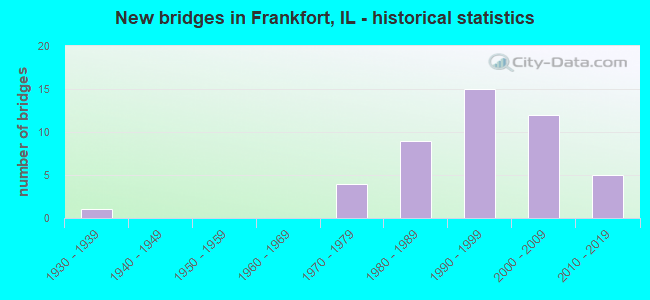
- New bridges - historical statistics
- 11930-1939
- 41970-1979
- 91980-1989
- 151990-1999
- 122000-2009
- 52010-2019
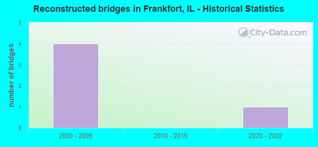
- Reconstructed bridges - Historical Statistics
- 42000-2009
- 02010-2019
- 12020-2022
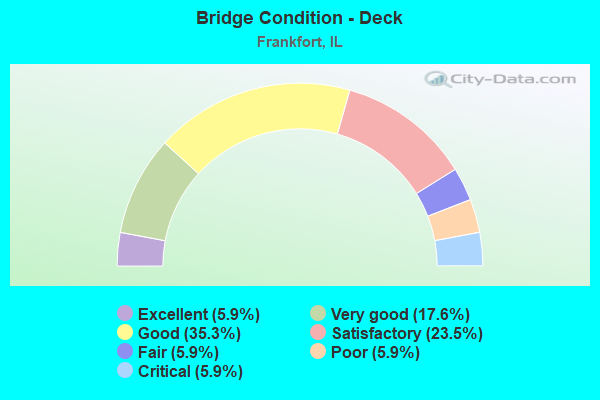
- Bridge Condition - Deck
- 5.9%Excellent
- 17.6%Very good
- 35.3%Good
- 23.5%Satisfactory
- 5.9%Fair
- 5.9%Poor
- 5.9%Critical
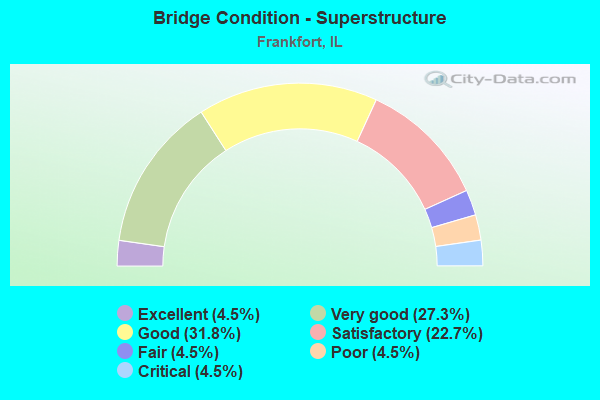
- Bridge Condition - Superstructure
- 4.5%Excellent
- 27.3%Very good
- 31.8%Good
- 22.7%Satisfactory
- 4.5%Fair
- 4.5%Poor
- 4.5%Critical
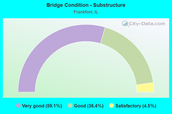
- Bridge Condition - Substructure
- 59.1%Very good
- 36.4%Good
- 4.5%Satisfactory
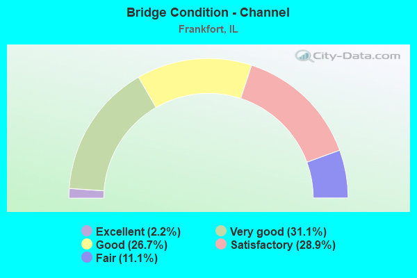
- Bridge Condition - Channel
- 2.2%Excellent
- 31.1%Very good
- 26.7%Good
- 28.9%Satisfactory
- 11.1%Fair
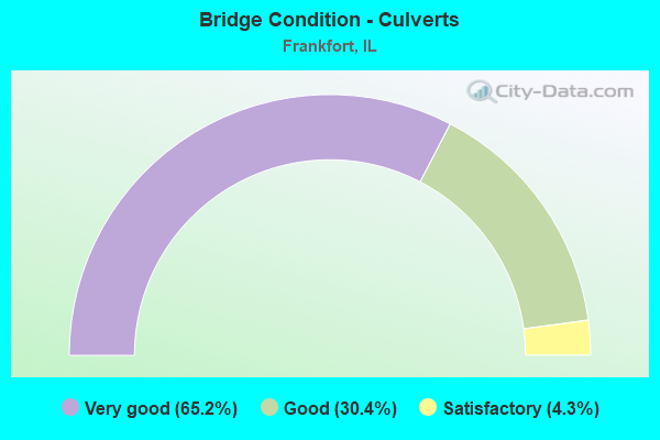
- Bridge Condition - Culverts
- 65.2%Very good
- 30.4%Good
- 4.3%Satisfactory
Find on map >> Show street view
Structure Number: 996022, Location: 0.2MI S OF LARAWAY (Lat: 41.480497, Lng: -87.809636), Route carried "on" structure: Other road , Year Built: 2000, Status: Open, Structure Length: 0.88m (2.89ft), Average Daily Traffic: 1,600 (year 2019), Truck Traffic: 7%, Average Future Daily Traffic: 503 (year 2032), Features Intersected: HICKORY CREEK TRIB, Facility Carried by Structure: 80TH AVENUE
Minimum Vertical Clearance: 30+ m (98+ ft), Kilometerpoint: 0.805, Lanes on structure: 2, Owner: City or Municipal Highway Agency, Approaching Roadway Width: 11.0m (36.1ft), Material/Design: Concrete, Design/Construction: Frame, Number Of Spans In Main Unit: 1, Length of Maximum Span: 8.8m (28.9ft), Curb or Sidewalk Widths: Left: 2.7m (8.9ft), Right: 0.0m, Curb-To-Curb Width: 11.0m (36.1ft), Out-to-Out Width: 11.9m (39.0ft)
Condition: Superstructure: Very good, Substructure: Very good, Channel: Very good, Operating Rating: 53.8 metric tons, Method Used To Determine Operating Rating: Field evaluation and documented engineering judgment, Inventory Rating: 32.4 metric tons, Method Used To Determine Inventory Rating: Field evaluation and documented engineering judgment, Structural Evaluation: Equal to present desirable criteria, Deck Geometry: Equal to present minimum criteria, Waterway Adequacy: Equal to present desirable criteria, Approach Roadway Alignment: Equal to present desirable criteria, Designated Inspection Frequency: Every 48 months, Inspection Date: May 2018, Wearing Surface/Protective System: Wearing Surface: Bituminous
Find on map >> Show street view
Structure Number: 996029, Location: 0.6 Mi. W. of US 45 (Lat: 41.469814, Lng: -87.895094), Route carried "on" structure: City street , Year Built: 2017, Status: Open, Structure Length: 2.82m (9.25ft), Average Daily Traffic: 3,800 (year 2019), Truck Traffic: 6%, Average Future Daily Traffic: 5,845 (year 2040), Design Load: HS 25 or greater, Features Intersected: Jackson Creek, Facility Carried by Structure: Steger Road
Minimum Vertical Clearance: 30+ m (98+ ft), Kilometerpoint: 0.949, Lanes on structure: 2, Owner: City or Municipal Highway Agency, Approaching Roadway Width: 11.0m (36.1ft), Skew: 4 degrees, Material/Design: Concrete, Design/Construction: Culvert, Number Of Spans In Main Unit: 5, Length of Maximum Span: 27.4m (89.9ft), Curb-To-Curb Width: 11.0m (36.1ft)
Condition: Channel: Very good, Culverts: Very good, Operating Rating: 65.1 metric tons, Method Used To Determine Operating Rating: Load and Resistance Factor Rating (LRFR) rating reported by rating factor(RF) method using HL-93 loadings, Inventory Rating: 50.2 metric tons, Method Used To Determine Inventory Rating: Load and Resistance Factor Rating (LRFR) rating reported by rating factor(RF) method using HL-93 loadings, Structural Evaluation: Equal to present desirable criteria, Deck Geometry: Somewhat better than minimum adequacy, Waterway Adequacy: Equal to present desirable criteria, Approach Roadway Alignment: Equal to present desirable criteria, Designated Inspection Frequency: Every 48 months, Inspection Date: June 2021
Find on map >> Show street view
Structure Number: 99635, Location: FRANKFORT (Lat: 41.513942, Lng: -87.832122), Route carried "on" structure: City street , Year Built: 2005, Status: Open, Structure Length: 3.72m (12.20ft), Average Daily Traffic: 1,200 (year 2019), Truck Traffic: 9%, Average Future Daily Traffic: 683 (year 2032), Design Load: HS 20, Features Intersected: HICKORY CR., Facility Carried by Structure: PFEIFFER RD
Minimum Vertical Clearance: 30+ m (98+ ft), Kilometerpoint: 0.966, Lanes on structure: 2, Owner: City or Municipal Highway Agency, Approaching Roadway Width: 9.4m (30.8ft), Skew: 3 degrees, Material/Design: Prestressed concrete, Design/Construction: Stringer/Multi-beam, Number Of Spans In Main Unit: 2, Length of Maximum Span: 18.4m (60.4ft), Curb or Sidewalk Widths: Left: 2.5m (8.2ft), Right: 1.5m (4.9ft), Curb-To-Curb Width: 9.4m (30.8ft), Out-to-Out Width: 14.6m (47.9ft)
Condition: Deck: Very good, Superstructure: Very good, Substructure: Very good, Channel: Very good, Operating Rating: 53.8 metric tons, Method Used To Determine Operating Rating: Assigned rating based on Load Factor Design (LFD) reported by rating factor (RF) using MS18 loading, Inventory Rating: 32.4 metric tons, Method Used To Determine Inventory Rating: Assigned rating based on Load Factor Design (LFD) reported by rating factor (RF) using MS18 loading, Structural Evaluation: Equal to present desirable criteria, Deck Geometry: Somewhat better than minimum adequacy, Waterway Adequacy: Equal to present desirable criteria, Approach Roadway Alignment: Equal to present desirable criteria, Designated Inspection Frequency: Every 48 months, Inspection Date: September 2021, Deck Structure Type: Concrete Cast-file-Place
Find on map >> Show street view
Structure Number: 999909, Location: 0.5 MI N. OF US 30 (Lat: 41.512042, Lng: -87.873889), Route carried "on" structure: County highway , Year Built: 2015, Status: Open, Structure Length: 1.01m (3.31ft), Average Daily Traffic: 375 (year 2019), Truck Traffic: 12%, Average Future Daily Traffic: 670 (year 2032), Design Load: HS 25 or greater, Features Intersected: HICKORY CREEK TRIB, Facility Carried by Structure: IRONWOOD DR
Minimum Vertical Clearance: 30+ m (98+ ft), Kilometerpoint: 0.531, Lanes on structure: 2, Owner: Town or Township Highway Agency, Approaching Roadway Width: 6.7m (22.0ft), Skew: 1 degrees, Material/Design: Concrete, Design/Construction: Culvert, Number Of Spans In Main Unit: 3, Length of Maximum Span: 3.7m (12.1ft)
Condition: Channel: Good, Culverts: Very good, Operating Rating: 42.1 metric tons, Method Used To Determine Operating Rating: Assigned ratings based on Load and Resistance Factor Design (LRFD) reported by rating factor (RF) using HL93 loadings, Inventory Rating: 32.4 metric tons, Method Used To Determine Inventory Rating: Assigned ratings based on Load and Resistance Factor Design (LRFD) reported by rating factor (RF) using HL93 loadings, Structural Evaluation: Equal to present desirable criteria, Waterway Adequacy: Superior to present desirable criteria, Approach Roadway Alignment: Equal to present desirable criteria, Designated Inspection Frequency: Every 48 months, Inspection Date: June 2021
Find on map >> Show street view
Structure Number: 990223, Location: 1.3M S OF US 30 (Lat: 41.491878, Lng: -87.868053), Route carried "under" structure: US 45, Year Built: 1933, Structure Length: 0. m, Average Daily Traffic: 12,500 (year 2021), Truck Traffic: 8%, Features Intersected: US 45, Facility Carried by Structure: EJ & E RR
Minimum Vertical Clearance: 4.32m (14.17ft), Kilometerpoint: 566.120, Lanes under structure: 2, Material/Design: Steel, Design/Construction: Girder and Floorbeam System, Length of Maximum Span: 20.1m (65.9ft)
Find on map >> Show street view
Structure Number: 994628, Location: 0.8 M SW US-30 (Lat: 41.499011, Lng: -87.860650), Route carried "under" structure: US 45, Structure Length: 0. m, Average Daily Traffic: 22,600 (year 2021), Truck Traffic: 4%, Features Intersected: US-45, Facility Carried by Structure: OLD PLANK TRAIL
Minimum Vertical Clearance: 5.84m (19.16ft), Kilometerpoint: 567.117, Lanes under structure: 4, Material/Design: Steel continuous, Design/Construction: Stayed Girder, Length of Maximum Span: 54.9m (180.1ft)