Bridge Statistics for Eugene, Oregon (OR)
Condition, Traffic, Stress, Structural Evaluation, Project Costs
- National Bridge Inventory (NBI) Statistics
- 226Number of bridges
- 3,402ft / 1,037mTotal length
- $104,434,000Total costs
- 4,116,230Total average daily traffic
- 437,320Total average daily truck traffic
- National Bridge Inventory (NBI) Registered Bridges for Eugene
- No street view available for this location
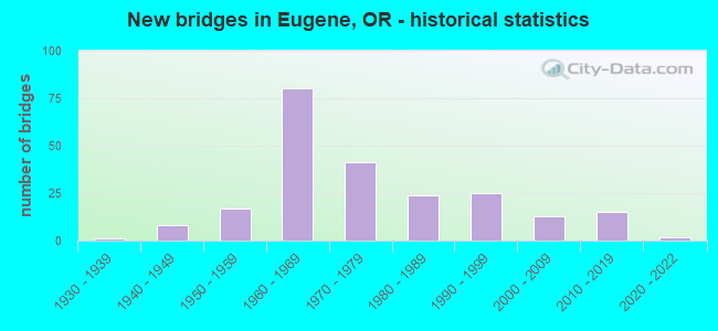
- New bridges - historical statistics
- 11930-1939
- 81940-1949
- 171950-1959
- 801960-1969
- 411970-1979
- 241980-1989
- 251990-1999
- 132000-2009
- 152010-2019
- 22020-2022
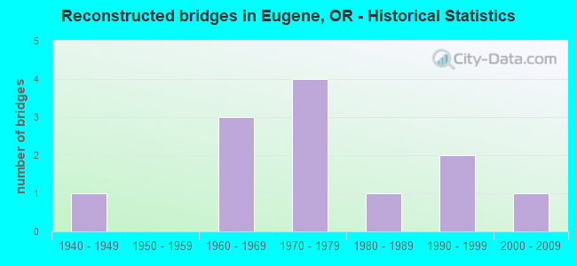
- Reconstructed bridges - Historical Statistics
- 11940-1949
- 01950-1959
- 31960-1969
- 41970-1979
- 11980-1989
- 21990-1999
- 12000-2009
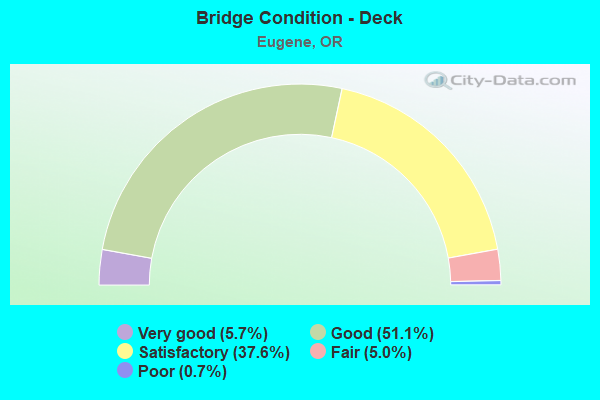
- Bridge Condition - Deck
- 5.7%Very good
- 51.1%Good
- 37.6%Satisfactory
- 5.0%Fair
- 0.7%Poor
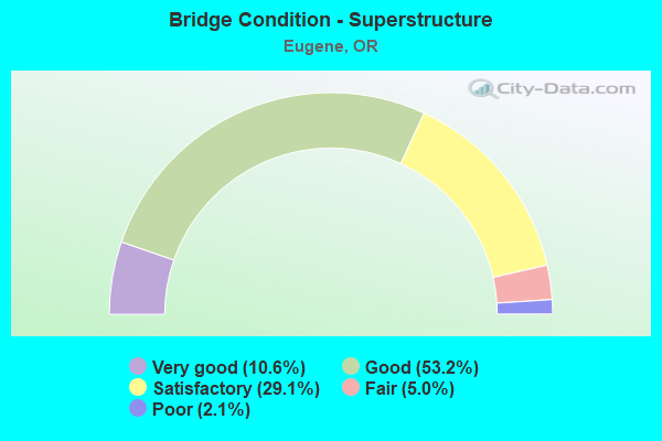
- Bridge Condition - Superstructure
- 10.6%Very good
- 53.2%Good
- 29.1%Satisfactory
- 5.0%Fair
- 2.1%Poor
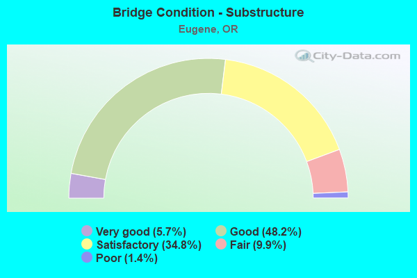
- Bridge Condition - Substructure
- 5.7%Very good
- 48.2%Good
- 34.8%Satisfactory
- 9.9%Fair
- 1.4%Poor
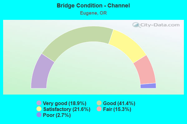
- Bridge Condition - Channel
- 18.9%Very good
- 41.4%Good
- 21.6%Satisfactory
- 15.3%Fair
- 2.7%Poor
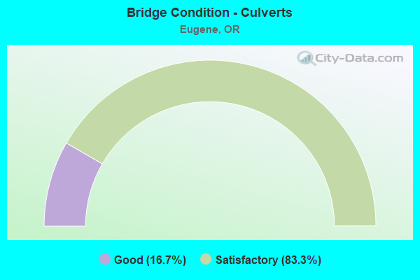
- Bridge Condition - Culverts
- 16.7%Good
- 83.3%Satisfactory
Find on map >> Show street view
Structure Number: 18684 413200192, Location: 065 MI SW EUGENE (Lat: 43.986631, Lng: -123.214669), Route carried "on" structure: County highway C4132, Year Built: 1998, Status: Open, Structure Length: 2.23m (7.32ft), Average Daily Traffic: 1,592 (year 2020), Truck Traffic: 10%, Average Future Daily Traffic: 1,867 (year 2025), Design Load: HS 25 or greater, Features Intersected: SPENCER CREEK, Facility Carried by Structure: SPENCER CR RD
Minimum Vertical Clearance: 30+ m (98+ ft), Kilometerpoint: 3.072, Lanes on structure: 2, Owner: County Highway Agency, Approaching Roadway Width: 9.1m (29.9ft), Skew: 2 degrees, Material/Design: Prestressed concrete, Design/Construction: Slab, Number Of Spans In Main Unit: 2, Length of Maximum Span: 11.0m (36.1ft), Curb-To-Curb Width: 10.1m (33.1ft), Out-to-Out Width: 11.1m (36.4ft)
Condition: Deck: Good, Superstructure: Good, Substructure: Fair, Channel: Fair, Operating Rating: 38.1 metric tons, Method Used To Determine Operating Rating: Load Factor (LF), Inventory Rating: 22.7 metric tons, Method Used To Determine Inventory Rating: Load Factor (LF), Structural Evaluation: Somewhat better than minimum adequacy, Deck Geometry: Somewhat better than minimum adequacy, Waterway Adequacy: Equal to present desirable criteria, Approach Roadway Alignment: Equal to present desirable criteria, Designated Inspection Frequency: Every 24 months, Inspection Date: July 2020, Deck Structure Type: Other, Wearing Surface/Protective System: Wearing Surface: Bituminous
Find on map >> Show street view
Structure Number: 18746 00000 003, Location: 5.0 MI. EAST OF LEABURG (Lat: 44.129439, Lng: -122.615150), Route carried "on" structure: Other road , Year Built: 1952, Status: Open, Structure Length: 2.35m (7.71ft), Average Daily Traffic: 52 (year 2020), Average Future Daily Traffic: 60 (year 2025), Design Load: HS 20, Features Intersected: EWEB POWER CANAL, Facility Carried by Structure: MOUNTAIN VIEW ROAD
Minimum Vertical Clearance: 30.18m (99.02ft), Kilometerpoint: 0.483, Lanes on structure: 1, Owner: Local Agency, Approaching Roadway Width: 3.7m (12.1ft), Material/Design: Concrete, Design/Construction: Tee Beam, Number Of Spans In Main Unit: 3, Length of Maximum Span: 7.6m (24.9ft), Curb-To-Curb Width: 3.6m (11.8ft), Out-to-Out Width: 3.9m (12.8ft)
Condition: Deck: Fair, Superstructure: Poor, Substructure: Fair, Channel: Good, Operating Rating: 27.2 metric tons, Method Used To Determine Operating Rating: Load and Resistance Factor Rating (LRFR) rating reported by rating factor(RF) method using HL-93 loadings, Inventory Rating: 21.1 metric tons, Method Used To Determine Inventory Rating: Load and Resistance Factor Rating (LRFR) rating reported by rating factor(RF) method using HL-93 loadings, Structural Evaluation: Meets minimum limits, Deck Geometry: High priority of corrective action, Waterway Adequacy: Equal to present desirable criteria, Approach Roadway Alignment: Equal to present minimum criteria, Length Of Structure Improvement: 3.00m (9.84ft), Designated Inspection Frequency: Every 24 months, Underwater Inspection Frequency: Every 60 months, Inspection Date: August 2020, Underwater Inspection Date: April 2018, Bridge Improvement Cost: $320,000, Roadway Improvement Cost: $32,000, Total Project Cost: $513,000, Deck Structure Type: Concrete Cast-file-Place, Wearing Surface/Protective System: Wearing Surface: Monolithic Concrete
Find on map >> Show street view
Structure Number: 18748 00000 001, Location: 1.5 Mi. E of Walterville. (Lat: 44.126539, Lng: -122.623267), Route carried "on" structure: Other road , Year Built: 1967, Status: Open, Structure Length: 2.65m (8.69ft), Average Daily Traffic: 77 (year 2020), Truck Traffic: 1%, Average Future Daily Traffic: 88 (year 2025), Design Load: HS 20, Features Intersected: EWEB POWER CANAL, Facility Carried by Structure: PUBLIC ROAD
Minimum Vertical Clearance: 30.18m (99.02ft), Kilometerpoint: 0.161, Lanes on structure: 1, Owner: Local Agency, Approaching Roadway Width: 4.3m (14.1ft), Material/Design: Prestressed concrete, Design/Construction: Slab, Number Of Spans In Main Unit: 3, Length of Maximum Span: 8.5m (27.9ft), Curb-To-Curb Width: 4.4m (14.4ft), Out-to-Out Width: 4.9m (16.1ft)
Condition: Deck: Satisfactory, Superstructure: Satisfactory, Substructure: Good, Channel: Very good, Operating Rating: 30.1 metric tons, Method Used To Determine Operating Rating: Load and Resistance Factor Rating (LRFR) rating reported by rating factor(RF) method using HL-93 loadings, Inventory Rating: 23.3 metric tons, Method Used To Determine Inventory Rating: Load and Resistance Factor Rating (LRFR) rating reported by rating factor(RF) method using HL-93 loadings, Structural Evaluation: Equal to present minimum criteria, Deck Geometry: Equal to present minimum criteria, Waterway Adequacy: Equal to present desirable criteria, Approach Roadway Alignment: Equal to present desirable criteria, Designated Inspection Frequency: Every 24 months, Underwater Inspection Frequency: Every 60 months, Inspection Date: August 2020, Underwater Inspection Date: June 2018, Deck Structure Type: Other, Wearing Surface/Protective System: Wearing Surface: Bituminous
Find on map >> Show street view
Structure Number: 18754 00000 001, Location: IN LANE CNTY FAIRGROUNDS (Lat: 44.043519, Lng: -123.103219), Route carried "on" structure: Other road , Year Built: 1970, Status: Open, Structure Length: 1.86m (6.10ft), Average Daily Traffic: 59 (year 2020), Truck Traffic: 1%, Average Future Daily Traffic: 68 (year 2025), Design Load: HS 20, Features Intersected: AMAZON CREEK, Facility Carried by Structure: FAIRGROUNDS ROAD
Minimum Vertical Clearance: 30.18m (99.02ft), Kilometerpoint: 0.016, Lanes on structure: 2, Owner: Local Agency, Approaching Roadway Width: 6.1m (20.0ft), Material/Design: Prestressed concrete, Design/Construction: Slab, Number Of Spans In Main Unit: 1, Length of Maximum Span: 18.0m (59.1ft), Curb-To-Curb Width: 6.0m (19.7ft), Out-to-Out Width: 6.2m (20.3ft)
Condition: Deck: Satisfactory, Superstructure: Satisfactory, Substructure: Satisfactory, Channel: Satisfactory, Operating Rating: 68.0 metric tons, Method Used To Determine Operating Rating: Load Factor (LF), Inventory Rating: 40.8 metric tons, Method Used To Determine Inventory Rating: Load Factor (LF), Structural Evaluation: Equal to present minimum criteria, Deck Geometry: Meets minimum limits, Waterway Adequacy: Equal to present desirable criteria, Approach Roadway Alignment: Better than present minimum criteria, Designated Inspection Frequency: Every 24 months, Inspection Date: May 2021, Deck Structure Type: Concrete Precast Panels, Wearing Surface/Protective System: Wearing Surface: Monolithic Concrete
Find on map >> Show street view
Structure Number: 18813, Location: WEST EUGENE - N OF W11TH (Lat: 44.051461, Lng: -123.190111), Route carried "on" structure: City street , Year Built: 1998, Status: Open, Structure Length: 0.64m (2.10ft), Average Daily Traffic: 748 (year 2020), Truck Traffic: 2%, Average Future Daily Traffic: 855 (year 2025), Design Load: HS 25 or greater, Features Intersected: POND, Facility Carried by Structure: ED CONE BLVD
Minimum Vertical Clearance: 30.18m (99.02ft), Kilometerpoint: 0.048, Lanes on structure: 2, Owner: City or Municipal Highway Agency, Approaching Roadway Width: 11.6m (38.1ft), Skew: 20 degrees, Material/Design: Steel, Design/Construction: Culvert, Number Of Spans In Main Unit: 1, Length of Maximum Span: 6.4m (21.0ft), Curb or Sidewalk Widths: Left: 1.5m (4.9ft), Right: 1.5m (4.9ft), Curb-To-Curb Width: 11.5m (37.7ft), Out-to-Out Width: 23.0m (75.5ft)
Condition: Channel: Very good, Culverts: Good, Operating Rating: 89.7 metric tons, Method Used To Determine Operating Rating: Load and Resistance Factor Rating (LRFR) rating reported by rating factor(RF) method using HL-93 loadings, Inventory Rating: 69.0 metric tons, Method Used To Determine Inventory Rating: Load and Resistance Factor Rating (LRFR) rating reported by rating factor(RF) method using HL-93 loadings, Structural Evaluation: Better than present minimum criteria, Waterway Adequacy: Equal to present desirable criteria, Approach Roadway Alignment: Equal to present desirable criteria, Designated Inspection Frequency: Every 24 months, Underwater Inspection Frequency: Every 60 months, Inspection Date: May 2021, Underwater Inspection Date: May 2019
Find on map >> Show street view
Structure Number: 18921 123200075, Location: WEST EUGENE (Lat: 44.038411, Lng: -123.171250), Route carried "on" structure: City street C1232, Year Built: 1999, Status: Open, Structure Length: 0.66m (2.17ft), Average Daily Traffic: 4,906 (year 2020), Truck Traffic: 10%, Average Future Daily Traffic: 5,604 (year 2025), Design Load: HS 20, Features Intersected: WILLOW CREEK, Facility Carried by Structure: W 18TH AVE
Minimum Vertical Clearance: 30+ m (98+ ft), Kilometerpoint: 1.207, Lanes on structure: 2, Owner: City or Municipal Highway Agency, Approaching Roadway Width: 10.4m (34.1ft), Material/Design: Concrete continuous, Design/Construction: Culvert, Number Of Spans In Main Unit: 2, Length of Maximum Span: 3.0m (9.8ft), Curb or Sidewalk Widths: Left: 2.6m (8.5ft), Right: 0.0m
Condition: Channel: Good, Culverts: Satisfactory, Operating Rating: 22.9 metric tons, Method Used To Determine Operating Rating: Field evaluation and documented engineering judgment, Inventory Rating: 17.7 metric tons, Method Used To Determine Inventory Rating: Field evaluation and documented engineering judgment, Structural Evaluation: Meets minimum limits, Waterway Adequacy: Equal to present desirable criteria, Approach Roadway Alignment: Equal to present desirable criteria, Designated Inspection Frequency: Every 24 months, Inspection Date: July 2020
Find on map >> Show street view
Structure Number: 18973, Location: SW OF HWY 1 / HWY 227 CON (Lat: 44.059781, Lng: -123.051981), Route carried "on" structure: City street , Year Built: 1959, Status: Posted for load, Structure Length: 0.98m (3.22ft), Average Daily Traffic: 2,995 (year 2020), Truck Traffic: 5%, Average Future Daily Traffic: 3,421 (year 2025), Design Load: HS 20, Features Intersected: Q STREET CANAL, Facility Carried by Structure: GARDEN WAY
Minimum Vertical Clearance: 30+ m (98+ ft), Kilometerpoint: 0.000, Lanes on structure: 2, Owner: City or Municipal Highway Agency, Approaching Roadway Width: 7.3m (24.0ft), Material/Design: Concrete continuous, Design/Construction: Culvert, Number Of Spans In Main Unit: 3, Length of Maximum Span: 3.0m (9.8ft)
Condition: Channel: Satisfactory, Culverts: Satisfactory, Operating Rating: 25.5 metric tons, Method Used To Determine Operating Rating: Field evaluation and documented engineering judgment, Inventory Rating: 19.7 metric tons, Method Used To Determine Inventory Rating: Field evaluation and documented engineering judgment, Structural Evaluation: Somewhat better than minimum adequacy, Waterway Adequacy: Better than present minimum criteria, Approach Roadway Alignment: Equal to present desirable criteria, Bridge Posting: Required (Relationship of Operating Rating to Maximum Legal Load: 10.0 - 19.9% below), Length Of Structure Improvement: 1.00m (3.28ft), Designated Inspection Frequency: Every 24 months, Inspection Date: May 2021, Bridge Improvement Cost: $102,000, Roadway Improvement Cost: $10,000, Total Project Cost: $164,000
Find on map >> Show street view
Structure Number: 19057, Location: EUGENE: N DANEBO AVE (Lat: 44.064469, Lng: -123.178189), Route carried "on" structure: City street , Year Built: 1969, Status: Open, Structure Length: 0.64m (2.10ft), Average Daily Traffic: 5,990 (year 2020), Truck Traffic: 7%, Average Future Daily Traffic: 6,842 (year 2025), Design Load: HS 20, Features Intersected: A3 CHANNEL, Facility Carried by Structure: N DANEBO AVE
Minimum Vertical Clearance: 30+ m (98+ ft), Kilometerpoint: 0.000, Lanes on structure: 3, Owner: City or Municipal Highway Agency, Approaching Roadway Width: 11.0m (36.1ft), Skew: 10 degrees, Material/Design: Concrete continuous, Design/Construction: Culvert, Number Of Spans In Main Unit: 2, Length of Maximum Span: 3.0m (9.8ft), Curb-To-Curb Width: 10.8m (35.4ft), Out-to-Out Width: 10.8m (35.4ft)
Condition: Channel: Satisfactory, Culverts: Satisfactory, Operating Rating: 24.5 metric tons, Method Used To Determine Operating Rating: Field evaluation and documented engineering judgment, Inventory Rating: 19.0 metric tons, Method Used To Determine Inventory Rating: Field evaluation and documented engineering judgment, Structural Evaluation: Meets minimum limits, Deck Geometry: High priority of replacement, Waterway Adequacy: Equal to present desirable criteria, Approach Roadway Alignment: Equal to present desirable criteria, Length Of Structure Improvement: 0.60m (1.97ft), Designated Inspection Frequency: Every 24 months, Inspection Date: May 2021, Bridge Improvement Cost: $67,000, Roadway Improvement Cost: $7,000, Total Project Cost: $108,000, Deck Structure Type: Concrete Cast-file-Place
Find on map >> Show street view
Structure Number: 19058, Location: EUGENE: N TERRY ST (Lat: 44.063322, Lng: -123.188267), Route carried "on" structure: City street , Year Built: 1960, Status: Open, Structure Length: 0.64m (2.10ft), Average Daily Traffic: 1,198 (year 2020), Truck Traffic: 2%, Average Future Daily Traffic: 1,369 (year 2025), Design Load: HS 20, Features Intersected: A3 CHANNEL, Facility Carried by Structure: NO. TERRY STREET
Minimum Vertical Clearance: 30+ m (98+ ft), Kilometerpoint: 0.000, Lanes on structure: 2, Owner: City or Municipal Highway Agency, Approaching Roadway Width: 9.1m (29.9ft), Skew: 21 degrees, Material/Design: Concrete continuous, Design/Construction: Culvert, Number Of Spans In Main Unit: 2, Length of Maximum Span: 3.2m (10.5ft), Curb or Sidewalk Widths: Left: 1.5m (4.9ft), Right: 1.5m (4.9ft), Curb-To-Curb Width: 5.2m (17.1ft), Out-to-Out Width: 13.1m (43.0ft)
Condition: Channel: Good, Culverts: Satisfactory, Operating Rating: 25.1 metric tons, Method Used To Determine Operating Rating: Field evaluation and documented engineering judgment, Inventory Rating: 19.3 metric tons, Method Used To Determine Inventory Rating: Field evaluation and documented engineering judgment, Structural Evaluation: Somewhat better than minimum adequacy, Deck Geometry: High priority of replacement, Waterway Adequacy: Equal to present desirable criteria, Approach Roadway Alignment: Equal to present desirable criteria, Length Of Structure Improvement: 0.60m (1.97ft), Designated Inspection Frequency: Every 24 months, Inspection Date: May 2021, Bridge Improvement Cost: $67,000, Roadway Improvement Cost: $7,000, Total Project Cost: $108,000, Deck Structure Type: Concrete Cast-file-Place, Wearing Surface/Protective System: Wearing Surface: Bituminous
Find on map >> Show street view
Structure Number: 19136, Location: SPRINGWOOD DR N OF EUGENE (Lat: 44.130389, Lng: -123.141300), Route carried "on" structure: City street , Year Built: 2001, Status: Open, Structure Length: 0.82m (2.69ft), Average Daily Traffic: 150 (year 2020), Truck Traffic: 2%, Average Future Daily Traffic: 172 (year 2025), Design Load: HS 20, Features Intersected: SPRING CREEK, Facility Carried by Structure: PUBLIC ROAD
Minimum Vertical Clearance: 30+ m (98+ ft), Kilometerpoint: 0.209, Lanes on structure: 2, Owner: City or Municipal Highway Agency, Approaching Roadway Width: 6.4m (21.0ft), Material/Design: Concrete continuous, Design/Construction: Culvert, Number Of Spans In Main Unit: 2, Length of Maximum Span: 3.7m (12.1ft), Curb or Sidewalk Widths: Left: 2.0m (6.6ft), Right: 2.0m (6.6ft)
Condition: Channel: Fair, Culverts: Good, Operating Rating: 38.2 metric tons, Method Used To Determine Operating Rating: Load and Resistance Factor Rating (LRFR) rating reported by rating factor(RF) method using HL-93 loadings, Inventory Rating: 29.5 metric tons, Method Used To Determine Inventory Rating: Load and Resistance Factor Rating (LRFR) rating reported by rating factor(RF) method using HL-93 loadings, Structural Evaluation: Better than present minimum criteria, Waterway Adequacy: Equal to present desirable criteria, Approach Roadway Alignment: Equal to present desirable criteria, Designated Inspection Frequency: Every 24 months, Inspection Date: July 2020, Wearing Surface/Protective System: Wearing Surface: Bituminous
Find on map >> Show street view
Structure Number: 20060 001 19546, Location: NCL Eugene (Lat: 44.083600, Lng: -123.047200), Route carried "on" structure: Ramp Interstate 5, Year Built: 2008, Status: Open, Structure Length: 63.00m (206.69ft), Average Daily Traffic: 15,131 (year 2020), Truck Traffic: 17%, Average Future Daily Traffic: 14,300 (year 2030), Design Load: HL 93, Features Intersected: I-5 (HWY 001), Facility Carried by Structure: HWY 1NB CONN
Minimum Vertical Clearance: 30+ m (98+ ft), Kilometerpoint: 314.562, Lanes on structure: 2, Lanes under structure: 13, Base Highway Network: Yes, Owner: State Highway Agency, Approaching Roadway Width: 12.8m (42.0ft), Material/Design: Prestressed concrete continuous, Design/Construction: Box Beam or Girders - Multiple, Number Of Spans In Main Unit: 10, Length of Maximum Span: 85.0m (278.9ft), Curb-To-Curb Width: 12.8m (42.0ft), Out-to-Out Width: 13.8m (45.3ft)
Condition: Deck: Satisfactory, Superstructure: Good, Substructure: Satisfactory, Operating Rating: 46.0 metric tons, Method Used To Determine Operating Rating: Load and Resistance Factor Rating (LRFR) rating reported by rating factor(RF) method using HL-93 loadings, Inventory Rating: 35.6 metric tons, Method Used To Determine Inventory Rating: Load and Resistance Factor Rating (LRFR) rating reported by rating factor(RF) method using HL-93 loadings, Structural Evaluation: Equal to present minimum criteria, Deck Geometry: Superior to present desirable criteria, Underclear: High priority of corrective action, Approach Roadway Alignment: Equal to present desirable criteria, Designated Inspection Frequency: Every 24 months, Inspection Date: March 2021, Deck Structure Type: Concrete Cast-file-Place, Wearing Surface/Protective System: Wearing Surface: Monolithic Concrete
Find on map >> Show street view
Structure Number: 20407 000 00005, Location: EUGENE - U of O CAMPUS. (Lat: 44.047519, Lng: -123.071469), Route carried "on" structure: Other road , Year Built: 2007, Status: Open, Structure Length: 1.97m (6.46ft), Average Daily Traffic: 208 (year 2010), Truck Traffic: 2%, Average Future Daily Traffic: 297 (year 2030), Features Intersected: MILL RACE CANAL, Facility Carried by Structure: U OF OREGON ACCESS
Minimum Vertical Clearance: 30.18m (99.02ft), Kilometerpoint: 0.080, Lanes on structure: 2, Owner: State Agenciy, Approaching Roadway Width: 7.3m (24.0ft), Material/Design: Prestressed concrete, Design/Construction: Slab, Number Of Spans In Main Unit: 1, Length of Maximum Span: 19.7m (64.6ft), Curb or Sidewalk Widths: Left: 1.4m (4.6ft), Right: 2.4m (7.9ft), Curb-To-Curb Width: 7.3m (24.0ft), Out-to-Out Width: 11.7m (38.4ft)
Condition: Deck: Very good, Superstructure: Good, Substructure: Very good, Channel: Good, Operating Rating: 85.5 metric tons, Method Used To Determine Operating Rating: Load and Resistance Factor Rating (LRFR) rating reported by rating factor(RF) method using HL-93 loadings, Inventory Rating: 66.1 metric tons, Method Used To Determine Inventory Rating: Load and Resistance Factor Rating (LRFR) rating reported by rating factor(RF) method using HL-93 loadings, Structural Evaluation: Better than present minimum criteria, Deck Geometry: Somewhat better than minimum adequacy, Waterway Adequacy: Equal to present desirable criteria, Approach Roadway Alignment: Equal to present desirable criteria, Designated Inspection Frequency: Every 24 months, Inspection Date: June 2020, Deck Structure Type: Concrete Precast Panels, Wearing Surface/Protective System: Wearing Surface: Bituminous
Find on map >> Show street view
Structure Number: 20597 001 1974, Location: 044 MI N OF EUGENE NCL (Lat: 44.111961, Lng: -123.045200), Route carried "on" structure: Interstate 5, Year Built: 2008, Status: Open, Structure Length: 24.08m (79.00ft), Average Daily Traffic: 18,109 (year 2020), Truck Traffic: 26%, Average Future Daily Traffic: 23,150 (year 2040), Design Load: HL 93, Features Intersected: MCKENZIE R & FRONT RD
Minimum Vertical Clearance: 30+ m (98+ ft), Kilometerpoint: 317.685, Lanes on structure: 2, Lanes under structure: 4, Base Highway Network: Yes, Owner: State Highway Agency, Approaching Roadway Width: 12.8m (42.0ft), Skew: 3 degrees, Material/Design: Prestressed concrete continuous, Design/Construction: Stringer/Multi-beam, Number Of Spans In Main Unit: 6, Length of Maximum Span: 54.9m (180.1ft), Curb-To-Curb Width: 12.8m (42.0ft), Out-to-Out Width: 19.1m (62.7ft)
Condition: Deck: Satisfactory, Superstructure: Good, Substructure: Good, Channel: Very good, Operating Rating: 42.8 metric tons, Method Used To Determine Operating Rating: Load and Resistance Factor Rating (LRFR) rating reported by rating factor(RF) method using HL-93 loadings, Inventory Rating: 33.0 metric tons, Method Used To Determine Inventory Rating: Load and Resistance Factor Rating (LRFR) rating reported by rating factor(RF) method using HL-93 loadings, Structural Evaluation: Better than present minimum criteria, Deck Geometry: Equal to present desirable criteria, Underclear: Meets minimum limits, Waterway Adequacy: Equal to present desirable criteria, Approach Roadway Alignment: Equal to present desirable criteria, Designated Inspection Frequency: Every 24 months, Underwater Inspection Frequency: Every 60 months, Inspection Date: March 2021, Underwater Inspection Date: August 2021, Deck Structure Type: Concrete Cast-file-Place, Wearing Surface/Protective System: Wearing Surface: Monolithic Concrete
Find on map >> Show street view
Structure Number: 20598 001 1974, Location: 044 MI N OF EUGENE NCL (Lat: 44.111983, Lng: -123.045667), Route carried "on" structure: Interstate 5, Year Built: 2008, Status: Open, Structure Length: 24.08m (79.00ft), Average Daily Traffic: 18,109 (year 2020), Truck Traffic: 26%, Average Future Daily Traffic: 23,150 (year 2040), Design Load: HL 93, Features Intersected: MCKENZIE R & FRONT RD
Minimum Vertical Clearance: 30+ m (98+ ft), Kilometerpoint: 317.685, Lanes on structure: 2, Lanes under structure: 4, Base Highway Network: Yes, Owner: State Highway Agency, Approaching Roadway Width: 12.8m (42.0ft), Skew: 3 degrees, Material/Design: Prestressed concrete continuous, Design/Construction: Stringer/Multi-beam, Number Of Spans In Main Unit: 6, Length of Maximum Span: 54.9m (180.1ft), Curb-To-Curb Width: 12.8m (42.0ft), Out-to-Out Width: 19.1m (62.7ft)
Condition: Deck: Satisfactory, Superstructure: Good, Substructure: Satisfactory, Channel: Very good, Operating Rating: 42.8 metric tons, Method Used To Determine Operating Rating: Load and Resistance Factor Rating (LRFR) rating reported by rating factor(RF) method using HL-93 loadings, Inventory Rating: 33.0 metric tons, Method Used To Determine Inventory Rating: Load and Resistance Factor Rating (LRFR) rating reported by rating factor(RF) method using HL-93 loadings, Structural Evaluation: Equal to present minimum criteria, Deck Geometry: Equal to present desirable criteria, Underclear: Meets minimum limits, Waterway Adequacy: Equal to present desirable criteria, Approach Roadway Alignment: Equal to present desirable criteria, Designated Inspection Frequency: Every 24 months, Underwater Inspection Frequency: Every 60 months, Inspection Date: March 2021, Underwater Inspection Date: August 2021, Deck Structure Type: Concrete Cast-file-Place, Wearing Surface/Protective System: Wearing Surface: Monolithic Concrete
Find on map >> Show street view
Structure Number: 21038 001 19275, Location: 01.1 MI N OF EUGENE SCL (Lat: 44.044950, Lng: -123.050131), Route carried "on" structure: Interstate 5, Year Built: 2012, Status: Open, Structure Length: 60.49m (198.46ft), Average Daily Traffic: 25,834 (year 2020), Truck Traffic: 17%, Average Future Daily Traffic: 41,100 (year 2040), Design Load: HL 93, Features Intersected: WILLAMETTE R HWY015 UPRR
Minimum Vertical Clearance: 30+ m (98+ ft), Kilometerpoint: 310.201, Lanes on structure: 2, Lanes under structure: 5, Base Highway Network: Yes, Owner: State Highway Agency, Approaching Roadway Width: 19.5m (64.0ft), Material/Design: Concrete continuous, Design/Construction: Arch - Deck, Number Of Spans In Main Unit: 2, Number Of Approach Spans: 8, Length of Maximum Span: 126.8m (416.0ft), Curb-To-Curb Width: 19.5m (64.0ft), Out-to-Out Width: 20.6m (67.6ft)
Condition: Deck: Satisfactory, Superstructure: Very good, Substructure: Good, Channel: Good, Operating Rating: 40.2 metric tons, Method Used To Determine Operating Rating: Load and Resistance Factor Rating (LRFR) rating reported by rating factor(RF) method using HL-93 loadings, Inventory Rating: 31.1 metric tons, Method Used To Determine Inventory Rating: Load and Resistance Factor Rating (LRFR) rating reported by rating factor(RF) method using HL-93 loadings, Structural Evaluation: Better than present minimum criteria, Deck Geometry: Superior to present desirable criteria, Underclear: High priority of corrective action, Waterway Adequacy: Equal to present desirable criteria, Approach Roadway Alignment: Equal to present desirable criteria, Designated Inspection Frequency: Every 24 months, Underwater Inspection Frequency: Every 60 months, Inspection Date: March 2021, Underwater Inspection Date: August 2018, Deck Structure Type: Concrete Cast-file-Place, Wearing Surface/Protective System: Wearing Surface: Monolithic Concrete
Find on map >> Show street view
Structure Number: 21039 001 19275, Location: 01.1 MI N OF EUGENE SCL (Lat: 44.044950, Lng: -123.050139), Route carried "on" structure: Interstate 5, Year Built: 2011, Status: Open, Structure Length: 53.61m (175.89ft), Average Daily Traffic: 25,834 (year 2020), Truck Traffic: 17%, Average Future Daily Traffic: 41,100 (year 2040), Design Load: HL 93, Features Intersected: WILLAMETTE R HWY 15 UPRR
Minimum Vertical Clearance: 30+ m (98+ ft), Kilometerpoint: 310.201, Lanes on structure: 2, Lanes under structure: 5, Base Highway Network: Yes, Owner: State Highway Agency, Approaching Roadway Width: 19.5m (64.0ft), Material/Design: Concrete continuous, Design/Construction: Arch - Deck, Number Of Spans In Main Unit: 2, Number Of Approach Spans: 7, Length of Maximum Span: 126.8m (416.0ft), Curb-To-Curb Width: 19.5m (64.0ft), Out-to-Out Width: 20.6m (67.6ft)
Condition: Deck: Satisfactory, Superstructure: Good, Substructure: Very good, Channel: Good, Operating Rating: 40.2 metric tons, Method Used To Determine Operating Rating: Load and Resistance Factor Rating (LRFR) rating reported by rating factor(RF) method using HL-93 loadings, Inventory Rating: 31.1 metric tons, Method Used To Determine Inventory Rating: Load and Resistance Factor Rating (LRFR) rating reported by rating factor(RF) method using HL-93 loadings, Structural Evaluation: Better than present minimum criteria, Deck Geometry: Superior to present desirable criteria, Waterway Adequacy: Equal to present desirable criteria, Approach Roadway Alignment: Equal to present desirable criteria, Designated Inspection Frequency: Every 24 months, Underwater Inspection Frequency: Every 60 months, Inspection Date: March 2021, Underwater Inspection Date: August 2018, Deck Structure Type: Concrete Cast-file-Place, Wearing Surface/Protective System: Wearing Surface: Monolithic Concrete
Find on map >> Show street view
Structure Number: 21077 001 19266, Location: 013 MI N of Eugene SCL (Lat: 44.048600, Lng: -123.050000), Route carried "on" structure: Interstate 5, Year Built: 2010, Status: Open, Structure Length: 5.49m (18.01ft), Average Daily Traffic: 51,669 (year 2020), Truck Traffic: 17%, Average Future Daily Traffic: 82,200 (year 2040), Design Load: HL 93, Features Intersected: Patterson Slough, Facility Carried by Structure: Hwy 001
Minimum Vertical Clearance: 30+ m (98+ ft), Kilometerpoint: 310.587, Lanes on structure: 2, Base Highway Network: Yes, Owner: State Highway Agency, Approaching Roadway Width: 19.5m (64.0ft), Material/Design: Prestressed concrete, Design/Construction: Stringer/Multi-beam, Number Of Spans In Main Unit: 1, Length of Maximum Span: 54.9m (180.1ft), Curb-To-Curb Width: 19.5m (64.0ft), Out-to-Out Width: 20.5m (67.3ft)
Condition: Deck: Good, Superstructure: Good, Substructure: Good, Channel: Very good, Operating Rating: 73.5 metric tons, Method Used To Determine Operating Rating: Load and Resistance Factor Rating (LRFR) rating reported by rating factor(RF) method using HL-93 loadings, Inventory Rating: 56.7 metric tons, Method Used To Determine Inventory Rating: Load and Resistance Factor Rating (LRFR) rating reported by rating factor(RF) method using HL-93 loadings, Structural Evaluation: Better than present minimum criteria, Deck Geometry: Superior to present desirable criteria, Waterway Adequacy: Equal to present desirable criteria, Approach Roadway Alignment: Equal to present desirable criteria, Designated Inspection Frequency: Every 24 months, Inspection Date: March 2021, Deck Structure Type: Concrete Cast-file-Place, Wearing Surface/Protective System: Wearing Surface: Monolithic Concrete
Find on map >> Show street view
Structure Number: 21307 069 0006, Location: 02.5 W BELT LINE RD (Lat: 44.055281, Lng: -123.221469), Route carried "on" structure: State highway 569, Year Built: 2010, Status: Open, Structure Length: 6.77m (22.21ft), Average Daily Traffic: 12,930 (year 2020), Truck Traffic: 7%, Average Future Daily Traffic: 18,500 (year 2040), Design Load: HL 93, Features Intersected: COOS BAY RAIL LINK, Facility Carried by Structure: HWY 69
Minimum Vertical Clearance: 30+ m (98+ ft), Kilometerpoint: 0.966, Lanes on structure: 2, Base Highway Network: Yes, Owner: State Highway Agency, Approaching Roadway Width: 12.2m (40.0ft), Skew: 4 degrees, Material/Design: Concrete, Design/Construction: Box Beam or Girders - Multiple, Number Of Spans In Main Unit: 1, Length of Maximum Span: 67.7m (222.1ft), Curb-To-Curb Width: 12.2m (40.0ft), Out-to-Out Width: 13.0m (42.7ft)
Condition: Deck: Good, Superstructure: Good, Substructure: Good, Operating Rating: 57.0 metric tons, Method Used To Determine Operating Rating: Load and Resistance Factor Rating (LRFR) rating reported by rating factor(RF) method using HL-93 loadings, Inventory Rating: 44.1 metric tons, Method Used To Determine Inventory Rating: Load and Resistance Factor Rating (LRFR) rating reported by rating factor(RF) method using HL-93 loadings, Structural Evaluation: Better than present minimum criteria, Deck Geometry: Somewhat better than minimum adequacy, Underclear: Meets minimum limits, Approach Roadway Alignment: Equal to present desirable criteria, Designated Inspection Frequency: Every 24 months, Inspection Date: April 2021, Deck Structure Type: Concrete Cast-file-Place, Wearing Surface/Protective System: Wearing Surface: Monolithic Concrete
Find on map >> Show street view
Structure Number: 21408, Location: NW of Willamette River (Lat: 44.097583, Lng: -123.109678), Route carried "on" structure: City street , Year Built: 2011, Status: Open, Structure Length: 0.79m (2.59ft), Average Daily Traffic: 238 (year 2020), Average Future Daily Traffic: 272 (year 2025), Design Load: HL 93, Features Intersected: West Bank Trail, Facility Carried by Structure: Division Ave
Minimum Vertical Clearance: 30+ m (98+ ft), Kilometerpoint: 0.000, Lanes on structure: 2, Owner: City or Municipal Highway Agency, Approaching Roadway Width: 12.2m (40.0ft), Material/Design: Prestressed concrete, Design/Construction: Slab, Number Of Spans In Main Unit: 1, Length of Maximum Span: 7.9m (25.9ft), Curb-To-Curb Width: 11.4m (37.4ft), Out-to-Out Width: 12.2m (40.0ft)
Condition: Deck: Very good, Superstructure: Very good, Substructure: Good, Operating Rating: 61.9 metric tons, Method Used To Determine Operating Rating: Load and Resistance Factor Rating (LRFR) rating reported by rating factor(RF) method using HL-93 loadings, Inventory Rating: 47.6 metric tons, Method Used To Determine Inventory Rating: Load and Resistance Factor Rating (LRFR) rating reported by rating factor(RF) method using HL-93 loadings, Structural Evaluation: Better than present minimum criteria, Deck Geometry: Superior to present desirable criteria, Approach Roadway Alignment: Equal to present minimum criteria, Designated Inspection Frequency: Every 24 months, Inspection Date: May 2021, Deck Structure Type: Concrete Precast Panels, Wearing Surface/Protective System: Wearing Surface: Bituminous, Membrane: Preformed Fabric
Find on map >> Show street view
Structure Number: 21576 069 01276, Location: JCT HWY 001 - HWY 069 (Lat: 44.084164, Lng: -123.046664), Route carried "on" structure: State highway 569, Year Built: 2014, Status: Open, Structure Length: 7.44m (24.41ft), Average Daily Traffic: 33,069 (year 2020), Truck Traffic: 10%, Average Future Daily Traffic: 48,200 (year 2040), Design Load: HL 93, Features Intersected: I-5 (HWY 001), Facility Carried by Structure: HWY 69
Minimum Vertical Clearance: 30+ m (98+ ft), Kilometerpoint: 20.535, Lanes on structure: 6, Lanes under structure: 7, Base Highway Network: Yes, Owner: State Highway Agency, Approaching Roadway Width: 37.2m (122.0ft), Skew: 30 degrees, Material/Design: Prestressed concrete continuous, Design/Construction: Stringer/Multi-beam, Number Of Spans In Main Unit: 2, Length of Maximum Span: 37.2m (122.0ft), Curb-To-Curb Width: 37.2m (122.0ft), Out-to-Out Width: 38.8m (127.3ft)
Condition: Deck: Satisfactory, Superstructure: Very good, Substructure: Good, Operating Rating: 46.3 metric tons, Method Used To Determine Operating Rating: Load and Resistance Factor Rating (LRFR) rating reported by rating factor(RF) method using HL-93 loadings, Inventory Rating: 35.6 metric tons, Method Used To Determine Inventory Rating: Load and Resistance Factor Rating (LRFR) rating reported by rating factor(RF) method using HL-93 loadings, Structural Evaluation: Better than present minimum criteria, Deck Geometry: Superior to present desirable criteria, Underclear: High priority of corrective action, Approach Roadway Alignment: Equal to present desirable criteria, Designated Inspection Frequency: Every 24 months, Inspection Date: March 2021, Deck Structure Type: Concrete Cast-file-Place, Wearing Surface/Protective System: Wearing Surface: Monolithic Concrete
Find on map >> Show street view
Structure Number: 21655069AW0127, Location: 069 to 001 Interchange (Lat: 44.083031, Lng: -123.048531), Route carried "on" structure: Ramp State highway 569, Year Built: 2014, Status: Open, Structure Length: 1.22m (4.00ft), Average Daily Traffic: 10,542 (year 2020), Truck Traffic: 10%, Average Future Daily Traffic: 51,500 (year 2036), Design Load: HL 93, Features Intersected: Multi-Use, Facility Carried by Structure: HWY 69AW (EB)
Minimum Vertical Clearance: 30+ m (98+ ft), Kilometerpoint: 20.439, Lanes on structure: 1, Base Highway Network: Yes, Owner: State Highway Agency, Approaching Roadway Width: 8.5m (27.9ft), Material/Design: Prestressed concrete, Design/Construction: Slab, Number Of Spans In Main Unit: 1, Length of Maximum Span: 12.2m (40.0ft), Curb-To-Curb Width: 8.5m (27.9ft), Out-to-Out Width: 9.9m (32.5ft)
Condition: Deck: Good, Superstructure: Very good, Substructure: Good, Operating Rating: 48.0 metric tons, Method Used To Determine Operating Rating: Load and Resistance Factor Rating (LRFR) rating reported by rating factor(RF) method using HL-93 loadings, Inventory Rating: 36.9 metric tons, Method Used To Determine Inventory Rating: Load and Resistance Factor Rating (LRFR) rating reported by rating factor(RF) method using HL-93 loadings, Structural Evaluation: Better than present minimum criteria, Deck Geometry: Superior to present desirable criteria, Approach Roadway Alignment: Equal to present desirable criteria, Designated Inspection Frequency: Every 24 months, Inspection Date: March 2021, Deck Structure Type: Concrete Cast-file-Place, Wearing Surface/Protective System: Wearing Surface: Integral Concrete
Find on map >> Show street view
Structure Number: 21656069AZ01292, Location: 069 to 001 Interchange (Lat: 44.085550, Lng: -123.047481), Route carried "on" structure: Ramp State highway 569, Year Built: 2014, Status: Open, Structure Length: 1.22m (4.00ft), Average Daily Traffic: 5,920 (year 2020), Truck Traffic: 10%, Average Future Daily Traffic: 51,500 (year 2036), Design Load: HL 93, Features Intersected: Multi-Use, Facility Carried by Structure: HWY 69AW (EB)
Minimum Vertical Clearance: 30+ m (98+ ft), Kilometerpoint: 20.793, Lanes on structure: 1, Base Highway Network: Yes, Owner: State Highway Agency, Approaching Roadway Width: 8.7m (28.5ft), Material/Design: Prestressed concrete, Design/Construction: Slab, Number Of Spans In Main Unit: 1, Length of Maximum Span: 12.2m (40.0ft), Curb-To-Curb Width: 8.7m (28.5ft), Out-to-Out Width: 9.7m (31.8ft)
Condition: Deck: Good, Superstructure: Very good, Substructure: Good, Operating Rating: 57.7 metric tons, Method Used To Determine Operating Rating: Load and Resistance Factor Rating (LRFR) rating reported by rating factor(RF) method using HL-93 loadings, Inventory Rating: 44.4 metric tons, Method Used To Determine Inventory Rating: Load and Resistance Factor Rating (LRFR) rating reported by rating factor(RF) method using HL-93 loadings, Structural Evaluation: Better than present minimum criteria, Deck Geometry: Superior to present desirable criteria, Approach Roadway Alignment: Equal to present desirable criteria, Designated Inspection Frequency: Every 24 months, Inspection Date: March 2021, Deck Structure Type: Concrete Cast-file-Place, Wearing Surface/Protective System: Wearing Surface: Integral Concrete
Find on map >> Show street view
Structure Number: 21657001LS1959, Location: 001 SB to 069 Interchan (Lat: 44.085511, Lng: -123.047481), Route carried "on" structure: Ramp State highway 569, Year Built: 2014, Status: Open, Structure Length: 1.22m (4.00ft), Average Daily Traffic: 4,396 (year 2020), Truck Traffic: 17%, Average Future Daily Traffic: 45,000 (year 2036), Design Load: HL 93, Features Intersected: Multi-Use, Facility Carried by Structure: Hwy 001 LS Conn
Minimum Vertical Clearance: 30+ m (98+ ft), Kilometerpoint: 315.270, Lanes on structure: 1, Base Highway Network: Yes, Owner: State Highway Agency, Approaching Roadway Width: 8.5m (27.9ft), Material/Design: Prestressed concrete, Design/Construction: Slab, Number Of Spans In Main Unit: 1, Length of Maximum Span: 12.2m (40.0ft), Curb-To-Curb Width: 8.5m (27.9ft), Out-to-Out Width: 11.1m (36.4ft)
Condition: Deck: Good, Superstructure: Very good, Substructure: Good, Operating Rating: 47.3 metric tons, Method Used To Determine Operating Rating: Load and Resistance Factor Rating (LRFR) rating reported by rating factor(RF) method using HL-93 loadings, Inventory Rating: 36.6 metric tons, Method Used To Determine Inventory Rating: Load and Resistance Factor Rating (LRFR) rating reported by rating factor(RF) method using HL-93 loadings, Structural Evaluation: Better than present minimum criteria, Deck Geometry: Superior to present desirable criteria, Approach Roadway Alignment: Equal to present desirable criteria, Designated Inspection Frequency: Every 24 months, Inspection Date: March 2021, Deck Structure Type: Concrete Cast-file-Place, Wearing Surface/Protective System: Wearing Surface: Integral Concrete
Find on map >> Show street view
Structure Number: 22125 069 01276, Location: MP 12.76 (Lat: 44.083850, Lng: -123.046708), Route carried "on" structure: State highway 569, Year Built: 2017, Status: Open, Structure Length: 8.17m (26.80ft), Average Daily Traffic: 16,534 (year 2020), Truck Traffic: 10%, Average Future Daily Traffic: 24,100 (year 2040), Design Load: HL 93, Features Intersected: I-5 (HWY 001), Facility Carried by Structure: HWY 069
Minimum Vertical Clearance: 30+ m (98+ ft), Kilometerpoint: 20.535, Lanes on structure: 1, Lanes under structure: 7, Base Highway Network: Yes, Owner: State Highway Agency, Approaching Roadway Width: 8.5m (27.9ft), Skew: 1 degrees, Material/Design: Prestressed concrete continuous, Design/Construction: Stringer/Multi-beam, Number Of Spans In Main Unit: 2, Length of Maximum Span: 42.4m (139.1ft), Curb-To-Curb Width: 8.5m (27.9ft), Out-to-Out Width: 9.5m (31.2ft)
Condition: Deck: Good, Superstructure: Very good, Substructure: Good, Operating Rating: 68.0 metric tons, Method Used To Determine Operating Rating: Load and Resistance Factor Rating (LRFR) rating reported by rating factor(RF) method using HL-93 loadings, Inventory Rating: 52.5 metric tons, Method Used To Determine Inventory Rating: Load and Resistance Factor Rating (LRFR) rating reported by rating factor(RF) method using HL-93 loadings, Structural Evaluation: Better than present minimum criteria, Deck Geometry: Meets minimum limits, Underclear: Somewhat better than minimum adequacy, Approach Roadway Alignment: Equal to present desirable criteria, Designated Inspection Frequency: Every 24 months, Inspection Date: March 2021, Deck Structure Type: Concrete Cast-file-Place, Wearing Surface/Protective System: Wearing Surface: Monolithic Concrete
Find on map >> Show street view
Structure Number: 22134 17420001, Location: 005 M S BELTLINE ON DELTA (Lat: 44.085028, Lng: -123.102111), Route carried "on" structure: City street U1325, Year Built: 2015, Status: Open, Structure Length: 6.94m (22.77ft), Average Daily Traffic: 17,868 (year 2020), Truck Traffic: 10%, Average Future Daily Traffic: 29,156 (year 2025), Design Load: HL 93, Features Intersected: DELTA HIGHWAY, Facility Carried by Structure: GOODPASTURE IS RD
Minimum Vertical Clearance: 30+ m (98+ ft), Kilometerpoint: 0.161, Lanes on structure: 1, Lanes under structure: 4, Owner: City or Municipal Highway Agency, Approaching Roadway Width: 6.3m (20.7ft), Skew: 6 degrees, Material/Design: Prestressed concrete, Design/Construction: Slab, Number Of Spans In Main Unit: 2, Number Of Approach Spans: 2, Length of Maximum Span: 19.5m (64.0ft), Curb or Sidewalk Widths: Left: 2.8m (9.2ft), Right: 0.6m (2.0ft), Curb-To-Curb Width: 6.1m (20.0ft), Out-to-Out Width: 9.9m (32.5ft)
Condition: Deck: Very good, Superstructure: Very good, Substructure: Good, Operating Rating: 52.8 metric tons, Method Used To Determine Operating Rating: Load and Resistance Factor Rating (LRFR) rating reported by rating factor(RF) method using HL-93 loadings, Inventory Rating: 40.8 metric tons, Method Used To Determine Inventory Rating: Load and Resistance Factor Rating (LRFR) rating reported by rating factor(RF) method using HL-93 loadings, Structural Evaluation: Better than present minimum criteria, Deck Geometry: High priority of replacement, Underclear: Equal to present minimum criteria, Approach Roadway Alignment: Equal to present desirable criteria, Designated Inspection Frequency: Every 24 months, Inspection Date: May 2021, Deck Structure Type: Concrete Precast Panels, Wearing Surface/Protective System: Wearing Surface: Bituminous
Find on map >> Show street view
Structure Number: 23324069AQ01069, Location: 02.7 W JCT HWY 001 (Lat: 44.091400, Lng: -123.098889), Route carried "on" structure: County highway 569, Year Built: 2021, Status: Open, Structure Length: 6.36m (20.87ft), Average Daily Traffic: 8,733 (year 2020), Truck Traffic: 10%, Average Future Daily Traffic: 1,700 (year 2030), Design Load: HL 93, Features Intersected: HWY 069, Facility Carried by Structure: HWY 069AQ
Minimum Vertical Clearance: 30+ m (98+ ft), Kilometerpoint: 16.222, Lanes on structure: 1, Lanes under structure: 5, Base Highway Network: Yes, Owner: State Highway Agency, Approaching Roadway Width: 11.6m (38.1ft), Material/Design: Prestressed concrete, Design/Construction: Stringer/Multi-beam, Number Of Spans In Main Unit: 2, Length of Maximum Span: 35.5m (116.5ft), Curb-To-Curb Width: 11.6m (38.1ft), Out-to-Out Width: 12.5m (41.0ft)
Condition: Deck: Very good, Superstructure: Very good, Substructure: Very good, Operating Rating: 68.0 metric tons, Method Used To Determine Operating Rating: No rating analysis performed, Inventory Rating: 40.8 metric tons, Method Used To Determine Inventory Rating: No rating analysis performed, Structural Evaluation: Equal to present desirable criteria, Deck Geometry: Somewhat better than minimum adequacy, Underclear: High priority of corrective action, Approach Roadway Alignment: Equal to present desirable criteria, Designated Inspection Frequency: Every 24 months, Inspection Date: November 2021, Deck Structure Type: Concrete Cast-file-Place, Wearing Surface/Protective System: Wearing Surface: Monolithic Concrete
Find on map >> Show street view
Structure Number: 39B065, Location: CITY OF EUGENE (Lat: 44.066569, Lng: -123.095239), Route carried "on" structure: City street C0000, Year Built: 1988, Status: Open, Structure Length: 0.78m (2.56ft), Average Daily Traffic: 738 (year 2020), Truck Traffic: 2%, Average Future Daily Traffic: 843 (year 2025), Design Load: HS 20, Features Intersected: DEBRICK SLOUGH, Facility Carried by Structure: SAND AVE
Minimum Vertical Clearance: 30+ m (98+ ft), Kilometerpoint: 0.161, Lanes on structure: 2, Owner: City or Municipal Highway Agency, Approaching Roadway Width: 8.5m (27.9ft), Skew: 1 degrees, Material/Design: Prestressed concrete, Design/Construction: Slab, Number Of Spans In Main Unit: 1, Length of Maximum Span: 7.6m (24.9ft), Curb or Sidewalk Widths: Left: 1.8m (5.9ft), Right: 0.9m (3.0ft), Curb-To-Curb Width: 8.6m (28.2ft), Out-to-Out Width: 11.7m (38.4ft)
Condition: Deck: Very good, Superstructure: Very good, Substructure: Good, Channel: Satisfactory, Operating Rating: 66.2 metric tons, Method Used To Determine Operating Rating: Load Factor (LF), Inventory Rating: 33.6 metric tons, Method Used To Determine Inventory Rating: Load Factor (LF), Structural Evaluation: Better than present minimum criteria, Deck Geometry: Somewhat better than minimum adequacy, Waterway Adequacy: Equal to present desirable criteria, Approach Roadway Alignment: Equal to present desirable criteria, Designated Inspection Frequency: Every 24 months, Inspection Date: May 2021, Deck Structure Type: Other, Wearing Surface/Protective System: Wearing Surface: Bituminous
Find on map >> Show street view
Structure Number: 39C007145500259, Location: 029 MI W EUGENE (Lat: 44.070200, Lng: -123.201031), Route carried "on" structure: City street U1320, Year Built: 1975, Status: Open, Structure Length: 1.58m (5.18ft), Average Daily Traffic: 7,515 (year 2020), Truck Traffic: 10%, Average Future Daily Traffic: 10,714 (year 2025), Design Load: HS 20, Features Intersected: AMAZON CREEK, Facility Carried by Structure: ROYAL AVE
Minimum Vertical Clearance: 30+ m (98+ ft), Kilometerpoint: 4.656, Lanes on structure: 2, Owner: City or Municipal Highway Agency, Approaching Roadway Width: 8.2m (26.9ft), Skew: 1 degrees, Material/Design: Prestressed concrete, Design/Construction: Slab, Number Of Spans In Main Unit: 2, Length of Maximum Span: 8.5m (27.9ft), Curb-To-Curb Width: 9.6m (31.5ft), Out-to-Out Width: 9.8m (32.2ft)
Condition: Deck: Good, Superstructure: Good, Substructure: Fair, Channel: Poor, Operating Rating: 60.8 metric tons, Method Used To Determine Operating Rating: Load Factor (LF), Inventory Rating: 32.7 metric tons, Method Used To Determine Inventory Rating: Load Factor (LF), Structural Evaluation: Somewhat better than minimum adequacy, Deck Geometry: High priority of corrective action, Waterway Adequacy: Equal to present desirable criteria, Approach Roadway Alignment: Equal to present desirable criteria, Length Of Structure Improvement: 1.60m (5.25ft), Designated Inspection Frequency: Every 24 months, Inspection Date: July 2020, Bridge Improvement Cost: $167,000, Roadway Improvement Cost: $17,000, Total Project Cost: $266,000, Deck Structure Type: Other, Wearing Surface/Protective System: Wearing Surface: Bituminous
Find on map >> Show street view
Structure Number: 39C008145500315, Location: 030 MI W EUGENE (Lat: 44.070231, Lng: -123.204500), Route carried "on" structure: City street U1320, Year Built: 1973, Status: Open, Structure Length: 3.66m (12.01ft), Average Daily Traffic: 6,753 (year 2020), Truck Traffic: 10%, Average Future Daily Traffic: 10,714 (year 2025), Design Load: HS 20, Features Intersected: AMAZON CANAL, Facility Carried by Structure: ROYAL AVE
Minimum Vertical Clearance: 30+ m (98+ ft), Kilometerpoint: 4.925, Lanes on structure: 2, Owner: City or Municipal Highway Agency, Approaching Roadway Width: 9.1m (29.9ft), Skew: 3 degrees, Material/Design: Prestressed concrete, Design/Construction: Slab, Number Of Spans In Main Unit: 5, Length of Maximum Span: 7.6m (24.9ft), Curb or Sidewalk Widths: Left: 0.2m (0.7ft), Right: 0.2m (0.7ft), Curb-To-Curb Width: 9.1m (29.9ft), Out-to-Out Width: 9.8m (32.2ft)
Condition: Deck: Good, Superstructure: Good, Substructure: Poor, Channel: Good, Operating Rating: 49.9 metric tons, Method Used To Determine Operating Rating: Load Factor (LF), Inventory Rating: 29.9 metric tons, Method Used To Determine Inventory Rating: Load Factor (LF), Structural Evaluation: Meets minimum limits, Deck Geometry: High priority of corrective action, Waterway Adequacy: Equal to present desirable criteria, Approach Roadway Alignment: Equal to present desirable criteria, Length Of Structure Improvement: 3.70m (12.14ft), Designated Inspection Frequency: Every 24 months, Underwater Inspection Frequency: Every 36 months, Inspection Date: July 2020, Underwater Inspection Date: April 2021, Bridge Improvement Cost: $384,000, Roadway Improvement Cost: $38,000, Total Project Cost: $615,000, Deck Structure Type: Other, Wearing Surface/Protective System: Wearing Surface: Bituminous
Find on map >> Show street view
Structure Number: 39C128122000017, Location: 0017 MI W OF BAILEY HILL (Lat: 44.023939, Lng: -123.171350), Route carried "on" structure: County highway C1220, Year Built: 1980, Status: Open, Structure Length: 1.22m (4.00ft), Average Daily Traffic: 1,380 (year 2010), Truck Traffic: 10%, Average Future Daily Traffic: 2,475 (year 2030), Design Load: HS 20, Features Intersected: WILLOW CREEK EB, Facility Carried by Structure: GIMPLE HILL
Minimum Vertical Clearance: 30+ m (98+ ft), Kilometerpoint: 0.278, Lanes on structure: 2, Owner: County Highway Agency, Approaching Roadway Width: 7.9m (25.9ft), Skew: 2 degrees, Material/Design: Prestressed concrete, Design/Construction: Slab, Number Of Spans In Main Unit: 1, Length of Maximum Span: 11.9m (39.0ft), Curb-To-Curb Width: 9.6m (31.5ft), Out-to-Out Width: 9.8m (32.2ft)
Condition: Deck: Satisfactory, Superstructure: Satisfactory, Substructure: Satisfactory, Channel: Fair, Operating Rating: 47.2 metric tons, Method Used To Determine Operating Rating: Allowable Stress (AS), Inventory Rating: 28.1 metric tons, Method Used To Determine Inventory Rating: Allowable Stress (AS), Structural Evaluation: Equal to present minimum criteria, Deck Geometry: Somewhat better than minimum adequacy, Waterway Adequacy: Equal to present desirable criteria, Approach Roadway Alignment: Equal to present minimum criteria, Designated Inspection Frequency: Every 24 months, Inspection Date: July 2020, Deck Structure Type: Other, Wearing Surface/Protective System: Wearing Surface: Bituminous
Find on map >> Show street view
Structure Number: 39C132127000009, Location: 037 MI SW EUGENE (Lat: 43.994469, Lng: -123.153000), Route carried "on" structure: County highway C1273, Year Built: 1976, Status: Open, Structure Length: 1.71m (5.61ft), Average Daily Traffic: 1,258 (year 2020), Truck Traffic: 10%, Average Future Daily Traffic: 1,473 (year 2025), Design Load: HS 20, Features Intersected: SPENCER CREEK, Facility Carried by Structure: MCBETH RD
Minimum Vertical Clearance: 30+ m (98+ ft), Kilometerpoint: 0.164, Lanes on structure: 2, Owner: County Highway Agency, Approaching Roadway Width: 7.0m (23.0ft), Skew: 1 degrees, Material/Design: Prestressed concrete, Design/Construction: Slab, Number Of Spans In Main Unit: 2, Length of Maximum Span: 8.5m (27.9ft), Curb-To-Curb Width: 8.4m (27.6ft), Out-to-Out Width: 8.5m (27.9ft)
Condition: Deck: Good, Superstructure: Good, Substructure: Satisfactory, Channel: Fair, Operating Rating: 61.7 metric tons, Method Used To Determine Operating Rating: Load Factor (LF), Inventory Rating: 37.2 metric tons, Method Used To Determine Inventory Rating: Load Factor (LF), Structural Evaluation: Equal to present minimum criteria, Deck Geometry: Meets minimum limits, Waterway Adequacy: Equal to present desirable criteria, Approach Roadway Alignment: Better than present minimum criteria, Designated Inspection Frequency: Every 24 months, Inspection Date: July 2020, Deck Structure Type: Other, Wearing Surface/Protective System: Wearing Surface: Bituminous
Find on map >> Show street view
Structure Number: 39C13312700004, Location: 040 MI SW EUGENE (Lat: 43.990081, Lng: -123.152969), Route carried "on" structure: County highway C1273, Year Built: 1977, Status: Open, Structure Length: 1.22m (4.00ft), Average Daily Traffic: 1,181 (year 2020), Truck Traffic: 10%, Average Future Daily Traffic: 1,276 (year 2025), Design Load: HS 20, Features Intersected: S F SPENCER CREEK, Facility Carried by Structure: MCBETH RD
Minimum Vertical Clearance: 30+ m (98+ ft), Kilometerpoint: 0.657, Lanes on structure: 2, Owner: County Highway Agency, Approaching Roadway Width: 6.4m (21.0ft), Material/Design: Prestressed concrete, Design/Construction: Slab, Number Of Spans In Main Unit: 1, Length of Maximum Span: 11.9m (39.0ft), Curb-To-Curb Width: 8.4m (27.6ft), Out-to-Out Width: 8.5m (27.9ft)
Condition: Deck: Good, Superstructure: Good, Substructure: Satisfactory, Channel: Satisfactory, Operating Rating: 57.2 metric tons, Method Used To Determine Operating Rating: Load Factor (LF), Inventory Rating: 27.2 metric tons, Method Used To Determine Inventory Rating: Load Factor (LF), Structural Evaluation: Equal to present minimum criteria, Deck Geometry: Meets minimum limits, Waterway Adequacy: Equal to present desirable criteria, Approach Roadway Alignment: Equal to present desirable criteria, Designated Inspection Frequency: Every 24 months, Inspection Date: July 2020, Deck Structure Type: Other, Wearing Surface/Protective System: Wearing Surface: Bituminous
Find on map >> Show street view
Structure Number: 39C134127800011, Location: 036 MI SW EUGENE (Lat: 43.987961, Lng: -123.163111), Route carried "on" structure: County highway C1278, Year Built: 1974, Status: Open, Structure Length: 1.71m (5.61ft), Average Daily Traffic: 597 (year 2020), Truck Traffic: 10%, Average Future Daily Traffic: 682 (year 2025), Design Load: HS 20, Features Intersected: SPENCER CREEK, Facility Carried by Structure: CHEZEM ROAD
Minimum Vertical Clearance: 30+ m (98+ ft), Kilometerpoint: 0.183, Lanes on structure: 2, Owner: County Highway Agency, Approaching Roadway Width: 6.7m (22.0ft), Skew: 1 degrees, Material/Design: Prestressed concrete, Design/Construction: Slab, Number Of Spans In Main Unit: 2, Length of Maximum Span: 8.5m (27.9ft), Curb-To-Curb Width: 8.3m (27.2ft), Out-to-Out Width: 8.5m (27.9ft)
Condition: Deck: Good, Superstructure: Good, Substructure: Fair, Channel: Fair, Operating Rating: 64.4 metric tons, Method Used To Determine Operating Rating: Load Factor (LF), Inventory Rating: 38.1 metric tons, Method Used To Determine Inventory Rating: Load Factor (LF), Structural Evaluation: Somewhat better than minimum adequacy, Deck Geometry: Somewhat better than minimum adequacy, Waterway Adequacy: Equal to present minimum criteria, Approach Roadway Alignment: Equal to present desirable criteria, Designated Inspection Frequency: Every 24 months, Inspection Date: July 2020, Deck Structure Type: Other, Wearing Surface/Protective System: Wearing Surface: Bituminous
Find on map >> Show street view
Structure Number: 39C13512780013, Location: 048 MI SW EUGENE (Lat: 43.975161, Lng: -123.155461), Route carried "on" structure: County highway C1278, Year Built: 1977, Status: Open, Structure Length: 1.22m (4.00ft), Average Daily Traffic: 450 (year 2020), Truck Traffic: 10%, Average Future Daily Traffic: 465 (year 2025), Design Load: HS 20, Features Intersected: CREEK, Facility Carried by Structure: CHEZEM ROAD
Minimum Vertical Clearance: 30+ m (98+ ft), Kilometerpoint: 2.071, Lanes on structure: 2, Owner: County Highway Agency, Approaching Roadway Width: 6.1m (20.0ft), Skew: 2 degrees, Material/Design: Prestressed concrete, Design/Construction: Slab, Number Of Spans In Main Unit: 1, Length of Maximum Span: 11.9m (39.0ft), Curb-To-Curb Width: 8.4m (27.6ft), Out-to-Out Width: 8.5m (27.9ft)
Condition: Deck: Satisfactory, Superstructure: Satisfactory, Substructure: Good, Channel: Fair, Operating Rating: 58.1 metric tons, Method Used To Determine Operating Rating: Allowable Stress (AS), Inventory Rating: 34.5 metric tons, Method Used To Determine Inventory Rating: Allowable Stress (AS), Structural Evaluation: Equal to present minimum criteria, Deck Geometry: Somewhat better than minimum adequacy, Waterway Adequacy: Equal to present desirable criteria, Approach Roadway Alignment: Better than present minimum criteria, Designated Inspection Frequency: Every 24 months, Inspection Date: July 2020, Deck Structure Type: Other, Wearing Surface/Protective System: Wearing Surface: Bituminous
Find on map >> Show street view
Structure Number: 39C137127800091, Location: 044 MI SW EUGENE (Lat: 43.977189, Lng: -123.160989), Route carried "on" structure: County highway C1278, Year Built: 1977, Status: Open, Structure Length: 1.04m (3.41ft), Average Daily Traffic: 584 (year 2020), Truck Traffic: 10%, Average Future Daily Traffic: 667 (year 2025), Design Load: HS 20, Features Intersected: CREEK, Facility Carried by Structure: CHEZEM ROAD
Minimum Vertical Clearance: 30+ m (98+ ft), Kilometerpoint: 1.456, Lanes on structure: 2, Owner: County Highway Agency, Approaching Roadway Width: 6.7m (22.0ft), Material/Design: Prestressed concrete, Design/Construction: Slab, Number Of Spans In Main Unit: 1, Length of Maximum Span: 10.1m (33.1ft), Curb-To-Curb Width: 8.4m (27.6ft), Out-to-Out Width: 8.5m (27.9ft)
Condition: Deck: Good, Superstructure: Good, Substructure: Satisfactory, Channel: Fair, Operating Rating: 65.3 metric tons, Method Used To Determine Operating Rating: Load Factor (LF), Inventory Rating: 28.1 metric tons, Method Used To Determine Inventory Rating: Load Factor (LF), Structural Evaluation: Equal to present minimum criteria, Deck Geometry: Somewhat better than minimum adequacy, Waterway Adequacy: Equal to present desirable criteria, Approach Roadway Alignment: Equal to present desirable criteria, Designated Inspection Frequency: Every 24 months, Inspection Date: July 2020, Deck Structure Type: Other, Wearing Surface/Protective System: Wearing Surface: Bituminous
Find on map >> Show street view
Structure Number: 39C141150300018, Location: 015 MI W I5-I105 INTERSEC (Lat: 44.057031, Lng: -123.081019), Route carried "on" structure: City street C1503, Year Built: 1984, Status: Open, Structure Length: 2.87m (9.42ft), Average Daily Traffic: 3,744 (year 2020), Truck Traffic: 1%, Average Future Daily Traffic: 4,277 (year 2025), Design Load: HS 20, Features Intersected: PATTERSON SLOUGH, Facility Carried by Structure: DAY ISLAND ROAD
Minimum Vertical Clearance: 30+ m (98+ ft), Kilometerpoint: 0.290, Lanes on structure: 2, Owner: City or Municipal Highway Agency, Approaching Roadway Width: 8.5m (27.9ft), Skew: 4 degrees, Material/Design: Wood or Timber, Design/Construction: Stringer/Multi-beam, Number Of Spans In Main Unit: 3, Length of Maximum Span: 11.3m (37.1ft), Curb-To-Curb Width: 8.1m (26.6ft), Out-to-Out Width: 8.5m (27.9ft)
Condition: Deck: Satisfactory, Superstructure: Good, Substructure: Fair, Channel: Good, Operating Rating: 48.6 metric tons, Method Used To Determine Operating Rating: Load and Resistance Factor Rating (LRFR) rating reported by rating factor(RF) method using HL-93 loadings, Inventory Rating: 37.6 metric tons, Method Used To Determine Inventory Rating: Load and Resistance Factor Rating (LRFR) rating reported by rating factor(RF) method using HL-93 loadings, Structural Evaluation: Somewhat better than minimum adequacy, Deck Geometry: High priority of corrective action, Waterway Adequacy: Equal to present desirable criteria, Approach Roadway Alignment: Equal to present desirable criteria, Length Of Structure Improvement: 2.90m (9.51ft), Designated Inspection Frequency: Every 24 months, Underwater Inspection Frequency: Every 60 months, Inspection Date: May 2021, Underwater Inspection Date: March 2019, Bridge Improvement Cost: $301,000, Roadway Improvement Cost: $30,000, Total Project Cost: $482,000, Deck Structure Type: Concrete Cast-file-Place
Find on map >> Show street view
Structure Number: 39C146164500019, Location: 045 MI NW COBURG (Lat: 44.182250, Lng: -123.122789), Route carried "on" structure: County highway C1645, Year Built: 1978, Status: Open, Structure Length: 1.71m (5.61ft), Average Daily Traffic: 173 (year 2020), Truck Traffic: 1%, Average Future Daily Traffic: 198 (year 2025), Design Load: HS 20, Features Intersected: CURTIS SLOUGH, Facility Carried by Structure: LANES TURN ROAD
Minimum Vertical Clearance: 30+ m (98+ ft), Kilometerpoint: 0.303, Lanes on structure: 2, Owner: County Highway Agency, Approaching Roadway Width: 6.1m (20.0ft), Material/Design: Prestressed concrete, Design/Construction: Slab, Number Of Spans In Main Unit: 2, Length of Maximum Span: 8.5m (27.9ft), Curb-To-Curb Width: 8.4m (27.6ft), Out-to-Out Width: 8.5m (27.9ft)
Condition: Deck: Good, Superstructure: Good, Substructure: Fair, Channel: Fair, Operating Rating: 59.0 metric tons, Method Used To Determine Operating Rating: Load Factor (LF), Inventory Rating: 31.8 metric tons, Method Used To Determine Inventory Rating: Load Factor (LF), Structural Evaluation: Somewhat better than minimum adequacy, Deck Geometry: Somewhat better than minimum adequacy, Waterway Adequacy: Better than present minimum criteria, Approach Roadway Alignment: Equal to present desirable criteria, Designated Inspection Frequency: Every 24 months, Inspection Date: July 2020, Deck Structure Type: Other, Wearing Surface/Protective System: Wearing Surface: Bituminous
Find on map >> Show street view
Structure Number: 39C147165000009, Location: 050 MI NW COBURG (Lat: 44.189011, Lng: -123.124131), Route carried "on" structure: County highway C1650, Year Built: 1978, Status: Open, Structure Length: 4.15m (13.62ft), Average Daily Traffic: 184 (year 2020), Truck Traffic: 5%, Average Future Daily Traffic: 210 (year 2025), Design Load: HS 20, Features Intersected: CURTIS SLOUGH, Facility Carried by Structure: CROSSROAD LANE W
Minimum Vertical Clearance: 30+ m (98+ ft), Kilometerpoint: 0.146, Lanes on structure: 2, Owner: County Highway Agency, Approaching Roadway Width: 6.1m (20.0ft), Skew: 1 degrees, Material/Design: Prestressed concrete, Design/Construction: Slab, Number Of Spans In Main Unit: 5, Length of Maximum Span: 8.5m (27.9ft), Curb-To-Curb Width: 8.4m (27.6ft), Out-to-Out Width: 8.5m (27.9ft)
Condition: Deck: Satisfactory, Superstructure: Satisfactory, Substructure: Fair, Channel: Good, Operating Rating: 57.2 metric tons, Method Used To Determine Operating Rating: Allowable Stress (AS), Inventory Rating: 34.5 metric tons, Method Used To Determine Inventory Rating: Allowable Stress (AS), Structural Evaluation: Somewhat better than minimum adequacy, Deck Geometry: Somewhat better than minimum adequacy, Waterway Adequacy: Equal to present desirable criteria, Approach Roadway Alignment: Equal to present desirable criteria, Designated Inspection Frequency: Every 24 months, Underwater Inspection Frequency: Every 36 months, Inspection Date: July 2020, Underwater Inspection Date: April 2020, Deck Structure Type: Other, Wearing Surface/Protective System: Wearing Surface: Bituminous
Find on map >> Show street view
Structure Number: 39C149173000001, Location: 005 MI E WILLAMETTE R XNG (Lat: 44.093303, Lng: -123.101861), Route carried "on" structure: Ramp State highway 569, Year Built: 1979, Status: Open, Structure Length: 5.10m (16.73ft), Average Daily Traffic: 26,536 (year 2020), Truck Traffic: 10%, Average Future Daily Traffic: 33,900 (year 2040), Design Load: HS 20, Features Intersected: DEBRICK SLOUGH, Facility Carried by Structure: HWY 69 WB CONN
Minimum Vertical Clearance: 30+ m (98+ ft), Kilometerpoint: 15.965, Lanes on structure: 1, Owner: State Highway Agency, Approaching Roadway Width: 15.2m (49.9ft), Skew: 2 degrees, Material/Design: Prestressed concrete continuous, Design/Construction: Stringer/Multi-beam, Number Of Spans In Main Unit: 2, Length of Maximum Span: 25.3m (83.0ft), Curb-To-Curb Width: 15.2m (49.9ft), Out-to-Out Width: 16.0m (52.5ft)
Condition: Deck: Good, Superstructure: Good, Substructure: Good, Channel: Very good, Operating Rating: 46.7 metric tons, Method Used To Determine Operating Rating: Load and Resistance Factor Rating (LRFR) rating reported by rating factor(RF) method using HL-93 loadings, Inventory Rating: 36.0 metric tons, Method Used To Determine Inventory Rating: Load and Resistance Factor Rating (LRFR) rating reported by rating factor(RF) method using HL-93 loadings, Structural Evaluation: Better than present minimum criteria, Deck Geometry: Superior to present desirable criteria, Waterway Adequacy: Equal to present desirable criteria, Approach Roadway Alignment: Equal to present desirable criteria, Designated Inspection Frequency: Every 24 months, Inspection Date: April 2021, Deck Structure Type: Concrete Cast-file-Place, Wearing Surface/Protective System: Wearing Surface: Monolithic Concrete