Bridge Statistics for Colorado Springs, Colorado (CO)
Condition, Traffic, Stress, Structural Evaluation, Project Costs
- National Bridge Inventory (NBI) Statistics
- 385Number of bridges
- 4,846ft / 1,477mTotal length
- $47,397,000Total costs
- 8,288,363Total average daily traffic
- 508,845Total average daily truck traffic
- National Bridge Inventory (NBI) Registered Bridges for Colorado Springs
- No street view available for this location
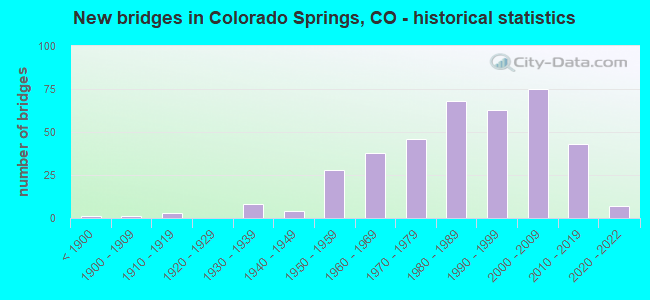
- New bridges - historical statistics
- 1Before 1900
- 11900-1909
- 31910-1919
- 81930-1939
- 41940-1949
- 281950-1959
- 381960-1969
- 461970-1979
- 681980-1989
- 631990-1999
- 752000-2009
- 432010-2019
- 72020-2022
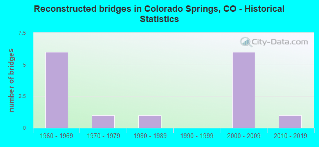
- Reconstructed bridges - Historical Statistics
- 61960-1969
- 11970-1979
- 11980-1989
- 01990-1999
- 62000-2009
- 12010-2019
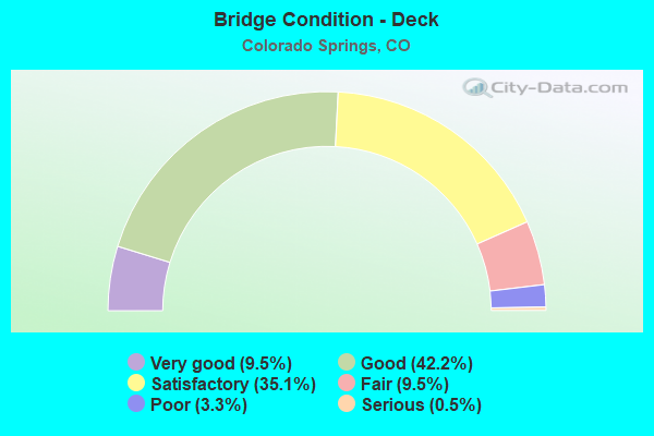
- Bridge Condition - Deck
- 9.5%Very good
- 42.2%Good
- 35.1%Satisfactory
- 9.5%Fair
- 3.3%Poor
- 0.5%Serious
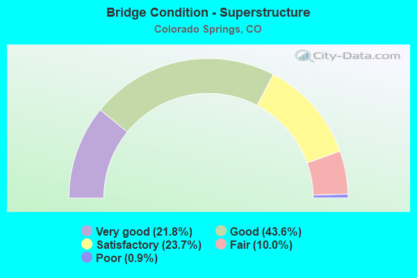
- Bridge Condition - Superstructure
- 21.8%Very good
- 43.6%Good
- 23.7%Satisfactory
- 10.0%Fair
- 0.9%Poor
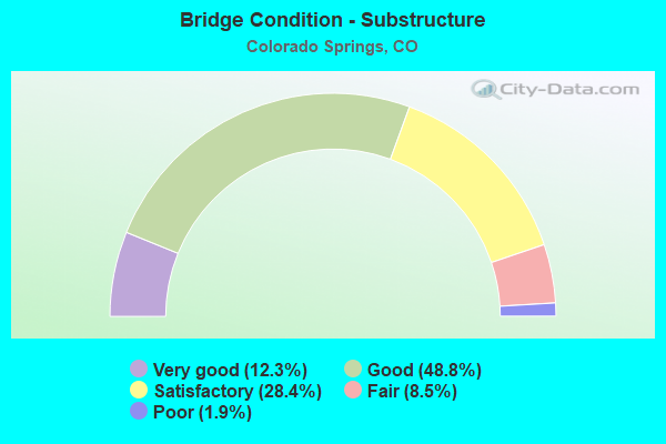
- Bridge Condition - Substructure
- 12.3%Very good
- 48.8%Good
- 28.4%Satisfactory
- 8.5%Fair
- 1.9%Poor
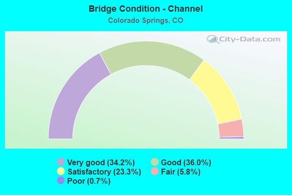
- Bridge Condition - Channel
- 34.2%Very good
- 36.0%Good
- 23.3%Satisfactory
- 5.8%Fair
- 0.7%Poor

- Bridge Condition - Culverts
- 3.5%Very good
- 18.1%Good
- 58.3%Satisfactory
- 16.7%Fair
- 3.5%Poor
Find on map >> Show street view
Structure Number: H-17-DK, Location: SH21 AND I25 INT (Lat: 39.022003, Lng: -104.829986), Route carried "on" structure: Ramp City street , Year Built: 2021, Status: Open, Structure Length: 3.79m (12.43ft), Average Daily Traffic: 1,200 (year 2020), Average Future Daily Traffic: 2,400 (year 2040), Features Intersected: NB SH 21 RAMP, Facility Carried by Structure: NORTH GATE
Minimum Vertical Clearance: 30+ m (98+ ft), Kilometerpoint: 0.000, Lanes on structure: 1, Lanes under structure: 1, Owner: State Highway Agency, Approaching Roadway Width: 7.6m (24.9ft), Skew: 4 degrees, Material/Design: Prestressed concrete, Design/Construction: Stringer/Multi-beam, Number Of Spans In Main Unit: 1, Length of Maximum Span: 35.4m (116.1ft), Curb-To-Curb Width: 7.6m (24.9ft), Out-to-Out Width: 8.5m (27.9ft)
Condition: Deck: Very good, Superstructure: Very good, Substructure: Very good, Operating Rating: 32.7 metric tons, Method Used To Determine Operating Rating: No rating analysis performed, Inventory Rating: 32.7 metric tons, Method Used To Determine Inventory Rating: No rating analysis performed, Structural Evaluation: Equal to present desirable criteria, Deck Geometry: Better than present minimum criteria, Underclear: Better than present minimum criteria, Approach Roadway Alignment: Equal to present desirable criteria, Designated Inspection Frequency: Every 24 months, Inspection Date: October 2021, Deck Structure Type: Concrete Cast-file-Place, Wearing Surface/Protective System: Wearing Surface: Bituminous, Membrane: Built-up, Deck Protection: Epoxy Coated Reinforcing
Find on map >> Show street view
Structure Number: H-17-H, Location: 5.3 MI N OF JCT SH 83 ML (Lat: 39.024064, Lng: -104.831756), Route carried "on" structure: Interstate 25A, Year Built: 1958, Status: Open, Structure Length: 0.64m (2.10ft), Average Daily Traffic: 46,000 (year 2020), Truck Traffic: 10%, Average Future Daily Traffic: 66,240 (year 2040), Design Load: H 20, Features Intersected: SMITH CREEK, Facility Carried by Structure: I 25 ML NBND
Minimum Vertical Clearance: 30+ m (98+ ft), Kilometerpoint: 250.436, Lanes on structure: 4, Base Highway Network: Yes, Owner: State Highway Agency, Approaching Roadway Width: 17.1m (56.1ft), Skew: 10 degrees, Material/Design: Concrete, Design/Construction: Culvert, Number Of Spans In Main Unit: 2, Length of Maximum Span: 3.0m (9.8ft), Out-to-Out Width: 32.6m (107.0ft)
Condition: Channel: Very good, Culverts: Good, Operating Rating: 89.8 metric tons, Method Used To Determine Operating Rating: Field evaluation and documented engineering judgment, Inventory Rating: 89.8 metric tons, Method Used To Determine Inventory Rating: Field evaluation and documented engineering judgment, Structural Evaluation: Better than present minimum criteria, Waterway Adequacy: Equal to present desirable criteria, Approach Roadway Alignment: Equal to present desirable criteria, Designated Inspection Frequency: Every 24 months, Inspection Date: Febuary 2021
Find on map >> Show street view
Structure Number: H-17-I, Location: 4.7 MI N OF JCT SH 83 ML (Lat: 39.013914, Lng: -104.827347), Route carried "on" structure: Interstate 25A, Year Built: 1958, Year Reconstructed: 2008, Status: Open, Structure Length: 0.77m (2.53ft), Average Daily Traffic: 46,000 (year 2020), Truck Traffic: 10%, Average Future Daily Traffic: 66,240 (year 2040), Design Load: HS 20, Features Intersected: MONUMENT CREEK BRANCH, Facility Carried by Structure: I 25 ML SBND
Minimum Vertical Clearance: 30+ m (98+ ft), Kilometerpoint: 249.262, Lanes on structure: 3, Base Highway Network: Yes, Owner: State Highway Agency, Approaching Roadway Width: 14.6m (47.9ft), Skew: 11 degrees, Material/Design: Concrete, Design/Construction: Culvert, Number Of Spans In Main Unit: 2, Length of Maximum Span: 3.7m (12.1ft), Out-to-Out Width: 27.5m (90.2ft)
Condition: Channel: Very good, Culverts: Satisfactory, Operating Rating: 42.1 metric tons, Method Used To Determine Operating Rating: Load and Resistance Factor Rating (LRFR) rating reported by rating factor(RF) method using HL-93 loadings, Inventory Rating: 32.4 metric tons, Method Used To Determine Inventory Rating: Load and Resistance Factor Rating (LRFR) rating reported by rating factor(RF) method using HL-93 loadings, Structural Evaluation: Equal to present minimum criteria, Waterway Adequacy: Equal to present desirable criteria, Approach Roadway Alignment: Equal to present desirable criteria, Length Of Structure Improvement: 1.40m (4.59ft), Designated Inspection Frequency: Every 24 months, Inspection Date: Febuary 2021, Bridge Improvement Cost: $475,000, Roadway Improvement Cost: $48,000, Total Project Cost: $713,000
Find on map >> Show street view
Structure Number: I-17-AG, Location: W. OF I25 S. OF LAKE AVE (Lat: 38.782597, Lng: -104.788500), Route carried "on" structure: Ramp Interstate 25A, Year Built: 1965, Status: Open, Structure Length: 4.23m (13.88ft), Average Daily Traffic: 77,000 (year 2020), Truck Traffic: 10%, Average Future Daily Traffic: 102,410 (year 2040), Design Load: HS 20, Features Intersected: CITY ROAD R, Facility Carried by Structure: I 25 FRONTAGE RD
Minimum Vertical Clearance: 30+ m (98+ ft), Kilometerpoint: 0.072, Lanes on structure: 1, Lanes under structure: 2, Base Highway Network: Yes, Owner: State Highway Agency, Approaching Roadway Width: 6.7m (22.0ft), Skew: 4 degrees, Material/Design: Concrete continuous, Design/Construction: Tee Beam, Number Of Spans In Main Unit: 3, Length of Maximum Span: 15.5m (50.9ft), Curb or Sidewalk Widths: Left: 0.6m (2.0ft), Right: 0.6m (2.0ft), Curb-To-Curb Width: 6.4m (21.0ft), Out-to-Out Width: 7.6m (24.9ft)
Condition: Deck: Fair, Superstructure: Satisfactory, Substructure: Good, Operating Rating: 46.7 metric tons, Method Used To Determine Operating Rating: Load Factor (LF), Inventory Rating: 27.9 metric tons, Method Used To Determine Inventory Rating: Load Factor (LF), Structural Evaluation: Equal to present minimum criteria, Deck Geometry: Somewhat better than minimum adequacy, Underclear: Somewhat better than minimum adequacy, Approach Roadway Alignment: Equal to present desirable criteria, Designated Inspection Frequency: Every 24 months, Inspection Date: August 2020, Deck Structure Type: Other, Wearing Surface/Protective System: Wearing Surface: Bituminous
Find on map >> Show street view
Structure Number: I-17-CD, Location: 1.0 MI N OF JCT I-25 BUS (Lat: 38.932528, Lng: -104.812417), Route carried "on" structure: Interstate 25A, Year Built: 2002, Status: Open, Structure Length: 7.00m (22.97ft), Average Daily Traffic: 62,000 (year 2020), Truck Traffic: 7%, Average Future Daily Traffic: 79,980 (year 2040), Design Load: HL 93, Features Intersected: WOODMEN ROAD, Facility Carried by Structure: I 25 ML NBND
Minimum Vertical Clearance: 30+ m (98+ ft), Kilometerpoint: 239.329, Lanes on structure: 3, Lanes under structure: 10, Base Highway Network: Yes, Owner: State Highway Agency, Approaching Roadway Width: 11.9m (39.0ft), Material/Design: Prestressed concrete continuous, Design/Construction: Box Beam or Girders - Single/Spread, Number Of Spans In Main Unit: 2, Length of Maximum Span: 34.5m (113.2ft), Curb-To-Curb Width: 18.0m (59.1ft), Out-to-Out Width: 19.2m (63.0ft)
Condition: Deck: Good, Superstructure: Very good, Substructure: Satisfactory, Operating Rating: 38.9 metric tons, Method Used To Determine Operating Rating: Load and Resistance Factor Rating (LRFR) rating reported by rating factor(RF) method using HL-93 loadings, Inventory Rating: 29.2 metric tons, Method Used To Determine Inventory Rating: Load and Resistance Factor Rating (LRFR) rating reported by rating factor(RF) method using HL-93 loadings, Structural Evaluation: Equal to present minimum criteria, Deck Geometry: Better than present minimum criteria, Underclear: Somewhat better than minimum adequacy, Approach Roadway Alignment: Equal to present desirable criteria, Length Of Structure Improvement: 7.01m (23.00ft), Designated Inspection Frequency: Every 24 months, Inspection Date: August 2020, Bridge Improvement Cost: $522,000, Roadway Improvement Cost: $52,000, Total Project Cost: $782,000, Deck Structure Type: Concrete Precast Panels, Wearing Surface/Protective System: Wearing Surface: Epoxy Overlay, Deck Protection: Epoxy Coated Reinforcing
Find on map >> Show street view
Structure Number: I-17-CE, Location: 1.5 MI S OF JCT SH 83 (Lat: 38.932544, Lng: -104.812842), Route carried "on" structure: Interstate 25A, Year Built: 2002, Status: Open, Structure Length: 7.00m (22.97ft), Average Daily Traffic: 62,000 (year 2020), Truck Traffic: 7%, Average Future Daily Traffic: 79,980 (year 2040), Design Load: HL 93, Features Intersected: WOODMEN ROAD, Facility Carried by Structure: I 25 ML SBND
Minimum Vertical Clearance: 30+ m (98+ ft), Kilometerpoint: 239.327, Lanes on structure: 3, Lanes under structure: 10, Base Highway Network: Yes, Owner: State Highway Agency, Approaching Roadway Width: 11.9m (39.0ft), Material/Design: Prestressed concrete continuous, Design/Construction: Box Beam or Girders - Single/Spread, Number Of Spans In Main Unit: 2, Length of Maximum Span: 34.5m (113.2ft), Curb-To-Curb Width: 18.0m (59.1ft), Out-to-Out Width: 19.2m (63.0ft)
Condition: Deck: Satisfactory, Superstructure: Good, Substructure: Satisfactory, Operating Rating: 38.9 metric tons, Method Used To Determine Operating Rating: Load and Resistance Factor Rating (LRFR) rating reported by rating factor(RF) method using HL-93 loadings, Inventory Rating: 29.2 metric tons, Method Used To Determine Inventory Rating: Load and Resistance Factor Rating (LRFR) rating reported by rating factor(RF) method using HL-93 loadings, Structural Evaluation: Equal to present minimum criteria, Deck Geometry: Better than present minimum criteria, Underclear: Somewhat better than minimum adequacy, Approach Roadway Alignment: Equal to present desirable criteria, Designated Inspection Frequency: Every 24 months, Inspection Date: August 2020, Deck Structure Type: Concrete Cast-file-Place, Wearing Surface/Protective System: Wearing Surface: Bituminous, Deck Protection: Epoxy Coated Reinforcing
Find on map >> Show street view
Structure Number: I-17-DP, Location: IN COLORADO SPRINGS (Lat: 38.884275, Lng: -104.835547), Route carried "on" structure: Interstate 25A, Year Built: 1959, Status: Open, Structure Length: 4.72m (15.49ft), Average Daily Traffic: 59,000 (year 2020), Truck Traffic: 7%, Average Future Daily Traffic: 72,570 (year 2040), Design Load: HS 20, Features Intersected: ELLSTON ROAD, Facility Carried by Structure: I 25 ML NBND
Minimum Vertical Clearance: 30+ m (98+ ft), Kilometerpoint: 233.472, Lanes on structure: 3, Lanes under structure: 2, Base Highway Network: Yes, Owner: State Highway Agency, Approaching Roadway Width: 15.2m (49.9ft), Skew: 10 degrees, Material/Design: Concrete continuous, Design/Construction: Tee Beam, Number Of Spans In Main Unit: 3, Length of Maximum Span: 18.6m (61.0ft), Curb-To-Curb Width: 13.1m (43.0ft), Out-to-Out Width: 14.2m (46.6ft)
Condition: Deck: Satisfactory, Superstructure: Good, Substructure: Satisfactory, Operating Rating: 65.2 metric tons, Method Used To Determine Operating Rating: Load Factor (LF), Inventory Rating: 39.1 metric tons, Method Used To Determine Inventory Rating: Load Factor (LF), Structural Evaluation: Equal to present minimum criteria, Deck Geometry: High priority of replacement, Underclear: Meets minimum limits, Approach Roadway Alignment: Equal to present desirable criteria, Length Of Structure Improvement: 4.73m (15.52ft), Designated Inspection Frequency: Every 24 months, Inspection Date: August 2020, Bridge Improvement Cost: $190,000, Roadway Improvement Cost: $19,000, Total Project Cost: $285,000, Deck Structure Type: Other, Wearing Surface/Protective System: Wearing Surface: Bituminous
Find on map >> Show street view
Structure Number: I-17-DZ, Location: IN COLORADO SPRINGS (Lat: 38.884286, Lng: -104.835756), Route carried "on" structure: Interstate 25A, Year Built: 1959, Status: Open, Structure Length: 4.72m (15.49ft), Average Daily Traffic: 59,000 (year 2020), Truck Traffic: 7%, Average Future Daily Traffic: 72,570 (year 2040), Design Load: HS 20, Features Intersected: ELLSTON ROAD, Facility Carried by Structure: I25 SB OVR ELLSTON
Minimum Vertical Clearance: 30+ m (98+ ft), Kilometerpoint: 233.471, Lanes on structure: 3, Lanes under structure: 2, Base Highway Network: Yes, Owner: State Highway Agency, Approaching Roadway Width: 13.4m (44.0ft), Skew: 10 degrees, Material/Design: Concrete continuous, Design/Construction: Tee Beam, Number Of Spans In Main Unit: 3, Length of Maximum Span: 18.6m (61.0ft), Curb-To-Curb Width: 17.5m (57.4ft), Out-to-Out Width: 18.7m (61.4ft)
Condition: Deck: Satisfactory, Superstructure: Satisfactory, Substructure: Satisfactory, Operating Rating: 61.2 metric tons, Method Used To Determine Operating Rating: Load Factor (LF), Inventory Rating: 36.7 metric tons, Method Used To Determine Inventory Rating: Load Factor (LF), Structural Evaluation: Equal to present minimum criteria, Deck Geometry: Better than present minimum criteria, Underclear: Meets minimum limits, Approach Roadway Alignment: Equal to present desirable criteria, Designated Inspection Frequency: Every 24 months, Inspection Date: August 2020, Deck Structure Type: Other, Wearing Surface/Protective System: Wearing Surface: Bituminous, Membrane: Built-up
Find on map >> Show street view
Structure Number: I-17-EG, Location: IN COLORADO SPRINGS (Lat: 38.839747, Lng: -104.857803), Route carried "on" structure: US 24A, Year Built: 1964, Status: Open, Structure Length: 2.36m (7.74ft), Average Daily Traffic: 18,000 (year 2020), Truck Traffic: 5%, Average Future Daily Traffic: 20,520 (year 2040), Design Load: HS 20, Features Intersected: FOUNTAIN CREEK, Facility Carried by Structure: US 24 ML WBND
Minimum Vertical Clearance: 30+ m (98+ ft), Kilometerpoint: 253.391, Lanes on structure: 2, Base Highway Network: Yes, Owner: State Highway Agency, Approaching Roadway Width: 10.7m (35.1ft), Skew: 11 degrees, Material/Design: Concrete, Design/Construction: Tee Beam, Number Of Spans In Main Unit: 3, Length of Maximum Span: 9.1m (29.9ft), Curb or Sidewalk Widths: Left: 0.6m (2.0ft), Right: 0.6m (2.0ft), Curb-To-Curb Width: 8.5m (27.9ft), Out-to-Out Width: 9.8m (32.2ft)
Condition: Deck: Good, Superstructure: Satisfactory, Substructure: Satisfactory, Channel: Satisfactory, Operating Rating: 59.1 metric tons, Method Used To Determine Operating Rating: Load Factor (LF), Inventory Rating: 35.4 metric tons, Method Used To Determine Inventory Rating: Load Factor (LF), Structural Evaluation: Equal to present minimum criteria, Deck Geometry: High priority of replacement, Waterway Adequacy: Equal to present desirable criteria, Approach Roadway Alignment: Equal to present desirable criteria, Length Of Structure Improvement: 2.38m (7.81ft), Designated Inspection Frequency: Every 24 months, Inspection Date: January 2021, Bridge Improvement Cost: $381,000, Roadway Improvement Cost: $38,000, Total Project Cost: $419,000 ( Estimate for 2018), Deck Structure Type: Concrete Cast-file-Place, Wearing Surface/Protective System: Wearing Surface: Bituminous
Find on map >> Show street view
Structure Number: I-17-EI, Location: IN COLORADO SPRINGS (Lat: 38.822569, Lng: -104.836097), Route carried "on" structure: Interstate 25A, Year Built: 1959, Status: Open, Structure Length: 0.88m (2.89ft), Average Daily Traffic: 123,000 (year 2020), Truck Traffic: 9%, Average Future Daily Traffic: 159,900 (year 2040), Design Load: H 20, Features Intersected: DRAW, Facility Carried by Structure: I 25 ML
Minimum Vertical Clearance: 30+ m (98+ ft), Kilometerpoint: 226.425, Lanes on structure: 6, Base Highway Network: Yes, Owner: State Highway Agency, Approaching Roadway Width: 30.5m (100.1ft), Skew: 30 degrees, Material/Design: Concrete, Design/Construction: Culvert, Number Of Spans In Main Unit: 2, Length of Maximum Span: 4.3m (14.1ft), Out-to-Out Width: 49.6m (162.7ft)
Condition: Channel: Very good, Culverts: Satisfactory, Operating Rating: 32.4 metric tons, Method Used To Determine Operating Rating: Load and Resistance Factor Rating (LRFR) rating reported by rating factor(RF) method using HL-93 loadings, Inventory Rating: 22.7 metric tons, Method Used To Determine Inventory Rating: Load and Resistance Factor Rating (LRFR) rating reported by rating factor(RF) method using HL-93 loadings, Structural Evaluation: Somewhat better than minimum adequacy, Waterway Adequacy: Equal to present desirable criteria, Approach Roadway Alignment: Equal to present desirable criteria, Designated Inspection Frequency: Every 24 months, Inspection Date: November 2020
Find on map >> Show street view
Structure Number: I-17-EQ, Location: IN COLORADO SPRINGS (Lat: 38.839653, Lng: -104.857861), Route carried "on" structure: US 24A, Year Built: 1964, Status: Open, Structure Length: 2.37m (7.78ft), Average Daily Traffic: 18,000 (year 2020), Truck Traffic: 5%, Average Future Daily Traffic: 20,520 (year 2040), Design Load: HS 20, Features Intersected: FOUNTAIN CREEK, Facility Carried by Structure: US 24 ML EBND
Minimum Vertical Clearance: 30+ m (98+ ft), Kilometerpoint: 253.393, Lanes on structure: 2, Base Highway Network: Yes, Owner: State Highway Agency, Approaching Roadway Width: 11.0m (36.1ft), Skew: 11 degrees, Material/Design: Concrete, Design/Construction: Tee Beam, Number Of Spans In Main Unit: 3, Length of Maximum Span: 9.1m (29.9ft), Curb or Sidewalk Widths: Left: 0.6m (2.0ft), Right: 0.6m (2.0ft), Curb-To-Curb Width: 8.5m (27.9ft), Out-to-Out Width: 9.8m (32.2ft)
Condition: Deck: Satisfactory, Superstructure: Satisfactory, Substructure: Satisfactory, Channel: Good, Operating Rating: 59.1 metric tons, Method Used To Determine Operating Rating: Load Factor (LF), Inventory Rating: 35.4 metric tons, Method Used To Determine Inventory Rating: Load Factor (LF), Structural Evaluation: Equal to present minimum criteria, Deck Geometry: High priority of replacement, Waterway Adequacy: Equal to present desirable criteria, Approach Roadway Alignment: Equal to present desirable criteria, Length Of Structure Improvement: 2.37m (7.78ft), Designated Inspection Frequency: Every 24 months, Inspection Date: January 2021, Bridge Improvement Cost: $238,000, Roadway Improvement Cost: $24,000, Total Project Cost: $262,000 ( Estimate for 2018), Deck Structure Type: Concrete Cast-file-Place, Wearing Surface/Protective System: Wearing Surface: Bituminous
Find on map >> Show street view
Structure Number: I-17-EX, Location: IN COLORADO SPRINGS (Lat: 38.839653, Lng: -104.857861), Route carried "on" structure: US 24A, Year Built: 2020, Status: Open, Structure Length: 2.36m (7.74ft), Average Daily Traffic: 36,000 (year 2020), Truck Traffic: 5%, Average Future Daily Traffic: 41,040 (year 2040), Design Load: HL 93, Features Intersected: FOUNTAIN CREEK, Facility Carried by Structure: US 24 ML
Minimum Vertical Clearance: 30+ m (98+ ft), Kilometerpoint: 253.393, Lanes on structure: 5, Base Highway Network: Yes, Owner: State Highway Agency, Approaching Roadway Width: 21.3m (69.9ft), Skew: 21 degrees, Material/Design: Concrete, Design/Construction: Tee Beam, Number Of Spans In Main Unit: 3, Length of Maximum Span: 9.1m (29.9ft), Curb or Sidewalk Widths: Left: 0.6m (2.0ft), Right: 0.6m (2.0ft), Curb-To-Curb Width: 21.3m (69.9ft), Out-to-Out Width: 22.6m (74.1ft)
Condition: Deck: Satisfactory, Superstructure: Satisfactory, Substructure: Satisfactory, Channel: Satisfactory, Operating Rating: 35.6 metric tons, Method Used To Determine Operating Rating: Load and Resistance Factor Rating (LRFR) rating reported by rating factor(RF) method using HL-93 loadings, Inventory Rating: 29.2 metric tons, Method Used To Determine Inventory Rating: Load and Resistance Factor Rating (LRFR) rating reported by rating factor(RF) method using HL-93 loadings, Structural Evaluation: Equal to present minimum criteria, Deck Geometry: Meets minimum limits, Waterway Adequacy: Equal to present desirable criteria, Approach Roadway Alignment: Equal to present desirable criteria, Length Of Structure Improvement: 2.37m (7.78ft), Designated Inspection Frequency: Every 24 months, Inspection Date: January 2021, Deck Structure Type: Concrete Cast-file-Place, Wearing Surface/Protective System: Wearing Surface: Bituminous
Find on map >> Show street view
Structure Number: I-17-FA, Location: IN COLORADO SPRINGS (Lat: 38.829694, Lng: -104.837778), Route carried "on" structure: US 24A, Year Built: 2015, Status: Open, Structure Length: 4.54m (14.90ft), Average Daily Traffic: 38,000 (year 2020), Truck Traffic: 6%, Average Future Daily Traffic: 41,420 (year 2040), Design Load: HL 93, Features Intersected: FOUNTAIN CREEK, Facility Carried by Structure: US 24 ML
Minimum Vertical Clearance: 30+ m (98+ ft), Kilometerpoint: 255.469, Lanes on structure: 7, Base Highway Network: Yes, Owner: State Highway Agency, Approaching Roadway Width: 30.4m (99.7ft), Skew: 22 degrees, Material/Design: Prestressed concrete continuous, Design/Construction: Box Beam or Girders - Single/Spread, Number Of Spans In Main Unit: 2, Length of Maximum Span: 24.6m (80.7ft), Curb-To-Curb Width: 31.1m (102.0ft), Out-to-Out Width: 33.2m (108.9ft)
Condition: Deck: Good, Superstructure: Good, Substructure: Good, Channel: Very good, Operating Rating: 48.6 metric tons, Method Used To Determine Operating Rating: Load and Resistance Factor Rating (LRFR) rating reported by rating factor(RF) method using HL-93 loadings, Inventory Rating: 35.6 metric tons, Method Used To Determine Inventory Rating: Load and Resistance Factor Rating (LRFR) rating reported by rating factor(RF) method using HL-93 loadings, Structural Evaluation: Better than present minimum criteria, Deck Geometry: Equal to present minimum criteria, Waterway Adequacy: Equal to present desirable criteria, Approach Roadway Alignment: Equal to present desirable criteria, Designated Inspection Frequency: Every 24 months, Inspection Date: January 2021, Deck Structure Type: Concrete Precast Panels, Wearing Surface/Protective System: Wearing Surface: Bituminous, Membrane: Built-up, Deck Protection: Epoxy Coated Reinforcing
Find on map >> Show street view
Structure Number: I-17-FJ, Location: IN COLORADO SPRINGS (Lat: 38.815019, Lng: -104.825100), Route carried "on" structure: Interstate 25A, Year Built: 2002, Status: Open, Structure Length: 28.96m (95.01ft), Average Daily Traffic: 88,000 (year 2020), Truck Traffic: 9%, Average Future Daily Traffic: 113,520 (year 2040), Design Load: HS 25 or greater, Features Intersected: CHEYENNE CRK/NEVADA AVE., Facility Carried by Structure: I25 ML
Minimum Vertical Clearance: 30+ m (98+ ft), Kilometerpoint: 225.075, Lanes on structure: 6, Lanes under structure: 12, Base Highway Network: Yes, Owner: State Highway Agency, Approaching Roadway Width: 30.5m (100.1ft), Skew: 30 degrees, Material/Design: Prestressed concrete continuous, Design/Construction: Box Beam or Girders - Single/Spread, Number Of Spans In Main Unit: 8, Length of Maximum Span: 38.0m (124.7ft), Curb-To-Curb Width: 36.0m (118.1ft), Out-to-Out Width: 38.1m (125.0ft)
Condition: Deck: Satisfactory, Superstructure: Satisfactory, Substructure: Good, Channel: Very good, Operating Rating: 58.0 metric tons, Method Used To Determine Operating Rating: Load Factor (LF), Inventory Rating: 22.3 metric tons, Method Used To Determine Inventory Rating: Load Factor (LF), Structural Evaluation: Somewhat better than minimum adequacy, Deck Geometry: Superior to present desirable criteria, Underclear: Superior to present desirable criteria, Waterway Adequacy: Superior to present desirable criteria, Approach Roadway Alignment: Equal to present desirable criteria, Designated Inspection Frequency: Every 24 months, Inspection Date: November 2020, Deck Structure Type: Concrete Cast-file-Place, Wearing Surface/Protective System: Wearing Surface: Monolithic Concrete, Deck Protection: Epoxy Coated Reinforcing
Find on map >> Show street view
Structure Number: I-17-FM, Location: S. 31ST ST. (Lat: 38.852036, Lng: -104.872547), Route carried "on" structure: Business US 24E, Year Built: 1964, Status: Open, Structure Length: 2.38m (7.81ft), Average Daily Traffic: 6,100 (year 2018), Truck Traffic: 3%, Average Future Daily Traffic: 6,344 (year 2038), Design Load: HS 20, Features Intersected: FOUNTAIN CREEK, Facility Carried by Structure: US 24 BUSINESS RT
Minimum Vertical Clearance: 30+ m (98+ ft), Kilometerpoint: 0.132, Lanes on structure: 4, Owner: State Highway Agency, Approaching Roadway Width: 16.5m (54.1ft), Skew: 32 degrees, Material/Design: Concrete, Design/Construction: Tee Beam, Number Of Spans In Main Unit: 3, Length of Maximum Span: 9.1m (29.9ft), Curb or Sidewalk Widths: Left: 0.6m (2.0ft), Right: 0.6m (2.0ft), Curb-To-Curb Width: 16.5m (54.1ft), Out-to-Out Width: 18.9m (62.0ft)
Condition: Deck: Satisfactory, Superstructure: Satisfactory, Substructure: Fair, Channel: Very good, Operating Rating: 59.0 metric tons, Method Used To Determine Operating Rating: Load Factor (LF), Inventory Rating: 35.3 metric tons, Method Used To Determine Inventory Rating: Load Factor (LF), Structural Evaluation: Somewhat better than minimum adequacy, Deck Geometry: Meets minimum limits, Waterway Adequacy: Equal to present desirable criteria, Approach Roadway Alignment: Equal to present desirable criteria, Designated Inspection Frequency: Every 24 months, Inspection Date: January 2021, Deck Structure Type: Concrete Cast-file-Place, Wearing Surface/Protective System: Wearing Surface: Bituminous
Find on map >> Show street view
Structure Number: I-17-GC, Location: 1.5 MI E OF MANITOU SPRIN (Lat: 38.855608, Lng: -104.881917), Route carried "on" structure: Business US 24E, Year Built: 1969, Status: Open, Structure Length: 2.12m (6.96ft), Average Daily Traffic: 7,334 (year 2020), Truck Traffic: 3%, Average Future Daily Traffic: 32,980 (year 2031), Design Load: HS 20, Features Intersected: FOUNTAIN CREEK, Facility Carried by Structure: US 24 BUS RT-OFFRA
Minimum Vertical Clearance: 30+ m (98+ ft), Kilometerpoint: 250.625, Lanes on structure: 2, Owner: State Highway Agency, Approaching Roadway Width: 9.1m (29.9ft), Material/Design: Concrete, Design/Construction: Tee Beam, Number Of Spans In Main Unit: 3, Length of Maximum Span: 6.6m (21.7ft), Curb-To-Curb Width: 9.9m (32.5ft), Out-to-Out Width: 10.7m (35.1ft)
Condition: Deck: Good, Superstructure: Good, Substructure: Satisfactory, Channel: Satisfactory, Operating Rating: 57.6 metric tons, Method Used To Determine Operating Rating: Load Factor (LF), Inventory Rating: 34.5 metric tons, Method Used To Determine Inventory Rating: Load Factor (LF), Structural Evaluation: Equal to present minimum criteria, Deck Geometry: Meets minimum limits, Waterway Adequacy: Equal to present desirable criteria, Approach Roadway Alignment: Equal to present desirable criteria, Designated Inspection Frequency: Every 24 months, Inspection Date: January 2021, Deck Structure Type: Concrete Cast-file-Place, Wearing Surface/Protective System: Wearing Surface: Bituminous
Find on map >> Show street view
Structure Number: I-17-GK, Location: 1.4 MI N OF JCT I-25 BUS (Lat: 38.938403, Lng: -104.812542), Route carried "on" structure: Interstate 25A, Year Built: 2002, Status: Open, Structure Length: 6.96m (22.83ft), Average Daily Traffic: 58,000 (year 2020), Truck Traffic: 10%, Average Future Daily Traffic: 81,200 (year 2040), Design Load: HS 25 or greater, Features Intersected: PINE CREEK, Facility Carried by Structure: I 25 ML NBND
Minimum Vertical Clearance: 30+ m (98+ ft), Kilometerpoint: 239.984, Lanes on structure: 4, Base Highway Network: Yes, Owner: State Highway Agency, Approaching Roadway Width: 24.7m (81.0ft), Skew: 10 degrees, Material/Design: Steel continuous, Design/Construction: Frame, Number Of Spans In Main Unit: 3, Length of Maximum Span: 34.6m (113.5ft), Curb-To-Curb Width: 22.8m (74.8ft), Out-to-Out Width: 24.0m (78.7ft)
Condition: Deck: Satisfactory, Superstructure: Good, Substructure: Good, Channel: Very good, Operating Rating: 71.9 metric tons, Method Used To Determine Operating Rating: Load Factor (LF), Inventory Rating: 43.2 metric tons, Method Used To Determine Inventory Rating: Load Factor (LF), Structural Evaluation: Better than present minimum criteria, Deck Geometry: Superior to present desirable criteria, Waterway Adequacy: Equal to present desirable criteria, Approach Roadway Alignment: Equal to present desirable criteria, Designated Inspection Frequency: Every 24 months, Inspection Date: August 2020, Deck Structure Type: Concrete Precast Panels, Wearing Surface/Protective System: Wearing Surface: Epoxy Overlay, Deck Protection: Epoxy Coated Reinforcing
Find on map >> Show street view
Structure Number: I-17-GO, Location: 3.5 MI N OF FORT CARSON (Lat: 38.797097, Lng: -104.822047), Route carried "on" structure: State highway 115A, Year Built: 1971, Status: Open, Structure Length: 6.77m (22.21ft), Average Daily Traffic: 34,000 (year 2020), Truck Traffic: 3%, Average Future Daily Traffic: 40,800 (year 2040), Design Load: HS 20, Features Intersected: US 85 ML, Facility Carried by Structure: SH 115 ML + US 85
Minimum Vertical Clearance: 30+ m (98+ ft), Kilometerpoint: 73.565, Lanes on structure: 4, Lanes under structure: 6, Base Highway Network: Yes, Owner: State Highway Agency, Approaching Roadway Width: 23.2m (76.1ft), Skew: 31 degrees, Material/Design: Concrete continuous, Design/Construction: Box Beam or Girders - Single/Spread, Number Of Spans In Main Unit: 2, Length of Maximum Span: 36.6m (120.1ft), Curb-To-Curb Width: 30.8m (101.0ft), Out-to-Out Width: 31.9m (104.7ft)
Condition: Deck: Satisfactory, Superstructure: Satisfactory, Substructure: Satisfactory, Operating Rating: 63.8 metric tons, Method Used To Determine Operating Rating: Load Factor (LF), Inventory Rating: 38.2 metric tons, Method Used To Determine Inventory Rating: Load Factor (LF), Structural Evaluation: Equal to present minimum criteria, Deck Geometry: Superior to present desirable criteria, Underclear: Better than present minimum criteria, Approach Roadway Alignment: Equal to present desirable criteria, Designated Inspection Frequency: Every 24 months, Inspection Date: November 2020, Deck Structure Type: Concrete Cast-file-Place, Wearing Surface/Protective System: Wearing Surface: Bituminous, Membrane: Built-up
Find on map >> Show street view
Structure Number: I-17-GV, Location: 1.4 MI N OF JCT I-25 BUS (Lat: 38.938364, Lng: -104.813014), Route carried "on" structure: Interstate 25A, Year Built: 2002, Status: Open, Structure Length: 6.96m (22.83ft), Average Daily Traffic: 58,000 (year 2020), Truck Traffic: 10%, Average Future Daily Traffic: 81,200 (year 2040), Design Load: HS 25 or greater, Features Intersected: PINE CREEK, Facility Carried by Structure: I 25 ML SBND
Minimum Vertical Clearance: 30+ m (98+ ft), Kilometerpoint: 239.982, Lanes on structure: 4, Base Highway Network: Yes, Owner: State Highway Agency, Approaching Roadway Width: 19.5m (64.0ft), Skew: 10 degrees, Material/Design: Steel continuous, Design/Construction: Frame, Number Of Spans In Main Unit: 3, Length of Maximum Span: 34.6m (113.5ft), Curb-To-Curb Width: 20.4m (66.9ft), Out-to-Out Width: 21.6m (70.9ft)
Condition: Deck: Good, Superstructure: Good, Substructure: Good, Channel: Very good, Operating Rating: 82.7 metric tons, Method Used To Determine Operating Rating: Load Factor (LF), Inventory Rating: 49.7 metric tons, Method Used To Determine Inventory Rating: Load Factor (LF), Structural Evaluation: Better than present minimum criteria, Deck Geometry: Equal to present minimum criteria, Waterway Adequacy: Equal to present desirable criteria, Approach Roadway Alignment: Equal to present desirable criteria, Designated Inspection Frequency: Every 24 months, Inspection Date: August 2020, Deck Structure Type: Concrete Precast Panels, Wearing Surface/Protective System: Wearing Surface: Epoxy Overlay, Membrane: Other, Deck Protection: Epoxy Coated Reinforcing
Find on map >> Show street view
Structure Number: I-17-GY, Location: 1.8 MI S OF JCT SH 83 (Lat: 38.927192, Lng: -104.813242), Route carried "on" structure: Interstate 25A, Year Built: 2004, Status: Open, Structure Length: 5.75m (18.86ft), Average Daily Traffic: 62,000 (year 2020), Truck Traffic: 7%, Average Future Daily Traffic: 79,980 (year 2040), Design Load: HS 25 or greater, Features Intersected: COTTONWOOD CREEK, Facility Carried by Structure: I 25 ML NBND
Minimum Vertical Clearance: 30+ m (98+ ft), Kilometerpoint: 238.732, Lanes on structure: 4, Base Highway Network: Yes, Owner: State Highway Agency, Approaching Roadway Width: 15.8m (51.8ft), Skew: 13 degrees, Material/Design: Prestressed concrete continuous, Design/Construction: Stringer/Multi-beam, Number Of Spans In Main Unit: 2, Length of Maximum Span: 28.3m (92.8ft), Curb-To-Curb Width: 20.4m (66.9ft), Out-to-Out Width: 21.6m (70.9ft)
Condition: Deck: Satisfactory, Superstructure: Very good, Substructure: Good, Channel: Good, Operating Rating: 71.8 metric tons, Method Used To Determine Operating Rating: Load Factor (LF), Inventory Rating: 43.1 metric tons, Method Used To Determine Inventory Rating: Load Factor (LF), Structural Evaluation: Better than present minimum criteria, Deck Geometry: Equal to present minimum criteria, Waterway Adequacy: Equal to present desirable criteria, Approach Roadway Alignment: Equal to present desirable criteria, Designated Inspection Frequency: Every 24 months, Inspection Date: August 2020, Deck Structure Type: Concrete Precast Panels, Wearing Surface/Protective System: Wearing Surface: Other, Membrane: Built-up, Deck Protection: Epoxy Coated Reinforcing
Find on map >> Show street view
Structure Number: I-17-H, Location: 0.8 MI SE OF MANITOU SPRI (Lat: 38.856431, Lng: -104.884806), Route carried "on" structure: Business US 24E, Year Built: 1934, Status: Open, Structure Length: 2.04m (6.69ft), Average Daily Traffic: 14,668 (year 2020), Truck Traffic: 3%, Average Future Daily Traffic: 29,380 (year 2031), Design Load: H 15, Features Intersected: FOUNTAIN CREEK, Facility Carried by Structure: US 24 BUSINESS RT
Minimum Vertical Clearance: 30+ m (98+ ft), Kilometerpoint: 0.884, Lanes on structure: 4, Owner: State Highway Agency, Approaching Roadway Width: 16.8m (55.1ft), Skew: 6 degrees, Material/Design: Steel, Design/Construction: Stringer/Multi-beam, Number Of Spans In Main Unit: 1, Length of Maximum Span: 18.0m (59.1ft), Curb or Sidewalk Widths: Left: 0.0m, Right: 1.5m (4.9ft), Curb-To-Curb Width: 12.2m (40.0ft), Out-to-Out Width: 14.6m (47.9ft)
Condition: Deck: Poor, Superstructure: Satisfactory, Substructure: Satisfactory, Channel: Satisfactory, Operating Rating: 28.0 metric tons, Method Used To Determine Operating Rating: Load Factor (LF), Inventory Rating: 16.8 metric tons, Method Used To Determine Inventory Rating: Load Factor (LF), Structural Evaluation: Meets minimum limits, Deck Geometry: High priority of replacement, Waterway Adequacy: Equal to present minimum criteria, Approach Roadway Alignment: Equal to present desirable criteria, Designated Inspection Frequency: Every 24 months, Inspection Date: January 2021, Deck Structure Type: Concrete Cast-file-Place, Wearing Surface/Protective System: Wearing Surface: Bituminous
Find on map >> Show street view
Structure Number: I-17-HF, Location: 1.8 MI S OF JCT SH 83 (Lat: 38.927050, Lng: -104.813722), Route carried "on" structure: Interstate 25A, Year Built: 2004, Status: Open, Structure Length: 5.75m (18.86ft), Average Daily Traffic: 62,000 (year 2020), Truck Traffic: 7%, Average Future Daily Traffic: 79,980 (year 2040), Design Load: HS 25 or greater, Features Intersected: COTTONWOOD CREEK, Facility Carried by Structure: I 25 ML SBND
Minimum Vertical Clearance: 30+ m (98+ ft), Kilometerpoint: 238.711, Lanes on structure: 4, Base Highway Network: Yes, Owner: State Highway Agency, Approaching Roadway Width: 20.7m (67.9ft), Skew: 13 degrees, Material/Design: Prestressed concrete continuous, Design/Construction: Stringer/Multi-beam, Number Of Spans In Main Unit: 2, Length of Maximum Span: 28.3m (92.8ft), Curb-To-Curb Width: 20.4m (66.9ft), Out-to-Out Width: 21.6m (70.9ft)
Condition: Deck: Satisfactory, Superstructure: Satisfactory, Substructure: Good, Channel: Good, Operating Rating: 71.8 metric tons, Method Used To Determine Operating Rating: Load Factor (LF), Inventory Rating: 43.0 metric tons, Method Used To Determine Inventory Rating: Load Factor (LF), Structural Evaluation: Equal to present minimum criteria, Deck Geometry: Equal to present minimum criteria, Waterway Adequacy: Equal to present desirable criteria, Approach Roadway Alignment: Equal to present desirable criteria, Designated Inspection Frequency: Every 24 months, Inspection Date: August 2020, Deck Structure Type: Concrete Precast Panels, Wearing Surface/Protective System: Wearing Surface: Other, Deck Protection: Epoxy Coated Reinforcing
Find on map >> Show street view
Structure Number: I-17-HI, Location: 2 MI W OF JCT I-25 (Lat: 38.765744, Lng: -104.812858), Route carried "on" structure: County highway , Year Built: 1977, Status: Open, Structure Length: 6.78m (22.24ft), Average Daily Traffic: 16,612 (year 2021), Truck Traffic: 8%, Average Future Daily Traffic: 21,762 (year 2041), Design Load: HS 20, Features Intersected: SH 115 ML, Facility Carried by Structure: Academy Blvd
Minimum Vertical Clearance: 30+ m (98+ ft), Kilometerpoint: 0.307, Lanes on structure: 7, Lanes under structure: 4, Owner: State Highway Agency, Approaching Roadway Width: 31.7m (104.0ft), Skew: 20 degrees, Material/Design: Steel continuous, Design/Construction: Stringer/Multi-beam, Number Of Spans In Main Unit: 2, Length of Maximum Span: 34.7m (113.8ft), Curb-To-Curb Width: 33.0m (108.3ft), Out-to-Out Width: 33.8m (110.9ft)
Condition: Deck: Good, Superstructure: Good, Substructure: Good, Operating Rating: 69.2 metric tons, Method Used To Determine Operating Rating: Load Factor (LF), Inventory Rating: 41.5 metric tons, Method Used To Determine Inventory Rating: Load Factor (LF), Structural Evaluation: Better than present minimum criteria, Deck Geometry: Better than present minimum criteria, Underclear: Better than present minimum criteria, Approach Roadway Alignment: Equal to present desirable criteria, Designated Inspection Frequency: Every 24 months, Inspection Date: November 2020, Deck Structure Type: Concrete Cast-file-Place, Wearing Surface/Protective System: Wearing Surface: Bituminous, Membrane: Preformed Fabric
Find on map >> Show street view
Structure Number: I-17-HQ, Location: EAST OF MURRAY BLVD (Lat: 38.811133, Lng: -104.746797), Route carried "on" structure: US 24H, Year Built: 1975, Status: Open, Structure Length: 6.39m (20.96ft), Average Daily Traffic: 15,000 (year 2020), Truck Traffic: 7%, Average Future Daily Traffic: 18,900 (year 2040), Design Load: HS 20, Features Intersected: SAND CREEK, Facility Carried by Structure: US 24 ML WBND
Minimum Vertical Clearance: 30+ m (98+ ft), Kilometerpoint: 6.487, Lanes on structure: 2, Base Highway Network: Yes, Owner: State Highway Agency, Approaching Roadway Width: 9.8m (32.2ft), Skew: 11 degrees, Material/Design: Prestressed concrete continuous, Design/Construction: Stringer/Multi-beam, Number Of Spans In Main Unit: 2, Length of Maximum Span: 31.5m (103.3ft), Curb or Sidewalk Widths: Left: 0.0m, Right: 1.5m (4.9ft), Curb-To-Curb Width: 15.8m (51.8ft), Out-to-Out Width: 18.1m (59.4ft)
Condition: Deck: Good, Superstructure: Very good, Substructure: Satisfactory, Channel: Satisfactory, Operating Rating: 50.1 metric tons, Method Used To Determine Operating Rating: Load Factor (LF), Inventory Rating: 29.9 metric tons, Method Used To Determine Inventory Rating: Load Factor (LF), Structural Evaluation: Equal to present minimum criteria, Deck Geometry: Superior to present desirable criteria, Waterway Adequacy: Equal to present desirable criteria, Approach Roadway Alignment: Equal to present desirable criteria, Designated Inspection Frequency: Every 24 months, Inspection Date: January 2021, Deck Structure Type: Concrete Cast-file-Place, Wearing Surface/Protective System: Wearing Surface: Bituminous, Membrane: Built-up
Find on map >> Show street view
Structure Number: I-17-HS, Location: EAST OF MURRAY BLVD (Lat: 38.810944, Lng: -104.746947), Route carried "on" structure: US 24H, Year Built: 1975, Status: Open, Structure Length: 6.39m (20.96ft), Average Daily Traffic: 15,000 (year 2020), Truck Traffic: 7%, Average Future Daily Traffic: 18,900 (year 2040), Design Load: HS 20, Features Intersected: SAND CREEK, Facility Carried by Structure: US 24 ML EBND
Minimum Vertical Clearance: 30+ m (98+ ft), Kilometerpoint: 6.486, Lanes on structure: 2, Base Highway Network: Yes, Owner: State Highway Agency, Approaching Roadway Width: 9.1m (29.9ft), Skew: 11 degrees, Material/Design: Prestressed concrete continuous, Design/Construction: Stringer/Multi-beam, Number Of Spans In Main Unit: 2, Length of Maximum Span: 31.5m (103.3ft), Curb or Sidewalk Widths: Left: 0.0m, Right: 1.5m (4.9ft), Curb-To-Curb Width: 15.8m (51.8ft), Out-to-Out Width: 18.1m (59.4ft)
Condition: Deck: Good, Superstructure: Very good, Substructure: Good, Channel: Good, Operating Rating: 54.1 metric tons, Method Used To Determine Operating Rating: Load Factor (LF), Inventory Rating: 32.4 metric tons, Method Used To Determine Inventory Rating: Load Factor (LF), Structural Evaluation: Better than present minimum criteria, Deck Geometry: Superior to present desirable criteria, Waterway Adequacy: Equal to present desirable criteria, Approach Roadway Alignment: Equal to present desirable criteria, Designated Inspection Frequency: Every 24 months, Inspection Date: January 2021, Deck Structure Type: Concrete Cast-file-Place, Wearing Surface/Protective System: Wearing Surface: Bituminous, Membrane: Built-up
Find on map >> Show street view
Structure Number: I-17-ID, Location: 0.4 MI SE OF PIKES PEAK T (Lat: 38.893283, Lng: -104.967711), Route carried "on" structure: US 24A, Year Built: 1965, Status: Open, Structure Length: 0.75m (2.46ft), Average Daily Traffic: 11,500 (year 2020), Truck Traffic: 4%, Average Future Daily Traffic: 13,225 (year 2040), Design Load: HS 20, Features Intersected: FOUNTAIN CREEK, Facility Carried by Structure: US 24 ML WBND
Minimum Vertical Clearance: 30+ m (98+ ft), Kilometerpoint: 241.204, Lanes on structure: 2, Base Highway Network: Yes, Owner: State Highway Agency, Approaching Roadway Width: 8.8m (28.9ft), Skew: 23 degrees, Material/Design: Concrete, Design/Construction: Culvert, Number Of Spans In Main Unit: 2, Length of Maximum Span: 3.5m (11.5ft), Out-to-Out Width: 16.4m (53.8ft)
Condition: Channel: Satisfactory, Culverts: Fair, Operating Rating: 36.3 metric tons, Method Used To Determine Operating Rating: Field evaluation and documented engineering judgment, Inventory Rating: 32.7 metric tons, Method Used To Determine Inventory Rating: Field evaluation and documented engineering judgment, Structural Evaluation: Somewhat better than minimum adequacy, Waterway Adequacy: Better than present minimum criteria, Approach Roadway Alignment: Equal to present desirable criteria, Designated Inspection Frequency: Every 24 months, Inspection Date: January 2021
Find on map >> Show street view
Structure Number: I-17-IG, Location: ECHO LANE US HIGHWAY 24 (Lat: 38.852264, Lng: -104.872514), Route carried "on" structure: US 24E, Year Built: 1960, Status: Open, Structure Length: 0.76m (2.49ft), Average Daily Traffic: 6,100 (year 2018), Truck Traffic: 3%, Average Future Daily Traffic: 6,344 (year 2038), Features Intersected: CAMP CREEK, Facility Carried by Structure: US 24 ML
Minimum Vertical Clearance: 30+ m (98+ ft), Kilometerpoint: 0.132, Lanes on structure: 12, Owner: State Highway Agency, Approaching Roadway Width: 18.6m (61.0ft), Material/Design: Steel, Design/Construction: Culvert, Number Of Spans In Main Unit: 1, Length of Maximum Span: 7.6m (24.9ft), Curb or Sidewalk Widths: Left: 0.9m (3.0ft), Right: 1.4m (4.6ft), Out-to-Out Width: 375.8m (1,232.9ft)
Condition: Channel: Satisfactory, Culverts: Good, Inventory Rating: 64.1 metric tons, Method Used To Determine Inventory Rating: Load Factor (LF), Structural Evaluation: Better than present minimum criteria, Waterway Adequacy: Equal to present desirable criteria, Approach Roadway Alignment: Equal to present desirable criteria, Designated Inspection Frequency: Every 24 months, Inspection Date: January 2021
Find on map >> Show street view
Structure Number: I-17-IJ, Location: 1.4 MI N OF SH 83 SPUR (Lat: 38.969186, Lng: -104.805319), Route carried "on" structure: City street , Year Built: 1987, Status: Open, Structure Length: 6.77m (22.21ft), Average Daily Traffic: 13,577 (year 2021), Truck Traffic: 10%, Average Future Daily Traffic: 17,785 (year 2041), Features Intersected: I 25 ML, Facility Carried by Structure: BRIARGATE PARKWAY
Minimum Vertical Clearance: 30+ m (98+ ft), Kilometerpoint: 0.640, Lanes on structure: 3, Lanes under structure: 7, Owner: State Highway Agency, Approaching Roadway Width: 17.7m (58.1ft), Material/Design: Prestressed concrete continuous, Design/Construction: Box Beam or Girders - Multiple, Number Of Spans In Main Unit: 2, Length of Maximum Span: 33.8m (110.9ft), Curb-To-Curb Width: 21.8m (71.5ft), Out-to-Out Width: 22.9m (75.1ft)
Condition: Deck: Good, Superstructure: Very good, Substructure: Very good, Operating Rating: 66.4 metric tons, Method Used To Determine Operating Rating: Load Factor (LF), Inventory Rating: 39.8 metric tons, Method Used To Determine Inventory Rating: Load Factor (LF), Structural Evaluation: Equal to present desirable criteria, Deck Geometry: Superior to present desirable criteria, Underclear: Equal to present minimum criteria, Approach Roadway Alignment: Equal to present desirable criteria, Designated Inspection Frequency: Every 24 months, Inspection Date: Febuary 2021, Deck Structure Type: Concrete Cast-file-Place, Wearing Surface/Protective System: Wearing Surface: Bituminous, Membrane: Preformed Fabric, Deck Protection: Epoxy Coated Reinforcing
Find on map >> Show street view
Structure Number: I-17-IX, Location: US24 HANCOCK TO QUIVIRA (Lat: 38.811942, Lng: -104.789731), Route carried "on" structure: US 24H, Year Built: 1993, Status: Open, Structure Length: 7.09m (23.26ft), Average Daily Traffic: 21,000 (year 2020), Truck Traffic: 7%, Average Future Daily Traffic: 27,510 (year 2040), Design Load: HS 20, Features Intersected: UNION BLVD, Facility Carried by Structure: US 24 ML WBND
Minimum Vertical Clearance: 30+ m (98+ ft), Kilometerpoint: 2.338, Lanes on structure: 3, Lanes under structure: 8, Base Highway Network: Yes, Owner: State Highway Agency, Approaching Roadway Width: 17.1m (56.1ft), Skew: 10 degrees, Material/Design: Prestressed concrete continuous, Design/Construction: Stringer/Multi-beam, Number Of Spans In Main Unit: 2, Length of Maximum Span: 34.8m (114.2ft), Curb-To-Curb Width: 17.1m (56.1ft), Out-to-Out Width: 18.0m (59.1ft)
Condition: Deck: Good, Superstructure: Very good, Substructure: Good, Operating Rating: 46.2 metric tons, Method Used To Determine Operating Rating: Load Factor (LF), Inventory Rating: 27.7 metric tons, Method Used To Determine Inventory Rating: Load Factor (LF), Structural Evaluation: Equal to present minimum criteria, Deck Geometry: Equal to present minimum criteria, Underclear: Superior to present desirable criteria, Approach Roadway Alignment: Equal to present desirable criteria, Designated Inspection Frequency: Every 24 months, Inspection Date: September 2020, Deck Structure Type: Concrete Cast-file-Place, Wearing Surface/Protective System: Wearing Surface: Bituminous, Membrane: Preformed Fabric, Deck Protection: Epoxy Coated Reinforcing
Find on map >> Show street view
Structure Number: I-17-IY, Location: US24 HANCOCK TO QUIVIRA (Lat: 38.811772, Lng: -104.789542), Route carried "on" structure: US 24H, Year Built: 1993, Status: Open, Structure Length: 7.09m (23.26ft), Average Daily Traffic: 21,000 (year 2020), Truck Traffic: 7%, Average Future Daily Traffic: 27,510 (year 2040), Design Load: HS 20, Features Intersected: UNION BLVD, Facility Carried by Structure: US 24 ML EBND
Minimum Vertical Clearance: 30+ m (98+ ft), Kilometerpoint: 2.340, Lanes on structure: 3, Lanes under structure: 8, Base Highway Network: Yes, Owner: State Highway Agency, Approaching Roadway Width: 13.4m (44.0ft), Skew: 10 degrees, Material/Design: Prestressed concrete continuous, Design/Construction: Stringer/Multi-beam, Number Of Spans In Main Unit: 2, Length of Maximum Span: 34.8m (114.2ft), Curb-To-Curb Width: 17.1m (56.1ft), Out-to-Out Width: 18.0m (59.1ft)
Condition: Deck: Good, Superstructure: Good, Substructure: Satisfactory, Operating Rating: 76.0 metric tons, Method Used To Determine Operating Rating: Load Factor (LF), Inventory Rating: 39.4 metric tons, Method Used To Determine Inventory Rating: Load Factor (LF), Structural Evaluation: Equal to present minimum criteria, Deck Geometry: Equal to present minimum criteria, Underclear: Superior to present desirable criteria, Approach Roadway Alignment: Equal to present desirable criteria, Designated Inspection Frequency: Every 24 months, Inspection Date: September 2020, Deck Structure Type: Concrete Cast-file-Place, Wearing Surface/Protective System: Wearing Surface: Bituminous, Membrane: Preformed Fabric, Deck Protection: Epoxy Coated Reinforcing
Find on map >> Show street view
Structure Number: I-17-IZ, Location: 0.8 MI N. OF CIRCLE DR. (Lat: 38.805736, Lng: -104.802278), Route carried "on" structure: Ramp US 24G, Year Built: 1990, Status: Open, Structure Length: 20.51m (67.29ft), Average Daily Traffic: 6,600 (year 2018), Truck Traffic: 7%, Average Future Daily Traffic: 9,673 (year 2036), Design Load: HS 20, Features Intersected: FOUNTAIN CREEK R, Facility Carried by Structure: RAMP TO US 24 EBND
Minimum Vertical Clearance: 30+ m (98+ ft), Kilometerpoint: 0.214, Lanes on structure: 1, Owner: State Highway Agency, Approaching Roadway Width: 7.7m (25.3ft), Material/Design: Prestressed concrete continuous, Design/Construction: Stringer/Multi-beam, Number Of Spans In Main Unit: 6, Length of Maximum Span: 38.1m (125.0ft), Curb-To-Curb Width: 8.2m (26.9ft), Out-to-Out Width: 9.1m (29.9ft)
Condition: Deck: Good, Superstructure: Good, Substructure: Satisfactory, Channel: Good, Operating Rating: 64.3 metric tons, Method Used To Determine Operating Rating: Load Factor (LF), Inventory Rating: 31.3 metric tons, Method Used To Determine Inventory Rating: Load Factor (LF), Structural Evaluation: Equal to present minimum criteria, Deck Geometry: Superior to present desirable criteria, Waterway Adequacy: Equal to present desirable criteria, Approach Roadway Alignment: Equal to present minimum criteria, Designated Inspection Frequency: Every 24 months, Inspection Date: September 2020, Deck Structure Type: Concrete Cast-file-Place, Wearing Surface/Protective System: Wearing Surface: Bituminous, Membrane: Preformed Fabric, Deck Protection: Epoxy Coated Reinforcing
Find on map >> Show street view
Structure Number: I-17-JA, Location: JCT of I25 and US24G (Lat: 38.808150, Lng: -104.806983), Route carried "on" structure: Bypass US 24G, Year Built: 1990, Status: Open, Structure Length: 44.15m (144.85ft), Average Daily Traffic: 47,000 (year 2018), Truck Traffic: 6%, Average Future Daily Traffic: 58,500 (year 2031), Design Load: HS 20, Features Intersected: I 25 ML, FOUNTAIN CRK, Facility Carried by Structure: US 24 BYPASS
Minimum Vertical Clearance: 5.41m (17.75ft), Kilometerpoint: 0.740, Lanes on structure: 3, Lanes under structure: 7, Base Highway Network: Yes, Owner: State Highway Agency, Approaching Roadway Width: 18.9m (62.0ft), Skew: 34 degrees, Material/Design: Prestressed concrete continuous, Design/Construction: Stringer/Multi-beam, Number Of Spans In Main Unit: 12, Length of Maximum Span: 39.0m (128.0ft), Curb-To-Curb Width: 18.9m (62.0ft), Out-to-Out Width: 20.4m (66.9ft)
Condition: Deck: Satisfactory, Superstructure: Satisfactory, Substructure: Good, Channel: Good, Operating Rating: 63.5 metric tons, Method Used To Determine Operating Rating: Load Factor (LF), Inventory Rating: 27.2 metric tons, Method Used To Determine Inventory Rating: Load Factor (LF), Structural Evaluation: Equal to present minimum criteria, Deck Geometry: Superior to present desirable criteria, Underclear: Somewhat better than minimum adequacy, Waterway Adequacy: Equal to present desirable criteria, Approach Roadway Alignment: Equal to present desirable criteria, Designated Inspection Frequency: Every 24 months, Inspection Date: September 2020, Deck Structure Type: Concrete Cast-file-Place, Wearing Surface/Protective System: Wearing Surface: Bituminous, Membrane: Preformed Fabric, Deck Protection: Epoxy Coated Reinforcing
Find on map >> Show street view
Structure Number: I-17-JB, Location: 0.8 MI N. OF JCT I25 (Lat: 38.808608, Lng: -104.805711), Route carried "on" structure: Ramp Interstate 25A, Year Built: 1990, Status: Open, Structure Length: 28.75m (94.32ft), Average Daily Traffic: 56,500 (year 2020), Truck Traffic: 9%, Average Future Daily Traffic: 75,710 (year 2040), Design Load: HS 20, Features Intersected: FOUNTAIN CREEK, Facility Carried by Structure: RAMP TO I 25 NBND
Minimum Vertical Clearance: 30+ m (98+ ft), Kilometerpoint: 0.179, Lanes on structure: 2, Owner: State Highway Agency, Approaching Roadway Width: 18.0m (59.1ft), Skew: 3 degrees, Material/Design: Prestressed concrete continuous, Design/Construction: Stringer/Multi-beam, Number Of Spans In Main Unit: 8, Length of Maximum Span: 39.8m (130.6ft), Curb-To-Curb Width: 14.3m (46.9ft), Out-to-Out Width: 15.2m (49.9ft)
Condition: Deck: Satisfactory, Superstructure: Good, Substructure: Good, Channel: Very good, Operating Rating: 60.6 metric tons, Method Used To Determine Operating Rating: Load Factor (LF), Inventory Rating: 26.9 metric tons, Method Used To Determine Inventory Rating: Load Factor (LF), Structural Evaluation: Equal to present minimum criteria, Deck Geometry: Superior to present desirable criteria, Waterway Adequacy: Equal to present desirable criteria, Approach Roadway Alignment: Equal to present desirable criteria, Designated Inspection Frequency: Every 24 months, Inspection Date: November 2020, Deck Structure Type: Concrete Cast-file-Place, Wearing Surface/Protective System: Wearing Surface: Bituminous, Membrane: Preformed Fabric, Deck Protection: Epoxy Coated Reinforcing
Find on map >> Show street view
Structure Number: I-17-JC, Location: .2 MI E OF JCT I-25 (Lat: 38.808467, Lng: -104.798694), Route carried "on" structure: US 24G, Year Built: 1990, Status: Open, Structure Length: 19.09m (62.63ft), Average Daily Traffic: 47,000 (year 2018), Truck Traffic: 6%, Average Future Daily Traffic: 29,250 (year 2031), Design Load: HS 20+Mod, Features Intersected: CITY ST,UP RR,DITCH, Facility Carried by Structure: US 24 ML EBND
Minimum Vertical Clearance: 30+ m (98+ ft), Kilometerpoint: 1.465, Lanes on structure: 2, Lanes under structure: 2, Base Highway Network: Yes, Owner: State Highway Agency, Approaching Roadway Width: 14.0m (45.9ft), Skew: 14 degrees, Material/Design: Prestressed concrete continuous, Design/Construction: Stringer/Multi-beam, Number Of Spans In Main Unit: 5, Length of Maximum Span: 44.2m (145.0ft), Curb-To-Curb Width: 13.4m (44.0ft), Out-to-Out Width: 14.3m (46.9ft)
Condition: Deck: Good, Superstructure: Good, Substructure: Good, Channel: Very good, Operating Rating: 65.0 metric tons, Method Used To Determine Operating Rating: Load Factor (LF), Inventory Rating: 33.2 metric tons, Method Used To Determine Inventory Rating: Load Factor (LF), Structural Evaluation: Better than present minimum criteria, Deck Geometry: Superior to present desirable criteria, Underclear: Superior to present desirable criteria, Waterway Adequacy: Superior to present desirable criteria, Approach Roadway Alignment: Equal to present desirable criteria, Designated Inspection Frequency: Every 24 months, Inspection Date: September 2020, Deck Structure Type: Concrete Cast-file-Place, Wearing Surface/Protective System: Wearing Surface: Bituminous, Membrane: Preformed Fabric, Deck Protection: Epoxy Coated Reinforcing
Find on map >> Show street view
Structure Number: I-17-JD, Location: .25 MI E OF JCT I-25 (Lat: 38.809158, Lng: -104.795436), Route carried "on" structure: US 24H, Year Built: 1989, Status: Open, Structure Length: 11.74m (38.52ft), Average Daily Traffic: 21,000 (year 2020), Truck Traffic: 7%, Average Future Daily Traffic: 27,300 (year 2040), Design Load: HS 20+Mod, Features Intersected: HANCOCK EXP,SPRING CRK, Facility Carried by Structure: US 24 ML EBND
Minimum Vertical Clearance: 30+ m (98+ ft), Kilometerpoint: 1.754, Lanes on structure: 2, Lanes under structure: 2, Base Highway Network: Yes, Owner: State Highway Agency, Approaching Roadway Width: 12.8m (42.0ft), Skew: 13 degrees, Material/Design: Prestressed concrete continuous, Design/Construction: Stringer/Multi-beam, Number Of Spans In Main Unit: 4, Length of Maximum Span: 29.3m (96.1ft), Curb-To-Curb Width: 12.3m (40.4ft), Out-to-Out Width: 13.2m (43.3ft)
Condition: Deck: Good, Superstructure: Very good, Substructure: Satisfactory, Channel: Satisfactory, Operating Rating: 67.5 metric tons, Method Used To Determine Operating Rating: Load Factor (LF), Inventory Rating: 36.6 metric tons, Method Used To Determine Inventory Rating: Load Factor (LF), Structural Evaluation: Equal to present minimum criteria, Deck Geometry: Better than present minimum criteria, Underclear: High priority of corrective action, Waterway Adequacy: Equal to present desirable criteria, Approach Roadway Alignment: Equal to present desirable criteria, Designated Inspection Frequency: Every 24 months, Inspection Date: September 2020, Deck Structure Type: Concrete Cast-file-Place, Wearing Surface/Protective System: Wearing Surface: Bituminous, Membrane: Preformed Fabric, Deck Protection: Epoxy Coated Reinforcing
Find on map >> Show street view
Structure Number: I-17-JE, Location: OVER SPRING CREEK (Lat: 38.813206, Lng: -104.788297), Route carried "on" structure: Ramp US 24G, Year Built: 1995, Status: Open, Structure Length: 8.46m (27.76ft), Average Daily Traffic: 4,100 (year 2018), Truck Traffic: 7%, Average Future Daily Traffic: 6,096 (year 2036), Design Load: HS 20+Mod, Features Intersected: SPRING CREEK R, Facility Carried by Structure: RAMP TO US24ML WB
Minimum Vertical Clearance: 30+ m (98+ ft), Kilometerpoint: 0.320, Lanes on structure: 1, Base Highway Network: Yes, Owner: State Highway Agency, Approaching Roadway Width: 7.3m (24.0ft), Material/Design: Prestressed concrete continuous, Design/Construction: Box Beam or Girders - Multiple, Number Of Spans In Main Unit: 3, Length of Maximum Span: 33.5m (109.9ft), Curb-To-Curb Width: 7.9m (25.9ft), Out-to-Out Width: 8.8m (28.9ft)
Condition: Deck: Good, Superstructure: Very good, Substructure: Good, Channel: Very good, Operating Rating: 71.8 metric tons, Method Used To Determine Operating Rating: Load Factor (LF), Inventory Rating: 43.1 metric tons, Method Used To Determine Inventory Rating: Load Factor (LF), Structural Evaluation: Better than present minimum criteria, Deck Geometry: Equal to present desirable criteria, Waterway Adequacy: Equal to present desirable criteria, Approach Roadway Alignment: Equal to present desirable criteria, Designated Inspection Frequency: Every 24 months, Inspection Date: September 2020, Deck Structure Type: Concrete Cast-file-Place, Wearing Surface/Protective System: Wearing Surface: Bituminous, Membrane: Preformed Fabric, Deck Protection: Epoxy Coated Reinforcing
Find on map >> Show street view
Structure Number: I-17-JF, Location: OVER SPRING CREEK (Lat: 38.814189, Lng: -104.788461), Route carried "on" structure: Ramp US 24G, Year Built: 1995, Status: Open, Structure Length: 5.79m (19.00ft), Average Daily Traffic: 830 (year 2018), Truck Traffic: 7%, Average Future Daily Traffic: 1,279 (year 2036), Design Load: HS 20+Mod, Features Intersected: SPRING CREEK R, Facility Carried by Structure: US 24 RAMP/UNION
Minimum Vertical Clearance: 30+ m (98+ ft), Kilometerpoint: 0.215, Lanes on structure: 1, Base Highway Network: Yes, Owner: State Highway Agency, Approaching Roadway Width: 7.6m (24.9ft), Material/Design: Prestressed concrete continuous, Design/Construction: Box Beam or Girders - Multiple, Number Of Spans In Main Unit: 2, Length of Maximum Span: 28.5m (93.5ft), Curb-To-Curb Width: 7.6m (24.9ft), Out-to-Out Width: 8.5m (27.9ft)
Condition: Deck: Very good, Superstructure: Very good, Substructure: Good, Channel: Satisfactory, Operating Rating: 64.7 metric tons, Method Used To Determine Operating Rating: Load Factor (LF), Inventory Rating: 37.6 metric tons, Method Used To Determine Inventory Rating: Load Factor (LF), Structural Evaluation: Better than present minimum criteria, Deck Geometry: Better than present minimum criteria, Waterway Adequacy: Equal to present desirable criteria, Approach Roadway Alignment: Equal to present desirable criteria, Designated Inspection Frequency: Every 48 months, Inspection Date: September 2018, Deck Structure Type: Concrete Cast-file-Place, Wearing Surface/Protective System: Wearing Surface: Bituminous, Membrane: Preformed Fabric, Deck Protection: Epoxy Coated Reinforcing
Find on map >> Show street view
Structure Number: I-17-JG, Location: US24 OVER S CIRCLE DR (Lat: 38.816683, Lng: -104.780953), Route carried "on" structure: US 24H, Year Built: 1993, Status: Open, Structure Length: 29.28m (96.06ft), Average Daily Traffic: 21,000 (year 2020), Truck Traffic: 7%, Average Future Daily Traffic: 27,300 (year 2040), Design Load: HS 20, Features Intersected: CIRCLE DR, SPRING CREEK, Facility Carried by Structure: US 24 ML EBND
Minimum Vertical Clearance: 30+ m (98+ ft), Kilometerpoint: 3.294, Lanes on structure: 2, Lanes under structure: 8, Base Highway Network: Yes, Owner: State Highway Agency, Approaching Roadway Width: 12.8m (42.0ft), Skew: 19 degrees, Material/Design: Prestressed concrete continuous, Design/Construction: Stringer/Multi-beam, Number Of Spans In Main Unit: 7, Length of Maximum Span: 48.8m (160.1ft), Curb-To-Curb Width: 12.8m (42.0ft), Out-to-Out Width: 13.7m (44.9ft)
Condition: Deck: Very good, Superstructure: Good, Substructure: Good, Channel: Very good, Operating Rating: 58.0 metric tons, Method Used To Determine Operating Rating: Load Factor (LF), Inventory Rating: 34.7 metric tons, Method Used To Determine Inventory Rating: Load Factor (LF), Structural Evaluation: Better than present minimum criteria, Deck Geometry: Equal to present desirable criteria, Underclear: Equal to present minimum criteria, Waterway Adequacy: Equal to present desirable criteria, Approach Roadway Alignment: Equal to present desirable criteria, Designated Inspection Frequency: Every 24 months, Inspection Date: September 2020, Deck Structure Type: Concrete Cast-file-Place, Wearing Surface/Protective System: Wearing Surface: Bituminous, Membrane: Preformed Fabric, Deck Protection: Epoxy Coated Reinforcing
Find on map >> Show street view
Structure Number: I-17-JL, Location: .2 MI E OF JCT I-25 (Lat: 38.808706, Lng: -104.799058), Route carried "on" structure: US 24G, Year Built: 1990, Status: Open, Structure Length: 19.09m (62.63ft), Average Daily Traffic: 47,000 (year 2018), Truck Traffic: 6%, Average Future Daily Traffic: 29,250 (year 2031), Design Load: HS 20+Mod, Features Intersected: CITY ST,UP RR,DITCH, Facility Carried by Structure: US 24 ML WBND
Minimum Vertical Clearance: 30+ m (98+ ft), Kilometerpoint: 1.436, Lanes on structure: 2, Lanes under structure: 2, Base Highway Network: Yes, Owner: State Highway Agency, Approaching Roadway Width: 11.6m (38.1ft), Skew: 14 degrees, Material/Design: Prestressed concrete continuous, Design/Construction: Stringer/Multi-beam, Number Of Spans In Main Unit: 5, Length of Maximum Span: 44.2m (145.0ft), Curb-To-Curb Width: 11.6m (38.1ft), Out-to-Out Width: 12.5m (41.0ft)
Condition: Deck: Satisfactory, Superstructure: Very good, Substructure: Good, Channel: Very good, Operating Rating: 60.8 metric tons, Method Used To Determine Operating Rating: Load Factor (LF), Inventory Rating: 36.3 metric tons, Method Used To Determine Inventory Rating: Load Factor (LF), Structural Evaluation: Better than present minimum criteria, Deck Geometry: Equal to present minimum criteria, Underclear: Superior to present desirable criteria, Waterway Adequacy: Superior to present desirable criteria, Approach Roadway Alignment: Equal to present desirable criteria, Designated Inspection Frequency: Every 24 months, Inspection Date: September 2020, Deck Structure Type: Concrete Cast-file-Place, Wearing Surface/Protective System: Wearing Surface: Bituminous, Membrane: Preformed Fabric, Deck Protection: Epoxy Coated Reinforcing