Bridge Statistics for Colorado Springs, Colorado (CO)
Condition, Traffic, Stress, Structural Evaluation, Project Costs
- National Bridge Inventory (NBI) Statistics
- 385Number of bridges
- 4,846ft / 1,477mTotal length
- $47,397,000Total costs
- 8,288,363Total average daily traffic
- 508,845Total average daily truck traffic
- National Bridge Inventory (NBI) Registered Bridges for Colorado Springs
- No street view available for this location
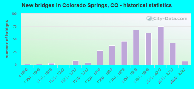
- New bridges - historical statistics
- 1Before 1900
- 11900-1909
- 31910-1919
- 81930-1939
- 41940-1949
- 281950-1959
- 381960-1969
- 461970-1979
- 681980-1989
- 631990-1999
- 752000-2009
- 432010-2019
- 72020-2022
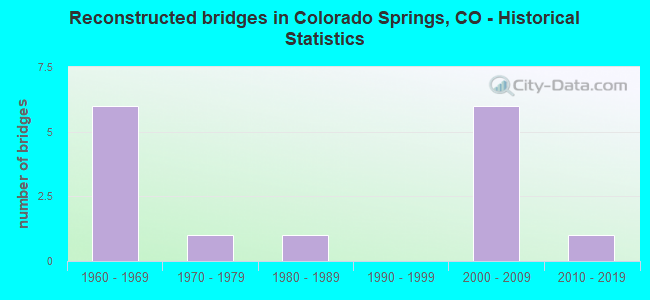
- Reconstructed bridges - Historical Statistics
- 61960-1969
- 11970-1979
- 11980-1989
- 01990-1999
- 62000-2009
- 12010-2019
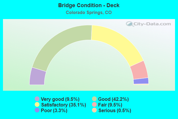
- Bridge Condition - Deck
- 9.5%Very good
- 42.2%Good
- 35.1%Satisfactory
- 9.5%Fair
- 3.3%Poor
- 0.5%Serious
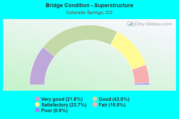
- Bridge Condition - Superstructure
- 21.8%Very good
- 43.6%Good
- 23.7%Satisfactory
- 10.0%Fair
- 0.9%Poor
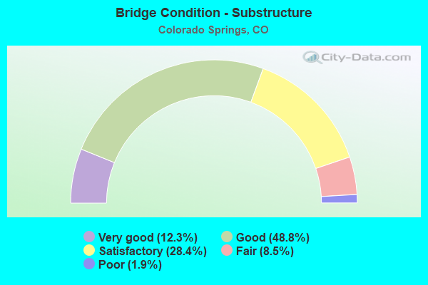
- Bridge Condition - Substructure
- 12.3%Very good
- 48.8%Good
- 28.4%Satisfactory
- 8.5%Fair
- 1.9%Poor
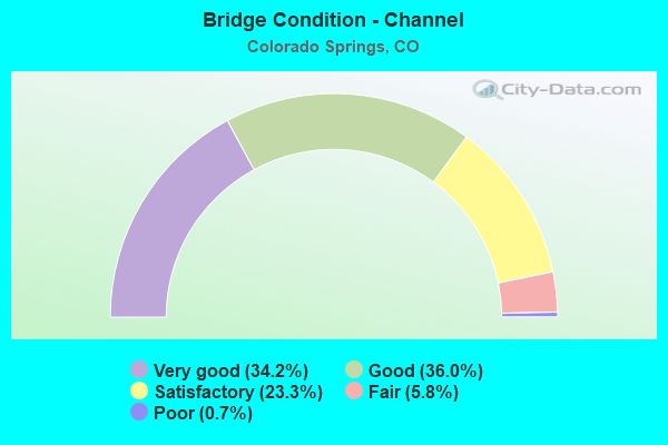
- Bridge Condition - Channel
- 34.2%Very good
- 36.0%Good
- 23.3%Satisfactory
- 5.8%Fair
- 0.7%Poor

- Bridge Condition - Culverts
- 3.5%Very good
- 18.1%Good
- 58.3%Satisfactory
- 16.7%Fair
- 3.5%Poor
Find on map >> Show street view
Structure Number: CSG-K.29-06.66, Location: 0.25 MI E OF ACADEMY BLVD (Lat: 38.804922, Lng: -104.753447), Route carried "on" structure: City street , Year Built: 1982, Status: Open, Structure Length: 6.13m (20.11ft), Average Daily Traffic: 14,363 (year 2021), Truck Traffic: 6%, Average Future Daily Traffic: 18,816 (year 2041), Features Intersected: SAND CREEK, Facility Carried by Structure: CHELTON ROAD
Minimum Vertical Clearance: 30+ m (98+ ft), Kilometerpoint: 2.785, Lanes on structure: 5, Owner: City or Municipal Highway Agency, Approaching Roadway Width: 19.5m (64.0ft), Skew: 4 degrees, Material/Design: Concrete, Design/Construction: Culvert, Number Of Spans In Main Unit: 11, Length of Maximum Span: 5.5m (18.0ft), Curb or Sidewalk Widths: Left: 1.3m (4.3ft), Right: 1.3m (4.3ft), Curb-To-Curb Width: 19.5m (64.0ft), Out-to-Out Width: 23.1m (75.8ft)
Condition: Channel: Good, Culverts: Fair, Operating Rating: 66.5 metric tons, Method Used To Determine Operating Rating: Load Factor (LF), Inventory Rating: 39.8 metric tons, Method Used To Determine Inventory Rating: Load Factor (LF), Structural Evaluation: Somewhat better than minimum adequacy, Deck Geometry: Meets minimum limits, Waterway Adequacy: Equal to present desirable criteria, Approach Roadway Alignment: Equal to present desirable criteria, Designated Inspection Frequency: Every 24 months, Inspection Date: April 2020
Find on map >> Show street view
Structure Number: CSG-K.46-09.92A, Location: .35 S OF PALMER PARK BLVD (Lat: 38.851436, Lng: -104.747883), Route carried "on" structure: City street , Year Built: 1993, Status: Open, Structure Length: 2.02m (6.63ft), Average Daily Traffic: 10,930 (year 2021), Truck Traffic: 4%, Average Future Daily Traffic: 14,318 (year 2041), Design Load: HS 20, Features Intersected: WEST FORK SAND CREEK, Facility Carried by Structure: MURRAY BOULEVARD
Minimum Vertical Clearance: 30+ m (98+ ft), Kilometerpoint: 6.269, Lanes on structure: 4, Owner: City or Municipal Highway Agency, Approaching Roadway Width: 18.9m (62.0ft), Skew: 3 degrees, Material/Design: Prestressed concrete, Design/Construction: Tee Beam, Number Of Spans In Main Unit: 1, Length of Maximum Span: 18.1m (59.4ft), Curb or Sidewalk Widths: Left: 2.1m (6.9ft), Right: 2.7m (8.9ft), Curb-To-Curb Width: 18.9m (62.0ft), Out-to-Out Width: 24.4m (80.1ft)
Condition: Deck: Satisfactory, Superstructure: Satisfactory, Substructure: Good, Channel: Satisfactory, Operating Rating: 41.3 metric tons, Method Used To Determine Operating Rating: Load Factor (LF), Inventory Rating: 24.8 metric tons, Method Used To Determine Inventory Rating: Load Factor (LF), Structural Evaluation: Equal to present minimum criteria, Deck Geometry: Equal to present minimum criteria, Waterway Adequacy: Better than present minimum criteria, Approach Roadway Alignment: Equal to present desirable criteria, Length Of Structure Improvement: 2.02m (6.63ft), Designated Inspection Frequency: Every 24 months, Inspection Date: May 2020, Deck Structure Type: Concrete Cast-file-Place, Wearing Surface/Protective System: Wearing Surface: Bituminous, Membrane: Built-up
Find on map >> Show street view
Structure Number: CSG-K.47-05.33, Location: S. OF DAWNLITE (Lat: 38.785864, Lng: -104.751900), Route carried "on" structure: City street , Year Built: 1982, Status: Open, Structure Length: 0.76m (2.49ft), Average Daily Traffic: 3,721 (year 2021), Truck Traffic: 2%, Average Future Daily Traffic: 4,874 (year 2041), Features Intersected: MAIN STREAM, Facility Carried by Structure: SPRINGNITE DRIVE
Minimum Vertical Clearance: 30+ m (98+ ft), Kilometerpoint: 0.476, Lanes on structure: 2, Owner: City or Municipal Highway Agency, Approaching Roadway Width: 11.0m (36.1ft), Material/Design: Concrete, Design/Construction: Culvert, Number Of Spans In Main Unit: 2, Length of Maximum Span: 3.7m (12.1ft), Curb or Sidewalk Widths: Left: 1.3m (4.3ft), Right: 1.4m (4.6ft), Curb-To-Curb Width: 11.0m (36.1ft), Out-to-Out Width: 14.3m (46.9ft)
Condition: Channel: Satisfactory, Culverts: Fair, Operating Rating: 27.2 metric tons, Method Used To Determine Operating Rating: Field evaluation and documented engineering judgment, Inventory Rating: 16.3 metric tons, Method Used To Determine Inventory Rating: Field evaluation and documented engineering judgment, Structural Evaluation: Meets minimum limits, Deck Geometry: Somewhat better than minimum adequacy, Waterway Adequacy: Equal to present desirable criteria, Approach Roadway Alignment: Equal to present desirable criteria, Designated Inspection Frequency: Every 24 months, Inspection Date: May 2020
Find on map >> Show street view
Structure Number: CSG-K.48-15.25, Location: JUST EAST OF RANGEWOOD DR (Lat: 38.929125, Lng: -104.748958), Route carried "on" structure: City street , Year Built: 1998, Year Reconstructed: 2019, Status: Open, Structure Length: 0.82m (2.69ft), Average Daily Traffic: 13,163 (year 2021), Truck Traffic: 2%, Average Future Daily Traffic: 17,244 (year 2041), Design Load: HS 20+Mod, Features Intersected: COTTONWOOD CREEK TRIB, Facility Carried by Structure: DUBLIN BLVD
Minimum Vertical Clearance: 30+ m (98+ ft), Kilometerpoint: 6.175, Lanes on structure: 5, Owner: City or Municipal Highway Agency, Approaching Roadway Width: 20.1m (65.9ft), Skew: 21 degrees, Material/Design: Steel, Design/Construction: Culvert, Number Of Spans In Main Unit: 2, Length of Maximum Span: 3.5m (11.5ft), Curb or Sidewalk Widths: Left: 1.8m (5.9ft), Right: 1.8m (5.9ft), Out-to-Out Width: 65.8m (215.9ft)
Condition: Channel: Satisfactory, Culverts: Fair, Structural Evaluation: Somewhat better than minimum adequacy, Waterway Adequacy: Equal to present desirable criteria, Approach Roadway Alignment: Equal to present desirable criteria, Designated Inspection Frequency: Every 24 months, Inspection Date: May 2020
Find on map >> Show street view
Structure Number: CSG-K.55-12.58, Location: 0.4 MI N OF N CAREFREE CI (Lat: 38.891572, Lng: -104.747381), Route carried "on" structure: City street , Year Built: 1975, Status: Open, Structure Length: 0.80m (2.62ft), Average Daily Traffic: 1,586 (year 2021), Truck Traffic: 2%, Average Future Daily Traffic: 2,078 (year 2041), Features Intersected: TEMPLETON GAP, Facility Carried by Structure: HOPEFUL DRIVE
Minimum Vertical Clearance: 30+ m (98+ ft), Kilometerpoint: 0.667, Lanes on structure: 2, Owner: City or Municipal Highway Agency, Approaching Roadway Width: 12.2m (40.0ft), Material/Design: Prestressed concrete, Design/Construction: Tee Beam, Number Of Spans In Main Unit: 1, Length of Maximum Span: 7.3m (24.0ft), Curb or Sidewalk Widths: Left: 1.0m (3.3ft), Right: 1.0m (3.3ft), Curb-To-Curb Width: 12.2m (40.0ft), Out-to-Out Width: 14.6m (47.9ft)
Condition: Deck: Satisfactory, Superstructure: Satisfactory, Substructure: Good, Channel: Satisfactory, Operating Rating: 36.3 metric tons, Method Used To Determine Operating Rating: Field evaluation and documented engineering judgment, Inventory Rating: 32.7 metric tons, Method Used To Determine Inventory Rating: Field evaluation and documented engineering judgment, Structural Evaluation: Equal to present minimum criteria, Deck Geometry: Better than present minimum criteria, Waterway Adequacy: Equal to present desirable criteria, Approach Roadway Alignment: Equal to present desirable criteria, Designated Inspection Frequency: Every 48 months, Inspection Date: July 2020, Deck Structure Type: Concrete Cast-file-Place, Wearing Surface/Protective System: Wearing Surface: Bituminous
Find on map >> Show street view
Structure Number: CSG-K.61-09.61, Location: 0.35 MI W OF WOOTEN ROAD (Lat: 38.847119, Lng: -104.743719), Route carried "on" structure: City street , Year Built: 1965, Status: Open, Structure Length: 1.61m (5.28ft), Average Daily Traffic: 15,957 (year 2021), Truck Traffic: 6%, Average Future Daily Traffic: 20,904 (year 2041), Features Intersected: WEST FORK SAND CREEK, Facility Carried by Structure: GALLEY ROAD
Minimum Vertical Clearance: 30+ m (98+ ft), Kilometerpoint: 2.805, Lanes on structure: 4, Owner: City or Municipal Highway Agency, Approaching Roadway Width: 16.5m (54.1ft), Material/Design: Concrete, Design/Construction: Culvert, Number Of Spans In Main Unit: 5, Length of Maximum Span: 3.0m (9.8ft), Curb or Sidewalk Widths: Left: 1.2m (3.9ft), Right: 1.2m (3.9ft), Curb-To-Curb Width: 13.1m (43.0ft), Out-to-Out Width: 15.8m (51.8ft)
Condition: Channel: Fair, Culverts: Fair, Operating Rating: 27.2 metric tons, Method Used To Determine Operating Rating: Field evaluation and documented engineering judgment, Inventory Rating: 16.3 metric tons, Method Used To Determine Inventory Rating: Field evaluation and documented engineering judgment, Structural Evaluation: Meets minimum limits, Deck Geometry: High priority of replacement, Waterway Adequacy: Equal to present desirable criteria, Approach Roadway Alignment: Equal to present minimum criteria, Length Of Structure Improvement: 1.61m (5.28ft), Designated Inspection Frequency: Every 24 months, Inspection Date: May 2020, Bridge Improvement Cost: $197,000, Roadway Improvement Cost: $20,000, Total Project Cost: $217,000 ( Estimate for 2014), Deck Structure Type: Concrete Cast-file-Place, Wearing Surface/Protective System: Wearing Surface: Bituminous
Find on map >> Show street view
Structure Number: CSG-K.72-09., Location: 0.75 MI E OF ACADEMY BLVD (Lat: 38.839586, Lng: -104.742053), Route carried "on" structure: City street , Year Built: 1969, Status: Open, Structure Length: 1.57m (5.15ft), Average Daily Traffic: 38,255 (year 2021), Truck Traffic: 6%, Average Future Daily Traffic: 50,114 (year 2041), Design Load: HS 20, Features Intersected: WEST FORK SAND CREEK, Facility Carried by Structure: PLATTE AVENUE
Minimum Vertical Clearance: 30+ m (98+ ft), Kilometerpoint: 7.332, Lanes on structure: 6, Owner: City or Municipal Highway Agency, Approaching Roadway Width: 33.9m (111.2ft), Skew: 20 degrees, Material/Design: Concrete, Design/Construction: Culvert, Number Of Spans In Main Unit: 3, Length of Maximum Span: 5.7m (18.7ft), Curb-To-Curb Width: 33.9m (111.2ft), Out-to-Out Width: 66.4m (217.8ft)
Condition: Channel: Very good, Culverts: Satisfactory, Operating Rating: 36.3 metric tons, Method Used To Determine Operating Rating: Field evaluation and documented engineering judgment, Inventory Rating: 32.7 metric tons, Method Used To Determine Inventory Rating: Field evaluation and documented engineering judgment, Structural Evaluation: Equal to present minimum criteria, Deck Geometry: Superior to present desirable criteria, Waterway Adequacy: Equal to present desirable criteria, Approach Roadway Alignment: Equal to present desirable criteria, Length Of Structure Improvement: 1.57m (5.15ft), Designated Inspection Frequency: Every 24 months, Inspection Date: May 2020
Find on map >> Show street view
Structure Number: CSG-K.73-05.38, Location: 0.15 MI S OF HANCOCK (Lat: 38.786597, Lng: -104.747050), Route carried "on" structure: City street , Year Built: 1982, Status: Open, Structure Length: 0.76m (2.49ft), Average Daily Traffic: 2,018 (year 2021), Truck Traffic: 2%, Average Future Daily Traffic: 2,644 (year 2041), Features Intersected: MAIN STREAM, Facility Carried by Structure: MONICA DRIVE
Minimum Vertical Clearance: 30+ m (98+ ft), Kilometerpoint: 0.522, Lanes on structure: 2, Owner: City or Municipal Highway Agency, Approaching Roadway Width: 10.4m (34.1ft), Material/Design: Concrete, Design/Construction: Culvert, Number Of Spans In Main Unit: 2, Length of Maximum Span: 3.7m (12.1ft), Curb or Sidewalk Widths: Left: 1.4m (4.6ft), Right: 1.4m (4.6ft), Curb-To-Curb Width: 10.4m (34.1ft), Out-to-Out Width: 13.7m (44.9ft)
Condition: Channel: Good, Culverts: Satisfactory, Operating Rating: 36.3 metric tons, Method Used To Determine Operating Rating: Field evaluation and documented engineering judgment, Inventory Rating: 32.7 metric tons, Method Used To Determine Inventory Rating: Field evaluation and documented engineering judgment, Structural Evaluation: Equal to present minimum criteria, Deck Geometry: Somewhat better than minimum adequacy, Waterway Adequacy: Equal to present desirable criteria, Approach Roadway Alignment: Equal to present desirable criteria, Designated Inspection Frequency: Every 24 months, Inspection Date: May 2020
Find on map >> Show street view
Structure Number: CSG-K.78-08.1, Location: 0.8 MI E OF ACADEMY BLVD. (Lat: 38.825256, Lng: -104.742122), Route carried "on" structure: City street , Year Built: 1975, Status: Open, Structure Length: 5.03m (16.50ft), Average Daily Traffic: 16,988 (year 2021), Truck Traffic: 6%, Average Future Daily Traffic: 22,254 (year 2041), Features Intersected: SAND CREEK, Facility Carried by Structure: AIRPORT ROAD
Minimum Vertical Clearance: 30+ m (98+ ft), Kilometerpoint: 4.529, Lanes on structure: 4, Owner: City or Municipal Highway Agency, Approaching Roadway Width: 21.9m (71.9ft), Skew: 22 degrees, Material/Design: Prestressed concrete continuous, Design/Construction: Stringer/Multi-beam, Number Of Spans In Main Unit: 2, Length of Maximum Span: 23.9m (78.4ft), Curb or Sidewalk Widths: Left: 1.5m (4.9ft), Right: 1.5m (4.9ft), Curb-To-Curb Width: 23.8m (78.1ft), Out-to-Out Width: 27.6m (90.6ft)
Condition: Deck: Good, Superstructure: Good, Substructure: Satisfactory, Channel: Satisfactory, Operating Rating: 38.3 metric tons, Method Used To Determine Operating Rating: Load Factor (LF), Inventory Rating: 23.0 metric tons, Method Used To Determine Inventory Rating: Load Factor (LF), Structural Evaluation: Somewhat better than minimum adequacy, Deck Geometry: Superior to present desirable criteria, Waterway Adequacy: Equal to present desirable criteria, Approach Roadway Alignment: Equal to present desirable criteria, Designated Inspection Frequency: Every 24 months, Inspection Date: May 2020, Deck Structure Type: Concrete Cast-file-Place, Wearing Surface/Protective System: Wearing Surface: Bituminous, Membrane: Built-up
Find on map >> Show street view
Structure Number: CSG-K.82-15.2, Location: 0.3 MI S OF DUBLIN BLVD (Lat: 38.929164, Lng: -104.740542), Route carried "on" structure: City street , Year Built: 1998, Status: Open, Structure Length: 0.89m (2.92ft), Average Daily Traffic: 24,097 (year 2021), Average Future Daily Traffic: 31,567 (year 2041), Design Load: HS 20, Features Intersected: COTTONWOOD CREEK TRIB, Facility Carried by Structure: AUSTIN BLUFFS PKWY
Minimum Vertical Clearance: 30+ m (98+ ft), Kilometerpoint: 11.073, Lanes on structure: 4, Owner: City or Municipal Highway Agency, Approaching Roadway Width: 21.9m (71.9ft), Skew: 33 degrees, Material/Design: Steel, Design/Construction: Culvert, Number Of Spans In Main Unit: 2, Length of Maximum Span: 3.7m (12.1ft), Curb or Sidewalk Widths: Left: 3.0m (9.8ft), Right: 3.0m (9.8ft), Out-to-Out Width: 78.6m (257.9ft)
Condition: Channel: Satisfactory, Culverts: Satisfactory, Structural Evaluation: Equal to present minimum criteria, Waterway Adequacy: Equal to present desirable criteria, Approach Roadway Alignment: Equal to present desirable criteria, Length Of Structure Improvement: 0.89m (2.92ft), Designated Inspection Frequency: Every 24 months, Inspection Date: May 2020
Find on map >> Show street view
Structure Number: CSG-K.87-16.00A, Location: W OF AUSTIN BLUFFS PKWY (Lat: 38.939986, Lng: -104.740919), Route carried "on" structure: City street , Year Built: 2000, Status: Open, Structure Length: 4.42m (14.50ft), Average Daily Traffic: 36,527 (year 2021), Truck Traffic: 5%, Average Future Daily Traffic: 47,850 (year 2041), Design Load: HS 25 or greater, Features Intersected: COTTONWOOD CREEK, Facility Carried by Structure: WOODMEN ROAD
Minimum Vertical Clearance: 30+ m (98+ ft), Kilometerpoint: 16.259, Lanes on structure: 9, Base Highway Network: Yes, Owner: City or Municipal Highway Agency, Approaching Roadway Width: 36.7m (120.4ft), Skew: 23 degrees, Material/Design: Prestressed concrete, Design/Construction: Stringer/Multi-beam, Number Of Spans In Main Unit: 1, Length of Maximum Span: 42.2m (138.5ft), Curb or Sidewalk Widths: Left: 3.0m (9.8ft), Right: 1.8m (5.9ft), Curb-To-Curb Width: 36.7m (120.4ft), Out-to-Out Width: 44.5m (146.0ft)
Condition: Deck: Good, Superstructure: Very good, Substructure: Satisfactory, Channel: Satisfactory, Operating Rating: 84.5 metric tons, Method Used To Determine Operating Rating: Load Factor (LF), Inventory Rating: 47.4 metric tons, Method Used To Determine Inventory Rating: Load Factor (LF), Structural Evaluation: Equal to present minimum criteria, Deck Geometry: Somewhat better than minimum adequacy, Waterway Adequacy: Equal to present desirable criteria, Approach Roadway Alignment: Equal to present desirable criteria, Length Of Structure Improvement: 4.42m (14.50ft), Designated Inspection Frequency: Every 24 months, Inspection Date: May 2020, Deck Structure Type: Concrete Cast-file-Place, Wearing Surface/Protective System: Wearing Surface: Bituminous, Membrane: Built-up, Deck Protection: Epoxy Coated Reinforcing
Find on map >> Show street view
Structure Number: CSG-K.90-16.1, Location: JUST NORTH OF WOODMEN RD. (Lat: 38.941011, Lng: -104.739361), Route carried "on" structure: City street , Year Built: 1998, Status: Open, Structure Length: 4.23m (13.88ft), Average Daily Traffic: 15,210 (year 2021), Truck Traffic: 2%, Average Future Daily Traffic: 19,925 (year 2041), Design Load: HS 20, Features Intersected: COTTONWOOD CREEK, Facility Carried by Structure: AUSTIN BLUFFS PKWY
Minimum Vertical Clearance: 30+ m (98+ ft), Kilometerpoint: 12.463, Lanes on structure: 3, Owner: City or Municipal Highway Agency, Approaching Roadway Width: 12.2m (40.0ft), Material/Design: Prestressed concrete, Design/Construction: Stringer/Multi-beam, Number Of Spans In Main Unit: 1, Length of Maximum Span: 40.6m (133.2ft), Curb or Sidewalk Widths: Left: 0.0m, Right: 1.8m (5.9ft), Curb-To-Curb Width: 12.2m (40.0ft), Out-to-Out Width: 14.9m (48.9ft)
Condition: Deck: Good, Superstructure: Very good, Substructure: Good, Channel: Very good, Operating Rating: 85.5 metric tons, Method Used To Determine Operating Rating: Load Factor (LF), Inventory Rating: 39.9 metric tons, Method Used To Determine Inventory Rating: Load Factor (LF), Structural Evaluation: Better than present minimum criteria, Deck Geometry: Meets minimum limits, Waterway Adequacy: Equal to present desirable criteria, Approach Roadway Alignment: Better than present minimum criteria, Length Of Structure Improvement: 4.23m (13.88ft), Designated Inspection Frequency: Every 24 months, Inspection Date: May 2020, Deck Structure Type: Concrete Cast-file-Place, Wearing Surface/Protective System: Wearing Surface: Bituminous, Deck Protection: Epoxy Coated Reinforcing
Find on map >> Show street view
Structure Number: CSG-K.98-13.15, Location: 0.15 MI N OF BARNES RD (Lat: 38.898764, Lng: -104.738561), Route carried "on" structure: City street , Year Built: 1980, Status: Open, Structure Length: 0.61m (2.00ft), Average Daily Traffic: 6,262 (year 2021), Truck Traffic: 4%, Average Future Daily Traffic: 8,203 (year 2041), Features Intersected: TEMPLETON GAP FLOODWAY, Facility Carried by Structure: ORO BLANCO DR
Minimum Vertical Clearance: 30+ m (98+ ft), Kilometerpoint: 3.646, Lanes on structure: 3, Owner: City or Municipal Highway Agency, Approaching Roadway Width: 18.3m (60.0ft), Skew: 2 degrees, Material/Design: Concrete, Design/Construction: Culvert, Number Of Spans In Main Unit: 2, Length of Maximum Span: 2.9m (9.5ft), Curb or Sidewalk Widths: Left: 1.2m (3.9ft), Right: 1.2m (3.9ft), Curb-To-Curb Width: 18.3m (60.0ft), Out-to-Out Width: 28.5m (93.5ft)
Condition: Channel: Very good, Culverts: Satisfactory, Operating Rating: 36.3 metric tons, Method Used To Determine Operating Rating: Field evaluation and documented engineering judgment, Inventory Rating: 32.7 metric tons, Method Used To Determine Inventory Rating: Field evaluation and documented engineering judgment, Structural Evaluation: Equal to present minimum criteria, Deck Geometry: Superior to present desirable criteria, Waterway Adequacy: Equal to present desirable criteria, Approach Roadway Alignment: Equal to present desirable criteria, Designated Inspection Frequency: Every 24 months, Inspection Date: April 2020
Find on map >> Show street view
Structure Number: CSG-L.00-15.6, Location: JUST WEST OF CHANNEL DRIV (Lat: 38.953103, Lng: -104.728600), Route carried "on" structure: City street , Year Built: 1994, Status: Open, Structure Length: 0.63m (2.07ft), Average Daily Traffic: 1,533 (year 2021), Average Future Daily Traffic: 2,008 (year 2041), Features Intersected: FAIRFAX CHANNEL, Facility Carried by Structure: CHANCELLOR DR
Minimum Vertical Clearance: 30+ m (98+ ft), Kilometerpoint: 2.528, Lanes on structure: 2, Owner: City or Municipal Highway Agency, Approaching Roadway Width: 11.0m (36.1ft), Material/Design: Concrete, Design/Construction: Culvert, Number Of Spans In Main Unit: 2, Length of Maximum Span: 3.0m (9.8ft), Curb or Sidewalk Widths: Left: 1.7m (5.6ft), Right: 1.7m (5.6ft), Out-to-Out Width: 25.0m (82.0ft)
Condition: Channel: Good, Culverts: Satisfactory, Operating Rating: 36.3 metric tons, Method Used To Determine Operating Rating: Load Factor (LF), Inventory Rating: 32.7 metric tons, Method Used To Determine Inventory Rating: Load Factor (LF), Structural Evaluation: Equal to present minimum criteria, Waterway Adequacy: Equal to present desirable criteria, Approach Roadway Alignment: Equal to present desirable criteria, Designated Inspection Frequency: Every 24 months, Inspection Date: April 2020
Find on map >> Show street view
Structure Number: CSG-L.05-09.61, Location: INTER- GALLEY WOOTEN (Lat: 38.847111, Lng: -104.738808), Route carried "on" structure: City street , Year Built: 1970, Status: Open, Structure Length: 1.02m (3.35ft), Average Daily Traffic: 16,074 (year 2021), Truck Traffic: 6%, Average Future Daily Traffic: 21,057 (year 2041), Features Intersected: WEST FORK SAND CREEK, Facility Carried by Structure: GALLEY ROAD
Minimum Vertical Clearance: 30+ m (98+ ft), Kilometerpoint: 3.244, Lanes on structure: 5, Owner: City or Municipal Highway Agency, Approaching Roadway Width: 17.1m (56.1ft), Skew: 3 degrees, Material/Design: Concrete, Design/Construction: Culvert, Number Of Spans In Main Unit: 3, Length of Maximum Span: 3.2m (10.5ft), Curb or Sidewalk Widths: Left: 1.2m (3.9ft), Right: 1.3m (4.3ft), Curb-To-Curb Width: 30.7m (100.7ft), Out-to-Out Width: 31.0m (101.7ft)
Condition: Channel: Good, Culverts: Satisfactory, Operating Rating: 36.3 metric tons, Method Used To Determine Operating Rating: Field evaluation and documented engineering judgment, Inventory Rating: 32.7 metric tons, Method Used To Determine Inventory Rating: Field evaluation and documented engineering judgment, Structural Evaluation: Equal to present minimum criteria, Deck Geometry: Superior to present desirable criteria, Waterway Adequacy: Equal to present desirable criteria, Approach Roadway Alignment: Equal to present desirable criteria, Designated Inspection Frequency: Every 24 months, Inspection Date: May 2020, Deck Structure Type: Concrete Cast-file-Place, Wearing Surface/Protective System: Wearing Surface: Bituminous
Find on map >> Show street view
Structure Number: CSG-L.08-10.08, Location: 0.8 MI E OF MURRAY BLVD. (Lat: 38.854178, Lng: -104.736628), Route carried "on" structure: City street , Year Built: 1972, Status: Open, Structure Length: 0.62m (2.03ft), Average Daily Traffic: 12,065 (year 2021), Truck Traffic: 6%, Average Future Daily Traffic: 15,805 (year 2041), Features Intersected: WEST FORK SAND CREEK, Facility Carried by Structure: PALMER PARK BLVD
Minimum Vertical Clearance: 30+ m (98+ ft), Kilometerpoint: 6.157, Lanes on structure: 4, Owner: City or Municipal Highway Agency, Approaching Roadway Width: 18.3m (60.0ft), Skew: 2 degrees, Material/Design: Concrete, Design/Construction: Culvert, Number Of Spans In Main Unit: 2, Length of Maximum Span: 3.0m (9.8ft), Curb or Sidewalk Widths: Left: 1.1m (3.6ft), Right: 1.1m (3.6ft), Curb-To-Curb Width: 18.3m (60.0ft), Out-to-Out Width: 21.0m (68.9ft)
Condition: Channel: Satisfactory, Culverts: Satisfactory, Operating Rating: 36.3 metric tons, Method Used To Determine Operating Rating: Field evaluation and documented engineering judgment, Inventory Rating: 32.7 metric tons, Method Used To Determine Inventory Rating: Field evaluation and documented engineering judgment, Structural Evaluation: Equal to present minimum criteria, Deck Geometry: Somewhat better than minimum adequacy, Waterway Adequacy: Equal to present desirable criteria, Approach Roadway Alignment: Equal to present desirable criteria, Designated Inspection Frequency: Every 24 months, Inspection Date: April 2020
Find on map >> Show street view
Structure Number: CSG-L.20-14.87, Location: JUST WEST OF CORINTH DR. (Lat: 38.923989, Lng: -104.733583), Route carried "on" structure: City street , Year Built: 1998, Status: Open, Structure Length: 1.25m (4.10ft), Average Daily Traffic: 1,634 (year 2021), Truck Traffic: 2%, Average Future Daily Traffic: 2,141 (year 2041), Design Load: HS 20, Features Intersected: COTTONWOOD CREEK TRIB, Facility Carried by Structure: BALSAM STREET
Minimum Vertical Clearance: 30+ m (98+ ft), Kilometerpoint: 0.251, Lanes on structure: 2, Owner: City or Municipal Highway Agency, Approaching Roadway Width: 11.0m (36.1ft), Skew: 2 degrees, Material/Design: Concrete, Design/Construction: Culvert, Number Of Spans In Main Unit: 3, Length of Maximum Span: 4.0m (13.1ft), Curb or Sidewalk Widths: Left: 1.2m (3.9ft), Right: 1.5m (4.9ft), Out-to-Out Width: 28.1m (92.2ft)
Condition: Channel: Satisfactory, Culverts: Satisfactory, Operating Rating: 76.6 metric tons, Method Used To Determine Operating Rating: Load Factor (LF), Inventory Rating: 45.9 metric tons, Method Used To Determine Inventory Rating: Load Factor (LF), Structural Evaluation: Equal to present minimum criteria, Waterway Adequacy: Equal to present desirable criteria, Approach Roadway Alignment: Equal to present desirable criteria, Length Of Structure Improvement: 1.25m (4.10ft), Designated Inspection Frequency: Every 24 months, Inspection Date: May 2020
Find on map >> Show street view
Structure Number: CSG-L.45-17., Location: JUST W OF CHANNEL DRIVE (Lat: 38.954639, Lng: -104.729769), Route carried "on" structure: City street , Year Built: 1997, Status: Open, Structure Length: 0.63m (2.07ft), Average Daily Traffic: 13,113 (year 2021), Truck Traffic: 2%, Average Future Daily Traffic: 17,178 (year 2041), Features Intersected: FAIRFAX CHANNEL, Facility Carried by Structure: RESEARCH PARKWAY
Minimum Vertical Clearance: 30+ m (98+ ft), Kilometerpoint: 6.186, Lanes on structure: 5, Owner: City or Municipal Highway Agency, Approaching Roadway Width: 27.1m (88.9ft), Skew: 30 degrees, Material/Design: Concrete, Design/Construction: Culvert, Number Of Spans In Main Unit: 2, Length of Maximum Span: 3.0m (9.8ft), Out-to-Out Width: 75.2m (246.7ft)
Condition: Channel: Very good, Culverts: Fair, Operating Rating: 36.3 metric tons, Method Used To Determine Operating Rating: Field evaluation and documented engineering judgment, Inventory Rating: 32.7 metric tons, Method Used To Determine Inventory Rating: Field evaluation and documented engineering judgment, Structural Evaluation: Somewhat better than minimum adequacy, Waterway Adequacy: Equal to present desirable criteria, Approach Roadway Alignment: Equal to present desirable criteria, Length Of Structure Improvement: 0.63m (2.07ft), Designated Inspection Frequency: Every 24 months, Inspection Date: May 2020
Find on map >> Show street view
Structure Number: CSG-L.53-08.88, Location: 0.3 MI S OF PLATTE AVE (Lat: 38.836514, Lng: -104.738781), Route carried "on" structure: City street , Year Built: 1984, Status: Open, Structure Length: 1.14m (3.74ft), Average Daily Traffic: 794 (year 2021), Average Future Daily Traffic: 1,041 (year 2041), Features Intersected: WEST FORK SAND CREEK, Facility Carried by Structure: WOOTEN ROAD
Minimum Vertical Clearance: 30+ m (98+ ft), Kilometerpoint: 0.084, Lanes on structure: 2, Owner: City or Municipal Highway Agency, Approaching Roadway Width: 18.3m (60.0ft), Material/Design: Concrete, Design/Construction: Culvert, Number Of Spans In Main Unit: 3, Length of Maximum Span: 4.3m (14.1ft), Curb-To-Curb Width: 18.4m (60.4ft), Out-to-Out Width: 26.2m (86.0ft)
Condition: Channel: Good, Culverts: Satisfactory, Operating Rating: 36.3 metric tons, Method Used To Determine Operating Rating: Field evaluation and documented engineering judgment, Inventory Rating: 32.7 metric tons, Method Used To Determine Inventory Rating: Field evaluation and documented engineering judgment, Structural Evaluation: Equal to present minimum criteria, Deck Geometry: Superior to present desirable criteria, Waterway Adequacy: Equal to present desirable criteria, Approach Roadway Alignment: Equal to present desirable criteria, Designated Inspection Frequency: Every 24 months, Inspection Date: May 2020
Find on map >> Show street view
Structure Number: CSG-L.56-08.97, Location: 0.3 MI W OF POWERS BLVD (Lat: 38.839194, Lng: -104.729136), Route carried "on" structure: City street , Year Built: 1956, Year Reconstructed: 1968, Status: Open, Structure Length: 10.87m (35.66ft), Average Daily Traffic: 19,495 (year 2021), Truck Traffic: 6%, Average Future Daily Traffic: 25,538 (year 2041), Design Load: HS 20, Features Intersected: SAND CREEK, Facility Carried by Structure: EB PLATTE AVE
Minimum Vertical Clearance: 30+ m (98+ ft), Kilometerpoint: 8.467, Lanes on structure: 2, Owner: City or Municipal Highway Agency, Approaching Roadway Width: 11.6m (38.1ft), Material/Design: Concrete, Design/Construction: Tee Beam, Number Of Spans In Main Unit: 7, Length of Maximum Span: 14.6m (47.9ft), Curb or Sidewalk Widths: Left: 0.6m (2.0ft), Right: 0.6m (2.0ft), Curb-To-Curb Width: 9.1m (29.9ft), Out-to-Out Width: 10.4m (34.1ft)
Condition: Deck: Satisfactory, Superstructure: Fair, Substructure: Fair, Channel: Satisfactory, Operating Rating: 46.1 metric tons, Method Used To Determine Operating Rating: Load Factor (LF), Inventory Rating: 27.9 metric tons, Method Used To Determine Inventory Rating: Load Factor (LF), Structural Evaluation: Somewhat better than minimum adequacy, Deck Geometry: Meets minimum limits, Waterway Adequacy: Equal to present desirable criteria, Approach Roadway Alignment: Equal to present desirable criteria, Designated Inspection Frequency: Every 24 months, Inspection Date: May 2020, Deck Structure Type: Concrete Cast-file-Place, Wearing Surface/Protective System: Wearing Surface: Bituminous
Find on map >> Show street view
Structure Number: CSG-L.57-08.99, Location: 0.3 MI W OF POWERS BLVD (Lat: 38.839353, Lng: -104.729117), Route carried "on" structure: City street , Year Built: 1956, Year Reconstructed: 1968, Status: Open, Structure Length: 10.87m (35.66ft), Average Daily Traffic: 20,975 (year 2021), Truck Traffic: 6%, Average Future Daily Traffic: 27,477 (year 2041), Design Load: HS 20, Features Intersected: SAND CREEK, Facility Carried by Structure: WB PLATTE AVE
Minimum Vertical Clearance: 30+ m (98+ ft), Kilometerpoint: 8.467, Lanes on structure: 2, Owner: City or Municipal Highway Agency, Approaching Roadway Width: 11.6m (38.1ft), Material/Design: Concrete, Design/Construction: Tee Beam, Number Of Spans In Main Unit: 7, Length of Maximum Span: 14.6m (47.9ft), Curb or Sidewalk Widths: Left: 0.6m (2.0ft), Right: 0.6m (2.0ft), Curb-To-Curb Width: 9.1m (29.9ft), Out-to-Out Width: 10.4m (34.1ft)
Condition: Deck: Fair, Superstructure: Fair, Substructure: Satisfactory, Channel: Satisfactory, Operating Rating: 46.1 metric tons, Method Used To Determine Operating Rating: Load Factor (LF), Inventory Rating: 27.9 metric tons, Method Used To Determine Inventory Rating: Load Factor (LF), Structural Evaluation: Somewhat better than minimum adequacy, Deck Geometry: Meets minimum limits, Waterway Adequacy: Equal to present desirable criteria, Approach Roadway Alignment: Equal to present desirable criteria, Designated Inspection Frequency: Every 24 months, Inspection Date: May 2020, Deck Structure Type: Concrete Cast-file-Place, Wearing Surface/Protective System: Wearing Surface: Bituminous
Find on map >> Show street view
Structure Number: CSG-L.59-08.08, Location: 0.4 MI W OF POWERS BLVD. (Lat: 38.824811, Lng: -104.729483), Route carried "on" structure: City street , Year Built: 1979, Status: Open, Structure Length: 1.28m (4.20ft), Average Daily Traffic: 13,681 (year 2021), Truck Traffic: 6%, Average Future Daily Traffic: 17,922 (year 2041), Features Intersected: WEST FORK SAND CREEK, Facility Carried by Structure: AIRPORT ROAD
Minimum Vertical Clearance: 30+ m (98+ ft), Kilometerpoint: 5.673, Lanes on structure: 5, Owner: City or Municipal Highway Agency, Approaching Roadway Width: 20.1m (65.9ft), Skew: 20 degrees, Material/Design: Concrete, Design/Construction: Culvert, Number Of Spans In Main Unit: 5, Length of Maximum Span: 2.4m (7.9ft), Curb or Sidewalk Widths: Left: 1.2m (3.9ft), Right: 1.2m (3.9ft), Curb-To-Curb Width: 20.1m (65.9ft), Out-to-Out Width: 26.2m (86.0ft)
Condition: Channel: Good, Culverts: Satisfactory, Operating Rating: 36.3 metric tons, Method Used To Determine Operating Rating: Load Factor (LF), Inventory Rating: 21.7 metric tons, Method Used To Determine Inventory Rating: Load Factor (LF), Structural Evaluation: Somewhat better than minimum adequacy, Deck Geometry: Somewhat better than minimum adequacy, Waterway Adequacy: Better than present minimum criteria, Approach Roadway Alignment: Equal to present desirable criteria, Designated Inspection Frequency: Every 24 months, Inspection Date: May 2020, Deck Structure Type: Concrete Cast-file-Place, Wearing Surface/Protective System: Wearing Surface: Bituminous
Find on map >> Show street view
Structure Number: CSG-L.60-14.93, Location: 0.3 MI S OF DUBLIN BLVD (Lat: 38.925853, Lng: -104.727253), Route carried "on" structure: City street , Year Built: 1995, Status: Open, Structure Length: 0.64m (2.10ft), Average Daily Traffic: 1,721 (year 2021), Truck Traffic: 2%, Average Future Daily Traffic: 2,254 (year 2041), Features Intersected: COTTONWOOD CREEK TRIB, Facility Carried by Structure: OAKWOOD BLVD
Minimum Vertical Clearance: 30+ m (98+ ft), Kilometerpoint: 0.843, Lanes on structure: 2, Owner: City or Municipal Highway Agency, Approaching Roadway Width: 11.0m (36.1ft), Skew: 3 degrees, Material/Design: Concrete, Design/Construction: Culvert, Number Of Spans In Main Unit: 2, Length of Maximum Span: 2.7m (8.9ft), Curb or Sidewalk Widths: Left: 1.2m (3.9ft), Right: 1.2m (3.9ft), Out-to-Out Width: 33.9m (111.2ft)
Condition: Channel: Good, Culverts: Satisfactory, Operating Rating: 36.3 metric tons, Method Used To Determine Operating Rating: Field evaluation and documented engineering judgment, Inventory Rating: 32.7 metric tons, Method Used To Determine Inventory Rating: Field evaluation and documented engineering judgment, Structural Evaluation: Equal to present minimum criteria, Waterway Adequacy: Better than present minimum criteria, Approach Roadway Alignment: Equal to present desirable criteria, Length Of Structure Improvement: 0.64m (2.10ft), Designated Inspection Frequency: Every 24 months, Inspection Date: May 2020
Find on map >> Show street view
Structure Number: CSG-L.65-08.4, Location: 0.4 MI N OF AIRPORT RD (Lat: 38.829489, Lng: -104.724919), Route carried "on" structure: City street , Year Built: 2000, Status: Open, Structure Length: 1.54m (5.05ft), Average Daily Traffic: 2,025 (year 2021), Truck Traffic: 4%, Average Future Daily Traffic: 2,653 (year 2041), Design Load: HS 20, Features Intersected: W. FORK SAND CREEK, Facility Carried by Structure: TROY HILL RD
Minimum Vertical Clearance: 30+ m (98+ ft), Kilometerpoint: 0.602, Lanes on structure: 2, Owner: City or Municipal Highway Agency, Approaching Roadway Width: 8.4m (27.6ft), Skew: 1 degrees, Material/Design: Concrete, Design/Construction: Culvert, Number Of Spans In Main Unit: 3, Length of Maximum Span: 4.9m (16.1ft), Out-to-Out Width: 26.0m (85.3ft)
Condition: Channel: Good, Culverts: Satisfactory, Operating Rating: 36.3 metric tons, Method Used To Determine Operating Rating: Field evaluation and documented engineering judgment, Inventory Rating: 32.7 metric tons, Method Used To Determine Inventory Rating: Field evaluation and documented engineering judgment, Structural Evaluation: Equal to present minimum criteria, Waterway Adequacy: Equal to present desirable criteria, Approach Roadway Alignment: Equal to present desirable criteria, Length Of Structure Improvement: 1.54m (5.05ft), Designated Inspection Frequency: Every 24 months, Inspection Date: May 2020
Find on map >> Show street view
Structure Number: CSG-L.80-05.7, Location: 0.1 MI S OF AVIATION WAY (Lat: 38.792036, Lng: -104.725372), Route carried "on" structure: City street , Year Built: 1986, Status: Open, Structure Length: 0.63m (2.07ft), Average Daily Traffic: 2,018 (year 2021), Truck Traffic: 2%, Average Future Daily Traffic: 2,644 (year 2041), Features Intersected: DRAINAGE CANAL, Facility Carried by Structure: ZEPPELIN ROAD
Minimum Vertical Clearance: 30+ m (98+ ft), Kilometerpoint: 0.520, Lanes on structure: 2, Owner: City or Municipal Highway Agency, Approaching Roadway Width: 13.4m (44.0ft), Skew: 2 degrees, Material/Design: Concrete, Design/Construction: Culvert, Number Of Spans In Main Unit: 2, Length of Maximum Span: 3.0m (9.8ft), Out-to-Out Width: 41.4m (135.8ft)
Condition: Channel: Good, Culverts: Satisfactory, Operating Rating: 64.4 metric tons, Method Used To Determine Operating Rating: Load Factor (LF), Inventory Rating: 38.6 metric tons, Method Used To Determine Inventory Rating: Load Factor (LF), Structural Evaluation: Equal to present minimum criteria, Waterway Adequacy: Equal to present desirable criteria, Approach Roadway Alignment: Equal to present desirable criteria, Designated Inspection Frequency: Every 24 months, Inspection Date: July 2020
Find on map >> Show street view
Structure Number: CSG-L.80-09.61, Location: 0.25 MI W OF POWERS BLVD. (Lat: 38.846400, Lng: -104.724925), Route carried "on" structure: City street , Year Built: 1993, Status: Open, Structure Length: 4.76m (15.62ft), Average Daily Traffic: 16,074 (year 2021), Truck Traffic: 2%, Average Future Daily Traffic: 21,057 (year 2041), Design Load: HS 20, Features Intersected: SAND CREEK, Facility Carried by Structure: GALLEY ROAD
Minimum Vertical Clearance: 30+ m (98+ ft), Kilometerpoint: 4.485, Lanes on structure: 3, Owner: City or Municipal Highway Agency, Approaching Roadway Width: 19.5m (64.0ft), Skew: 6 degrees, Material/Design: Prestressed concrete continuous, Design/Construction: Box Beam or Girders - Single/Spread, Number Of Spans In Main Unit: 2, Length of Maximum Span: 23.3m (76.4ft), Curb or Sidewalk Widths: Left: 2.0m (6.6ft), Right: 2.0m (6.6ft), Curb-To-Curb Width: 19.5m (64.0ft), Out-to-Out Width: 24.5m (80.4ft)
Condition: Deck: Good, Superstructure: Satisfactory, Substructure: Satisfactory, Channel: Very good, Operating Rating: 60.1 metric tons, Method Used To Determine Operating Rating: Load Factor (LF), Inventory Rating: 36.1 metric tons, Method Used To Determine Inventory Rating: Load Factor (LF), Structural Evaluation: Equal to present minimum criteria, Deck Geometry: Superior to present desirable criteria, Waterway Adequacy: Equal to present desirable criteria, Approach Roadway Alignment: Equal to present desirable criteria, Designated Inspection Frequency: Every 24 months, Inspection Date: May 2020, Deck Structure Type: Concrete Cast-file-Place, Wearing Surface/Protective System: Wearing Surface: Bituminous, Membrane: Built-up
Find on map >> Show street view
Structure Number: CSG-L.80-10.31, Location: 0.2 MI W OF POWERS BLVD. (Lat: 38.857089, Lng: -104.724428), Route carried "on" structure: City street , Year Built: 1970, Status: Open, Structure Length: 4.59m (15.06ft), Average Daily Traffic: 13,644 (year 2021), Truck Traffic: 6%, Average Future Daily Traffic: 17,874 (year 2041), Features Intersected: SAND CREEK, Facility Carried by Structure: PALMER PARK BLVD
Minimum Vertical Clearance: 30+ m (98+ ft), Kilometerpoint: 7.308, Lanes on structure: 4, Owner: City or Municipal Highway Agency, Approaching Roadway Width: 18.3m (60.0ft), Skew: 2 degrees, Material/Design: Prestressed concrete, Design/Construction: Tee Beam, Number Of Spans In Main Unit: 4, Length of Maximum Span: 10.5m (34.4ft), Curb or Sidewalk Widths: Left: 1.2m (3.9ft), Right: 1.2m (3.9ft), Curb-To-Curb Width: 18.3m (60.0ft), Out-to-Out Width: 20.7m (67.9ft)
Condition: Deck: Fair, Superstructure: Fair, Substructure: Satisfactory, Channel: Satisfactory, Operating Rating: 32.7 metric tons, Method Used To Determine Operating Rating: Field evaluation and documented engineering judgment, Inventory Rating: 24.5 metric tons, Method Used To Determine Inventory Rating: Field evaluation and documented engineering judgment, Structural Evaluation: Somewhat better than minimum adequacy, Deck Geometry: Somewhat better than minimum adequacy, Waterway Adequacy: Equal to present desirable criteria, Approach Roadway Alignment: Equal to present desirable criteria, Length Of Structure Improvement: 4.59m (15.06ft), Designated Inspection Frequency: Every 24 months, Inspection Date: April 2020, Bridge Improvement Cost: $1,047,000, Roadway Improvement Cost: $105,000, Total Project Cost: $1,152,000 ( Estimate for 2014), Deck Structure Type: Concrete Cast-file-Place, Wearing Surface/Protective System: Wearing Surface: Bituminous
Find on map >> Show street view
Structure Number: CSG-M.35-11.2, Location: 0.3 MI E OF POWERS BLVD (Lat: 38.870317, Lng: -104.714458), Route carried "on" structure: City street , Year Built: 1985, Status: Open, Structure Length: 2.32m (7.61ft), Average Daily Traffic: 24,503 (year 2021), Truck Traffic: 4%, Average Future Daily Traffic: 32,099 (year 2041), Design Load: HS 20, Features Intersected: SAND CREEK, Facility Carried by Structure: CONSTITUTION AVE
Minimum Vertical Clearance: 30+ m (98+ ft), Kilometerpoint: 8.415, Lanes on structure: 6, Owner: City or Municipal Highway Agency, Approaching Roadway Width: 27.4m (89.9ft), Skew: 20 degrees, Material/Design: Concrete, Design/Construction: Culvert, Number Of Spans In Main Unit: 6, Length of Maximum Span: 4.3m (14.1ft), Curb or Sidewalk Widths: Left: 1.8m (5.9ft), Right: 1.8m (5.9ft), Curb-To-Curb Width: 27.4m (89.9ft), Out-to-Out Width: 66.7m (218.8ft)
Condition: Channel: Good, Culverts: Satisfactory, Operating Rating: 36.3 metric tons, Method Used To Determine Operating Rating: Load Factor (LF), Inventory Rating: 32.7 metric tons, Method Used To Determine Inventory Rating: Load Factor (LF), Structural Evaluation: Equal to present minimum criteria, Deck Geometry: Better than present minimum criteria, Waterway Adequacy: Equal to present minimum criteria, Approach Roadway Alignment: Equal to present desirable criteria, Length Of Structure Improvement: 2.32m (7.61ft), Designated Inspection Frequency: Every 48 months, Inspection Date: July 2020
Find on map >> Show street view
Structure Number: CSG-M.50-12.3, Location: 0.5 MI E OF POWERS BLVD. (Lat: 38.886150, Lng: -104.710900), Route carried "on" structure: City street , Year Built: 1988, Status: Open, Structure Length: 2.23m (7.32ft), Average Daily Traffic: 21,024 (year 2021), Truck Traffic: 2%, Average Future Daily Traffic: 27,541 (year 2041), Features Intersected: SAND CREEK, Facility Carried by Structure: N. CAREFREE CIR
Minimum Vertical Clearance: 30+ m (98+ ft), Kilometerpoint: 4.632, Lanes on structure: 6, Owner: City or Municipal Highway Agency, Approaching Roadway Width: 22.0m (72.2ft), Skew: 20 degrees, Material/Design: Concrete, Design/Construction: Culvert, Number Of Spans In Main Unit: 6, Length of Maximum Span: 3.7m (12.1ft), Curb or Sidewalk Widths: Left: 1.3m (4.3ft), Right: 1.3m (4.3ft), Curb-To-Curb Width: 27.1m (88.9ft), Out-to-Out Width: 30.9m (101.4ft)
Condition: Channel: Good, Culverts: Satisfactory, Operating Rating: 44.2 metric tons, Method Used To Determine Operating Rating: Load Factor (LF), Inventory Rating: 26.5 metric tons, Method Used To Determine Inventory Rating: Load Factor (LF), Structural Evaluation: Equal to present minimum criteria, Deck Geometry: Better than present minimum criteria, Waterway Adequacy: Equal to present desirable criteria, Approach Roadway Alignment: Equal to present desirable criteria, Designated Inspection Frequency: Every 48 months, Inspection Date: July 2020
Find on map >> Show street view
Structure Number: CSG-M.53-13.6, Location: 0.35 MI N OF BARNES ROAD (Lat: 38.902925, Lng: -104.708619), Route carried "on" structure: City street , Year Built: 1987, Status: Open, Structure Length: 0.98m (3.22ft), Average Daily Traffic: 5,188 (year 2021), Truck Traffic: 2%, Average Future Daily Traffic: 6,796 (year 2041), Design Load: HS 20, Features Intersected: WEST SAND CREEK TRIB., Facility Carried by Structure: CHARLOTTE PKWY
Minimum Vertical Clearance: 30+ m (98+ ft), Kilometerpoint: 0.573, Lanes on structure: 4, Owner: City or Municipal Highway Agency, Approaching Roadway Width: 21.1m (69.2ft), Skew: 21 degrees, Material/Design: Concrete, Design/Construction: Culvert, Number Of Spans In Main Unit: 3, Length of Maximum Span: 3.7m (12.1ft), Curb or Sidewalk Widths: Left: 1.2m (3.9ft), Right: 2.4m (7.9ft), Out-to-Out Width: 66.4m (217.8ft)
Condition: Channel: Very good, Culverts: Satisfactory, Operating Rating: 59.7 metric tons, Method Used To Determine Operating Rating: Load Factor (LF), Inventory Rating: 35.8 metric tons, Method Used To Determine Inventory Rating: Load Factor (LF), Structural Evaluation: Equal to present minimum criteria, Waterway Adequacy: Equal to present desirable criteria, Approach Roadway Alignment: Equal to present desirable criteria, Designated Inspection Frequency: Every 48 months, Inspection Date: July 2020
Find on map >> Show street view
Structure Number: CSG-M.55-12.81E, Location: 0.8 MI E OF POWERS BLVD. (Lat: 38.898503, Lng: -104.706964), Route carried "on" structure: City street , Year Built: 1985, Status: Open, Structure Length: 3.92m (12.86ft), Average Daily Traffic: 8,492 (year 2021), Truck Traffic: 5%, Average Future Daily Traffic: 11,125 (year 2041), Design Load: HS 20, Features Intersected: SAND CREEK, Facility Carried by Structure: BARNES ROAD EB
Minimum Vertical Clearance: 30+ m (98+ ft), Kilometerpoint: 3.774, Lanes on structure: 3, Base Highway Network: Yes, Owner: City or Municipal Highway Agency, Approaching Roadway Width: 11.0m (36.1ft), Skew: 2 degrees, Material/Design: Prestressed concrete, Design/Construction: Stringer/Multi-beam, Number Of Spans In Main Unit: 1, Length of Maximum Span: 37.2m (122.0ft), Curb or Sidewalk Widths: Left: 0.0m, Right: 1.2m (3.9ft), Curb-To-Curb Width: 11.4m (37.4ft), Out-to-Out Width: 13.9m (45.6ft)
Condition: Deck: Good, Superstructure: Good, Substructure: Good, Channel: Very good, Operating Rating: 70.4 metric tons, Method Used To Determine Operating Rating: Load Factor (LF), Inventory Rating: 24.8 metric tons, Method Used To Determine Inventory Rating: Load Factor (LF), Structural Evaluation: Equal to present minimum criteria, Deck Geometry: High priority of replacement, Waterway Adequacy: Equal to present desirable criteria, Approach Roadway Alignment: Better than present minimum criteria, Length Of Structure Improvement: 3.92m (12.86ft), Designated Inspection Frequency: Every 24 months, Inspection Date: April 2020, Bridge Improvement Cost: $491,000, Roadway Improvement Cost: $49,000, Total Project Cost: $540,000 ( Estimate for 2014), Deck Structure Type: Concrete Cast-file-Place, Wearing Surface/Protective System: Wearing Surface: Bituminous
Find on map >> Show street view
Structure Number: CSG-M.55-12.81W, Location: 0.8 MI E OF POWERS BLVD. (Lat: 38.898667, Lng: -104.706853), Route carried "on" structure: City street , Year Built: 1985, Status: Open, Structure Length: 3.92m (12.86ft), Average Daily Traffic: 8,094 (year 2021), Truck Traffic: 5%, Average Future Daily Traffic: 10,604 (year 2041), Design Load: HS 20, Features Intersected: SAND CREEK, Facility Carried by Structure: BARNES ROAD WB
Minimum Vertical Clearance: 30+ m (98+ ft), Kilometerpoint: 3.784, Lanes on structure: 3, Base Highway Network: Yes, Owner: City or Municipal Highway Agency, Approaching Roadway Width: 11.0m (36.1ft), Skew: 2 degrees, Material/Design: Prestressed concrete, Design/Construction: Stringer/Multi-beam, Number Of Spans In Main Unit: 1, Length of Maximum Span: 37.2m (122.0ft), Curb or Sidewalk Widths: Left: 1.2m (3.9ft), Right: 0.0m, Curb-To-Curb Width: 11.4m (37.4ft), Out-to-Out Width: 13.9m (45.6ft)
Condition: Deck: Good, Superstructure: Good, Substructure: Good, Channel: Satisfactory, Operating Rating: 64.3 metric tons, Method Used To Determine Operating Rating: Load Factor (LF), Inventory Rating: 19.5 metric tons, Method Used To Determine Inventory Rating: Load Factor (LF), Structural Evaluation: Meets minimum limits, Deck Geometry: High priority of replacement, Waterway Adequacy: Equal to present desirable criteria, Approach Roadway Alignment: Better than present minimum criteria, Length Of Structure Improvement: 3.92m (12.86ft), Designated Inspection Frequency: Every 24 months, Inspection Date: April 2020, Bridge Improvement Cost: $491,000, Roadway Improvement Cost: $49,000, Total Project Cost: $540,000 ( Estimate for 2014), Deck Structure Type: Concrete Cast-file-Place, Wearing Surface/Protective System: Wearing Surface: Bituminous
Find on map >> Show street view
Structure Number: CSG-M.60-13.6, Location: JUST W OF CHARLOTTE PKWY (Lat: 38.906769, Lng: -104.708864), Route carried "on" structure: City street , Year Built: 1996, Status: Open, Structure Length: 0.66m (2.17ft), Average Daily Traffic: 1,714 (year 2021), Average Future Daily Traffic: 2,245 (year 2041), Design Load: HS 20, Features Intersected: WEST SAND CREEK TRIB., Facility Carried by Structure: JACKPOT DRIVE
Minimum Vertical Clearance: 30+ m (98+ ft), Kilometerpoint: 1.411, Lanes on structure: 2, Owner: City or Municipal Highway Agency, Approaching Roadway Width: 13.4m (44.0ft), Skew: 1 degrees, Material/Design: Concrete, Design/Construction: Culvert, Number Of Spans In Main Unit: 2, Length of Maximum Span: 3.1m (10.2ft), Curb or Sidewalk Widths: Left: 1.2m (3.9ft), Right: 1.2m (3.9ft), Curb-To-Curb Width: 14.5m (47.6ft), Out-to-Out Width: 31.0m (101.7ft)
Condition: Channel: Good, Culverts: Good, Inventory Rating: 86.9 metric tons, Method Used To Determine Inventory Rating: Load Factor (LF), Structural Evaluation: Better than present minimum criteria, Deck Geometry: Superior to present desirable criteria, Waterway Adequacy: Equal to present desirable criteria, Approach Roadway Alignment: Somewhat better than minimum adequacy, Designated Inspection Frequency: Every 24 months, Inspection Date: April 2020
Find on map >> Show street view
Structure Number: CSG-N.00-14.95, Location: 0.2 MI W OF PETERSON RD (Lat: 38.926111, Lng: -104.695558), Route carried "on" structure: City street , Year Built: 2008, Status: Open, Structure Length: 1.59m (5.22ft), Average Daily Traffic: 11,425 (year 2021), Truck Traffic: 4%, Average Future Daily Traffic: 14,967 (year 2041), Design Load: HS 20, Features Intersected: SAND CREEK, Facility Carried by Structure: DUBLIN BLVD
Minimum Vertical Clearance: 30+ m (98+ ft), Kilometerpoint: 11.207, Lanes on structure: 4, Owner: City or Municipal Highway Agency, Approaching Roadway Width: 21.9m (71.9ft), Skew: 3 degrees, Material/Design: Concrete, Design/Construction: Frame, Number Of Spans In Main Unit: 2, Length of Maximum Span: 7.3m (24.0ft), Curb or Sidewalk Widths: Left: 0.0m, Right: 2.4m (7.9ft), Curb-To-Curb Width: 21.9m (71.9ft), Out-to-Out Width: 47.6m (156.2ft)
Condition: Deck: Satisfactory, Superstructure: Satisfactory, Substructure: Satisfactory, Channel: Good, Operating Rating: 36.3 metric tons, Method Used To Determine Operating Rating: Field evaluation and documented engineering judgment, Inventory Rating: 32.7 metric tons, Method Used To Determine Inventory Rating: Field evaluation and documented engineering judgment, Structural Evaluation: Equal to present minimum criteria, Deck Geometry: Superior to present desirable criteria, Waterway Adequacy: Equal to present desirable criteria, Approach Roadway Alignment: Equal to present desirable criteria, Length Of Structure Improvement: 1.59m (5.22ft), Designated Inspection Frequency: Every 24 months, Inspection Date: May 2020, Deck Structure Type: Other, Wearing Surface/Protective System: Wearing Surface: Bituminous, Deck Protection: Epoxy Coated Reinforcing
Find on map >> Show street view
Structure Number: CSG-N.00-17.05, Location: 1.0 MI N OF WOODMEN ROAD (Lat: 38.955519, Lng: -104.700719), Route carried "on" structure: City street , Year Built: 1963, Status: Open, Structure Length: 1.34m (4.40ft), Average Daily Traffic: 10,833 (year 2021), Truck Traffic: 5%, Average Future Daily Traffic: 14,192 (year 2041), Features Intersected: COTTONWOOD CREEK, Facility Carried by Structure: BLACK FOREST RD
Minimum Vertical Clearance: 30+ m (98+ ft), Kilometerpoint: 1.812, Lanes on structure: 2, Owner: City or Municipal Highway Agency, Approaching Roadway Width: 8.2m (26.9ft), Material/Design: Prestressed concrete, Design/Construction: Tee Beam, Number Of Spans In Main Unit: 1, Length of Maximum Span: 12.2m (40.0ft), Curb-To-Curb Width: 10.9m (35.8ft), Out-to-Out Width: 11.4m (37.4ft)
Condition: Deck: Good, Superstructure: Good, Substructure: Satisfactory, Channel: Very good, Operating Rating: 43.9 metric tons, Method Used To Determine Operating Rating: Load Factor (LF), Inventory Rating: 32.7 metric tons, Method Used To Determine Inventory Rating: Load Factor (LF), Structural Evaluation: Equal to present minimum criteria, Deck Geometry: Meets minimum limits, Waterway Adequacy: Equal to present desirable criteria, Approach Roadway Alignment: Equal to present desirable criteria, Length Of Structure Improvement: 1.34m (4.40ft), Designated Inspection Frequency: Every 24 months, Inspection Date: May 2020, Deck Structure Type: Concrete Cast-file-Place, Wearing Surface/Protective System: Wearing Surface: Bituminous
Find on map >> Show street view
Structure Number: CSG-N.01-14.00E, Location: .5 MI E CHARLOTTE PKWY (Lat: 38.911889, Lng: -104.701994), Route carried "on" structure: City street , Year Built: 2002, Status: Open, Structure Length: 2.13m (6.99ft), Average Daily Traffic: 7,566 (year 2021), Truck Traffic: 1%, Average Future Daily Traffic: 9,911 (year 2041), Design Load: HS 25 or greater, Features Intersected: SAND CREEK, Facility Carried by Structure: EB STETSON HILLS
Minimum Vertical Clearance: 30+ m (98+ ft), Kilometerpoint: 2.902, Lanes on structure: 3, Owner: City or Municipal Highway Agency, Approaching Roadway Width: 11.0m (36.1ft), Material/Design: Prestressed concrete, Design/Construction: Stringer/Multi-beam, Number Of Spans In Main Unit: 1, Length of Maximum Span: 19.8m (65.0ft), Curb or Sidewalk Widths: Left: 0.0m, Right: 3.0m (9.8ft), Curb-To-Curb Width: 11.5m (37.7ft), Out-to-Out Width: 15.5m (50.9ft)
Condition: Deck: Good, Superstructure: Good, Substructure: Satisfactory, Channel: Very good, Operating Rating: 81.6 metric tons, Method Used To Determine Operating Rating: Load Factor (LF), Inventory Rating: 57.2 metric tons, Method Used To Determine Inventory Rating: Load Factor (LF), Structural Evaluation: Equal to present minimum criteria, Deck Geometry: High priority of replacement, Waterway Adequacy: Equal to present desirable criteria, Approach Roadway Alignment: Better than present minimum criteria, Designated Inspection Frequency: Every 24 months, Inspection Date: April 2020, Deck Structure Type: Concrete Cast-file-Place, Wearing Surface/Protective System: Wearing Surface: Bituminous, Membrane: Built-up, Deck Protection: Epoxy Coated Reinforcing
Find on map >> Show street view
Structure Number: CSG-N.01-14.00W, Location: .5 MI E CHARLOTTE PKWY (Lat: 38.912033, Lng: -104.701867), Route carried "on" structure: City street , Year Built: 2002, Status: Open, Structure Length: 2.13m (6.99ft), Average Daily Traffic: 7,629 (year 2021), Truck Traffic: 1%, Average Future Daily Traffic: 9,994 (year 2041), Design Load: HS 25 or greater, Features Intersected: SAND CREEK, Facility Carried by Structure: WB STETSON HILLS
Minimum Vertical Clearance: 30+ m (98+ ft), Kilometerpoint: 2.910, Lanes on structure: 3, Owner: City or Municipal Highway Agency, Approaching Roadway Width: 11.0m (36.1ft), Material/Design: Prestressed concrete, Design/Construction: Stringer/Multi-beam, Number Of Spans In Main Unit: 1, Length of Maximum Span: 19.8m (65.0ft), Curb or Sidewalk Widths: Left: 1.5m (4.9ft), Right: 0.0m, Curb-To-Curb Width: 11.5m (37.7ft), Out-to-Out Width: 13.9m (45.6ft)
Condition: Deck: Good, Superstructure: Good, Substructure: Satisfactory, Channel: Very good, Operating Rating: 85.3 metric tons, Method Used To Determine Operating Rating: Load Factor (LF), Inventory Rating: 51.2 metric tons, Method Used To Determine Inventory Rating: Load Factor (LF), Structural Evaluation: Equal to present minimum criteria, Deck Geometry: High priority of replacement, Waterway Adequacy: Equal to present desirable criteria, Approach Roadway Alignment: Better than present minimum criteria, Designated Inspection Frequency: Every 24 months, Inspection Date: April 2020, Deck Structure Type: Concrete Cast-file-Place, Wearing Surface/Protective System: Wearing Surface: Bituminous, Membrane: Built-up, Deck Protection: Epoxy Coated Reinforcing
Find on map >> Show street view
Structure Number: CSG-N.10-13.58, Location: 0.3 MI W OF PETERSON ROAD (Lat: 38.905289, Lng: -104.699381), Route carried "on" structure: City street , Year Built: 1988, Status: Open, Structure Length: 0.77m (2.53ft), Average Daily Traffic: 1,395 (year 2021), Average Future Daily Traffic: 1,828 (year 2041), Design Load: HS 20, Features Intersected: LOCAL DRAINAGE, Facility Carried by Structure: JEDEDIAH SMITH RD
Minimum Vertical Clearance: 30+ m (98+ ft), Kilometerpoint: 0.272, Lanes on structure: 2, Owner: City or Municipal Highway Agency, Approaching Roadway Width: 13.4m (44.0ft), Material/Design: Concrete, Design/Construction: Culvert, Number Of Spans In Main Unit: 2, Length of Maximum Span: 3.7m (12.1ft), Curb or Sidewalk Widths: Left: 1.2m (3.9ft), Right: 1.2m (3.9ft), Curb-To-Curb Width: 13.4m (44.0ft), Out-to-Out Width: 48.8m (160.1ft)
Condition: Channel: Very good, Culverts: Satisfactory, Operating Rating: 67.0 metric tons, Method Used To Determine Operating Rating: Load Factor (LF), Inventory Rating: 40.1 metric tons, Method Used To Determine Inventory Rating: Load Factor (LF), Structural Evaluation: Equal to present minimum criteria, Deck Geometry: Equal to present desirable criteria, Waterway Adequacy: Equal to present desirable criteria, Approach Roadway Alignment: Equal to present minimum criteria, Designated Inspection Frequency: Every 24 months, Inspection Date: April 2020
Find on map >> Show street view
Structure Number: CSG-N.17-16.1, Location: JUST E OF KIANA DRIVE (Lat: 38.943711, Lng: -104.695250), Route carried "on" structure: City street , Year Built: 2015, Status: Open, Structure Length: 0.77m (2.53ft), Average Daily Traffic: 1,732 (year 2021), Truck Traffic: 1%, Average Future Daily Traffic: 2,269 (year 2041), Design Load: HS 20, Features Intersected: LOCAL DRAINAGE, Facility Carried by Structure: FOREST MEADOWS AVE
Minimum Vertical Clearance: 30+ m (98+ ft), Kilometerpoint: 0.288, Lanes on structure: 2, Owner: City or Municipal Highway Agency, Approaching Roadway Width: 13.4m (44.0ft), Skew: 1 degrees, Material/Design: Concrete, Design/Construction: Culvert, Number Of Spans In Main Unit: 1, Length of Maximum Span: 7.7m (25.3ft), Out-to-Out Width: 30.0m (98.4ft)
Condition: Channel: Very good, Culverts: Very good, Operating Rating: 36.3 metric tons, Method Used To Determine Operating Rating: Field evaluation and documented engineering judgment, Inventory Rating: 32.7 metric tons, Method Used To Determine Inventory Rating: Field evaluation and documented engineering judgment, Structural Evaluation: Equal to present desirable criteria, Waterway Adequacy: Equal to present desirable criteria, Approach Roadway Alignment: Equal to present desirable criteria, Designated Inspection Frequency: Every 24 months, Inspection Date: May 2020
Find on map >> Show street view
Structure Number: CSG-N.50-16.00E, Location: .1 MI W OF MARKSHEFFEL RD (Lat: 38.940917, Lng: -104.682653), Route carried "on" structure: City street , Year Built: 2009, Status: Open, Structure Length: 3.71m (12.17ft), Average Daily Traffic: 36,984 (year 2021), Average Future Daily Traffic: 48,448 (year 2041), Features Intersected: SAND CREEK, Facility Carried by Structure: WOODMEN RD EBND
Minimum Vertical Clearance: 30+ m (98+ ft), Kilometerpoint: 21.425, Lanes on structure: 2, Base Highway Network: Yes, Owner: City or Municipal Highway Agency, Approaching Roadway Width: 12.8m (42.0ft), Skew: 2 degrees, Material/Design: Prestressed concrete, Design/Construction: Stringer/Multi-beam, Number Of Spans In Main Unit: 1, Length of Maximum Span: 35.5m (116.5ft), Curb or Sidewalk Widths: Left: 0.0m, Right: 3.2m (10.5ft), Curb-To-Curb Width: 12.8m (42.0ft), Out-to-Out Width: 17.2m (56.4ft)
Condition: Deck: Very good, Superstructure: Good, Substructure: Good, Channel: Very good, Operating Rating: 61.9 metric tons, Method Used To Determine Operating Rating: Load and Resistance Factor Rating (LRFR) rating reported by rating factor(RF) method using HL-93 loadings, Inventory Rating: 37.9 metric tons, Method Used To Determine Inventory Rating: Load and Resistance Factor Rating (LRFR) rating reported by rating factor(RF) method using HL-93 loadings, Structural Evaluation: Better than present minimum criteria, Deck Geometry: Equal to present desirable criteria, Waterway Adequacy: Equal to present desirable criteria, Approach Roadway Alignment: Equal to present desirable criteria, Designated Inspection Frequency: Every 24 months, Inspection Date: May 2020, Deck Structure Type: Concrete Precast Panels, Wearing Surface/Protective System: Wearing Surface: Bituminous, Membrane: Preformed Fabric, Deck Protection: Epoxy Coated Reinforcing
Find on map >> Show street view
Structure Number: CSG-N.50-16.00W, Location: .1 MI W OF MARKSHEFFEL RD (Lat: 38.941214, Lng: -104.682725), Route carried "on" structure: City street , Year Built: 2009, Status: Open, Structure Length: 3.71m (12.17ft), Average Daily Traffic: 34,229 (year 2021), Average Future Daily Traffic: 44,840 (year 2041), Features Intersected: SAND CREEK, Facility Carried by Structure: WOODMEN RD WBND
Minimum Vertical Clearance: 30+ m (98+ ft), Kilometerpoint: 21.417, Lanes on structure: 2, Base Highway Network: Yes, Owner: City or Municipal Highway Agency, Approaching Roadway Width: 14.8m (48.6ft), Skew: 2 degrees, Material/Design: Prestressed concrete, Design/Construction: Stringer/Multi-beam, Number Of Spans In Main Unit: 1, Length of Maximum Span: 35.5m (116.5ft), Curb-To-Curb Width: 14.8m (48.6ft), Out-to-Out Width: 15.7m (51.5ft)
Condition: Deck: Very good, Superstructure: Very good, Substructure: Good, Channel: Very good, Operating Rating: 60.3 metric tons, Method Used To Determine Operating Rating: Load and Resistance Factor Rating (LRFR) rating reported by rating factor(RF) method using HL-93 loadings, Inventory Rating: 36.3 metric tons, Method Used To Determine Inventory Rating: Load and Resistance Factor Rating (LRFR) rating reported by rating factor(RF) method using HL-93 loadings, Structural Evaluation: Better than present minimum criteria, Deck Geometry: Superior to present desirable criteria, Waterway Adequacy: Equal to present desirable criteria, Approach Roadway Alignment: Equal to present desirable criteria, Length Of Structure Improvement: 3.71m (12.17ft), Designated Inspection Frequency: Every 24 months, Inspection Date: May 2020, Deck Structure Type: Concrete Precast Panels, Wearing Surface/Protective System: Wearing Surface: Bituminous, Membrane: Preformed Fabric, Deck Protection: Epoxy Coated Reinforcing