Bridge Statistics for Cheektowaga, New York (NY)
Condition, Traffic, Stress, Structural Evaluation, Project Costs
- National Bridge Inventory (NBI) Statistics
- 105Number of bridges
- 866ft / 264mTotal length
- $355,108,000Total costs
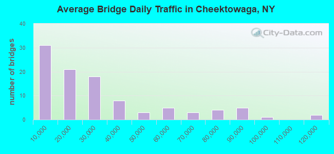
- 2,744,443Total average daily traffic
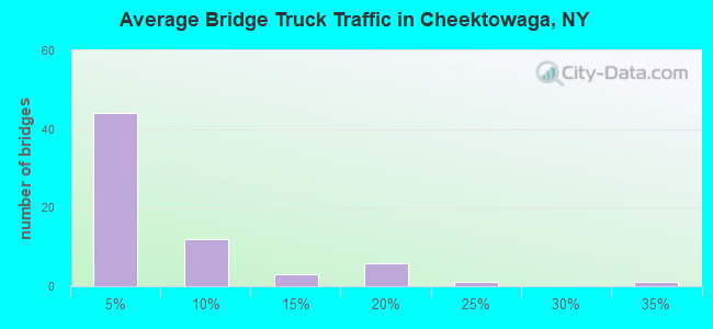
- 106,507Total average daily truck traffic
- National Bridge Inventory (NBI) Registered Bridges for Cheektowaga
- No street view available for this location
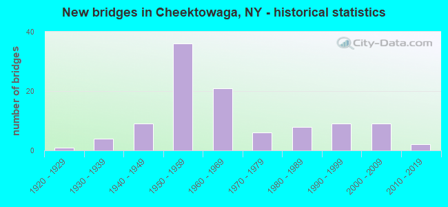
- New bridges - historical statistics
- 11920-1929
- 41930-1939
- 91940-1949
- 361950-1959
- 211960-1969
- 61970-1979
- 81980-1989
- 91990-1999
- 92000-2009
- 22010-2019
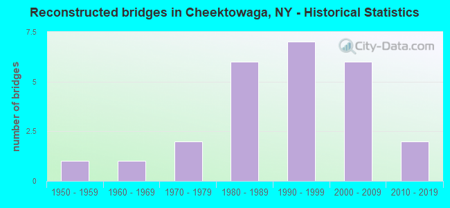
- Reconstructed bridges - Historical Statistics
- 11950-1959
- 11960-1969
- 21970-1979
- 61980-1989
- 71990-1999
- 62000-2009
- 22010-2019
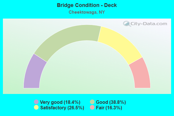
- Bridge Condition - Deck
- 18.4%Very good
- 38.8%Good
- 26.5%Satisfactory
- 16.3%Fair
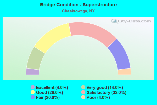
- Bridge Condition - Superstructure
- 4.0%Excellent
- 14.0%Very good
- 26.0%Good
- 32.0%Satisfactory
- 20.0%Fair
- 4.0%Poor
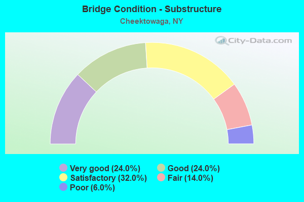
- Bridge Condition - Substructure
- 24.0%Very good
- 24.0%Good
- 32.0%Satisfactory
- 14.0%Fair
- 6.0%Poor
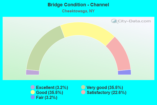
- Bridge Condition - Channel
- 3.2%Excellent
- 35.5%Very good
- 35.5%Good
- 22.6%Satisfactory
- 3.2%Fair
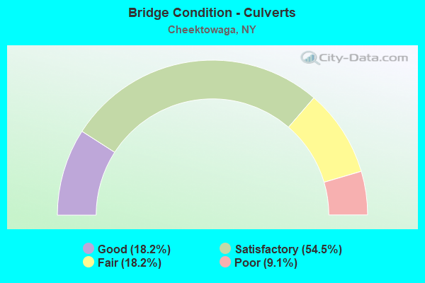
- Bridge Condition - Culverts
- 18.2%Good
- 54.5%Satisfactory
- 18.2%Fair
- 9.1%Poor
Find on map >> Show street view
Structure Number: 5512069, Location: 3.4 MI S JCT I90(Lat: 42.884033, Lng: -78.768078), Route carried "under" structure: County highway , Year Built: 1953, Structure Length: 0. m, Average Daily Traffic: 25,871 (year 2019), Truck Traffic: 3%, Features Intersected: WILLIAM ST, Facility Carried by Structure: RTE I90
Minimum Vertical Clearance: 4.57m (14.99ft), Kilometerpoint: 2.558, Lanes on structure: 6, Lanes under structure: 5, Material/Design: Steel continuous, Design/Construction: Stringer/Multi-beam, Length of Maximum Span: 20.4m (66.9ft)
Structure Number: 5512069, Location: 3.4 MI S JCT I90
Minimum Vertical Clearance: 4.57m (14.99ft), Kilometerpoint: 2.558, Lanes on structure: 6, Lanes under structure: 5, Material/Design: Steel continuous, Design/Construction: Stringer/Multi-beam, Length of Maximum Span: 20.4m (66.9ft)
Find on map >> Show street view
Structure Number: 551216, Location: .9 MI W JCT I90 & SH 78 (Lat: 42.950392, Lng: -78.703403), Route carried "under" structure: Interstate 90, Year Built: 1953, Structure Length: 0. m, Average Daily Traffic: 18,000 (year 1977), Features Intersected: 90IX WB, RTE I90
Minimum Vertical Clearance: 4.42m (14.50ft), Kilometerpoint: 671.387, Lanes on structure: 2, Lanes under structure: 2, Toll: On Interstate toll segment, Material/Design: Steel, Design/Construction: Stringer/Multi-beam, Length of Maximum Span: 19.8m (65.0ft)
Find on map >> Show street view
Structure Number: 551624, Location: .3 MI SW JCT I90 & SH 240 (Lat: 42.874658, Lng: -78.788142), Route carried "under" structure: Interstate 90, Year Built: 1957, Structure Length: 0. m, Average Daily Traffic: 110,356 (year 2015), Features Intersected: 90 IX, RTE I90, 190IX SB
Minimum Vertical Clearance: 4.62m (15.16ft), Kilometerpoint: 685.724, Lanes on structure: 2, Lanes under structure: 3, Toll: On Interstate toll segment, Material/Design: Steel, Design/Construction: Stringer/Multi-beam, Length of Maximum Span: 25.3m (83.0ft)
Find on map >> Show street view
Structure Number: 551624, Location: .3 MI SW JCT I90 & SH 240 (Lat: 42.874658, Lng: -78.788142), Route carried "under" structure: Interstate , Year Built: 1957, Structure Length: 0. m, Average Daily Traffic: 23,609 (year 2011), Features Intersected: 90 IX, RTE I90, 190IX SB, Facility Carried by Structure: RTE I90
Minimum Vertical Clearance: 4.50m (14.76ft), Kilometerpoint: 0.402, Lanes on structure: 2, Lanes under structure: 2, Toll: On toll road, Material/Design: Steel, Design/Construction: Stringer/Multi-beam, Length of Maximum Span: 25.3m (83.0ft)
Find on map >> Show street view
Structure Number: 551625, Location: .2 MI SW JCT I90 & SH 240 (Lat: 42.874889, Lng: -78.788442), Route carried "under" structure: Interstate 90, Year Built: 1957, Structure Length: 0. m, Average Daily Traffic: 110,356 (year 2015), Features Intersected: 90IX EB, RTE I90, 90IX E
Minimum Vertical Clearance: 5.31m (17.42ft), Kilometerpoint: 685.708, Lanes on structure: 2, Lanes under structure: 3, Toll: On Interstate toll segment, Material/Design: Steel, Design/Construction: Stringer/Multi-beam, Length of Maximum Span: 26.5m (86.9ft)
Find on map >> Show street view
Structure Number: 551625, Location: .2 MI SW JCT I90 & SH 240 (Lat: 42.874889, Lng: -78.788442), Route carried "under" structure: Interstate , Year Built: 1957, Structure Length: 0. m, Average Daily Traffic: 23,609 (year 2011), Features Intersected: 90IX EB, RTE I90, 90IX E, Facility Carried by Structure: 190IX SB Ramp To 9
Minimum Vertical Clearance: 5.11m (16.77ft), Kilometerpoint: 0.611, Lanes on structure: 2, Lanes under structure: 2, Toll: On Interstate toll segment, Material/Design: Steel, Design/Construction: Stringer/Multi-beam, Length of Maximum Span: 26.5m (86.9ft)
Find on map >> Show street view
Structure Number: 7044291, Location: 0.4 MI S JCT RTS 277 +130 (Lat: 42.896819, Lng: -78.754339), Route carried "under" structure: State highway 277, Year Built: 1940, Structure Length: 0. m, Average Daily Traffic: 26,373 (year 2002), Features Intersected: RTE 277, Facility Carried by Structure: NORFOLK SOUTHERN
Minimum Vertical Clearance: 4.42m (14.50ft), Kilometerpoint: 25.261, Lanes under structure: 4, Material/Design: Steel, Design/Construction: Girder and Floorbeam System, Length of Maximum Span: 19.5m (64.0ft)
Find on map >> Show street view
Structure Number: 7044311, Location: 0.3 MI S JCT RTS 277 +130 (Lat: 42.898156, Lng: -78.754328), Route carried "under" structure: State highway 277, Year Built: 1941, Structure Length: 0. m, Average Daily Traffic: 26,373 (year 2002), Features Intersected: RTE 277, Facility Carried by Structure: NORFOLK SOUTHERN
Minimum Vertical Clearance: 4.95m (16.24ft), Kilometerpoint: 25.390, Lanes under structure: 4, Material/Design: Steel, Design/Construction: Girder and Floorbeam System, Length of Maximum Span: 19.5m (64.0ft)
Find on map >> Show street view
Structure Number: 7044312, Location: 0.3 MI S JCT RTS 277 +130 (Lat: 42.898083, Lng: -78.754325), Route carried "under" structure: State highway 277, Year Built: 1941, Structure Length: 0. m, Average Daily Traffic: 26,373 (year 2002), Features Intersected: RTE 277, Facility Carried by Structure: NORFOLK SOUTHERN
Minimum Vertical Clearance: 4.62m (15.16ft), Kilometerpoint: 25.390, Lanes under structure: 4, Material/Design: Steel, Design/Construction: Girder and Floorbeam System, Length of Maximum Span: 19.5m (64.0ft)
Find on map >> Show street view
Structure Number: 704432, Location: 0.03 MI N JCT RTS 277&130 (Lat: 42.904200, Lng: -78.754325), Route carried "under" structure: State highway 277, Year Built: 1941, Structure Length: 0. m, Average Daily Traffic: 30,891 (year 2002), Features Intersected: RTE 277, Facility Carried by Structure: CSX TRANSPRTATION
Minimum Vertical Clearance: 4.44m (14.57ft), Kilometerpoint: 26.066, Lanes under structure: 4, Material/Design: Steel, Design/Construction: Stringer/Multi-beam, Length of Maximum Span: 15.2m (49.9ft)
Find on map >> Show street view
Structure Number: 770166, Location: 1.6 MI W JCT RTS 130 & 78 (Lat: 42.907167, Lng: -78.728603), Route carried "under" structure: County highway , Year Built: 1976, Structure Length: 0. m, Average Daily Traffic: 39,000 (year 1976), Features Intersected: DICK ROAD-CR 317, Facility Carried by Structure: CSX TRANSPRTATION
Minimum Vertical Clearance: 4.57m (14.99ft), Kilometerpoint: 0.241, Lanes under structure: 4, Material/Design: Steel, Design/Construction: Stringer/Multi-beam, Length of Maximum Span: 26.2m (86.0ft)
Find on map >> Show street view
Structure Number: 771456, Location: 0.1 MI N JCT I90 &RTE 130 (Lat: 42.902717, Lng: -78.766839), Route carried "under" structure: Interstate 90, Year Built: 1951, Structure Length: 0. m, Average Daily Traffic: 59,700 (year 1971), Features Intersected: 90IX EB, RTE I90, Facility Carried by Structure: CSXT RR / AMTRAK
Minimum Vertical Clearance: 4.45m (14.60ft), Kilometerpoint: 681.621, Lanes under structure: 3, Toll: On Interstate toll segment, Material/Design: Steel continuous, Design/Construction: Stringer/Multi-beam, Length of Maximum Span: 18.3m (60.0ft)
Find on map >> Show street view
Structure Number: 771456, Location: 0.1 MI N JCT I90 &RTE 130 (Lat: 42.902717, Lng: -78.766839), Route carried "under" structure: Interstate , Year Built: 1951, Structure Length: 0. m, Features Intersected: 90IX EB, RTE I90, Facility Carried by Structure: CSXT RR / AMTRAK
Minimum Vertical Clearance: 4.45m (14.60ft), Kilometerpoint: 681.621, Lanes under structure: 3, Toll: On Interstate toll segment, Material/Design: Steel continuous, Design/Construction: Stringer/Multi-beam, Length of Maximum Span: 18.3m (60.0ft)