Bridge Statistics for Cheektowaga, New York (NY)
Condition, Traffic, Stress, Structural Evaluation, Project Costs
- National Bridge Inventory (NBI) Statistics
- 105Number of bridges
- 866ft / 264mTotal length
- $355,108,000Total costs
- 2,744,443Total average daily traffic
- 106,507Total average daily truck traffic
- National Bridge Inventory (NBI) Registered Bridges for Cheektowaga
- No street view available for this location
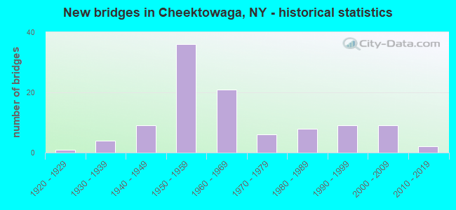
- New bridges - historical statistics
- 11920-1929
- 41930-1939
- 91940-1949
- 361950-1959
- 211960-1969
- 61970-1979
- 81980-1989
- 91990-1999
- 92000-2009
- 22010-2019
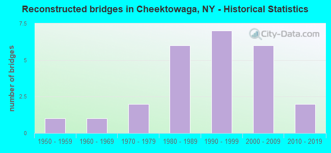
- Reconstructed bridges - Historical Statistics
- 11950-1959
- 11960-1969
- 21970-1979
- 61980-1989
- 71990-1999
- 62000-2009
- 22010-2019
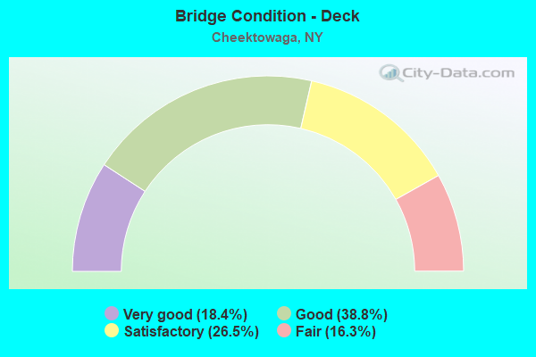
- Bridge Condition - Deck
- 18.4%Very good
- 38.8%Good
- 26.5%Satisfactory
- 16.3%Fair
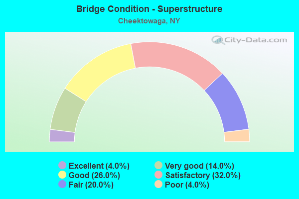
- Bridge Condition - Superstructure
- 4.0%Excellent
- 14.0%Very good
- 26.0%Good
- 32.0%Satisfactory
- 20.0%Fair
- 4.0%Poor
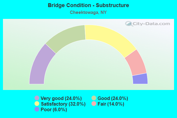
- Bridge Condition - Substructure
- 24.0%Very good
- 24.0%Good
- 32.0%Satisfactory
- 14.0%Fair
- 6.0%Poor
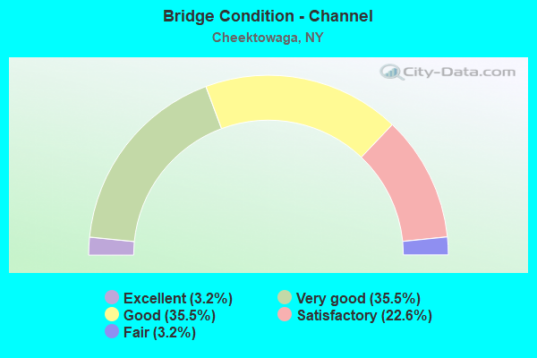
- Bridge Condition - Channel
- 3.2%Excellent
- 35.5%Very good
- 35.5%Good
- 22.6%Satisfactory
- 3.2%Fair
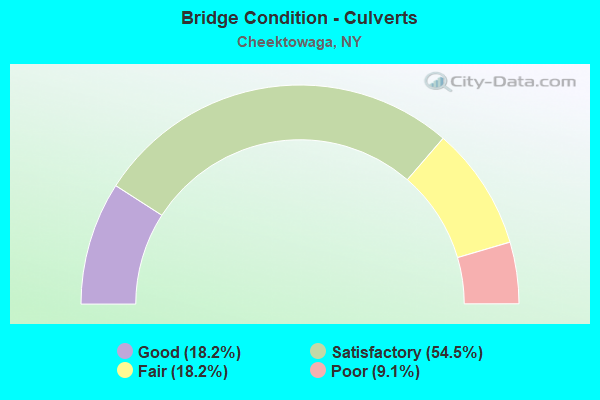
- Bridge Condition - Culverts
- 18.2%Good
- 54.5%Satisfactory
- 18.2%Fair
- 9.1%Poor
Find on map >> Show street view
Structure Number: 3327, Location: IN BELLEVUE (Lat: 42.894306, Lng: -78.731944), Route carried "on" structure: County highway , Year Built: 1998, Status: Open, Structure Length: 4.66m (15.29ft), Average Daily Traffic: 1,119 (year 2016), Truck Traffic: 4%, Average Future Daily Traffic: 1,567 (year 2036), Design Load: HS 25 or greater, Features Intersected: CAYUGA CREEK, Facility Carried by Structure: ROWLEY ROAD
Minimum Vertical Clearance: 30+ m (98+ ft), Kilometerpoint: 0.257, Lanes on structure: 2, Owner: County Highway Agency, Approaching Roadway Width: 9.8m (32.2ft), Material/Design: Prestressed concrete, Design/Construction: Box Beam or Girders - Multiple, Number Of Spans In Main Unit: 3, Length of Maximum Span: 26.8m (87.9ft), Curb-To-Curb Width: 10.0m (32.8ft), Out-to-Out Width: 10.5m (34.4ft)
Condition: Deck: Very good, Superstructure: Very good, Substructure: Very good, Channel: Excellent, Operating Rating: 79.8 metric tons, Method Used To Determine Operating Rating: Load Factor (LF), Inventory Rating: 44.5 metric tons, Method Used To Determine Inventory Rating: Load Factor (LF), Structural Evaluation: Equal to present desirable criteria, Deck Geometry: Somewhat better than minimum adequacy, Waterway Adequacy: Equal to present minimum criteria, Approach Roadway Alignment: Equal to present desirable criteria, Length Of Structure Improvement: 4.66m (15.29ft), Designated Inspection Frequency: Every 24 months, Inspection Date: November 2020, Bridge Improvement Cost: $1,277,000, Roadway Improvement Cost: $748,000, Total Project Cost: $2,025,000 ( Estimate for 2021), Wearing Surface/Protective System: Wearing Surface: Integral Concrete
Find on map >> Show street view
Structure Number: 332714, Location: 1.5 MI S JCT I90 & SH 33 (Lat: 42.918881, Lng: -78.775664), Route carried "on" structure: County highway , Year Built: 1957, Status: Open, Structure Length: 0.76m (2.49ft), Average Daily Traffic: 5,662 (year 2017), Truck Traffic: 1%, Average Future Daily Traffic: 5,979 (year 2040), Features Intersected: BR SCAJAQUADA CRK, Facility Carried by Structure: GEORGE URBAN BLVD
Minimum Vertical Clearance: 30+ m (98+ ft), Kilometerpoint: 1.175, Lanes on structure: 2, Owner: County Highway Agency, Approaching Roadway Width: 11.6m (38.1ft), Material/Design: Concrete continuous, Design/Construction: Culvert, Number Of Spans In Main Unit: 2, Length of Maximum Span: 3.0m (9.8ft), Curb or Sidewalk Widths: Left: 0.8m (2.6ft), Right: 0.9m (3.0ft)
Condition: Channel: Satisfactory, Culverts: Satisfactory, Operating Rating: 74.8 metric tons, Method Used To Determine Operating Rating: Field evaluation and documented engineering judgment, Inventory Rating: 32.7 metric tons, Method Used To Determine Inventory Rating: Field evaluation and documented engineering judgment, Structural Evaluation: Equal to present minimum criteria, Waterway Adequacy: Equal to present desirable criteria, Approach Roadway Alignment: Equal to present desirable criteria, Length Of Structure Improvement: 0.76m (2.49ft), Designated Inspection Frequency: Every 24 months, Inspection Date: April 2020, Bridge Improvement Cost: $244,000, Roadway Improvement Cost: $143,000, Total Project Cost: $387,000 ( Estimate for 2021), Wearing Surface/Protective System: Wearing Surface: Bituminous
Find on map >> Show street view
Structure Number: 332715, Location: 1.5 MI S JCT I90 & SH 33 (Lat: 42.918856, Lng: -78.769489), Route carried "on" structure: County highway , Year Built: 1930, Year Reconstructed: 2011, Status: Open, Structure Length: 0.73m (2.40ft), Average Daily Traffic: 5,662 (year 2017), Truck Traffic: 1%, Average Future Daily Traffic: 5,979 (year 2040), Design Load: HS 25 or greater, Features Intersected: SCAJAQUADA CREEK, Facility Carried by Structure: GEORGE URBAN BLVD
Minimum Vertical Clearance: 30+ m (98+ ft), Kilometerpoint: 1.689, Lanes on structure: 2, Owner: County Highway Agency, Approaching Roadway Width: 12.5m (41.0ft), Skew: 4 degrees, Material/Design: Steel, Design/Construction: Culvert, Number Of Spans In Main Unit: 2, Length of Maximum Span: 2.7m (8.9ft)
Condition: Channel: Satisfactory, Culverts: Satisfactory, Operating Rating: 74.5 metric tons, Method Used To Determine Operating Rating: Field evaluation and documented engineering judgment, Inventory Rating: 40.8 metric tons, Method Used To Determine Inventory Rating: Field evaluation and documented engineering judgment, Structural Evaluation: Equal to present minimum criteria, Waterway Adequacy: Superior to present desirable criteria, Approach Roadway Alignment: Equal to present desirable criteria, Length Of Structure Improvement: 0.73m (2.40ft), Designated Inspection Frequency: Every 24 months, Inspection Date: September 2021, Bridge Improvement Cost: $253,000, Roadway Improvement Cost: $148,000, Total Project Cost: $400,000 ( Estimate for 2021)
Find on map >> Show street view
Structure Number: 33272, Location: .8 MI N JCT US 20 & SH354 (Lat: 42.867867, Lng: -78.701028), Route carried "on" structure: County highway , Year Built: 1967, Status: Open, Structure Length: 1.13m (3.71ft), Average Daily Traffic: 11,204 (year 2018), Truck Traffic: 2%, Average Future Daily Traffic: 11,831 (year 2040), Features Intersected: SLATE BOTTOM CRK, Facility Carried by Structure: FRENCH ROAD
Minimum Vertical Clearance: 30+ m (98+ ft), Kilometerpoint: 4.409, Lanes on structure: 5, Owner: County Highway Agency, Approaching Roadway Width: 15.8m (51.8ft), Skew: 4 degrees, Material/Design: Prestressed concrete, Design/Construction: Box Beam or Girders - Multiple, Number Of Spans In Main Unit: 1, Length of Maximum Span: 10.6m (34.8ft), Curb or Sidewalk Widths: Left: 1.3m (4.3ft), Right: 1.2m (3.9ft), Curb-To-Curb Width: 17.7m (58.1ft), Out-to-Out Width: 20.9m (68.6ft)
Condition: Deck: Satisfactory, Superstructure: Fair, Substructure: Fair, Channel: Satisfactory, Operating Rating: 50.8 metric tons, Method Used To Determine Operating Rating: Load Factor (LF), Inventory Rating: 29.9 metric tons, Method Used To Determine Inventory Rating: Load Factor (LF), Structural Evaluation: Somewhat better than minimum adequacy, Deck Geometry: High priority of replacement, Waterway Adequacy: Somewhat better than minimum adequacy, Approach Roadway Alignment: Equal to present desirable criteria, Length Of Structure Improvement: 1.12m (3.67ft), Designated Inspection Frequency: Every 24 months, Inspection Date: August 2020, Bridge Improvement Cost: $1,313,000, Roadway Improvement Cost: $769,000, Total Project Cost: $2,082,000 ( Estimate for 2021), Wearing Surface/Protective System: Wearing Surface: Bituminous
Find on map >> Show street view
Structure Number: 332721, Location: 1 MI N JCT SH 78 & SH 354 (Lat: 42.868417, Lng: -78.708953), Route carried "on" structure: County highway , Year Built: 1976, Status: Open, Structure Length: 1.13m (3.71ft), Average Daily Traffic: 9,485 (year 2020), Truck Traffic: 1%, Average Future Daily Traffic: 10,016 (year 2040), Features Intersected: SLATE BOTTOM CRK, Facility Carried by Structure: BORDEN ROAD
Minimum Vertical Clearance: 30+ m (98+ ft), Kilometerpoint: 1.883, Lanes on structure: 2, Owner: County Highway Agency, Approaching Roadway Width: 12.2m (40.0ft), Skew: 20 degrees, Material/Design: Prestressed concrete, Design/Construction: Box Beam or Girders - Multiple, Number Of Spans In Main Unit: 1, Length of Maximum Span: 10.9m (35.8ft), Curb or Sidewalk Widths: Left: 2.3m (7.5ft), Right: 2.3m (7.5ft), Curb-To-Curb Width: 12.3m (40.4ft), Out-to-Out Width: 17.5m (57.4ft)
Condition: Deck: Satisfactory, Superstructure: Satisfactory, Substructure: Satisfactory, Channel: Very good, Operating Rating: 56.2 metric tons, Method Used To Determine Operating Rating: Load Factor (LF), Inventory Rating: 29.9 metric tons, Method Used To Determine Inventory Rating: Load Factor (LF), Structural Evaluation: Equal to present minimum criteria, Deck Geometry: Somewhat better than minimum adequacy, Waterway Adequacy: Equal to present desirable criteria, Approach Roadway Alignment: Equal to present desirable criteria, Length Of Structure Improvement: 1.12m (3.67ft), Designated Inspection Frequency: Every 24 months, Inspection Date: April 2020, Bridge Improvement Cost: $850,000, Roadway Improvement Cost: $498,000, Total Project Cost: $1,348,000 ( Estimate for 2021), Wearing Surface/Protective System: Wearing Surface: Bituminous, Membrane: Other
Find on map >> Show street view
Structure Number: 332723, Location: .3 MI N JCT SH 33 & CR539 (Lat: 42.941064, Lng: -78.717153), Route carried "on" structure: County highway , Year Built: 1936, Status: Posted for load, Structure Length: 2.65m (8.69ft), Average Daily Traffic: 3,281 (year 2020), Truck Traffic: 7%, Average Future Daily Traffic: 3,464 (year 2040), Features Intersected: ELLICOTT CREEK, Facility Carried by Structure: AERO DRIVE
Minimum Vertical Clearance: 30+ m (98+ ft), Kilometerpoint: 2.027, Lanes on structure: 2, Owner: County Highway Agency, Approaching Roadway Width: 7.3m (24.0ft), Skew: 3 degrees, Material/Design: Steel, Design/Construction: Truss - Thru, Number Of Spans In Main Unit: 1, Length of Maximum Span: 25.2m (82.7ft), Curb-To-Curb Width: 7.3m (24.0ft), Out-to-Out Width: 7.7m (25.3ft)
Condition: Deck: Satisfactory, Superstructure: Poor, Substructure: Satisfactory, Channel: Satisfactory, Operating Rating: 30.8 metric tons, Method Used To Determine Operating Rating: Allowable Stress (AS), Inventory Rating: 18.1 metric tons, Method Used To Determine Inventory Rating: Allowable Stress (AS), Structural Evaluation: Meets minimum limits, Deck Geometry: High priority of replacement, Waterway Adequacy: Equal to present minimum criteria, Approach Roadway Alignment: Meets minimum limits, Bridge Posting: Required (Relationship of Operating Rating to Maximum Legal Load: > 39.9% below), Length Of Structure Improvement: 2.65m (8.69ft), Designated Inspection Frequency: Every 12 months, Critical Feature Inspection Frequency: Every 12 months, Inspection Date: November 2021, Critical Feature Inspection Date: November 2021, Bridge Improvement Cost: $2,217,000, Roadway Improvement Cost: $1,298,000, Total Project Cost: $3,515,000 ( Estimate for 2021), Deck Structure Type: Concrete Cast-file-Place, Wearing Surface/Protective System: Wearing Surface: Integral Concrete, Deck Protection: Epoxy Coated Reinforcing
Find on map >> Show street view
Structure Number: 332873, Location: 1 MI SW JCT SH 78 & US 20 (Lat: 42.893439, Lng: -78.731953), Route carried "on" structure: County highway , Year Built: 1984, Status: Open, Structure Length: 5.30m (17.39ft), Average Daily Traffic: 5,643 (year 2020), Truck Traffic: 4%, Average Future Daily Traffic: 5,959 (year 2040), Design Load: HS 20, Features Intersected: CAYUGA CREEK, Facility Carried by Structure: COMO PARK BLVD
Minimum Vertical Clearance: 30+ m (98+ ft), Kilometerpoint: 1.818, Lanes on structure: 2, Owner: County Highway Agency, Approaching Roadway Width: 13.4m (44.0ft), Material/Design: Prestressed concrete, Design/Construction: Box Beam or Girders - Multiple, Number Of Spans In Main Unit: 3, Length of Maximum Span: 22.8m (74.8ft), Curb or Sidewalk Widths: Left: 0.0m, Right: 1.5m (4.9ft), Curb-To-Curb Width: 13.4m (44.0ft), Out-to-Out Width: 15.6m (51.2ft)
Condition: Deck: Good, Superstructure: Good, Substructure: Very good, Channel: Very good, Operating Rating: 67.7 metric tons, Method Used To Determine Operating Rating: Load and Resistance Factor Rating (LRFR) rating reported by rating factor(RF) method using HL-93 loadings, Inventory Rating: 48.0 metric tons, Method Used To Determine Inventory Rating: Load and Resistance Factor Rating (LRFR) rating reported by rating factor(RF) method using HL-93 loadings, Structural Evaluation: Better than present minimum criteria, Deck Geometry: Equal to present minimum criteria, Waterway Adequacy: Equal to present minimum criteria, Approach Roadway Alignment: Equal to present desirable criteria, Length Of Structure Improvement: 5.30m (17.39ft), Designated Inspection Frequency: Every 24 months, Inspection Date: August 2020, Bridge Improvement Cost: $2,072,000, Roadway Improvement Cost: $1,213,000, Total Project Cost: $3,285,000 ( Estimate for 2021), Deck Structure Type: Concrete Cast-file-Place, Wearing Surface/Protective System: Wearing Surface: Integral Concrete, Deck Protection: Epoxy Coated Reinforcing
Find on map >> Show street view
Structure Number: 5030279, Location: JCT RT 78 + I-90 (Lat: 42.949917, Lng: -78.696939), Route carried "on" structure: Interstate 90, Year Built: 1957, Year Reconstructed: 1979, Status: Open, Structure Length: 4.91m (16.11ft), Average Daily Traffic: 25,987 (year 2017), Truck Traffic: 31%, Average Future Daily Traffic: 29,123 (year 2040), Design Load: HS 20+Mod, Features Intersected: RTE 78
Minimum Vertical Clearance: 30+ m (98+ ft), Kilometerpoint: 60.386, Lanes on structure: 5, Lanes under structure: 5, Base Highway Network: Yes, Toll: On Interstate toll segment, Owner: State Toll Authority, Approaching Roadway Width: 33.5m (109.9ft), Skew: 20 degrees, Material/Design: Steel, Design/Construction: Stringer/Multi-beam, Number Of Spans In Main Unit: 3, Length of Maximum Span: 22.9m (75.1ft), Curb-To-Curb Width: 37.5m (123.0ft), Out-to-Out Width: 38.1m (125.0ft)
Condition: Deck: Fair, Superstructure: Fair, Substructure: Satisfactory, Operating Rating: 62.6 metric tons, Method Used To Determine Operating Rating: Load Factor (LF), Inventory Rating: 37.2 metric tons, Method Used To Determine Inventory Rating: Load Factor (LF), Structural Evaluation: Somewhat better than minimum adequacy, Deck Geometry: Superior to present desirable criteria, Underclear: Meets minimum limits, Approach Roadway Alignment: Equal to present desirable criteria, Length Of Structure Improvement: 4.90m (16.08ft), Designated Inspection Frequency: Every 24 months, Inspection Date: June 2020, Bridge Improvement Cost: $6,769,000, Roadway Improvement Cost: $3,964,000, Total Project Cost: $10,733,000 ( Estimate for 2021), Deck Structure Type: Concrete Cast-file-Place, Wearing Surface/Protective System: Wearing Surface: Bituminous, Deck Protection: Epoxy Coated Reinforcing
Find on map >> Show street view
Structure Number: 5042639, Location: JCT S.H.240 & I90 (Lat: 42.876403, Lng: -78.784783), Route carried "on" structure: Interstate 90, Year Built: 2002, Status: Open, Structure Length: 4.05m (13.29ft), Average Daily Traffic: 82,390 (year 2020), Truck Traffic: 16%, Average Future Daily Traffic: 92,334 (year 2040), Design Load: HS 25 or greater, Features Intersected: RTE 240
Minimum Vertical Clearance: 30+ m (98+ ft), Kilometerpoint: 45.857, Lanes on structure: 7, Lanes under structure: 5, Base Highway Network: Yes, Toll: On Interstate toll segment, Owner: State Toll Authority, Approaching Roadway Width: 37.8m (124.0ft), Skew: 21 degrees, Material/Design: Steel, Design/Construction: Stringer/Multi-beam, Number Of Spans In Main Unit: 1, Length of Maximum Span: 39.0m (128.0ft), Curb-To-Curb Width: 37.6m (123.4ft), Out-to-Out Width: 39.4m (129.3ft)
Condition: Deck: Very good, Superstructure: Very good, Substructure: Very good, Operating Rating: 79.8 metric tons, Method Used To Determine Operating Rating: Load Factor (LF), Inventory Rating: 48.1 metric tons, Method Used To Determine Inventory Rating: Load Factor (LF), Structural Evaluation: Equal to present desirable criteria, Deck Geometry: Superior to present desirable criteria, Underclear: Equal to present minimum criteria, Approach Roadway Alignment: Equal to present desirable criteria, Length Of Structure Improvement: 4.05m (13.29ft), Designated Inspection Frequency: Every 24 months, Inspection Date: April 2021, Bridge Improvement Cost: $7,984,000, Roadway Improvement Cost: $4,675,000, Total Project Cost: $12,659,000 ( Estimate for 2021), Deck Structure Type: Concrete Cast-file-Place, Wearing Surface/Protective System: Wearing Surface: Integral Concrete, Deck Protection: Galvanized Reinforcing
Find on map >> Show street view
Structure Number: 5046479, Location: .1 MI W JCT SH240 & SH354 (Lat: 42.871519, Lng: -78.790097), Route carried "on" structure: Interstate 90, Year Built: 2002, Status: Open, Structure Length: 3.51m (11.52ft), Average Daily Traffic: 82,390 (year 2020), Truck Traffic: 16%, Average Future Daily Traffic: 92,334 (year 2040), Design Load: HS 25 or greater, Features Intersected: NY 354 CLINTON ST
Minimum Vertical Clearance: 30+ m (98+ ft), Kilometerpoint: 45.132, Lanes on structure: 10, Lanes under structure: 4, Base Highway Network: Yes, Toll: On Interstate toll segment, Owner: State Toll Authority, Approaching Roadway Width: 48.8m (160.1ft), Skew: 20 degrees, Material/Design: Steel, Design/Construction: Stringer/Multi-beam, Number Of Spans In Main Unit: 1, Length of Maximum Span: 33.5m (109.9ft), Curb-To-Curb Width: 49.9m (163.7ft), Out-to-Out Width: 51.1m (167.7ft)
Condition: Deck: Good, Superstructure: Excellent, Substructure: Very good, Operating Rating: 17.5 metric tons, Method Used To Determine Operating Rating: Load and Resistance Factor Rating (LRFR) rating reported by rating factor(RF) method using HL-93 loadings, Inventory Rating: 13.6 metric tons, Method Used To Determine Inventory Rating: Load and Resistance Factor Rating (LRFR) rating reported by rating factor(RF) method using HL-93 loadings, Structural Evaluation: High priority of corrective action, Deck Geometry: Superior to present desirable criteria, Underclear: Somewhat better than minimum adequacy, Approach Roadway Alignment: Equal to present desirable criteria, Length Of Structure Improvement: 3.50m (11.48ft), Designated Inspection Frequency: Every 24 months, Inspection Date: November 2020, Bridge Improvement Cost: $9,215,000, Roadway Improvement Cost: $5,396,000, Total Project Cost: $14,611,000 ( Estimate for 2021), Deck Structure Type: Concrete Cast-file-Place, Wearing Surface/Protective System: Wearing Surface: Integral Concrete, Deck Protection: Galvanized Reinforcing
Find on map >> Show street view
Structure Number: 506312, Location: JCT RTS 240 + I-90 (Lat: 42.876200, Lng: -78.784792), Route carried "on" structure: Ramp Interstate 190, Year Built: 1957, Year Reconstructed: 2000, Status: Open, Structure Length: 5.73m (18.80ft), Average Daily Traffic: 12,037 (year 2019), Truck Traffic: 15%, Average Future Daily Traffic: 13,489 (year 2040), Design Load: HS 20, Features Intersected: RTE 240
Minimum Vertical Clearance: 30+ m (98+ ft), Kilometerpoint: 0.724, Lanes on structure: 2, Lanes under structure: 5, Toll: On Interstate toll segment, Owner: State Toll Authority, Approaching Roadway Width: 10.7m (35.1ft), Skew: 3 degrees, Material/Design: Steel, Design/Construction: Stringer/Multi-beam, Number Of Spans In Main Unit: 3, Length of Maximum Span: 24.4m (80.1ft), Curb-To-Curb Width: 8.5m (27.9ft), Out-to-Out Width: 10.7m (35.1ft)
Condition: Deck: Satisfactory, Superstructure: Satisfactory, Substructure: Satisfactory, Operating Rating: 58.3 metric tons, Method Used To Determine Operating Rating: Load and Resistance Factor Rating (LRFR) rating reported by rating factor(RF) method using HL-93 loadings, Inventory Rating: 45.0 metric tons, Method Used To Determine Inventory Rating: Load and Resistance Factor Rating (LRFR) rating reported by rating factor(RF) method using HL-93 loadings, Structural Evaluation: Equal to present minimum criteria, Deck Geometry: High priority of corrective action, Underclear: High priority of corrective action, Approach Roadway Alignment: Equal to present desirable criteria, Length Of Structure Improvement: 5.73m (18.80ft), Designated Inspection Frequency: Every 24 months, Inspection Date: May 2020, Bridge Improvement Cost: $2,559,000, Roadway Improvement Cost: $1,498,000, Total Project Cost: $4,057,000 ( Estimate for 2021), Deck Structure Type: Concrete Cast-file-Place, Wearing Surface/Protective System: Wearing Surface: Bituminous, Membrane: Other
Find on map >> Show street view
Structure Number: 551172, Location: 0.4 MI E I190 TOLLGATE (Lat: 42.876089, Lng: -78.794869), Route carried "on" structure: Other road , Year Built: 1956, Status: Open, Structure Length: 6.07m (19.91ft), Average Daily Traffic: 4,558 (year 2017), Truck Traffic: 2%, Average Future Daily Traffic: 4,813 (year 2040), Design Load: HS 20+Mod, Features Intersected: 190IX NB, RTE I190, Facility Carried by Structure: Rossler Avenue
Minimum Vertical Clearance: 30+ m (98+ ft), Kilometerpoint: 0.467, Lanes on structure: 2, Lanes under structure: 12, Owner: State Toll Authority, Approaching Roadway Width: 8.5m (27.9ft), Material/Design: Steel continuous, Design/Construction: Stringer/Multi-beam, Number Of Spans In Main Unit: 4, Length of Maximum Span: 18.0m (59.1ft), Curb or Sidewalk Widths: Left: 1.5m (4.9ft), Right: 1.5m (4.9ft), Curb-To-Curb Width: 8.5m (27.9ft), Out-to-Out Width: 11.7m (38.4ft)
Condition: Deck: Fair, Superstructure: Satisfactory, Substructure: Fair, Operating Rating: 48.1 metric tons, Method Used To Determine Operating Rating: Load Factor (LF), Inventory Rating: 29.0 metric tons, Method Used To Determine Inventory Rating: Load Factor (LF), Structural Evaluation: Somewhat better than minimum adequacy, Deck Geometry: Meets minimum limits, Underclear: High priority of corrective action, Approach Roadway Alignment: Equal to present minimum criteria, Length Of Structure Improvement: 6.06m (19.88ft), Designated Inspection Frequency: Every 24 months, Inspection Date: September 2020, Bridge Improvement Cost: $2,553,000, Roadway Improvement Cost: $1,495,000, Total Project Cost: $4,047,000 ( Estimate for 2021), Deck Structure Type: Concrete Cast-file-Place, Wearing Surface/Protective System: Wearing Surface: Bituminous, Membrane: Other
Find on map >> Show street view
Structure Number: 551173, Location: 0.5 MI E JCT I90 & RT 240 (Lat: 42.879103, Lng: -78.774136), Route carried "on" structure: Other road , Year Built: 1996, Status: Open, Structure Length: 6.80m (22.31ft), Average Daily Traffic: 903 (year 2019), Truck Traffic: 2%, Average Future Daily Traffic: 1,264 (year 2039), Design Load: HS 25 or greater, Features Intersected: RTE I90, Facility Carried by Structure: HENRY ST
Minimum Vertical Clearance: 30+ m (98+ ft), Kilometerpoint: 0.177, Lanes on structure: 2, Lanes under structure: 4, Owner: State Toll Authority, Approaching Roadway Width: 9.1m (29.9ft), Skew: 1 degrees, Material/Design: Steel continuous, Design/Construction: Stringer/Multi-beam, Number Of Spans In Main Unit: 2, Length of Maximum Span: 33.5m (109.9ft), Curb or Sidewalk Widths: Left: 1.5m (4.9ft), Right: 1.5m (4.9ft), Curb-To-Curb Width: 9.1m (29.9ft), Out-to-Out Width: 12.8m (42.0ft)
Condition: Deck: Good, Superstructure: Good, Substructure: Very good, Operating Rating: 82.6 metric tons, Method Used To Determine Operating Rating: Load Factor (LF), Inventory Rating: 45.4 metric tons, Method Used To Determine Inventory Rating: Load Factor (LF), Structural Evaluation: Better than present minimum criteria, Deck Geometry: Equal to present minimum criteria, Underclear: High priority of corrective action, Approach Roadway Alignment: Equal to present desirable criteria, Length Of Structure Improvement: 6.79m (22.28ft), Designated Inspection Frequency: Every 24 months, Inspection Date: November 2020, Bridge Improvement Cost: $3,118,000, Roadway Improvement Cost: $1,826,000, Total Project Cost: $4,944,000 ( Estimate for 2021), Deck Structure Type: Concrete Cast-file-Place, Wearing Surface/Protective System: Wearing Surface: Integral Concrete, Deck Protection: Galvanized Reinforcing
Find on map >> Show street view
Structure Number: 55119, Location: 3.8 MI W JCT I90 < RTE 78 (Lat: 42.950658, Lng: -78.724711), Route carried "on" structure: County highway , Year Built: 1953, Year Reconstructed: 1993, Status: Open, Structure Length: 6.00m (19.69ft), Average Daily Traffic: 13,225 (year 2020), Truck Traffic: 3%, Average Future Daily Traffic: 13,965 (year 2040), Design Load: HS 20+Mod, Features Intersected: 90IX EB, RTE I90, Facility Carried by Structure: YOUNGS RD
Minimum Vertical Clearance: 30+ m (98+ ft), Kilometerpoint: 0.579, Lanes on structure: 2, Lanes under structure: 4, Owner: State Toll Authority, Approaching Roadway Width: 11.6m (38.1ft), Material/Design: Steel continuous, Design/Construction: Stringer/Multi-beam, Number Of Spans In Main Unit: 4, Length of Maximum Span: 18.0m (59.1ft), Curb-To-Curb Width: 11.3m (37.1ft), Out-to-Out Width: 11.9m (39.0ft)
Condition: Deck: Good, Superstructure: Satisfactory, Substructure: Satisfactory, Operating Rating: 79.8 metric tons, Method Used To Determine Operating Rating: Load Factor (LF), Inventory Rating: 50.8 metric tons, Method Used To Determine Inventory Rating: Load Factor (LF), Structural Evaluation: Equal to present minimum criteria, Deck Geometry: Meets minimum limits, Underclear: High priority of corrective action, Approach Roadway Alignment: Equal to present desirable criteria, Length Of Structure Improvement: 6.00m (19.69ft), Designated Inspection Frequency: Every 24 months, Inspection Date: April 2021, Bridge Improvement Cost: $2,576,000, Roadway Improvement Cost: $1,508,000, Total Project Cost: $4,084,000 ( Estimate for 2021), Deck Structure Type: Concrete Cast-file-Place, Wearing Surface/Protective System: Wearing Surface: Integral Concrete, Deck Protection: Epoxy Coated Reinforcing
Find on map >> Show street view
Structure Number: 5511919, Location: 4.7 MI.W.OF I90 & RT.78 (Lat: 42.950647, Lng: -78.732175), Route carried "on" structure: Interstate 90, Year Built: 1953, Year Reconstructed: 1999, Status: Open, Structure Length: 3.78m (12.40ft), Average Daily Traffic: 32,893 (year 2017), Truck Traffic: 23%, Average Future Daily Traffic: 36,863 (year 2040), Design Load: HS 20+Mod, Features Intersected: ELLICOTT CREEK
Minimum Vertical Clearance: 30+ m (98+ ft), Kilometerpoint: 57.506, Lanes on structure: 5, Base Highway Network: Yes, Toll: On Interstate toll segment, Owner: State Toll Authority, Approaching Roadway Width: 32.6m (107.0ft), Skew: 23 degrees, Material/Design: Steel, Design/Construction: Stringer/Multi-beam, Number Of Spans In Main Unit: 2, Length of Maximum Span: 17.7m (58.1ft), Curb-To-Curb Width: 32.6m (107.0ft), Out-to-Out Width: 34.4m (112.9ft)
Condition: Deck: Fair, Superstructure: Satisfactory, Substructure: Satisfactory, Channel: Good, Operating Rating: 70.3 metric tons, Method Used To Determine Operating Rating: Load and Resistance Factor Rating (LRFR) rating reported by rating factor(RF) method using HL-93 loadings, Inventory Rating: 54.1 metric tons, Method Used To Determine Inventory Rating: Load and Resistance Factor Rating (LRFR) rating reported by rating factor(RF) method using HL-93 loadings, Structural Evaluation: Equal to present minimum criteria, Deck Geometry: Superior to present desirable criteria, Waterway Adequacy: Meets minimum limits, Approach Roadway Alignment: Equal to present desirable criteria, Length Of Structure Improvement: 3.77m (12.37ft), Designated Inspection Frequency: Every 24 months, Inspection Date: June 2020, Bridge Improvement Cost: $5,940,000, Roadway Improvement Cost: $3,479,000, Total Project Cost: $9,419,000 ( Estimate for 2021), Deck Structure Type: Concrete Cast-file-Place, Wearing Surface/Protective System: Wearing Surface: Monolithic Concrete
Find on map >> Show street view
Structure Number: 5512, Location: 2.6 MI S JCT I290 < RTE 5 (Lat: 42.945197, Lng: -78.766092), Route carried "on" structure: County highway , Year Built: 2015, Status: Open, Structure Length: 6.74m (22.11ft), Average Daily Traffic: 7,836 (year 2020), Truck Traffic: 3%, Average Future Daily Traffic: 8,274 (year 2040), Design Load: HS 20+Mod, Features Intersected: 90IX EB, RTE I90, Facility Carried by Structure: CLEVELAND DR
Minimum Vertical Clearance: 30+ m (98+ ft), Kilometerpoint: 1.400, Lanes on structure: 3, Lanes under structure: 8, Owner: State Toll Authority, Approaching Roadway Width: 15.8m (51.8ft), Skew: 1 degrees, Material/Design: Steel, Design/Construction: Stringer/Multi-beam, Number Of Spans In Main Unit: 1, Length of Maximum Span: 67.1m (220.1ft), Curb or Sidewalk Widths: Left: 1.8m (5.9ft), Right: 1.8m (5.9ft), Curb-To-Curb Width: 14.0m (45.9ft), Out-to-Out Width: 18.3m (60.0ft)
Condition: Deck: Very good, Superstructure: Excellent, Substructure: Very good, Operating Rating: 68.0 metric tons, Method Used To Determine Operating Rating: Load Factor (LF), Inventory Rating: 40.8 metric tons, Method Used To Determine Inventory Rating: Load Factor (LF), Structural Evaluation: Equal to present desirable criteria, Deck Geometry: Somewhat better than minimum adequacy, Underclear: High priority of corrective action, Approach Roadway Alignment: Equal to present desirable criteria, Length Of Structure Improvement: 6.73m (22.08ft), Designated Inspection Frequency: Every 24 months, Inspection Date: November 2021, Bridge Improvement Cost: $5,717,000, Roadway Improvement Cost: $3,348,000, Total Project Cost: $9,064,000 ( Estimate for 2021), Deck Structure Type: Concrete Cast-file-Place, Wearing Surface/Protective System: Wearing Surface: Integral Concrete, Deck Protection: Galvanized Reinforcing
Find on map >> Show street view
Structure Number: 551201, Location: 3.0 MI N JCT I90(Lat: 42.918842, Lng: -78.766336), Route carried "on" structure: County highway , Year Built: 1950, Year Reconstructed: 1990, Status: Open, Structure Length: 6.22m (20.41ft), Average Daily Traffic: 5,662 (year 2017), Truck Traffic: 1%, Average Future Daily Traffic: 5,979 (year 2040), Design Load: HS 20+Mod, Features Intersected: 90IX EB, RTE I90, Facility Carried by Structure: GEORGE URBAN BLVD
Minimum Vertical Clearance: 30+ m (98+ ft), Kilometerpoint: 1.899, Lanes on structure: 2, Lanes under structure: 6, Owner: State Toll Authority, Approaching Roadway Width: 8.5m (27.9ft), Material/Design: Steel continuous, Design/Construction: Stringer/Multi-beam, Number Of Spans In Main Unit: 4, Length of Maximum Span: 18.3m (60.0ft), Curb or Sidewalk Widths: Left: 0.6m (2.0ft), Right: 1.2m (3.9ft), Curb-To-Curb Width: 8.5m (27.9ft), Out-to-Out Width: 11.1m (36.4ft)
Condition: Deck: Satisfactory, Superstructure: Satisfactory, Substructure: Poor, Operating Rating: 55.3 metric tons, Method Used To Determine Operating Rating: Load Factor (LF), Inventory Rating: 32.7 metric tons, Method Used To Determine Inventory Rating: Load Factor (LF), Structural Evaluation: Meets minimum limits, Deck Geometry: Meets minimum limits, Underclear: High priority of corrective action, Approach Roadway Alignment: Equal to present desirable criteria, Length Of Structure Improvement: 6.21m (20.37ft), Designated Inspection Frequency: Every 24 months, Inspection Date: June 2020, Bridge Improvement Cost: $2,531,000, Roadway Improvement Cost: $1,482,000, Total Project Cost: $4,013,000 ( Estimate for 2021), Deck Structure Type: Concrete Cast-file-Place, Wearing Surface/Protective System: Wearing Surface: Integral Concrete, Deck Protection: Epoxy Coated Reinforcing
Structure Number: 551201, Location: 3.0 MI N JCT I90
Minimum Vertical Clearance: 30+ m (98+ ft), Kilometerpoint: 1.899, Lanes on structure: 2, Lanes under structure: 6, Owner: State Toll Authority, Approaching Roadway Width: 8.5m (27.9ft), Material/Design: Steel continuous, Design/Construction: Stringer/Multi-beam, Number Of Spans In Main Unit: 4, Length of Maximum Span: 18.3m (60.0ft), Curb or Sidewalk Widths: Left: 0.6m (2.0ft), Right: 1.2m (3.9ft), Curb-To-Curb Width: 8.5m (27.9ft), Out-to-Out Width: 11.1m (36.4ft)
Condition: Deck: Satisfactory, Superstructure: Satisfactory, Substructure: Poor, Operating Rating: 55.3 metric tons, Method Used To Determine Operating Rating: Load Factor (LF), Inventory Rating: 32.7 metric tons, Method Used To Determine Inventory Rating: Load Factor (LF), Structural Evaluation: Meets minimum limits, Deck Geometry: Meets minimum limits, Underclear: High priority of corrective action, Approach Roadway Alignment: Equal to present desirable criteria, Length Of Structure Improvement: 6.21m (20.37ft), Designated Inspection Frequency: Every 24 months, Inspection Date: June 2020, Bridge Improvement Cost: $2,531,000, Roadway Improvement Cost: $1,482,000, Total Project Cost: $4,013,000 ( Estimate for 2021), Deck Structure Type: Concrete Cast-file-Place, Wearing Surface/Protective System: Wearing Surface: Integral Concrete, Deck Protection: Epoxy Coated Reinforcing
Find on map >> Show street view
Structure Number: 5512029, Location: 2.2 MI N JCT I90(Lat: 42.914811, Lng: -78.766300), Route carried "on" structure: Interstate 90, Year Built: 1950, Year Reconstructed: 1980, Status: Open, Structure Length: 7.65m (25.10ft), Average Daily Traffic: 93,584 (year 2018), Truck Traffic: 9%, Average Future Daily Traffic: 104,879 (year 2040), Design Load: HS 20+Mod, Features Intersected: GALLERIA DRIVE, SCAJAQUA
Minimum Vertical Clearance: 30+ m (98+ ft), Kilometerpoint: 50.957, Lanes on structure: 8, Lanes under structure: 4, Base Highway Network: Yes, Toll: On Interstate toll segment, Owner: State Toll Authority, Approaching Roadway Width: 40.2m (131.9ft), Skew: 23 degrees, Material/Design: Steel continuous, Design/Construction: Stringer/Multi-beam, Number Of Spans In Main Unit: 4, Length of Maximum Span: 22.6m (74.1ft), Curb-To-Curb Width: 40.2m (131.9ft), Out-to-Out Width: 41.8m (137.1ft)
Condition: Deck: Fair, Superstructure: Fair, Substructure: Fair, Channel: Very good, Operating Rating: 54.4 metric tons, Method Used To Determine Operating Rating: Load Factor (LF), Inventory Rating: 20.9 metric tons, Method Used To Determine Inventory Rating: Load Factor (LF), Structural Evaluation: Somewhat better than minimum adequacy, Deck Geometry: Superior to present desirable criteria, Underclear: High priority of corrective action, Waterway Adequacy: High priority of corrective action, Approach Roadway Alignment: Equal to present desirable criteria, Length Of Structure Improvement: 7.65m (25.10ft), Designated Inspection Frequency: Every 24 months, Inspection Date: July 2021, Bridge Improvement Cost: $11,461,000, Roadway Improvement Cost: $6,712,000, Total Project Cost: $18,173,000 ( Estimate for 2021), Deck Structure Type: Concrete Cast-file-Place, Wearing Surface/Protective System: Wearing Surface: Bituminous, Membrane: Other
Structure Number: 5512029, Location: 2.2 MI N JCT I90
Minimum Vertical Clearance: 30+ m (98+ ft), Kilometerpoint: 50.957, Lanes on structure: 8, Lanes under structure: 4, Base Highway Network: Yes, Toll: On Interstate toll segment, Owner: State Toll Authority, Approaching Roadway Width: 40.2m (131.9ft), Skew: 23 degrees, Material/Design: Steel continuous, Design/Construction: Stringer/Multi-beam, Number Of Spans In Main Unit: 4, Length of Maximum Span: 22.6m (74.1ft), Curb-To-Curb Width: 40.2m (131.9ft), Out-to-Out Width: 41.8m (137.1ft)
Condition: Deck: Fair, Superstructure: Fair, Substructure: Fair, Channel: Very good, Operating Rating: 54.4 metric tons, Method Used To Determine Operating Rating: Load Factor (LF), Inventory Rating: 20.9 metric tons, Method Used To Determine Inventory Rating: Load Factor (LF), Structural Evaluation: Somewhat better than minimum adequacy, Deck Geometry: Superior to present desirable criteria, Underclear: High priority of corrective action, Waterway Adequacy: High priority of corrective action, Approach Roadway Alignment: Equal to present desirable criteria, Length Of Structure Improvement: 7.65m (25.10ft), Designated Inspection Frequency: Every 24 months, Inspection Date: July 2021, Bridge Improvement Cost: $11,461,000, Roadway Improvement Cost: $6,712,000, Total Project Cost: $18,173,000 ( Estimate for 2021), Deck Structure Type: Concrete Cast-file-Place, Wearing Surface/Protective System: Wearing Surface: Bituminous, Membrane: Other
Find on map >> Show street view
Structure Number: 5512039, Location: 1.2 MI N JCT I90 & SH 130 (Lat: 42.909131, Lng: -78.766764), Route carried "on" structure: State highway 952Q, Year Built: 1950, Year Reconstructed: 1988, Status: Open, Structure Length: 6.83m (22.41ft), Average Daily Traffic: 27,702 (year 2019), Truck Traffic: 7%, Average Future Daily Traffic: 27,832 (year 2040), Design Load: HS 20, Features Intersected: 90IX EB, RTE I90
Minimum Vertical Clearance: 30+ m (98+ ft), Kilometerpoint: 2.687, Lanes on structure: 6, Lanes under structure: 8, Base Highway Network: Yes, Owner: State Toll Authority, Approaching Roadway Width: 25.6m (84.0ft), Skew: 30 degrees, Material/Design: Steel continuous, Design/Construction: Stringer/Multi-beam, Number Of Spans In Main Unit: 4, Length of Maximum Span: 20.1m (65.9ft), Curb or Sidewalk Widths: Left: 1.5m (4.9ft), Right: 1.5m (4.9ft), Curb-To-Curb Width: 22.6m (74.1ft), Out-to-Out Width: 27.7m (90.9ft)
Condition: Deck: Fair, Superstructure: Satisfactory, Substructure: Good, Operating Rating: 68.0 metric tons, Method Used To Determine Operating Rating: Load Factor (LF), Inventory Rating: 40.8 metric tons, Method Used To Determine Inventory Rating: Load Factor (LF), Structural Evaluation: Equal to present minimum criteria, Deck Geometry: Meets minimum limits, Underclear: High priority of corrective action, Approach Roadway Alignment: Equal to present desirable criteria, Length Of Structure Improvement: 6.82m (22.38ft), Designated Inspection Frequency: Every 24 months, Inspection Date: June 2020, Bridge Improvement Cost: $6,854,000, Roadway Improvement Cost: $4,014,000, Total Project Cost: $10,867,000 ( Estimate for 2021), Deck Structure Type: Concrete Cast-file-Place, Wearing Surface/Protective System: Wearing Surface: Integral Concrete, Deck Protection: Epoxy Coated Reinforcing
Find on map >> Show street view
Structure Number: 5512059, Location: 1.5 MI.S JCT.I90 & RT.130 (Lat: 42.893428, Lng: -78.767464), Route carried "on" structure: Interstate 90, Year Built: 1951, Status: Open, Structure Length: 31.30m (102.69ft), Average Daily Traffic: 85,109 (year 2019), Truck Traffic: 10%, Average Future Daily Traffic: 95,381 (year 2040), Design Load: HS 20+Mod, Features Intersected: NORFOLK SOUTHERN
Minimum Vertical Clearance: 30+ m (98+ ft), Kilometerpoint: 48.463, Lanes on structure: 6, Base Highway Network: Yes, Toll: On Interstate toll segment, Owner: State Toll Authority, Approaching Roadway Width: 33.2m (108.9ft), Skew: 22 degrees, Material/Design: Steel, Design/Construction: Stringer/Multi-beam, Number Of Spans In Main Unit: 12, Length of Maximum Span: 33.5m (109.9ft), Curb-To-Curb Width: 32.6m (107.0ft), Out-to-Out Width: 34.5m (113.2ft)
Condition: Deck: Satisfactory, Superstructure: Fair, Substructure: Fair, Operating Rating: 76.2 metric tons, Method Used To Determine Operating Rating: Load Factor (LF), Inventory Rating: 45.4 metric tons, Method Used To Determine Inventory Rating: Load Factor (LF), Structural Evaluation: Somewhat better than minimum adequacy, Deck Geometry: Superior to present desirable criteria, Underclear: High priority of corrective action, Approach Roadway Alignment: Equal to present desirable criteria, Length Of Structure Improvement: 31.30m (102.69ft), Designated Inspection Frequency: Every 24 months, Inspection Date: November 2021, Bridge Improvement Cost: $35,785,000, Roadway Improvement Cost: $20,956,000, Total Project Cost: $56,741,000 ( Estimate for 2021), Deck Structure Type: Concrete Cast-file-Place, Wearing Surface/Protective System: Wearing Surface: Bituminous, Membrane: Other
Find on map >> Show street view
Structure Number: 5512069, Location: 3.4 MI S JCT I90(Lat: 42.884033, Lng: -78.768078), Route carried "on" structure: Interstate 90, Year Built: 1953, Year Reconstructed: 1973, Status: Open, Structure Length: 4.48m (14.70ft), Average Daily Traffic: 85,109 (year 2019), Truck Traffic: 10%, Average Future Daily Traffic: 95,381 (year 2040), Design Load: HS 20+Mod, Features Intersected: WILLIAM ST
Minimum Vertical Clearance: 30+ m (98+ ft), Kilometerpoint: 47.546, Lanes on structure: 6, Lanes under structure: 5, Base Highway Network: Yes, Toll: On Interstate toll segment, Owner: State Toll Authority, Approaching Roadway Width: 32.6m (107.0ft), Skew: 21 degrees, Material/Design: Steel continuous, Design/Construction: Stringer/Multi-beam, Number Of Spans In Main Unit: 3, Length of Maximum Span: 20.4m (66.9ft), Curb-To-Curb Width: 32.8m (107.6ft), Out-to-Out Width: 34.5m (113.2ft)
Condition: Deck: Fair, Superstructure: Satisfactory, Substructure: Satisfactory, Operating Rating: 50.8 metric tons, Method Used To Determine Operating Rating: Load Factor (LF), Inventory Rating: 29.9 metric tons, Method Used To Determine Inventory Rating: Load Factor (LF), Structural Evaluation: Equal to present minimum criteria, Deck Geometry: Superior to present desirable criteria, Underclear: High priority of corrective action, Approach Roadway Alignment: Equal to present desirable criteria, Length Of Structure Improvement: 4.48m (14.70ft), Designated Inspection Frequency: Every 24 months, Inspection Date: November 2020, Bridge Improvement Cost: $6,099,000, Roadway Improvement Cost: $3,572,000, Total Project Cost: $9,671,000 ( Estimate for 2021), Deck Structure Type: Concrete Cast-file-Place, Wearing Surface/Protective System: Wearing Surface: Bituminous
Structure Number: 5512069, Location: 3.4 MI S JCT I90
Minimum Vertical Clearance: 30+ m (98+ ft), Kilometerpoint: 47.546, Lanes on structure: 6, Lanes under structure: 5, Base Highway Network: Yes, Toll: On Interstate toll segment, Owner: State Toll Authority, Approaching Roadway Width: 32.6m (107.0ft), Skew: 21 degrees, Material/Design: Steel continuous, Design/Construction: Stringer/Multi-beam, Number Of Spans In Main Unit: 3, Length of Maximum Span: 20.4m (66.9ft), Curb-To-Curb Width: 32.8m (107.6ft), Out-to-Out Width: 34.5m (113.2ft)
Condition: Deck: Fair, Superstructure: Satisfactory, Substructure: Satisfactory, Operating Rating: 50.8 metric tons, Method Used To Determine Operating Rating: Load Factor (LF), Inventory Rating: 29.9 metric tons, Method Used To Determine Inventory Rating: Load Factor (LF), Structural Evaluation: Equal to present minimum criteria, Deck Geometry: Superior to present desirable criteria, Underclear: High priority of corrective action, Approach Roadway Alignment: Equal to present desirable criteria, Length Of Structure Improvement: 4.48m (14.70ft), Designated Inspection Frequency: Every 24 months, Inspection Date: November 2020, Bridge Improvement Cost: $6,099,000, Roadway Improvement Cost: $3,572,000, Total Project Cost: $9,671,000 ( Estimate for 2021), Deck Structure Type: Concrete Cast-file-Place, Wearing Surface/Protective System: Wearing Surface: Bituminous
Find on map >> Show street view
Structure Number: 551216, Location: .9 MI W JCT I90 & SH 78 (Lat: 42.950392, Lng: -78.703403), Route carried "on" structure: Ramp Interstate , Year Built: 1953, Year Reconstructed: 1979, Status: Open, Structure Length: 6.34m (20.80ft), Average Daily Traffic: 6,811 (year 2018), Truck Traffic: 15%, Average Future Daily Traffic: 7,633 (year 2040), Design Load: HS 20+Mod, Features Intersected: 90IX WB, RTE I90, Facility Carried by Structure: 90IX EXIT 49 RAMP
Minimum Vertical Clearance: 30+ m (98+ ft), Kilometerpoint: 0.386, Lanes on structure: 2, Lanes under structure: 5, Owner: State Toll Authority, Approaching Roadway Width: 13.1m (43.0ft), Skew: 20 degrees, Material/Design: Steel, Design/Construction: Stringer/Multi-beam, Number Of Spans In Main Unit: 4, Length of Maximum Span: 19.8m (65.0ft), Curb-To-Curb Width: 12.5m (41.0ft), Out-to-Out Width: 13.1m (43.0ft)
Condition: Deck: Satisfactory, Superstructure: Satisfactory, Substructure: Very good, Operating Rating: 83.5 metric tons, Method Used To Determine Operating Rating: Load Factor (LF), Inventory Rating: 49.9 metric tons, Method Used To Determine Inventory Rating: Load Factor (LF), Structural Evaluation: Equal to present minimum criteria, Deck Geometry: Superior to present desirable criteria, Underclear: High priority of corrective action, Approach Roadway Alignment: Equal to present desirable criteria, Length Of Structure Improvement: 6.33m (20.77ft), Designated Inspection Frequency: Every 24 months, Inspection Date: July 2020, Bridge Improvement Cost: $2,982,000, Roadway Improvement Cost: $1,746,000, Total Project Cost: $4,728,000 ( Estimate for 2021), Deck Structure Type: Concrete Cast-file-Place, Wearing Surface/Protective System: Wearing Surface: Monolithic Concrete, Deck Protection: Epoxy Coated Reinforcing
Find on map >> Show street view
Structure Number: 551624, Location: .3 MI SW JCT I90 & SH 240 (Lat: 42.874658, Lng: -78.788142), Route carried "on" structure: Ramp Interstate 90, Year Built: 1957, Status: Open, Structure Length: 9.72m (31.89ft), Average Daily Traffic: 17,789 (year 2016), Truck Traffic: 15%, Average Future Daily Traffic: 19,936 (year 2040), Design Load: HS 20+Mod, Features Intersected: 90 IX, RTE I90, 190IX SB
Minimum Vertical Clearance: 30+ m (98+ ft), Kilometerpoint: 0.467, Lanes on structure: 2, Lanes under structure: 8, Toll: On Interstate toll segment, Owner: State Toll Authority, Approaching Roadway Width: 9.8m (32.2ft), Skew: 2 degrees, Material/Design: Steel, Design/Construction: Stringer/Multi-beam, Number Of Spans In Main Unit: 4, Length of Maximum Span: 25.3m (83.0ft), Curb-To-Curb Width: 9.8m (32.2ft), Out-to-Out Width: 10.8m (35.4ft)
Condition: Deck: Satisfactory, Superstructure: Very good, Substructure: Satisfactory, Operating Rating: 75.3 metric tons, Method Used To Determine Operating Rating: Load Factor (LF), Inventory Rating: 44.5 metric tons, Method Used To Determine Inventory Rating: Load Factor (LF), Structural Evaluation: Equal to present minimum criteria, Deck Geometry: Equal to present minimum criteria, Underclear: High priority of corrective action, Approach Roadway Alignment: Equal to present minimum criteria, Length Of Structure Improvement: 9.72m (31.89ft), Designated Inspection Frequency: Every 24 months, Inspection Date: October 2020, Bridge Improvement Cost: $3,707,000, Roadway Improvement Cost: $2,171,000, Total Project Cost: $5,879,000 ( Estimate for 2021), Deck Structure Type: Concrete Cast-file-Place, Wearing Surface/Protective System: Wearing Surface: Bituminous
Find on map >> Show street view
Structure Number: 551625, Location: .2 MI SW JCT I90 & SH 240 (Lat: 42.874889, Lng: -78.788442), Route carried "on" structure: Ramp Interstate , Year Built: 1957, Year Reconstructed: 2000, Status: Open, Structure Length: 8.69m (28.51ft), Average Daily Traffic: 12,037 (year 2019), Truck Traffic: 15%, Average Future Daily Traffic: 13,489 (year 2040), Design Load: HS 20+Mod, Features Intersected: 90IX EB, RTE I90, 90IX E, Facility Carried by Structure: 190IX SB Ramp To 9
Minimum Vertical Clearance: 4.52m (14.83ft), Kilometerpoint: 0.402, Lanes on structure: 2, Lanes under structure: 8, Toll: On Interstate toll segment, Owner: State Toll Authority, Approaching Roadway Width: 9.8m (32.2ft), Skew: 4 degrees, Material/Design: Steel, Design/Construction: Stringer/Multi-beam, Number Of Spans In Main Unit: 4, Length of Maximum Span: 26.5m (86.9ft), Curb-To-Curb Width: 9.8m (32.2ft), Out-to-Out Width: 10.8m (35.4ft)
Condition: Deck: Satisfactory, Superstructure: Good, Substructure: Satisfactory, Operating Rating: 67.1 metric tons, Method Used To Determine Operating Rating: Load Factor (LF), Inventory Rating: 39.9 metric tons, Method Used To Determine Inventory Rating: Load Factor (LF), Structural Evaluation: Equal to present minimum criteria, Deck Geometry: High priority of corrective action, Underclear: High priority of corrective action, Approach Roadway Alignment: Equal to present desirable criteria, Length Of Structure Improvement: 8.68m (28.48ft), Designated Inspection Frequency: Every 24 months, Inspection Date: October 2020, Bridge Improvement Cost: $3,429,000, Roadway Improvement Cost: $2,008,000, Total Project Cost: $5,437,000 ( Estimate for 2021), Deck Structure Type: Concrete Cast-file-Place, Wearing Surface/Protective System: Wearing Surface: Bituminous, Membrane: Other
Find on map >> Show street view
Structure Number: 10228, Location: 1.5 MI W JCT RT 33 + I-90 (Lat: 42.932897, Lng: -78.796092), Route carried "under" structure: State highway 33, Year Built: 1965, Structure Length: 0. m, Average Daily Traffic: 59,043 (year 2018), Truck Traffic: 3%, Features Intersected: 33 33 53012001, RTE 33
Minimum Vertical Clearance: 4.50m (14.76ft), Kilometerpoint: 8.640, Lanes on structure: 2, Lanes under structure: 4, Material/Design: Steel, Design/Construction: Stringer/Multi-beam, Length of Maximum Span: 20.1m (65.9ft)
Find on map >> Show street view
Structure Number: 102281, Location: 1.2 MI W JCT RT 33 + I-90 (Lat: 42.932844, Lng: -78.788831), Route carried "under" structure: State highway 33, Year Built: 1968, Structure Length: 0. m, Average Daily Traffic: 59,043 (year 2018), Truck Traffic: 3%, Features Intersected: 33 33 53012005, RTE 33
Minimum Vertical Clearance: 4.45m (14.60ft), Kilometerpoint: 9.300, Lanes on structure: 2, Lanes under structure: 3, Material/Design: Steel, Design/Construction: Stringer/Multi-beam, Length of Maximum Span: 21.0m (68.9ft)
Find on map >> Show street view
Structure Number: 102282, Location: 0.9 MI W JCT RT 33 & I-90 (Lat: 42.932953, Lng: -78.784169), Route carried "under" structure: State highway 240, Year Built: 1967, Structure Length: 0. m, Average Daily Traffic: 16,266 (year 2002), Features Intersected: RTE 240, Facility Carried by Structure: RTE 33
Minimum Vertical Clearance: 4.65m (15.26ft), Kilometerpoint: 56.830, Lanes on structure: 6, Lanes under structure: 6, Material/Design: Steel, Design/Construction: Stringer/Multi-beam, Length of Maximum Span: 25.9m (85.0ft)
Find on map >> Show street view
Structure Number: 1022831, Location: .3 MILE W JCT SH 33 & I90 (Lat: 42.932803, Lng: -78.771614), Route carried "under" structure: Other road , Year Built: 1967, Structure Length: 0. m, Features Intersected: ROSARY BOULEVARD, Facility Carried by Structure: RTE 33
Minimum Vertical Clearance: 4.29m (14.07ft), Kilometerpoint: 0.032, Lanes on structure: 3, Lanes under structure: 4, Material/Design: Steel, Design/Construction: Stringer/Multi-beam, Length of Maximum Span: 21.6m (70.9ft)
Find on map >> Show street view
Structure Number: 1022832, Location: .3 MILE W JCT SH 33 & I90 (Lat: 42.932642, Lng: -78.771617), Route carried "under" structure: Other road , Year Built: 1967, Structure Length: 0. m, Features Intersected: ROSARY BOULEVARD, Facility Carried by Structure: RTE 33
Minimum Vertical Clearance: 4.44m (14.57ft), Kilometerpoint: 0.000, Lanes on structure: 3, Lanes under structure: 4, Material/Design: Steel, Design/Construction: Stringer/Multi-beam, Length of Maximum Span: 21.6m (70.9ft)
Find on map >> Show street view
Structure Number: 102284, Location: 0.2 MI W JCT RT 33 + I-90 (Lat: 42.933061, Lng: -78.768625), Route carried "under" structure: Ramp Interstate , Year Built: 1968, Structure Length: 0. m, Average Daily Traffic: 6,100 (year 1980), Features Intersected: RAMP LE, RAMP LF, Facility Carried by Structure: CLOSED PEDESTRIAN
Minimum Vertical Clearance: 5.13m (16.83ft), Kilometerpoint: 0.000, Lanes under structure: 1, Material/Design: Steel, Design/Construction: Stringer/Multi-beam, Length of Maximum Span: 33.5m (109.9ft)
Find on map >> Show street view
Structure Number: 1022859, Location: JCT RT 33 +I-90 (Lat: 42.932472, Lng: -78.766417), Route carried "under" structure: Interstate 90, Year Built: 1949, Structure Length: 0. m, Average Daily Traffic: 70,300 (year 1971), Features Intersected: 90IX EB, RTE I90, Facility Carried by Structure: RTE 33
Minimum Vertical Clearance: 4.45m (14.60ft), Kilometerpoint: 678.306, Lanes on structure: 4, Lanes under structure: 4, Toll: On Interstate toll segment, Material/Design: Steel continuous, Design/Construction: Stringer/Multi-beam, Length of Maximum Span: 20.1m (65.9ft)
Find on map >> Show street view
Structure Number: 102286, Location: 0.1 MI. E JCT 33 & I-90 (Lat: 42.932997, Lng: -78.763747), Route carried "under" structure: Ramp Interstate , Year Built: 1968, Structure Length: 0. m, Average Daily Traffic: 100 (year 1974), Features Intersected: RAMP H, RAMP C, Facility Carried by Structure: PEDESTRIAN BRIDGE
Minimum Vertical Clearance: 5.08m (16.67ft), Kilometerpoint: 0.000, Lanes under structure: 1, Material/Design: Steel, Design/Construction: Girder and Floorbeam System, Length of Maximum Span: 33.5m (109.9ft)
Find on map >> Show street view
Structure Number: 1022871, Location: 0.2 MI E JCT RT 33 & I90 (Lat: 42.931392, Lng: -78.762314), Route carried "under" structure: County highway , Year Built: 2000, Structure Length: 0. m, Average Daily Traffic: 1,984 (year 2020), Truck Traffic: 4%, Features Intersected: BEACH ROAD-CR 313, Facility Carried by Structure: RTE 33
Minimum Vertical Clearance: 4.34m (14.24ft), Kilometerpoint: 0.644, Lanes on structure: 3, Lanes under structure: 2, Material/Design: Steel, Design/Construction: Stringer/Multi-beam, Length of Maximum Span: 29.8m (97.8ft)
Find on map >> Show street view
Structure Number: 1022872, Location: .2 ME E JCT RT 33 & I90 (Lat: 42.931169, Lng: -78.762322), Route carried "under" structure: County highway , Year Built: 2001, Structure Length: 0. m, Average Daily Traffic: 1,984 (year 2020), Truck Traffic: 4%, Features Intersected: BEACH ROAD-CR 313, Facility Carried by Structure: RTE 33
Minimum Vertical Clearance: 4.78m (15.68ft), Kilometerpoint: 0.000, Lanes on structure: 3, Lanes under structure: 2, Material/Design: Steel, Design/Construction: Stringer/Multi-beam, Length of Maximum Span: 29.8m (97.8ft)
Find on map >> Show street view
Structure Number: 102288, Location: JCT RT 277 + 33 (Lat: 42.930244, Lng: -78.754117), Route carried "under" structure: State highway , Year Built: 1967, Structure Length: 0. m, Average Daily Traffic: 41,664 (year 1999), Features Intersected: RTE 33, 33 33 53012023, Facility Carried by Structure: RTE 277
Minimum Vertical Clearance: 4.75m (15.58ft), Kilometerpoint: 3.781, Lanes on structure: 4, Lanes under structure: 2, Material/Design: Steel, Design/Construction: Stringer/Multi-beam, Length of Maximum Span: 16.1m (52.8ft)
Find on map >> Show street view
Structure Number: 102288, Location: JCT RT 277 + 33 (Lat: 42.930244, Lng: -78.754117), Route carried "under" structure: State highway 33, Year Built: 1967, Structure Length: 0. m, Average Daily Traffic: 41,664 (year 1999), Features Intersected: RTE 33, 33 33 53012023, Facility Carried by Structure: RTE 277
Minimum Vertical Clearance: 5.16m (16.93ft), Kilometerpoint: 3.781, Lanes on structure: 4, Lanes under structure: 2, Material/Design: Steel, Design/Construction: Stringer/Multi-beam, Length of Maximum Span: 16.1m (52.8ft)
Find on map >> Show street view
Structure Number: 102289, Location: JCT RTS 33 + 33B (Lat: 42.929128, Lng: -78.743511), Route carried "under" structure: State highway 33, Year Built: 1967, Structure Length: 0. m, Average Daily Traffic: 30,500 (year 1998), Features Intersected: 33 33 53012029, RTE 33, Facility Carried by Structure: RTE 952A
Minimum Vertical Clearance: 4.78m (15.68ft), Kilometerpoint: 4.650, Lanes on structure: 4, Lanes under structure: 2, Material/Design: Steel, Design/Construction: Stringer/Multi-beam, Length of Maximum Span: 16.0m (52.5ft)
Find on map >> Show street view
Structure Number: 102316, Location: JCT GENESEE ST + I-90 (Lat: 42.924867, Lng: -78.766361), Route carried "under" structure: Interstate 90, Year Built: 1951, Structure Length: 0. m, Average Daily Traffic: 70,300 (year 1971), Features Intersected: 90IX EB, RTE I90, SCAJAQ, Facility Carried by Structure: RTE 33B
Minimum Vertical Clearance: 4.57m (14.99ft), Kilometerpoint: 679.159, Lanes on structure: 4, Lanes under structure: 3, Toll: On Interstate toll segment, Material/Design: Steel continuous, Design/Construction: Stringer/Multi-beam, Length of Maximum Span: 18.3m (60.0ft)
Find on map >> Show street view
Structure Number: 103761, Location: JCT RTS 240 & 130 (Lat: 42.900447, Lng: -78.784244), Route carried "under" structure: Business Other road , Year Built: 1976, Structure Length: 0. m, Features Intersected: RTE 130, CSX TRANS/AMTRA, Facility Carried by Structure: RTE 240
Minimum Vertical Clearance: 7.32m (24.02ft), Kilometerpoint: 0.000, Lanes on structure: 4, Lanes under structure: 2, Material/Design: Steel continuous, Design/Construction: Stringer/Multi-beam, Length of Maximum Span: 44.5m (146.0ft)
Find on map >> Show street view
Structure Number: 103761, Location: JCT RTS 240 & 130 (Lat: 42.900447, Lng: -78.784244), Route carried "under" structure: State highway 130, Year Built: 1976, Structure Length: 0. m, Average Daily Traffic: 16,636 (year 2002), Features Intersected: RTE 130, CSX TRANS/AMTRA, Facility Carried by Structure: RTE 240
Minimum Vertical Clearance: 8.28m (27.17ft), Kilometerpoint: 1.239, Lanes on structure: 4, Lanes under structure: 5, Material/Design: Steel continuous, Design/Construction: Stringer/Multi-beam, Length of Maximum Span: 44.5m (146.0ft)
Find on map >> Show street view
Structure Number: 103762, Location: JCT RT 130 + I-90 (Lat: 42.902506, Lng: -78.767064), Route carried "under" structure: Interstate 90, Year Built: 1954, Structure Length: 0. m, Average Daily Traffic: 59,700 (year 1971), Features Intersected: 90IX EB, RTE I90, Facility Carried by Structure: RTE 130
Minimum Vertical Clearance: 4.88m (16.01ft), Kilometerpoint: 681.637, Lanes on structure: 4, Lanes under structure: 3, Toll: On Interstate toll segment, Material/Design: Steel continuous, Design/Construction: Stringer/Multi-beam, Length of Maximum Span: 18.3m (60.0ft)
Find on map >> Show street view
Structure Number: 103763, Location: JCT RT 130 + 277 (Lat: 42.903819, Lng: -78.754311), Route carried "under" structure: State highway 277, Year Built: 1941, Structure Length: 0. m, Average Daily Traffic: 30,891 (year 2002), Features Intersected: RTE 277, Facility Carried by Structure: RTE 130
Minimum Vertical Clearance: 4.70m (15.42ft), Kilometerpoint: 26.018, Lanes on structure: 5, Lanes under structure: 4, Material/Design: Prestressed concrete, Design/Construction: Box Beam or Girders - Multiple, Length of Maximum Span: 20.1m (65.9ft)
Find on map >> Show street view
Structure Number: 226983, Location: 0.4 Mi S jct rts 277 & 13 (Lat: 42.896644, Lng: -78.754342), Route carried "under" structure: State highway 277, Year Built: 2005, Structure Length: 0. m, Average Daily Traffic: 26,868 (year 1998), Features Intersected: RTE 277, Facility Carried by Structure: PEDESTRIAN PATH
Minimum Vertical Clearance: 6.05m (19.85ft), Kilometerpoint: 25.261, Lanes under structure: 4, Material/Design: Steel, Design/Construction: Truss - Thru, Length of Maximum Span: 24.0m (78.7ft)
Find on map >> Show street view
Structure Number: 5030279, Location: JCT RT 78 + I-90 (Lat: 42.949917, Lng: -78.696939), Route carried "under" structure: State highway 78, Year Built: 1957, Structure Length: 0. m, Average Daily Traffic: 40,387 (year 2000), Features Intersected: RTE 78, Facility Carried by Structure: RTE I90
Minimum Vertical Clearance: 5.33m (17.49ft), Kilometerpoint: 38.616, Lanes on structure: 5, Lanes under structure: 5, Material/Design: Steel, Design/Construction: Stringer/Multi-beam, Length of Maximum Span: 22.9m (75.1ft)
Find on map >> Show street view
Structure Number: 5042639, Location: JCT S.H.240 & I90 (Lat: 42.876403, Lng: -78.784783), Route carried "under" structure: State highway 240, Year Built: 2002, Structure Length: 0. m, Average Daily Traffic: 13,645 (year 2002), Features Intersected: RTE 240, Facility Carried by Structure: RTE I90
Minimum Vertical Clearance: 4.57m (14.99ft), Kilometerpoint: 49.235, Lanes on structure: 7, Lanes under structure: 5, Material/Design: Steel, Design/Construction: Stringer/Multi-beam, Length of Maximum Span: 39.0m (128.0ft)
Find on map >> Show street view
Structure Number: 5046479, Location: .1 MI W JCT SH240 & SH354 (Lat: 42.871519, Lng: -78.790097), Route carried "under" structure: State highway , Year Built: 2002, Structure Length: 0. m, Average Daily Traffic: 18,700 (year 2001), Features Intersected: NY 354 CLINTON ST, Facility Carried by Structure: RTE I90
Minimum Vertical Clearance: 4.45m (14.60ft), Kilometerpoint: 0.000, Lanes on structure: 10, Lanes under structure: 4, Material/Design: Steel, Design/Construction: Stringer/Multi-beam, Length of Maximum Span: 33.5m (109.9ft)
Find on map >> Show street view
Structure Number: 506312, Location: JCT RTS 240 + I-90 (Lat: 42.876200, Lng: -78.784792), Route carried "under" structure: State highway 240, Year Built: 1957, Structure Length: 0. m, Average Daily Traffic: 13,645 (year 2002), Features Intersected: RTE 240, Facility Carried by Structure: RTE I190
Minimum Vertical Clearance: 4.75m (15.58ft), Kilometerpoint: 49.203, Lanes on structure: 2, Lanes under structure: 5, Material/Design: Steel, Design/Construction: Stringer/Multi-beam, Length of Maximum Span: 24.4m (80.1ft)
Find on map >> Show street view
Structure Number: 551172, Location: 0.4 MI E I190 TOLLGATE (Lat: 42.876089, Lng: -78.794869), Route carried "under" structure: Interstate 190, Year Built: 1956, Structure Length: 0. m, Average Daily Traffic: 67,798 (year 2012), Features Intersected: 190IX NB, RTE I190, Facility Carried by Structure: Rossler Avenue
Minimum Vertical Clearance: 4.95m (16.24ft), Kilometerpoint: 1448.695, Lanes on structure: 2, Lanes under structure: 6, Material/Design: Steel continuous, Design/Construction: Stringer/Multi-beam, Length of Maximum Span: 18.0m (59.1ft)
Find on map >> Show street view
Structure Number: 551173, Location: 0.5 MI E JCT I90 & RT 240 (Lat: 42.879103, Lng: -78.774136), Route carried "under" structure: Interstate 90, Year Built: 1996, Structure Length: 0. m, Average Daily Traffic: 88,200 (year 1994), Features Intersected: RTE I90, Facility Carried by Structure: HENRY ST
Minimum Vertical Clearance: 4.55m (14.93ft), Kilometerpoint: 684.469, Lanes on structure: 2, Lanes under structure: 4, Toll: On Interstate toll segment, Material/Design: Steel continuous, Design/Construction: Stringer/Multi-beam, Length of Maximum Span: 33.5m (109.9ft)
Find on map >> Show street view
Structure Number: 551174, Location: 3.7 MI NW JCT OF RTS78<33 (Lat: 42.944611, Lng: -78.723539), Route carried "under" structure: County highway , Year Built: 1960, Structure Length: 0. m, Average Daily Traffic: 2,500 (year 2009), Features Intersected: AERO DRIVE, Facility Carried by Structure: BUF AIRPORT RUNWY
Minimum Vertical Clearance: 4.44m (14.57ft), Kilometerpoint: 0.000, Lanes under structure: 3, Material/Design: Concrete, Design/Construction: Frame, Length of Maximum Span: 14.0m (45.9ft)
Find on map >> Show street view
Structure Number: 55119, Location: 3.8 MI W JCT I90 < RTE 78 (Lat: 42.950658, Lng: -78.724711), Route carried "under" structure: Interstate 90, Year Built: 1953, Structure Length: 0. m, Average Daily Traffic: 21,000 (year 1977), Features Intersected: 90IX EB, RTE I90, Facility Carried by Structure: YOUNGS RD
Minimum Vertical Clearance: 4.60m (15.09ft), Kilometerpoint: 673.125, Lanes on structure: 2, Lanes under structure: 2, Toll: On Interstate toll segment, Material/Design: Steel continuous, Design/Construction: Stringer/Multi-beam, Length of Maximum Span: 18.0m (59.1ft)
Find on map >> Show street view
Structure Number: 5512, Location: 2.6 MI S JCT I290 < RTE 5 (Lat: 42.945197, Lng: -78.766092), Route carried "under" structure: Interstate 90, Year Built: 2015, Structure Length: 0. m, Average Daily Traffic: 57,500 (year 2000), Features Intersected: 90IX EB, RTE I90, Facility Carried by Structure: CLEVELAND DR
Minimum Vertical Clearance: 5.49m (18.01ft), Kilometerpoint: 676.906, Lanes on structure: 3, Lanes under structure: 4, Material/Design: Steel, Design/Construction: Stringer/Multi-beam, Length of Maximum Span: 67.1m (220.1ft)
Find on map >> Show street view
Structure Number: 551201, Location: 3.0 MI N JCT I90(Lat: 42.918842, Lng: -78.766336), Route carried "under" structure: Interstate 90, Year Built: 1950, Structure Length: 0. m, Average Daily Traffic: 70,300 (year 1971), Features Intersected: 90IX EB, RTE I90, Facility Carried by Structure: GEORGE URBAN BLVD
Minimum Vertical Clearance: 4.65m (15.26ft), Kilometerpoint: 679.835, Lanes on structure: 2, Lanes under structure: 3, Toll: On Interstate toll segment, Material/Design: Steel continuous, Design/Construction: Stringer/Multi-beam, Length of Maximum Span: 18.3m (60.0ft)
Structure Number: 551201, Location: 3.0 MI N JCT I90
Minimum Vertical Clearance: 4.65m (15.26ft), Kilometerpoint: 679.835, Lanes on structure: 2, Lanes under structure: 3, Toll: On Interstate toll segment, Material/Design: Steel continuous, Design/Construction: Stringer/Multi-beam, Length of Maximum Span: 18.3m (60.0ft)
Find on map >> Show street view
Structure Number: 5512029, Location: 2.2 MI N JCT I90(Lat: 42.914811, Lng: -78.766300), Route carried "under" structure: City street , Year Built: 1950, Structure Length: 0. m, Average Daily Traffic: 6,238 (year 2020), Truck Traffic: 4%, Features Intersected: GALLERIA DRIVE, SCAJAQUA, Facility Carried by Structure: RTE I90
Minimum Vertical Clearance: 6.93m (22.74ft), Kilometerpoint: 0.644, Lanes on structure: 8, Lanes under structure: 4, Material/Design: Steel continuous, Design/Construction: Stringer/Multi-beam, Length of Maximum Span: 22.6m (74.1ft)
Structure Number: 5512029, Location: 2.2 MI N JCT I90
Minimum Vertical Clearance: 6.93m (22.74ft), Kilometerpoint: 0.644, Lanes on structure: 8, Lanes under structure: 4, Material/Design: Steel continuous, Design/Construction: Stringer/Multi-beam, Length of Maximum Span: 22.6m (74.1ft)
Find on map >> Show street view
Structure Number: 5512039, Location: 1.2 MI N JCT I90 & SH 130 (Lat: 42.909131, Lng: -78.766764), Route carried "under" structure: Interstate 90, Year Built: 1950, Structure Length: 0. m, Average Daily Traffic: 70,300 (year 1971), Features Intersected: 90IX EB, RTE I90, Facility Carried by Structure: RTE 952Q
Minimum Vertical Clearance: 4.60m (15.09ft), Kilometerpoint: 680.913, Lanes on structure: 6, Lanes under structure: 4, Toll: On Interstate toll segment, Material/Design: Steel continuous, Design/Construction: Stringer/Multi-beam, Length of Maximum Span: 20.1m (65.9ft)