Bridge Statistics for Burnsville, West Virginia (WV)
Condition, Traffic, Stress, Structural Evaluation, Project Costs
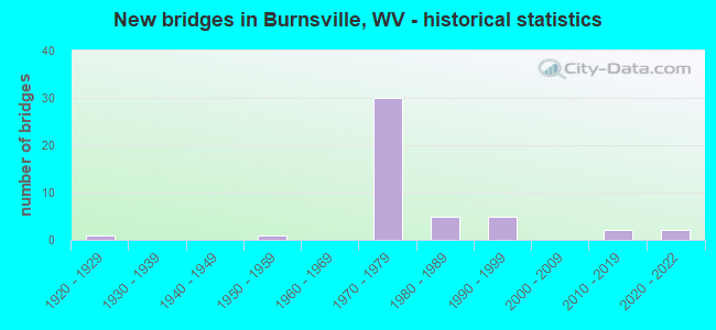
- New bridges - historical statistics
- 11920-1929
- 11950-1959
- 301970-1979
- 51980-1989
- 51990-1999
- 22010-2019
- 22020-2022
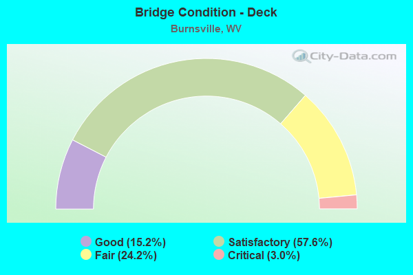
- Bridge Condition - Deck
- 15.2%Good
- 57.6%Satisfactory
- 24.2%Fair
- 3.0%Critical
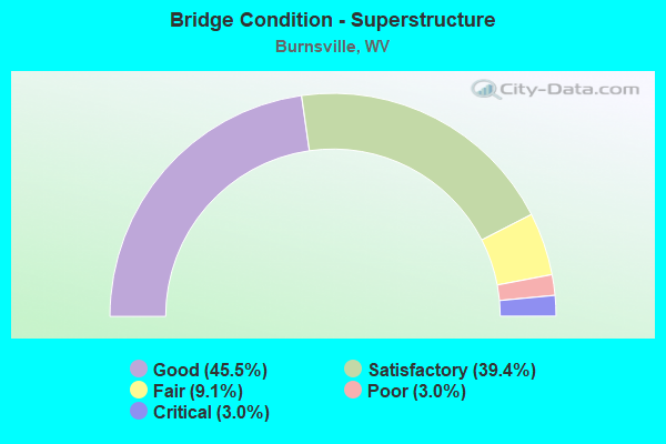
- Bridge Condition - Superstructure
- 45.5%Good
- 39.4%Satisfactory
- 9.1%Fair
- 3.0%Poor
- 3.0%Critical
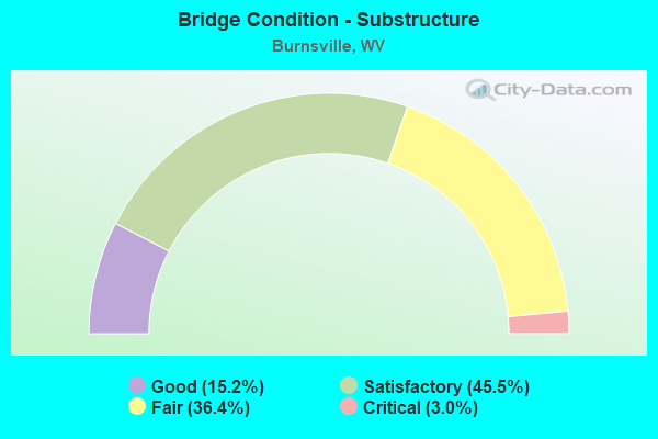
- Bridge Condition - Substructure
- 15.2%Good
- 45.5%Satisfactory
- 36.4%Fair
- 3.0%Critical
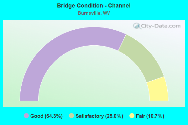
- Bridge Condition - Channel
- 64.3%Good
- 25.0%Satisfactory
- 10.7%Fair
Find on map >> Show street view
Structure Number: 4A004, Location: 1.52 MI N OF CO 2/1 (Lat: 38.868711, Lng: -80.717531), Route carried "on" structure: County highway 200, Year Built: 1957, Status: Posted for load, Structure Length: 2.78m (9.12ft), Average Daily Traffic: 55 (year 2018), Truck Traffic: 6%, Average Future Daily Traffic: 76 (year 2038), Features Intersected: COPEN RUN, Facility Carried by Structure: COUNTY ROUTE 2
Minimum Vertical Clearance: 30+ m (98+ ft), Kilometerpoint: 12.987, Lanes on structure: 1, Owner: State Highway Agency, Approaching Roadway Width: 6.7m (22.0ft), Skew: 4 degrees, Material/Design: Steel continuous, Design/Construction: Girder and Floorbeam System, Number Of Spans In Main Unit: 1, Number Of Approach Spans: 1, Length of Maximum Span: 13.4m (44.0ft), Curb or Sidewalk Widths: Left: 0.2m (0.7ft), Right: 0.2m (0.7ft), Curb-To-Curb Width: 3.7m (12.1ft), Out-to-Out Width: 4.0m (13.1ft)
Condition: Deck: Fair, Superstructure: Fair, Substructure: Fair, Channel: Good, Operating Rating: 49.9 metric tons, Method Used To Determine Operating Rating: Load Factor (LF), Inventory Rating: 29.9 metric tons, Method Used To Determine Inventory Rating: Load Factor (LF), Structural Evaluation: Somewhat better than minimum adequacy, Deck Geometry: Meets minimum limits, Waterway Adequacy: Equal to present desirable criteria, Approach Roadway Alignment: Equal to present minimum criteria, Bridge Posting: Required (Relationship of Operating Rating to Maximum Legal Load: 10.0 - 19.9% below), Length Of Structure Improvement: 3.96m (12.99ft), Designated Inspection Frequency: Every 24 months, Critical Feature Inspection Frequency: Every 24 months, Inspection Date: April 2020, Critical Feature Inspection Date: April 2020, Bridge Improvement Cost: $240,000, Roadway Improvement Cost: $125,000, Total Project Cost: $425,000 ( Estimate for 2020), Deck Structure Type: Wood or Timber
Find on map >> Show street view
Structure Number: 4A006, Location: 0.50 MI S CO 2 (Lat: 38.814361, Lng: -80.696481), Route carried "on" structure: County highway 205, Year Built: 1988, Status: Open, Structure Length: 1.16m (3.81ft), Average Daily Traffic: 33 (year 2015), Truck Traffic: 6%, Average Future Daily Traffic: 47 (year 2035), Design Load: HS 20, Features Intersected: RT FK OF SALTLICK CREEK, Facility Carried by Structure: COUNTY ROUTE 2/5
Minimum Vertical Clearance: 30+ m (98+ ft), Kilometerpoint: 2.124, Lanes on structure: 1, Owner: State Highway Agency, Approaching Roadway Width: 5.8m (19.0ft), Skew: 5 degrees, Material/Design: Steel, Design/Construction: Stringer/Multi-beam, Number Of Spans In Main Unit: 1, Length of Maximum Span: 11.1m (36.4ft), Curb-To-Curb Width: 4.3m (14.1ft), Out-to-Out Width: 4.3m (14.1ft)
Condition: Deck: Good, Superstructure: Good, Substructure: Satisfactory, Channel: Fair, Operating Rating: 47.2 metric tons, Method Used To Determine Operating Rating: Load Factor (LF), Inventory Rating: 28.1 metric tons, Method Used To Determine Inventory Rating: Load Factor (LF), Structural Evaluation: Equal to present minimum criteria, Deck Geometry: Equal to present minimum criteria, Waterway Adequacy: Equal to present desirable criteria, Approach Roadway Alignment: Somewhat better than minimum adequacy, Designated Inspection Frequency: Every 48 months, Inspection Date: January 2020, Deck Structure Type: Corrugated Steel, Wearing Surface/Protective System: Wearing Surface: Bituminous
Find on map >> Show street view
Structure Number: 4A009, Location: 0.01 MI W OF CO 2 (Lat: 38.831281, Lng: -80.669750), Route carried "on" structure: State highway 500, Year Built: 1988, Status: Open, Structure Length: 1.81m (5.94ft), Average Daily Traffic: 450 (year 2018), Truck Traffic: 6%, Average Future Daily Traffic: 600 (year 2038), Design Load: HS 20, Features Intersected: RIGHT FORK OF SALTLICK, Facility Carried by Structure: WV 5
Minimum Vertical Clearance: 30+ m (98+ ft), Kilometerpoint: 9.881, Lanes on structure: 2, Owner: State Highway Agency, Approaching Roadway Width: 7.6m (24.9ft), Skew: 4 degrees, Material/Design: Prestressed concrete, Design/Construction: Box Beam or Girders - Multiple, Number Of Spans In Main Unit: 1, Length of Maximum Span: 17.7m (58.1ft), Curb-To-Curb Width: 8.7m (28.5ft), Out-to-Out Width: 9.2m (30.2ft)
Condition: Deck: Fair, Superstructure: Poor, Substructure: Fair, Channel: Good, Operating Rating: 49.9 metric tons, Method Used To Determine Operating Rating: Load and Resistance Factor (LRFR), Inventory Rating: 38.1 metric tons, Method Used To Determine Inventory Rating: Load and Resistance Factor (LRFR), Structural Evaluation: Meets minimum limits, Deck Geometry: Somewhat better than minimum adequacy, Waterway Adequacy: Superior to present desirable criteria, Approach Roadway Alignment: Equal to present desirable criteria, Designated Inspection Frequency: Every 24 months, Inspection Date: Febuary 2021, Deck Structure Type: Other, Wearing Surface/Protective System: Wearing Surface: Bituminous, Deck Protection: Epoxy Coated Reinforcing
Find on map >> Show street view
Structure Number: 4A016, Location: 0.09 MI E OF CO 5/10 (Lat: 38.860519, Lng: -80.664039), Route carried "on" structure: State highway 500, Year Built: 1973, Status: Open, Structure Length: 6.62m (21.72ft), Average Daily Traffic: 3,404 (year 2015), Truck Traffic: 8%, Average Future Daily Traffic: 4,969 (year 2035), Design Load: HS 20, Features Intersected: LITTLE KANAWHA RIVER, Facility Carried by Structure: WV 5
Minimum Vertical Clearance: 30+ m (98+ ft), Kilometerpoint: 6.164, Lanes on structure: 2, Owner: State Highway Agency, Approaching Roadway Width: 14.0m (45.9ft), Skew: 2 degrees, Material/Design: Steel continuous, Design/Construction: Stringer/Multi-beam, Number Of Spans In Main Unit: 1, Number Of Approach Spans: 2, Length of Maximum Span: 24.7m (81.0ft), Curb or Sidewalk Widths: Left: 0.3m (1.0ft), Right: 0.3m (1.0ft), Curb-To-Curb Width: 12.9m (42.3ft), Out-to-Out Width: 14.2m (46.6ft)
Condition: Deck: Satisfactory, Superstructure: Good, Substructure: Satisfactory, Channel: Satisfactory, Operating Rating: 64.4 metric tons, Method Used To Determine Operating Rating: Load Factor (LF), Inventory Rating: 38.1 metric tons, Method Used To Determine Inventory Rating: Load Factor (LF), Structural Evaluation: Equal to present minimum criteria, Deck Geometry: Equal to present minimum criteria, Waterway Adequacy: Superior to present desirable criteria, Approach Roadway Alignment: Equal to present desirable criteria, Designated Inspection Frequency: Every 48 months, Underwater Inspection Frequency: Every 60 months, Inspection Date: November 2019, Underwater Inspection Date: June 2021, Deck Structure Type: Concrete Cast-file-Place
Find on map >> Show street view
Structure Number: 4A017, Location: 0.02 MI E I-79 (Lat: 38.857819, Lng: -80.659681), Route carried "on" structure: County highway 511, Year Built: 1973, Status: Open, Structure Length: 3.90m (12.80ft), Average Daily Traffic: 800 (year 2018), Truck Traffic: 8%, Average Future Daily Traffic: 840 (year 2038), Design Load: HS 20, Features Intersected: SALTLICK CREEK, Facility Carried by Structure: COUNTY ROUTE5/11
Minimum Vertical Clearance: 30+ m (98+ ft), Kilometerpoint: 0.257, Lanes on structure: 4, Owner: State Highway Agency, Approaching Roadway Width: 12.2m (40.0ft), Material/Design: Steel continuous, Design/Construction: Stringer/Multi-beam, Number Of Spans In Main Unit: 1, Number Of Approach Spans: 2, Length of Maximum Span: 14.0m (45.9ft), Curb or Sidewalk Widths: Left: 0.0m, Right: 1.6m (5.2ft), Curb-To-Curb Width: 19.3m (63.3ft), Out-to-Out Width: 21.9m (71.9ft)
Condition: Deck: Satisfactory, Superstructure: Satisfactory, Substructure: Satisfactory, Channel: Satisfactory, Operating Rating: 49.0 metric tons, Method Used To Determine Operating Rating: Load Factor (LF), Inventory Rating: 29.9 metric tons, Method Used To Determine Inventory Rating: Load Factor (LF), Structural Evaluation: Equal to present minimum criteria, Deck Geometry: Equal to present minimum criteria, Waterway Adequacy: Equal to present desirable criteria, Approach Roadway Alignment: Equal to present desirable criteria, Length Of Structure Improvement: 4.82m (15.81ft), Designated Inspection Frequency: Every 24 months, Inspection Date: December 2021, Bridge Improvement Cost: $250,000, Roadway Improvement Cost: $25,000, Total Project Cost: $350,000 ( Estimate for 2022), Deck Structure Type: Concrete Cast-file-Place
Find on map >> Show street view
Structure Number: 4A018, Location: 0.04 MI W CO 5/10 (Lat: 38.856550, Lng: -80.656489), Route carried "on" structure: County highway 511, Year Built: 1972, Status: Open, Structure Length: 4.91m (16.11ft), Average Daily Traffic: 886 (year 2015), Truck Traffic: 4%, Average Future Daily Traffic: 1,267 (year 2035), Design Load: HS 20+Mod, Features Intersected: LITTLE KANAWHA RIVER, Facility Carried by Structure: COUNTY ROUTE 5/11
Minimum Vertical Clearance: 30+ m (98+ ft), Kilometerpoint: 0.579, Lanes on structure: 2, Owner: State Highway Agency, Approaching Roadway Width: 12.2m (40.0ft), Skew: 2 degrees, Material/Design: Steel continuous, Design/Construction: Stringer/Multi-beam, Number Of Spans In Main Unit: 1, Number Of Approach Spans: 2, Length of Maximum Span: 18.6m (61.0ft), Curb or Sidewalk Widths: Left: 0.0m, Right: 1.5m (4.9ft), Curb-To-Curb Width: 11.9m (39.0ft), Out-to-Out Width: 14.4m (47.2ft)
Condition: Deck: Satisfactory, Superstructure: Good, Substructure: Satisfactory, Channel: Good, Operating Rating: 70.7 metric tons, Method Used To Determine Operating Rating: Load Factor (LF), Inventory Rating: 42.6 metric tons, Method Used To Determine Inventory Rating: Load Factor (LF), Structural Evaluation: Equal to present minimum criteria, Deck Geometry: Better than present minimum criteria, Waterway Adequacy: Superior to present desirable criteria, Approach Roadway Alignment: Equal to present desirable criteria, Length Of Structure Improvement: 1.52m (4.99ft), Designated Inspection Frequency: Every 48 months, Underwater Inspection Frequency: Every 60 months, Inspection Date: November 2019, Underwater Inspection Date: July 2020, Bridge Improvement Cost: $28,000, Roadway Improvement Cost: $15,000, Total Project Cost: $51,000 ( Estimate for 2020), Deck Structure Type: Concrete Cast-file-Place
Find on map >> Show street view
Structure Number: 4A02, Location: 0.08MI S OF CO 1 (Lat: 38.868739, Lng: -80.607069), Route carried "on" structure: County highway 103, Year Built: 1980, Status: Posted for load, Structure Length: 1.83m (6.00ft), Average Daily Traffic: 10 (year 2018), Truck Traffic: 6%, Average Future Daily Traffic: 15 (year 2038), Design Load: H 20, Features Intersected: OIL CREEK, Facility Carried by Structure: COUNTY ROUTE 1/3
Minimum Vertical Clearance: 30+ m (98+ ft), Kilometerpoint: 0.129, Lanes on structure: 1, Owner: State Highway Agency, Approaching Roadway Width: 4.3m (14.1ft), Skew: 2 degrees, Material/Design: Steel, Design/Construction: Stringer/Multi-beam, Number Of Spans In Main Unit: 1, Number Of Approach Spans: 1, Length of Maximum Span: 12.0m (39.4ft), Curb or Sidewalk Widths: Left: 0.2m (0.7ft), Right: 0.2m (0.7ft), Curb-To-Curb Width: 4.3m (14.1ft), Out-to-Out Width: 4.6m (15.1ft)
Condition: Deck: Fair, Superstructure: Good, Substructure: Fair, Channel: Fair, Operating Rating: 39.9 metric tons, Method Used To Determine Operating Rating: Load Factor (LF), Inventory Rating: 23.6 metric tons, Method Used To Determine Inventory Rating: Load Factor (LF), Structural Evaluation: Somewhat better than minimum adequacy, Deck Geometry: Equal to present minimum criteria, Waterway Adequacy: Equal to present minimum criteria, Approach Roadway Alignment: Equal to present minimum criteria, Bridge Posting: Required (Relationship of Operating Rating to Maximum Legal Load: 10.0 - 19.9% below), Length Of Structure Improvement: 2.44m (8.01ft), Designated Inspection Frequency: Every 24 months, Critical Feature Inspection Frequency: Every 24 months, Underwater Inspection Frequency: Every 60 months, Inspection Date: October 2020, Critical Feature Inspection Date: October 2020, Underwater Inspection Date: June 2021, Bridge Improvement Cost: $250,000, Roadway Improvement Cost: $100,000, Total Project Cost: $450,000 ( Estimate for 2020), Deck Structure Type: Wood or Timber
Find on map >> Show street view
Structure Number: 4A024, Location: 0.03 MI E OF CO 1 (Lat: 38.862919, Lng: -80.654800), Route carried "on" structure: County highway 510, Year Built: 1929, Status: Closed, Structure Length: 4.12m (13.52ft), Average Daily Traffic: 885 (year 2015), Truck Traffic: 6%, Average Future Daily Traffic: 1,267 (year 2035), Features Intersected: OIL CREEK, Facility Carried by Structure: COUNTY ROUTE 5/10
Minimum Vertical Clearance: 30+ m (98+ ft), Kilometerpoint: 1.078, Lanes on structure: 2, Owner: State Highway Agency, Approaching Roadway Width: 8.5m (27.9ft), Material/Design: Concrete, Design/Construction: Tee Beam, Number Of Spans In Main Unit: 1, Number Of Approach Spans: 2, Length of Maximum Span: 16.3m (53.5ft), Curb or Sidewalk Widths: Left: 0.1m (0.3ft), Right: 0.1m (0.3ft), Curb-To-Curb Width: 6.7m (22.0ft), Out-to-Out Width: 7.5m (24.6ft)
Condition: Deck: Critical, Superstructure: Critical, Substructure: Critical, Channel: Satisfactory, Deck Geometry: Meets minimum limits, Waterway Adequacy: Superior to present desirable criteria, Approach Roadway Alignment: Somewhat better than minimum adequacy, Bridge Posting: Required (Relationship of Operating Rating to Maximum Legal Load: 30.0 - 39.9% below), Length Of Structure Improvement: 4.57m (14.99ft), Designated Inspection Frequency: Every 24 months, Inspection Date: July 2021, Bridge Improvement Cost: $800,000, Roadway Improvement Cost: $200,000, Total Project Cost: $1,300,000 ( Estimate for 2021), Deck Structure Type: Concrete Cast-file-Place, Wearing Surface/Protective System: Wearing Surface: Bituminous
Find on map >> Show street view
Structure Number: 4A121, Location: 3.33 MI S OF CO RT 5/11 (Lat: 38.812239, Lng: -80.667311), Route carried "on" structure: Interstate 7900, Year Built: 1971, Status: Open, Structure Length: 9.64m (31.63ft), Average Daily Traffic: 9,500 (year 2018), Truck Traffic: 24%, Average Future Daily Traffic: 13,585 (year 2038), Design Load: HS 20+Mod, Features Intersected: Saltlick Ck A&O RR WV 5, Facility Carried by Structure: INTERSTATE 79 X
Minimum Vertical Clearance: 30+ m (98+ ft), Kilometerpoint: 121.586, Lanes on structure: 2, Lanes under structure: 2, Base Highway Network: Yes, Owner: State Highway Agency, Approaching Roadway Width: 14.0m (45.9ft), Skew: 1 degrees, Material/Design: Steel continuous, Design/Construction: Stringer/Multi-beam, Number Of Spans In Main Unit: 1, Number Of Approach Spans: 5, Length of Maximum Span: 19.5m (64.0ft), Curb-To-Curb Width: 12.3m (40.4ft), Out-to-Out Width: 13.6m (44.6ft)
Condition: Deck: Fair, Superstructure: Good, Substructure: Fair, Channel: Good, Operating Rating: 59.0 metric tons, Method Used To Determine Operating Rating: Load Factor (LF), Inventory Rating: 35.4 metric tons, Method Used To Determine Inventory Rating: Load Factor (LF), Structural Evaluation: Somewhat better than minimum adequacy, Deck Geometry: Better than present minimum criteria, Underclear: Equal to present desirable criteria, Waterway Adequacy: Superior to present desirable criteria, Approach Roadway Alignment: Equal to present desirable criteria, Designated Inspection Frequency: Every 24 months, Inspection Date: September 2021, Deck Structure Type: Concrete Cast-file-Place, Wearing Surface/Protective System: Wearing Surface: Latex Concrete
Find on map >> Show street view
Structure Number: 4A122, Location: 3.33 MI S OF CO RT 5/11 (Lat: 38.812311, Lng: -80.667550), Route carried "on" structure: Interstate 7900, Year Built: 1971, Status: Open, Structure Length: 10.80m (35.43ft), Average Daily Traffic: 9,500 (year 2018), Truck Traffic: 23%, Average Future Daily Traffic: 13,585 (year 2038), Design Load: HS 20+Mod, Features Intersected: Saltlick CK A&O RR, WV 5, Facility Carried by Structure: INTERSTATE I-79 SB
Minimum Vertical Clearance: 30+ m (98+ ft), Kilometerpoint: 121.586, Lanes on structure: 2, Lanes under structure: 2, Base Highway Network: Yes, Owner: State Highway Agency, Approaching Roadway Width: 14.0m (45.9ft), Skew: 1 degrees, Material/Design: Steel continuous, Design/Construction: Stringer/Multi-beam, Number Of Spans In Main Unit: 2, Number Of Approach Spans: 4, Length of Maximum Span: 19.4m (63.6ft), Curb-To-Curb Width: 12.3m (40.4ft), Out-to-Out Width: 13.6m (44.6ft)
Condition: Deck: Satisfactory, Superstructure: Good, Substructure: Fair, Channel: Good, Operating Rating: 54.4 metric tons, Method Used To Determine Operating Rating: Load Factor (LF), Inventory Rating: 32.7 metric tons, Method Used To Determine Inventory Rating: Load Factor (LF), Structural Evaluation: Somewhat better than minimum adequacy, Deck Geometry: Better than present minimum criteria, Underclear: Somewhat better than minimum adequacy, Waterway Adequacy: Superior to present desirable criteria, Approach Roadway Alignment: Equal to present desirable criteria, Designated Inspection Frequency: Every 24 months, Inspection Date: September 2021, Deck Structure Type: Concrete Cast-file-Place, Wearing Surface/Protective System: Wearing Surface: Latex Concrete
Find on map >> Show street view
Structure Number: 4A123, Location: 0.70 MI S OF CO RT 5/11 (Lat: 38.849261, Lng: -80.664889), Route carried "on" structure: Interstate 7900, Year Built: 1973, Status: Open, Structure Length: 10.00m (32.81ft), Average Daily Traffic: 9,500 (year 2018), Truck Traffic: 24%, Average Future Daily Traffic: 13,585 (year 2038), Design Load: HS 20+Mod, Features Intersected: SALTLICK CREEK & A&O R/R, Facility Carried by Structure: INTERSTATE RT 79 X
Minimum Vertical Clearance: 30+ m (98+ ft), Kilometerpoint: 125.819, Lanes on structure: 2, Base Highway Network: Yes, Owner: State Highway Agency, Approaching Roadway Width: 14.0m (45.9ft), Skew: 3 degrees, Material/Design: Steel continuous, Design/Construction: Stringer/Multi-beam, Number Of Spans In Main Unit: 2, Number Of Approach Spans: 2, Length of Maximum Span: 28.7m (94.2ft), Curb-To-Curb Width: 12.3m (40.4ft), Out-to-Out Width: 13.6m (44.6ft)
Condition: Deck: Satisfactory, Superstructure: Good, Substructure: Fair, Channel: Good, Operating Rating: 59.9 metric tons, Method Used To Determine Operating Rating: Load Factor (LF), Inventory Rating: 35.4 metric tons, Method Used To Determine Inventory Rating: Load Factor (LF), Structural Evaluation: Somewhat better than minimum adequacy, Deck Geometry: Better than present minimum criteria, Underclear: Better than present minimum criteria, Waterway Adequacy: Superior to present desirable criteria, Approach Roadway Alignment: Equal to present desirable criteria, Length Of Structure Improvement: 10.00m (32.81ft), Designated Inspection Frequency: Every 24 months, Inspection Date: August 2021, Bridge Improvement Cost: $200,000, Total Project Cost: $250,000 ( Estimate for 2021), Deck Structure Type: Concrete Cast-file-Place, Wearing Surface/Protective System: Wearing Surface: Latex Concrete
Find on map >> Show street view
Structure Number: 4A124, Location: 0.70 MI S OF CO 5/11 SLS (Lat: 38.849419, Lng: -80.665119), Route carried "on" structure: Interstate 7900, Year Built: 1973, Status: Open, Structure Length: 10.00m (32.81ft), Average Daily Traffic: 9,500 (year 2018), Truck Traffic: 24%, Average Future Daily Traffic: 13,600 (year 2038), Design Load: HS 20+Mod, Features Intersected: SALTLICK CREEK & A&O R/R, Facility Carried by Structure: I-79 X
Minimum Vertical Clearance: 30+ m (98+ ft), Kilometerpoint: 125.819, Lanes on structure: 2, Base Highway Network: Yes, Owner: State Highway Agency, Approaching Roadway Width: 14.0m (45.9ft), Skew: 3 degrees, Material/Design: Steel continuous, Design/Construction: Stringer/Multi-beam, Number Of Spans In Main Unit: 2, Number Of Approach Spans: 2, Length of Maximum Span: 28.7m (94.2ft), Curb-To-Curb Width: 12.3m (40.4ft), Out-to-Out Width: 13.6m (44.6ft)
Condition: Deck: Satisfactory, Superstructure: Good, Substructure: Fair, Channel: Good, Operating Rating: 58.0 metric tons, Method Used To Determine Operating Rating: Load Factor (LF), Inventory Rating: 34.5 metric tons, Method Used To Determine Inventory Rating: Load Factor (LF), Structural Evaluation: Somewhat better than minimum adequacy, Deck Geometry: Better than present minimum criteria, Underclear: Better than present minimum criteria, Waterway Adequacy: Superior to present desirable criteria, Approach Roadway Alignment: Equal to present desirable criteria, Length Of Structure Improvement: 10.00m (32.81ft), Designated Inspection Frequency: Every 24 months, Inspection Date: August 2021, Bridge Improvement Cost: $200,000, Total Project Cost: $250,000 ( Estimate for 2021), Deck Structure Type: Concrete Cast-file-Place, Wearing Surface/Protective System: Wearing Surface: Latex Concrete
Find on map >> Show street view
Structure Number: 4A125, Location: 11.86 MI N US 19 (Lat: 38.858400, Lng: -80.660589), Route carried "on" structure: Interstate 7900, Year Built: 1973, Status: Open, Structure Length: 4.69m (15.39ft), Average Daily Traffic: 9,600 (year 2018), Truck Traffic: 23%, Average Future Daily Traffic: 13,728 (year 2038), Design Load: HS 20+Mod, Features Intersected: Co 5/11, Facility Carried by Structure: I-79 N
Minimum Vertical Clearance: 30+ m (98+ ft), Kilometerpoint: 126.913, Lanes on structure: 2, Lanes under structure: 4, Base Highway Network: Yes, Owner: State Highway Agency, Approaching Roadway Width: 14.0m (45.9ft), Skew: 1 degrees, Material/Design: Steel, Design/Construction: Stringer/Multi-beam, Number Of Spans In Main Unit: 1, Number Of Approach Spans: 2, Length of Maximum Span: 23.3m (76.4ft), Curb-To-Curb Width: 12.3m (40.4ft), Out-to-Out Width: 13.6m (44.6ft)
Condition: Deck: Satisfactory, Superstructure: Fair, Substructure: Satisfactory, Operating Rating: 81.6 metric tons, Method Used To Determine Operating Rating: Load Factor (LF), Inventory Rating: 49.0 metric tons, Method Used To Determine Inventory Rating: Load Factor (LF), Structural Evaluation: Somewhat better than minimum adequacy, Deck Geometry: Better than present minimum criteria, Underclear: Equal to present minimum criteria, Approach Roadway Alignment: Equal to present desirable criteria, Length Of Structure Improvement: 4.69m (15.39ft), Designated Inspection Frequency: Every 24 months, Other Special Inspection Frequency: Every 24 months, Inspection Date: November 2021, Other Special Inspection Date: October 2021, Bridge Improvement Cost: $247,000, Roadway Improvement Cost: $10,000, Total Project Cost: $323,000 ( Estimate for 2022), Deck Structure Type: Concrete Cast-file-Place, Wearing Surface/Protective System: Wearing Surface: Latex Concrete
Find on map >> Show street view
Structure Number: 4A126, Location: 11.86 MI N US 19 (Lat: 38.858531, Lng: -80.660811), Route carried "on" structure: Interstate 7900, Year Built: 1973, Status: Open, Structure Length: 4.69m (15.39ft), Average Daily Traffic: 9,600 (year 2018), Truck Traffic: 24%, Average Future Daily Traffic: 13,728 (year 2038), Design Load: HS 20+Mod, Features Intersected: Co 5/11, Facility Carried by Structure: I-79 S
Minimum Vertical Clearance: 30+ m (98+ ft), Kilometerpoint: 126.913, Lanes on structure: 2, Lanes under structure: 4, Base Highway Network: Yes, Owner: State Highway Agency, Approaching Roadway Width: 14.0m (45.9ft), Skew: 11 degrees, Material/Design: Steel, Design/Construction: Stringer/Multi-beam, Number Of Spans In Main Unit: 1, Number Of Approach Spans: 2, Length of Maximum Span: 23.3m (76.4ft), Curb-To-Curb Width: 12.3m (40.4ft), Out-to-Out Width: 13.6m (44.6ft)
Condition: Deck: Satisfactory, Superstructure: Satisfactory, Substructure: Satisfactory, Operating Rating: 81.6 metric tons, Method Used To Determine Operating Rating: Load Factor (LF), Inventory Rating: 49.0 metric tons, Method Used To Determine Inventory Rating: Load Factor (LF), Structural Evaluation: Equal to present minimum criteria, Deck Geometry: Better than present minimum criteria, Underclear: Equal to present minimum criteria, Approach Roadway Alignment: Equal to present desirable criteria, Length Of Structure Improvement: 4.69m (15.39ft), Designated Inspection Frequency: Every 24 months, Inspection Date: November 2021, Bridge Improvement Cost: $247,000, Roadway Improvement Cost: $10,000, Total Project Cost: $323,000 ( Estimate for 2022), Deck Structure Type: Concrete Cast-file-Place, Wearing Surface/Protective System: Wearing Surface: Latex Concrete
Find on map >> Show street view
Structure Number: 4A127, Location: 0.22 MI N CO 5/11 (Lat: 38.860319, Lng: -80.657169), Route carried "on" structure: Interstate 7900, Year Built: 1973, Status: Open, Structure Length: 6.97m (22.87ft), Average Daily Traffic: 9,600 (year 2018), Truck Traffic: 23%, Average Future Daily Traffic: 13,728 (year 2038), Design Load: HS 20+Mod, Features Intersected: A&O RR, Main Street, Facility Carried by Structure: I-79
Minimum Vertical Clearance: 30+ m (98+ ft), Kilometerpoint: 127.267, Lanes on structure: 3, Lanes under structure: 2, Base Highway Network: Yes, Owner: State Highway Agency, Approaching Roadway Width: 14.0m (45.9ft), Skew: 2 degrees, Material/Design: Steel continuous, Design/Construction: Stringer/Multi-beam, Number Of Spans In Main Unit: 2, Number Of Approach Spans: 2, Length of Maximum Span: 19.5m (64.0ft), Curb or Sidewalk Widths: Left: 0.3m (1.0ft), Right: 0.3m (1.0ft), Curb-To-Curb Width: 17.7m (58.1ft), Out-to-Out Width: 18.9m (62.0ft)
Condition: Deck: Fair, Superstructure: Satisfactory, Substructure: Satisfactory, Operating Rating: 53.5 metric tons, Method Used To Determine Operating Rating: Load Factor (LF), Inventory Rating: 32.7 metric tons, Method Used To Determine Inventory Rating: Load Factor (LF), Structural Evaluation: Equal to present minimum criteria, Deck Geometry: Better than present minimum criteria, Underclear: Better than present minimum criteria, Approach Roadway Alignment: Equal to present desirable criteria, Length Of Structure Improvement: 6.98m (22.90ft), Designated Inspection Frequency: Every 24 months, Inspection Date: October 2021, Bridge Improvement Cost: $658,000, Roadway Improvement Cost: $10,000, Total Project Cost: $959,000 ( Estimate for 2021), Deck Structure Type: Concrete Cast-file-Place, Wearing Surface/Protective System: Wearing Surface: Latex Concrete
Find on map >> Show street view
Structure Number: 4A128, Location: 0.20 MI N OF CO 5/11 (Lat: 38.860481, Lng: -80.657311), Route carried "on" structure: Interstate 7900, Year Built: 1973, Status: Open, Structure Length: 6.33m (20.77ft), Average Daily Traffic: 9,600 (year 2018), Truck Traffic: 23%, Average Future Daily Traffic: 13,728 (year 2038), Design Load: HS 20+Mod, Features Intersected: A&O RR, Main Street, Facility Carried by Structure: I-79
Minimum Vertical Clearance: 30+ m (98+ ft), Kilometerpoint: 127.267, Lanes on structure: 2, Lanes under structure: 2, Base Highway Network: Yes, Owner: State Highway Agency, Approaching Roadway Width: 14.0m (45.9ft), Skew: 2 degrees, Material/Design: Steel continuous, Design/Construction: Stringer/Multi-beam, Number Of Spans In Main Unit: 1, Number Of Approach Spans: 3, Length of Maximum Span: 19.5m (64.0ft), Curb or Sidewalk Widths: Left: 0.3m (1.0ft), Right: 0.3m (1.0ft), Curb-To-Curb Width: 12.6m (41.3ft), Out-to-Out Width: 13.9m (45.6ft)
Condition: Deck: Fair, Superstructure: Satisfactory, Substructure: Satisfactory, Operating Rating: 53.5 metric tons, Method Used To Determine Operating Rating: Load Factor (LF), Inventory Rating: 31.7 metric tons, Method Used To Determine Inventory Rating: Load Factor (LF), Structural Evaluation: Equal to present minimum criteria, Deck Geometry: Better than present minimum criteria, Underclear: Equal to present desirable criteria, Approach Roadway Alignment: Equal to present desirable criteria, Length Of Structure Improvement: 6.34m (20.80ft), Designated Inspection Frequency: Every 24 months, Inspection Date: October 2021, Bridge Improvement Cost: $443,000, Roadway Improvement Cost: $10,000, Total Project Cost: $689,000 ( Estimate for 2021), Deck Structure Type: Concrete Cast-file-Place, Wearing Surface/Protective System: Wearing Surface: Latex Concrete
Find on map >> Show street view
Structure Number: 4A129, Location: 0.33 MI N OF CO 5/11 SLS (Lat: 38.861219, Lng: -80.655431), Route carried "on" structure: Interstate 7900, Year Built: 1973, Status: Open, Structure Length: 23.32m (76.51ft), Average Daily Traffic: 9,600 (year 2018), Truck Traffic: 23%, Average Future Daily Traffic: 13,728 (year 2038), Design Load: HS 20+Mod, Features Intersected: Co 5/10 & Ltl Kanawha Rv, Facility Carried by Structure: INTERSTATE 79 NBL
Minimum Vertical Clearance: 30+ m (98+ ft), Kilometerpoint: 127.331, Lanes on structure: 2, Lanes under structure: 2, Base Highway Network: Yes, Owner: State Highway Agency, Approaching Roadway Width: 14.0m (45.9ft), Skew: 4 degrees, Material/Design: Steel continuous, Design/Construction: Stringer/Multi-beam, Number Of Spans In Main Unit: 2, Number Of Approach Spans: 13, Length of Maximum Span: 25.0m (82.0ft), Curb or Sidewalk Widths: Left: 0.3m (1.0ft), Right: 0.3m (1.0ft), Curb-To-Curb Width: 14.3m (46.9ft), Out-to-Out Width: 15.5m (50.9ft)
Condition: Deck: Satisfactory, Superstructure: Satisfactory, Substructure: Fair, Channel: Good, Operating Rating: 57.1 metric tons, Method Used To Determine Operating Rating: Load Factor (LF), Inventory Rating: 34.5 metric tons, Method Used To Determine Inventory Rating: Load Factor (LF), Structural Evaluation: Somewhat better than minimum adequacy, Deck Geometry: Superior to present desirable criteria, Underclear: Better than present minimum criteria, Waterway Adequacy: Superior to present desirable criteria, Approach Roadway Alignment: Equal to present desirable criteria, Length Of Structure Improvement: 23.32m (76.51ft), Designated Inspection Frequency: Every 24 months, Underwater Inspection Frequency: Every 60 months, Inspection Date: October 2021, Underwater Inspection Date: July 2017, Bridge Improvement Cost: $1,660,000, Roadway Improvement Cost: $10,000, Total Project Cost: $2,211,000 ( Estimate for 2021), Deck Structure Type: Concrete Cast-file-Place, Wearing Surface/Protective System: Wearing Surface: Latex Concrete
Find on map >> Show street view
Structure Number: 4A13, Location: 0.33 MI N OF CO 5/11 SLS (Lat: 38.861500, Lng: -80.655439), Route carried "on" structure: Interstate 7900, Year Built: 1973, Status: Open, Structure Length: 24.30m (79.72ft), Average Daily Traffic: 9,600 (year 2018), Truck Traffic: 24%, Average Future Daily Traffic: 13,728 (year 2038), Design Load: HS 20+Mod, Features Intersected: Co 5/10 & Ltl Kanawha Rv, Facility Carried by Structure: INTERSTATE 79
Minimum Vertical Clearance: 30+ m (98+ ft), Kilometerpoint: 127.331, Lanes on structure: 2, Lanes under structure: 2, Base Highway Network: Yes, Owner: State Highway Agency, Approaching Roadway Width: 14.0m (45.9ft), Skew: 3 degrees, Material/Design: Steel continuous, Design/Construction: Stringer/Multi-beam, Number Of Spans In Main Unit: 2, Number Of Approach Spans: 14, Length of Maximum Span: 25.0m (82.0ft), Curb or Sidewalk Widths: Left: 0.3m (1.0ft), Right: 0.3m (1.0ft), Curb-To-Curb Width: 12.3m (40.4ft), Out-to-Out Width: 13.6m (44.6ft)
Condition: Deck: Satisfactory, Superstructure: Satisfactory, Substructure: Fair, Channel: Good, Operating Rating: 59.9 metric tons, Method Used To Determine Operating Rating: Load Factor (LF), Inventory Rating: 35.4 metric tons, Method Used To Determine Inventory Rating: Load Factor (LF), Structural Evaluation: Somewhat better than minimum adequacy, Deck Geometry: Better than present minimum criteria, Underclear: Better than present minimum criteria, Waterway Adequacy: Superior to present desirable criteria, Approach Roadway Alignment: Equal to present desirable criteria, Length Of Structure Improvement: 24.29m (79.69ft), Designated Inspection Frequency: Every 24 months, Underwater Inspection Frequency: Every 60 months, Inspection Date: October 2021, Underwater Inspection Date: July 2017, Bridge Improvement Cost: $1,500,000, Roadway Improvement Cost: $100,000, Total Project Cost: $1,800,000 ( Estimate for 2021), Deck Structure Type: Concrete Cast-file-Place, Wearing Surface/Protective System: Wearing Surface: Latex Concrete
Find on map >> Show street view
Structure Number: 4A131, Location: 0.58 MI N OF CO 5/11 (Lat: 38.864169, Lng: -80.650011), Route carried "on" structure: Interstate 7900, Year Built: 1973, Status: Open, Structure Length: 11.68m (38.32ft), Average Daily Traffic: 9,600 (year 2018), Truck Traffic: 24%, Average Future Daily Traffic: 13,730 (year 2038), Design Load: HS 20+Mod, Features Intersected: I-79, Facility Carried by Structure: I-79 NBL
Minimum Vertical Clearance: 30+ m (98+ ft), Kilometerpoint: 128.039, Lanes on structure: 2, Lanes under structure: 2, Base Highway Network: Yes, Owner: State Highway Agency, Approaching Roadway Width: 14.0m (45.9ft), Skew: 2 degrees, Material/Design: Steel continuous, Design/Construction: Stringer/Multi-beam, Number Of Spans In Main Unit: 2, Number Of Approach Spans: 3, Length of Maximum Span: 26.5m (86.9ft), Curb or Sidewalk Widths: Left: 0.3m (1.0ft), Right: 0.3m (1.0ft), Curb-To-Curb Width: 12.3m (40.4ft), Out-to-Out Width: 13.6m (44.6ft)
Condition: Deck: Fair, Superstructure: Satisfactory, Substructure: Fair, Channel: Good, Operating Rating: 54.4 metric tons, Method Used To Determine Operating Rating: Load Factor (LF), Inventory Rating: 32.7 metric tons, Method Used To Determine Inventory Rating: Load Factor (LF), Structural Evaluation: Somewhat better than minimum adequacy, Deck Geometry: Better than present minimum criteria, Underclear: Equal to present minimum criteria, Waterway Adequacy: Superior to present desirable criteria, Approach Roadway Alignment: Equal to present desirable criteria, Length Of Structure Improvement: 11.67m (38.29ft), Designated Inspection Frequency: Every 24 months, Inspection Date: October 2021, Bridge Improvement Cost: $350,000, Roadway Improvement Cost: $50,000, Total Project Cost: $500,000 ( Estimate for 2021), Deck Structure Type: Concrete Cast-file-Place, Wearing Surface/Protective System: Wearing Surface: Bituminous
Find on map >> Show street view
Structure Number: 4A132, Location: 0.58 MI N CO 5/11 SLS (Lat: 38.864411, Lng: -80.650061), Route carried "on" structure: Interstate 7900, Year Built: 1973, Status: Open, Structure Length: 11.65m (38.22ft), Average Daily Traffic: 9,600 (year 2018), Truck Traffic: 23%, Average Future Daily Traffic: 13,728 (year 2038), Design Load: HS 20+Mod, Features Intersected: I-79, Facility Carried by Structure: I-79
Minimum Vertical Clearance: 30+ m (98+ ft), Kilometerpoint: 128.039, Lanes on structure: 2, Lanes under structure: 2, Base Highway Network: Yes, Owner: State Highway Agency, Approaching Roadway Width: 14.0m (45.9ft), Skew: 3 degrees, Material/Design: Steel continuous, Design/Construction: Stringer/Multi-beam, Number Of Spans In Main Unit: 2, Number Of Approach Spans: 3, Length of Maximum Span: 26.5m (86.9ft), Curb or Sidewalk Widths: Left: 0.3m (1.0ft), Right: 0.3m (1.0ft), Curb-To-Curb Width: 12.3m (40.4ft), Out-to-Out Width: 13.6m (44.6ft)
Condition: Deck: Satisfactory, Superstructure: Fair, Substructure: Fair, Channel: Good, Operating Rating: 54.4 metric tons, Method Used To Determine Operating Rating: Load Factor (LF), Inventory Rating: 32.7 metric tons, Method Used To Determine Inventory Rating: Load Factor (LF), Structural Evaluation: Somewhat better than minimum adequacy, Deck Geometry: Better than present minimum criteria, Underclear: Somewhat better than minimum adequacy, Waterway Adequacy: Superior to present desirable criteria, Approach Roadway Alignment: Equal to present desirable criteria, Length Of Structure Improvement: 11.67m (38.29ft), Designated Inspection Frequency: Every 24 months, Inspection Date: October 2021, Bridge Improvement Cost: $350,000, Roadway Improvement Cost: $50,000, Total Project Cost: $500,000 ( Estimate for 2021), Deck Structure Type: Concrete Cast-file-Place, Wearing Surface/Protective System: Wearing Surface: Latex Concrete
Find on map >> Show street view
Structure Number: 4A14, Location: 0.30 MI E OF WV 5 F (Lat: 38.802750, Lng: -80.644100), Route carried "on" structure: County highway 305, Year Built: 1993, Status: Open, Structure Length: 4.42m (14.50ft), Average Daily Traffic: 10 (year 2018), Average Future Daily Traffic: 11 (year 2038), Design Load: HS 25 or greater, Features Intersected: SALTLICK CREEK, Facility Carried by Structure: COUNTY ROUTE 3/5
Minimum Vertical Clearance: 30+ m (98+ ft), Kilometerpoint: 0.483, Lanes on structure: 1, Owner: State Highway Agency, Approaching Roadway Width: 5.5m (18.0ft), Skew: 3 degrees, Material/Design: Prestressed concrete, Design/Construction: Box Beam or Girders - Multiple, Number Of Spans In Main Unit: 1, Number Of Approach Spans: 1, Length of Maximum Span: 28.6m (93.8ft), Curb-To-Curb Width: 4.5m (14.8ft), Out-to-Out Width: 4.6m (15.1ft)
Condition: Deck: Satisfactory, Superstructure: Satisfactory, Substructure: Satisfactory, Channel: Satisfactory, Operating Rating: 79.8 metric tons, Method Used To Determine Operating Rating: Load and Resistance Factor (LRFR), Inventory Rating: 61.7 metric tons, Method Used To Determine Inventory Rating: Load and Resistance Factor (LRFR), Structural Evaluation: Equal to present minimum criteria, Deck Geometry: Equal to present minimum criteria, Waterway Adequacy: Superior to present desirable criteria, Approach Roadway Alignment: Equal to present desirable criteria, Designated Inspection Frequency: Every 48 months, Inspection Date: July 2021, Deck Structure Type: Other, Wearing Surface/Protective System: Wearing Surface: Bituminous, Deck Protection: Epoxy Coated Reinforcing
Find on map >> Show street view
Structure Number: 4A143, Location: 0.02 MI S OF CO 1 (Lat: 38.862881, Lng: -80.635681), Route carried "on" structure: County highway 101, Year Built: 1989, Status: Open, Structure Length: 2.50m (8.20ft), Average Daily Traffic: 40 (year 2018), Average Future Daily Traffic: 42 (year 2038), Design Load: HS 20, Features Intersected: OIL CREEK, Facility Carried by Structure: COUNTY ROUTE 1/1
Minimum Vertical Clearance: 30+ m (98+ ft), Kilometerpoint: 0.032, Lanes on structure: 1, Owner: State Highway Agency, Approaching Roadway Width: 6.4m (21.0ft), Material/Design: Steel, Design/Construction: Stringer/Multi-beam, Number Of Spans In Main Unit: 1, Length of Maximum Span: 24.4m (80.1ft), Curb or Sidewalk Widths: Left: 0.2m (0.7ft), Right: 0.2m (0.7ft), Curb-To-Curb Width: 4.3m (14.1ft), Out-to-Out Width: 4.3m (14.1ft)
Condition: Deck: Fair, Superstructure: Satisfactory, Substructure: Satisfactory, Channel: Satisfactory, Operating Rating: 82.5 metric tons, Method Used To Determine Operating Rating: Load Factor (LF), Inventory Rating: 49.0 metric tons, Method Used To Determine Inventory Rating: Load Factor (LF), Structural Evaluation: Equal to present minimum criteria, Deck Geometry: Equal to present minimum criteria, Waterway Adequacy: Better than present minimum criteria, Approach Roadway Alignment: Equal to present desirable criteria, Designated Inspection Frequency: Every 24 months, Inspection Date: August 2021, Deck Structure Type: Wood or Timber
Find on map >> Show street view
Structure Number: 4A15, Location: 0.01 MI W CO 1/2 (Lat: 38.871981, Lng: -80.613219), Route carried "on" structure: County highway 100, Year Built: 1991, Status: Open, Structure Length: 0.71m (2.33ft), Average Daily Traffic: 300 (year 2018), Truck Traffic: 6%, Average Future Daily Traffic: 414 (year 2038), Design Load: HS 25 or greater, Features Intersected: POSEY RUN, Facility Carried by Structure: COUNTY ROUTE 1
Minimum Vertical Clearance: 30+ m (98+ ft), Kilometerpoint: 4.297, Lanes on structure: 2, Owner: State Highway Agency, Approaching Roadway Width: 4.9m (16.1ft), Skew: 1 degrees, Material/Design: Prestressed concrete, Design/Construction: Slab, Number Of Spans In Main Unit: 1, Length of Maximum Span: 6.7m (22.0ft), Curb-To-Curb Width: 6.8m (22.3ft), Out-to-Out Width: 7.3m (24.0ft)
Condition: Deck: Satisfactory, Superstructure: Satisfactory, Substructure: Satisfactory, Channel: Satisfactory, Operating Rating: 88.9 metric tons, Method Used To Determine Operating Rating: Load Factor (LF), Inventory Rating: 63.5 metric tons, Method Used To Determine Inventory Rating: Load Factor (LF), Structural Evaluation: Equal to present minimum criteria, Deck Geometry: Meets minimum limits, Waterway Adequacy: Equal to present minimum criteria, Approach Roadway Alignment: Equal to present desirable criteria, Designated Inspection Frequency: Every 48 months, Inspection Date: May 2021, Deck Structure Type: Other, Wearing Surface/Protective System: Wearing Surface: Bituminous, Deck Protection: Epoxy Coated Reinforcing
Find on map >> Show street view
Structure Number: 4A159, Location: 0.01 MI S JCT CO 2 (Lat: 38.818069, Lng: -80.685869), Route carried "on" structure: County highway 206, Year Built: 1997, Status: Open, Structure Length: 1.19m (3.90ft), Average Daily Traffic: 10 (year 2018), Truck Traffic: 10%, Average Future Daily Traffic: 12 (year 2038), Design Load: HS 25 or greater, Features Intersected: RT FK OF SALTLICK CREEK, Facility Carried by Structure: CO 2/6 SLS
Minimum Vertical Clearance: 30+ m (98+ ft), Kilometerpoint: 0.016, Lanes on structure: 2, Owner: State Highway Agency, Approaching Roadway Width: 4.9m (16.1ft), Skew: 3 degrees, Material/Design: Steel, Design/Construction: Stringer/Multi-beam, Number Of Spans In Main Unit: 1, Length of Maximum Span: 11.6m (38.1ft), Curb or Sidewalk Widths: Left: 0.2m (0.7ft), Right: 0.2m (0.7ft), Curb-To-Curb Width: 5.0m (16.4ft), Out-to-Out Width: 5.3m (17.4ft)
Condition: Deck: Satisfactory, Superstructure: Good, Substructure: Satisfactory, Channel: Good, Operating Rating: 88.9 metric tons, Method Used To Determine Operating Rating: Load Factor (LF), Inventory Rating: 52.6 metric tons, Method Used To Determine Inventory Rating: Load Factor (LF), Structural Evaluation: Equal to present minimum criteria, Deck Geometry: High priority of corrective action, Waterway Adequacy: Superior to present desirable criteria, Approach Roadway Alignment: Equal to present desirable criteria, Designated Inspection Frequency: Every 24 months, Inspection Date: November 2021, Deck Structure Type: Wood or Timber, Wearing Surface/Protective System: Wearing Surface: Bituminous
Find on map >> Show street view
Structure Number: 4A173, Location: 0.80 MI S OF CO 5/11 (Lat: 38.851731, Lng: -80.652981), Route carried "on" structure: County highway 3504, Year Built: 1970, Status: Open, Structure Length: 0.65m (2.13ft), Average Daily Traffic: 20 (year 2018), Truck Traffic: 8%, Average Future Daily Traffic: 21 (year 2038), Features Intersected: BROWNS RUN, Facility Carried by Structure: COUNTY ROUTE 35/4
Minimum Vertical Clearance: 30+ m (98+ ft), Kilometerpoint: 1.287, Lanes on structure: 1, Owner: State Highway Agency, Approaching Roadway Width: 4.6m (15.1ft), Skew: 4 degrees, Material/Design: Steel, Design/Construction: Culvert, Number Of Spans In Main Unit: 1, Length of Maximum Span: 6.5m (21.3ft)
Condition: Channel: Fair, Culverts: Fair, Operating Rating: 71.7 metric tons, Method Used To Determine Operating Rating: Field evaluation and documented engineering judgment, Inventory Rating: 32.7 metric tons, Method Used To Determine Inventory Rating: Field evaluation and documented engineering judgment, Structural Evaluation: Somewhat better than minimum adequacy, Waterway Adequacy: Meets minimum limits, Approach Roadway Alignment: Better than present minimum criteria, Length Of Structure Improvement: 1.28m (4.20ft), Designated Inspection Frequency: Every 24 months, Inspection Date: July 2021, Bridge Improvement Cost: $160,000, Roadway Improvement Cost: $150,000, Total Project Cost: $310,000 ( Estimate for 2021)
Find on map >> Show street view
Structure Number: 4A191, Location: 0.01 MI E OF CO 1/4 (Lat: 38.871039, Lng: -80.593219), Route carried "on" structure: County highway 1, Year Built: 2018, Status: Open, Structure Length: 3.16m (10.37ft), Average Daily Traffic: 200 (year 2018), Truck Traffic: 6%, Average Future Daily Traffic: 300 (year 2038), Design Load: Greater than HL93, Features Intersected: OIL CREEK
Minimum Vertical Clearance: 30+ m (98+ ft), Kilometerpoint: 6.470, Lanes on structure: 2, Owner: State Highway Agency, Approaching Roadway Width: 7.9m (25.9ft), Material/Design: Prestressed concrete, Design/Construction: Box Beam or Girders - Single/Spread, Number Of Spans In Main Unit: 1, Length of Maximum Span: 0.0m, Curb-To-Curb Width: 7.3m (24.0ft), Out-to-Out Width: 7.5m (24.6ft)
Condition: Deck: Good, Superstructure: Good, Substructure: Good, Channel: Good, Operating Rating: 80.7 metric tons, Method Used To Determine Operating Rating: Load and Resistance Factor (LRFR), Inventory Rating: 61.7 metric tons, Method Used To Determine Inventory Rating: Load and Resistance Factor (LRFR), Structural Evaluation: Better than present minimum criteria, Deck Geometry: Somewhat better than minimum adequacy, Waterway Adequacy: Equal to present desirable criteria, Approach Roadway Alignment: Better than present minimum criteria, Designated Inspection Frequency: Every 48 months, Inspection Date: Febuary 2021, Deck Structure Type: Concrete Precast Panels, Wearing Surface/Protective System: Wearing Surface: Bituminous, Membrane: Preformed Fabric, Deck Protection: Epoxy Coated Reinforcing
Find on map >> Show street view
Structure Number: 4A195, Location: 0.02 MI S JCT CO 1/ (SLS) (Lat: 38.863511, Lng: -80.648319), Route carried "on" structure: County highway 107, Year Built: 2019, Status: Open, Structure Length: 2.76m (9.06ft), Average Daily Traffic: 50 (year 2018), Truck Traffic: 7%, Average Future Daily Traffic: 53 (year 2038), Design Load: HL 93, Features Intersected: OIL CREEK, Facility Carried by Structure: COUNTY 1/7
Minimum Vertical Clearance: 30+ m (98+ ft), Kilometerpoint: 0.032, Lanes on structure: 2, Owner: State Highway Agency, Approaching Roadway Width: 7.9m (25.9ft), Material/Design: Prestressed concrete, Design/Construction: Box Beam or Girders - Multiple, Number Of Spans In Main Unit: 1, Length of Maximum Span: 26.4m (86.6ft), Curb-To-Curb Width: 7.3m (24.0ft), Out-to-Out Width: 7.5m (24.6ft)
Condition: Deck: Good, Superstructure: Good, Substructure: Good, Channel: Good, Operating Rating: 63.5 metric tons, Method Used To Determine Operating Rating: Load and Resistance Factor (LRFR), Inventory Rating: 49.9 metric tons, Method Used To Determine Inventory Rating: Load and Resistance Factor (LRFR), Structural Evaluation: Better than present minimum criteria, Deck Geometry: Equal to present minimum criteria, Waterway Adequacy: Equal to present desirable criteria, Approach Roadway Alignment: Equal to present desirable criteria, Designated Inspection Frequency: Every 48 months, Inspection Date: September 2021, Deck Structure Type: Concrete Precast Panels, Wearing Surface/Protective System: Wearing Surface: Bituminous, Membrane: Preformed Fabric, Deck Protection: Epoxy Coated Reinforcing
Find on map >> Show street view
Structure Number: 4A196, Location: 0.12 MI S WV 5 F (Lat: 38.862750, Lng: -80.699611), Route carried "on" structure: County highway 352, Year Built: 2020, Status: Open, Structure Length: 5.12m (16.80ft), Average Daily Traffic: 55 (year 2015), Average Future Daily Traffic: 80 (year 2035), Design Load: HL 93, Features Intersected: LITTLE KANAWHA RIVER, Facility Carried by Structure: C0 35/2 SLS
Minimum Vertical Clearance: 30+ m (98+ ft), Kilometerpoint: 4.973, Lanes on structure: 1, Owner: State Highway Agency, Approaching Roadway Width: 4.9m (16.1ft), Material/Design: Steel, Design/Construction: Stringer/Multi-beam, Number Of Spans In Main Unit: 1, Length of Maximum Span: 50.1m (164.4ft), Curb-To-Curb Width: 4.6m (15.1ft), Out-to-Out Width: 5.3m (17.4ft)
Condition: Deck: Good, Superstructure: Good, Substructure: Good, Channel: Good, Operating Rating: 38.1 metric tons, Method Used To Determine Operating Rating: Load and Resistance Factor (LRFR), Inventory Rating: 29.0 metric tons, Method Used To Determine Inventory Rating: Load and Resistance Factor (LRFR), Structural Evaluation: Better than present minimum criteria, Deck Geometry: Better than present minimum criteria, Waterway Adequacy: Equal to present desirable criteria, Approach Roadway Alignment: Meets minimum limits, Designated Inspection Frequency: Every 24 months, Inspection Date: September 2020, Deck Structure Type: Concrete Cast-file-Place, Wearing Surface/Protective System: Deck Protection: Epoxy Coated Reinforcing
Find on map >> Show street view
Structure Number: 4A197, Location: 0.29 MI E OF CO 2/6 (Lat: 38.819211, Lng: -80.681100), Route carried "on" structure: County highway 200, Year Built: 2020, Status: Open, Structure Length: 2.62m (8.60ft), Average Daily Traffic: 407 (year 2015), Truck Traffic: 6%, Average Future Daily Traffic: 582 (year 2035), Design Load: HL 93, Features Intersected: RIGHT FORK OF SALT LICK, Facility Carried by Structure: COUNTY ROUTE 2
Minimum Vertical Clearance: 30+ m (98+ ft), Kilometerpoint: 2.189, Lanes on structure: 2, Owner: State Highway Agency, Approaching Roadway Width: 8.2m (26.9ft), Skew: 4 degrees, Material/Design: Prestressed concrete, Design/Construction: Box Beam or Girders - Multiple, Number Of Spans In Main Unit: 1, Length of Maximum Span: 24.4m (80.1ft), Curb-To-Curb Width: 8.2m (26.9ft), Out-to-Out Width: 8.4m (27.6ft)
Condition: Deck: Good, Superstructure: Good, Substructure: Good, Channel: Good, Operating Rating: 74.4 metric tons, Method Used To Determine Operating Rating: Load and Resistance Factor (LRFR), Inventory Rating: 57.1 metric tons, Method Used To Determine Inventory Rating: Load and Resistance Factor (LRFR), Structural Evaluation: Better than present minimum criteria, Deck Geometry: Somewhat better than minimum adequacy, Waterway Adequacy: Equal to present desirable criteria, Approach Roadway Alignment: Somewhat better than minimum adequacy, Designated Inspection Frequency: Every 24 months, Inspection Date: August 2020, Deck Structure Type: Concrete Precast Panels, Wearing Surface/Protective System: Wearing Surface: Bituminous, Membrane: Other, Deck Protection: Epoxy Coated Reinforcing
Find on map >> Show street view
Structure Number: 4A903, Location: 0.02 MI N OF CO 5/11 (Lat: 38.857489, Lng: -80.658189), Route carried "on" structure: City street N0215, Year Built: 1988, Status: Open, Structure Length: 2.61m (8.56ft), Average Daily Traffic: 150 (year 2015), Truck Traffic: 6%, Average Future Daily Traffic: 207 (year 2035), Design Load: HS 25 or greater, Features Intersected: SALTLICK CREEK, Facility Carried by Structure: CHURCH STREET
Minimum Vertical Clearance: 30+ m (98+ ft), Kilometerpoint: 0.032, Lanes on structure: 2, Owner: City or Municipal Highway Agency, Approaching Roadway Width: 6.7m (22.0ft), Material/Design: Prestressed concrete, Design/Construction: Box Beam or Girders - Multiple, Number Of Spans In Main Unit: 1, Length of Maximum Span: 25.0m (82.0ft), Curb or Sidewalk Widths: Left: 0.0m, Right: 1.2m (3.9ft), Curb-To-Curb Width: 5.7m (18.7ft), Out-to-Out Width: 7.4m (24.3ft)
Condition: Deck: Satisfactory, Superstructure: Satisfactory, Substructure: Fair, Channel: Satisfactory, Operating Rating: 54.4 metric tons, Method Used To Determine Operating Rating: Load and Resistance Factor (LRFR), Inventory Rating: 41.7 metric tons, Method Used To Determine Inventory Rating: Load and Resistance Factor (LRFR), Structural Evaluation: Somewhat better than minimum adequacy, Deck Geometry: High priority of corrective action, Waterway Adequacy: Superior to present desirable criteria, Approach Roadway Alignment: Equal to present desirable criteria, Designated Inspection Frequency: Every 24 months, Inspection Date: April 2021, Deck Structure Type: Other, Wearing Surface/Protective System: Wearing Surface: Bituminous, Deck Protection: Epoxy Coated Reinforcing
Find on map >> Show street view
Structure Number: 11A091, Location: 0.01 MI S OF CO 36/2 (Lat: 38.910139, Lng: -80.665600), Route carried "on" structure: County highway 4010, Year Built: 1994, Status: Open, Structure Length: 0.90m (2.95ft), Average Daily Traffic: 10 (year 2018), Average Future Daily Traffic: 12 (year 2038), Design Load: HS 25 or greater, Features Intersected: HEATERS FORK, Facility Carried by Structure: COUNTY ROUTE 40/10
Minimum Vertical Clearance: 30+ m (98+ ft), Kilometerpoint: 2.511, Lanes on structure: 1, Owner: State Highway Agency, Approaching Roadway Width: 4.9m (16.1ft), Skew: 3 degrees, Material/Design: Steel, Design/Construction: Stringer/Multi-beam, Number Of Spans In Main Unit: 1, Length of Maximum Span: 8.7m (28.5ft), Curb or Sidewalk Widths: Left: 0.2m (0.7ft), Right: 0.2m (0.7ft), Curb-To-Curb Width: 4.2m (13.8ft), Out-to-Out Width: 4.2m (13.8ft)
Condition: Deck: Satisfactory, Superstructure: Good, Substructure: Satisfactory, Channel: Good, Operating Rating: 85.3 metric tons, Method Used To Determine Operating Rating: Load Factor (LF), Inventory Rating: 51.7 metric tons, Method Used To Determine Inventory Rating: Load Factor (LF), Structural Evaluation: Equal to present minimum criteria, Deck Geometry: Somewhat better than minimum adequacy, Waterway Adequacy: Better than present minimum criteria, Approach Roadway Alignment: Meets minimum limits, Designated Inspection Frequency: Every 48 months, Inspection Date: October 2020, Deck Structure Type: Wood or Timber
Find on map >> Show street view
Structure Number: 11A105, Location: 4.43 MI N CO 5/11 (Lat: 38.903500, Lng: -80.610119), Route carried "on" structure: Interstate 7900, Year Built: 1972, Status: Open, Structure Length: 3.58m (11.75ft), Average Daily Traffic: 9,100 (year 2018), Truck Traffic: 22%, Average Future Daily Traffic: 13,013 (year 2038), Design Load: HS 20+Mod, Features Intersected: Co 36, Facility Carried by Structure: I-79
Minimum Vertical Clearance: 30+ m (98+ ft), Kilometerpoint: 134.074, Lanes on structure: 2, Lanes under structure: 2, Base Highway Network: Yes, Owner: State Highway Agency, Approaching Roadway Width: 12.8m (42.0ft), Skew: 11 degrees, Material/Design: Steel continuous, Design/Construction: Stringer/Multi-beam, Number Of Spans In Main Unit: 1, Number Of Approach Spans: 2, Length of Maximum Span: 14.9m (48.9ft), Curb-To-Curb Width: 12.3m (40.4ft), Out-to-Out Width: 13.6m (44.6ft)
Condition: Deck: Satisfactory, Superstructure: Satisfactory, Substructure: Satisfactory, Operating Rating: 56.2 metric tons, Method Used To Determine Operating Rating: Load Factor (LF), Inventory Rating: 33.6 metric tons, Method Used To Determine Inventory Rating: Load Factor (LF), Structural Evaluation: Equal to present minimum criteria, Deck Geometry: Better than present minimum criteria, Underclear: Meets minimum limits, Approach Roadway Alignment: Equal to present desirable criteria, Length Of Structure Improvement: 3.58m (11.75ft), Designated Inspection Frequency: Every 24 months, Inspection Date: November 2021, Bridge Improvement Cost: $300,000, Total Project Cost: $350,000 ( Estimate for 2021), Deck Structure Type: Concrete Cast-file-Place, Wearing Surface/Protective System: Wearing Surface: Latex Concrete
Find on map >> Show street view
Structure Number: 11A106, Location: 4.43 MI N CO 5/11 (Lat: 38.903700, Lng: -80.610089), Route carried "on" structure: Interstate 7900, Year Built: 1972, Status: Open, Structure Length: 3.57m (11.71ft), Average Daily Traffic: 9,100 (year 2018), Truck Traffic: 22%, Average Future Daily Traffic: 13,013 (year 2038), Design Load: HS 20+Mod, Features Intersected: Co 36, Facility Carried by Structure: I-79 S
Minimum Vertical Clearance: 30+ m (98+ ft), Kilometerpoint: 134.074, Lanes on structure: 2, Lanes under structure: 2, Base Highway Network: Yes, Owner: State Highway Agency, Approaching Roadway Width: 12.8m (42.0ft), Skew: 1 degrees, Material/Design: Steel continuous, Design/Construction: Stringer/Multi-beam, Number Of Spans In Main Unit: 1, Number Of Approach Spans: 2, Length of Maximum Span: 14.9m (48.9ft), Curb-To-Curb Width: 12.3m (40.4ft), Out-to-Out Width: 13.6m (44.6ft)
Condition: Deck: Satisfactory, Superstructure: Satisfactory, Substructure: Satisfactory, Operating Rating: 59.0 metric tons, Method Used To Determine Operating Rating: Load Factor (LF), Inventory Rating: 35.4 metric tons, Method Used To Determine Inventory Rating: Load Factor (LF), Structural Evaluation: Equal to present minimum criteria, Deck Geometry: Better than present minimum criteria, Underclear: Meets minimum limits, Approach Roadway Alignment: Equal to present desirable criteria, Length Of Structure Improvement: 3.58m (11.75ft), Designated Inspection Frequency: Every 24 months, Inspection Date: November 2021, Bridge Improvement Cost: $300,000, Total Project Cost: $350,000 ( Estimate for 2021), Deck Structure Type: Concrete Cast-file-Place, Wearing Surface/Protective System: Wearing Surface: Latex Concrete
Find on map >> Show street view
Structure Number: 11A117, Location: 0.06 S OF CO RT 36 SLS (Lat: 38.919111, Lng: -80.671661), Route carried "on" structure: County highway 3602, Year Built: 1991, Status: Open, Structure Length: 1.29m (4.23ft), Average Daily Traffic: 44 (year 2015), Average Future Daily Traffic: 53 (year 2035), Design Load: HS 25 or greater, Features Intersected: ROCKY FORK, Facility Carried by Structure: COUNTY RT 36/2 SLS
Minimum Vertical Clearance: 30+ m (98+ ft), Kilometerpoint: 0.097, Lanes on structure: 1, Owner: State Highway Agency, Approaching Roadway Width: 5.5m (18.0ft), Skew: 1 degrees, Material/Design: Steel, Design/Construction: Stringer/Multi-beam, Number Of Spans In Main Unit: 1, Length of Maximum Span: 11.9m (39.0ft), Curb or Sidewalk Widths: Left: 0.1m (0.3ft), Right: 0.1m (0.3ft), Curb-To-Curb Width: 4.4m (14.4ft), Out-to-Out Width: 4.7m (15.4ft)
Condition: Deck: Satisfactory, Superstructure: Good, Substructure: Good, Channel: Good, Operating Rating: 77.1 metric tons, Method Used To Determine Operating Rating: Load Factor (LF), Inventory Rating: 46.3 metric tons, Method Used To Determine Inventory Rating: Load Factor (LF), Structural Evaluation: Better than present minimum criteria, Deck Geometry: Equal to present minimum criteria, Waterway Adequacy: Better than present minimum criteria, Approach Roadway Alignment: Equal to present desirable criteria, Designated Inspection Frequency: Every 48 months, Inspection Date: September 2019, Deck Structure Type: Wood or Timber
Find on map >> Show street view
Structure Number: 4A121, Location: 3.33 MI S OF CO RT 5/11 (Lat: 38.812239, Lng: -80.667311), Route carried "under" structure: State highway 500, Year Built: 1971, Structure Length: 0. m, Average Daily Traffic: 550 (year 0006), Truck Traffic: 8%, Features Intersected: Saltlick Ck A&O RR WV 5, Facility Carried by Structure: INTERSTATE 79 X
Minimum Vertical Clearance: 5.89m (19.32ft), Kilometerpoint: 12.505, Lanes on structure: 2, Lanes under structure: 2, Length of Maximum Span: 19.5m (64.0ft)
Find on map >> Show street view
Structure Number: 4A122, Location: 3.33 MI S OF CO RT 5/11 (Lat: 38.812311, Lng: -80.667550), Route carried "under" structure: State highway 500, Year Built: 1971, Structure Length: 0. m, Average Daily Traffic: 550 (year 0006), Truck Traffic: 8%, Features Intersected: Saltlick CK A&O RR, WV 5, Facility Carried by Structure: INTERSTATE I-79 SB
Minimum Vertical Clearance: 6.35m (20.83ft), Kilometerpoint: 12.505, Lanes on structure: 2, Lanes under structure: 2, Length of Maximum Span: 19.4m (63.6ft)
Find on map >> Show street view
Structure Number: 4A125, Location: 11.86 MI N US 19 (Lat: 38.858400, Lng: -80.660589), Route carried "under" structure: County highway 511, Year Built: 1973, Structure Length: 0. m, Average Daily Traffic: 800 (year 0009), Truck Traffic: 10%, Features Intersected: Co 5/11, Facility Carried by Structure: I-79 N
Minimum Vertical Clearance: 4.98m (16.34ft), Kilometerpoint: 0.161, Lanes on structure: 2, Lanes under structure: 4, Length of Maximum Span: 23.3m (76.4ft)
Find on map >> Show street view
Structure Number: 4A126, Location: 11.86 MI N US 19 (Lat: 38.858531, Lng: -80.660811), Route carried "under" structure: County highway 511, Year Built: 1973, Structure Length: 0. m, Average Daily Traffic: 800 (year 0009), Truck Traffic: 10%, Features Intersected: Co 5/11, Facility Carried by Structure: I-79 S
Minimum Vertical Clearance: 5.26m (17.26ft), Kilometerpoint: 0.145, Lanes on structure: 2, Lanes under structure: 4, Length of Maximum Span: 23.3m (76.4ft)
Find on map >> Show street view
Structure Number: 4A127, Location: 0.22 MI N CO 5/11 (Lat: 38.860319, Lng: -80.657169), Route carried "under" structure: City street , Year Built: 1973, Structure Length: 0. m, Average Daily Traffic: 50 (year 0009), Features Intersected: A&O RR, Main Street, Facility Carried by Structure: I-79
Minimum Vertical Clearance: 7.16m (23.49ft), Kilometerpoint: 0.000, Lanes on structure: 3, Lanes under structure: 2, Length of Maximum Span: 19.5m (64.0ft)
Find on map >> Show street view
Structure Number: 4A128, Location: 0.20 MI N OF CO 5/11 (Lat: 38.860481, Lng: -80.657311), Route carried "under" structure: City street , Year Built: 1973, Structure Length: 0. m, Average Daily Traffic: 50 (year 0009), Features Intersected: A&O RR, Main Street, Facility Carried by Structure: I-79
Minimum Vertical Clearance: 7.16m (23.49ft), Kilometerpoint: 0.000, Lanes on structure: 2, Lanes under structure: 2, Length of Maximum Span: 19.5m (64.0ft)
Find on map >> Show street view
Structure Number: 4A129, Location: 0.33 MI N OF CO 5/11 SLS (Lat: 38.861219, Lng: -80.655431), Route carried "under" structure: County highway 510, Year Built: 1973, Structure Length: 0. m, Average Daily Traffic: 800 (year 0009), Truck Traffic: 10%, Features Intersected: Co 5/10 & Ltl Kanawha Rv, Facility Carried by Structure: INTERSTATE 79 NBL
Minimum Vertical Clearance: 4.95m (16.24ft), Kilometerpoint: 1.127, Lanes on structure: 2, Lanes under structure: 2, Length of Maximum Span: 25.0m (82.0ft)
Find on map >> Show street view
Structure Number: 4A13, Location: 0.33 MI N OF CO 5/11 SLS (Lat: 38.861500, Lng: -80.655439), Route carried "under" structure: County highway 510, Year Built: 1973, Structure Length: 0. m, Average Daily Traffic: 800 (year 0009), Truck Traffic: 10%, Features Intersected: Co 5/10 & Ltl Kanawha Rv, Facility Carried by Structure: INTERSTATE 79
Minimum Vertical Clearance: 4.95m (16.24ft), Kilometerpoint: 1.110, Lanes on structure: 2, Lanes under structure: 2, Length of Maximum Span: 25.0m (82.0ft)
Find on map >> Show street view
Structure Number: 4A131, Location: 0.58 MI N OF CO 5/11 (Lat: 38.864169, Lng: -80.650011), Route carried "under" structure: County highway 100, Year Built: 1973, Structure Length: 0. m, Average Daily Traffic: 600 (year 0009), Truck Traffic: 10%, Features Intersected: I-79, Facility Carried by Structure: I-79 NBL
Minimum Vertical Clearance: 12.93m (42.42ft), Kilometerpoint: 0.499, Lanes on structure: 2, Lanes under structure: 2, Length of Maximum Span: 26.5m (86.9ft)
Find on map >> Show street view
Structure Number: 4A132, Location: 0.58 MI N CO 5/11 SLS (Lat: 38.864411, Lng: -80.650061), Route carried "under" structure: County highway 100, Year Built: 1973, Structure Length: 0. m, Average Daily Traffic: 600 (year 0009), Truck Traffic: 10%, Features Intersected: I-79, Facility Carried by Structure: I-79
Minimum Vertical Clearance: 12.62m (41.40ft), Kilometerpoint: 0.483, Lanes on structure: 2, Lanes under structure: 2, Length of Maximum Span: 26.5m (86.9ft)
Find on map >> Show street view
Structure Number: 11A105, Location: 4.43 MI N CO 5/11 (Lat: 38.903500, Lng: -80.610119), Route carried "under" structure: County highway 3600, Year Built: 1972, Structure Length: 0. m, Average Daily Traffic: 20 (year 0009), Features Intersected: Co 36, Facility Carried by Structure: I-79
Minimum Vertical Clearance: 4.67m (15.32ft), Kilometerpoint: 7.258, Lanes on structure: 2, Lanes under structure: 2, Length of Maximum Span: 14.9m (48.9ft)
Find on map >> Show street view
Structure Number: 11A106, Location: 4.43 MI N CO 5/11 (Lat: 38.903700, Lng: -80.610089), Route carried "under" structure: County highway 3600, Year Built: 1972, Structure Length: 0. m, Average Daily Traffic: 20 (year 0009), Features Intersected: Co 36, Facility Carried by Structure: I-79 S
Minimum Vertical Clearance: 4.67m (15.32ft), Kilometerpoint: 7.258, Lanes on structure: 2, Lanes under structure: 2, Length of Maximum Span: 14.9m (48.9ft)