Bridge Statistics for Burbank, California (CA)
Condition, Traffic, Stress, Structural Evaluation, Project Costs
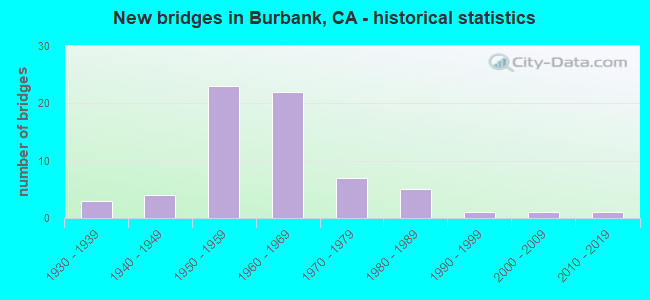
- New bridges - historical statistics
- 31930-1939
- 41940-1949
- 231950-1959
- 221960-1969
- 71970-1979
- 51980-1989
- 11990-1999
- 12000-2009
- 12010-2019
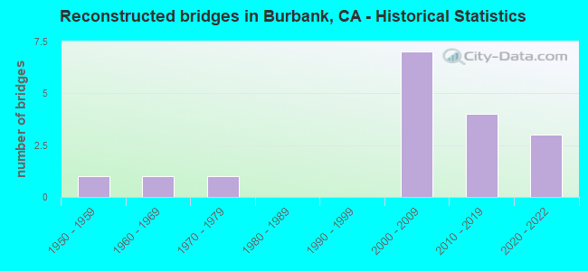
- Reconstructed bridges - Historical Statistics
- 11950-1959
- 11960-1969
- 11970-1979
- 01980-1989
- 01990-1999
- 72000-2009
- 42010-2019
- 32020-2022
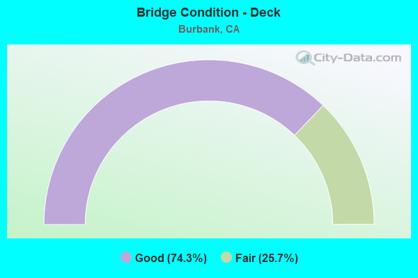
- Bridge Condition - Deck
- 74.3%Good
- 25.7%Fair
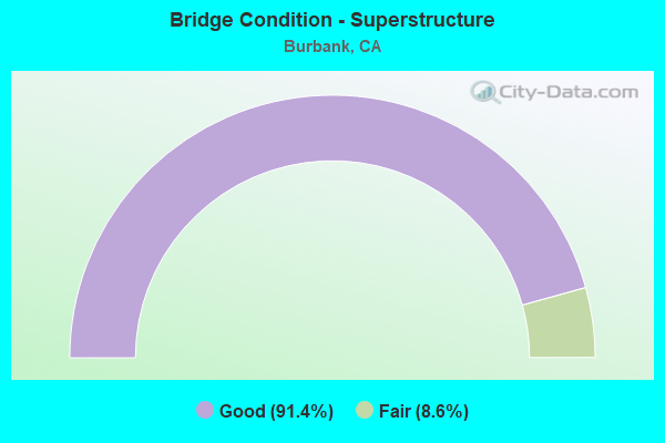
- Bridge Condition - Superstructure
- 91.4%Good
- 8.6%Fair
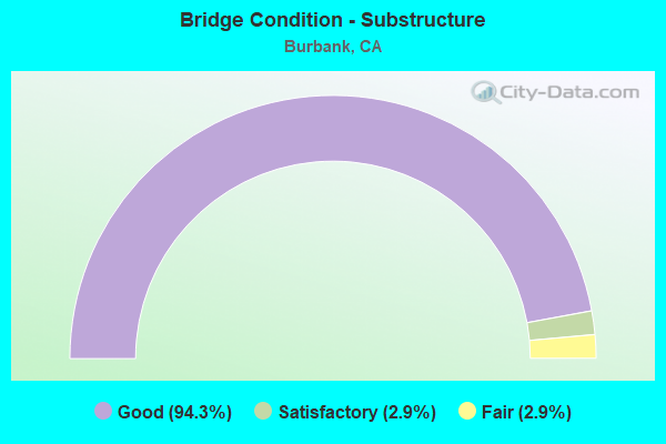
- Bridge Condition - Substructure
- 94.3%Good
- 2.9%Satisfactory
- 2.9%Fair
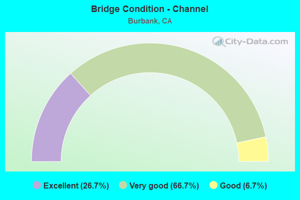
- Bridge Condition - Channel
- 26.7%Excellent
- 66.7%Very good
- 6.7%Good
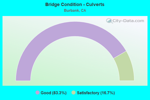
- Bridge Condition - Culverts
- 83.3%Good
- 16.7%Satisfactory
Find on map >> Show street view
Structure Number: 53 1081, Location: 07-LA-005-28.14-GNDL (Lat: 34.167572, Lng: -118.300147), Route carried "on" structure: Interstate 5, Year Built: 1957, Year Reconstructed: 2014, Status: Open, Structure Length: 1.97m (6.46ft), Average Daily Traffic: 239,010 (year 2010), Truck Traffic: 8%, Average Future Daily Traffic: 244,500 (year 2037), Design Load: HS 20, Features Intersected: ALLEN AVENUE
Minimum Vertical Clearance: 30+ m (98+ ft), Kilometerpoint: 28.140, Lanes on structure: 10, Lanes under structure: 2, Base Highway Network: Yes (, Subroute: 1), Owner: State Highway Agency, Approaching Roadway Width: 53.6m (175.9ft), Skew: 30 degrees, Material/Design: Concrete, Design/Construction: Tee Beam, Number Of Spans In Main Unit: 1, Length of Maximum Span: 18.7m (61.4ft), Curb-To-Curb Width: 53.6m (175.9ft), Out-to-Out Width: 55.2m (181.1ft)
Condition: Deck: Good, Superstructure: Good, Substructure: Good, Operating Rating: 32.4 metric tons, Method Used To Determine Operating Rating: Load and Resistance Factor Rating (LRFR) rating reported by rating factor(RF) method using HL-93 loadings, Inventory Rating: 24.9 metric tons, Method Used To Determine Inventory Rating: Load and Resistance Factor Rating (LRFR) rating reported by rating factor(RF) method using HL-93 loadings, Structural Evaluation: Equal to present minimum criteria, Deck Geometry: Superior to present desirable criteria, Underclear: Meets minimum limits, Approach Roadway Alignment: Equal to present desirable criteria, Designated Inspection Frequency: Every 24 months, Inspection Date: November 2020, Deck Structure Type: Concrete Cast-file-Place
Find on map >> Show street view
Structure Number: 53 1082K, Location: 07-LA-005-28.43-BRB (Lat: 34.170014, Lng: -118.304325), Route carried "on" structure: Ramp Interstate 5, Year Built: 1957, Year Reconstructed: 2016, Status: Open, Structure Length: 3.25m (10.66ft), Average Daily Traffic: 7,805 (year 2011), Truck Traffic: 2%, Average Future Daily Traffic: 9,615 (year 2037), Design Load: HS 20, Features Intersected: ALAMEDA AVE
Minimum Vertical Clearance: 30+ m (98+ ft), Kilometerpoint: 28.430, Lanes on structure: 2, Lanes under structure: 5, Base Highway Network: Yes (, Subroute: 1), Owner: State Highway Agency, Approaching Roadway Width: 8.6m (28.2ft), Material/Design: Steel, Design/Construction: Stringer/Multi-beam, Number Of Spans In Main Unit: 2, Length of Maximum Span: 15.6m (51.2ft), Curb-To-Curb Width: 8.6m (28.2ft), Out-to-Out Width: 9.5m (31.2ft)
Condition: Deck: Good, Superstructure: Good, Substructure: Good, Operating Rating: 52.8 metric tons, Method Used To Determine Operating Rating: Field evaluation and documented engineering judgment, Inventory Rating: 32.4 metric tons, Method Used To Determine Inventory Rating: Field evaluation and documented engineering judgment, Structural Evaluation: Better than present minimum criteria, Deck Geometry: Meets minimum limits, Underclear: Meets minimum limits, Approach Roadway Alignment: Equal to present desirable criteria, Designated Inspection Frequency: Every 24 months, Other Special Inspection Frequency: Every 48 months, Inspection Date: November 2020, Other Special Inspection Date: September 2019, Deck Structure Type: Concrete Cast-file-Place
Find on map >> Show street view
Structure Number: 53 1082L, Location: 07-LA-005-28.43-BRB (Lat: 34.170153, Lng: -118.304175), Route carried "on" structure: Interstate 5, Year Built: 1957, Year Reconstructed: 2016, Status: Open, Structure Length: 3.25m (10.66ft), Average Daily Traffic: 119,500 (year 2009), Truck Traffic: 8%, Average Future Daily Traffic: 122,029 (year 2042), Design Load: HS 20, Features Intersected: ALAMEDA AVE
Minimum Vertical Clearance: 30+ m (98+ ft), Kilometerpoint: 28.430, Lanes on structure: 4, Lanes under structure: 5, Base Highway Network: Yes (, Subroute: 1), Owner: State Highway Agency, Approaching Roadway Width: 19.7m (64.6ft), Material/Design: Steel, Design/Construction: Stringer/Multi-beam, Number Of Spans In Main Unit: 2, Length of Maximum Span: 15.6m (51.2ft), Curb-To-Curb Width: 19.7m (64.6ft), Out-to-Out Width: 20.6m (67.6ft)
Condition: Deck: Good, Superstructure: Good, Substructure: Good, Operating Rating: 52.8 metric tons, Method Used To Determine Operating Rating: Field evaluation and documented engineering judgment, Inventory Rating: 32.4 metric tons, Method Used To Determine Inventory Rating: Field evaluation and documented engineering judgment, Structural Evaluation: Better than present minimum criteria, Deck Geometry: Equal to present minimum criteria, Underclear: Meets minimum limits, Approach Roadway Alignment: Equal to present desirable criteria, Designated Inspection Frequency: Every 24 months, Other Special Inspection Frequency: Every 48 months, Inspection Date: November 2020, Other Special Inspection Date: September 2019, Deck Structure Type: Concrete Cast-file-Place
Find on map >> Show street view
Structure Number: 53 1082R, Location: 07-LA-005-28.43-BRB (Lat: 34.170289, Lng: -118.304039), Route carried "on" structure: Interstate 5, Year Built: 1957, Year Reconstructed: 2020, Status: Open, Structure Length: 3.25m (10.66ft), Average Daily Traffic: 254,684 (year 2011), Truck Traffic: 8%, Average Future Daily Traffic: 258,686 (year 2037), Design Load: HS 20, Features Intersected: ALAMEDA AVE
Minimum Vertical Clearance: 30+ m (98+ ft), Kilometerpoint: 28.430, Lanes on structure: 12, Lanes under structure: 5, Base Highway Network: Yes (, Subroute: 1), Owner: State Highway Agency, Approaching Roadway Width: 44.4m (145.7ft), Skew: 30 degrees, Material/Design: Steel, Design/Construction: Stringer/Multi-beam, Number Of Spans In Main Unit: 2, Length of Maximum Span: 15.6m (51.2ft), Curb-To-Curb Width: 44.4m (145.7ft), Out-to-Out Width: 45.9m (150.6ft)
Condition: Deck: Good, Superstructure: Good, Substructure: Good, Operating Rating: 52.8 metric tons, Method Used To Determine Operating Rating: Field evaluation and documented engineering judgment, Inventory Rating: 32.4 metric tons, Method Used To Determine Inventory Rating: Field evaluation and documented engineering judgment, Structural Evaluation: Better than present minimum criteria, Deck Geometry: High priority of corrective action, Underclear: Meets minimum limits, Approach Roadway Alignment: Equal to present desirable criteria, Designated Inspection Frequency: Every 24 months, Other Special Inspection Frequency: Every 48 months, Inspection Date: November 2020, Other Special Inspection Date: September 2019, Deck Structure Type: Concrete Cast-file-Place
Find on map >> Show street view
Structure Number: 53 1082S, Location: 07-LA-005-28.43-BRB (Lat: 34.170386, Lng: -118.303931), Route carried "on" structure: Bypass Interstate 5, Year Built: 1957, Year Reconstructed: 2016, Status: Open, Structure Length: 3.25m (10.66ft), Average Daily Traffic: 8,010 (year 2011), Truck Traffic: 2%, Average Future Daily Traffic: 9,830 (year 2037), Design Load: HS 20, Features Intersected: ALAMEDA AVE
Minimum Vertical Clearance: 30+ m (98+ ft), Kilometerpoint: 28.430, Lanes on structure: 2, Lanes under structure: 6, Base Highway Network: Yes (, Subroute: 1), Owner: State Highway Agency, Approaching Roadway Width: 8.6m (28.2ft), Material/Design: Steel, Design/Construction: Stringer/Multi-beam, Number Of Spans In Main Unit: 2, Length of Maximum Span: 15.6m (51.2ft), Curb-To-Curb Width: 8.6m (28.2ft), Out-to-Out Width: 9.5m (31.2ft)
Condition: Deck: Good, Superstructure: Good, Substructure: Good, Operating Rating: 52.8 metric tons, Method Used To Determine Operating Rating: Field evaluation and documented engineering judgment, Inventory Rating: 32.4 metric tons, Method Used To Determine Inventory Rating: Field evaluation and documented engineering judgment, Structural Evaluation: Better than present minimum criteria, Deck Geometry: High priority of replacement, Underclear: Meets minimum limits, Approach Roadway Alignment: Equal to present desirable criteria, Designated Inspection Frequency: Every 48 months, Other Special Inspection Frequency: Every 48 months, Inspection Date: November 2020, Other Special Inspection Date: September 2019, Deck Structure Type: Concrete Cast-file-Place
Find on map >> Show street view
Structure Number: 53 1085L, Location: 07-LA-005-28.70-BRB (Lat: 34.173619, Lng: -118.306517), Route carried "on" structure: Interstate 5, Year Built: 1959, Year Reconstructed: 2020, Status: Open, Structure Length: 22.25m (73.00ft), Average Daily Traffic: 119,510 (year 2011), Truck Traffic: 8%, Average Future Daily Traffic: 119,620 (year 2037), Design Load: HS 20, Features Intersected: METROLINK,UP RR,AMTRAK,
Minimum Vertical Clearance: 30+ m (98+ ft), Kilometerpoint: 28.700, Lanes on structure: 5, Lanes under structure: 2, Base Highway Network: Yes (, Subroute: 1), Owner: State Highway Agency, Approaching Roadway Width: 27.9m (91.5ft), Skew: 5 degrees, Material/Design: Steel, Design/Construction: Stringer/Multi-beam, Number Of Spans In Main Unit: 8, Length of Maximum Span: 33.4m (109.6ft), Curb-To-Curb Width: 27.9m (91.5ft), Out-to-Out Width: 28.8m (94.5ft)
Condition: Deck: Good, Superstructure: Good, Substructure: Good, Operating Rating: 48.0 metric tons, Method Used To Determine Operating Rating: Load and Resistance Factor Rating (LRFR) rating reported by rating factor(RF) method using HL-93 loadings, Inventory Rating: 37.3 metric tons, Method Used To Determine Inventory Rating: Load and Resistance Factor Rating (LRFR) rating reported by rating factor(RF) method using HL-93 loadings, Structural Evaluation: Better than present minimum criteria, Deck Geometry: Superior to present desirable criteria, Underclear: Equal to present minimum criteria, Approach Roadway Alignment: Somewhat better than minimum adequacy, Designated Inspection Frequency: Every 24 months, Other Special Inspection Frequency: Every 48 months, Inspection Date: December 2020, Other Special Inspection Date: June 2019, Deck Structure Type: Concrete Cast-file-Place
Find on map >> Show street view
Structure Number: 53 1085R, Location: 07-LA-005-28.70-BRB (Lat: 34.173403, Lng: -118.306214), Route carried "on" structure: Interstate 5, Year Built: 1959, Year Reconstructed: 2020, Status: Open, Structure Length: 22.56m (74.02ft), Average Daily Traffic: 119,510 (year 2011), Truck Traffic: 8%, Average Future Daily Traffic: 119,620 (year 2037), Design Load: HS 20, Features Intersected: METROLINK,UP RR,AMTRAK,
Minimum Vertical Clearance: 30+ m (98+ ft), Kilometerpoint: 28.700, Lanes on structure: 5, Lanes under structure: 2, Base Highway Network: Yes (, Subroute: 1), Owner: State Highway Agency, Approaching Roadway Width: 28.2m (92.5ft), Skew: 5 degrees, Material/Design: Steel, Design/Construction: Stringer/Multi-beam, Number Of Spans In Main Unit: 8, Length of Maximum Span: 33.4m (109.6ft), Curb-To-Curb Width: 29.1m (95.5ft), Out-to-Out Width: 30.0m (98.4ft)
Condition: Deck: Good, Superstructure: Good, Substructure: Good, Operating Rating: 43.1 metric tons, Method Used To Determine Operating Rating: Load and Resistance Factor Rating (LRFR) rating reported by rating factor(RF) method using HL-93 loadings, Inventory Rating: 33.0 metric tons, Method Used To Determine Inventory Rating: Load and Resistance Factor Rating (LRFR) rating reported by rating factor(RF) method using HL-93 loadings, Structural Evaluation: Better than present minimum criteria, Deck Geometry: Superior to present desirable criteria, Underclear: Somewhat better than minimum adequacy, Approach Roadway Alignment: Equal to present desirable criteria, Designated Inspection Frequency: Every 24 months, Other Special Inspection Frequency: Every 48 months, Inspection Date: December 2020, Other Special Inspection Date: June 2019, Deck Structure Type: Concrete Cast-file-Place
Find on map >> Show street view
Structure Number: 53 1086, Location: 07-LA-005-28.92-BRB (Lat: 34.176697, Lng: -118.307678), Route carried "on" structure: Interstate 5, Year Built: 1959, Year Reconstructed: 2016, Status: Open, Structure Length: 2.53m (8.30ft), Average Daily Traffic: 239,020 (year 2011), Truck Traffic: 8%, Average Future Daily Traffic: 239,240 (year 2037), Design Load: HS 20, Features Intersected: VERDUGO AVE
Minimum Vertical Clearance: 30+ m (98+ ft), Kilometerpoint: 28.920, Lanes on structure: 10, Lanes under structure: 2, Base Highway Network: Yes (, Subroute: 1), Owner: State Highway Agency, Approaching Roadway Width: 56.1m (184.1ft), Skew: 31 degrees, Material/Design: Steel, Design/Construction: Stringer/Multi-beam, Number Of Spans In Main Unit: 1, Length of Maximum Span: 24.1m (79.1ft), Curb-To-Curb Width: 56.1m (184.1ft), Out-to-Out Width: 57.6m (189.0ft)
Condition: Deck: Good, Superstructure: Good, Substructure: Good, Operating Rating: 81.0 metric tons, Method Used To Determine Operating Rating: Load Factor (LF), Inventory Rating: 48.6 metric tons, Method Used To Determine Inventory Rating: Load Factor (LF), Structural Evaluation: Better than present minimum criteria, Deck Geometry: Superior to present desirable criteria, Underclear: Meets minimum limits, Approach Roadway Alignment: Somewhat better than minimum adequacy, Designated Inspection Frequency: Every 24 months, Inspection Date: December 2020, Deck Structure Type: Concrete Cast-file-Place
Find on map >> Show street view
Structure Number: 53 1087, Location: 07-LA-005-29.16-BRB (Lat: 34.177847, Lng: -118.311864), Route carried "on" structure: City street L426, Year Built: 1959, Status: Open, Structure Length: 7.86m (25.79ft), Average Daily Traffic: 39,854 (year 2011), Truck Traffic: 1%, Average Future Daily Traffic: 52,363 (year 2037), Design Load: HS 20, Features Intersected: ROUTE 5 & OLIVE AVE, Facility Carried by Structure: OLIVE AVE
Minimum Vertical Clearance: 30+ m (98+ ft), Kilometerpoint: 0.000, Lanes on structure: 5, Lanes under structure: 10, Base Highway Network: Yes, Owner: State Highway Agency, Approaching Roadway Width: 15.8m (51.8ft), Material/Design: Concrete continuous, Design/Construction: Box Beam or Girders - Multiple, Number Of Spans In Main Unit: 3, Length of Maximum Span: 27.7m (90.9ft), Curb or Sidewalk Widths: Left: 1.8m (5.9ft), Right: 1.8m (5.9ft), Curb-To-Curb Width: 15.8m (51.8ft), Out-to-Out Width: 20.1m (65.9ft)
Condition: Deck: Good, Superstructure: Good, Substructure: Good, Operating Rating: 33.4 metric tons, Method Used To Determine Operating Rating: Load and Resistance Factor Rating (LRFR) rating reported by rating factor(RF) method using HL-93 loadings, Inventory Rating: 23.7 metric tons, Method Used To Determine Inventory Rating: Load and Resistance Factor Rating (LRFR) rating reported by rating factor(RF) method using HL-93 loadings, Structural Evaluation: Somewhat better than minimum adequacy, Deck Geometry: High priority of replacement, Underclear: Equal to present minimum criteria, Approach Roadway Alignment: Equal to present minimum criteria, Designated Inspection Frequency: Every 24 months, Inspection Date: December 2020, Deck Structure Type: Concrete Cast-file-Place
Find on map >> Show street view
Structure Number: 53 1088, Location: 07-LA-005-29.39-BRB (Lat: 34.179633, Lng: -118.315344), Route carried "on" structure: City street L301, Year Built: 1959, Status: Open, Structure Length: 10.58m (34.71ft), Average Daily Traffic: 33,212 (year 2011), Truck Traffic: 6%, Average Future Daily Traffic: 43,640 (year 2037), Design Load: HS 20, Features Intersected: ROUTE 5 & FRONTAGE RD, Facility Carried by Structure: MAGNOLIA BOULEVARD
Minimum Vertical Clearance: 30+ m (98+ ft), Kilometerpoint: 0.000, Lanes on structure: 5, Lanes under structure: 13, Owner: State Highway Agency, Approaching Roadway Width: 15.8m (51.8ft), Skew: 1 degrees, Material/Design: Concrete, Design/Construction: Stringer/Multi-beam, Number Of Spans In Main Unit: 4, Length of Maximum Span: 27.1m (88.9ft), Curb or Sidewalk Widths: Left: 1.8m (5.9ft), Right: 1.8m (5.9ft), Curb-To-Curb Width: 15.8m (51.8ft), Out-to-Out Width: 20.1m (65.9ft)
Condition: Deck: Good, Superstructure: Good, Substructure: Good, Operating Rating: 87.5 metric tons, Method Used To Determine Operating Rating: Load Factor (LF), Inventory Rating: 32.4 metric tons, Method Used To Determine Inventory Rating: Load Factor (LF), Structural Evaluation: Better than present minimum criteria, Deck Geometry: High priority of replacement, Underclear: High priority of corrective action, Approach Roadway Alignment: Equal to present desirable criteria, Designated Inspection Frequency: Every 48 months, Inspection Date: December 2020, Deck Structure Type: Concrete Cast-file-Place
Find on map >> Show street view
Structure Number: 53 1111, Location: 07-LA-005-31.86-BRB (Lat: 34.206444, Lng: -118.342714), Route carried "on" structure: Interstate 5, Year Built: 1960, Year Reconstructed: 2013, Status: Open, Structure Length: 2.71m (8.89ft), Average Daily Traffic: 187,358 (year 2011), Truck Traffic: 9%, Average Future Daily Traffic: 245,307 (year 2042), Design Load: HS 20, Features Intersected: COHASSET STREET
Minimum Vertical Clearance: 30+ m (98+ ft), Kilometerpoint: 31.860, Lanes on structure: 12, Lanes under structure: 2, Base Highway Network: Yes (, Subroute: 1), Owner: State Highway Agency, Approaching Roadway Width: 53.3m (174.9ft), Skew: 33 degrees, Material/Design: Concrete, Design/Construction: Box Beam or Girders - Multiple, Number Of Spans In Main Unit: 1, Length of Maximum Span: 25.6m (84.0ft), Curb-To-Curb Width: 53.2m (174.5ft), Out-to-Out Width: 54.9m (180.1ft)
Condition: Deck: Good, Superstructure: Good, Substructure: Good, Operating Rating: 99.8 metric tons, Method Used To Determine Operating Rating: Load Factor (LF), Inventory Rating: 67.1 metric tons, Method Used To Determine Inventory Rating: Load Factor (LF), Structural Evaluation: Better than present minimum criteria, Deck Geometry: Superior to present desirable criteria, Underclear: Somewhat better than minimum adequacy, Approach Roadway Alignment: Superior to present desirable criteria, Designated Inspection Frequency: Every 48 months, Inspection Date: December 2020, Deck Structure Type: Concrete Cast-file-Place
Find on map >> Show street view
Structure Number: 53 127, Location: 07-LA-001-12.01-LA (Lat: 33.791103, Lng: -118.287408), Route carried "on" structure: State highway 1, Year Built: 1934, Year Reconstructed: 1975, Status: Open, Structure Length: 3.08m (10.10ft), Average Daily Traffic: 50,000 (year 2017), Truck Traffic: 5%, Average Future Daily Traffic: 60,253 (year 2038), Design Load: HS 20, Features Intersected: BIXBY SLOUGH
Minimum Vertical Clearance: 30+ m (98+ ft), Kilometerpoint: 12.010, Lanes on structure: 6, Base Highway Network: Yes (, Subroute: 1), Owner: State Highway Agency, Approaching Roadway Width: 24.7m (81.0ft), Material/Design: Concrete, Design/Construction: Culvert, Number Of Spans In Main Unit: 8, Length of Maximum Span: 4.3m (14.1ft), Curb or Sidewalk Widths: Left: 2.6m (8.5ft), Right: 2.6m (8.5ft), Curb-To-Curb Width: 24.7m (81.0ft), Out-to-Out Width: 30.0m (98.4ft)
Condition: Channel: Very good, Culverts: Good, Operating Rating: 40.5 metric tons, Method Used To Determine Operating Rating: Field evaluation and documented engineering judgment, Inventory Rating: 24.3 metric tons, Method Used To Determine Inventory Rating: Field evaluation and documented engineering judgment, Structural Evaluation: Equal to present minimum criteria, Deck Geometry: Somewhat better than minimum adequacy, Waterway Adequacy: Equal to present minimum criteria, Approach Roadway Alignment: Equal to present desirable criteria, Designated Inspection Frequency: Every 24 months, Inspection Date: October 2021
Find on map >> Show street view
Structure Number: 53 1277, Location: 07-LA-134-1.82-BRB (Lat: 34.154428, Lng: -118.345328), Route carried "on" structure: City street , Year Built: 1962, Year Reconstructed: 2011, Status: Open, Structure Length: 8.38m (27.49ft), Average Daily Traffic: 18,900 (year 2012), Truck Traffic: 1%, Average Future Daily Traffic: 28,609 (year 2039), Design Load: HS 20, Features Intersected: STATE ROUTE 134 & ONRAMP, Facility Carried by Structure: PASS AVE
Minimum Vertical Clearance: 30+ m (98+ ft), Kilometerpoint: 0.000, Lanes on structure: 4, Lanes under structure: 11, Owner: State Highway Agency, Approaching Roadway Width: 18.3m (60.0ft), Skew: 2 degrees, Material/Design: Concrete continuous, Design/Construction: Box Beam or Girders - Multiple, Number Of Spans In Main Unit: 3, Number Of Approach Spans: 1, Length of Maximum Span: 25.8m (84.6ft), Curb or Sidewalk Widths: Left: 1.8m (5.9ft), Right: 1.8m (5.9ft), Curb-To-Curb Width: 18.3m (60.0ft), Out-to-Out Width: 22.6m (74.1ft)
Condition: Deck: Good, Superstructure: Good, Substructure: Good, Operating Rating: 44.1 metric tons, Method Used To Determine Operating Rating: Load and Resistance Factor Rating (LRFR) rating reported by rating factor(RF) method using HL-93 loadings, Inventory Rating: 34.0 metric tons, Method Used To Determine Inventory Rating: Load and Resistance Factor Rating (LRFR) rating reported by rating factor(RF) method using HL-93 loadings, Structural Evaluation: Better than present minimum criteria, Deck Geometry: Somewhat better than minimum adequacy, Underclear: High priority of corrective action, Approach Roadway Alignment: Equal to present desirable criteria, Designated Inspection Frequency: Every 48 months, Inspection Date: October 2021, Deck Structure Type: Concrete Cast-file-Place
Find on map >> Show street view
Structure Number: 53 1278, Location: 07-LA-134-2.03-BRB (Lat: 34.154050, Lng: -118.341025), Route carried "on" structure: City street , Year Built: 1962, Year Reconstructed: 2011, Status: Open, Structure Length: 11.14m (36.55ft), Average Daily Traffic: 40,200 (year 2015), Truck Traffic: 1%, Average Future Daily Traffic: 48,742 (year 2039), Design Load: HS 20, Features Intersected: STATE ROUTE 134 & ONRAMP, Facility Carried by Structure: ALAMEDA AVE
Minimum Vertical Clearance: 30+ m (98+ ft), Kilometerpoint: 0.000, Lanes on structure: 5, Lanes under structure: 10, Base Highway Network: Yes, Owner: State Highway Agency, Approaching Roadway Width: 24.3m (79.7ft), Skew: 5 degrees, Material/Design: Concrete continuous, Design/Construction: Box Beam or Girders - Multiple, Number Of Spans In Main Unit: 3, Length of Maximum Span: 44.2m (145.0ft), Curb or Sidewalk Widths: Left: 1.8m (5.9ft), Right: 1.8m (5.9ft), Curb-To-Curb Width: 24.3m (79.7ft), Out-to-Out Width: 28.7m (94.2ft)
Condition: Deck: Good, Superstructure: Fair, Substructure: Good, Operating Rating: 49.9 metric tons, Method Used To Determine Operating Rating: Load and Resistance Factor Rating (LRFR) rating reported by rating factor(RF) method using HL-93 loadings, Inventory Rating: 37.3 metric tons, Method Used To Determine Inventory Rating: Load and Resistance Factor Rating (LRFR) rating reported by rating factor(RF) method using HL-93 loadings, Structural Evaluation: Somewhat better than minimum adequacy, Deck Geometry: Superior to present desirable criteria, Underclear: High priority of corrective action, Approach Roadway Alignment: Equal to present desirable criteria, Designated Inspection Frequency: Every 24 months, Inspection Date: October 2021, Deck Structure Type: Concrete Cast-file-Place
Find on map >> Show street view
Structure Number: 53 1279, Location: 07-LA-134-2.11-BRB (Lat: 34.153867, Lng: -118.340356), Route carried "on" structure: City street , Year Built: 1962, Year Reconstructed: 2011, Status: Open, Structure Length: 8.11m (26.61ft), Average Daily Traffic: 24,500 (year 2012), Truck Traffic: 1%, Average Future Daily Traffic: 37,086 (year 2040), Design Load: HS 20, Features Intersected: STATE ROUTE 134 & RAMPS, Facility Carried by Structure: HOLLYWOOD WAY
Minimum Vertical Clearance: 30+ m (98+ ft), Kilometerpoint: 0.000, Lanes on structure: 5, Lanes under structure: 11, Base Highway Network: Yes, Owner: State Highway Agency, Approaching Roadway Width: 24.4m (80.1ft), Skew: 3 degrees, Material/Design: Concrete continuous, Design/Construction: Box Beam or Girders - Multiple, Number Of Spans In Main Unit: 4, Length of Maximum Span: 26.4m (86.6ft), Curb or Sidewalk Widths: Left: 1.8m (5.9ft), Right: 1.8m (5.9ft), Curb-To-Curb Width: 24.4m (80.1ft), Out-to-Out Width: 28.7m (94.2ft)
Condition: Deck: Fair, Superstructure: Good, Substructure: Good, Operating Rating: 41.5 metric tons, Method Used To Determine Operating Rating: Load and Resistance Factor Rating (LRFR) rating reported by rating factor(RF) method using HL-93 loadings, Inventory Rating: 32.1 metric tons, Method Used To Determine Inventory Rating: Load and Resistance Factor Rating (LRFR) rating reported by rating factor(RF) method using HL-93 loadings, Structural Evaluation: Better than present minimum criteria, Deck Geometry: Superior to present desirable criteria, Underclear: High priority of corrective action, Approach Roadway Alignment: Equal to present desirable criteria, Designated Inspection Frequency: Every 24 months, Inspection Date: October 2021, Deck Structure Type: Concrete Cast-file-Place
Find on map >> Show street view
Structure Number: 53 1281, Location: 07-LA-134-2.39-BRB (Lat: 34.152869, Lng: -118.335306), Route carried "on" structure: City street , Year Built: 1962, Status: Open, Structure Length: 4.53m (14.86ft), Average Daily Traffic: 3,500 (year 2012), Truck Traffic: 2%, Average Future Daily Traffic: 5,299 (year 2039), Design Load: HS 20, Features Intersected: STATE ROUTE 134, Facility Carried by Structure: CALIFORNIA STREET
Minimum Vertical Clearance: 30+ m (98+ ft), Kilometerpoint: 0.000, Lanes on structure: 2, Lanes under structure: 10, Owner: State Highway Agency, Approaching Roadway Width: 12.2m (40.0ft), Material/Design: Concrete continuous, Design/Construction: Box Beam or Girders - Multiple, Number Of Spans In Main Unit: 2, Length of Maximum Span: 21.4m (70.2ft), Curb or Sidewalk Widths: Left: 1.8m (5.9ft), Right: 1.8m (5.9ft), Curb-To-Curb Width: 12.2m (40.0ft), Out-to-Out Width: 16.5m (54.1ft)
Condition: Deck: Good, Superstructure: Fair, Substructure: Fair, Operating Rating: 46.7 metric tons, Method Used To Determine Operating Rating: Load and Resistance Factor Rating (LRFR) rating reported by rating factor(RF) method using HL-93 loadings, Inventory Rating: 33.4 metric tons, Method Used To Determine Inventory Rating: Load and Resistance Factor Rating (LRFR) rating reported by rating factor(RF) method using HL-93 loadings, Structural Evaluation: Somewhat better than minimum adequacy, Deck Geometry: Equal to present minimum criteria, Underclear: High priority of corrective action, Approach Roadway Alignment: Equal to present desirable criteria, Designated Inspection Frequency: Every 24 months, Inspection Date: October 2021, Deck Structure Type: Concrete Cast-file-Place
Find on map >> Show street view
Structure Number: 53 1282, Location: 07-LA-134-2.67-BRB (Lat: 34.152661, Lng: -118.330447), Route carried "on" structure: State highway 134, Year Built: 1962, Year Reconstructed: 2014, Status: Open, Structure Length: 3.63m (11.91ft), Average Daily Traffic: 219,000 (year 2015), Truck Traffic: 4%, Average Future Daily Traffic: 283,846 (year 2039), Design Load: HS 20, Features Intersected: BOB HOPE DRIVE
Minimum Vertical Clearance: 5.18m (16.99ft), Kilometerpoint: 2.670, Lanes on structure: 10, Lanes under structure: 2, Base Highway Network: Yes (Inventory Route: 1, Subroute: 1), Owner: State Highway Agency, Approaching Roadway Width: 45.1m (148.0ft), Skew: 30 degrees, Material/Design: Concrete, Design/Construction: Box Beam or Girders - Multiple, Number Of Spans In Main Unit: 1, Number Of Approach Spans: 2, Length of Maximum Span: 19.2m (63.0ft), Curb or Sidewalk Widths: Left: 0.6m (2.0ft), Right: 0.0m, Curb-To-Curb Width: 45.1m (148.0ft), Out-to-Out Width: 46.7m (153.2ft)
Condition: Deck: Fair, Superstructure: Good, Substructure: Good, Operating Rating: 67.7 metric tons, Method Used To Determine Operating Rating: Load Factor (LF), Inventory Rating: 40.8 metric tons, Method Used To Determine Inventory Rating: Load Factor (LF), Structural Evaluation: Better than present minimum criteria, Deck Geometry: Equal to present desirable criteria, Underclear: Meets minimum limits, Approach Roadway Alignment: Equal to present desirable criteria, Designated Inspection Frequency: Every 24 months, Inspection Date: October 2021, Deck Structure Type: Concrete Cast-file-Place
Find on map >> Show street view
Structure Number: 53 1283, Location: 07-LA-134-2.90-BRB (Lat: 34.153386, Lng: -118.326761), Route carried "on" structure: State highway 134, Year Built: 1962, Status: Open, Structure Length: 7.64m (25.07ft), Average Daily Traffic: 213,000 (year 2017), Truck Traffic: 4%, Average Future Daily Traffic: 283,846 (year 2039), Design Load: HS 20, Features Intersected: RIVERSIDE DR & ON-RAMP
Minimum Vertical Clearance: 30+ m (98+ ft), Kilometerpoint: 2.900, Lanes on structure: 10, Lanes under structure: 6, Base Highway Network: Yes (Inventory Route: 1, Subroute: 1), Owner: State Highway Agency, Approaching Roadway Width: 40.2m (131.9ft), Skew: 39 degrees, Material/Design: Concrete continuous, Design/Construction: Box Beam or Girders - Multiple, Number Of Spans In Main Unit: 3, Length of Maximum Span: 38.4m (126.0ft), Curb-To-Curb Width: 40.2m (131.9ft), Out-to-Out Width: 41.7m (136.8ft)
Condition: Deck: Fair, Superstructure: Good, Substructure: Good, Operating Rating: 99.8 metric tons, Method Used To Determine Operating Rating: Load Factor (LF), Inventory Rating: 71.0 metric tons, Method Used To Determine Inventory Rating: Load Factor (LF), Structural Evaluation: Better than present minimum criteria, Deck Geometry: Meets minimum limits, Underclear: High priority of corrective action, Approach Roadway Alignment: Equal to present desirable criteria, Designated Inspection Frequency: Every 24 months, Inspection Date: October 2021, Deck Structure Type: Concrete Cast-file-Place
Find on map >> Show street view
Structure Number: 53 1368S, Location: 07-LA-005-31.35-BRB (Lat: 34.200697, Lng: -118.338417), Route carried "on" structure: Ramp Interstate 5, Year Built: 1960, Status: Open, Structure Length: 1.28m (4.20ft), Average Daily Traffic: 9,996 (year 2009), Truck Traffic: 2%, Average Future Daily Traffic: 12,439 (year 2036), Features Intersected: BURBANK WESTERN CHANNEL
Minimum Vertical Clearance: 30+ m (98+ ft), Kilometerpoint: 31.350, Lanes on structure: 3, Base Highway Network: Yes (, Subroute: 1), Owner: State Highway Agency, Approaching Roadway Width: 41.5m (136.2ft), Skew: 33 degrees, Material/Design: Concrete, Design/Construction: Culvert, Number Of Spans In Main Unit: 1, Length of Maximum Span: 11.9m (39.0ft), Curb-To-Curb Width: 41.5m (136.2ft), Out-to-Out Width: 41.5m (136.2ft)
Condition: Channel: Very good, Culverts: Good, Operating Rating: 54.1 metric tons, Method Used To Determine Operating Rating: Field evaluation and documented engineering judgment, Inventory Rating: 32.4 metric tons, Method Used To Determine Inventory Rating: Field evaluation and documented engineering judgment, Structural Evaluation: Better than present minimum criteria, Deck Geometry: Superior to present desirable criteria, Waterway Adequacy: Equal to present desirable criteria, Approach Roadway Alignment: Equal to present desirable criteria, Designated Inspection Frequency: Every 48 months, Inspection Date: December 2018
Find on map >> Show street view
Structure Number: 53 1673M, Location: 07-LA-005-30.00-BRB (Lat: 34.187564, Lng: -118.321489), Route carried "on" structure: Interstate 5, Year Built: 1960, Status: Open, Structure Length: 4.51m (14.80ft), Average Daily Traffic: 239,016 (year 2011), Truck Traffic: 8%, Average Future Daily Traffic: 239,240 (year 2037), Features Intersected: BURBANK WEST CHANNEL
Minimum Vertical Clearance: 30+ m (98+ ft), Kilometerpoint: 30.000, Lanes on structure: 8, Base Highway Network: Yes (, Subroute: 1), Owner: State Highway Agency, Approaching Roadway Width: 44.7m (146.7ft), Skew: 37 degrees, Material/Design: Concrete, Design/Construction: Culvert, Number Of Spans In Main Unit: 1, Length of Maximum Span: 42.7m (140.1ft), Curb-To-Curb Width: 44.7m (146.7ft), Out-to-Out Width: 45.1m (148.0ft)
Condition: Channel: Very good, Culverts: Good, Operating Rating: 54.1 metric tons, Method Used To Determine Operating Rating: Field evaluation and documented engineering judgment, Inventory Rating: 32.4 metric tons, Method Used To Determine Inventory Rating: Field evaluation and documented engineering judgment, Structural Evaluation: Better than present minimum criteria, Deck Geometry: Superior to present desirable criteria, Waterway Adequacy: Equal to present desirable criteria, Approach Roadway Alignment: Superior to present desirable criteria, Designated Inspection Frequency: Every 24 months, Inspection Date: December 2020
Find on map >> Show street view
Structure Number: 53 3072, Location: 07-LA-134-2.82-BRB (Lat: 34.153236, Lng: -118.327619), Route carried "on" structure: State highway 134, Year Built: 1959, Status: Open, Structure Length: 1.14m (3.74ft), Average Daily Traffic: 189,000 (year 2011), Truck Traffic: 4%, Average Future Daily Traffic: 283,846 (year 2041), Features Intersected: BUENA VISTA PARK CHANNEL
Minimum Vertical Clearance: 30+ m (98+ ft), Kilometerpoint: 2.820, Lanes on structure: 8, Base Highway Network: Yes (Inventory Route: 1, Subroute: 1), Owner: State Highway Agency, Approaching Roadway Width: 38.4m (126.0ft), Skew: 33 degrees, Material/Design: Concrete continuous, Design/Construction: Culvert, Number Of Spans In Main Unit: 3, Length of Maximum Span: 3.9m (12.8ft), Curb-To-Curb Width: 38.4m (126.0ft), Out-to-Out Width: 52.7m (172.9ft)
Condition: Channel: Good, Culverts: Good, Operating Rating: 54.1 metric tons, Method Used To Determine Operating Rating: Field evaluation and documented engineering judgment, Inventory Rating: 32.4 metric tons, Method Used To Determine Inventory Rating: Field evaluation and documented engineering judgment, Structural Evaluation: Better than present minimum criteria, Deck Geometry: Superior to present desirable criteria, Waterway Adequacy: Equal to present desirable criteria, Approach Roadway Alignment: Equal to present desirable criteria, Designated Inspection Frequency: Every 24 months, Inspection Date: December 2021
Find on map >> Show street view
Structure Number: 53 3078, Location: 07-LA-005-30.08-BRB (Lat: 34.188092, Lng: -118.322044), Route carried "on" structure: Interstate 5, Year Built: 2019, Status: Open, Structure Length: 1.22m (4.00ft), Average Daily Traffic: 23,900 (year 2019), Truck Traffic: 8%, Average Future Daily Traffic: 24,978 (year 2044), Design Load: HS 20, Features Intersected: BURBANK WESTERN CHANNEL
Minimum Vertical Clearance: 99.00m (324.80ft), Kilometerpoint: 30.080, Lanes on structure: 2, Base Highway Network: Yes (, Subroute: 1), Owner: State Highway Agency, Approaching Roadway Width: 12.2m (40.0ft), Skew: 9 degrees, Material/Design: Prestressed concrete, Design/Construction: Slab, Number Of Spans In Main Unit: 1, Number Of Approach Spans: 2, Length of Maximum Span: 12.2m (40.0ft), Curb-To-Curb Width: 12.2m (40.0ft), Out-to-Out Width: 12.2m (40.0ft)
Condition: Deck: Good, Superstructure: Good, Substructure: Good, Channel: Very good, Operating Rating: 54.1 metric tons, Method Used To Determine Operating Rating: Assigned rating based on Load Factor Design (LFD) reported in metric tons, Inventory Rating: 32.4 metric tons, Method Used To Determine Inventory Rating: Assigned rating based on Load Factor Design (LFD) reported in metric tons, Structural Evaluation: Better than present minimum criteria, Deck Geometry: Better than present minimum criteria, Waterway Adequacy: Equal to present desirable criteria, Approach Roadway Alignment: Equal to present desirable criteria, Designated Inspection Frequency: Every 24 months, Inspection Date: January 2022, Deck Structure Type: Concrete Precast Panels
Find on map >> Show street view
Structure Number: 53C0174, Location: 0.3MI S/O I-5 FWY (Lat: 34.167433, Lng: -118.307086), Route carried "on" structure: City street L587, Year Built: 1949, Status: Open, Structure Length: 1.28m (4.20ft), Average Daily Traffic: 36,252 (year 2012), Truck Traffic: 4%, Average Future Daily Traffic: 43,502 (year 2041), Design Load: HS 20, Features Intersected: BURBANK WESTERN CHAN, Facility Carried by Structure: ALAMEDA AVE
Minimum Vertical Clearance: 30.47m (99.97ft), Kilometerpoint: 0.000, Lanes on structure: 4, Owner: City or Municipal Highway Agency, Approaching Roadway Width: 22.9m (75.1ft), Material/Design: Concrete, Design/Construction: Tee Beam, Number Of Spans In Main Unit: 1, Length of Maximum Span: 12.5m (41.0ft), Curb or Sidewalk Widths: Left: 2.7m (8.9ft), Right: 2.7m (8.9ft), Curb-To-Curb Width: 22.9m (75.1ft), Out-to-Out Width: 23.0m (75.5ft)
Condition: Deck: Good, Superstructure: Good, Substructure: Good, Channel: Very good, Operating Rating: 47.3 metric tons, Method Used To Determine Operating Rating: Load Factor (LF), Inventory Rating: 28.5 metric tons, Method Used To Determine Inventory Rating: Load Factor (LF), Structural Evaluation: Better than present minimum criteria, Deck Geometry: Superior to present desirable criteria, Waterway Adequacy: Equal to present desirable criteria, Approach Roadway Alignment: Equal to present desirable criteria, Designated Inspection Frequency: Every 24 months, Inspection Date: January 2022, Deck Structure Type: Concrete Cast-file-Place, Wearing Surface/Protective System: Wearing Surface: Bituminous
Find on map >> Show street view
Structure Number: 53C0190L, Location: 0.1MI E/O I-710 FWY (Lat: 33.903681, Lng: -118.183264), Route carried "on" structure: City street L079, Year Built: 1951, Year Reconstructed: 1972, Status: Open, Structure Length: 18.51m (60.73ft), Average Daily Traffic: 13,699 (year 2012), Truck Traffic: 5%, Average Future Daily Traffic: 15,754 (year 2040), Design Load: HS 20, Features Intersected: LOS ANGELES RIV, Facility Carried by Structure: ROSECRANS AVE W
Minimum Vertical Clearance: 30.47m (99.97ft), Kilometerpoint: 0.000, Lanes on structure: 3, Owner: City or Municipal Highway Agency, Approaching Roadway Width: 11.3m (37.1ft), Skew: 4 degrees, Material/Design: Concrete, Design/Construction: Tee Beam, Number Of Spans In Main Unit: 8, Length of Maximum Span: 25.0m (82.0ft), Curb-To-Curb Width: 11.3m (37.1ft), Out-to-Out Width: 11.8m (38.7ft)
Condition: Deck: Fair, Superstructure: Good, Substructure: Good, Channel: Excellent, Operating Rating: 45.0 metric tons, Method Used To Determine Operating Rating: Load Factor (LF), Inventory Rating: 26.9 metric tons, Method Used To Determine Inventory Rating: Load Factor (LF), Structural Evaluation: Equal to present minimum criteria, Deck Geometry: High priority of replacement, Waterway Adequacy: Superior to present desirable criteria, Approach Roadway Alignment: Equal to present desirable criteria, Designated Inspection Frequency: Every 24 months, Inspection Date: August 2020, Deck Structure Type: Concrete Cast-file-Place
Find on map >> Show street view
Structure Number: 53C0198, Location: 300FT W/O I-5 FWY (Lat: 34.184528, Lng: -118.320597), Route carried "on" structure: City street L570, Year Built: 1958, Year Reconstructed: 2006, Status: Open, Structure Length: 12.45m (40.85ft), Average Daily Traffic: 50,138 (year 2012), Truck Traffic: 20%, Average Future Daily Traffic: 60,166 (year 2041), Design Load: HS 20+Mod, Features Intersected: LAKE ST / SPTCO, Facility Carried by Structure: BURBANK BLVD
Minimum Vertical Clearance: 5.11m (16.77ft), Kilometerpoint: 0.000, Lanes on structure: 6, Lanes under structure: 2, Owner: City or Municipal Highway Agency, Approaching Roadway Width: 19.5m (64.0ft), Skew: 2 degrees, Material/Design: Prestressed concrete, Design/Construction: Box Beam or Girders - Multiple, Number Of Spans In Main Unit: 1, Number Of Approach Spans: 1, Length of Maximum Span: 124.5m (408.5ft), Curb or Sidewalk Widths: Left: 1.6m (5.2ft), Right: 2.3m (7.5ft), Curb-To-Curb Width: 30.1m (98.8ft), Out-to-Out Width: 34.5m (113.2ft)
Condition: Deck: Fair, Superstructure: Good, Substructure: Good, Operating Rating: 44.7 metric tons, Method Used To Determine Operating Rating: Load Factor (LF), Inventory Rating: 26.9 metric tons, Method Used To Determine Inventory Rating: Load Factor (LF), Structural Evaluation: Equal to present minimum criteria, Deck Geometry: Superior to present desirable criteria, Underclear: Somewhat better than minimum adequacy, Approach Roadway Alignment: Better than present minimum criteria, Designated Inspection Frequency: Every 24 months, Inspection Date: December 2021, Deck Structure Type: Concrete Cast-file-Place, Wearing Surface/Protective System: Wearing Surface: Monolithic Concrete
Find on map >> Show street view
Structure Number: 53C02, Location: 0.1MI W/O I-5 FWY (Lat: 34.179622, Lng: -118.315322), Route carried "on" structure: City street , Year Built: 1949, Year Reconstructed: 1959, Status: Open, Structure Length: 1.34m (4.40ft), Average Daily Traffic: 408 (year 2012), Truck Traffic: 2%, Average Future Daily Traffic: 408 (year 2041), Design Load: HS 20, Features Intersected: BURBANK WESTERN CHAN, Facility Carried by Structure: MGNOLIA BLVD F RD
Minimum Vertical Clearance: 30+ m (98+ ft), Kilometerpoint: 0.000, Lanes on structure: 2, Owner: City or Municipal Highway Agency, Approaching Roadway Width: 6.1m (20.0ft), Skew: 20 degrees, Material/Design: Concrete, Design/Construction: Tee Beam, Number Of Spans In Main Unit: 1, Length of Maximum Span: 12.8m (42.0ft), Curb or Sidewalk Widths: Left: 2.3m (7.5ft), Right: 2.8m (9.2ft), Curb-To-Curb Width: 12.2m (40.0ft), Out-to-Out Width: 15.0m (49.2ft)
Condition: Deck: Good, Superstructure: Good, Substructure: Good, Channel: Very good, Operating Rating: 54.8 metric tons, Method Used To Determine Operating Rating: Load Factor (LF), Inventory Rating: 32.4 metric tons, Method Used To Determine Inventory Rating: Load Factor (LF), Structural Evaluation: Better than present minimum criteria, Deck Geometry: Equal to present desirable criteria, Waterway Adequacy: Equal to present desirable criteria, Approach Roadway Alignment: Equal to present desirable criteria, Designated Inspection Frequency: Every 48 months, Inspection Date: January 2022, Deck Structure Type: Concrete Cast-file-Place, Wearing Surface/Protective System: Wearing Surface: Bituminous
Find on map >> Show street view
Structure Number: 53C0741, Location: 0.3MI N/O US-101 FWY (Lat: 34.158333, Lng: -118.266783), Route carried "on" structure: City street Q407, Year Built: 1936, Status: Open, Structure Length: 3.02m (9.91ft), Average Daily Traffic: 2,550 (year 2015), Truck Traffic: 1%, Average Future Daily Traffic: 2,805 (year 2041), Design Load: H 20, Features Intersected: VERDUGO WASH, Facility Carried by Structure: KENILWORTH AVE
Minimum Vertical Clearance: 30.47m (99.97ft), Kilometerpoint: 0.000, Lanes on structure: 2, Owner: City or Municipal Highway Agency, Approaching Roadway Width: 12.2m (40.0ft), Skew: 1 degrees, Material/Design: Steel, Design/Construction: Truss - Thru, Number Of Spans In Main Unit: 1, Length of Maximum Span: 29.0m (95.1ft), Curb or Sidewalk Widths: Left: 1.5m (4.9ft), Right: 1.5m (4.9ft), Curb-To-Curb Width: 12.3m (40.4ft), Out-to-Out Width: 17.1m (56.1ft)
Condition: Deck: Good, Superstructure: Good, Substructure: Good, Channel: Excellent, Operating Rating: 55.4 metric tons, Method Used To Determine Operating Rating: Load Factor (LF), Inventory Rating: 33.0 metric tons, Method Used To Determine Inventory Rating: Load Factor (LF), Structural Evaluation: Better than present minimum criteria, Deck Geometry: Equal to present minimum criteria, Waterway Adequacy: Superior to present desirable criteria, Approach Roadway Alignment: Equal to present desirable criteria, Designated Inspection Frequency: Every 24 months, Critical Feature Inspection Frequency: Every 24 months, Inspection Date: January 2022, Critical Feature Inspection Date: April 2020, Deck Structure Type: Concrete Cast-file-Place, Wearing Surface/Protective System: Wearing Surface: Bituminous
Find on map >> Show street view
Structure Number: 53C0749, Location: 0.3MI E/O I-5 FWY (Lat: 34.172453, Lng: -118.301681), Route carried "on" structure: City street , Year Built: 1963, Status: Open, Structure Length: 2.36m (7.74ft), Average Daily Traffic: 500 (year 2012), Truck Traffic: 2%, Average Future Daily Traffic: 500 (year 2041), Design Load: HS 20, Features Intersected: ALAMEDA AVE, Facility Carried by Structure: E ACCESS RD
Minimum Vertical Clearance: 30.47m (99.97ft), Kilometerpoint: 0.000, Lanes on structure: 1, Lanes under structure: 4, Owner: City or Municipal Highway Agency, Approaching Roadway Width: 6.1m (20.0ft), Material/Design: Concrete continuous, Design/Construction: Slab, Number Of Spans In Main Unit: 2, Length of Maximum Span: 11.6m (38.1ft), Curb or Sidewalk Widths: Left: 1.3m (4.3ft), Right: 0.8m (2.6ft), Curb-To-Curb Width: 7.5m (24.6ft), Out-to-Out Width: 9.9m (32.5ft)
Condition: Deck: Good, Superstructure: Good, Substructure: Good, Operating Rating: 72.9 metric tons, Method Used To Determine Operating Rating: Load Factor (LF), Inventory Rating: 43.4 metric tons, Method Used To Determine Inventory Rating: Load Factor (LF), Structural Evaluation: Better than present minimum criteria, Deck Geometry: Meets minimum limits, Underclear: Meets minimum limits, Approach Roadway Alignment: Meets minimum limits, Designated Inspection Frequency: Every 48 months, Inspection Date: December 2021, Deck Structure Type: Concrete Cast-file-Place
Find on map >> Show street view
Structure Number: 53C0751, Location: 0.3MI E/O I-5 FWY (Lat: 34.172156, Lng: -118.302003), Route carried "on" structure: City street , Year Built: 1963, Status: Open, Structure Length: 2.35m (7.71ft), Average Daily Traffic: 500 (year 2012), Truck Traffic: 2%, Average Future Daily Traffic: 500 (year 2041), Design Load: HS 20, Features Intersected: ALAMEDA AVE, Facility Carried by Structure: W ACCESS RD
Minimum Vertical Clearance: 30+ m (98+ ft), Kilometerpoint: 0.000, Lanes on structure: 1, Lanes under structure: 4, Owner: City or Municipal Highway Agency, Approaching Roadway Width: 6.0m (19.7ft), Material/Design: Concrete continuous, Design/Construction: Slab, Number Of Spans In Main Unit: 2, Length of Maximum Span: 11.6m (38.1ft), Curb or Sidewalk Widths: Left: 0.8m (2.6ft), Right: 1.2m (3.9ft), Curb-To-Curb Width: 7.5m (24.6ft), Out-to-Out Width: 10.1m (33.1ft)
Condition: Deck: Good, Superstructure: Good, Substructure: Good, Operating Rating: 72.9 metric tons, Method Used To Determine Operating Rating: Load Factor (LF), Inventory Rating: 43.4 metric tons, Method Used To Determine Inventory Rating: Load Factor (LF), Structural Evaluation: Better than present minimum criteria, Deck Geometry: Meets minimum limits, Underclear: Meets minimum limits, Approach Roadway Alignment: Meets minimum limits, Designated Inspection Frequency: Every 48 months, Inspection Date: January 2022, Deck Structure Type: Concrete Cast-file-Place
Find on map >> Show street view
Structure Number: 53C0752, Location: 0.3MI E/O ALAMEDA AVE (Lat: 34.164414, Lng: -118.304497), Route carried "on" structure: City street L545, Year Built: 1940, Status: Open, Structure Length: 2.59m (8.50ft), Average Daily Traffic: 22,154 (year 2012), Truck Traffic: 3%, Average Future Daily Traffic: 26,585 (year 2041), Design Load: HS 20, Features Intersected: BURBANK WESTERN CHAN, Facility Carried by Structure: VICTORY BLVD
Minimum Vertical Clearance: 30+ m (98+ ft), Kilometerpoint: 0.000, Lanes on structure: 4, Owner: City or Municipal Highway Agency, Approaching Roadway Width: 20.8m (68.2ft), Skew: 3 degrees, Material/Design: Concrete, Design/Construction: Slab, Number Of Spans In Main Unit: 1, Length of Maximum Span: 25.0m (82.0ft), Curb or Sidewalk Widths: Left: 1.8m (5.9ft), Right: 1.8m (5.9ft), Curb-To-Curb Width: 20.8m (68.2ft), Out-to-Out Width: 24.4m (80.1ft)
Condition: Deck: Good, Superstructure: Good, Substructure: Good, Channel: Excellent, Operating Rating: 55.7 metric tons, Method Used To Determine Operating Rating: Load Factor (LF), Inventory Rating: 33.4 metric tons, Method Used To Determine Inventory Rating: Load Factor (LF), Structural Evaluation: Better than present minimum criteria, Deck Geometry: Superior to present desirable criteria, Waterway Adequacy: Equal to present desirable criteria, Approach Roadway Alignment: Equal to present desirable criteria, Designated Inspection Frequency: Every 48 months, Inspection Date: January 2022, Deck Structure Type: Concrete Cast-file-Place, Wearing Surface/Protective System: Wearing Surface: Bituminous
Find on map >> Show street view
Structure Number: 53C0754, Location: 0.3MI W/O ALAMEDA AVE (Lat: 34.171828, Lng: -118.309486), Route carried "on" structure: City street Q234, Year Built: 1949, Status: Open, Structure Length: 1.34m (4.40ft), Average Daily Traffic: 6,180 (year 2012), Truck Traffic: 4%, Average Future Daily Traffic: 7,107 (year 2041), Design Load: HS 20, Features Intersected: BURBANK WESTERN CHAN, Facility Carried by Structure: LKE ST / PROVI AVE
Minimum Vertical Clearance: 30+ m (98+ ft), Kilometerpoint: 0.000, Lanes on structure: 2, Owner: City or Municipal Highway Agency, Approaching Roadway Width: 13.3m (43.6ft), Skew: 3 degrees, Material/Design: Concrete, Design/Construction: Tee Beam, Number Of Spans In Main Unit: 1, Length of Maximum Span: 12.8m (42.0ft), Curb or Sidewalk Widths: Left: 2.1m (6.9ft), Right: 2.1m (6.9ft), Curb-To-Curb Width: 12.0m (39.4ft), Out-to-Out Width: 16.8m (55.1ft)
Condition: Deck: Good, Superstructure: Good, Substructure: Good, Channel: Very good, Operating Rating: 61.6 metric tons, Method Used To Determine Operating Rating: Load Factor (LF), Inventory Rating: 36.9 metric tons, Method Used To Determine Inventory Rating: Load Factor (LF), Structural Evaluation: Better than present minimum criteria, Deck Geometry: Somewhat better than minimum adequacy, Waterway Adequacy: Equal to present desirable criteria, Approach Roadway Alignment: Equal to present desirable criteria, Designated Inspection Frequency: Every 48 months, Inspection Date: January 2022, Deck Structure Type: Concrete Cast-file-Place, Wearing Surface/Protective System: Wearing Surface: Bituminous
Find on map >> Show street view
Structure Number: 53C0941, Location: 0.5MI N/O VICTORY BLVD (Lat: 34.191639, Lng: -118.349044), Route carried "on" structure: City street L546, Year Built: 1970, Status: Open, Structure Length: 2.74m (8.99ft), Average Daily Traffic: 6,489 (year 2012), Truck Traffic: 1%, Average Future Daily Traffic: 7,462 (year 2041), Design Load: HS 20, Features Intersected: HOLLYWOOD WAY, Facility Carried by Structure: VANOWEN ST
Minimum Vertical Clearance: 5.18m (16.99ft), Kilometerpoint: 0.000, Lanes on structure: 5, Lanes under structure: 4, Owner: City or Municipal Highway Agency, Approaching Roadway Width: 21.4m (70.2ft), Skew: 1 degrees, Material/Design: Concrete continuous, Design/Construction: Slab, Number Of Spans In Main Unit: 2, Length of Maximum Span: 13.4m (44.0ft), Curb or Sidewalk Widths: Left: 0.6m (2.0ft), Right: 2.4m (7.9ft), Curb-To-Curb Width: 18.8m (61.7ft), Out-to-Out Width: 22.5m (73.8ft)
Condition: Deck: Fair, Superstructure: Fair, Substructure: Good, Operating Rating: 66.1 metric tons, Method Used To Determine Operating Rating: Load Factor (LF), Inventory Rating: 39.5 metric tons, Method Used To Determine Inventory Rating: Load Factor (LF), Structural Evaluation: Somewhat better than minimum adequacy, Deck Geometry: Meets minimum limits, Underclear: Meets minimum limits, Approach Roadway Alignment: Equal to present desirable criteria, Designated Inspection Frequency: Every 24 months, Inspection Date: January 2022, Deck Structure Type: Concrete Cast-file-Place
Find on map >> Show street view
Structure Number: 53C0943, Location: 0.5MI N/O VICTORY BLVD (Lat: 34.192211, Lng: -118.349067), Route carried "on" structure: City street L300, Year Built: 1970, Status: Open, Structure Length: 2.68m (8.79ft), Average Daily Traffic: 13,081 (year 2012), Truck Traffic: 2%, Average Future Daily Traffic: 15,043 (year 2041), Design Load: HS 20, Features Intersected: HOLLYWOOD WAY, Facility Carried by Structure: EMPIRE AVE
Minimum Vertical Clearance: 30+ m (98+ ft), Kilometerpoint: 0.000, Lanes on structure: 4, Lanes under structure: 4, Owner: City or Municipal Highway Agency, Approaching Roadway Width: 20.7m (67.9ft), Skew: 1 degrees, Material/Design: Concrete continuous, Design/Construction: Slab, Number Of Spans In Main Unit: 2, Length of Maximum Span: 13.4m (44.0ft), Curb or Sidewalk Widths: Left: 2.5m (8.2ft), Right: 1.9m (6.2ft), Curb-To-Curb Width: 18.9m (62.0ft), Out-to-Out Width: 23.9m (78.4ft)
Condition: Deck: Good, Superstructure: Good, Substructure: Good, Operating Rating: 63.2 metric tons, Method Used To Determine Operating Rating: Load Factor (LF), Inventory Rating: 37.9 metric tons, Method Used To Determine Inventory Rating: Load Factor (LF), Structural Evaluation: Better than present minimum criteria, Deck Geometry: Equal to present minimum criteria, Underclear: Meets minimum limits, Approach Roadway Alignment: Equal to present desirable criteria, Designated Inspection Frequency: Every 48 months, Inspection Date: January 2022, Deck Structure Type: Concrete Cast-file-Place
Find on map >> Show street view
Structure Number: 53C0954, Location: 200FT N/O I-5 FWY (Lat: 34.199469, Lng: -118.337753), Route carried "on" structure: City street Q228, Year Built: 1958, Status: Open, Structure Length: 2.02m (6.63ft), Average Daily Traffic: 27,984 (year 2012), Truck Traffic: 1%, Average Future Daily Traffic: 33,581 (year 2041), Design Load: HS 20, Features Intersected: BURBANK WESTERN CHAN, Facility Carried by Structure: BUENA VISTA-WINONA
Minimum Vertical Clearance: 30+ m (98+ ft), Kilometerpoint: 0.000, Lanes on structure: 5, Owner: City or Municipal Highway Agency, Approaching Roadway Width: 18.2m (59.7ft), Skew: 6 degrees, Material/Design: Concrete, Design/Construction: Slab, Number Of Spans In Main Unit: 1, Length of Maximum Span: 9.1m (29.9ft), Curb or Sidewalk Widths: Left: 1.8m (5.9ft), Right: 1.8m (5.9ft), Curb-To-Curb Width: 18.2m (59.7ft), Out-to-Out Width: 32.9m (107.9ft)
Condition: Deck: Good, Superstructure: Good, Substructure: Satisfactory, Channel: Very good, Operating Rating: 55.7 metric tons, Method Used To Determine Operating Rating: Load Factor (LF), Inventory Rating: 33.4 metric tons, Method Used To Determine Inventory Rating: Load Factor (LF), Structural Evaluation: Equal to present minimum criteria, Deck Geometry: High priority of replacement, Waterway Adequacy: Equal to present desirable criteria, Approach Roadway Alignment: Equal to present desirable criteria, Designated Inspection Frequency: Every 48 months, Inspection Date: December 2021, Deck Structure Type: Concrete Cast-file-Place, Wearing Surface/Protective System: Wearing Surface: Bituminous
Find on map >> Show street view
Structure Number: 53C0956, Location: 50FT E/O I-5 FWY (Lat: 34.206458, Lng: -118.342539), Route carried "on" structure: City street , Year Built: 1958, Status: Open, Structure Length: 1.23m (4.04ft), Average Daily Traffic: 2,754 (year 2012), Truck Traffic: 3%, Average Future Daily Traffic: 3,029 (year 2041), Design Load: HS 20, Features Intersected: BURBANK WESTERN CHAN, Facility Carried by Structure: COHASSET ST
Minimum Vertical Clearance: 30+ m (98+ ft), Kilometerpoint: 0.000, Lanes on structure: 2, Owner: City or Municipal Highway Agency, Approaching Roadway Width: 15.1m (49.5ft), Skew: 3 degrees, Material/Design: Concrete, Design/Construction: Slab, Number Of Spans In Main Unit: 1, Length of Maximum Span: 10.6m (34.8ft), Curb or Sidewalk Widths: Left: 1.6m (5.2ft), Right: 1.9m (6.2ft), Curb-To-Curb Width: 14.6m (47.9ft), Out-to-Out Width: 18.6m (61.0ft)
Condition: Deck: Good, Superstructure: Good, Substructure: Good, Channel: Very good, Operating Rating: 85.2 metric tons, Method Used To Determine Operating Rating: Load Factor (LF), Inventory Rating: 50.9 metric tons, Method Used To Determine Inventory Rating: Load Factor (LF), Structural Evaluation: Better than present minimum criteria, Deck Geometry: Superior to present desirable criteria, Waterway Adequacy: Equal to present desirable criteria, Approach Roadway Alignment: Equal to present desirable criteria, Designated Inspection Frequency: Every 48 months, Inspection Date: December 2021, Deck Structure Type: Concrete Cast-file-Place, Wearing Surface/Protective System: Wearing Surface: Bituminous
Find on map >> Show street view
Structure Number: 53C1833, Location: 0.5MI S/O I-5 (Lat: 34.205758, Lng: -118.348850), Route carried "on" structure: City street L900, Year Built: 1984, Status: Open, Structure Length: 3.84m (12.60ft), Average Daily Traffic: 5,459 (year 2012), Truck Traffic: 4%, Average Future Daily Traffic: 6,278 (year 2041), Design Load: HS 20, Features Intersected: HOLLYWOOD WAY, Facility Carried by Structure: SAN FERNANDO BLV N
Minimum Vertical Clearance: 30+ m (98+ ft), Kilometerpoint: 0.000, Lanes on structure: 2, Lanes under structure: 6, Owner: City or Municipal Highway Agency, Approaching Roadway Width: 14.9m (48.9ft), Skew: 23 degrees, Material/Design: Concrete continuous, Design/Construction: Box Beam or Girders - Multiple, Number Of Spans In Main Unit: 2, Length of Maximum Span: 18.9m (62.0ft), Curb or Sidewalk Widths: Left: 2.4m (7.9ft), Right: 0.7m (2.3ft), Curb-To-Curb Width: 14.9m (48.9ft), Out-to-Out Width: 23.0m (75.5ft)
Condition: Deck: Fair, Superstructure: Good, Substructure: Good, Operating Rating: 70.3 metric tons, Method Used To Determine Operating Rating: Load Factor (LF), Inventory Rating: 42.4 metric tons, Method Used To Determine Inventory Rating: Load Factor (LF), Structural Evaluation: Better than present minimum criteria, Deck Geometry: Superior to present desirable criteria, Underclear: Meets minimum limits, Approach Roadway Alignment: Equal to present desirable criteria, Length Of Structure Improvement: 4.78m (15.68ft), Designated Inspection Frequency: Every 24 months, Inspection Date: December 2021, Deck Structure Type: Concrete Cast-file-Place, Wearing Surface/Protective System: Wearing Surface: Monolithic Concrete
Find on map >> Show street view
Structure Number: 53C1834, Location: 0.5MI S/O I-5 (Lat: 34.205208, Lng: -118.348886), Route carried "on" structure: City street , Year Built: 1984, Status: Open, Structure Length: 3.96m (12.99ft), Average Daily Traffic: 10,918 (year 2012), Truck Traffic: 4%, Average Future Daily Traffic: 12,556 (year 2041), Design Load: HS 20, Features Intersected: HOLLYWOOD WAY, Facility Carried by Structure: SAN FERNANDO BLVD
Minimum Vertical Clearance: 30+ m (98+ ft), Kilometerpoint: 0.000, Lanes on structure: 6, Lanes under structure: 6, Owner: City or Municipal Highway Agency, Approaching Roadway Width: 18.3m (60.0ft), Skew: 23 degrees, Material/Design: Concrete continuous, Design/Construction: Box Beam or Girders - Multiple, Number Of Spans In Main Unit: 2, Length of Maximum Span: 19.5m (64.0ft), Curb or Sidewalk Widths: Left: 0.6m (2.0ft), Right: 2.4m (7.9ft), Curb-To-Curb Width: 21.2m (69.6ft), Out-to-Out Width: 26.1m (85.6ft)
Condition: Deck: Fair, Superstructure: Good, Substructure: Good, Operating Rating: 85.5 metric tons, Method Used To Determine Operating Rating: Load Factor (LF), Inventory Rating: 51.2 metric tons, Method Used To Determine Inventory Rating: Load Factor (LF), Structural Evaluation: Better than present minimum criteria, Deck Geometry: High priority of replacement, Underclear: Meets minimum limits, Approach Roadway Alignment: Equal to present desirable criteria, Designated Inspection Frequency: Every 24 months, Inspection Date: December 2021, Deck Structure Type: Concrete Cast-file-Place, Wearing Surface/Protective System: Wearing Surface: Monolithic Concrete
Find on map >> Show street view
Structure Number: 53C1902, Location: AT I-5 FWY (Lat: 34.177178, Lng: -118.312564), Route carried "on" structure: City street L426, Year Built: 1959, Status: Open, Structure Length: 17.30m (56.76ft), Average Daily Traffic: 30,104 (year 2012), Truck Traffic: 1%, Average Future Daily Traffic: 36,125 (year 2041), Features Intersected: FRONT ST, SPTCO, FLOWER, Facility Carried by Structure: OLIVE AVE
Minimum Vertical Clearance: 30.47m (99.97ft), Kilometerpoint: 0.000, Lanes on structure: 4, Lanes under structure: 6, Owner: City or Municipal Highway Agency, Approaching Roadway Width: 15.8m (51.8ft), Skew: 9 degrees, Material/Design: Prestressed concrete, Design/Construction: Box Beam or Girders - Multiple, Number Of Spans In Main Unit: 4, Number Of Approach Spans: 3, Length of Maximum Span: 32.4m (106.3ft), Curb or Sidewalk Widths: Left: 1.9m (6.2ft), Right: 1.9m (6.2ft), Curb-To-Curb Width: 15.8m (51.8ft), Out-to-Out Width: 20.1m (65.9ft)
Condition: Deck: Fair, Superstructure: Good, Substructure: Good, Operating Rating: 33.4 metric tons, Method Used To Determine Operating Rating: Field evaluation and documented engineering judgment, Inventory Rating: 20.1 metric tons, Method Used To Determine Inventory Rating: Field evaluation and documented engineering judgment, Structural Evaluation: Somewhat better than minimum adequacy, Deck Geometry: Meets minimum limits, Underclear: Meets minimum limits, Approach Roadway Alignment: Equal to present minimum criteria, Designated Inspection Frequency: Every 24 months, Inspection Date: January 2022, Deck Structure Type: Concrete Cast-file-Place, Wearing Surface/Protective System: Wearing Surface: Monolithic Concrete
Find on map >> Show street view
Structure Number: 53C1903, Location: AT I-5 FWY (Lat: 34.180314, Lng: -118.314603), Route carried "on" structure: City street L301, Year Built: 1959, Status: Open, Structure Length: 14.50m (47.57ft), Average Daily Traffic: 29,786 (year 2012), Truck Traffic: 4%, Average Future Daily Traffic: 35,743 (year 2041), Design Load: H 20, Features Intersected: FRONTAGE RD / SPTCO, Facility Carried by Structure: MAGNOLIA BL
Minimum Vertical Clearance: 30.47m (99.97ft), Kilometerpoint: 0.000, Lanes on structure: 4, Lanes under structure: 2, Owner: City or Municipal Highway Agency, Approaching Roadway Width: 15.8m (51.8ft), Material/Design: Concrete, Design/Construction: Box Beam or Girders - Multiple, Number Of Spans In Main Unit: 2, Number Of Approach Spans: 4, Length of Maximum Span: 32.3m (106.0ft), Curb or Sidewalk Widths: Left: 1.8m (5.9ft), Right: 1.8m (5.9ft), Curb-To-Curb Width: 15.7m (51.5ft), Out-to-Out Width: 20.1m (65.9ft)
Condition: Deck: Good, Superstructure: Good, Substructure: Good, Operating Rating: 81.0 metric tons, Method Used To Determine Operating Rating: Load Factor (LF), Inventory Rating: 48.6 metric tons, Method Used To Determine Inventory Rating: Load Factor (LF), Structural Evaluation: Better than present minimum criteria, Deck Geometry: Meets minimum limits, Underclear: High priority of corrective action, Approach Roadway Alignment: Equal to present desirable criteria, Designated Inspection Frequency: Every 24 months, Inspection Date: January 2022, Deck Structure Type: Concrete Cast-file-Place, Wearing Surface/Protective System: Wearing Surface: Monolithic Concrete
Find on map >> Show street view
Structure Number: 53C2231, Location: 290FT E/O MEADOW PASS RD (Lat: 34.029686, Lng: -117.861375), Route carried "on" structure: City street , Year Built: 1995, Status: Open, Structure Length: 0.73m (2.40ft), Average Daily Traffic: 202 (year 2012), Truck Traffic: 2%, Average Future Daily Traffic: 202 (year 2041), Features Intersected: LEMON CRK, Facility Carried by Structure: PIERRE RD
Minimum Vertical Clearance: 30+ m (98+ ft), Kilometerpoint: 0.000, Lanes on structure: 2, Owner: City or Municipal Highway Agency, Approaching Roadway Width: 26.0m (85.3ft), Skew: 4 degrees, Material/Design: Concrete, Design/Construction: Culvert, Number Of Spans In Main Unit: 2, Length of Maximum Span: 3.6m (11.8ft), Curb or Sidewalk Widths: Left: 0.0m, Right: 1.5m (4.9ft), Curb-To-Curb Width: 12.1m (39.7ft), Out-to-Out Width: 14.0m (45.9ft)
Condition: Channel: Excellent, Culverts: Satisfactory, Operating Rating: 54.1 metric tons, Method Used To Determine Operating Rating: Field evaluation and documented engineering judgment, Inventory Rating: 32.4 metric tons, Method Used To Determine Inventory Rating: Field evaluation and documented engineering judgment, Structural Evaluation: Equal to present minimum criteria, Deck Geometry: Superior to present desirable criteria, Waterway Adequacy: Equal to present desirable criteria, Approach Roadway Alignment: Equal to present desirable criteria, Designated Inspection Frequency: Every 48 months, Inspection Date: Febuary 2021