Bridge Statistics for Buffalo, New York (NY)
Condition, Traffic, Stress, Structural Evaluation, Project Costs
- National Bridge Inventory (NBI) Statistics
- 314Number of bridges
- 5,945ft / 1,812mTotal length
- $1,983,481,000Total costs
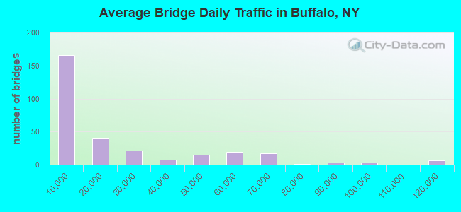
- 6,044,286Total average daily traffic
- 185,043Total average daily truck traffic
- National Bridge Inventory (NBI) Registered Bridges for Buffalo
- No street view available for this location
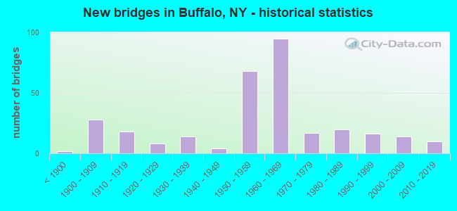
- New bridges - historical statistics
- 2Before 1900
- 281900-1909
- 181910-1919
- 81920-1929
- 141930-1939
- 41940-1949
- 681950-1959
- 951960-1969
- 171970-1979
- 201980-1989
- 161990-1999
- 142000-2009
- 102010-2019
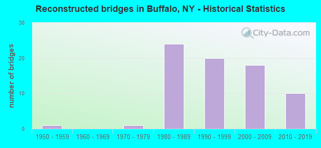
- Reconstructed bridges - Historical Statistics
- 11950-1959
- 01960-1969
- 11970-1979
- 241980-1989
- 201990-1999
- 182000-2009
- 102010-2019

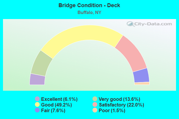
- Bridge Condition - Deck
- 6.1%Excellent
- 13.6%Very good
- 49.2%Good
- 22.0%Satisfactory
- 7.6%Fair
- 1.5%Poor
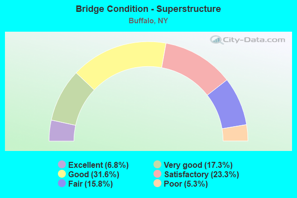
- Bridge Condition - Superstructure
- 6.8%Excellent
- 17.3%Very good
- 31.6%Good
- 23.3%Satisfactory
- 15.8%Fair
- 5.3%Poor
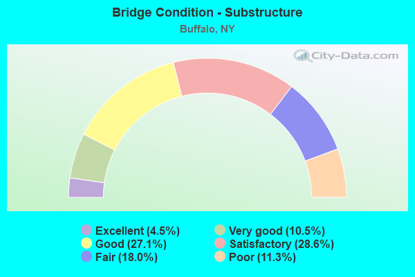
- Bridge Condition - Substructure
- 4.5%Excellent
- 10.5%Very good
- 27.1%Good
- 28.6%Satisfactory
- 18.0%Fair
- 11.3%Poor
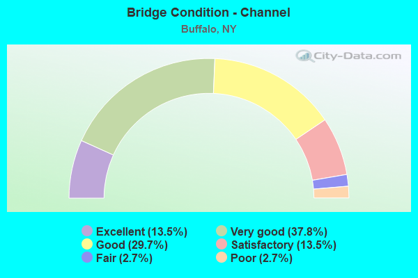
- Bridge Condition - Channel
- 13.5%Excellent
- 37.8%Very good
- 29.7%Good
- 13.5%Satisfactory
- 2.7%Fair
- 2.7%Poor
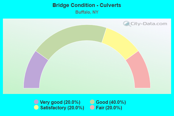
- Bridge Condition - Culverts
- 20.0%Very good
- 40.0%Good
- 20.0%Satisfactory
- 20.0%Fair
Find on map >> Show street view
Structure Number: 505436, Location: 3.0 MI NE JCT RTS 5 + 16 (Lat: 42.923197, Lng: -78.856214), Route carried "on" structure: City street 5, Year Built: 1921, Status: Open, Structure Length: 1.10m (3.61ft), Average Daily Traffic: 16,041 (year 2018), Truck Traffic: 3%, Average Future Daily Traffic: 16,116 (year 2040), Features Intersected: SCAJAQUADA CREEK
Minimum Vertical Clearance: 30+ m (98+ ft), Kilometerpoint: 50.555, Lanes on structure: 6, Base Highway Network: Yes, Owner: State Agenciy, Approaching Roadway Width: 18.3m (60.0ft), Material/Design: Masonry, Design/Construction: Culvert, Number Of Spans In Main Unit: 1, Length of Maximum Span: 9.7m (31.8ft), Curb or Sidewalk Widths: Left: 4.2m (13.8ft), Right: 0.0m
Condition: Channel: Good, Culverts: Fair, Operating Rating: 46.5 metric tons, Method Used To Determine Operating Rating: Field evaluation and documented engineering judgment, Inventory Rating: 20.9 metric tons, Method Used To Determine Inventory Rating: Field evaluation and documented engineering judgment, Structural Evaluation: Somewhat better than minimum adequacy, Waterway Adequacy: Equal to present minimum criteria, Approach Roadway Alignment: Equal to present minimum criteria, Length Of Structure Improvement: 1.09m (3.58ft), Designated Inspection Frequency: Every 24 months, Inspection Date: November 2020, Bridge Improvement Cost: $924,000, Roadway Improvement Cost: $541,000, Total Project Cost: $1,465,000 ( Estimate for 2021)
Find on map >> Show street view
Structure Number: 551217, Location: 0.7 MI W I-90 (Lat: 42.876356, Lng: -78.801358), Route carried "on" structure: City street , Year Built: 2003, Status: Open, Structure Length: 6.43m (21.10ft), Average Daily Traffic: 9,662 (year 2020), Truck Traffic: 12%, Average Future Daily Traffic: 10,203 (year 2040), Design Load: HS 25 or greater, Features Intersected: 190IX, RTE I190, Facility Carried by Structure: S OGDEN ST
Minimum Vertical Clearance: 30+ m (98+ ft), Kilometerpoint: 1.657, Lanes on structure: 2, Lanes under structure: 16, Owner: State Toll Authority, Approaching Roadway Width: 10.4m (34.1ft), Material/Design: Steel continuous, Design/Construction: Stringer/Multi-beam, Number Of Spans In Main Unit: 2, Length of Maximum Span: 31.4m (103.0ft), Curb or Sidewalk Widths: Left: 2.7m (8.9ft), Right: 2.7m (8.9ft), Curb-To-Curb Width: 10.4m (34.1ft), Out-to-Out Width: 16.4m (53.8ft)
Condition: Deck: Very good, Superstructure: Very good, Substructure: Very good, Operating Rating: 98.9 metric tons, Method Used To Determine Operating Rating: Load Factor (LF), Inventory Rating: 59.0 metric tons, Method Used To Determine Inventory Rating: Load Factor (LF), Structural Evaluation: Equal to present desirable criteria, Deck Geometry: Meets minimum limits, Underclear: Meets minimum limits, Approach Roadway Alignment: Equal to present minimum criteria, Length Of Structure Improvement: 6.43m (21.10ft), Designated Inspection Frequency: Every 24 months, Inspection Date: September 2020, Bridge Improvement Cost: $4,076,000, Roadway Improvement Cost: $2,387,000, Total Project Cost: $6,464,000 ( Estimate for 2021), Deck Structure Type: Concrete Cast-file-Place, Wearing Surface/Protective System: Wearing Surface: Integral Concrete, Deck Protection: Galvanized Reinforcing
Find on map >> Show street view
Structure Number: 551218, Location: 1.4 MI W I190 TOLLGATE (Lat: 42.876003, Lng: -78.808517), Route carried "on" structure: City street , Year Built: 1957, Status: Open, Structure Length: 6.07m (19.91ft), Average Daily Traffic: 1,210 (year 2017), Truck Traffic: 5%, Average Future Daily Traffic: 1,694 (year 2037), Design Load: HS 20+Mod, Features Intersected: 190IX NB, RTE I190, Facility Carried by Structure: Weiss Street
Minimum Vertical Clearance: 30+ m (98+ ft), Kilometerpoint: 0.161, Lanes on structure: 2, Lanes under structure: 6, Owner: State Toll Authority, Approaching Roadway Width: 11.0m (36.1ft), Skew: 1 degrees, Material/Design: Steel, Design/Construction: Stringer/Multi-beam, Number Of Spans In Main Unit: 4, Length of Maximum Span: 18.0m (59.1ft), Curb or Sidewalk Widths: Left: 1.5m (4.9ft), Right: 1.5m (4.9ft), Curb-To-Curb Width: 11.0m (36.1ft), Out-to-Out Width: 14.4m (47.2ft)
Condition: Deck: Fair, Superstructure: Fair, Substructure: Poor, Operating Rating: 58.1 metric tons, Method Used To Determine Operating Rating: Load Factor (LF), Inventory Rating: 34.5 metric tons, Method Used To Determine Inventory Rating: Load Factor (LF), Structural Evaluation: Meets minimum limits, Deck Geometry: Equal to present minimum criteria, Underclear: High priority of corrective action, Approach Roadway Alignment: Equal to present minimum criteria, Length Of Structure Improvement: 6.06m (19.88ft), Designated Inspection Frequency: Every 24 months, Inspection Date: September 2020, Bridge Improvement Cost: $3,160,000, Roadway Improvement Cost: $1,850,000, Total Project Cost: $5,010,000 ( Estimate for 2021), Deck Structure Type: Concrete Cast-file-Place, Wearing Surface/Protective System: Wearing Surface: Bituminous
Find on map >> Show street view
Structure Number: 5512199, Location: 0.9 MI E JCT RTS I190< 16 (Lat: 42.869006, Lng: -78.821172), Route carried "on" structure: Interstate 190, Year Built: 1957, Year Reconstructed: 1989, Status: Open, Structure Length: 28.62m (93.90ft), Average Daily Traffic: 42,042 (year 2020), Truck Traffic: 14%, Average Future Daily Traffic: 47,116 (year 2040), Design Load: HS 20+Mod, Features Intersected: BAILEY AVE. (US 6, NORFO
Minimum Vertical Clearance: 30+ m (98+ ft), Kilometerpoint: 3.395, Lanes on structure: 7, Lanes under structure: 3, Base Highway Network: Yes, Owner: State Toll Authority, Approaching Roadway Width: 29.6m (97.1ft), Skew: 24 degrees, Material/Design: Steel, Design/Construction: Stringer/Multi-beam, Number Of Spans In Main Unit: 13, Length of Maximum Span: 40.2m (131.9ft), Curb-To-Curb Width: 30.8m (101.0ft), Out-to-Out Width: 32.7m (107.3ft)
Condition: Deck: Satisfactory, Superstructure: Satisfactory, Substructure: Satisfactory, Operating Rating: 37.6 metric tons, Method Used To Determine Operating Rating: Load and Resistance Factor Rating (LRFR) rating reported by rating factor(RF) method using HL-93 loadings, Inventory Rating: 29.2 metric tons, Method Used To Determine Inventory Rating: Load and Resistance Factor Rating (LRFR) rating reported by rating factor(RF) method using HL-93 loadings, Structural Evaluation: Equal to present minimum criteria, Deck Geometry: Equal to present minimum criteria, Underclear: Meets minimum limits, Approach Roadway Alignment: Equal to present desirable criteria, Length Of Structure Improvement: 28.62m (93.90ft), Designated Inspection Frequency: Every 24 months, Inspection Date: August 2021, Bridge Improvement Cost: $33,030,000, Roadway Improvement Cost: $19,342,000, Total Project Cost: $52,372,000 ( Estimate for 2021), Deck Structure Type: Concrete Cast-file-Place, Wearing Surface/Protective System: Wearing Surface: Integral Concrete, Deck Protection: Epoxy Coated Reinforcing
Find on map >> Show street view
Structure Number: 5512209, Location: 0.5 MI W JCT RTS I190< 16 (Lat: 42.868339, Lng: -78.831936), Route carried "on" structure: Interstate 190, Year Built: 1957, Year Reconstructed: 1989, Status: Open, Structure Length: 3.96m (12.99ft), Average Daily Traffic: 56,174 (year 2020), Truck Traffic: 13%, Average Future Daily Traffic: 62,954 (year 2040), Design Load: HS 20+Mod, Features Intersected: MILTON ST
Minimum Vertical Clearance: 30+ m (98+ ft), Kilometerpoint: 4.425, Lanes on structure: 7, Lanes under structure: 2, Base Highway Network: Yes, Owner: State Toll Authority, Approaching Roadway Width: 28.0m (91.9ft), Skew: 21 degrees, Material/Design: Steel, Design/Construction: Stringer/Multi-beam, Number Of Spans In Main Unit: 3, Length of Maximum Span: 16.5m (54.1ft), Curb-To-Curb Width: 31.1m (102.0ft), Out-to-Out Width: 32.7m (107.3ft)
Condition: Deck: Satisfactory, Superstructure: Satisfactory, Substructure: Satisfactory, Operating Rating: 58.1 metric tons, Method Used To Determine Operating Rating: Load Factor (LF), Inventory Rating: 34.5 metric tons, Method Used To Determine Inventory Rating: Load Factor (LF), Structural Evaluation: Equal to present minimum criteria, Deck Geometry: Equal to present minimum criteria, Underclear: Equal to present minimum criteria, Approach Roadway Alignment: Equal to present desirable criteria, Length Of Structure Improvement: 3.96m (12.99ft), Designated Inspection Frequency: Every 24 months, Inspection Date: September 2021, Bridge Improvement Cost: $4,830,000, Roadway Improvement Cost: $2,828,000, Total Project Cost: $7,658,000 ( Estimate for 2021), Deck Structure Type: Concrete Cast-file-Place, Wearing Surface/Protective System: Wearing Surface: Integral Concrete, Deck Protection: Epoxy Coated Reinforcing
Find on map >> Show street view
Structure Number: 5512219, Location: 1.1 MI W JCT RTS I190< 16 (Lat: 42.868944, Lng: -78.835428), Route carried "on" structure: Interstate 190, Year Built: 1957, Year Reconstructed: 1989, Status: Open, Structure Length: 4.45m (14.60ft), Average Daily Traffic: 56,174 (year 2020), Truck Traffic: 13%, Average Future Daily Traffic: 62,954 (year 2040), Design Load: HS 20+Mod, Features Intersected: BABCOCK ST
Minimum Vertical Clearance: 30+ m (98+ ft), Kilometerpoint: 4.714, Lanes on structure: 6, Lanes under structure: 2, Base Highway Network: Yes, Owner: State Toll Authority, Approaching Roadway Width: 29.3m (96.1ft), Skew: 21 degrees, Material/Design: Steel, Design/Construction: Stringer/Multi-beam, Number Of Spans In Main Unit: 3, Length of Maximum Span: 21.6m (70.9ft), Curb-To-Curb Width: 29.3m (96.1ft), Out-to-Out Width: 31.3m (102.7ft)
Condition: Deck: Good, Superstructure: Satisfactory, Substructure: Satisfactory, Operating Rating: 58.1 metric tons, Method Used To Determine Operating Rating: Load Factor (LF), Inventory Rating: 34.5 metric tons, Method Used To Determine Inventory Rating: Load Factor (LF), Structural Evaluation: Equal to present minimum criteria, Deck Geometry: Better than present minimum criteria, Underclear: Better than present minimum criteria, Approach Roadway Alignment: Equal to present desirable criteria, Length Of Structure Improvement: 4.45m (14.60ft), Designated Inspection Frequency: Every 24 months, Inspection Date: September 2021, Bridge Improvement Cost: $5,425,000, Roadway Improvement Cost: $3,177,000, Total Project Cost: $8,602,000 ( Estimate for 2021), Deck Structure Type: Concrete Cast-file-Place, Wearing Surface/Protective System: Wearing Surface: Integral Concrete, Deck Protection: Epoxy Coated Reinforcing
Find on map >> Show street view
Structure Number: 5512229, Location: 1.7 MI WNW JCT RTSI190<16 (Lat: 42.869678, Lng: -78.839578), Route carried "on" structure: Interstate 190, Year Built: 1957, Year Reconstructed: 1989, Status: Open, Structure Length: 4.02m (13.19ft), Average Daily Traffic: 56,174 (year 2020), Truck Traffic: 13%, Average Future Daily Traffic: 62,954 (year 2040), Design Load: HS 20+Mod, Features Intersected: PEABODY ST
Minimum Vertical Clearance: 30+ m (98+ ft), Kilometerpoint: 4.747, Lanes on structure: 6, Lanes under structure: 2, Base Highway Network: Yes, Owner: State Toll Authority, Approaching Roadway Width: 29.6m (97.1ft), Skew: 20 degrees, Material/Design: Steel, Design/Construction: Stringer/Multi-beam, Number Of Spans In Main Unit: 3, Length of Maximum Span: 16.8m (55.1ft), Curb-To-Curb Width: 29.7m (97.4ft), Out-to-Out Width: 31.3m (102.7ft)
Condition: Deck: Good, Superstructure: Fair, Substructure: Poor, Operating Rating: 64.4 metric tons, Method Used To Determine Operating Rating: Load Factor (LF), Inventory Rating: 37.2 metric tons, Method Used To Determine Inventory Rating: Load Factor (LF), Structural Evaluation: Meets minimum limits, Deck Geometry: Superior to present desirable criteria, Underclear: Equal to present minimum criteria, Approach Roadway Alignment: Equal to present desirable criteria, Length Of Structure Improvement: 4.02m (13.19ft), Designated Inspection Frequency: Every 24 months, Inspection Date: October 2021, Bridge Improvement Cost: $4,908,000, Roadway Improvement Cost: $2,874,000, Total Project Cost: $7,783,000 ( Estimate for 2021), Deck Structure Type: Concrete Cast-file-Place, Wearing Surface/Protective System: Wearing Surface: Integral Concrete, Deck Protection: Epoxy Coated Reinforcing
Find on map >> Show street view
Structure Number: 5512239, Location: .3 MI E 190I EXIT N4 (Lat: 42.870308, Lng: -78.843094), Route carried "on" structure: Interstate 190, Year Built: 1957, Year Reconstructed: 1989, Status: Open, Structure Length: 17.43m (57.19ft), Average Daily Traffic: 56,174 (year 2020), Truck Traffic: 13%, Average Future Daily Traffic: 62,954 (year 2040), Design Load: HS 20+Mod, Features Intersected: SELKIRK ST, CSX/AMTRAK,
Minimum Vertical Clearance: 30+ m (98+ ft), Kilometerpoint: 5.229, Lanes on structure: 7, Lanes under structure: 2, Base Highway Network: Yes, Owner: State Toll Authority, Approaching Roadway Width: 31.1m (102.0ft), Skew: 20 degrees, Material/Design: Steel, Design/Construction: Stringer/Multi-beam, Number Of Spans In Main Unit: 7, Length of Maximum Span: 31.4m (103.0ft), Curb-To-Curb Width: 31.1m (102.0ft), Out-to-Out Width: 32.7m (107.3ft)
Condition: Deck: Good, Superstructure: Good, Substructure: Good, Operating Rating: 71.7 metric tons, Method Used To Determine Operating Rating: Load Factor (LF), Inventory Rating: 42.6 metric tons, Method Used To Determine Inventory Rating: Load Factor (LF), Structural Evaluation: Better than present minimum criteria, Deck Geometry: Equal to present minimum criteria, Underclear: Somewhat better than minimum adequacy, Approach Roadway Alignment: Equal to present desirable criteria, Length Of Structure Improvement: 17.43m (57.19ft), Designated Inspection Frequency: Every 24 months, Inspection Date: July 2020, Bridge Improvement Cost: $19,253,000, Roadway Improvement Cost: $11,275,000, Total Project Cost: $30,528,000 ( Estimate for 2021), Deck Structure Type: Concrete Cast-file-Place, Wearing Surface/Protective System: Wearing Surface: Integral Concrete, Deck Protection: Epoxy Coated Reinforcing
Find on map >> Show street view
Structure Number: 5512249, Location: 2.4 MI WNW JCT RTSI190<16 (Lat: 42.870733, Lng: -78.845250), Route carried "on" structure: Interstate 190, Year Built: 1957, Year Reconstructed: 1989, Status: Open, Structure Length: 5.03m (16.50ft), Average Daily Traffic: 56,174 (year 2020), Truck Traffic: 13%, Average Future Daily Traffic: 62,954 (year 2040), Design Load: HS 20+Mod, Features Intersected: SMITH ST
Minimum Vertical Clearance: 30+ m (98+ ft), Kilometerpoint: 5.535, Lanes on structure: 6, Lanes under structure: 2, Base Highway Network: Yes, Owner: State Toll Authority, Approaching Roadway Width: 33.5m (109.9ft), Skew: 20 degrees, Material/Design: Steel, Design/Construction: Stringer/Multi-beam, Number Of Spans In Main Unit: 3, Length of Maximum Span: 25.3m (83.0ft), Curb-To-Curb Width: 32.7m (107.3ft), Out-to-Out Width: 33.9m (111.2ft)
Condition: Deck: Good, Superstructure: Fair, Substructure: Satisfactory, Operating Rating: 80.4 metric tons, Method Used To Determine Operating Rating: Field evaluation and documented engineering judgment, Inventory Rating: 32.7 metric tons, Method Used To Determine Inventory Rating: Field evaluation and documented engineering judgment, Structural Evaluation: Somewhat better than minimum adequacy, Deck Geometry: Superior to present desirable criteria, Underclear: Meets minimum limits, Approach Roadway Alignment: Equal to present desirable criteria, Length Of Structure Improvement: 5.02m (16.47ft), Designated Inspection Frequency: Every 24 months, Inspection Date: May 2020, Bridge Improvement Cost: $6,023,000, Roadway Improvement Cost: $3,527,000, Total Project Cost: $9,550,000 ( Estimate for 2021), Deck Structure Type: Concrete Cast-file-Place, Wearing Surface/Protective System: Wearing Surface: Integral Concrete, Deck Protection: Epoxy Coated Reinforcing
Find on map >> Show street view
Structure Number: 5512259, Location: 2.9 MI WNW JCT RTSI190<16 (Lat: 42.871703, Lng: -78.848533), Route carried "on" structure: Interstate 190, Year Built: 1959, Year Reconstructed: 1992, Status: Open, Structure Length: 5.36m (17.59ft), Average Daily Traffic: 52,360 (year 2020), Truck Traffic: 12%, Average Future Daily Traffic: 58,679 (year 2040), Design Load: HS 20+Mod, Features Intersected: ERIE LACK RR (ABD)
Minimum Vertical Clearance: 30+ m (98+ ft), Kilometerpoint: 5.808, Lanes on structure: 7, Base Highway Network: Yes, Owner: State Toll Authority, Approaching Roadway Width: 32.6m (107.0ft), Skew: 22 degrees, Material/Design: Steel, Design/Construction: Stringer/Multi-beam, Number Of Spans In Main Unit: 3, Length of Maximum Span: 20.4m (66.9ft), Curb-To-Curb Width: 31.1m (102.0ft), Out-to-Out Width: 32.7m (107.3ft)
Condition: Deck: Satisfactory, Superstructure: Satisfactory, Substructure: Fair, Operating Rating: 88.0 metric tons, Method Used To Determine Operating Rating: Load Factor (LF), Inventory Rating: 52.6 metric tons, Method Used To Determine Inventory Rating: Load Factor (LF), Structural Evaluation: Somewhat better than minimum adequacy, Deck Geometry: Equal to present minimum criteria, Approach Roadway Alignment: Equal to present desirable criteria, Length Of Structure Improvement: 5.36m (17.59ft), Designated Inspection Frequency: Every 24 months, Inspection Date: June 2021, Bridge Improvement Cost: $6,493,000, Roadway Improvement Cost: $3,802,000, Total Project Cost: $10,296,000 ( Estimate for 2021), Deck Structure Type: Concrete Cast-file-Place, Wearing Surface/Protective System: Wearing Surface: Integral Concrete, Deck Protection: Epoxy Coated Reinforcing
Find on map >> Show street view
Structure Number: 5512269, Location: 3.3 MI WNW JCT I190/SH 16 (Lat: 42.872314, Lng: -78.851667), Route carried "on" structure: Interstate 190, Year Built: 1959, Year Reconstructed: 1992, Status: Open, Structure Length: 4.15m (13.62ft), Average Daily Traffic: 52,360 (year 2020), Truck Traffic: 12%, Average Future Daily Traffic: 58,679 (year 2040), Design Load: HS 20+Mod, Features Intersected: VAN RENSSELAER ST
Minimum Vertical Clearance: 30+ m (98+ ft), Kilometerpoint: 6.098, Lanes on structure: 6, Lanes under structure: 2, Base Highway Network: Yes, Owner: State Toll Authority, Approaching Roadway Width: 29.9m (98.1ft), Skew: 20 degrees, Material/Design: Steel, Design/Construction: Stringer/Multi-beam, Number Of Spans In Main Unit: 3, Length of Maximum Span: 15.8m (51.8ft), Curb-To-Curb Width: 29.7m (97.4ft), Out-to-Out Width: 31.3m (102.7ft)
Condition: Deck: Satisfactory, Superstructure: Fair, Substructure: Satisfactory, Operating Rating: 53.5 metric tons, Method Used To Determine Operating Rating: Load Factor (LF), Inventory Rating: 31.8 metric tons, Method Used To Determine Inventory Rating: Load Factor (LF), Structural Evaluation: Somewhat better than minimum adequacy, Deck Geometry: Superior to present desirable criteria, Underclear: Equal to present minimum criteria, Approach Roadway Alignment: Equal to present desirable criteria, Length Of Structure Improvement: 4.14m (13.58ft), Designated Inspection Frequency: Every 24 months, Inspection Date: September 2021, Bridge Improvement Cost: $4,907,000, Roadway Improvement Cost: $2,873,000, Total Project Cost: $7,780,000 ( Estimate for 2021), Deck Structure Type: Concrete Cast-file-Place, Wearing Surface/Protective System: Wearing Surface: Integral Concrete, Deck Protection: Epoxy Coated Reinforcing
Find on map >> Show street view
Structure Number: 5512279, Location: 3.8 MI WNW JCT RTSI190<16 (Lat: 42.872850, Lng: -78.855164), Route carried "on" structure: Interstate 190, Year Built: 1957, Year Reconstructed: 1991, Status: Open, Structure Length: 7.92m (25.98ft), Average Daily Traffic: 52,360 (year 2020), Truck Traffic: 12%, Average Future Daily Traffic: 58,679 (year 2040), Design Load: HS 20+Mod, Features Intersected: CSX Railroad
Minimum Vertical Clearance: 30+ m (98+ ft), Kilometerpoint: 6.356, Lanes on structure: 6, Base Highway Network: Yes, Owner: State Toll Authority, Approaching Roadway Width: 29.0m (95.1ft), Skew: 22 degrees, Material/Design: Steel, Design/Construction: Stringer/Multi-beam, Number Of Spans In Main Unit: 4, Length of Maximum Span: 25.9m (85.0ft), Curb-To-Curb Width: 29.7m (97.4ft), Out-to-Out Width: 31.3m (102.7ft)
Condition: Deck: Good, Superstructure: Good, Substructure: Satisfactory, Operating Rating: 95.3 metric tons, Method Used To Determine Operating Rating: Load Factor (LF), Inventory Rating: 57.2 metric tons, Method Used To Determine Inventory Rating: Load Factor (LF), Structural Evaluation: Equal to present minimum criteria, Deck Geometry: Superior to present desirable criteria, Underclear: Meets minimum limits, Approach Roadway Alignment: Equal to present desirable criteria, Length Of Structure Improvement: 7.92m (25.98ft), Designated Inspection Frequency: Every 24 months, Inspection Date: September 2021, Bridge Improvement Cost: $8,799,000, Roadway Improvement Cost: $5,152,000, Total Project Cost: $13,951,000 ( Estimate for 2021), Deck Structure Type: Concrete Cast-file-Place, Wearing Surface/Protective System: Wearing Surface: Integral Concrete, Deck Protection: Epoxy Coated Reinforcing
Find on map >> Show street view
Structure Number: 5512289, Location: 4.1 MI WNW JCT RTSI190<16 (Lat: 42.873272, Lng: -78.857531), Route carried "on" structure: Interstate 190, Year Built: 1957, Status: Open, Structure Length: 4.82m (15.81ft), Average Daily Traffic: 61,587 (year 2020), Truck Traffic: 12%, Average Future Daily Traffic: 69,020 (year 2040), Design Load: HS 20+Mod, Features Intersected: HAMBURG ST
Minimum Vertical Clearance: 30+ m (98+ ft), Kilometerpoint: 6.581, Lanes on structure: 6, Lanes under structure: 2, Base Highway Network: Yes, Owner: State Toll Authority, Approaching Roadway Width: 31.7m (104.0ft), Skew: 20 degrees, Material/Design: Steel, Design/Construction: Stringer/Multi-beam, Number Of Spans In Main Unit: 3, Length of Maximum Span: 21.0m (68.9ft), Curb-To-Curb Width: 31.1m (102.0ft), Out-to-Out Width: 32.7m (107.3ft)
Condition: Deck: Satisfactory, Superstructure: Good, Substructure: Good, Operating Rating: 81.3 metric tons, Method Used To Determine Operating Rating: Field evaluation and documented engineering judgment, Inventory Rating: 32.7 metric tons, Method Used To Determine Inventory Rating: Field evaluation and documented engineering judgment, Structural Evaluation: Better than present minimum criteria, Deck Geometry: Superior to present desirable criteria, Underclear: Equal to present minimum criteria, Approach Roadway Alignment: Equal to present desirable criteria, Length Of Structure Improvement: 4.81m (15.78ft), Designated Inspection Frequency: Every 24 months, Inspection Date: April 2020, Bridge Improvement Cost: $5,836,000, Roadway Improvement Cost: $3,418,000, Total Project Cost: $9,254,000 ( Estimate for 2021), Deck Structure Type: Concrete Cast-file-Place, Wearing Surface/Protective System: Wearing Surface: Integral Concrete
Find on map >> Show street view
Structure Number: 551229, Location: 0.8 MI E JCT RTS I190 < 5 (Lat: 42.875517, Lng: -78.863306), Route carried "on" structure: City street , Year Built: 1960, Status: Open, Structure Length: 25.30m (83.01ft), Average Daily Traffic: 2,472 (year 2020), Truck Traffic: 4%, Average Future Daily Traffic: 2,610 (year 2040), Design Load: HS 20+Mod, Features Intersected: 190IX, CSXT/AMTRAK, RTE, Facility Carried by Structure: LOUISIANA ST
Minimum Vertical Clearance: 30+ m (98+ ft), Kilometerpoint: 1.432, Lanes on structure: 4, Lanes under structure: 11, Owner: State Toll Authority, Approaching Roadway Width: 13.4m (44.0ft), Material/Design: Steel, Design/Construction: Stringer/Multi-beam, Number Of Spans In Main Unit: 11, Length of Maximum Span: 34.1m (111.9ft), Curb or Sidewalk Widths: Left: 1.5m (4.9ft), Right: 1.5m (4.9ft), Curb-To-Curb Width: 13.4m (44.0ft), Out-to-Out Width: 17.1m (56.1ft)
Condition: Deck: Poor, Superstructure: Poor, Substructure: Poor, Operating Rating: 49.0 metric tons, Method Used To Determine Operating Rating: Load Factor (LF), Inventory Rating: 29.0 metric tons, Method Used To Determine Inventory Rating: Load Factor (LF), Structural Evaluation: Meets minimum limits, Deck Geometry: High priority of replacement, Underclear: High priority of corrective action, Approach Roadway Alignment: Equal to present desirable criteria, Length Of Structure Improvement: 25.29m (82.97ft), Designated Inspection Frequency: Every 12 months, Critical Feature Inspection Frequency: Every 12 months, Inspection Date: December 2021, Critical Feature Inspection Date: December 2021, Bridge Improvement Cost: $15,300,000, Roadway Improvement Cost: $8,960,000, Total Project Cost: $24,260,000 ( Estimate for 2021), Deck Structure Type: Concrete Cast-file-Place, Wearing Surface/Protective System: Wearing Surface: Bituminous
Find on map >> Show street view
Structure Number: 551256, Location: 1.4 MI SSE PEACE BRIDGE (Lat: 42.898383, Lng: -78.897922), Route carried "on" structure: City street , Year Built: 2016, Status: Open, Structure Length: 6.17m (20.24ft), Average Daily Traffic: 6,937 (year 2019), Truck Traffic: 3%, Average Future Daily Traffic: 9,712 (year 2039), Design Load: HL 93, Features Intersected: RTE I190, CSX /AMTRAK, Facility Carried by Structure: PORTER AVENUE
Minimum Vertical Clearance: 30+ m (98+ ft), Kilometerpoint: 0.338, Lanes on structure: 2, Lanes under structure: 8, Owner: State Toll Authority, Approaching Roadway Width: 12.8m (42.0ft), Skew: 20 degrees, Material/Design: Steel, Design/Construction: Stringer/Multi-beam, Number Of Spans In Main Unit: 3, Length of Maximum Span: 21.3m (69.9ft), Curb or Sidewalk Widths: Left: 0.0m, Right: 3.7m (12.1ft), Curb-To-Curb Width: 12.8m (42.0ft), Out-to-Out Width: 17.2m (56.4ft)
Condition: Deck: Excellent, Superstructure: Excellent, Substructure: Excellent, Operating Rating: 68.0 metric tons, Method Used To Determine Operating Rating: Load Factor (LF), Inventory Rating: 40.8 metric tons, Method Used To Determine Inventory Rating: Load Factor (LF), Structural Evaluation: Superior to present desirable criteria, Deck Geometry: Somewhat better than minimum adequacy, Underclear: High priority of corrective action, Approach Roadway Alignment: Equal to present minimum criteria, Length Of Structure Improvement: 6.17m (20.24ft), Designated Inspection Frequency: Every 24 months, Inspection Date: October 2020, Bridge Improvement Cost: $5,864,000, Roadway Improvement Cost: $3,434,000, Total Project Cost: $9,298,000 ( Estimate for 2021), Deck Structure Type: Concrete Cast-file-Place, Wearing Surface/Protective System: Wearing Surface: Integral Concrete, Deck Protection: Galvanized Reinforcing
Find on map >> Show street view
Structure Number: 551257, Location: 1.3 MI SSE OF PEACE BRIDG (Lat: 42.899433, Lng: -78.898292), Route carried "on" structure: Ramp Interstate , Year Built: 1972, Year Reconstructed: 1994, Status: Open, Structure Length: 4.33m (14.21ft), Average Daily Traffic: 7,294 (year 2019), Truck Traffic: 18%, Average Future Daily Traffic: 8,174 (year 2040), Design Load: HS 20+Mod, Features Intersected: 190IX NB OFF RAMP 'N' TO, Facility Carried by Structure: PORTER AVE RAMP 'P
Minimum Vertical Clearance: 30+ m (98+ ft), Kilometerpoint: 0.097, Lanes on structure: 1, Lanes under structure: 2, Owner: State Toll Authority, Approaching Roadway Width: 8.5m (27.9ft), Skew: 5 degrees, Material/Design: Steel, Design/Construction: Stringer/Multi-beam, Number Of Spans In Main Unit: 1, Length of Maximum Span: 39.9m (130.9ft), Curb-To-Curb Width: 7.9m (25.9ft), Out-to-Out Width: 8.8m (28.9ft)
Condition: Deck: Satisfactory, Superstructure: Good, Substructure: Fair, Inventory Rating: 32.7 metric tons, Method Used To Determine Inventory Rating: Field evaluation and documented engineering judgment, Structural Evaluation: Somewhat better than minimum adequacy, Deck Geometry: Equal to present desirable criteria, Underclear: Meets minimum limits, Approach Roadway Alignment: Equal to present minimum criteria, Length Of Structure Improvement: 4.32m (14.17ft), Designated Inspection Frequency: Every 24 months, Inspection Date: September 2021, Bridge Improvement Cost: $2,878,000, Roadway Improvement Cost: $1,685,000, Total Project Cost: $4,563,000 ( Estimate for 2021), Deck Structure Type: Concrete Cast-file-Place, Wearing Surface/Protective System: Wearing Surface: Latex Concrete
Find on map >> Show street view
Structure Number: 5512589, Location: 1.2 MI SSE PEACE BRIDGE (Lat: 42.902639, Lng: -78.900817), Route carried "on" structure: Interstate 190, Year Built: 1957, Year Reconstructed: 1992, Status: Open, Structure Length: 9.30m (30.51ft), Average Daily Traffic: 57,524 (year 2020), Truck Traffic: 7%, Average Future Daily Traffic: 64,467 (year 2040), Design Load: HS 20+Mod, Features Intersected: Busti Ave. Access, CSX/A
Minimum Vertical Clearance: 30+ m (98+ ft), Kilometerpoint: 11.585, Lanes on structure: 4, Lanes under structure: 2, Base Highway Network: Yes, Toll: On toll road, Owner: State Toll Authority, Approaching Roadway Width: 26.8m (87.9ft), Skew: 27 degrees, Material/Design: Steel, Design/Construction: Stringer/Multi-beam, Number Of Spans In Main Unit: 3, Length of Maximum Span: 43.9m (144.0ft), Curb-To-Curb Width: 21.6m (70.9ft), Out-to-Out Width: 22.9m (75.1ft)
Condition: Deck: Satisfactory, Superstructure: Fair, Substructure: Satisfactory, Operating Rating: 49.0 metric tons, Method Used To Determine Operating Rating: Load Factor (LF), Inventory Rating: 32.7 metric tons, Method Used To Determine Inventory Rating: Load Factor (LF), Structural Evaluation: Somewhat better than minimum adequacy, Deck Geometry: Better than present minimum criteria, Underclear: High priority of corrective action, Approach Roadway Alignment: Equal to present desirable criteria, Length Of Structure Improvement: 9.29m (30.48ft), Designated Inspection Frequency: Every 24 months, Critical Feature Inspection Frequency: Every 24 months, Inspection Date: November 2020, Critical Feature Inspection Date: November 2020, Bridge Improvement Cost: $13,349,000, Roadway Improvement Cost: $7,817,000, Total Project Cost: $21,166,000 ( Estimate for 2021), Deck Structure Type: Concrete Cast-file-Place, Wearing Surface/Protective System: Wearing Surface: Integral Concrete, Deck Protection: Epoxy Coated Reinforcing
Find on map >> Show street view
Structure Number: 5512599, Location: 0.4 MI S PEACE BRIDGE (Lat: 42.904106, Lng: -78.901200), Route carried "on" structure: Interstate 190, Year Built: 1994, Status: Open, Structure Length: 1.40m (4.59ft), Average Daily Traffic: 57,524 (year 2020), Truck Traffic: 7%, Average Future Daily Traffic: 64,467 (year 2040), Design Load: HS 25 or greater, Features Intersected: PUMP STATION ACCESS RD
Minimum Vertical Clearance: 30+ m (98+ ft), Kilometerpoint: 11.778, Lanes on structure: 4, Lanes under structure: 1, Base Highway Network: Yes, Owner: State Toll Authority, Approaching Roadway Width: 10.4m (34.1ft), Skew: 22 degrees, Material/Design: Steel, Design/Construction: Stringer/Multi-beam, Number Of Spans In Main Unit: 1, Length of Maximum Span: 13.1m (43.0ft), Curb-To-Curb Width: 20.9m (68.6ft), Out-to-Out Width: 22.3m (73.2ft)
Condition: Deck: Good, Superstructure: Good, Substructure: Satisfactory, Operating Rating: 68.9 metric tons, Method Used To Determine Operating Rating: Load Factor (LF), Inventory Rating: 42.6 metric tons, Method Used To Determine Inventory Rating: Load Factor (LF), Structural Evaluation: Equal to present minimum criteria, Deck Geometry: Better than present minimum criteria, Underclear: Meets minimum limits, Approach Roadway Alignment: Equal to present desirable criteria, Length Of Structure Improvement: 1.40m (4.59ft), Designated Inspection Frequency: Every 24 months, Inspection Date: May 2020, Bridge Improvement Cost: $3,556,000, Roadway Improvement Cost: $2,082,000, Total Project Cost: $5,638,000 ( Estimate for 2021), Deck Structure Type: Concrete Cast-file-Place, Wearing Surface/Protective System: Wearing Surface: Integral Concrete, Deck Protection: Epoxy Coated Reinforcing
Find on map >> Show street view
Structure Number: 5512609, Location: 2.6 MI S JCT RTS I190<198 (Lat: 42.915183, Lng: -78.901514), Route carried "on" structure: Interstate 190, Year Built: 1957, Year Reconstructed: 1994, Status: Open, Structure Length: 1.77m (5.81ft), Average Daily Traffic: 57,524 (year 2020), Truck Traffic: 7%, Average Future Daily Traffic: 64,467 (year 2040), Design Load: HS 20+Mod, Features Intersected: WEST FERRY ST
Minimum Vertical Clearance: 30+ m (98+ ft), Kilometerpoint: 13.017, Lanes on structure: 4, Lanes under structure: 2, Base Highway Network: Yes, Toll: On toll road, Owner: State Toll Authority, Approaching Roadway Width: 18.9m (62.0ft), Skew: 20 degrees, Material/Design: Steel, Design/Construction: Stringer/Multi-beam, Number Of Spans In Main Unit: 1, Length of Maximum Span: 16.5m (54.1ft), Curb-To-Curb Width: 17.9m (58.7ft), Out-to-Out Width: 19.8m (65.0ft)
Condition: Deck: Good, Superstructure: Good, Substructure: Good, Operating Rating: 48.3 metric tons, Method Used To Determine Operating Rating: Load and Resistance Factor Rating (LRFR) rating reported by rating factor(RF) method using HL-93 loadings, Inventory Rating: 37.3 metric tons, Method Used To Determine Inventory Rating: Load and Resistance Factor Rating (LRFR) rating reported by rating factor(RF) method using HL-93 loadings, Structural Evaluation: Better than present minimum criteria, Deck Geometry: Meets minimum limits, Underclear: Somewhat better than minimum adequacy, Approach Roadway Alignment: Equal to present desirable criteria, Length Of Structure Improvement: 1.76m (5.77ft), Designated Inspection Frequency: Every 24 months, Inspection Date: August 2020, Bridge Improvement Cost: $2,653,000, Roadway Improvement Cost: $1,554,000, Total Project Cost: $4,207,000 ( Estimate for 2021), Deck Structure Type: Concrete Cast-file-Place, Wearing Surface/Protective System: Wearing Surface: Integral Concrete, Deck Protection: Epoxy Coated Reinforcing
Find on map >> Show street view
Structure Number: 5512619, Location: JCT RTS I190 < 198 (Lat: 42.928944, Lng: -78.898742), Route carried "on" structure: Interstate 190, Year Built: 1957, Status: Open, Structure Length: 20.94m (68.70ft), Average Daily Traffic: 48,735 (year 2019), Truck Traffic: 6%, Average Future Daily Traffic: 54,617 (year 2040), Design Load: HS 20+Mod, Features Intersected: SCAJAQUADA CREEK
Minimum Vertical Clearance: 30+ m (98+ ft), Kilometerpoint: 14.465, Lanes on structure: 4, Base Highway Network: Yes, Toll: On toll road, Owner: State Toll Authority, Approaching Roadway Width: 18.3m (60.0ft), Skew: 20 degrees, Material/Design: Steel continuous, Design/Construction: Stringer/Multi-beam, Number Of Spans In Main Unit: 3, Number Of Approach Spans: 47, Length of Maximum Span: 21.9m (71.9ft), Curb-To-Curb Width: 21.9m (71.9ft), Out-to-Out Width: 23.6m (77.4ft)
Condition: Deck: Good, Superstructure: Satisfactory, Substructure: Fair, Channel: Good, Inventory Rating: 66.2 metric tons, Method Used To Determine Inventory Rating: Load Factor (LF), Structural Evaluation: Somewhat better than minimum adequacy, Deck Geometry: Better than present minimum criteria, Waterway Adequacy: Equal to present desirable criteria, Approach Roadway Alignment: Equal to present desirable criteria, Length Of Structure Improvement: 20.93m (68.67ft), Designated Inspection Frequency: Every 24 months, Underwater Inspection Frequency: Every 60 months, Inspection Date: September 2020, Underwater Inspection Date: November 2020, Bridge Improvement Cost: $17,441,000, Roadway Improvement Cost: $10,214,000, Total Project Cost: $27,655,000 ( Estimate for 2021), Deck Structure Type: Concrete Cast-file-Place, Wearing Surface/Protective System: Wearing Surface: Integral Concrete
Find on map >> Show street view
Structure Number: 5512639, Location: 1.7 MI NW JCT I190 < 198 (Lat: 42.935925, Lng: -78.904228), Route carried "on" structure: Interstate 190, Year Built: 1957, Year Reconstructed: 1992, Status: Open, Structure Length: 4.30m (14.11ft), Average Daily Traffic: 54,461 (year 2020), Truck Traffic: 7%, Average Future Daily Traffic: 61,034 (year 2040), Design Load: HS 20+Mod, Features Intersected: HAMILTON ST
Minimum Vertical Clearance: 30+ m (98+ ft), Kilometerpoint: 15.462, Lanes on structure: 5, Lanes under structure: 2, Base Highway Network: Yes, Owner: State Toll Authority, Approaching Roadway Width: 25.9m (85.0ft), Skew: 20 degrees, Material/Design: Steel, Design/Construction: Stringer/Multi-beam, Number Of Spans In Main Unit: 3, Length of Maximum Span: 21.3m (69.9ft), Curb-To-Curb Width: 24.6m (80.7ft), Out-to-Out Width: 26.6m (87.3ft)
Condition: Deck: Good, Superstructure: Satisfactory, Substructure: Good, Operating Rating: 87.1 metric tons, Method Used To Determine Operating Rating: Load Factor (LF), Inventory Rating: 51.7 metric tons, Method Used To Determine Inventory Rating: Load Factor (LF), Structural Evaluation: Equal to present minimum criteria, Deck Geometry: Better than present minimum criteria, Underclear: High priority of corrective action, Approach Roadway Alignment: Equal to present desirable criteria, Length Of Structure Improvement: 4.29m (14.07ft), Designated Inspection Frequency: Every 24 months, Inspection Date: April 2021, Bridge Improvement Cost: $4,300,000, Roadway Improvement Cost: $2,518,000, Total Project Cost: $6,818,000 ( Estimate for 2021), Deck Structure Type: Concrete Cast-file-Place, Wearing Surface/Protective System: Wearing Surface: Integral Concrete, Deck Protection: Epoxy Coated Reinforcing
Find on map >> Show street view
Structure Number: 5512649, Location: 2.0 MI.NW JCT.I190 & 198 (Lat: 42.937811, Lng: -78.905192), Route carried "on" structure: Interstate 190, Year Built: 1957, Year Reconstructed: 1994, Status: Open, Structure Length: 3.05m (10.01ft), Average Daily Traffic: 54,461 (year 2020), Truck Traffic: 7%, Average Future Daily Traffic: 61,034 (year 2040), Design Load: HS 20+Mod, Features Intersected: AUSTIN ST
Minimum Vertical Clearance: 30+ m (98+ ft), Kilometerpoint: 15.688, Lanes on structure: 5, Lanes under structure: 2, Base Highway Network: Yes, Owner: State Toll Authority, Approaching Roadway Width: 24.4m (80.1ft), Skew: 20 degrees, Material/Design: Steel, Design/Construction: Stringer/Multi-beam, Number Of Spans In Main Unit: 1, Length of Maximum Span: 29.3m (96.1ft), Curb-To-Curb Width: 24.4m (80.1ft), Out-to-Out Width: 26.4m (86.6ft)
Condition: Deck: Good, Superstructure: Good, Substructure: Satisfactory, Operating Rating: 52.8 metric tons, Method Used To Determine Operating Rating: Load and Resistance Factor Rating (LRFR) rating reported by rating factor(RF) method using HL-93 loadings, Inventory Rating: 40.8 metric tons, Method Used To Determine Inventory Rating: Load and Resistance Factor Rating (LRFR) rating reported by rating factor(RF) method using HL-93 loadings, Structural Evaluation: Equal to present minimum criteria, Deck Geometry: Equal to present minimum criteria, Underclear: Meets minimum limits, Approach Roadway Alignment: Equal to present desirable criteria, Length Of Structure Improvement: 3.04m (9.97ft), Designated Inspection Frequency: Every 24 months, Inspection Date: July 2020, Bridge Improvement Cost: $3,883,000, Roadway Improvement Cost: $2,274,000, Total Project Cost: $6,156,000 ( Estimate for 2021), Deck Structure Type: Concrete Cast-file-Place, Wearing Surface/Protective System: Wearing Surface: Integral Concrete, Deck Protection: Epoxy Coated Reinforcing
Find on map >> Show street view
Structure Number: 5512659, Location: 2.5 MI NW JCT I190 < 198 (Lat: 42.940414, Lng: -78.906475), Route carried "on" structure: Interstate 190, Year Built: 1957, Year Reconstructed: 1992, Status: Open, Structure Length: 4.11m (13.48ft), Average Daily Traffic: 46,079 (year 2020), Truck Traffic: 7%, Average Future Daily Traffic: 51,640 (year 2040), Design Load: HS 20+Mod, Features Intersected: HERTEL AVE
Minimum Vertical Clearance: 30+ m (98+ ft), Kilometerpoint: 15.993, Lanes on structure: 4, Lanes under structure: 3, Base Highway Network: Yes, Owner: State Toll Authority, Approaching Roadway Width: 18.9m (62.0ft), Skew: 20 degrees, Material/Design: Steel, Design/Construction: Stringer/Multi-beam, Number Of Spans In Main Unit: 3, Length of Maximum Span: 19.5m (64.0ft), Curb-To-Curb Width: 21.0m (68.9ft), Out-to-Out Width: 22.9m (75.1ft)
Condition: Deck: Good, Superstructure: Satisfactory, Substructure: Good, Operating Rating: 79.9 metric tons, Method Used To Determine Operating Rating: Field evaluation and documented engineering judgment, Inventory Rating: 32.7 metric tons, Method Used To Determine Inventory Rating: Field evaluation and documented engineering judgment, Structural Evaluation: Equal to present minimum criteria, Deck Geometry: Better than present minimum criteria, Underclear: Meets minimum limits, Approach Roadway Alignment: Equal to present desirable criteria, Length Of Structure Improvement: 4.11m (13.48ft), Designated Inspection Frequency: Every 24 months, Inspection Date: May 2020, Bridge Improvement Cost: $3,580,000, Roadway Improvement Cost: $2,097,000, Total Project Cost: $5,677,000 ( Estimate for 2021), Deck Structure Type: Concrete Cast-file-Place, Wearing Surface/Protective System: Wearing Surface: Integral Concrete, Deck Protection: Epoxy Coated Reinforcing
Find on map >> Show street view
Structure Number: 5512669, Location: 3.1 MI NW JCT I190 < 198 (Lat: 42.943636, Lng: -78.907994), Route carried "on" structure: Interstate 190, Year Built: 1957, Status: Open, Structure Length: 6.98m (22.90ft), Average Daily Traffic: 46,079 (year 2020), Truck Traffic: 7%, Average Future Daily Traffic: 51,640 (year 2040), Design Load: HS 20+Mod, Features Intersected: ONTARIO ST EXIT RAMP, MA
Minimum Vertical Clearance: 30+ m (98+ ft), Kilometerpoint: 16.347, Lanes on structure: 4, Lanes under structure: 3, Base Highway Network: Yes, Owner: State Toll Authority, Approaching Roadway Width: 18.3m (60.0ft), Skew: 20 degrees, Material/Design: Steel, Design/Construction: Stringer/Multi-beam, Number Of Spans In Main Unit: 4, Length of Maximum Span: 17.3m (56.8ft), Curb-To-Curb Width: 20.4m (66.9ft), Out-to-Out Width: 22.9m (75.1ft)
Condition: Deck: Good, Superstructure: Fair, Substructure: Satisfactory, Operating Rating: 83.5 metric tons, Method Used To Determine Operating Rating: Field evaluation and documented engineering judgment, Inventory Rating: 32.7 metric tons, Method Used To Determine Inventory Rating: Field evaluation and documented engineering judgment, Structural Evaluation: Somewhat better than minimum adequacy, Deck Geometry: Equal to present minimum criteria, Underclear: High priority of corrective action, Approach Roadway Alignment: Equal to present desirable criteria, Length Of Structure Improvement: 6.97m (22.87ft), Designated Inspection Frequency: Every 24 months, Inspection Date: May 2020, Bridge Improvement Cost: $7,889,000, Roadway Improvement Cost: $4,620,000, Total Project Cost: $12,509,000 ( Estimate for 2021), Deck Structure Type: Concrete Cast-file-Place, Wearing Surface/Protective System: Wearing Surface: Integral Concrete
Find on map >> Show street view
Structure Number: 5512679, Location: 3.4 MI.NN JCT.I190 & 198 (Lat: 42.945058, Lng: -78.908597), Route carried "on" structure: Interstate 190, Year Built: 1957, Year Reconstructed: 1994, Status: Open, Structure Length: 2.74m (8.99ft), Average Daily Traffic: 46,079 (year 2020), Truck Traffic: 7%, Average Future Daily Traffic: 51,640 (year 2040), Design Load: HS 20+Mod, Features Intersected: BLACK ROCK HARBOR RD, CO
Minimum Vertical Clearance: 30+ m (98+ ft), Kilometerpoint: 16.541, Lanes on structure: 4, Lanes under structure: 2, Base Highway Network: Yes, Owner: State Toll Authority, Approaching Roadway Width: 18.9m (62.0ft), Skew: 20 degrees, Material/Design: Steel, Design/Construction: Stringer/Multi-beam, Number Of Spans In Main Unit: 1, Length of Maximum Span: 26.2m (86.0ft), Curb-To-Curb Width: 21.0m (68.9ft), Out-to-Out Width: 22.9m (75.1ft)
Condition: Deck: Good, Superstructure: Good, Substructure: Satisfactory, Channel: Excellent, Operating Rating: 97.1 metric tons, Method Used To Determine Operating Rating: Load Factor (LF), Inventory Rating: 58.1 metric tons, Method Used To Determine Inventory Rating: Load Factor (LF), Structural Evaluation: Equal to present minimum criteria, Deck Geometry: Better than present minimum criteria, Underclear: Somewhat better than minimum adequacy, Waterway Adequacy: Superior to present desirable criteria, Approach Roadway Alignment: Equal to present desirable criteria, Length Of Structure Improvement: 2.74m (8.99ft), Designated Inspection Frequency: Every 24 months, Inspection Date: May 2020, Bridge Improvement Cost: $2,652,000, Roadway Improvement Cost: $1,553,000, Total Project Cost: $4,205,000 ( Estimate for 2021), Deck Structure Type: Concrete Cast-file-Place, Wearing Surface/Protective System: Wearing Surface: Integral Concrete, Deck Protection: Epoxy Coated Reinforcing
Find on map >> Show street view
Structure Number: 551629, Location: 0.6 m N JCT PRTR AV &I190 (Lat: 42.906281, Lng: -78.901219), Route carried "on" structure: Other road 955, Year Built: 1927, Year Reconstructed: 2019, Status: Open, Structure Length: 121.86m (399.80ft), Average Daily Traffic: 11,337 (year 2011), Truck Traffic: 28%, Average Future Daily Traffic: 11,390 (year 2040), Design Load: HS 20, Features Intersected: 190IX, RTE I190, NIAGARA
Minimum Vertical Clearance: 5.03m (16.50ft), Kilometerpoint: 0.000, Lanes on structure: 3, Lanes under structure: 4, Base Highway Network: Yes, Toll: Toll bridge, Owner: Local Toll Authority, Approaching Roadway Width: 24.4m (80.1ft), Navigation Control: Yes ( Vertical Clearance: 30.4m (99.7ft), Horizontal Clearance: 45.7m (149.9ft)), Material/Design: Steel, Design/Construction: Arch - Deck, Number Of Spans In Main Unit: 41, Length of Maximum Span: 129.2m (423.9ft), Curb or Sidewalk Widths: Left: 2.1m (6.9ft), Right: 2.4m (7.9ft), Curb-To-Curb Width: 11.1m (36.4ft), Out-to-Out Width: 11.9m (39.0ft)
Condition: Deck: Satisfactory, Superstructure: Satisfactory, Substructure: Satisfactory, Channel: Excellent, Operating Rating: 78.0 metric tons, Method Used To Determine Operating Rating: Load Factor (LF), Inventory Rating: 55.3 metric tons, Method Used To Determine Inventory Rating: Load Factor (LF), Structural Evaluation: Equal to present minimum criteria, Deck Geometry: High priority of replacement, Underclear: High priority of corrective action, Waterway Adequacy: Equal to present desirable criteria, Approach Roadway Alignment: Better than present minimum criteria, Length Of Structure Improvement: 121.85m (399.77ft), Designated Inspection Frequency: Every 24 months, Critical Feature Inspection Frequency: Every 24 months, Underwater Inspection Frequency: Every 60 months, Inspection Date: June 2021, Critical Feature Inspection Date: June 2021, Underwater Inspection Date: September 2020, Bridge Improvement Cost: $60,778,000, Roadway Improvement Cost: $35,592,000, Total Project Cost: $96,370,000 ( Estimate for 2021), Wearing Surface/Protective System: Wearing Surface: Bituminous
Find on map >> Show street view
Structure Number: 5520159, Location: 0.4 MI E INT N6 I 190 (Lat: 42.880303, Lng: -78.878981), Route carried "on" structure: Interstate 190, Year Built: 1959, Year Reconstructed: 1997, Status: Open, Structure Length: 222.44m (729.79ft), Average Daily Traffic: 61,587 (year 2020), Truck Traffic: 15%, Average Future Daily Traffic: 69,020 (year 2040), Design Load: HS 20+Mod, Features Intersected: 190IX SB OFF-RAMP "V" TO
Minimum Vertical Clearance: 4.55m (14.93ft), Kilometerpoint: 7.321, Lanes on structure: 6, Lanes under structure: 31, Base Highway Network: Yes, Owner: State Toll Authority, Approaching Roadway Width: 29.9m (98.1ft), Skew: 20 degrees, Material/Design: Steel continuous, Design/Construction: Stringer/Multi-beam, Number Of Spans In Main Unit: 112, Length of Maximum Span: 30.8m (101.0ft), Curb-To-Curb Width: 29.4m (96.5ft), Out-to-Out Width: 31.3m (102.7ft)
Condition: Deck: Satisfactory, Superstructure: Satisfactory, Substructure: Fair, Operating Rating: 55.3 metric tons, Method Used To Determine Operating Rating: Load Factor (LF), Inventory Rating: 32.7 metric tons, Method Used To Determine Inventory Rating: Load Factor (LF), Structural Evaluation: Somewhat better than minimum adequacy, Deck Geometry: High priority of corrective action, Underclear: High priority of corrective action, Approach Roadway Alignment: Equal to present desirable criteria, Length Of Structure Improvement: 222.44m (729.79ft), Designated Inspection Frequency: Every 24 months, Critical Feature Inspection Frequency: Every 24 months, Inspection Date: December 2021, Critical Feature Inspection Date: December 2021, Bridge Improvement Cost: $226,423,000, Roadway Improvement Cost: $132,594,000, Total Project Cost: $359,017,000 ( Estimate for 2021), Deck Structure Type: Concrete Cast-file-Place, Wearing Surface/Protective System: Wearing Surface: Integral Concrete, Deck Protection: Epoxy Coated Reinforcing
Find on map >> Show street view
Structure Number: 552015A, Location: EXIT N6 OF I190 (Lat: 42.877950, Lng: -78.874425), Route carried "on" structure: Ramp Interstate , Year Built: 1960, Year Reconstructed: 1995, Status: Open, Structure Length: 28.53m (93.60ft), Average Daily Traffic: 1,193 (year 2015), Truck Traffic: 15%, Average Future Daily Traffic: 1,336 (year 2040), Design Load: HS 20+Mod, Features Intersected: 190IX SB OFF-RAMP �V� TO, Facility Carried by Structure: 190IX SB ON-RAMP �
Minimum Vertical Clearance: 4.65m (15.26ft), Kilometerpoint: 0.097, Lanes on structure: 1, Lanes under structure: 2, Owner: State Toll Authority, Approaching Roadway Width: 7.3m (24.0ft), Skew: 1 degrees, Material/Design: Steel, Design/Construction: Stringer/Multi-beam, Number Of Spans In Main Unit: 16, Length of Maximum Span: 26.5m (86.9ft), Curb-To-Curb Width: 7.3m (24.0ft), Out-to-Out Width: 8.3m (27.2ft)
Condition: Deck: Good, Superstructure: Good, Substructure: Good, Operating Rating: 53.5 metric tons, Method Used To Determine Operating Rating: Load Factor (LF), Inventory Rating: 31.8 metric tons, Method Used To Determine Inventory Rating: Load Factor (LF), Structural Evaluation: Better than present minimum criteria, Deck Geometry: Meets minimum limits, Underclear: High priority of corrective action, Approach Roadway Alignment: Equal to present minimum criteria, Length Of Structure Improvement: 28.52m (93.57ft), Designated Inspection Frequency: Every 24 months, Inspection Date: April 2021, Bridge Improvement Cost: $8,401,000, Roadway Improvement Cost: $4,920,000, Total Project Cost: $13,320,000 ( Estimate for 2021), Deck Structure Type: Concrete Cast-file-Place, Wearing Surface/Protective System: Wearing Surface: Integral Concrete, Deck Protection: Epoxy Coated Reinforcing
Find on map >> Show street view
Structure Number: 552015B, Location: EXIT N6 OF I190 (Lat: 42.878589, Lng: -78.872883), Route carried "on" structure: Ramp Interstate , Year Built: 1960, Year Reconstructed: 1995, Status: Open, Structure Length: 29.50m (96.78ft), Average Daily Traffic: 5,696 (year 2015), Truck Traffic: 15%, Average Future Daily Traffic: 6,383 (year 2040), Design Load: HS 20+Mod, Features Intersected: 190IX SB, RTE I190, CSXT, Facility Carried by Structure: 190IX SB ON-RAMP �
Minimum Vertical Clearance: 4.80m (15.75ft), Kilometerpoint: 0.064, Lanes on structure: 1, Lanes under structure: 10, Owner: State Toll Authority, Approaching Roadway Width: 7.9m (25.9ft), Material/Design: Steel, Design/Construction: Stringer/Multi-beam, Number Of Spans In Main Unit: 18, Length of Maximum Span: 23.2m (76.1ft), Curb-To-Curb Width: 9.2m (30.2ft), Out-to-Out Width: 10.1m (33.1ft)
Condition: Deck: Very good, Superstructure: Good, Substructure: Good, Operating Rating: 50.8 metric tons, Method Used To Determine Operating Rating: Load Factor (LF), Inventory Rating: 27.2 metric tons, Method Used To Determine Inventory Rating: Load Factor (LF), Structural Evaluation: Equal to present minimum criteria, Deck Geometry: Meets minimum limits, Underclear: High priority of corrective action, Approach Roadway Alignment: Equal to present minimum criteria, Length Of Structure Improvement: 29.50m (96.78ft), Designated Inspection Frequency: Every 24 months, Inspection Date: April 2021, Bridge Improvement Cost: $10,320,000, Roadway Improvement Cost: $6,043,000, Total Project Cost: $16,363,000 ( Estimate for 2021), Deck Structure Type: Concrete Cast-file-Place, Wearing Surface/Protective System: Wearing Surface: Integral Concrete, Deck Protection: Epoxy Coated Reinforcing
Find on map >> Show street view
Structure Number: 552015C, Location: EXIT N6 OF I190 (Lat: 42.878408, Lng: -78.871839), Route carried "on" structure: Ramp Interstate , Year Built: 1960, Year Reconstructed: 1995, Status: Open, Structure Length: 17.43m (57.19ft), Average Daily Traffic: 8,538 (year 2015), Truck Traffic: 15%, Average Future Daily Traffic: 9,568 (year 2040), Design Load: HS 20+Mod, Features Intersected: EXCHANGE ST, CSXT RR / A, Facility Carried by Structure: 190IX NB OFF-RAMP
Minimum Vertical Clearance: 30+ m (98+ ft), Kilometerpoint: 0.274, Lanes on structure: 2, Lanes under structure: 4, Owner: State Toll Authority, Approaching Roadway Width: 9.8m (32.2ft), Skew: 1 degrees, Material/Design: Steel, Design/Construction: Stringer/Multi-beam, Number Of Spans In Main Unit: 9, Length of Maximum Span: 23.5m (77.1ft), Curb-To-Curb Width: 10.4m (34.1ft), Out-to-Out Width: 11.4m (37.4ft)
Condition: Deck: Very good, Superstructure: Good, Substructure: Good, Operating Rating: 57.2 metric tons, Method Used To Determine Operating Rating: Load Factor (LF), Inventory Rating: 31.8 metric tons, Method Used To Determine Inventory Rating: Load Factor (LF), Structural Evaluation: Better than present minimum criteria, Deck Geometry: Better than present minimum criteria, Underclear: Equal to present minimum criteria, Approach Roadway Alignment: Equal to present minimum criteria, Length Of Structure Improvement: 17.43m (57.19ft), Designated Inspection Frequency: Every 24 months, Inspection Date: April 2021, Bridge Improvement Cost: $7,304,000, Roadway Improvement Cost: $4,277,000, Total Project Cost: $11,582,000 ( Estimate for 2021), Deck Structure Type: Concrete Cast-file-Place, Wearing Surface/Protective System: Wearing Surface: Integral Concrete, Deck Protection: Epoxy Coated Reinforcing
Find on map >> Show street view
Structure Number: 552015D, Location: EXIT N6 OF I190 (Lat: 42.876767, Lng: -78.872297), Route carried "on" structure: Ramp Interstate 190, Year Built: 1960, Year Reconstructed: 1995, Status: Open, Structure Length: 47.18m (154.79ft), Average Daily Traffic: 6,342 (year 2015), Truck Traffic: 15%, Average Future Daily Traffic: 7,107 (year 2040), Design Load: HS 20+Mod, Features Intersected: Exchange St., RTE I190,
Minimum Vertical Clearance: 4.85m (15.91ft), Kilometerpoint: 0.064, Lanes on structure: 1, Lanes under structure: 11, Owner: State Toll Authority, Approaching Roadway Width: 7.3m (24.0ft), Skew: 4 degrees, Material/Design: Steel, Design/Construction: Stringer/Multi-beam, Number Of Spans In Main Unit: 26, Length of Maximum Span: 25.0m (82.0ft), Curb-To-Curb Width: 7.3m (24.0ft), Out-to-Out Width: 8.3m (27.2ft)
Condition: Deck: Very good, Superstructure: Good, Substructure: Good, Operating Rating: 56.2 metric tons, Method Used To Determine Operating Rating: Load Factor (LF), Inventory Rating: 32.7 metric tons, Method Used To Determine Inventory Rating: Load Factor (LF), Structural Evaluation: Better than present minimum criteria, Deck Geometry: Meets minimum limits, Underclear: High priority of corrective action, Approach Roadway Alignment: Equal to present minimum criteria, Length Of Structure Improvement: 47.18m (154.79ft), Designated Inspection Frequency: Every 24 months, Inspection Date: April 2021, Bridge Improvement Cost: $13,842,000, Roadway Improvement Cost: $8,106,000, Total Project Cost: $21,947,000 ( Estimate for 2021), Deck Structure Type: Concrete Cast-file-Place, Wearing Surface/Protective System: Wearing Surface: Integral Concrete, Deck Protection: Epoxy Coated Reinforcing
Find on map >> Show street view
Structure Number: 552015E, Location: EXIT N7 OF I190 (Lat: 42.878606, Lng: -78.872986), Route carried "on" structure: Ramp Interstate , Year Built: 1960, Year Reconstructed: 1995, Status: Open, Structure Length: 18.11m (59.42ft), Average Daily Traffic: 3,505 (year 2015), Truck Traffic: 15%, Average Future Daily Traffic: 3,928 (year 2040), Design Load: HS 20+Mod, Features Intersected: EXCHANGE ST, CSXT RR / A, Facility Carried by Structure: 190IX NB ON-RAMP "
Minimum Vertical Clearance: 30+ m (98+ ft), Kilometerpoint: 0.048, Lanes on structure: 1, Lanes under structure: 4, Owner: State Toll Authority, Approaching Roadway Width: 7.3m (24.0ft), Skew: 2 degrees, Material/Design: Steel, Design/Construction: Stringer/Multi-beam, Number Of Spans In Main Unit: 12, Length of Maximum Span: 23.2m (76.1ft), Curb-To-Curb Width: 7.5m (24.6ft), Out-to-Out Width: 8.3m (27.2ft)
Condition: Deck: Very good, Superstructure: Good, Substructure: Good, Operating Rating: 60.8 metric tons, Method Used To Determine Operating Rating: Load Factor (LF), Inventory Rating: 32.7 metric tons, Method Used To Determine Inventory Rating: Load Factor (LF), Structural Evaluation: Better than present minimum criteria, Deck Geometry: Better than present minimum criteria, Underclear: Somewhat better than minimum adequacy, Approach Roadway Alignment: Equal to present minimum criteria, Length Of Structure Improvement: 18.10m (59.38ft), Designated Inspection Frequency: Every 24 months, Inspection Date: April 2021, Bridge Improvement Cost: $5,801,000, Roadway Improvement Cost: $3,397,000, Total Project Cost: $9,199,000 ( Estimate for 2021), Deck Structure Type: Concrete Cast-file-Place, Wearing Surface/Protective System: Wearing Surface: Integral Concrete, Deck Protection: Epoxy Coated Reinforcing
Find on map >> Show street view
Structure Number: 552015F, Location: EXIT N7 OF I190 (Lat: 42.881014, Lng: -78.880656), Route carried "on" structure: Ramp Interstate 190, Year Built: 1956, Year Reconstructed: 1991, Status: Open, Structure Length: 26.46m (86.81ft), Average Daily Traffic: 10,127 (year 2020), Truck Traffic: 9%, Average Future Daily Traffic: 11,735 (year 2040), Design Load: HS 20, Features Intersected: PERRY BOULEVARD, ERIE ST
Minimum Vertical Clearance: 30+ m (98+ ft), Kilometerpoint: 0.000, Lanes on structure: 1, Lanes under structure: 6, Owner: State Highway Agency, Approaching Roadway Width: 8.2m (26.9ft), Material/Design: Steel, Design/Construction: Girder and Floorbeam System, Number Of Spans In Main Unit: 8, Number Of Approach Spans: 2, Length of Maximum Span: 26.8m (87.9ft), Curb-To-Curb Width: 8.4m (27.6ft), Out-to-Out Width: 9.4m (30.8ft)
Condition: Deck: Good, Superstructure: Good, Substructure: Fair, Operating Rating: 47.2 metric tons, Method Used To Determine Operating Rating: Load Factor (LF), Inventory Rating: 28.1 metric tons, Method Used To Determine Inventory Rating: Load Factor (LF), Structural Evaluation: Somewhat better than minimum adequacy, Deck Geometry: Superior to present desirable criteria, Underclear: Meets minimum limits, Approach Roadway Alignment: Equal to present minimum criteria, Length Of Structure Improvement: 26.45m (86.78ft), Designated Inspection Frequency: Every 24 months, Critical Feature Inspection Frequency: Every 24 months, Inspection Date: October 2021, Critical Feature Inspection Date: October 2021, Bridge Improvement Cost: $7,990,000, Roadway Improvement Cost: $4,679,000, Total Project Cost: $12,669,000 ( Estimate for 2021), Deck Structure Type: Concrete Cast-file-Place, Wearing Surface/Protective System: Wearing Surface: Integral Concrete, Deck Protection: Epoxy Coated Reinforcing
Find on map >> Show street view
Structure Number: 552015G, Location: EXIT N7 OF I190 (Lat: 42.883403, Lng: -78.883192), Route carried "on" structure: Ramp Interstate 950E, Year Built: 1956, Year Reconstructed: 1999, Status: Open, Structure Length: 21.76m (71.39ft), Average Daily Traffic: 2,910 (year 2020), Truck Traffic: 2%, Average Future Daily Traffic: 2,923 (year 2040), Design Load: HS 20+Mod, Features Intersected: RTE I190, RELIEF
Minimum Vertical Clearance: 5.26m (17.26ft), Kilometerpoint: 0.418, Lanes on structure: 1, Lanes under structure: 3, Base Highway Network: Yes, Owner: State Highway Agency, Approaching Roadway Width: 7.3m (24.0ft), Material/Design: Steel continuous, Design/Construction: Stringer/Multi-beam, Number Of Spans In Main Unit: 12, Length of Maximum Span: 18.3m (60.0ft), Curb-To-Curb Width: 8.0m (26.2ft), Out-to-Out Width: 8.8m (28.9ft)
Condition: Deck: Good, Superstructure: Very good, Substructure: Fair, Operating Rating: 98.0 metric tons, Method Used To Determine Operating Rating: Load Factor (LF), Inventory Rating: 58.1 metric tons, Method Used To Determine Inventory Rating: Load Factor (LF), Structural Evaluation: Somewhat better than minimum adequacy, Deck Geometry: Better than present minimum criteria, Underclear: High priority of corrective action, Approach Roadway Alignment: Equal to present minimum criteria, Length Of Structure Improvement: 21.76m (71.39ft), Designated Inspection Frequency: Every 24 months, Critical Feature Inspection Frequency: Every 24 months, Inspection Date: August 2021, Critical Feature Inspection Date: August 2021, Bridge Improvement Cost: $6,506,000, Roadway Improvement Cost: $3,810,000, Total Project Cost: $10,315,000 ( Estimate for 2021), Deck Structure Type: Concrete Cast-file-Place, Wearing Surface/Protective System: Wearing Surface: Monolithic Concrete, Deck Protection: Galvanized Reinforcing
Find on map >> Show street view
Structure Number: 552015H, Location: EXIT N7 OF I190 (Lat: 42.883694, Lng: -78.882400), Route carried "on" structure: Ramp Interstate , Year Built: 1956, Year Reconstructed: 2000, Status: Open, Structure Length: 12.56m (41.21ft), Average Daily Traffic: 3,495 (year 2019), Truck Traffic: 4%, Average Future Daily Traffic: 3,916 (year 2040), Design Load: HS 20+Mod, Features Intersected: RELIEF, Facility Carried by Structure: 190IX NB OFF-RAMP
Minimum Vertical Clearance: 30+ m (98+ ft), Kilometerpoint: 0.177, Lanes on structure: 1, Owner: State Toll Authority, Approaching Roadway Width: 7.3m (24.0ft), Material/Design: Steel continuous, Design/Construction: Stringer/Multi-beam, Number Of Spans In Main Unit: 8, Length of Maximum Span: 18.0m (59.1ft), Curb-To-Curb Width: 7.9m (25.9ft), Out-to-Out Width: 9.3m (30.5ft)
Condition: Deck: Satisfactory, Superstructure: Satisfactory, Substructure: Fair, Inventory Rating: 61.7 metric tons, Method Used To Determine Inventory Rating: Load Factor (LF), Structural Evaluation: Somewhat better than minimum adequacy, Deck Geometry: Equal to present desirable criteria, Approach Roadway Alignment: Equal to present minimum criteria, Length Of Structure Improvement: 14.44m (47.38ft), Designated Inspection Frequency: Every 24 months, Critical Feature Inspection Frequency: Every 24 months, Inspection Date: June 2021, Critical Feature Inspection Date: June 2021, Bridge Improvement Cost: $4,492,000, Roadway Improvement Cost: $2,631,000, Total Project Cost: $7,123,000 ( Estimate for 2021), Deck Structure Type: Concrete Cast-file-Place, Wearing Surface/Protective System: Wearing Surface: Monolithic Concrete
Find on map >> Show street view
Structure Number: 552015I, Location: .3 MI NW EXIT N7 OF I190 (Lat: 42.884908, Lng: -78.884161), Route carried "on" structure: Ramp Interstate , Year Built: 1956, Year Reconstructed: 2000, Status: Open, Structure Length: 16.55m (54.30ft), Average Daily Traffic: 3,195 (year 2019), Truck Traffic: 2%, Average Future Daily Traffic: 3,580 (year 2040), Design Load: HS 20+Mod, Features Intersected: RELIEF, Facility Carried by Structure: 190IX NB ON-RAMP �
Minimum Vertical Clearance: 30+ m (98+ ft), Kilometerpoint: 0.097, Lanes on structure: 1, Owner: State Toll Authority, Approaching Roadway Width: 7.9m (25.9ft), Material/Design: Steel continuous, Design/Construction: Stringer/Multi-beam, Number Of Spans In Main Unit: 9, Length of Maximum Span: 18.0m (59.1ft), Curb-To-Curb Width: 7.9m (25.9ft), Out-to-Out Width: 9.2m (30.2ft)
Condition: Deck: Satisfactory, Superstructure: Satisfactory, Substructure: Fair, Inventory Rating: 61.7 metric tons, Method Used To Determine Inventory Rating: Load Factor (LF), Structural Evaluation: Somewhat better than minimum adequacy, Deck Geometry: Equal to present desirable criteria, Approach Roadway Alignment: Equal to present desirable criteria, Length Of Structure Improvement: 16.52m (54.20ft), Designated Inspection Frequency: Every 24 months, Critical Feature Inspection Frequency: Every 24 months, Inspection Date: July 2021, Critical Feature Inspection Date: July 2021, Bridge Improvement Cost: $5,173,000, Roadway Improvement Cost: $3,030,000, Total Project Cost: $8,203,000 ( Estimate for 2021), Deck Structure Type: Concrete Cast-file-Place, Wearing Surface/Protective System: Wearing Surface: Integral Concrete