Bridge Statistics for Buckhannon, West Virginia (WV)
Condition, Traffic, Stress, Structural Evaluation, Project Costs
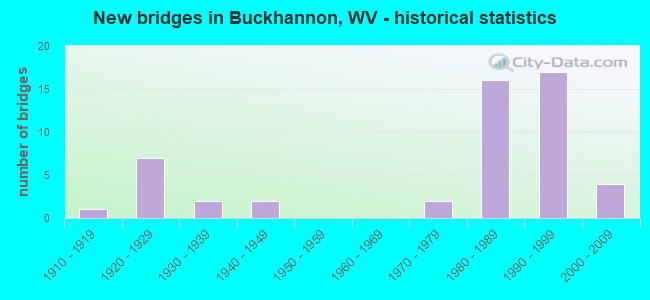
- New bridges - historical statistics
- 11910-1919
- 71920-1929
- 21930-1939
- 21940-1949
- 21970-1979
- 161980-1989
- 171990-1999
- 42000-2009

- Bridge Condition - Deck
- 6.1%Good
- 66.7%Satisfactory
- 27.3%Fair
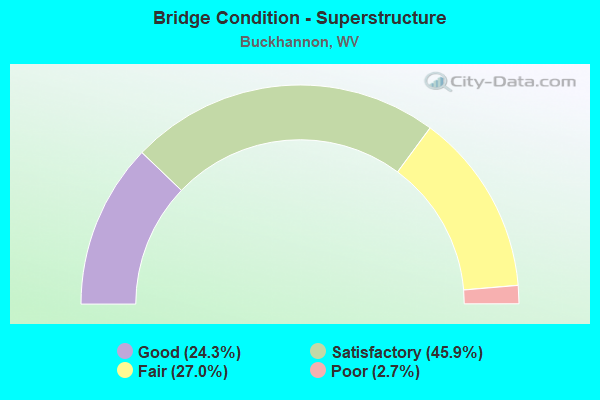
- Bridge Condition - Superstructure
- 24.3%Good
- 45.9%Satisfactory
- 27.0%Fair
- 2.7%Poor
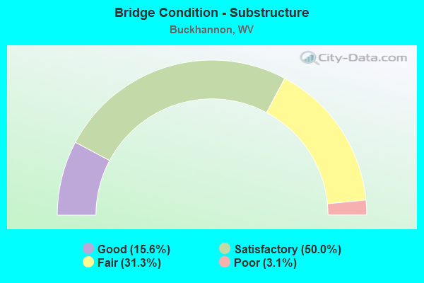
- Bridge Condition - Substructure
- 15.6%Good
- 50.0%Satisfactory
- 31.3%Fair
- 3.1%Poor
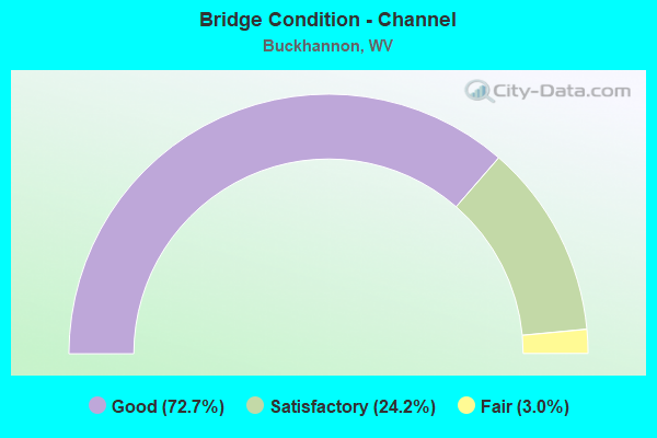
- Bridge Condition - Channel
- 72.7%Good
- 24.2%Satisfactory
- 3.0%Fair
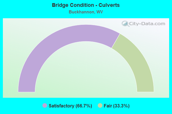
- Bridge Condition - Culverts
- 66.7%Satisfactory
- 33.3%Fair
Find on map >> Show street view
Structure Number: 49A094, Location: 0.05 MI S OF CO RT 13 SLS (Lat: 39.012331, Lng: -80.193311), Route carried "under" structure: County highway 413, Year Built: 1920, Structure Length: 0. m, Average Daily Traffic: 10 (year 2018), Truck Traffic: 8%, Features Intersected: CSX CORP RAILROAD, Facility Carried by Structure: CSX RAILROAD
Minimum Vertical Clearance: 3.28m (10.76ft), Kilometerpoint: 1.481, Lanes under structure: 1, Length of Maximum Span: 5.6m (18.4ft)
Find on map >> Show street view
Structure Number: 49A107, Location: 0.65 MI E OF JCT CO 7 SLS (Lat: 38.996969, Lng: -80.241000), Route carried "under" structure: County highway 1200, Year Built: 1989, Structure Length: 0. m, Average Daily Traffic: 4,300 (year 0009), Truck Traffic: 15%, Features Intersected: Co 12 and CSX Railroad, Facility Carried by Structure: US RT 33 X
Minimum Vertical Clearance: 7.52m (24.67ft), Kilometerpoint: 7.500, Lanes on structure: 2, Lanes under structure: 2, Length of Maximum Span: 50.0m (164.0ft)
Find on map >> Show street view
Structure Number: 49A108, Location: 0.65 MI E OF CO RT 7 SLS (Lat: 38.997039, Lng: -80.241239), Route carried "under" structure: County highway 1200, Year Built: 1989, Structure Length: 0. m, Average Daily Traffic: 4,300 (year 0009), Truck Traffic: 15%, Features Intersected: US RT 33 X, Facility Carried by Structure: US 33 X
Minimum Vertical Clearance: 7.52m (24.67ft), Kilometerpoint: 7.483, Lanes on structure: 2, Lanes under structure: 2, Length of Maximum Span: 34.0m (111.5ft)
Find on map >> Show street view
Structure Number: 49A109, Location: 1.22 MI EAST OF CO RT 7 (Lat: 39.001419, Lng: -80.232450), Route carried "under" structure: US 11900, Year Built: 1989, Structure Length: 0. m, Average Daily Traffic: 5,200 (year 0009), Truck Traffic: 14%, Features Intersected: US 119 and WV 20, Facility Carried by Structure: US ROUTE 33 X
Minimum Vertical Clearance: 5.49m (18.01ft), Kilometerpoint: 8.143, Lanes on structure: 2, Lanes under structure: 5, Length of Maximum Span: 32.6m (107.0ft)
Find on map >> Show street view
Structure Number: 49A11, Location: 1.22 MI EAST OF CO RT 7 (Lat: 39.001631, Lng: -80.232411), Route carried "under" structure: US 11900, Year Built: 1989, Structure Length: 0. m, Average Daily Traffic: 5,200 (year 0009), Truck Traffic: 14%, Features Intersected: US 119 and WV 20, Facility Carried by Structure: US ROUTE 33 X
Minimum Vertical Clearance: 5.89m (19.32ft), Kilometerpoint: 8.143, Lanes on structure: 2, Lanes under structure: 5, Length of Maximum Span: 32.6m (107.0ft)
Find on map >> Show street view
Structure Number: 49A111, Location: 0.40 MI E OF WV 20 (Lat: 39.002589, Lng: -80.225111), Route carried "under" structure: County highway 409, Year Built: 1991, Structure Length: 0. m, Average Daily Traffic: 30 (year 0009), Features Intersected: Co 4/9, Facility Carried by Structure: US 33
Minimum Vertical Clearance: 4.55m (14.93ft), Kilometerpoint: 0.032, Lanes on structure: 5, Lanes under structure: 2, Length of Maximum Span: 10.3m (33.8ft)
Find on map >> Show street view
Structure Number: 49A112, Location: 1.02 MI E OF WV 20 (Lat: 38.999811, Lng: -80.213450), Route carried "under" structure: County highway 1300, Year Built: 1991, Structure Length: 0. m, Average Daily Traffic: 2,100 (year 0009), Truck Traffic: 15%, Features Intersected: CR 13 (SLS) & CSX RR, Facility Carried by Structure: US 33 EBL
Minimum Vertical Clearance: 5.18m (16.99ft), Kilometerpoint: 1.690, Lanes on structure: 2, Lanes under structure: 2, Length of Maximum Span: 25.4m (83.3ft)
Find on map >> Show street view
Structure Number: 49A113, Location: 1.02 MI E. OF WV 20 (Lat: 38.999919, Lng: -80.213339), Route carried "under" structure: County highway 1300, Year Built: 1991, Structure Length: 0. m, Average Daily Traffic: 1,900 (year 0009), Truck Traffic: 15%, Features Intersected: CR 13 (SLS) & CSX RR, Facility Carried by Structure: US 33 WBL
Minimum Vertical Clearance: 6.12m (20.08ft), Kilometerpoint: 1.690, Lanes on structure: 2, Lanes under structure: 2, Length of Maximum Span: 25.2m (82.7ft)
Find on map >> Show street view
Structure Number: 49A12, Location: 0.08 MI EAST OF CO RT 3/6 (Lat: 38.982211, Lng: -80.158511), Route carried "under" structure: County highway 306, Year Built: 1991, Structure Length: 0. m, Average Daily Traffic: 10 (year 0009), Features Intersected: US33, Facility Carried by Structure: US 33 E
Minimum Vertical Clearance: 11.00m (36.09ft), Kilometerpoint: 0.177, Lanes on structure: 2, Lanes under structure: 1, Length of Maximum Span: 38.1m (125.0ft)
Find on map >> Show street view
Structure Number: 49A121, Location: 0.08 MI EAST OF CO RT 3/6 (Lat: 38.982389, Lng: -80.158589), Route carried "under" structure: County highway 306, Year Built: 1991, Structure Length: 0. m, Average Daily Traffic: 10 (year 0009), Features Intersected: US33, Facility Carried by Structure: US 33 W
Minimum Vertical Clearance: 12.57m (41.24ft), Kilometerpoint: 0.193, Lanes on structure: 2, Lanes under structure: 1, Length of Maximum Span: 38.1m (125.0ft)