Bridge Statistics for Buckhannon, West Virginia (WV)
Condition, Traffic, Stress, Structural Evaluation, Project Costs
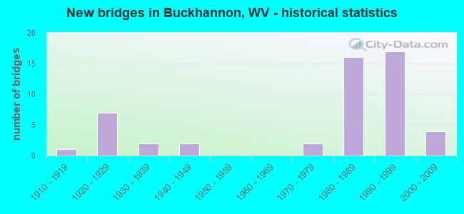
- New bridges - historical statistics
- 11910-1919
- 71920-1929
- 21930-1939
- 21940-1949
- 21970-1979
- 161980-1989
- 171990-1999
- 42000-2009

- Bridge Condition - Deck
- 6.1%Good
- 66.7%Satisfactory
- 27.3%Fair
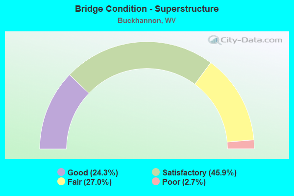
- Bridge Condition - Superstructure
- 24.3%Good
- 45.9%Satisfactory
- 27.0%Fair
- 2.7%Poor
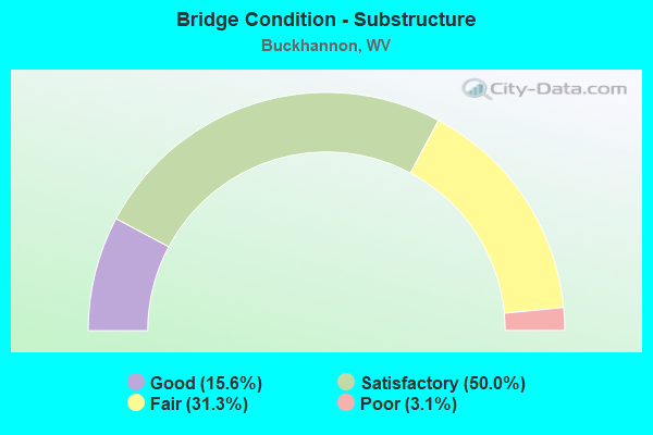
- Bridge Condition - Substructure
- 15.6%Good
- 50.0%Satisfactory
- 31.3%Fair
- 3.1%Poor
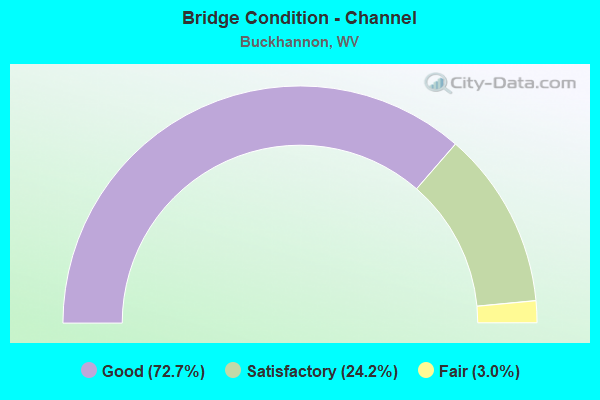
- Bridge Condition - Channel
- 72.7%Good
- 24.2%Satisfactory
- 3.0%Fair
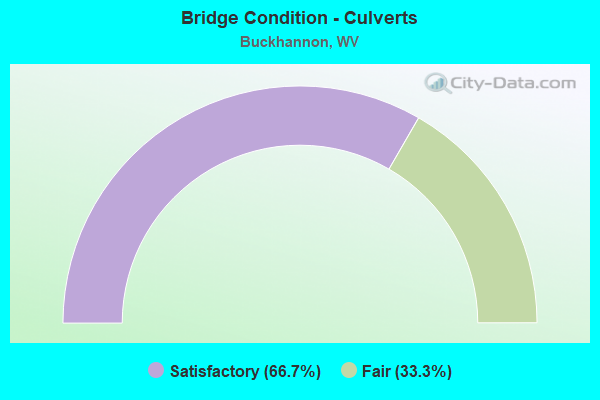
- Bridge Condition - Culverts
- 66.7%Satisfactory
- 33.3%Fair
Find on map >> Show street view
Structure Number: 49A009, Location: 0.01MI W OF CO 3/6 (Lat: 38.998089, Lng: -80.151981), Route carried "on" structure: County highway 300, Year Built: 1970, Status: Open, Structure Length: 1.91m (6.27ft), Average Daily Traffic: 720 (year 2015), Truck Traffic: 15%, Average Future Daily Traffic: 890 (year 2035), Features Intersected: SAND RUN, Facility Carried by Structure: COUNTY ROUTE 3
Minimum Vertical Clearance: 30+ m (98+ ft), Kilometerpoint: 3.959, Lanes on structure: 2, Owner: State Highway Agency, Approaching Roadway Width: 7.3m (24.0ft), Skew: 3 degrees, Material/Design: Steel, Design/Construction: Stringer/Multi-beam, Number Of Spans In Main Unit: 1, Length of Maximum Span: 17.7m (58.1ft), Curb or Sidewalk Widths: Left: 0.2m (0.7ft), Right: 0.2m (0.7ft), Curb-To-Curb Width: 6.7m (22.0ft), Out-to-Out Width: 7.3m (24.0ft)
Condition: Deck: Fair, Superstructure: Fair, Substructure: Fair, Channel: Good, Operating Rating: 51.7 metric tons, Method Used To Determine Operating Rating: Load Factor (LF), Inventory Rating: 30.8 metric tons, Method Used To Determine Inventory Rating: Load Factor (LF), Structural Evaluation: Somewhat better than minimum adequacy, Deck Geometry: Meets minimum limits, Waterway Adequacy: Equal to present desirable criteria, Approach Roadway Alignment: Equal to present desirable criteria, Designated Inspection Frequency: Every 24 months, Inspection Date: March 2020, Deck Structure Type: Closed Grating, Wearing Surface/Protective System: Wearing Surface: Bituminous
Find on map >> Show street view
Structure Number: 49A013, Location: 0.03 MI W OF CO 3 SLS (Lat: 39.005689, Lng: -80.142711), Route carried "on" structure: County highway 304, Year Built: 1915, Status: Open, Structure Length: 1.81m (5.94ft), Average Daily Traffic: 50 (year 2018), Truck Traffic: 8%, Average Future Daily Traffic: 62 (year 2038), Features Intersected: SAND RUN, Facility Carried by Structure: COUNTY ROUTE 3/4
Minimum Vertical Clearance: 30+ m (98+ ft), Kilometerpoint: 3.862, Lanes on structure: 1, Owner: State Highway Agency, Approaching Roadway Width: 4.9m (16.1ft), Material/Design: Concrete, Design/Construction: Arch - Deck, Number Of Spans In Main Unit: 1, Length of Maximum Span: 16.6m (54.5ft), Curb or Sidewalk Widths: Left: 0.3m (1.0ft), Right: 0.3m (1.0ft), Curb-To-Curb Width: 4.1m (13.5ft), Out-to-Out Width: 5.1m (16.7ft)
Condition: Superstructure: Fair, Channel: Good, Operating Rating: 41.7 metric tons, Method Used To Determine Operating Rating: Field evaluation and documented engineering judgment, Inventory Rating: 17.2 metric tons, Method Used To Determine Inventory Rating: Field evaluation and documented engineering judgment, Structural Evaluation: Somewhat better than minimum adequacy, Deck Geometry: Somewhat better than minimum adequacy, Waterway Adequacy: Equal to present desirable criteria, Approach Roadway Alignment: Equal to present minimum criteria, Designated Inspection Frequency: Every 24 months, Inspection Date: December 2020
Find on map >> Show street view
Structure Number: 49A017, Location: 0.01 MI N OF CO RT 22 SLS (Lat: 38.944200, Lng: -80.254911), Route carried "on" structure: State highway 2000, Year Built: 1925, Status: Open, Structure Length: 1.04m (3.41ft), Average Daily Traffic: 6,000 (year 2015), Truck Traffic: 7%, Average Future Daily Traffic: 7,400 (year 2035), Features Intersected: CUTRIGHT RUN, Facility Carried by Structure: WV ROUTE 20 F
Minimum Vertical Clearance: 30+ m (98+ ft), Kilometerpoint: 34.279, Lanes on structure: 2, Owner: State Highway Agency, Approaching Roadway Width: 8.8m (28.9ft), Material/Design: Concrete, Design/Construction: Slab, Number Of Spans In Main Unit: 1, Length of Maximum Span: 7.9m (25.9ft), Curb-To-Curb Width: 9.3m (30.5ft), Out-to-Out Width: 9.7m (31.8ft)
Condition: Deck: Fair, Superstructure: Fair, Substructure: Satisfactory, Channel: Satisfactory, Operating Rating: 39.0 metric tons, Method Used To Determine Operating Rating: Load and Resistance Factor (LRFR), Inventory Rating: 29.0 metric tons, Method Used To Determine Inventory Rating: Load and Resistance Factor (LRFR), Structural Evaluation: Somewhat better than minimum adequacy, Deck Geometry: High priority of corrective action, Waterway Adequacy: Superior to present desirable criteria, Approach Roadway Alignment: Equal to present desirable criteria, Length Of Structure Improvement: 1.77m (5.81ft), Designated Inspection Frequency: Every 24 months, Inspection Date: June 2020, Bridge Improvement Cost: $350,000, Roadway Improvement Cost: $350,000, Total Project Cost: $850,000 ( Estimate for 2020), Deck Structure Type: Concrete Cast-file-Place, Wearing Surface/Protective System: Wearing Surface: Bituminous
Find on map >> Show street view
Structure Number: 49A023, Location: 0.08 MI N OF CO RT 9/25 (Lat: 38.968361, Lng: -80.230100), Route carried "on" structure: County highway 900, Year Built: 1935, Year Reconstructed: 1977, Status: Posted for load, Structure Length: 4.69m (15.39ft), Average Daily Traffic: 4,200 (year 2018), Truck Traffic: 11%, Average Future Daily Traffic: 4,620 (year 2038), Design Load: H 15, Features Intersected: BUCKHANNON RIVER, Facility Carried by Structure: COUNTY ROUTE 9 SLS
Minimum Vertical Clearance: 4.29m (14.07ft), Kilometerpoint: 0.338, Lanes on structure: 2, Owner: State Highway Agency, Approaching Roadway Width: 8.5m (27.9ft), Material/Design: Steel, Design/Construction: Truss - Thru, Number Of Spans In Main Unit: 1, Length of Maximum Span: 45.7m (149.9ft), Curb or Sidewalk Widths: Left: 0.2m (0.7ft), Right: 1.6m (5.2ft), Curb-To-Curb Width: 7.3m (24.0ft), Out-to-Out Width: 7.6m (24.9ft)
Condition: Deck: Fair, Superstructure: Poor, Substructure: Satisfactory, Channel: Satisfactory, Operating Rating: 26.3 metric tons, Method Used To Determine Operating Rating: Load Factor (LF), Inventory Rating: 15.4 metric tons, Method Used To Determine Inventory Rating: Load Factor (LF), Structural Evaluation: Meets minimum limits, Deck Geometry: High priority of replacement, Waterway Adequacy: Superior to present desirable criteria, Approach Roadway Alignment: Equal to present desirable criteria, Bridge Posting: Required (Relationship of Operating Rating to Maximum Legal Load: > 39.9% below), Length Of Structure Improvement: 4.88m (16.01ft), Designated Inspection Frequency: Every 24 months, Critical Feature Inspection Frequency: Every 12 months, Inspection Date: October 2021, Critical Feature Inspection Date: September 2021, Bridge Improvement Cost: $1,800,000, Roadway Improvement Cost: $500,000, Total Project Cost: $2,700,000 ( Estimate for 2021), Deck Structure Type: Closed Grating, Wearing Surface/Protective System: Wearing Surface: Bituminous, Membrane: Built-up
Find on map >> Show street view
Structure Number: 49A029, Location: 0.05 MI S OF CO 16 SLS (Lat: 38.973969, Lng: -80.214839), Route carried "on" structure: County highway 901, Year Built: 1980, Status: Open, Structure Length: 0.82m (2.69ft), Average Daily Traffic: 1,662 (year 2015), Truck Traffic: 15%, Average Future Daily Traffic: 2,054 (year 2035), Design Load: HS 20, Features Intersected: LITTLE SAND RUN, Facility Carried by Structure: COUNTY ROUTE 9/1
Minimum Vertical Clearance: 30+ m (98+ ft), Kilometerpoint: 1.481, Lanes on structure: 2, Owner: State Highway Agency, Approaching Roadway Width: 7.3m (24.0ft), Material/Design: Prestressed concrete, Design/Construction: Slab, Number Of Spans In Main Unit: 1, Length of Maximum Span: 7.8m (25.6ft), Curb or Sidewalk Widths: Left: 0.2m (0.7ft), Right: 0.2m (0.7ft), Curb-To-Curb Width: 8.0m (26.2ft), Out-to-Out Width: 8.5m (27.9ft)
Condition: Deck: Satisfactory, Superstructure: Satisfactory, Substructure: Satisfactory, Channel: Good, Operating Rating: 74.4 metric tons, Method Used To Determine Operating Rating: Load Factor (LF), Inventory Rating: 44.4 metric tons, Method Used To Determine Inventory Rating: Load Factor (LF), Structural Evaluation: Equal to present minimum criteria, Deck Geometry: Meets minimum limits, Waterway Adequacy: Superior to present desirable criteria, Approach Roadway Alignment: Better than present minimum criteria, Length Of Structure Improvement: 0.82m (2.69ft), Designated Inspection Frequency: Every 48 months, Inspection Date: July 2020, Bridge Improvement Cost: $23,000, Roadway Improvement Cost: $10,000, Total Project Cost: $39,000 ( Estimate for 2020), Deck Structure Type: Other, Wearing Surface/Protective System: Wearing Surface: Bituminous
Find on map >> Show street view
Structure Number: 49A039, Location: 0.14 MI N OF CO 16/3 (Lat: 38.940539, Lng: -80.170381), Route carried "on" structure: County highway 1600, Year Built: 1922, Status: Open, Structure Length: 0.71m (2.33ft), Average Daily Traffic: 250 (year 2018), Truck Traffic: 6%, Average Future Daily Traffic: 302 (year 2038), Features Intersected: SAND RUN, Facility Carried by Structure: COUNTY ROUTE 16
Minimum Vertical Clearance: 30+ m (98+ ft), Kilometerpoint: 6.566, Lanes on structure: 1, Owner: State Highway Agency, Approaching Roadway Width: 4.9m (16.1ft), Material/Design: Concrete, Design/Construction: Slab, Number Of Spans In Main Unit: 1, Length of Maximum Span: 6.8m (22.3ft), Curb or Sidewalk Widths: Left: 0.2m (0.7ft), Right: 0.2m (0.7ft), Curb-To-Curb Width: 4.3m (14.1ft), Out-to-Out Width: 5.1m (16.7ft)
Condition: Deck: Fair, Superstructure: Fair, Substructure: Fair, Channel: Good, Operating Rating: 47.2 metric tons, Method Used To Determine Operating Rating: Field evaluation and documented engineering judgment, Inventory Rating: 21.8 metric tons, Method Used To Determine Inventory Rating: Field evaluation and documented engineering judgment, Structural Evaluation: Somewhat better than minimum adequacy, Deck Geometry: High priority of replacement, Waterway Adequacy: Meets minimum limits, Approach Roadway Alignment: Meets minimum limits, Length Of Structure Improvement: 0.91m (2.99ft), Designated Inspection Frequency: Every 24 months, Inspection Date: October 2020, Bridge Improvement Cost: $120,000, Roadway Improvement Cost: $30,000, Total Project Cost: $170,000 ( Estimate for 2021), Deck Structure Type: Concrete Cast-file-Place, Wearing Surface/Protective System: Wearing Surface: Bituminous
Find on map >> Show street view
Structure Number: 49A041, Location: 0.03 MI N OF CO 5/8 (Lat: 38.982189, Lng: -80.216681), Route carried "on" structure: County highway 1600, Year Built: 1988, Status: Open, Structure Length: 4.89m (16.04ft), Average Daily Traffic: 1,700 (year 2015), Truck Traffic: 8%, Average Future Daily Traffic: 2,057 (year 2035), Design Load: HS 20, Features Intersected: BUCKHANNON RIVER, Facility Carried by Structure: COUNTY ROUTE 16
Minimum Vertical Clearance: 30+ m (98+ ft), Kilometerpoint: 14.548, Lanes on structure: 2, Owner: State Highway Agency, Approaching Roadway Width: 7.6m (24.9ft), Material/Design: Steel continuous, Design/Construction: Stringer/Multi-beam, Number Of Spans In Main Unit: 1, Number Of Approach Spans: 2, Length of Maximum Span: 18.0m (59.1ft), Curb or Sidewalk Widths: Left: 1.5m (4.9ft), Right: 0.0m, Curb-To-Curb Width: 7.7m (25.3ft), Out-to-Out Width: 10.1m (33.1ft)
Condition: Deck: Satisfactory, Superstructure: Good, Substructure: Satisfactory, Channel: Good, Operating Rating: 78.9 metric tons, Method Used To Determine Operating Rating: Load Factor (LF), Inventory Rating: 47.2 metric tons, Method Used To Determine Inventory Rating: Load Factor (LF), Structural Evaluation: Equal to present minimum criteria, Deck Geometry: Meets minimum limits, Waterway Adequacy: Superior to present desirable criteria, Approach Roadway Alignment: Better than present minimum criteria, Designated Inspection Frequency: Every 24 months, Underwater Inspection Frequency: Every 60 months, Inspection Date: May 2020, Underwater Inspection Date: July 2017, Deck Structure Type: Concrete Cast-file-Place, Wearing Surface/Protective System: Wearing Surface: Monolithic Concrete, Deck Protection: Epoxy Coated Reinforcing
Find on map >> Show street view
Structure Number: 49A045, Location: 0.15 MI W CO 4/8 (Lat: 39.023061, Lng: -80.205631), Route carried "on" structure: County highway 2006, Year Built: 1920, Status: Posted for load, Structure Length: 0.74m (2.43ft), Average Daily Traffic: 100 (year 2015), Average Future Daily Traffic: 121 (year 2035), Features Intersected: TURKEY RUN, Facility Carried by Structure: COUNTY ROUTE 20/6
Minimum Vertical Clearance: 30+ m (98+ ft), Kilometerpoint: 2.430, Lanes on structure: 1, Owner: State Highway Agency, Approaching Roadway Width: 4.9m (16.1ft), Material/Design: Concrete, Design/Construction: Slab, Number Of Spans In Main Unit: 1, Length of Maximum Span: 6.9m (22.6ft), Curb-To-Curb Width: 4.5m (14.8ft), Out-to-Out Width: 5.0m (16.4ft)
Condition: Deck: Fair, Superstructure: Fair, Substructure: Poor, Channel: Good, Operating Rating: 31.7 metric tons, Method Used To Determine Operating Rating: Field evaluation and documented engineering judgment, Inventory Rating: 14.5 metric tons, Method Used To Determine Inventory Rating: Field evaluation and documented engineering judgment, Structural Evaluation: Meets minimum limits, Deck Geometry: Equal to present minimum criteria, Waterway Adequacy: Equal to present minimum criteria, Approach Roadway Alignment: Equal to present desirable criteria, Bridge Posting: Required (Relationship of Operating Rating to Maximum Legal Load: 20.0 - 29.9% below), Length Of Structure Improvement: 1.07m (3.51ft), Designated Inspection Frequency: Every 24 months, Inspection Date: July 2020, Bridge Improvement Cost: $170,000, Roadway Improvement Cost: $20,000, Total Project Cost: $210,000 ( Estimate for 2020), Deck Structure Type: Concrete Cast-file-Place, Wearing Surface/Protective System: Wearing Surface: Bituminous
Find on map >> Show street view
Structure Number: 49A052, Location: 0.03 MI E OF CO 30/7 (Lat: 38.914869, Lng: -80.229500), Route carried "on" structure: County highway 2200, Year Built: 1990, Status: Open, Structure Length: 5.40m (17.72ft), Average Daily Traffic: 200 (year 2015), Truck Traffic: 15%, Average Future Daily Traffic: 242 (year 2035), Design Load: HS 25 or greater, Features Intersected: BUCKHANNON RIVER, Facility Carried by Structure: COUNTY ROUTE 22
Minimum Vertical Clearance: 30+ m (98+ ft), Kilometerpoint: 9.656, Lanes on structure: 1, Owner: State Highway Agency, Approaching Roadway Width: 7.0m (23.0ft), Material/Design: Steel continuous, Design/Construction: Stringer/Multi-beam, Number Of Spans In Main Unit: 2, Number Of Approach Spans: 2, Length of Maximum Span: 13.2m (43.3ft), Curb or Sidewalk Widths: Left: 0.2m (0.7ft), Right: 0.2m (0.7ft), Curb-To-Curb Width: 4.6m (15.1ft), Out-to-Out Width: 5.6m (18.4ft)
Condition: Deck: Satisfactory, Superstructure: Good, Substructure: Fair, Channel: Satisfactory, Operating Rating: 80.7 metric tons, Method Used To Determine Operating Rating: Load Factor (LF), Inventory Rating: 48.1 metric tons, Method Used To Determine Inventory Rating: Load Factor (LF), Structural Evaluation: Somewhat better than minimum adequacy, Deck Geometry: High priority of replacement, Waterway Adequacy: Equal to present desirable criteria, Approach Roadway Alignment: Equal to present minimum criteria, Designated Inspection Frequency: Every 24 months, Underwater Inspection Frequency: Every 12 months, Inspection Date: May 2020, Underwater Inspection Date: July 2021, Deck Structure Type: Concrete Cast-file-Place, Wearing Surface/Protective System: Deck Protection: Epoxy Coated Reinforcing
Find on map >> Show street view
Structure Number: 49A067, Location: 0.22 MI E OF CO 33/1 SLS (Lat: 38.996231, Lng: -80.238969), Route carried "on" structure: County highway 1200, Year Built: 1945, Status: Open, Structure Length: 0.87m (2.85ft), Average Daily Traffic: 6,800 (year 2018), Truck Traffic: 8%, Average Future Daily Traffic: 8,400 (year 2038), Features Intersected: BRUSHY FORK, Facility Carried by Structure: CO 12 (SLS)
Minimum Vertical Clearance: 30+ m (98+ ft), Kilometerpoint: 7.773, Lanes on structure: 2, Owner: State Highway Agency, Approaching Roadway Width: 14.6m (47.9ft), Material/Design: Concrete, Design/Construction: Arch - Deck, Number Of Spans In Main Unit: 1, Length of Maximum Span: 7.2m (23.6ft), Curb or Sidewalk Widths: Left: 2.9m (9.5ft), Right: 0.0m, Curb-To-Curb Width: 9.8m (32.2ft), Out-to-Out Width: 15.4m (50.5ft)
Condition: Superstructure: Fair, Substructure: Satisfactory, Channel: Satisfactory, Operating Rating: 53.5 metric tons, Method Used To Determine Operating Rating: Field evaluation and documented engineering judgment, Inventory Rating: 24.5 metric tons, Method Used To Determine Inventory Rating: Field evaluation and documented engineering judgment, Structural Evaluation: Somewhat better than minimum adequacy, Deck Geometry: Meets minimum limits, Waterway Adequacy: Superior to present desirable criteria, Approach Roadway Alignment: Equal to present desirable criteria, Length Of Structure Improvement: 1.52m (4.99ft), Designated Inspection Frequency: Every 24 months, Underwater Inspection Frequency: Every 60 months, Inspection Date: March 2021, Underwater Inspection Date: July 2019, Bridge Improvement Cost: $350,000, Roadway Improvement Cost: $150,000, Total Project Cost: $750,000 ( Estimate for 2021), Deck Structure Type: Concrete Cast-file-Place, Wearing Surface/Protective System: Wearing Surface: Bituminous
Find on map >> Show street view
Structure Number: 49A068, Location: 0.28 MI E OF WV 20 (Lat: 38.995119, Lng: -80.227639), Route carried "on" structure: County highway 15100, Year Built: 1993, Status: Open, Structure Length: 4.61m (15.12ft), Average Daily Traffic: 2,891 (year 2015), Truck Traffic: 12%, Average Future Daily Traffic: 3,572 (year 2035), Design Load: HS 25 or greater, Features Intersected: BUCKHANNON RIVER, Facility Carried by Structure: CO 151
Minimum Vertical Clearance: 30+ m (98+ ft), Kilometerpoint: 0.451, Lanes on structure: 2, Owner: State Highway Agency, Approaching Roadway Width: 9.1m (29.9ft), Skew: 1 degrees, Material/Design: Steel continuous, Design/Construction: Stringer/Multi-beam, Number Of Spans In Main Unit: 2, Length of Maximum Span: 22.4m (73.5ft), Curb or Sidewalk Widths: Left: 1.5m (4.9ft), Right: 1.5m (4.9ft), Curb-To-Curb Width: 10.3m (33.8ft), Out-to-Out Width: 11.9m (39.0ft)
Condition: Deck: Satisfactory, Superstructure: Good, Substructure: Satisfactory, Channel: Good, Operating Rating: 88.9 metric tons, Method Used To Determine Operating Rating: Load Factor (LF), Inventory Rating: 53.5 metric tons, Method Used To Determine Inventory Rating: Load Factor (LF), Structural Evaluation: Equal to present minimum criteria, Deck Geometry: Meets minimum limits, Waterway Adequacy: Superior to present desirable criteria, Approach Roadway Alignment: Equal to present desirable criteria, Designated Inspection Frequency: Every 48 months, Inspection Date: August 2019, Deck Structure Type: Concrete Cast-file-Place, Wearing Surface/Protective System: Wearing Surface: Monolithic Concrete, Deck Protection: Epoxy Coated Reinforcing
Find on map >> Show street view
Structure Number: 49A069, Location: 0.68 MI E OF WV 20 F (Lat: 38.995589, Lng: -80.220519), Route carried "on" structure: County highway 15100, Year Built: 1922, Status: Open, Structure Length: 1.69m (5.54ft), Average Daily Traffic: 2,700 (year 2018), Truck Traffic: 8%, Average Future Daily Traffic: 3,267 (year 2038), Features Intersected: MILL RACE, Facility Carried by Structure: CO 151 SLS
Minimum Vertical Clearance: 30+ m (98+ ft), Kilometerpoint: 1.094, Lanes on structure: 2, Owner: State Highway Agency, Approaching Roadway Width: 9.1m (29.9ft), Material/Design: Concrete, Design/Construction: Arch - Deck, Number Of Spans In Main Unit: 1, Length of Maximum Span: 15.2m (49.9ft), Curb or Sidewalk Widths: Left: 1.5m (4.9ft), Right: 0.0m, Curb-To-Curb Width: 9.1m (29.9ft), Out-to-Out Width: 11.6m (38.1ft)
Condition: Superstructure: Fair, Substructure: Fair, Channel: Good, Operating Rating: 55.3 metric tons, Method Used To Determine Operating Rating: Field evaluation and documented engineering judgment, Inventory Rating: 23.6 metric tons, Method Used To Determine Inventory Rating: Field evaluation and documented engineering judgment, Structural Evaluation: Somewhat better than minimum adequacy, Deck Geometry: Meets minimum limits, Waterway Adequacy: Superior to present desirable criteria, Approach Roadway Alignment: Better than present minimum criteria, Length Of Structure Improvement: 3.05m (10.01ft), Designated Inspection Frequency: Every 24 months, Inspection Date: March 2021, Bridge Improvement Cost: $600,000, Roadway Improvement Cost: $250,000, Total Project Cost: $1,000,000 ( Estimate for 2021)
Find on map >> Show street view
Structure Number: 49A07, Location: 0.05 MI W OF CO 33/3 SLS (Lat: 38.963289, Lng: -80.153731), Route carried "on" structure: County highway 15100, Year Built: 1922, Status: Open, Structure Length: 0.72m (2.36ft), Average Daily Traffic: 1,400 (year 2018), Truck Traffic: 8%, Average Future Daily Traffic: 1,700 (year 2038), Features Intersected: SAND RUN, Facility Carried by Structure: CO 151
Minimum Vertical Clearance: 30+ m (98+ ft), Kilometerpoint: 8.755, Lanes on structure: 2, Owner: State Highway Agency, Approaching Roadway Width: 9.1m (29.9ft), Material/Design: Concrete, Design/Construction: Culvert, Number Of Spans In Main Unit: 1, Length of Maximum Span: 6.4m (21.0ft)
Condition: Channel: Good, Culverts: Fair, Operating Rating: 63.5 metric tons, Method Used To Determine Operating Rating: Field evaluation and documented engineering judgment, Inventory Rating: 29.0 metric tons, Method Used To Determine Inventory Rating: Field evaluation and documented engineering judgment, Structural Evaluation: Somewhat better than minimum adequacy, Waterway Adequacy: Superior to present desirable criteria, Approach Roadway Alignment: Equal to present desirable criteria, Length Of Structure Improvement: 0.91m (2.99ft), Designated Inspection Frequency: Every 24 months, Inspection Date: March 2021, Bridge Improvement Cost: $150,000, Roadway Improvement Cost: $50,000, Total Project Cost: $250,000 ( Estimate for 2021)
Find on map >> Show street view
Structure Number: 49A084, Location: 0.16 MI S CO 13 (Lat: 38.998250, Lng: -80.232361), Route carried "on" structure: State highway 2000, Year Built: 1927, Status: Open, Structure Length: 0.87m (2.85ft), Average Daily Traffic: 16,800 (year 2018), Truck Traffic: 8%, Average Future Daily Traffic: 20,328 (year 2038), Features Intersected: BRUSHY FORK, Facility Carried by Structure: WV 20
Minimum Vertical Clearance: 30+ m (98+ ft), Kilometerpoint: 41.634, Lanes on structure: 3, Owner: State Highway Agency, Approaching Roadway Width: 17.7m (58.1ft), Material/Design: Concrete, Design/Construction: Arch - Deck, Number Of Spans In Main Unit: 1, Length of Maximum Span: 7.7m (25.3ft), Curb or Sidewalk Widths: Left: 1.5m (4.9ft), Right: 1.5m (4.9ft), Curb-To-Curb Width: 12.2m (40.0ft), Out-to-Out Width: 16.9m (55.4ft)
Condition: Superstructure: Fair, Channel: Good, Operating Rating: 63.5 metric tons, Method Used To Determine Operating Rating: Field evaluation and documented engineering judgment, Inventory Rating: 29.0 metric tons, Method Used To Determine Inventory Rating: Field evaluation and documented engineering judgment, Structural Evaluation: Somewhat better than minimum adequacy, Deck Geometry: Meets minimum limits, Waterway Adequacy: Superior to present desirable criteria, Approach Roadway Alignment: Equal to present desirable criteria, Designated Inspection Frequency: Every 24 months, Inspection Date: May 2021
Find on map >> Show street view
Structure Number: 49A085, Location: 0.14 MI N CO 20/5 (Lat: 39.029211, Lng: -80.220311), Route carried "on" structure: US 11900, Year Built: 1935, Status: Open, Structure Length: 0.95m (3.12ft), Average Daily Traffic: 4,100 (year 2018), Truck Traffic: 16%, Average Future Daily Traffic: 5,070 (year 2038), Features Intersected: TURKEY RUN, Facility Carried by Structure: US 119
Minimum Vertical Clearance: 30+ m (98+ ft), Kilometerpoint: 11.716, Lanes on structure: 2, Base Highway Network: Yes, Owner: State Highway Agency, Approaching Roadway Width: 10.4m (34.1ft), Material/Design: Concrete, Design/Construction: Slab, Number Of Spans In Main Unit: 1, Length of Maximum Span: 7.9m (25.9ft), Curb-To-Curb Width: 9.5m (31.2ft), Out-to-Out Width: 10.0m (32.8ft)
Condition: Deck: Fair, Superstructure: Fair, Substructure: Satisfactory, Channel: Good, Operating Rating: 63.5 metric tons, Method Used To Determine Operating Rating: Field evaluation and documented engineering judgment, Inventory Rating: 29.0 metric tons, Method Used To Determine Inventory Rating: Field evaluation and documented engineering judgment, Structural Evaluation: Somewhat better than minimum adequacy, Deck Geometry: Meets minimum limits, Waterway Adequacy: Equal to present desirable criteria, Approach Roadway Alignment: Equal to present desirable criteria, Length Of Structure Improvement: 1.59m (5.22ft), Designated Inspection Frequency: Every 24 months, Inspection Date: Febuary 2021, Bridge Improvement Cost: $235,000, Roadway Improvement Cost: $233,000, Total Project Cost: $578,000 ( Estimate for 2019), Deck Structure Type: Concrete Cast-file-Place, Wearing Surface/Protective System: Wearing Surface: Bituminous
Find on map >> Show street view
Structure Number: 49A095, Location: 0.04 MI S OF US 33 (Lat: 38.999211, Lng: -80.252539), Route carried "on" structure: County highway 700, Year Built: 1980, Status: Open, Structure Length: 1.33m (4.36ft), Average Daily Traffic: 4,212 (year 2015), Truck Traffic: 15%, Average Future Daily Traffic: 5,205 (year 2035), Design Load: HS 20, Features Intersected: FINK RUN, Facility Carried by Structure: COUNTY ROUTE 7
Minimum Vertical Clearance: 30+ m (98+ ft), Kilometerpoint: 0.274, Lanes on structure: 2, Owner: State Highway Agency, Approaching Roadway Width: 7.3m (24.0ft), Skew: 3 degrees, Material/Design: Concrete, Design/Construction: Frame, Number Of Spans In Main Unit: 1, Length of Maximum Span: 11.0m (36.1ft), Curb-To-Curb Width: 12.3m (40.4ft), Out-to-Out Width: 13.4m (44.0ft)
Condition: Deck: Satisfactory, Superstructure: Satisfactory, Channel: Satisfactory, Operating Rating: 88.9 metric tons, Method Used To Determine Operating Rating: Load Factor (LF), Inventory Rating: 54.4 metric tons, Method Used To Determine Inventory Rating: Load Factor (LF), Structural Evaluation: Equal to present minimum criteria, Deck Geometry: Equal to present minimum criteria, Waterway Adequacy: Better than present minimum criteria, Approach Roadway Alignment: Equal to present desirable criteria, Length Of Structure Improvement: 1.34m (4.40ft), Designated Inspection Frequency: Every 48 months, Inspection Date: October 2019, Bridge Improvement Cost: $58,000, Roadway Improvement Cost: $10,000, Total Project Cost: $83,000 ( Estimate for 2020), Deck Structure Type: Concrete Cast-file-Place, Wearing Surface/Protective System: Deck Protection: Epoxy Coated Reinforcing
Find on map >> Show street view
Structure Number: 49A096, Location: 0.02 MI S OF US 33 (Lat: 39.003050, Lng: -80.263400), Route carried "on" structure: County highway 3302, Year Built: 1980, Status: Open, Structure Length: 1.05m (3.44ft), Average Daily Traffic: 22 (year 2015), Truck Traffic: 8%, Average Future Daily Traffic: 27 (year 2035), Design Load: HS 20, Features Intersected: FINK RUN, Facility Carried by Structure: COUNTY ROUTE 33/2
Minimum Vertical Clearance: 30+ m (98+ ft), Kilometerpoint: 0.113, Lanes on structure: 2, Owner: State Highway Agency, Approaching Roadway Width: 11.0m (36.1ft), Skew: 1 degrees, Material/Design: Concrete, Design/Construction: Frame, Number Of Spans In Main Unit: 1, Length of Maximum Span: 9.3m (30.5ft), Curb or Sidewalk Widths: Left: 0.2m (0.7ft), Right: 0.2m (0.7ft), Curb-To-Curb Width: 12.0m (39.4ft), Out-to-Out Width: 13.1m (43.0ft)
Condition: Deck: Satisfactory, Superstructure: Satisfactory, Channel: Good, Operating Rating: 88.9 metric tons, Method Used To Determine Operating Rating: Load Factor (LF), Inventory Rating: 54.4 metric tons, Method Used To Determine Inventory Rating: Load Factor (LF), Structural Evaluation: Equal to present minimum criteria, Deck Geometry: Superior to present desirable criteria, Waterway Adequacy: Equal to present minimum criteria, Approach Roadway Alignment: Equal to present desirable criteria, Designated Inspection Frequency: Every 48 months, Inspection Date: November 2019, Deck Structure Type: Concrete Cast-file-Place, Wearing Surface/Protective System: Deck Protection: Epoxy Coated Reinforcing
Find on map >> Show street view
Structure Number: 49A097, Location: 0.03 MI S OF US 33 (Lat: 39.004719, Lng: -80.274719), Route carried "on" structure: County highway 1203, Year Built: 1980, Status: Open, Structure Length: 1.07m (3.51ft), Average Daily Traffic: 11 (year 2015), Average Future Daily Traffic: 14 (year 2035), Design Load: HS 20, Features Intersected: FINK RUN, Facility Carried by Structure: COUNTY ROUTE 12/3
Minimum Vertical Clearance: 30+ m (98+ ft), Kilometerpoint: 0.225, Lanes on structure: 2, Owner: State Highway Agency, Approaching Roadway Width: 11.0m (36.1ft), Material/Design: Concrete, Design/Construction: Frame, Number Of Spans In Main Unit: 1, Length of Maximum Span: 9.1m (29.9ft), Curb-To-Curb Width: 11.9m (39.0ft), Out-to-Out Width: 13.0m (42.7ft)
Condition: Deck: Satisfactory, Superstructure: Satisfactory, Channel: Fair, Operating Rating: 87.1 metric tons, Method Used To Determine Operating Rating: Load Factor (LF), Inventory Rating: 52.6 metric tons, Method Used To Determine Inventory Rating: Load Factor (LF), Structural Evaluation: Equal to present minimum criteria, Deck Geometry: Superior to present desirable criteria, Waterway Adequacy: Equal to present desirable criteria, Approach Roadway Alignment: Equal to present desirable criteria, Designated Inspection Frequency: Every 48 months, Inspection Date: October 2019, Deck Structure Type: Concrete Cast-file-Place
Find on map >> Show street view
Structure Number: 49A098, Location: 0.02 MI S OF US 33 X (Lat: 39.007789, Lng: -80.285750), Route carried "on" structure: County highway 505, Year Built: 1980, Status: Open, Structure Length: 0.66m (2.17ft), Average Daily Traffic: 55 (year 2015), Average Future Daily Traffic: 68 (year 2035), Design Load: HS 20, Features Intersected: FINK RUN, Facility Carried by Structure: COUNTY ROUTE 5/5
Minimum Vertical Clearance: 30+ m (98+ ft), Kilometerpoint: 0.129, Lanes on structure: 2, Owner: State Highway Agency, Approaching Roadway Width: 11.0m (36.1ft), Skew: 2 degrees, Material/Design: Concrete, Design/Construction: Culvert, Number Of Spans In Main Unit: 1, Length of Maximum Span: 6.6m (21.7ft)
Condition: Channel: Satisfactory, Culverts: Satisfactory, Operating Rating: 71.7 metric tons, Method Used To Determine Operating Rating: Field evaluation and documented engineering judgment, Inventory Rating: 32.7 metric tons, Method Used To Determine Inventory Rating: Field evaluation and documented engineering judgment, Structural Evaluation: Equal to present minimum criteria, Waterway Adequacy: Superior to present desirable criteria, Approach Roadway Alignment: Equal to present desirable criteria, Designated Inspection Frequency: Every 48 months, Inspection Date: October 2019
Find on map >> Show street view
Structure Number: 49A099, Location: 0.06 MI S OF US 33 X (Lat: 39.010350, Lng: -80.302539), Route carried "on" structure: County highway 501, Year Built: 1977, Status: Open, Structure Length: 1.15m (3.77ft), Average Daily Traffic: 100 (year 2015), Average Future Daily Traffic: 125 (year 2035), Design Load: HS 20, Features Intersected: FINK RUN, Facility Carried by Structure: COUNTY RT 5/1 SLS
Minimum Vertical Clearance: 30+ m (98+ ft), Kilometerpoint: 3.766, Lanes on structure: 2, Owner: State Highway Agency, Approaching Roadway Width: 7.9m (25.9ft), Material/Design: Steel, Design/Construction: Culvert, Number Of Spans In Main Unit: 2, Length of Maximum Span: 5.0m (16.4ft)
Condition: Channel: Satisfactory, Culverts: Satisfactory, Operating Rating: 53.5 metric tons, Method Used To Determine Operating Rating: Field evaluation and documented engineering judgment, Inventory Rating: 24.5 metric tons, Method Used To Determine Inventory Rating: Field evaluation and documented engineering judgment, Structural Evaluation: Equal to present minimum criteria, Waterway Adequacy: Equal to present desirable criteria, Approach Roadway Alignment: Equal to present minimum criteria, Length Of Structure Improvement: 1.01m (3.31ft), Designated Inspection Frequency: Every 48 months, Inspection Date: November 2019, Bridge Improvement Cost: $20,000, Roadway Improvement Cost: $5,000, Total Project Cost: $30,000 ( Estimate for 2020)
Find on map >> Show street view
Structure Number: 49A102, Location: 1.08 MI W OF CO 4/13 SLS (Lat: 39.005669, Lng: -80.209681), Route carried "on" structure: County highway 1300, Year Built: 1984, Status: Open, Structure Length: 6.75m (22.15ft), Average Daily Traffic: 1,300 (year 2018), Truck Traffic: 8%, Average Future Daily Traffic: 1,573 (year 2038), Design Load: HS 20+Mod, Features Intersected: BUCKHANNON RIVER, Facility Carried by Structure: COUNTY ROUTE 13
Minimum Vertical Clearance: 30+ m (98+ ft), Kilometerpoint: 2.527, Lanes on structure: 2, Owner: State Highway Agency, Approaching Roadway Width: 7.9m (25.9ft), Material/Design: Steel continuous, Design/Construction: Stringer/Multi-beam, Number Of Spans In Main Unit: 2, Length of Maximum Span: 32.9m (107.9ft), Curb-To-Curb Width: 9.4m (30.8ft), Out-to-Out Width: 10.5m (34.4ft)
Condition: Deck: Satisfactory, Superstructure: Good, Substructure: Satisfactory, Channel: Good, Operating Rating: 69.8 metric tons, Method Used To Determine Operating Rating: Load Factor (LF), Inventory Rating: 41.7 metric tons, Method Used To Determine Inventory Rating: Load Factor (LF), Structural Evaluation: Equal to present minimum criteria, Deck Geometry: Somewhat better than minimum adequacy, Waterway Adequacy: Superior to present desirable criteria, Approach Roadway Alignment: Equal to present desirable criteria, Designated Inspection Frequency: Every 24 months, Underwater Inspection Frequency: Every 60 months, Inspection Date: October 2020, Underwater Inspection Date: August 2018, Deck Structure Type: Concrete Cast-file-Place, Wearing Surface/Protective System: Deck Protection: Epoxy Coated Reinforcing
Find on map >> Show street view
Structure Number: 49A103, Location: 0.02 MI. E. CO. 4/13 (Lat: 39.012769, Lng: -80.192900), Route carried "on" structure: County highway 1300, Year Built: 1983, Status: Open, Structure Length: 7.03m (23.06ft), Average Daily Traffic: 900 (year 2018), Truck Traffic: 8%, Average Future Daily Traffic: 1,110 (year 2038), Design Load: HS 20, Features Intersected: BUCKHANNON RIVER, Facility Carried by Structure: COUNTY ROUTE 13
Minimum Vertical Clearance: 30+ m (98+ ft), Kilometerpoint: 4.297, Lanes on structure: 2, Owner: State Highway Agency, Approaching Roadway Width: 7.3m (24.0ft), Skew: 1 degrees, Material/Design: Steel continuous, Design/Construction: Stringer/Multi-beam, Number Of Spans In Main Unit: 2, Length of Maximum Span: 34.3m (112.5ft), Curb-To-Curb Width: 9.4m (30.8ft), Out-to-Out Width: 10.5m (34.4ft)
Condition: Deck: Satisfactory, Superstructure: Good, Substructure: Satisfactory, Channel: Satisfactory, Operating Rating: 69.8 metric tons, Method Used To Determine Operating Rating: Load Factor (LF), Inventory Rating: 41.7 metric tons, Method Used To Determine Inventory Rating: Load Factor (LF), Structural Evaluation: Equal to present minimum criteria, Deck Geometry: Equal to present minimum criteria, Waterway Adequacy: Superior to present desirable criteria, Approach Roadway Alignment: Equal to present desirable criteria, Designated Inspection Frequency: Every 24 months, Underwater Inspection Frequency: Every 60 months, Inspection Date: November 2020, Underwater Inspection Date: September 2019, Deck Structure Type: Concrete Cast-file-Place, Wearing Surface/Protective System: Wearing Surface: Monolithic Concrete, Deck Protection: Epoxy Coated Reinforcing
Find on map >> Show street view
Structure Number: 49A107, Location: 0.65 MI E OF JCT CO 7 SLS (Lat: 38.996969, Lng: -80.241000), Route carried "on" structure: US 3300, Year Built: 1989, Status: Open, Structure Length: 9.78m (32.09ft), Average Daily Traffic: 8,100 (year 2018), Truck Traffic: 14%, Average Future Daily Traffic: 8,505 (year 2038), Design Load: HS 20+Mod, Features Intersected: Co 12 and CSX Railroad, Facility Carried by Structure: US RT 33 X
Minimum Vertical Clearance: 30+ m (98+ ft), Kilometerpoint: 7.210, Lanes on structure: 2, Lanes under structure: 2, Base Highway Network: Yes, Owner: State Highway Agency, Approaching Roadway Width: 11.6m (38.1ft), Skew: 4 degrees, Material/Design: Steel, Design/Construction: Stringer/Multi-beam, Number Of Spans In Main Unit: 1, Number Of Approach Spans: 2, Length of Maximum Span: 50.0m (164.0ft), Curb-To-Curb Width: 12.4m (40.7ft), Out-to-Out Width: 13.5m (44.3ft)
Condition: Deck: Satisfactory, Superstructure: Satisfactory, Substructure: Fair, Operating Rating: 88.9 metric tons, Method Used To Determine Operating Rating: Load Factor (LF), Inventory Rating: 71.7 metric tons, Method Used To Determine Inventory Rating: Load Factor (LF), Structural Evaluation: Somewhat better than minimum adequacy, Deck Geometry: Better than present minimum criteria, Underclear: Better than present minimum criteria, Approach Roadway Alignment: Equal to present desirable criteria, Designated Inspection Frequency: Every 24 months, Inspection Date: October 2021, Deck Structure Type: Concrete Cast-file-Place, Wearing Surface/Protective System: Wearing Surface: Monolithic Concrete, Deck Protection: Epoxy Coated Reinforcing
Find on map >> Show street view
Structure Number: 49A108, Location: 0.65 MI E OF CO RT 7 SLS (Lat: 38.997039, Lng: -80.241239), Route carried "on" structure: US 3300, Year Built: 1989, Status: Open, Structure Length: 8.81m (28.90ft), Average Daily Traffic: 8,100 (year 2018), Truck Traffic: 14%, Average Future Daily Traffic: 8,505 (year 2038), Design Load: HS 20+Mod, Features Intersected: US RT 33 X, Facility Carried by Structure: US 33 X
Minimum Vertical Clearance: 30+ m (98+ ft), Kilometerpoint: 7.210, Lanes on structure: 2, Lanes under structure: 2, Base Highway Network: Yes, Owner: State Highway Agency, Approaching Roadway Width: 11.6m (38.1ft), Skew: 4 degrees, Material/Design: Steel continuous, Design/Construction: Stringer/Multi-beam, Number Of Spans In Main Unit: 1, Number Of Approach Spans: 2, Length of Maximum Span: 34.0m (111.5ft), Curb-To-Curb Width: 12.4m (40.7ft), Out-to-Out Width: 13.5m (44.3ft)
Condition: Deck: Satisfactory, Superstructure: Satisfactory, Substructure: Fair, Operating Rating: 65.3 metric tons, Method Used To Determine Operating Rating: Load Factor (LF), Inventory Rating: 39.0 metric tons, Method Used To Determine Inventory Rating: Load Factor (LF), Structural Evaluation: Somewhat better than minimum adequacy, Deck Geometry: Better than present minimum criteria, Underclear: Better than present minimum criteria, Approach Roadway Alignment: Equal to present desirable criteria, Designated Inspection Frequency: Every 24 months, Inspection Date: October 2021, Deck Structure Type: Concrete Cast-file-Place, Wearing Surface/Protective System: Deck Protection: Epoxy Coated Reinforcing
Find on map >> Show street view
Structure Number: 49A109, Location: 1.22 MI EAST OF CO RT 7 (Lat: 39.001419, Lng: -80.232450), Route carried "on" structure: US 3300, Year Built: 1989, Status: Open, Structure Length: 5.46m (17.91ft), Average Daily Traffic: 6,750 (year 2018), Truck Traffic: 14%, Average Future Daily Traffic: 7,088 (year 2038), Design Load: HS 20+Mod, Features Intersected: US 119 and WV 20, Facility Carried by Structure: US ROUTE 33 X
Minimum Vertical Clearance: 30+ m (98+ ft), Kilometerpoint: 8.127, Lanes on structure: 2, Lanes under structure: 5, Base Highway Network: Yes, Owner: State Highway Agency, Approaching Roadway Width: 11.6m (38.1ft), Skew: 1 degrees, Material/Design: Steel, Design/Construction: Stringer/Multi-beam, Number Of Spans In Main Unit: 1, Number Of Approach Spans: 2, Length of Maximum Span: 32.6m (107.0ft), Curb-To-Curb Width: 12.4m (40.7ft), Out-to-Out Width: 13.5m (44.3ft)
Condition: Deck: Satisfactory, Superstructure: Satisfactory, Substructure: Fair, Operating Rating: 68.9 metric tons, Method Used To Determine Operating Rating: Load Factor (LF), Inventory Rating: 40.8 metric tons, Method Used To Determine Inventory Rating: Load Factor (LF), Structural Evaluation: Somewhat better than minimum adequacy, Deck Geometry: Better than present minimum criteria, Underclear: Equal to present minimum criteria, Approach Roadway Alignment: Equal to present desirable criteria, Designated Inspection Frequency: Every 24 months, Inspection Date: October 2021, Deck Structure Type: Concrete Cast-file-Place, Wearing Surface/Protective System: Deck Protection: Epoxy Coated Reinforcing
Find on map >> Show street view
Structure Number: 49A11, Location: 1.22 MI EAST OF CO RT 7 (Lat: 39.001631, Lng: -80.232411), Route carried "on" structure: US 3300, Year Built: 1989, Status: Open, Structure Length: 5.46m (17.91ft), Average Daily Traffic: 6,750 (year 2018), Truck Traffic: 14%, Average Future Daily Traffic: 7,088 (year 2038), Design Load: HS 20, Features Intersected: US 119 and WV 20, Facility Carried by Structure: US ROUTE 33 X
Minimum Vertical Clearance: 30+ m (98+ ft), Kilometerpoint: 8.127, Lanes on structure: 2, Lanes under structure: 5, Base Highway Network: Yes, Owner: State Highway Agency, Approaching Roadway Width: 11.6m (38.1ft), Skew: 1 degrees, Material/Design: Steel, Design/Construction: Stringer/Multi-beam, Number Of Spans In Main Unit: 1, Number Of Approach Spans: 2, Length of Maximum Span: 32.6m (107.0ft), Curb-To-Curb Width: 12.4m (40.7ft), Out-to-Out Width: 13.5m (44.3ft)
Condition: Deck: Satisfactory, Superstructure: Satisfactory, Substructure: Fair, Operating Rating: 71.7 metric tons, Method Used To Determine Operating Rating: Load Factor (LF), Inventory Rating: 42.6 metric tons, Method Used To Determine Inventory Rating: Load Factor (LF), Structural Evaluation: Somewhat better than minimum adequacy, Deck Geometry: Better than present minimum criteria, Underclear: Equal to present minimum criteria, Approach Roadway Alignment: Equal to present desirable criteria, Designated Inspection Frequency: Every 24 months, Inspection Date: October 2021, Deck Structure Type: Concrete Cast-file-Place, Wearing Surface/Protective System: Deck Protection: Epoxy Coated Reinforcing
Find on map >> Show street view
Structure Number: 49A111, Location: 0.40 MI E OF WV 20 (Lat: 39.002589, Lng: -80.225111), Route carried "on" structure: US 3300, Year Built: 1991, Status: Open, Structure Length: 1.16m (3.81ft), Average Daily Traffic: 11,665 (year 2015), Truck Traffic: 16%, Average Future Daily Traffic: 14,115 (year 2035), Design Load: HS 20, Features Intersected: Co 4/9, Facility Carried by Structure: US 33
Minimum Vertical Clearance: 30+ m (98+ ft), Kilometerpoint: 8.803, Lanes on structure: 5, Lanes under structure: 2, Base Highway Network: Yes, Owner: State Highway Agency, Approaching Roadway Width: 11.3m (37.1ft), Skew: 30 degrees, Material/Design: Concrete, Design/Construction: Frame, Number Of Spans In Main Unit: 1, Length of Maximum Span: 10.3m (33.8ft), Curb-To-Curb Width: 27.5m (90.2ft), Out-to-Out Width: 37.4m (122.7ft)
Condition: Deck: Fair, Superstructure: Fair, Substructure: Satisfactory, Operating Rating: 59.0 metric tons, Method Used To Determine Operating Rating: Load Factor (LF), Inventory Rating: 35.4 metric tons, Method Used To Determine Inventory Rating: Load Factor (LF), Structural Evaluation: Somewhat better than minimum adequacy, Deck Geometry: Superior to present desirable criteria, Underclear: High priority of corrective action, Approach Roadway Alignment: Equal to present desirable criteria, Designated Inspection Frequency: Every 24 months, Inspection Date: January 2020, Deck Structure Type: Concrete Cast-file-Place, Wearing Surface/Protective System: Deck Protection: Epoxy Coated Reinforcing
Find on map >> Show street view
Structure Number: 49A112, Location: 1.02 MI E OF WV 20 (Lat: 38.999811, Lng: -80.213450), Route carried "on" structure: US 3300, Year Built: 1991, Status: Open, Structure Length: 9.29m (30.48ft), Average Daily Traffic: 5,950 (year 2018), Truck Traffic: 16%, Average Future Daily Traffic: 7,200 (year 2038), Design Load: HS 20+Mod, Features Intersected: CR 13 (SLS) & CSX RR, Facility Carried by Structure: US 33 EBL
Minimum Vertical Clearance: 30+ m (98+ ft), Kilometerpoint: 9.801, Lanes on structure: 2, Lanes under structure: 2, Base Highway Network: Yes, Owner: State Highway Agency, Approaching Roadway Width: 11.6m (38.1ft), Skew: 4 degrees, Material/Design: Steel continuous, Design/Construction: Stringer/Multi-beam, Number Of Spans In Main Unit: 2, Number Of Approach Spans: 2, Length of Maximum Span: 25.4m (83.3ft), Curb-To-Curb Width: 12.4m (40.7ft), Out-to-Out Width: 13.5m (44.3ft)
Condition: Deck: Satisfactory, Superstructure: Satisfactory, Substructure: Satisfactory, Operating Rating: 74.4 metric tons, Method Used To Determine Operating Rating: Load Factor (LF), Inventory Rating: 44.4 metric tons, Method Used To Determine Inventory Rating: Load Factor (LF), Structural Evaluation: Equal to present minimum criteria, Deck Geometry: Better than present minimum criteria, Underclear: Superior to present desirable criteria, Approach Roadway Alignment: Equal to present desirable criteria, Designated Inspection Frequency: Every 24 months, Inspection Date: September 2020, Deck Structure Type: Concrete Cast-file-Place, Wearing Surface/Protective System: Deck Protection: Epoxy Coated Reinforcing
Find on map >> Show street view
Structure Number: 49A113, Location: 1.02 MI E. OF WV 20 (Lat: 38.999939, Lng: -80.213211), Route carried "on" structure: US 3300, Year Built: 1991, Status: Open, Structure Length: 9.24m (30.31ft), Average Daily Traffic: 5,950 (year 2018), Truck Traffic: 16%, Average Future Daily Traffic: 7,200 (year 2038), Design Load: HS 20+Mod, Features Intersected: CR 13 (SLS) & CSX RR, Facility Carried by Structure: US 33 WBL
Minimum Vertical Clearance: 30+ m (98+ ft), Kilometerpoint: 9.801, Lanes on structure: 2, Lanes under structure: 2, Base Highway Network: Yes, Owner: State Highway Agency, Approaching Roadway Width: 11.6m (38.1ft), Skew: 4 degrees, Material/Design: Steel continuous, Design/Construction: Stringer/Multi-beam, Number Of Spans In Main Unit: 2, Number Of Approach Spans: 2, Length of Maximum Span: 25.2m (82.7ft), Curb-To-Curb Width: 12.4m (40.7ft), Out-to-Out Width: 13.5m (44.3ft)
Condition: Deck: Satisfactory, Superstructure: Satisfactory, Substructure: Satisfactory, Operating Rating: 75.3 metric tons, Method Used To Determine Operating Rating: Load Factor (LF), Inventory Rating: 45.4 metric tons, Method Used To Determine Inventory Rating: Load Factor (LF), Structural Evaluation: Equal to present minimum criteria, Deck Geometry: Better than present minimum criteria, Underclear: Superior to present desirable criteria, Approach Roadway Alignment: Equal to present desirable criteria, Designated Inspection Frequency: Every 24 months, Inspection Date: September 2020, Deck Structure Type: Concrete Cast-file-Place, Wearing Surface/Protective System: Deck Protection: Epoxy Coated Reinforcing
Find on map >> Show street view
Structure Number: 49A114, Location: 0.94 MI W OF CO 5/9 (Lat: 38.998411, Lng: -80.210261), Route carried "on" structure: US 3300, Year Built: 1991, Status: Open, Structure Length: 13.38m (43.90ft), Average Daily Traffic: 5,850 (year 2017), Truck Traffic: 16%, Average Future Daily Traffic: 7,079 (year 2037), Design Load: HS 20, Features Intersected: BUCKHANNON RIVER, Facility Carried by Structure: US 33
Minimum Vertical Clearance: 30+ m (98+ ft), Kilometerpoint: 10.107, Lanes on structure: 2, Base Highway Network: Yes, Owner: State Highway Agency, Approaching Roadway Width: 11.3m (37.1ft), Material/Design: Steel continuous, Design/Construction: Stringer/Multi-beam, Number Of Spans In Main Unit: 1, Number Of Approach Spans: 2, Length of Maximum Span: 50.3m (165.0ft), Curb-To-Curb Width: 12.4m (40.7ft), Out-to-Out Width: 13.5m (44.3ft)
Condition: Deck: Satisfactory, Superstructure: Satisfactory, Substructure: Satisfactory, Channel: Good, Operating Rating: 66.2 metric tons, Method Used To Determine Operating Rating: Load Factor (LF), Inventory Rating: 39.9 metric tons, Method Used To Determine Inventory Rating: Load Factor (LF), Structural Evaluation: Equal to present minimum criteria, Deck Geometry: Better than present minimum criteria, Waterway Adequacy: Superior to present desirable criteria, Approach Roadway Alignment: Equal to present desirable criteria, Designated Inspection Frequency: Every 24 months, Inspection Date: March 2020, Deck Structure Type: Concrete Cast-file-Place, Wearing Surface/Protective System: Deck Protection: Epoxy Coated Reinforcing
Find on map >> Show street view
Structure Number: 49A115, Location: 0.94 MI W OF CO 5/9 (Lat: 38.998539, Lng: -80.210100), Route carried "on" structure: US 3300, Year Built: 1991, Status: Open, Structure Length: 13.38m (43.90ft), Average Daily Traffic: 5,850 (year 2017), Truck Traffic: 16%, Average Future Daily Traffic: 7,079 (year 2037), Design Load: HS 20, Features Intersected: BUCKHANNON RIVER, Facility Carried by Structure: US 33 (X)
Minimum Vertical Clearance: 30+ m (98+ ft), Kilometerpoint: 10.107, Lanes on structure: 2, Base Highway Network: Yes, Owner: State Highway Agency, Approaching Roadway Width: 11.3m (37.1ft), Material/Design: Steel continuous, Design/Construction: Stringer/Multi-beam, Number Of Spans In Main Unit: 1, Number Of Approach Spans: 2, Length of Maximum Span: 50.3m (165.0ft), Curb-To-Curb Width: 12.4m (40.7ft), Out-to-Out Width: 13.5m (44.3ft)
Condition: Deck: Satisfactory, Superstructure: Satisfactory, Substructure: Satisfactory, Channel: Good, Operating Rating: 66.2 metric tons, Method Used To Determine Operating Rating: Load Factor (LF), Inventory Rating: 39.9 metric tons, Method Used To Determine Inventory Rating: Load Factor (LF), Structural Evaluation: Equal to present minimum criteria, Deck Geometry: Better than present minimum criteria, Waterway Adequacy: Superior to present desirable criteria, Approach Roadway Alignment: Equal to present desirable criteria, Designated Inspection Frequency: Every 24 months, Inspection Date: March 2020, Deck Structure Type: Concrete Cast-file-Place, Wearing Surface/Protective System: Deck Protection: Epoxy Coated Reinforcing
Find on map >> Show street view
Structure Number: 49A118, Location: 0.10 MI NORTH OF CO 3/9 (Lat: 38.982050, Lng: -80.158531), Route carried "on" structure: County highway 306, Year Built: 1991, Status: Open, Structure Length: 1.95m (6.40ft), Average Daily Traffic: 10 (year 2018), Truck Traffic: 8%, Average Future Daily Traffic: 12 (year 2038), Design Load: HS 20, Features Intersected: SAND RUN, Facility Carried by Structure: COUNTY ROUTE 3/6
Minimum Vertical Clearance: 30+ m (98+ ft), Kilometerpoint: 0.161, Lanes on structure: 2, Owner: State Highway Agency, Approaching Roadway Width: 7.0m (23.0ft), Material/Design: Steel, Design/Construction: Stringer/Multi-beam, Number Of Spans In Main Unit: 1, Length of Maximum Span: 18.3m (60.0ft), Curb or Sidewalk Widths: Left: 0.2m (0.7ft), Right: 0.2m (0.7ft), Curb-To-Curb Width: 6.7m (22.0ft), Out-to-Out Width: 7.8m (25.6ft)
Condition: Deck: Good, Superstructure: Good, Substructure: Good, Channel: Good, Operating Rating: 88.9 metric tons, Method Used To Determine Operating Rating: Load Factor (LF), Inventory Rating: 71.7 metric tons, Method Used To Determine Inventory Rating: Load Factor (LF), Structural Evaluation: Better than present minimum criteria, Deck Geometry: Somewhat better than minimum adequacy, Waterway Adequacy: Superior to present desirable criteria, Approach Roadway Alignment: Equal to present minimum criteria, Designated Inspection Frequency: Every 48 months, Inspection Date: March 2021, Deck Structure Type: Concrete Cast-file-Place, Wearing Surface/Protective System: Deck Protection: Epoxy Coated Reinforcing
Find on map >> Show street view
Structure Number: 49A119, Location: 0.01 MI. S OF CO 22/5 (Lat: 38.928939, Lng: -80.226889), Route carried "on" structure: County highway 902, Year Built: 1994, Status: Open, Structure Length: 1.20m (3.94ft), Average Daily Traffic: 20 (year 2015), Average Future Daily Traffic: 25 (year 2035), Design Load: HS 25 or greater, Features Intersected: TRUBIE RUN, Facility Carried by Structure: COUNTY ROUTE 9/2
Minimum Vertical Clearance: 30+ m (98+ ft), Kilometerpoint: 1.722, Lanes on structure: 1, Owner: State Highway Agency, Approaching Roadway Width: 3.7m (12.1ft), Skew: 3 degrees, Material/Design: Prestressed concrete, Design/Construction: Box Beam or Girders - Multiple, Number Of Spans In Main Unit: 1, Length of Maximum Span: 11.5m (37.7ft), Curb-To-Curb Width: 4.6m (15.1ft), Out-to-Out Width: 4.6m (15.1ft)
Condition: Deck: Satisfactory, Superstructure: Satisfactory, Substructure: Good, Channel: Good, Operating Rating: 73.5 metric tons, Method Used To Determine Operating Rating: Load and Resistance Factor (LRFR), Inventory Rating: 56.2 metric tons, Method Used To Determine Inventory Rating: Load and Resistance Factor (LRFR), Structural Evaluation: Equal to present minimum criteria, Deck Geometry: Better than present minimum criteria, Waterway Adequacy: Equal to present minimum criteria, Approach Roadway Alignment: Equal to present minimum criteria, Designated Inspection Frequency: Every 48 months, Inspection Date: April 2020, Deck Structure Type: Other, Wearing Surface/Protective System: Deck Protection: Epoxy Coated Reinforcing
Find on map >> Show street view
Structure Number: 49A12, Location: 0.08 MI EAST OF CO RT 3/6 (Lat: 38.982211, Lng: -80.158511), Route carried "on" structure: US 3300, Year Built: 1991, Status: Open, Structure Length: 9.60m (31.50ft), Average Daily Traffic: 4,550 (year 2018), Truck Traffic: 16%, Average Future Daily Traffic: 5,500 (year 2038), Design Load: HS 20, Features Intersected: US33, Facility Carried by Structure: US 33 E
Minimum Vertical Clearance: 30+ m (98+ ft), Kilometerpoint: 15.321, Lanes on structure: 2, Lanes under structure: 1, Base Highway Network: Yes, Owner: State Highway Agency, Approaching Roadway Width: 11.3m (37.1ft), Material/Design: Steel continuous, Design/Construction: Stringer/Multi-beam, Number Of Spans In Main Unit: 1, Number Of Approach Spans: 2, Length of Maximum Span: 38.1m (125.0ft), Curb-To-Curb Width: 12.4m (40.7ft), Out-to-Out Width: 13.5m (44.3ft)
Condition: Deck: Fair, Superstructure: Satisfactory, Substructure: Fair, Channel: Good, Operating Rating: 75.3 metric tons, Method Used To Determine Operating Rating: Load Factor (LF), Inventory Rating: 45.4 metric tons, Method Used To Determine Inventory Rating: Load Factor (LF), Structural Evaluation: Somewhat better than minimum adequacy, Deck Geometry: Better than present minimum criteria, Underclear: Superior to present desirable criteria, Waterway Adequacy: Superior to present desirable criteria, Approach Roadway Alignment: Equal to present desirable criteria, Designated Inspection Frequency: Every 24 months, Inspection Date: October 2020, Deck Structure Type: Concrete Cast-file-Place, Wearing Surface/Protective System: Deck Protection: Epoxy Coated Reinforcing
Find on map >> Show street view
Structure Number: 49A121, Location: 0.08 MI EAST OF CO RT 3/6 (Lat: 38.982389, Lng: -80.158589), Route carried "on" structure: US 3300, Year Built: 1991, Status: Open, Structure Length: 9.60m (31.50ft), Average Daily Traffic: 4,550 (year 2018), Truck Traffic: 16%, Average Future Daily Traffic: 5,500 (year 2038), Design Load: HS 20, Features Intersected: US33, Facility Carried by Structure: US 33 W
Minimum Vertical Clearance: 30+ m (98+ ft), Kilometerpoint: 15.321, Lanes on structure: 2, Lanes under structure: 1, Base Highway Network: Yes, Owner: State Highway Agency, Approaching Roadway Width: 11.3m (37.1ft), Material/Design: Steel continuous, Design/Construction: Stringer/Multi-beam, Number Of Spans In Main Unit: 1, Number Of Approach Spans: 2, Length of Maximum Span: 38.1m (125.0ft), Curb-To-Curb Width: 12.4m (40.7ft), Out-to-Out Width: 13.5m (44.3ft)
Condition: Deck: Fair, Superstructure: Satisfactory, Substructure: Fair, Channel: Good, Operating Rating: 73.5 metric tons, Method Used To Determine Operating Rating: Load Factor (LF), Inventory Rating: 44.4 metric tons, Method Used To Determine Inventory Rating: Load Factor (LF), Structural Evaluation: Somewhat better than minimum adequacy, Deck Geometry: Better than present minimum criteria, Underclear: Superior to present desirable criteria, Waterway Adequacy: Superior to present desirable criteria, Approach Roadway Alignment: Equal to present desirable criteria, Designated Inspection Frequency: Every 24 months, Inspection Date: October 2020, Deck Structure Type: Concrete Cast-file-Place, Wearing Surface/Protective System: Deck Protection: Epoxy Coated Reinforcing
Find on map >> Show street view
Structure Number: 49A126, Location: 0.01 MI E. OF CO 5/13 (Lat: 38.948911, Lng: -80.167689), Route carried "on" structure: County highway 1603, Year Built: 1999, Status: Open, Structure Length: 1.90m (6.23ft), Average Daily Traffic: 300 (year 2018), Truck Traffic: 12%, Average Future Daily Traffic: 330 (year 2038), Design Load: HS 25 or greater, Features Intersected: SAND RUN, Facility Carried by Structure: COUNTY ROUTE 16/3
Minimum Vertical Clearance: 30+ m (98+ ft), Kilometerpoint: 6.083, Lanes on structure: 2, Owner: State Highway Agency, Approaching Roadway Width: 4.9m (16.1ft), Skew: 1 degrees, Material/Design: Prestressed concrete, Design/Construction: Box Beam or Girders - Multiple, Number Of Spans In Main Unit: 1, Length of Maximum Span: 17.7m (58.1ft), Curb-To-Curb Width: 7.3m (24.0ft), Out-to-Out Width: 7.4m (24.3ft)
Condition: Deck: Satisfactory, Superstructure: Satisfactory, Substructure: Good, Channel: Good, Operating Rating: 48.1 metric tons, Method Used To Determine Operating Rating: Load and Resistance Factor (LRFR), Inventory Rating: 39.0 metric tons, Method Used To Determine Inventory Rating: Load and Resistance Factor (LRFR), Structural Evaluation: Equal to present minimum criteria, Deck Geometry: Somewhat better than minimum adequacy, Waterway Adequacy: Equal to present desirable criteria, Approach Roadway Alignment: Equal to present desirable criteria, Designated Inspection Frequency: Every 48 months, Inspection Date: November 2021, Deck Structure Type: Other, Wearing Surface/Protective System: Deck Protection: Epoxy Coated Reinforcing
Find on map >> Show street view
Structure Number: 49A131, Location: 0.02 MI E OF CO 20/9 (Lat: 38.933400, Lng: -80.245819), Route carried "on" structure: County highway 2200, Year Built: 2001, Status: Open, Structure Length: 2.98m (9.78ft), Average Daily Traffic: 886 (year 2015), Truck Traffic: 8%, Average Future Daily Traffic: 1,095 (year 2035), Design Load: HS 25 or greater, Features Intersected: FRENCH CREEK, Facility Carried by Structure: COUNTY ROUTE 22
Minimum Vertical Clearance: 30+ m (98+ ft), Kilometerpoint: 6.534, Lanes on structure: 2, Owner: State Highway Agency, Approaching Roadway Width: 7.3m (24.0ft), Skew: 1 degrees, Material/Design: Prestressed concrete, Design/Construction: Box Beam or Girders - Multiple, Number Of Spans In Main Unit: 1, Length of Maximum Span: 28.7m (94.2ft), Curb-To-Curb Width: 7.9m (25.9ft), Out-to-Out Width: 8.3m (27.2ft)
Condition: Deck: Satisfactory, Superstructure: Good, Substructure: Good, Channel: Good, Operating Rating: 88.9 metric tons, Method Used To Determine Operating Rating: Load and Resistance Factor (LRFR), Inventory Rating: 75.3 metric tons, Method Used To Determine Inventory Rating: Load and Resistance Factor (LRFR), Structural Evaluation: Better than present minimum criteria, Deck Geometry: Somewhat better than minimum adequacy, Waterway Adequacy: Superior to present desirable criteria, Approach Roadway Alignment: Equal to present desirable criteria, Designated Inspection Frequency: Every 48 months, Inspection Date: November 2019, Deck Structure Type: Concrete Cast-file-Place, Wearing Surface/Protective System: Deck Protection: Epoxy Coated Reinforcing
Find on map >> Show street view
Structure Number: 49A136, Location: 0.23 MI. N CO 151 (SLS) (Lat: 38.998931, Lng: -80.226711), Route carried "on" structure: County highway 15101, Year Built: 2003, Status: Open, Structure Length: 4.97m (16.31ft), Average Daily Traffic: 2,600 (year 2018), Truck Traffic: 11%, Average Future Daily Traffic: 2,860 (year 2038), Design Load: HS 25 or greater, Features Intersected: BUCKHANNAN RIVER, Facility Carried by Structure: CO 151/1 (SLS)
Minimum Vertical Clearance: 30+ m (98+ ft), Kilometerpoint: 0.370, Lanes on structure: 2, Owner: State Highway Agency, Approaching Roadway Width: 7.0m (23.0ft), Material/Design: Prestressed concrete continuous, Design/Construction: Box Beam or Girders - Single/Spread, Number Of Spans In Main Unit: 2, Length of Maximum Span: 24.4m (80.1ft), Curb or Sidewalk Widths: Left: 1.5m (4.9ft), Right: 0.0m, Curb-To-Curb Width: 7.9m (25.9ft), Out-to-Out Width: 10.1m (33.1ft)
Condition: Deck: Good, Superstructure: Good, Substructure: Good, Channel: Good, Operating Rating: 26.3 metric tons, Method Used To Determine Operating Rating: Load and Resistance Factor (LRFR), Inventory Rating: 20.0 metric tons, Method Used To Determine Inventory Rating: Load and Resistance Factor (LRFR), Structural Evaluation: Somewhat better than minimum adequacy, Deck Geometry: High priority of corrective action, Waterway Adequacy: Equal to present desirable criteria, Approach Roadway Alignment: Equal to present minimum criteria, Designated Inspection Frequency: Every 24 months, Inspection Date: November 2021, Deck Structure Type: Concrete Cast-file-Place
Find on map >> Show street view
Structure Number: 49A139, Location: 0.01 MI E CO 3/4 (Lat: 39.005561, Lng: -80.142369), Route carried "on" structure: County highway 300, Year Built: 2005, Status: Open, Structure Length: 0.94m (3.08ft), Average Daily Traffic: 720 (year 2015), Truck Traffic: 15%, Average Future Daily Traffic: 890 (year 2035), Design Load: HS 25 or greater, Features Intersected: LAUREL FORK, Facility Carried by Structure: COUNTY ROUTE 3 SLS
Minimum Vertical Clearance: 30+ m (98+ ft), Kilometerpoint: 5.214, Lanes on structure: 2, Owner: State Highway Agency, Approaching Roadway Width: 6.7m (22.0ft), Material/Design: Prestressed concrete, Design/Construction: Slab, Number Of Spans In Main Unit: 1, Length of Maximum Span: 8.2m (26.9ft), Curb-To-Curb Width: 7.3m (24.0ft), Out-to-Out Width: 7.3m (24.0ft)
Condition: Deck: Satisfactory, Superstructure: Satisfactory, Substructure: Satisfactory, Channel: Good, Operating Rating: 39.0 metric tons, Method Used To Determine Operating Rating: Load and Resistance Factor (LRFR), Inventory Rating: 30.8 metric tons, Method Used To Determine Inventory Rating: Load and Resistance Factor (LRFR), Structural Evaluation: Equal to present minimum criteria, Deck Geometry: Meets minimum limits, Waterway Adequacy: Equal to present desirable criteria, Approach Roadway Alignment: Equal to present desirable criteria, Designated Inspection Frequency: Every 48 months, Inspection Date: October 2019, Deck Structure Type: Other, Wearing Surface/Protective System: Wearing Surface: Bituminous, Deck Protection: Epoxy Coated Reinforcing
Find on map >> Show street view
Structure Number: 49A145, Location: 0.43 MI E OF CO 22/1 (Lat: 38.939339, Lng: -80.238769), Route carried "on" structure: County highway 2202, Year Built: 2008, Status: Open, Structure Length: 4.59m (15.06ft), Average Daily Traffic: 150 (year 2018), Truck Traffic: 12%, Average Future Daily Traffic: 165 (year 2038), Features Intersected: BUCKHANNON RIVER, Facility Carried by Structure: COUNTY ROUTE 22/2
Minimum Vertical Clearance: 30+ m (98+ ft), Kilometerpoint: 0.692, Lanes on structure: 2, Owner: State Highway Agency, Approaching Roadway Width: 4.3m (14.1ft), Material/Design: Steel, Design/Construction: Truss - Thru, Number Of Spans In Main Unit: 1, Length of Maximum Span: 44.2m (145.0ft), Curb-To-Curb Width: 7.3m (24.0ft), Out-to-Out Width: 8.1m (26.6ft)
Condition: Deck: Satisfactory, Superstructure: Good, Substructure: Satisfactory, Channel: Good, Operating Rating: 44.4 metric tons, Method Used To Determine Operating Rating: Load and Resistance Factor (LRFR), Inventory Rating: 34.5 metric tons, Method Used To Determine Inventory Rating: Load and Resistance Factor (LRFR), Structural Evaluation: Equal to present minimum criteria, Deck Geometry: Somewhat better than minimum adequacy, Waterway Adequacy: Superior to present desirable criteria, Approach Roadway Alignment: Equal to present minimum criteria, Designated Inspection Frequency: Every 24 months, Critical Feature Inspection Frequency: Every 24 months, Inspection Date: June 2021, Critical Feature Inspection Date: March 2021, Deck Structure Type: Concrete Cast-file-Place, Wearing Surface/Protective System: Deck Protection: Epoxy Coated Reinforcing
Find on map >> Show street view
Structure Number: 49A089, Location: 0.07 MI W OF CO 4/10 (Lat: 39.014289, Lng: -80.185889), Route carried "under" structure: County highway 1300, Year Built: 1946, Structure Length: 0. m, Average Daily Traffic: 900 (year 2018), Truck Traffic: 8%, Features Intersected: CSX RAILROAD, Facility Carried by Structure: CSX RAILROAD
Minimum Vertical Clearance: 4.22m (13.85ft), Kilometerpoint: 5.005, Lanes under structure: 2, Length of Maximum Span: 14.7m (48.2ft)