Bridge Statistics for Brockton, Massachusetts (MA)
Condition, Traffic, Stress, Structural Evaluation, Project Costs
- National Bridge Inventory (NBI) Statistics
- 37Number of bridges
- 184ft / 55.7mTotal length
- $48,960,000Total costs
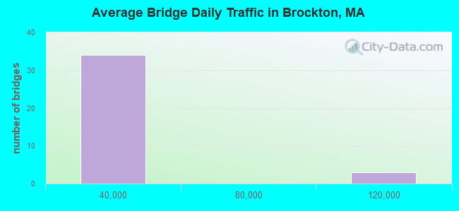
- 676,464Total average daily traffic
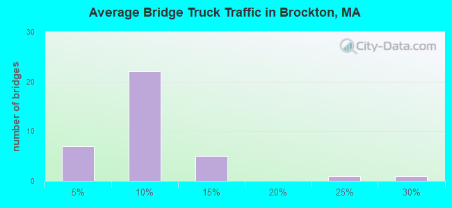
- 40,703Total average daily truck traffic
- 1,245,236Total future (year 2031) average daily traffic
- National Bridge Inventory (NBI) Registered Bridges for Brockton
- No street view available for this location
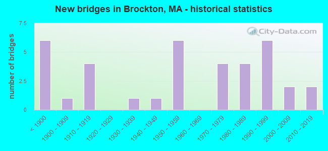
- New bridges - historical statistics
- 6Before 1900
- 11900-1909
- 41910-1919
- 11930-1939
- 11940-1949
- 61950-1959
- 41970-1979
- 41980-1989
- 61990-1999
- 22000-2009
- 22010-2019
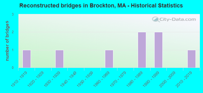
- Reconstructed bridges - Historical Statistics
- 11910-1919
- 01920-1929
- 11930-1939
- 01940-1949
- 01950-1959
- 11960-1969
- 01970-1979
- 21980-1989
- 21990-1999
- 02000-2009
- 12010-2019
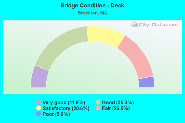
- Bridge Condition - Deck
- 11.8%Very good
- 35.3%Good
- 20.6%Satisfactory
- 26.5%Fair
- 5.9%Poor
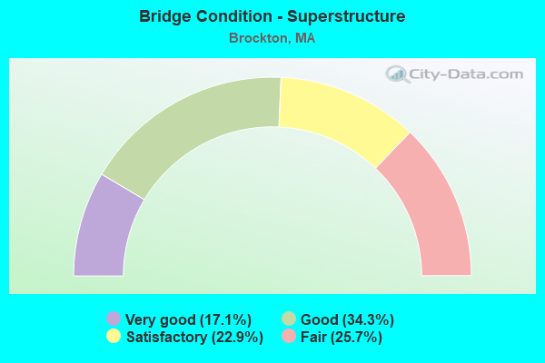
- Bridge Condition - Superstructure
- 17.1%Very good
- 34.3%Good
- 22.9%Satisfactory
- 25.7%Fair
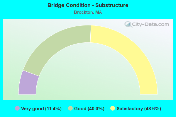
- Bridge Condition - Substructure
- 11.4%Very good
- 40.0%Good
- 48.6%Satisfactory
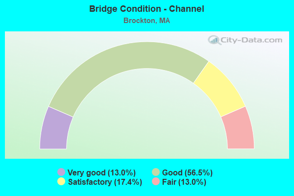
- Bridge Condition - Channel
- 13.0%Very good
- 56.5%Good
- 17.4%Satisfactory
- 13.0%Fair
Find on map >> Show street view
Structure Number: B25065456MUNNBI, Location: .1 MILE SOUTH OF OAK ST. (Lat: 42.098467, Lng: -71.043422), Route carried "on" structure: City street , Year Built: 1940, Status: Open, Structure Length: 0.79m (2.59ft), Average Daily Traffic: 1,100 (year 2021), Truck Traffic: 1%, Average Future Daily Traffic: 1,579 (year 2032), Features Intersected: WATER PORTER POND, Facility Carried by Structure: HWY DW FIELD PK
Minimum Vertical Clearance: 30+ m (98+ ft), Kilometerpoint: 1.384, Lanes on structure: 2, Owner: City or Municipal Highway Agency, Approaching Roadway Width: 5.4m (17.7ft), Skew: 2 degrees, Material/Design: Masonry, Design/Construction: Culvert, Number Of Spans In Main Unit: 2, Length of Maximum Span: 3.2m (10.5ft), Curb-To-Curb Width: 5.5m (18.0ft), Out-to-Out Width: 12.4m (40.7ft)
Condition: Channel: Good, Culverts: Good, Operating Rating: 33.3 metric tons, Method Used To Determine Operating Rating: Allowable Stress (AS), Inventory Rating: 21.4 metric tons, Method Used To Determine Inventory Rating: Allowable Stress (AS), Structural Evaluation: Somewhat better than minimum adequacy, Deck Geometry: High priority of replacement, Waterway Adequacy: Equal to present desirable criteria, Approach Roadway Alignment: Equal to present desirable criteria, Length Of Structure Improvement: 0.60m (1.97ft), Designated Inspection Frequency: Every 24 months, Inspection Date: December 2021, Bridge Improvement Cost: $171,000, Roadway Improvement Cost: $18,000, Total Project Cost: $257,000 ( Estimate for 2022)