Bridge Statistics for Benicia, California (CA)
Condition, Traffic, Stress, Structural Evaluation, Project Costs
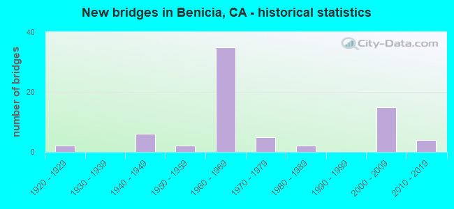
- New bridges - historical statistics
- 21920-1929
- 61940-1949
- 21950-1959
- 351960-1969
- 51970-1979
- 21980-1989
- 152000-2009
- 42010-2019
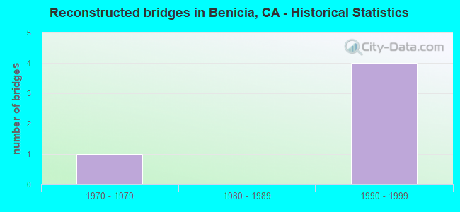
- Reconstructed bridges - Historical Statistics
- 11970-1979
- 01980-1989
- 41990-1999
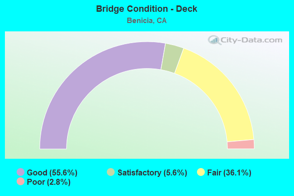
- Bridge Condition - Deck
- 55.6%Good
- 5.6%Satisfactory
- 36.1%Fair
- 2.8%Poor
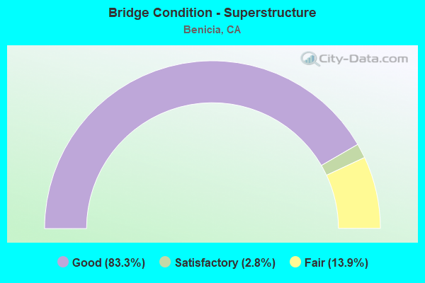
- Bridge Condition - Superstructure
- 83.3%Good
- 2.8%Satisfactory
- 13.9%Fair
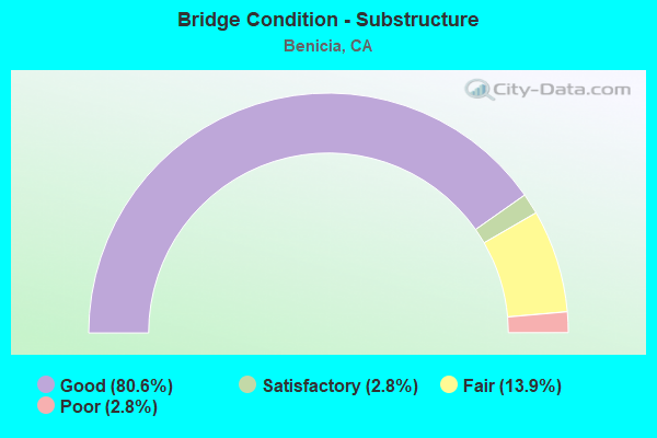
- Bridge Condition - Substructure
- 80.6%Good
- 2.8%Satisfactory
- 13.9%Fair
- 2.8%Poor
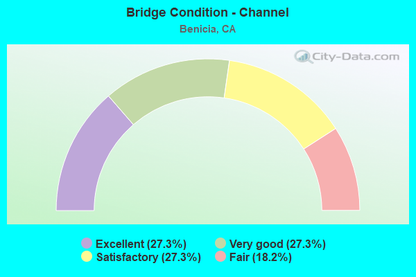
- Bridge Condition - Channel
- 27.3%Excellent
- 27.3%Very good
- 27.3%Satisfactory
- 18.2%Fair
Find on map >> Show street view
Structure Number: 23 0131L, Location: 04-SOL-780-2.96-BEN (Lat: 38.064603, Lng: -122.164289), Route carried "under" structure: City street , Year Built: 1962, Structure Length: 0. m, Average Daily Traffic: 21,000 (year 2014), Truck Traffic: 5%, Features Intersected: WEST 7TH STREET, Facility Carried by Structure: INTERSTATE 780 EB
Minimum Vertical Clearance: 5.31m (17.42ft), Kilometerpoint: 0.000, Lanes on structure: 3, Lanes under structure: 2, Material/Design: Concrete continuous, Design/Construction: Tee Beam, Length of Maximum Span: 19.2m (63.0ft)
Find on map >> Show street view
Structure Number: 23 0131R, Location: 04-SOL-780-2.96-BEN (Lat: 38.064811, Lng: -122.164228), Route carried "under" structure: City street , Year Built: 1962, Structure Length: 0. m, Average Daily Traffic: 21,000 (year 2014), Truck Traffic: 5%, Features Intersected: WEST 7TH STREET, Facility Carried by Structure: INTERSTATE 780 WB
Minimum Vertical Clearance: 4.19m (13.75ft), Kilometerpoint: 0.000, Lanes on structure: 2, Lanes under structure: 3, Material/Design: Concrete continuous, Design/Construction: Tee Beam, Length of Maximum Span: 19.2m (63.0ft)
Find on map >> Show street view
Structure Number: 23 0132L, Location: 04-SOL-780-3.81-BEN (Lat: 38.067822, Lng: -122.179553), Route carried "under" structure: City street , Year Built: 1962, Structure Length: 0. m, Average Daily Traffic: 16,800 (year 1998), Truck Traffic: 5%, Features Intersected: SOUTHAMPTON ROAD, Facility Carried by Structure: INTERSTATE 780 EB
Minimum Vertical Clearance: 5.56m (18.24ft), Kilometerpoint: 0.000, Lanes on structure: 2, Lanes under structure: 3, Material/Design: Concrete continuous, Design/Construction: Slab, Length of Maximum Span: 14.3m (46.9ft)
Find on map >> Show street view
Structure Number: 23 0132R, Location: 04-SOL-780-3.81-BEN (Lat: 38.068033, Lng: -122.179528), Route carried "under" structure: City street , Year Built: 1962, Structure Length: 0. m, Average Daily Traffic: 16,800 (year 1998), Truck Traffic: 5%, Features Intersected: SOUTHAMPTON ROAD, Facility Carried by Structure: INTERSTATE 780 WB
Minimum Vertical Clearance: 5.26m (17.26ft), Kilometerpoint: 0.000, Lanes on structure: 2, Lanes under structure: 3, Material/Design: Concrete continuous, Design/Construction: Slab, Length of Maximum Span: 14.3m (46.9ft)
Find on map >> Show street view
Structure Number: 23 0143L, Location: 04-SOL-680-R1.33-BEN (Lat: 38.064367, Lng: -122.131033), Route carried "under" structure: Business City street , Year Built: 1966, Structure Length: 0. m, Average Daily Traffic: 350 (year 2000), Truck Traffic: 10%, Features Intersected: RR, INDUSTRIAL WY, CREEK, Facility Carried by Structure: INTERSTATE 680 SB
Minimum Vertical Clearance: 8.86m (29.07ft), Kilometerpoint: 0.000, Lanes on structure: 2, Lanes under structure: 3, Material/Design: Prestressed concrete continuous, Design/Construction: Stringer/Multi-beam, Length of Maximum Span: 25.3m (83.0ft)
Find on map >> Show street view
Structure Number: 23 0143L, Location: 04-SOL-680-R1.33-BEN (Lat: 38.064367, Lng: -122.131033), Route carried "under" structure: City street , Year Built: 1966, Structure Length: 0. m, Average Daily Traffic: 4,745 (year 2001), Truck Traffic: 5%, Features Intersected: RR, INDUSTRIAL WY, CREEK, Facility Carried by Structure: INTERSTATE 680 SB
Minimum Vertical Clearance: 8.51m (27.92ft), Kilometerpoint: 0.000, Lanes on structure: 2, Lanes under structure: 2, Material/Design: Prestressed concrete continuous, Design/Construction: Stringer/Multi-beam, Length of Maximum Span: 25.3m (83.0ft)
Find on map >> Show street view
Structure Number: 23 0143R, Location: 04-SOL-680-R1.33-BEN (Lat: 38.064267, Lng: -122.130903), Route carried "under" structure: City street , Year Built: 1966, Structure Length: 0. m, Average Daily Traffic: 4,745 (year 2001), Truck Traffic: 5%, Features Intersected: RR, INDUSTRIAL WY, CREEK, Facility Carried by Structure: INTERSTATE 680 NB
Minimum Vertical Clearance: 8.78m (28.81ft), Kilometerpoint: 0.000, Lanes on structure: 2, Lanes under structure: 2, Material/Design: Prestressed concrete continuous, Design/Construction: Stringer/Multi-beam, Length of Maximum Span: 25.3m (83.0ft)
Find on map >> Show street view
Structure Number: 23 0143R, Location: 04-SOL-680-R1.33-BEN (Lat: 38.064267, Lng: -122.130903), Route carried "under" structure: City street , Year Built: 1966, Structure Length: 0. m, Average Daily Traffic: 3,000 (year 2001), Truck Traffic: 3%, Features Intersected: RR, INDUSTRIAL WY, CREEK, Facility Carried by Structure: INTERSTATE 680 NB
Minimum Vertical Clearance: 8.60m (28.22ft), Kilometerpoint: 0.000, Lanes on structure: 2, Lanes under structure: 2, Material/Design: Prestressed concrete continuous, Design/Construction: Stringer/Multi-beam, Length of Maximum Span: 25.3m (83.0ft)
Find on map >> Show street view
Structure Number: 23 0161, Location: 04-SOL-680-R5.02 (Lat: 38.115853, Lng: -122.106583), Route carried "under" structure: Interstate 680, Year Built: 1966, Structure Length: 0. m, Average Daily Traffic: 62,500 (year 2009), Features Intersected: INTERSTATE 680, Facility Carried by Structure: PARISH ROAD
Minimum Vertical Clearance: 5.18m (16.99ft), Kilometerpoint: 5.020, Lanes on structure: 2, Lanes under structure: 4, Material/Design: Concrete continuous, Design/Construction: Box Beam or Girders - Multiple, Length of Maximum Span: 30.8m (101.0ft)
Find on map >> Show street view
Structure Number: 23 0164, Location: 04-SOL-680-R2.82 (Lat: 38.085931, Lng: -122.112258), Route carried "under" structure: Interstate 680, Year Built: 1966, Structure Length: 0. m, Average Daily Traffic: 62,500 (year 2009), Truck Traffic: 5%, Features Intersected: INTERSTATE 680, Facility Carried by Structure: LAKE HERMAN ROAD
Minimum Vertical Clearance: 5.05m (16.57ft), Kilometerpoint: 2.820, Lanes on structure: 2, Lanes under structure: 4, Material/Design: Concrete continuous, Design/Construction: Box Beam or Girders - Multiple, Length of Maximum Span: 30.8m (101.0ft)
Find on map >> Show street view
Structure Number: 23 0211F, Location: 04-SOL-780-0.31L-BEN (Lat: 38.054494, Lng: -122.129242), Route carried "under" structure: Interstate 680, Year Built: 2004, Structure Length: 0. m, Average Daily Traffic: 63,000 (year 2009), Truck Traffic: 5%, Features Intersected: INTERSTATE 680 & RAMPS
Minimum Vertical Clearance: 6.95m (22.80ft), Kilometerpoint: 1.010, Lanes on structure: 2, Lanes under structure: 5, Material/Design: Prestressed concrete continuous, Design/Construction: Box Beam or Girders - Single/Spread, Length of Maximum Span: 86.3m (283.1ft)
Find on map >> Show street view
Structure Number: 23 0211F, Location: 04-SOL-780-0.31L-BEN (Lat: 38.054494, Lng: -122.129242), Route carried "under" structure: Ramp Interstate 780, Year Built: 2004, Structure Length: 0. m, Average Daily Traffic: 19,500 (year 2012), Truck Traffic: 6%, Features Intersected: INTERSTATE 680 & RAMPS
Minimum Vertical Clearance: 6.95m (22.80ft), Kilometerpoint: 0.680, Lanes on structure: 2, Lanes under structure: 2, Material/Design: Prestressed concrete continuous, Design/Construction: Box Beam or Girders - Single/Spread, Length of Maximum Span: 86.3m (283.1ft)
Find on map >> Show street view
Structure Number: 23 0211F, Location: 04-SOL-780-0.31L-BEN (Lat: 38.054494, Lng: -122.129242), Route carried "under" structure: Interstate 680, Year Built: 2004, Structure Length: 0. m, Average Daily Traffic: 63,000 (year 2009), Truck Traffic: 5%, Features Intersected: INTERSTATE 680 & RAMPS
Minimum Vertical Clearance: 15.24m (50.00ft), Kilometerpoint: 0.770, Lanes on structure: 2, Lanes under structure: 2, Material/Design: Prestressed concrete continuous, Design/Construction: Box Beam or Girders - Single/Spread, Length of Maximum Span: 86.3m (283.1ft)
Find on map >> Show street view
Structure Number: 23 0211F, Location: 04-SOL-780-0.31L-BEN (Lat: 38.054494, Lng: -122.129242), Route carried "under" structure: Ramp Interstate 780, Year Built: 2004, Structure Length: 0. m, Average Daily Traffic: 19,150 (year 2013), Truck Traffic: 6%, Features Intersected: INTERSTATE 680 & RAMPS
Minimum Vertical Clearance: 14.00m (45.93ft), Kilometerpoint: 0.680, Lanes on structure: 2, Lanes under structure: 2, Material/Design: Prestressed concrete continuous, Design/Construction: Box Beam or Girders - Single/Spread, Length of Maximum Span: 86.3m (283.1ft)
Find on map >> Show street view
Structure Number: 23 0212G, Location: 04-SOL-780-0.15R-BEN (Lat: 38.049919, Lng: -122.127464), Route carried "under" structure: City street , Year Built: 2007, Structure Length: 0. m, Average Daily Traffic: 5,000 (year 2019), Truck Traffic: 5%, Features Intersected: BAYSHORE RD & UP RR, Facility Carried by Structure: N680-W780 CONNECTR
Minimum Vertical Clearance: 8.10m (26.57ft), Kilometerpoint: 0.000, Lanes on structure: 2, Lanes under structure: 2, Material/Design: Prestressed concrete continuous, Design/Construction: Box Beam or Girders - Single/Spread, Length of Maximum Span: 56.0m (183.7ft)
Find on map >> Show street view
Structure Number: 23 0214G, Location: 04-SOL-680-N0.80R-BEN (Lat: 38.051214, Lng: -122.131758), Route carried "under" structure: Interstate 680, Year Built: 2007, Structure Length: 0. m, Average Daily Traffic: 64,000 (year 1998), Truck Traffic: 5%, Features Intersected: INTERSTATE 680 SB
Minimum Vertical Clearance: 6.70m (21.98ft), Kilometerpoint: 0.990, Lanes on structure: 2, Lanes under structure: 2, Material/Design: Prestressed concrete continuous, Design/Construction: Box Beam or Girders - Multiple, Length of Maximum Span: 48.0m (157.5ft)
Find on map >> Show street view
Structure Number: 23 0215R, Location: 04-SOL-680-N0.90R-BEN (Lat: 38.050008, Lng: -122.127267), Route carried "under" structure: City street , Year Built: 2007, Structure Length: 0. m, Average Daily Traffic: 5,000 (year 2019), Truck Traffic: 5%, Features Intersected: UP RR, BAYSHORE RD, Facility Carried by Structure: INTERSTATE 680 NB
Minimum Vertical Clearance: 8.10m (26.57ft), Kilometerpoint: 0.000, Lanes on structure: 3, Lanes under structure: 2, Material/Design: Prestressed concrete continuous, Design/Construction: Box Beam or Girders - Multiple, Length of Maximum Span: 87.5m (287.1ft)
Find on map >> Show street view
Structure Number: 23 0226R, Location: 04-SOL-780-0.49R-BEN (Lat: 38.050989, Lng: -122.134594), Route carried "under" structure: City street , Year Built: 2004, Structure Length: 0. m, Average Daily Traffic: 5,525 (year 2014), Truck Traffic: 5%, Features Intersected: PARK ROAD, Facility Carried by Structure: INTERSTATE 780 WB
Minimum Vertical Clearance: 5.94m (19.49ft), Kilometerpoint: 0.000, Lanes on structure: 3, Lanes under structure: 2, Material/Design: Prestressed concrete, Design/Construction: Box Beam or Girders - Multiple, Length of Maximum Span: 44.0m (144.4ft)
Find on map >> Show street view
Structure Number: 23 0239, Location: 04-SOL-780-4.97-BEN (Lat: 38.080083, Lng: -122.193083), Route carried "under" structure: Interstate 780, Year Built: 2010, Structure Length: 0. m, Average Daily Traffic: 64,000 (year 2000), Truck Traffic: 5%, Features Intersected: INTERSTATE 780, Facility Carried by Structure: ROSE DRIVE POC
Minimum Vertical Clearance: 5.25m (17.22ft), Kilometerpoint: 4.970, Lanes under structure: 4, Material/Design: Prestressed concrete continuous, Design/Construction: Box Beam or Girders - Multiple, Length of Maximum Span: 28.7m (94.2ft)
Find on map >> Show street view
Structure Number: 23 0255, Location: 04-SOL-780-7.07-BEN (Lat: 38.090667, Lng: -122.228389), Route carried "under" structure: Interstate 780, Year Built: 2018, Structure Length: 0. m, Average Daily Traffic: 61,000 (year 2009), Truck Traffic: 5%, Features Intersected: INTERSTATE 780, Facility Carried by Structure: LAUREL ST
Minimum Vertical Clearance: 5.13m (16.83ft), Kilometerpoint: 7.070, Lanes on structure: 2, Lanes under structure: 6, Material/Design: Prestressed concrete continuous, Design/Construction: Stringer/Multi-beam, Length of Maximum Span: 30.9m (101.4ft)
Find on map >> Show street view
Structure Number: 23C005, Location: 0.2 MI N/W OF W 7TH ST (Lat: 38.061544, Lng: -122.171703), Route carried "under" structure: City street , Year Built: 1978, Structure Length: 0. m, Average Daily Traffic: 7,160 (year 2011), Truck Traffic: 8%, Features Intersected: WEST MILITARY HWY, Facility Carried by Structure: PEDESTRIAN WALKWAY
Minimum Vertical Clearance: 4.62m (15.16ft), Kilometerpoint: 0.000, Lanes under structure: 2, Material/Design: Wood or Timber, Design/Construction: Stringer/Multi-beam, Length of Maximum Span: 23.2m (76.1ft)
Find on map >> Show street view
Structure Number: 23C0068, Location: 1.2 MI N I-780 IN BENICIA (Lat: 38.080808, Lng: -122.139953), Route carried "under" structure: City street , Year Built: 1944, Structure Length: 0. m, Average Daily Traffic: 1,577 (year 2011), Truck Traffic: 8%, Features Intersected: WEST CHANNEL ROAD, Facility Carried by Structure: EAST SECOND ST
Minimum Vertical Clearance: 6.10m (20.01ft), Kilometerpoint: 0.000, Lanes on structure: 4, Lanes under structure: 2, Material/Design: Concrete continuous, Design/Construction: Slab, Length of Maximum Span: 7.6m (24.9ft)
Find on map >> Show street view
Structure Number: 23C0156, Location: S. INDUSTRIAL HWY (Lat: 38.064228, Lng: -122.133531), Route carried "under" structure: City street , Year Built: 1975, Structure Length: 0. m, Average Daily Traffic: 3,750 (year 2005), Truck Traffic: 8%, Features Intersected: PARK ROAD, Facility Carried by Structure: PIPLINES
Minimum Vertical Clearance: 5.79m (19.00ft), Kilometerpoint: 0.000, Lanes under structure: 2, Material/Design: Steel, Length of Maximum Span: 29.0m (95.1ft)
Find on map >> Show street view
Structure Number: 23C0157, Location: SOUTH OF I-680 (Lat: 38.063722, Lng: -122.130517), Route carried "under" structure: City street , Year Built: 1925, Structure Length: 0. m, Average Daily Traffic: 500 (year 2010), Truck Traffic: 8%, Features Intersected: BAYSHORE ROAD, Facility Carried by Structure: UP RR,BNSF,AMTRAK
Minimum Vertical Clearance: 12.40m (40.68ft), Kilometerpoint: 0.000, Lanes under structure: 2, Material/Design: Steel, Design/Construction: Stringer/Multi-beam, Length of Maximum Span: 8.5m (27.9ft)
Find on map >> Show street view
Structure Number: 23C0158, Location: ADJ TO I-680 (Lat: 38.056492, Lng: -122.128131), Route carried "under" structure: City street , Year Built: 1940, Structure Length: 0. m, Average Daily Traffic: 807 (year 2011), Truck Traffic: 10%, Features Intersected: BAYSHORE ROAD, Facility Carried by Structure: UP RR,BNSF,AMTRAK
Minimum Vertical Clearance: 5.82m (19.09ft), Kilometerpoint: 0.000, Lanes under structure: 2, Material/Design: Steel, Design/Construction: Stringer/Multi-beam, Length of Maximum Span: 13.1m (43.0ft)
Find on map >> Show street view
Structure Number: 23C0159, Location: EAST OF I-680 (Lat: 38.047767, Lng: -122.127947), Route carried "under" structure: City street , Year Built: 1925, Structure Length: 0. m, Average Daily Traffic: 2,482 (year 2001), Truck Traffic: 10%, Features Intersected: BAYSHORE ROAD, Facility Carried by Structure: UP RR,BNSF,AMTRAK
Minimum Vertical Clearance: 18.90m (62.01ft), Kilometerpoint: 0.000, Lanes under structure: 2, Material/Design: Steel, Design/Construction: Stringer/Multi-beam, Length of Maximum Span: 18.3m (60.0ft)
Find on map >> Show street view
Structure Number: 23C016, Location: SOUTH WEST OF I-680 (Lat: 38.045289, Lng: -122.130058), Route carried "under" structure: City street , Year Built: 1970, Structure Length: 0. m, Average Daily Traffic: 200 (year 2010), Truck Traffic: 10%, Features Intersected: BAYSHORE ROAD & RR TRCKS, Facility Carried by Structure: PIPELINES
Minimum Vertical Clearance: 6.86m (22.51ft), Kilometerpoint: 0.000, Lanes under structure: 2, Material/Design: Steel, Length of Maximum Span: 18.3m (60.0ft)