Bridge Statistics for Benicia, California (CA)
Condition, Traffic, Stress, Structural Evaluation, Project Costs
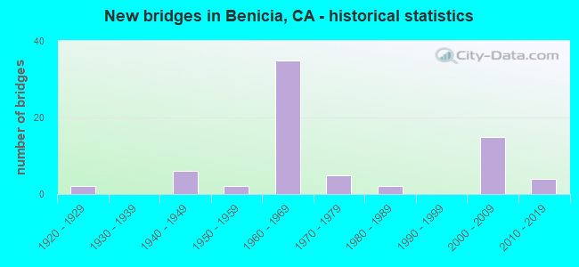
- New bridges - historical statistics
- 21920-1929
- 61940-1949
- 21950-1959
- 351960-1969
- 51970-1979
- 21980-1989
- 152000-2009
- 42010-2019
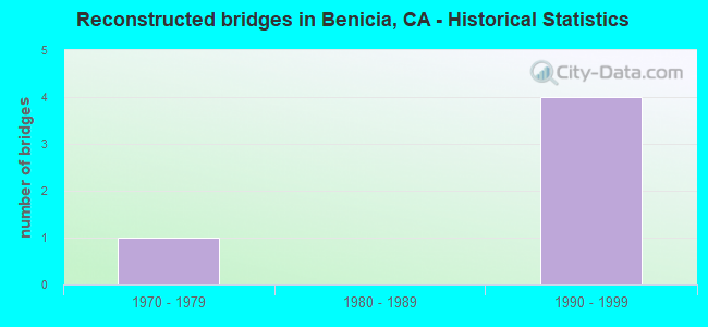
- Reconstructed bridges - Historical Statistics
- 11970-1979
- 01980-1989
- 41990-1999
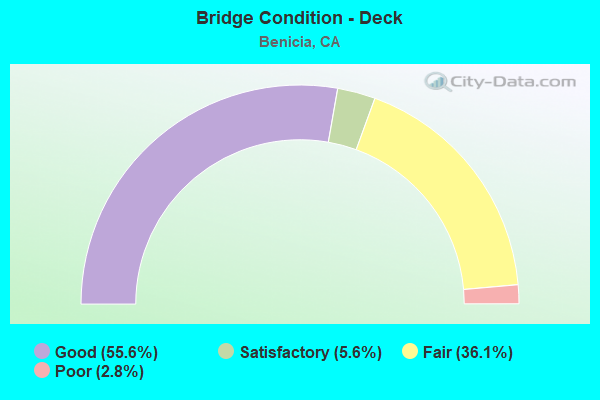
- Bridge Condition - Deck
- 55.6%Good
- 5.6%Satisfactory
- 36.1%Fair
- 2.8%Poor
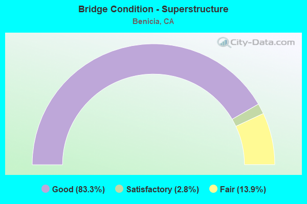
- Bridge Condition - Superstructure
- 83.3%Good
- 2.8%Satisfactory
- 13.9%Fair
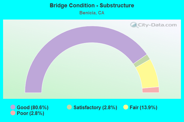
- Bridge Condition - Substructure
- 80.6%Good
- 2.8%Satisfactory
- 13.9%Fair
- 2.8%Poor
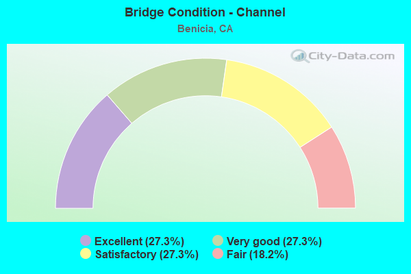
- Bridge Condition - Channel
- 27.3%Excellent
- 27.3%Very good
- 27.3%Satisfactory
- 18.2%Fair
Find on map >> Show street view
Structure Number: 23 0114, Location: 04-SOL-080-4.43-VAL (Lat: 38.122942, Lng: -122.230253), Route carried "on" structure: City street , Year Built: 1958, Year Reconstructed: 1984, Status: Open, Structure Length: 4.82m (15.81ft), Average Daily Traffic: 25,425 (year 1998), Truck Traffic: 6%, Average Future Daily Traffic: 38,902 (year 2041), Design Load: HS 20, Features Intersected: INTERSTATE 80, Facility Carried by Structure: REDWOOD ST
Minimum Vertical Clearance: 30+ m (98+ ft), Kilometerpoint: 0.000, Lanes on structure: 5, Lanes under structure: 6, Base Highway Network: Yes, Owner: State Highway Agency, Approaching Roadway Width: 22.5m (73.8ft), Skew: 23 degrees, Material/Design: Prestressed concrete, Design/Construction: Tee Beam, Number Of Spans In Main Unit: 2, Length of Maximum Span: 22.9m (75.1ft), Curb or Sidewalk Widths: Left: 1.5m (4.9ft), Right: 0.0m, Curb-To-Curb Width: 22.5m (73.8ft), Out-to-Out Width: 26.3m (86.3ft)
Condition: Deck: Good, Superstructure: Good, Substructure: Good, Operating Rating: 45.0 metric tons, Method Used To Determine Operating Rating: Load Factor (LF), Inventory Rating: 30.1 metric tons, Method Used To Determine Inventory Rating: Load Factor (LF), Structural Evaluation: Better than present minimum criteria, Deck Geometry: Equal to present minimum criteria, Underclear: High priority of corrective action, Approach Roadway Alignment: Equal to present desirable criteria, Designated Inspection Frequency: Every 24 months, Inspection Date: January 2021, Deck Structure Type: Concrete Cast-file-Place, Wearing Surface/Protective System: Wearing Surface: Bituminous
Find on map >> Show street view
Structure Number: 23 0116, Location: 04-SOL-780-4.96-BEN (Lat: 38.080056, Lng: -122.192944), Route carried "on" structure: City street , Year Built: 1960, Status: Open, Structure Length: 4.82m (15.81ft), Average Daily Traffic: 1,155 (year 2015), Truck Traffic: 2%, Average Future Daily Traffic: 1,392 (year 2042), Design Load: HS 20+Mod, Features Intersected: INTERSTATE 780, Facility Carried by Structure: ROSE DRIVE
Minimum Vertical Clearance: 30+ m (98+ ft), Kilometerpoint: 0.000, Lanes on structure: 2, Lanes under structure: 4, Owner: State Highway Agency, Approaching Roadway Width: 9.4m (30.8ft), Skew: 1 degrees, Material/Design: Prestressed concrete, Design/Construction: Tee Beam, Number Of Spans In Main Unit: 2, Length of Maximum Span: 23.2m (76.1ft), Curb or Sidewalk Widths: Left: 0.6m (2.0ft), Right: 0.6m (2.0ft), Curb-To-Curb Width: 8.5m (27.9ft), Out-to-Out Width: 10.3m (33.8ft)
Condition: Deck: Fair, Superstructure: Good, Substructure: Good, Operating Rating: 32.1 metric tons, Method Used To Determine Operating Rating: Load and Resistance Factor Rating (LRFR) rating reported by rating factor(RF) method using HL-93 loadings, Inventory Rating: 20.4 metric tons, Method Used To Determine Inventory Rating: Load and Resistance Factor Rating (LRFR) rating reported by rating factor(RF) method using HL-93 loadings, Structural Evaluation: Somewhat better than minimum adequacy, Deck Geometry: Somewhat better than minimum adequacy, Underclear: Meets minimum limits, Approach Roadway Alignment: Better than present minimum criteria, Designated Inspection Frequency: Every 24 months, Inspection Date: January 2022, Deck Structure Type: Concrete Cast-file-Place, Wearing Surface/Protective System: Wearing Surface: Bituminous
Find on map >> Show street view
Structure Number: 23 0123L, Location: 04-SOL-780-4.00-BEN (Lat: 38.068717, Lng: -122.182653), Route carried "on" structure: Interstate 780, Year Built: 1962, Status: Open, Structure Length: 4.33m (14.21ft), Average Daily Traffic: 23,500 (year 2009), Truck Traffic: 5%, Average Future Daily Traffic: 40,470 (year 2042), Design Load: HS 20+Mod, Features Intersected: W780-MILITARY-W780 RAMPS
Minimum Vertical Clearance: 30+ m (98+ ft), Kilometerpoint: 4.000, Lanes on structure: 2, Lanes under structure: 2, Base Highway Network: Yes (Inventory Route: 7, Subroute: 1), Owner: State Highway Agency, Approaching Roadway Width: 11.3m (37.1ft), Skew: 2 degrees, Material/Design: Concrete continuous, Design/Construction: Slab, Number Of Spans In Main Unit: 3, Length of Maximum Span: 14.3m (46.9ft), Curb or Sidewalk Widths: Left: 0.1m (0.3ft), Right: 0.1m (0.3ft), Curb-To-Curb Width: 11.9m (39.0ft), Out-to-Out Width: 12.7m (41.7ft)
Condition: Deck: Good, Superstructure: Good, Substructure: Good, Operating Rating: 78.7 metric tons, Method Used To Determine Operating Rating: Load Factor (LF), Inventory Rating: 47.3 metric tons, Method Used To Determine Inventory Rating: Load Factor (LF), Structural Evaluation: Better than present minimum criteria, Deck Geometry: Equal to present minimum criteria, Underclear: Equal to present minimum criteria, Approach Roadway Alignment: Equal to present desirable criteria, Designated Inspection Frequency: Every 48 months, Inspection Date: January 2020, Deck Structure Type: Concrete Cast-file-Place, Wearing Surface/Protective System: Wearing Surface: Bituminous
Find on map >> Show street view
Structure Number: 23 0123R, Location: 04-SOL-780-4.00-BEN (Lat: 38.068958, Lng: -122.182633), Route carried "on" structure: Interstate 780, Year Built: 1962, Status: Open, Structure Length: 4.33m (14.21ft), Average Daily Traffic: 23,500 (year 2009), Truck Traffic: 5%, Average Future Daily Traffic: 40,470 (year 2042), Design Load: HS 20+Mod, Features Intersected: W780-MILITARY-W780 RAMPS
Minimum Vertical Clearance: 30+ m (98+ ft), Kilometerpoint: 4.000, Lanes on structure: 2, Lanes under structure: 2, Base Highway Network: Yes (Inventory Route: 7, Subroute: 1), Owner: State Highway Agency, Approaching Roadway Width: 11.6m (38.1ft), Skew: 2 degrees, Material/Design: Concrete continuous, Design/Construction: Slab, Number Of Spans In Main Unit: 3, Length of Maximum Span: 14.3m (46.9ft), Curb or Sidewalk Widths: Left: 0.6m (2.0ft), Right: 0.1m (0.3ft), Curb-To-Curb Width: 11.9m (39.0ft), Out-to-Out Width: 13.2m (43.3ft)
Condition: Deck: Good, Superstructure: Good, Substructure: Good, Operating Rating: 79.4 metric tons, Method Used To Determine Operating Rating: Load Factor (LF), Inventory Rating: 47.6 metric tons, Method Used To Determine Inventory Rating: Load Factor (LF), Structural Evaluation: Better than present minimum criteria, Deck Geometry: Equal to present minimum criteria, Underclear: Meets minimum limits, Approach Roadway Alignment: Equal to present desirable criteria, Designated Inspection Frequency: Every 48 months, Inspection Date: January 2020, Deck Structure Type: Concrete Cast-file-Place, Wearing Surface/Protective System: Wearing Surface: Bituminous
Find on map >> Show street view
Structure Number: 23 0125L, Location: 04-SOL-780-2.01-BEN (Lat: 38.057964, Lng: -122.149789), Route carried "on" structure: Interstate 780, Year Built: 1962, Status: Open, Structure Length: 2.61m (8.56ft), Average Daily Traffic: 23,500 (year 2009), Truck Traffic: 5%, Average Future Daily Traffic: 40,202 (year 2040), Design Load: HS 20+Mod, Features Intersected: EAST 2ND STREET
Minimum Vertical Clearance: 30+ m (98+ ft), Kilometerpoint: 2.010, Lanes on structure: 2, Lanes under structure: 3, Base Highway Network: Yes (Inventory Route: 7, Subroute: 1), Owner: State Highway Agency, Approaching Roadway Width: 11.4m (37.4ft), Skew: 2 degrees, Material/Design: Prestressed concrete, Design/Construction: Tee Beam, Number Of Spans In Main Unit: 1, Length of Maximum Span: 23.7m (77.8ft), Curb-To-Curb Width: 11.4m (37.4ft), Out-to-Out Width: 12.7m (41.7ft)
Condition: Deck: Good, Superstructure: Good, Substructure: Good, Operating Rating: 28.8 metric tons, Method Used To Determine Operating Rating: Load and Resistance Factor Rating (LRFR) rating reported by rating factor(RF) method using HL-93 loadings, Inventory Rating: 18.8 metric tons, Method Used To Determine Inventory Rating: Load and Resistance Factor Rating (LRFR) rating reported by rating factor(RF) method using HL-93 loadings, Structural Evaluation: Meets minimum limits, Deck Geometry: Somewhat better than minimum adequacy, Underclear: Meets minimum limits, Approach Roadway Alignment: Equal to present desirable criteria, Designated Inspection Frequency: Every 24 months, Inspection Date: January 2022, Deck Structure Type: Concrete Cast-file-Place, Wearing Surface/Protective System: Wearing Surface: Bituminous
Find on map >> Show street view
Structure Number: 23 0125R, Location: 04-SOL-780-2.01-BEN (Lat: 38.058156, Lng: -122.149639), Route carried "on" structure: Interstate 780, Year Built: 1962, Status: Open, Structure Length: 2.61m (8.56ft), Average Daily Traffic: 23,500 (year 2009), Truck Traffic: 5%, Average Future Daily Traffic: 40,202 (year 2040), Design Load: HS 20+Mod, Features Intersected: EAST 2ND STREET
Minimum Vertical Clearance: 30+ m (98+ ft), Kilometerpoint: 2.010, Lanes on structure: 2, Lanes under structure: 3, Base Highway Network: Yes (Inventory Route: 7, Subroute: 1), Owner: State Highway Agency, Approaching Roadway Width: 11.0m (36.1ft), Skew: 2 degrees, Material/Design: Prestressed concrete, Design/Construction: Tee Beam, Number Of Spans In Main Unit: 1, Length of Maximum Span: 23.7m (77.8ft), Curb-To-Curb Width: 11.9m (39.0ft), Out-to-Out Width: 12.7m (41.7ft)
Condition: Deck: Good, Superstructure: Good, Substructure: Good, Operating Rating: 28.8 metric tons, Method Used To Determine Operating Rating: Load and Resistance Factor Rating (LRFR) rating reported by rating factor(RF) method using HL-93 loadings, Inventory Rating: 7.1 metric tons, Method Used To Determine Inventory Rating: Load and Resistance Factor Rating (LRFR) rating reported by rating factor(RF) method using HL-93 loadings, Structural Evaluation: High priority of corrective action, Deck Geometry: Equal to present minimum criteria, Underclear: Meets minimum limits, Approach Roadway Alignment: Equal to present desirable criteria, Designated Inspection Frequency: Every 24 months, Inspection Date: January 2022, Deck Structure Type: Concrete Cast-file-Place, Wearing Surface/Protective System: Wearing Surface: Bituminous
Find on map >> Show street view
Structure Number: 23 0126L, Location: 04-SOL-780-1.58-BEN (Lat: 38.052853, Lng: -122.145303), Route carried "on" structure: Interstate 780, Year Built: 1962, Status: Open, Structure Length: 2.54m (8.33ft), Average Daily Traffic: 23,500 (year 2009), Truck Traffic: 5%, Average Future Daily Traffic: 40,471 (year 2042), Design Load: HS 20, Features Intersected: EAST 5TH STREET
Minimum Vertical Clearance: 30+ m (98+ ft), Kilometerpoint: 1.580, Lanes on structure: 2, Lanes under structure: 3, Base Highway Network: Yes (Inventory Route: 7, Subroute: 1), Owner: State Highway Agency, Approaching Roadway Width: 11.3m (37.1ft), Skew: 2 degrees, Material/Design: Prestressed concrete, Design/Construction: Stringer/Multi-beam, Number Of Spans In Main Unit: 1, Length of Maximum Span: 23.7m (77.8ft), Curb-To-Curb Width: 11.9m (39.0ft), Out-to-Out Width: 12.7m (41.7ft)
Condition: Deck: Fair, Superstructure: Good, Substructure: Fair, Operating Rating: 46.7 metric tons, Method Used To Determine Operating Rating: Load and Resistance Factor Rating (LRFR) rating reported by rating factor(RF) method using HL-93 loadings, Inventory Rating: 25.9 metric tons, Method Used To Determine Inventory Rating: Load and Resistance Factor Rating (LRFR) rating reported by rating factor(RF) method using HL-93 loadings, Structural Evaluation: Somewhat better than minimum adequacy, Deck Geometry: Equal to present minimum criteria, Underclear: Meets minimum limits, Approach Roadway Alignment: Equal to present desirable criteria, Designated Inspection Frequency: Every 24 months, Inspection Date: January 2022, Deck Structure Type: Concrete Cast-file-Place, Wearing Surface/Protective System: Wearing Surface: Bituminous
Find on map >> Show street view
Structure Number: 23 0126R, Location: 04-SOL-780-1.58-BEN (Lat: 38.053042, Lng: -122.145150), Route carried "on" structure: Interstate 780, Year Built: 1962, Status: Open, Structure Length: 2.54m (8.33ft), Average Daily Traffic: 23,500 (year 2009), Truck Traffic: 5%, Average Future Daily Traffic: 40,471 (year 2042), Design Load: HS 20, Features Intersected: EAST 5TH STREET
Minimum Vertical Clearance: 30+ m (98+ ft), Kilometerpoint: 1.580, Lanes on structure: 2, Lanes under structure: 3, Base Highway Network: Yes (Inventory Route: 7, Subroute: 1), Owner: State Highway Agency, Approaching Roadway Width: 11.6m (38.1ft), Skew: 2 degrees, Material/Design: Prestressed concrete, Design/Construction: Stringer/Multi-beam, Number Of Spans In Main Unit: 1, Length of Maximum Span: 23.7m (77.8ft), Curb-To-Curb Width: 11.9m (39.0ft), Out-to-Out Width: 12.7m (41.7ft)
Condition: Deck: Fair, Superstructure: Good, Substructure: Fair, Operating Rating: 46.7 metric tons, Method Used To Determine Operating Rating: Load and Resistance Factor Rating (LRFR) rating reported by rating factor(RF) method using HL-93 loadings, Inventory Rating: 25.9 metric tons, Method Used To Determine Inventory Rating: Load and Resistance Factor Rating (LRFR) rating reported by rating factor(RF) method using HL-93 loadings, Structural Evaluation: Somewhat better than minimum adequacy, Deck Geometry: Equal to present minimum criteria, Underclear: Meets minimum limits, Approach Roadway Alignment: Equal to present desirable criteria, Designated Inspection Frequency: Every 24 months, Inspection Date: January 2022, Deck Structure Type: Concrete Cast-file-Place, Wearing Surface/Protective System: Wearing Surface: Bituminous
Find on map >> Show street view
Structure Number: 23 0127L, Location: 04-SOL-780-1.23-BEN (Lat: 38.050042, Lng: -122.139706), Route carried "on" structure: Interstate 780, Year Built: 1962, Year Reconstructed: 2004, Status: Open, Structure Length: 6.16m (20.21ft), Average Daily Traffic: 23,500 (year 2009), Truck Traffic: 5%, Average Future Daily Traffic: 40,470 (year 2042), Design Load: HS 20+Mod, Features Intersected: ACCESS ROAD
Minimum Vertical Clearance: 30+ m (98+ ft), Kilometerpoint: 1.230, Lanes on structure: 3, Base Highway Network: Yes (Inventory Route: 7, Subroute: 1), Owner: State Highway Agency, Approaching Roadway Width: 15.2m (49.9ft), Skew: 3 degrees, Material/Design: Concrete continuous, Design/Construction: Tee Beam, Number Of Spans In Main Unit: 4, Length of Maximum Span: 17.1m (56.1ft), Curb-To-Curb Width: 15.2m (49.9ft), Out-to-Out Width: 16.2m (53.1ft)
Condition: Deck: Good, Superstructure: Good, Substructure: Good, Operating Rating: 37.9 metric tons, Method Used To Determine Operating Rating: Load and Resistance Factor Rating (LRFR) rating reported by rating factor(RF) method using HL-93 loadings, Inventory Rating: 30.1 metric tons, Method Used To Determine Inventory Rating: Load and Resistance Factor Rating (LRFR) rating reported by rating factor(RF) method using HL-93 loadings, Structural Evaluation: Better than present minimum criteria, Deck Geometry: Meets minimum limits, Approach Roadway Alignment: Equal to present desirable criteria, Designated Inspection Frequency: Every 24 months, Inspection Date: January 2022, Deck Structure Type: Concrete Cast-file-Place, Wearing Surface/Protective System: Wearing Surface: Bituminous
Find on map >> Show street view
Structure Number: 23 0127R, Location: 04-SOL-780-1.23-BEN (Lat: 38.050250, Lng: -122.139942), Route carried "on" structure: Interstate 780, Year Built: 1962, Status: Open, Structure Length: 4.91m (16.11ft), Average Daily Traffic: 23,500 (year 2009), Truck Traffic: 5%, Average Future Daily Traffic: 40,470 (year 2042), Design Load: HS 20+Mod, Features Intersected: ACCESS ROAD
Minimum Vertical Clearance: 30+ m (98+ ft), Kilometerpoint: 1.230, Lanes on structure: 2, Base Highway Network: Yes (Inventory Route: 7, Subroute: 1), Owner: State Highway Agency, Approaching Roadway Width: 11.3m (37.1ft), Skew: 3 degrees, Material/Design: Concrete continuous, Design/Construction: Tee Beam, Number Of Spans In Main Unit: 3, Length of Maximum Span: 17.1m (56.1ft), Curb-To-Curb Width: 11.9m (39.0ft), Out-to-Out Width: 12.7m (41.7ft)
Condition: Deck: Good, Superstructure: Good, Substructure: Good, Operating Rating: 42.1 metric tons, Method Used To Determine Operating Rating: Load and Resistance Factor Rating (LRFR) rating reported by rating factor(RF) method using HL-93 loadings, Inventory Rating: 30.1 metric tons, Method Used To Determine Inventory Rating: Load and Resistance Factor Rating (LRFR) rating reported by rating factor(RF) method using HL-93 loadings, Structural Evaluation: Better than present minimum criteria, Deck Geometry: Equal to present minimum criteria, Approach Roadway Alignment: Equal to present desirable criteria, Designated Inspection Frequency: Every 24 months, Inspection Date: January 2022, Deck Structure Type: Concrete Cast-file-Place, Wearing Surface/Protective System: Wearing Surface: Bituminous
Find on map >> Show street view
Structure Number: 23 0128L, Location: 04-SOL-780-0.49L-BEN (Lat: 38.050517, Lng: -122.134544), Route carried "on" structure: Interstate 780, Year Built: 1962, Status: Open, Structure Length: 3.66m (12.01ft), Average Daily Traffic: 23,500 (year 2009), Truck Traffic: 5%, Average Future Daily Traffic: 40,470 (year 2042), Design Load: HS 20+Mod, Features Intersected: PARK ROAD
Minimum Vertical Clearance: 30+ m (98+ ft), Kilometerpoint: 0.490, Lanes on structure: 2, Lanes under structure: 2, Base Highway Network: Yes (Inventory Route: 7, Subroute: 1), Owner: State Highway Agency, Approaching Roadway Width: 14.6m (47.9ft), Skew: 9 degrees, Material/Design: Concrete continuous, Design/Construction: Slab, Number Of Spans In Main Unit: 3, Length of Maximum Span: 14.0m (45.9ft), Curb or Sidewalk Widths: Left: 0.0m, Right: 0.6m (2.0ft), Curb-To-Curb Width: 14.0m (45.9ft), Out-to-Out Width: 15.3m (50.2ft)
Condition: Deck: Good, Superstructure: Good, Substructure: Good, Operating Rating: 85.2 metric tons, Method Used To Determine Operating Rating: Load Factor (LF), Inventory Rating: 50.9 metric tons, Method Used To Determine Inventory Rating: Load Factor (LF), Structural Evaluation: Better than present minimum criteria, Deck Geometry: Superior to present desirable criteria, Underclear: Meets minimum limits, Approach Roadway Alignment: Better than present minimum criteria, Designated Inspection Frequency: Every 48 months, Inspection Date: January 2020, Deck Structure Type: Concrete Cast-file-Place, Wearing Surface/Protective System: Wearing Surface: Integral Concrete
Find on map >> Show street view
Structure Number: 23 0131R, Location: 04-SOL-780-2.96-BEN (Lat: 38.064811, Lng: -122.164228), Route carried "on" structure: Interstate 780, Year Built: 1962, Status: Open, Structure Length: 3.81m (12.50ft), Average Daily Traffic: 23,500 (year 2009), Truck Traffic: 5%, Average Future Daily Traffic: 40,202 (year 2040), Design Load: HS 20+Mod, Features Intersected: WEST 7TH STREET
Minimum Vertical Clearance: 30+ m (98+ ft), Kilometerpoint: 2.960, Lanes on structure: 2, Lanes under structure: 3, Base Highway Network: Yes (Inventory Route: 7, Subroute: 1), Owner: State Highway Agency, Approaching Roadway Width: 11.3m (37.1ft), Material/Design: Concrete continuous, Design/Construction: Tee Beam, Number Of Spans In Main Unit: 3, Length of Maximum Span: 19.2m (63.0ft), Curb-To-Curb Width: 11.9m (39.0ft), Out-to-Out Width: 12.7m (41.7ft)
Condition: Deck: Good, Superstructure: Good, Substructure: Good, Operating Rating: 31.4 metric tons, Method Used To Determine Operating Rating: Load and Resistance Factor Rating (LRFR) rating reported by rating factor(RF) method using HL-93 loadings, Inventory Rating: 24.3 metric tons, Method Used To Determine Inventory Rating: Load and Resistance Factor Rating (LRFR) rating reported by rating factor(RF) method using HL-93 loadings, Structural Evaluation: Equal to present minimum criteria, Deck Geometry: Equal to present minimum criteria, Underclear: High priority of corrective action, Approach Roadway Alignment: Equal to present desirable criteria, Designated Inspection Frequency: Every 24 months, Inspection Date: January 2022, Deck Structure Type: Concrete Cast-file-Place, Wearing Surface/Protective System: Wearing Surface: Bituminous
Find on map >> Show street view
Structure Number: 23 0132L, Location: 04-SOL-780-3.81-BEN (Lat: 38.067822, Lng: -122.179553), Route carried "on" structure: Interstate 780, Year Built: 1962, Status: Open, Structure Length: 3.63m (11.91ft), Average Daily Traffic: 23,500 (year 2009), Truck Traffic: 5%, Average Future Daily Traffic: 40,470 (year 2042), Design Load: HS 20+Mod, Features Intersected: SOUTHAMPTON ROAD
Minimum Vertical Clearance: 30+ m (98+ ft), Kilometerpoint: 3.810, Lanes on structure: 2, Lanes under structure: 3, Base Highway Network: Yes (Inventory Route: 7, Subroute: 1), Owner: State Highway Agency, Approaching Roadway Width: 11.3m (37.1ft), Material/Design: Concrete continuous, Design/Construction: Slab, Number Of Spans In Main Unit: 3, Length of Maximum Span: 14.3m (46.9ft), Curb-To-Curb Width: 11.9m (39.0ft), Out-to-Out Width: 12.7m (41.7ft)
Condition: Deck: Good, Superstructure: Good, Substructure: Good, Operating Rating: 55.1 metric tons, Method Used To Determine Operating Rating: Load and Resistance Factor Rating (LRFR) rating reported by rating factor(RF) method using HL-93 loadings, Inventory Rating: 42.4 metric tons, Method Used To Determine Inventory Rating: Load and Resistance Factor Rating (LRFR) rating reported by rating factor(RF) method using HL-93 loadings, Structural Evaluation: Better than present minimum criteria, Deck Geometry: Equal to present minimum criteria, Underclear: High priority of corrective action, Approach Roadway Alignment: Equal to present desirable criteria, Designated Inspection Frequency: Every 48 months, Inspection Date: January 2020, Deck Structure Type: Concrete Cast-file-Place, Wearing Surface/Protective System: Wearing Surface: Bituminous
Find on map >> Show street view
Structure Number: 23 0132R, Location: 04-SOL-780-3.81-BEN (Lat: 38.068033, Lng: -122.179528), Route carried "on" structure: Interstate 780, Year Built: 1962, Status: Open, Structure Length: 3.63m (11.91ft), Average Daily Traffic: 23,500 (year 2009), Truck Traffic: 5%, Average Future Daily Traffic: 40,470 (year 2042), Design Load: HS 20+Mod, Features Intersected: SOUTHAMPTON ROAD
Minimum Vertical Clearance: 30+ m (98+ ft), Kilometerpoint: 3.810, Lanes on structure: 2, Lanes under structure: 3, Base Highway Network: Yes (Inventory Route: 7, Subroute: 1), Owner: State Highway Agency, Approaching Roadway Width: 11.6m (38.1ft), Material/Design: Concrete continuous, Design/Construction: Slab, Number Of Spans In Main Unit: 3, Length of Maximum Span: 14.3m (46.9ft), Curb-To-Curb Width: 11.9m (39.0ft), Out-to-Out Width: 12.7m (41.7ft)
Condition: Deck: Good, Superstructure: Good, Substructure: Good, Operating Rating: 55.4 metric tons, Method Used To Determine Operating Rating: Load and Resistance Factor Rating (LRFR) rating reported by rating factor(RF) method using HL-93 loadings, Inventory Rating: 42.8 metric tons, Method Used To Determine Inventory Rating: Load and Resistance Factor Rating (LRFR) rating reported by rating factor(RF) method using HL-93 loadings, Structural Evaluation: Better than present minimum criteria, Deck Geometry: Equal to present minimum criteria, Underclear: High priority of corrective action, Approach Roadway Alignment: Equal to present desirable criteria, Designated Inspection Frequency: Every 48 months, Inspection Date: January 2020, Deck Structure Type: Concrete Cast-file-Place, Wearing Surface/Protective System: Wearing Surface: Bituminous
Find on map >> Show street view
Structure Number: 23 0143L, Location: 04-SOL-680-R1.33-BEN (Lat: 38.064367, Lng: -122.131033), Route carried "on" structure: Interstate 680, Year Built: 1966, Status: Open, Structure Length: 52.36m (171.78ft), Average Daily Traffic: 31,500 (year 2009), Truck Traffic: 5%, Average Future Daily Traffic: 44,066 (year 2040), Design Load: HS 20, Features Intersected: RR, INDUSTRIAL WY, CREEK
Minimum Vertical Clearance: 30+ m (98+ ft), Kilometerpoint: 1.330, Lanes on structure: 2, Lanes under structure: 5, Base Highway Network: Yes (Inventory Route: 6, Subroute: 1), Owner: State Highway Agency, Approaching Roadway Width: 10.4m (34.1ft), Skew: 1 degrees, Material/Design: Prestressed concrete continuous, Design/Construction: Stringer/Multi-beam, Number Of Spans In Main Unit: 21, Number Of Approach Spans: 1, Length of Maximum Span: 25.3m (83.0ft), Curb or Sidewalk Widths: Left: 0.6m (2.0ft), Right: 0.6m (2.0ft), Curb-To-Curb Width: 8.5m (27.9ft), Out-to-Out Width: 10.4m (34.1ft)
Condition: Deck: Fair, Superstructure: Good, Substructure: Fair, Channel: Excellent, Operating Rating: 34.7 metric tons, Method Used To Determine Operating Rating: Load and Resistance Factor Rating (LRFR) rating reported by rating factor(RF) method using HL-93 loadings, Inventory Rating: 26.9 metric tons, Method Used To Determine Inventory Rating: Load and Resistance Factor Rating (LRFR) rating reported by rating factor(RF) method using HL-93 loadings, Structural Evaluation: Somewhat better than minimum adequacy, Deck Geometry: High priority of corrective action, Underclear: High priority of corrective action, Waterway Adequacy: Equal to present desirable criteria, Approach Roadway Alignment: Equal to present desirable criteria, Designated Inspection Frequency: Every 24 months, Inspection Date: March 2020, Deck Structure Type: Concrete Cast-file-Place
Find on map >> Show street view
Structure Number: 23 0143R, Location: 04-SOL-680-R1.33-BEN (Lat: 38.064267, Lng: -122.130903), Route carried "on" structure: Interstate 680, Year Built: 1966, Status: Open, Structure Length: 52.36m (171.78ft), Average Daily Traffic: 31,500 (year 2009), Truck Traffic: 5%, Average Future Daily Traffic: 44,066 (year 2040), Design Load: HS 20, Features Intersected: RR, INDUSTRIAL WY, CREEK
Minimum Vertical Clearance: 30+ m (98+ ft), Kilometerpoint: 1.330, Lanes on structure: 2, Lanes under structure: 4, Base Highway Network: Yes (Inventory Route: 6, Subroute: 1), Owner: State Highway Agency, Approaching Roadway Width: 10.4m (34.1ft), Skew: 1 degrees, Material/Design: Prestressed concrete continuous, Design/Construction: Stringer/Multi-beam, Number Of Spans In Main Unit: 21, Number Of Approach Spans: 1, Length of Maximum Span: 25.3m (83.0ft), Curb or Sidewalk Widths: Left: 0.6m (2.0ft), Right: 0.6m (2.0ft), Curb-To-Curb Width: 8.5m (27.9ft), Out-to-Out Width: 10.4m (34.1ft)
Condition: Deck: Fair, Superstructure: Good, Substructure: Good, Channel: Excellent, Operating Rating: 20.7 metric tons, Method Used To Determine Operating Rating: Load and Resistance Factor Rating (LRFR) rating reported by rating factor(RF) method using HL-93 loadings, Inventory Rating: 10.7 metric tons, Method Used To Determine Inventory Rating: Load and Resistance Factor Rating (LRFR) rating reported by rating factor(RF) method using HL-93 loadings, Structural Evaluation: High priority of corrective action, Deck Geometry: High priority of corrective action, Underclear: High priority of corrective action, Waterway Adequacy: Equal to present desirable criteria, Approach Roadway Alignment: Equal to present desirable criteria, Designated Inspection Frequency: Every 24 months, Inspection Date: March 2020, Deck Structure Type: Concrete Cast-file-Place
Find on map >> Show street view
Structure Number: 23 0161, Location: 04-SOL-680-R5.02 (Lat: 38.115853, Lng: -122.106583), Route carried "on" structure: County highway , Year Built: 1966, Status: Open, Structure Length: 5.79m (19.00ft), Average Daily Traffic: 1,000 (year 1998), Truck Traffic: 7%, Average Future Daily Traffic: 1,409 (year 2042), Design Load: HS 20, Features Intersected: INTERSTATE 680, Facility Carried by Structure: PARISH ROAD
Minimum Vertical Clearance: 30+ m (98+ ft), Kilometerpoint: 0.000, Lanes on structure: 2, Lanes under structure: 4, Owner: State Highway Agency, Approaching Roadway Width: 8.8m (28.9ft), Material/Design: Concrete continuous, Design/Construction: Box Beam or Girders - Multiple, Number Of Spans In Main Unit: 2, Length of Maximum Span: 30.8m (101.0ft), Curb or Sidewalk Widths: Left: 0.6m (2.0ft), Right: 0.6m (2.0ft), Curb-To-Curb Width: 8.5m (27.9ft), Out-to-Out Width: 10.4m (34.1ft)
Condition: Deck: Fair, Superstructure: Good, Substructure: Good, Operating Rating: 43.1 metric tons, Method Used To Determine Operating Rating: Load and Resistance Factor Rating (LRFR) rating reported by rating factor(RF) method using HL-93 loadings, Inventory Rating: 33.4 metric tons, Method Used To Determine Inventory Rating: Load and Resistance Factor Rating (LRFR) rating reported by rating factor(RF) method using HL-93 loadings, Structural Evaluation: Better than present minimum criteria, Deck Geometry: Somewhat better than minimum adequacy, Underclear: High priority of corrective action, Approach Roadway Alignment: Equal to present desirable criteria, Designated Inspection Frequency: Every 24 months, Inspection Date: March 2020, Deck Structure Type: Concrete Cast-file-Place
Find on map >> Show street view
Structure Number: 23 0164, Location: 04-SOL-680-R2.82 (Lat: 38.085931, Lng: -122.112258), Route carried "on" structure: County highway , Year Built: 1966, Status: Open, Structure Length: 6.28m (20.60ft), Average Daily Traffic: 1,000 (year 1998), Truck Traffic: 7%, Average Future Daily Traffic: 1,409 (year 2042), Design Load: HS 20, Features Intersected: INTERSTATE 680, Facility Carried by Structure: LAKE HERMAN ROAD
Minimum Vertical Clearance: 30+ m (98+ ft), Kilometerpoint: 0.000, Lanes on structure: 2, Lanes under structure: 4, Owner: State Highway Agency, Approaching Roadway Width: 10.1m (33.1ft), Material/Design: Concrete continuous, Design/Construction: Box Beam or Girders - Multiple, Number Of Spans In Main Unit: 2, Length of Maximum Span: 30.8m (101.0ft), Curb or Sidewalk Widths: Left: 0.6m (2.0ft), Right: 0.6m (2.0ft), Curb-To-Curb Width: 8.5m (27.9ft), Out-to-Out Width: 10.4m (34.1ft)
Condition: Deck: Fair, Superstructure: Good, Substructure: Good, Operating Rating: 48.0 metric tons, Method Used To Determine Operating Rating: Load and Resistance Factor Rating (LRFR) rating reported by rating factor(RF) method using HL-93 loadings, Inventory Rating: 37.3 metric tons, Method Used To Determine Inventory Rating: Load and Resistance Factor Rating (LRFR) rating reported by rating factor(RF) method using HL-93 loadings, Structural Evaluation: Better than present minimum criteria, Deck Geometry: Somewhat better than minimum adequacy, Underclear: Equal to present minimum criteria, Approach Roadway Alignment: Equal to present desirable criteria, Designated Inspection Frequency: Every 24 months, Inspection Date: March 2020, Deck Structure Type: Concrete Cast-file-Place
Find on map >> Show street view
Structure Number: 23 0212G, Location: 04-SOL-780-0.15R-BEN (Lat: 38.049919, Lng: -122.127464), Route carried "on" structure: Ramp Interstate 780, Year Built: 2007, Status: Open, Structure Length: 25.83m (84.74ft), Average Daily Traffic: 52,000 (year 2014), Truck Traffic: 5%, Average Future Daily Traffic: 99,757 (year 2038), Design Load: HS 20+Mod, Features Intersected: BAYSHORE RD & UP RR
Minimum Vertical Clearance: 7.87m (25.82ft), Kilometerpoint: 0.150, Lanes on structure: 2, Lanes under structure: 2, Owner: State Highway Agency, Approaching Roadway Width: 11.7m (38.4ft), Material/Design: Prestressed concrete continuous, Design/Construction: Box Beam or Girders - Single/Spread, Number Of Spans In Main Unit: 5, Length of Maximum Span: 56.0m (183.7ft), Curb-To-Curb Width: 11.7m (38.4ft), Out-to-Out Width: 12.8m (42.0ft)
Condition: Deck: Good, Superstructure: Good, Substructure: Good, Operating Rating: 54.1 metric tons, Method Used To Determine Operating Rating: Assigned rating based on Load Factor Design (LFD) reported in metric tons, Inventory Rating: 32.4 metric tons, Method Used To Determine Inventory Rating: Assigned rating based on Load Factor Design (LFD) reported in metric tons, Structural Evaluation: Better than present minimum criteria, Deck Geometry: Superior to present desirable criteria, Underclear: Equal to present minimum criteria, Approach Roadway Alignment: Equal to present desirable criteria, Designated Inspection Frequency: Every 24 months, Inspection Date: August 2021, Deck Structure Type: Concrete Cast-file-Place
Find on map >> Show street view
Structure Number: 23 0214G, Location: 04-SOL-680-N0.80R-BEN (Lat: 38.051214, Lng: -122.131758), Route carried "on" structure: Ramp Interstate 680, Year Built: 2007, Status: Open, Structure Length: 12.00m (39.37ft), Average Daily Traffic: 51,000 (year 2000), Truck Traffic: 5%, Average Future Daily Traffic: 102,109 (year 2042), Design Load: HS 20, Features Intersected: INTERSTATE 680 SB
Minimum Vertical Clearance: 30+ m (98+ ft), Kilometerpoint: 0.800, Lanes on structure: 2, Lanes under structure: 2, Base Highway Network: Yes (Inventory Route: 7, Subroute: 1), Owner: State Highway Agency, Approaching Roadway Width: 11.8m (38.7ft), Material/Design: Prestressed concrete continuous, Design/Construction: Box Beam or Girders - Multiple, Number Of Spans In Main Unit: 3, Length of Maximum Span: 48.0m (157.5ft), Curb-To-Curb Width: 11.8m (38.7ft), Out-to-Out Width: 12.8m (42.0ft)
Condition: Deck: Good, Superstructure: Good, Substructure: Fair, Operating Rating: 54.1 metric tons, Method Used To Determine Operating Rating: Assigned rating based on Load Factor Design (LFD) reported in metric tons, Inventory Rating: 32.4 metric tons, Method Used To Determine Inventory Rating: Assigned rating based on Load Factor Design (LFD) reported in metric tons, Structural Evaluation: Somewhat better than minimum adequacy, Deck Geometry: Superior to present desirable criteria, Underclear: Equal to present minimum criteria, Approach Roadway Alignment: Equal to present desirable criteria, Designated Inspection Frequency: Every 24 months, Inspection Date: March 2020, Deck Structure Type: Concrete Cast-file-Place
Find on map >> Show street view
Structure Number: 23 0215R, Location: 04-SOL-680-N0.90R-BEN (Lat: 38.050008, Lng: -122.127267), Route carried "on" structure: Interstate 680, Year Built: 2007, Status: Open, Structure Length: 43.69m (143.34ft), Average Daily Traffic: 105,000 (year 2014), Truck Traffic: 5%, Average Future Daily Traffic: 87,838 (year 2039), Design Load: HS 20+Mod, Features Intersected: UP RR, BAYSHORE RD
Minimum Vertical Clearance: 6.47m (21.23ft), Kilometerpoint: 0.900, Lanes on structure: 3, Lanes under structure: 2, Base Highway Network: Yes (Inventory Route: 6, Subroute: 1), Owner: State Highway Agency, Approaching Roadway Width: 16.8m (55.1ft), Material/Design: Prestressed concrete continuous, Design/Construction: Box Beam or Girders - Multiple, Number Of Spans In Main Unit: 6, Length of Maximum Span: 87.5m (287.1ft), Curb-To-Curb Width: 16.8m (55.1ft), Out-to-Out Width: 17.9m (58.7ft)
Condition: Deck: Good, Superstructure: Good, Substructure: Good, Channel: Very good, Operating Rating: 54.1 metric tons, Method Used To Determine Operating Rating: Assigned rating based on Load Factor Design (LFD) reported in metric tons, Inventory Rating: 32.4 metric tons, Method Used To Determine Inventory Rating: Assigned rating based on Load Factor Design (LFD) reported in metric tons, Structural Evaluation: Better than present minimum criteria, Deck Geometry: Equal to present minimum criteria, Underclear: Equal to present minimum criteria, Waterway Adequacy: Equal to present desirable criteria, Approach Roadway Alignment: Equal to present desirable criteria, Designated Inspection Frequency: Every 24 months, Inspection Date: August 2021, Deck Structure Type: Concrete Cast-file-Place
Find on map >> Show street view
Structure Number: 23 022, Location: 04-SOL-037-R9.98-VAL (Lat: 38.142411, Lng: -122.249897), Route carried "on" structure: State highway 37, Year Built: 2005, Status: Open, Structure Length: 4.90m (16.08ft), Average Daily Traffic: 29,000 (year 2009), Truck Traffic: 25%, Average Future Daily Traffic: 61,609 (year 2040), Design Load: HS 20+Mod, Features Intersected: MINI DRIVE
Minimum Vertical Clearance: 30+ m (98+ ft), Kilometerpoint: 9.980, Lanes on structure: 6, Lanes under structure: 2, Base Highway Network: Yes (, Subroute: 1), Owner: State Highway Agency, Approaching Roadway Width: 35.0m (114.8ft), Skew: 32 degrees, Material/Design: Prestressed concrete, Design/Construction: Box Beam or Girders - Multiple, Number Of Spans In Main Unit: 1, Length of Maximum Span: 49.0m (160.8ft), Curb-To-Curb Width: 35.0m (114.8ft), Out-to-Out Width: 36.6m (120.1ft)
Condition: Deck: Fair, Superstructure: Good, Substructure: Good, Operating Rating: 54.1 metric tons, Method Used To Determine Operating Rating: Assigned rating based on Load Factor Design (LFD) reported in metric tons, Inventory Rating: 32.4 metric tons, Method Used To Determine Inventory Rating: Assigned rating based on Load Factor Design (LFD) reported in metric tons, Structural Evaluation: Better than present minimum criteria, Deck Geometry: Superior to present desirable criteria, Underclear: Somewhat better than minimum adequacy, Approach Roadway Alignment: Equal to present desirable criteria, Designated Inspection Frequency: Every 24 months, Inspection Date: January 2022, Deck Structure Type: Concrete Cast-file-Place
Find on map >> Show street view
Structure Number: 23 0226R, Location: 04-SOL-780-0.49R-BEN (Lat: 38.050989, Lng: -122.134594), Route carried "on" structure: Interstate 780, Year Built: 2004, Status: Open, Structure Length: 4.40m (14.44ft), Average Daily Traffic: 23,500 (year 2009), Truck Traffic: 5%, Average Future Daily Traffic: 40,202 (year 2040), Design Load: HS 20+Mod, Features Intersected: PARK ROAD
Minimum Vertical Clearance: 30+ m (98+ ft), Kilometerpoint: 0.490, Lanes on structure: 3, Lanes under structure: 2, Base Highway Network: Yes (Inventory Route: 7, Subroute: 1), Owner: State Highway Agency, Approaching Roadway Width: 18.1m (59.4ft), Material/Design: Prestressed concrete, Design/Construction: Box Beam or Girders - Multiple, Number Of Spans In Main Unit: 1, Length of Maximum Span: 44.0m (144.4ft), Curb-To-Curb Width: 16.8m (55.1ft), Out-to-Out Width: 19.2m (63.0ft)
Condition: Deck: Satisfactory, Superstructure: Good, Substructure: Fair, Operating Rating: 54.1 metric tons, Method Used To Determine Operating Rating: Assigned rating based on Load Factor Design (LFD) reported in metric tons, Inventory Rating: 32.4 metric tons, Method Used To Determine Inventory Rating: Assigned rating based on Load Factor Design (LFD) reported in metric tons, Structural Evaluation: Somewhat better than minimum adequacy, Deck Geometry: Equal to present minimum criteria, Underclear: Somewhat better than minimum adequacy, Approach Roadway Alignment: Better than present minimum criteria, Designated Inspection Frequency: Every 24 months, Inspection Date: January 2022, Deck Structure Type: Concrete Cast-file-Place
Find on map >> Show street view
Structure Number: 23 0234, Location: 04-SOL-012-19.07 (Lat: 38.183556, Lng: -121.808111), Route carried "on" structure: State highway 12, Year Built: 2003, Status: Open, Structure Length: 1.10m (3.61ft), Average Daily Traffic: 11,500 (year 2009), Truck Traffic: 11%, Average Future Daily Traffic: 19,318 (year 2040), Design Load: HS 20+Mod, Features Intersected: ROUND HILL CREEK
Minimum Vertical Clearance: 30+ m (98+ ft), Kilometerpoint: 19.070, Lanes on structure: 2, Base Highway Network: Yes (, Subroute: 1), Owner: State Highway Agency, Approaching Roadway Width: 19.6m (64.3ft), Skew: 2 degrees, Material/Design: Concrete, Design/Construction: Slab, Number Of Spans In Main Unit: 1, Length of Maximum Span: 11.0m (36.1ft), Curb-To-Curb Width: 19.6m (64.3ft), Out-to-Out Width: 20.7m (67.9ft)
Condition: Deck: Satisfactory, Superstructure: Satisfactory, Substructure: Good, Channel: Excellent, Operating Rating: 54.1 metric tons, Method Used To Determine Operating Rating: Assigned rating based on Load Factor Design (LFD) reported in metric tons, Inventory Rating: 32.4 metric tons, Method Used To Determine Inventory Rating: Assigned rating based on Load Factor Design (LFD) reported in metric tons, Structural Evaluation: Equal to present minimum criteria, Deck Geometry: Superior to present desirable criteria, Waterway Adequacy: Equal to present desirable criteria, Approach Roadway Alignment: Equal to present desirable criteria, Designated Inspection Frequency: Every 24 months, Inspection Date: March 2020, Deck Structure Type: Concrete Cast-file-Place
Find on map >> Show street view
Structure Number: 23 0254, Location: 04-SOL-080-32.62-VAC (Lat: 38.416431, Lng: -121.897667), Route carried "on" structure: City street , Year Built: 2018, Status: Open, Structure Length: 8.11m (26.61ft), Average Daily Traffic: 250 (year 1998), Truck Traffic: 2%, Average Future Daily Traffic: 547 (year 2042), Features Intersected: INTERSTATE 80 & RAMPS, Facility Carried by Structure: MIDWAY ROAD OC
Minimum Vertical Clearance: 30+ m (98+ ft), Kilometerpoint: 0.000, Lanes on structure: 2, Lanes under structure: 7, Base Highway Network: Yes (, Subroute: 2), Owner: State Highway Agency, Approaching Roadway Width: 12.2m (40.0ft), Skew: 2 degrees, Material/Design: Prestressed concrete continuous, Design/Construction: Box Beam or Girders - Multiple, Number Of Spans In Main Unit: 2, Length of Maximum Span: 40.5m (132.9ft), Curb or Sidewalk Widths: Left: 1.9m (6.2ft), Right: 1.9m (6.2ft), Curb-To-Curb Width: 12.2m (40.0ft), Out-to-Out Width: 16.6m (54.5ft)
Condition: Deck: Good, Superstructure: Good, Substructure: Good, Operating Rating: 54.1 metric tons, Method Used To Determine Operating Rating: Field evaluation and documented engineering judgment, Inventory Rating: 32.4 metric tons, Method Used To Determine Inventory Rating: Field evaluation and documented engineering judgment, Structural Evaluation: Better than present minimum criteria, Deck Geometry: Superior to present desirable criteria, Underclear: Equal to present minimum criteria, Approach Roadway Alignment: Equal to present desirable criteria, Designated Inspection Frequency: Every 24 months, Inspection Date: March 2020, Deck Structure Type: Concrete Cast-file-Place
Find on map >> Show street view
Structure Number: 23 0255, Location: 04-SOL-780-7.07-BEN (Lat: 38.090667, Lng: -122.228389), Route carried "on" structure: City street , Year Built: 2018, Status: Open, Structure Length: 6.18m (20.28ft), Average Daily Traffic: 3,980 (year 2008), Truck Traffic: 5%, Average Future Daily Traffic: 5,075 (year 2042), Design Load: HL 93, Features Intersected: INTERSTATE 780, Facility Carried by Structure: LAUREL ST
Minimum Vertical Clearance: 30+ m (98+ ft), Kilometerpoint: 0.000, Lanes on structure: 2, Lanes under structure: 6, Owner: State Highway Agency, Maintenance Responsibility: City or Municipal Highway Agency, Approaching Roadway Width: 9.1m (29.9ft), Skew: 1 degrees, Material/Design: Prestressed concrete continuous, Design/Construction: Stringer/Multi-beam, Number Of Spans In Main Unit: 2, Length of Maximum Span: 30.9m (101.4ft), Curb or Sidewalk Widths: Left: 1.9m (6.2ft), Right: 1.9m (6.2ft), Curb-To-Curb Width: 9.1m (29.9ft), Out-to-Out Width: 13.5m (44.3ft)
Condition: Deck: Good, Superstructure: Good, Substructure: Good, Operating Rating: 42.1 metric tons, Method Used To Determine Operating Rating: Assigned ratings based on Load and Resistance Factor Design (LRFD) reported by rating factor (RF) using HL93 loadings, Inventory Rating: 32.4 metric tons, Method Used To Determine Inventory Rating: Assigned ratings based on Load and Resistance Factor Design (LRFD) reported by rating factor (RF) using HL93 loadings, Structural Evaluation: Better than present minimum criteria, Deck Geometry: Meets minimum limits, Underclear: Equal to present minimum criteria, Approach Roadway Alignment: Equal to present desirable criteria, Designated Inspection Frequency: Every 24 months, Inspection Date: January 2022, Deck Structure Type: Concrete Cast-file-Place
Find on map >> Show street view
Structure Number: 23C0055, Location: 0.62 MI N/O ELMIRA RD (Lat: 38.360378, Lng: -121.949625), Route carried "on" structure: City street , Year Built: 1970, Year Reconstructed: 1990, Status: Open, Structure Length: 1.83m (6.00ft), Average Daily Traffic: 13,400 (year 2012), Truck Traffic: 5%, Average Future Daily Traffic: 18,424 (year 2042), Design Load: HS 20, Features Intersected: ULATIS CREEK, Facility Carried by Structure: NUT TREE RD
Minimum Vertical Clearance: 30+ m (98+ ft), Kilometerpoint: 0.000, Lanes on structure: 4, Owner: City or Municipal Highway Agency, Approaching Roadway Width: 19.5m (64.0ft), Skew: 30 degrees, Material/Design: Concrete, Design/Construction: Tee Beam, Number Of Spans In Main Unit: 1, Length of Maximum Span: 17.7m (58.1ft), Curb or Sidewalk Widths: Left: 1.5m (4.9ft), Right: 1.5m (4.9ft), Curb-To-Curb Width: 19.5m (64.0ft), Out-to-Out Width: 28.0m (91.9ft)
Condition: Deck: Good, Superstructure: Good, Substructure: Good, Channel: Very good, Operating Rating: 27.2 metric tons, Method Used To Determine Operating Rating: Load and Resistance Factor Rating (LRFR) rating reported by rating factor(RF) method using HL-93 loadings, Inventory Rating: 19.1 metric tons, Method Used To Determine Inventory Rating: Load and Resistance Factor Rating (LRFR) rating reported by rating factor(RF) method using HL-93 loadings, Structural Evaluation: Meets minimum limits, Deck Geometry: Better than present minimum criteria, Waterway Adequacy: Superior to present desirable criteria, Approach Roadway Alignment: Equal to present desirable criteria, Designated Inspection Frequency: Every 24 months, Inspection Date: October 2020, Deck Structure Type: Concrete Cast-file-Place, Wearing Surface/Protective System: Wearing Surface: Bituminous
Find on map >> Show street view
Structure Number: 23C0062, Location: 1.5 MI S BINGHAMTON RD (Lat: 38.324861, Lng: -121.758800), Route carried "on" structure: County highway , Year Built: 1959, Status: Open, Structure Length: 1.49m (4.89ft), Average Daily Traffic: 25 (year 2010), Truck Traffic: 4%, Average Future Daily Traffic: 73 (year 2043), Features Intersected: HASS SLOUGH, Facility Carried by Structure: BUNKER STATION RD
Minimum Vertical Clearance: 30+ m (98+ ft), Kilometerpoint: 0.000, Lanes on structure: 2, Owner: County Highway Agency, Approaching Roadway Width: 4.6m (15.1ft), Material/Design: Wood or Timber, Design/Construction: Stringer/Multi-beam, Number Of Spans In Main Unit: 3, Length of Maximum Span: 4.9m (16.1ft), Curb or Sidewalk Widths: Left: 0.3m (1.0ft), Right: 0.3m (1.0ft), Curb-To-Curb Width: 6.1m (20.0ft), Out-to-Out Width: 6.7m (22.0ft)
Condition: Deck: Poor, Superstructure: Good, Substructure: Poor, Channel: Fair, Operating Rating: 24.9 metric tons, Method Used To Determine Operating Rating: Allowable Stress (AS), Inventory Rating: 17.5 metric tons, Method Used To Determine Inventory Rating: Allowable Stress (AS), Structural Evaluation: Meets minimum limits, Deck Geometry: Somewhat better than minimum adequacy, Waterway Adequacy: Better than present minimum criteria, Approach Roadway Alignment: Better than present minimum criteria, Length Of Structure Improvement: 1.49m (4.89ft), Designated Inspection Frequency: Every 24 months, Inspection Date: March 2021, Bridge Improvement Cost: $230,000, Roadway Improvement Cost: $46,000, Total Project Cost: $390,000 ( Estimate for 2018), Deck Structure Type: Wood or Timber, Wearing Surface/Protective System: Wearing Surface: Bituminous
Find on map >> Show street view
Structure Number: 23C0068, Location: 1.2 MI N I-780 IN BENICIA (Lat: 38.080808, Lng: -122.139953), Route carried "on" structure: City street , Year Built: 1944, Year Reconstructed: 1995, Status: Open, Structure Length: 4.51m (14.80ft), Average Daily Traffic: 5,681 (year 2011), Truck Traffic: 5%, Average Future Daily Traffic: 5,200 (year 2038), Features Intersected: WEST CHANNEL ROAD, Facility Carried by Structure: EAST SECOND ST
Minimum Vertical Clearance: 30+ m (98+ ft), Kilometerpoint: 0.000, Lanes on structure: 4, Lanes under structure: 2, Base Highway Network: Yes, Owner: City or Municipal Highway Agency, Approaching Roadway Width: 18.3m (60.0ft), Skew: 31 degrees, Material/Design: Concrete continuous, Design/Construction: Slab, Number Of Spans In Main Unit: 8, Length of Maximum Span: 7.6m (24.9ft), Curb or Sidewalk Widths: Left: 1.8m (5.9ft), Right: 0.0m, Curb-To-Curb Width: 18.3m (60.0ft), Out-to-Out Width: 22.1m (72.5ft)
Condition: Deck: Fair, Superstructure: Fair, Substructure: Good, Operating Rating: 28.2 metric tons, Method Used To Determine Operating Rating: Field evaluation and documented engineering judgment, Inventory Rating: 16.8 metric tons, Method Used To Determine Inventory Rating: Field evaluation and documented engineering judgment, Structural Evaluation: Meets minimum limits, Deck Geometry: Somewhat better than minimum adequacy, Underclear: High priority of corrective action, Approach Roadway Alignment: Better than present minimum criteria, Designated Inspection Frequency: Every 24 months, Inspection Date: August 2020, Deck Structure Type: Concrete Cast-file-Place, Wearing Surface/Protective System: Wearing Surface: Bituminous
Find on map >> Show street view
Structure Number: 23C0069, Location: 2 KM N I-780 IN BENICIA (Lat: 38.081253, Lng: -122.139156), Route carried "on" structure: City street , Year Built: 1942, Year Reconstructed: 1995, Status: Open, Structure Length: 4.33m (14.21ft), Average Daily Traffic: 5,681 (year 2011), Truck Traffic: 5%, Average Future Daily Traffic: 5,200 (year 2038), Features Intersected: SULPHUR SPRING VALLEY CR, Facility Carried by Structure: E SECOND ST
Minimum Vertical Clearance: 30+ m (98+ ft), Kilometerpoint: 0.000, Lanes on structure: 4, Base Highway Network: Yes, Owner: City or Municipal Highway Agency, Approaching Roadway Width: 18.3m (60.0ft), Skew: 30 degrees, Material/Design: Concrete continuous, Design/Construction: Slab, Number Of Spans In Main Unit: 7, Length of Maximum Span: 8.5m (27.9ft), Curb or Sidewalk Widths: Left: 1.8m (5.9ft), Right: 0.0m, Curb-To-Curb Width: 18.3m (60.0ft), Out-to-Out Width: 22.1m (72.5ft)
Condition: Deck: Fair, Superstructure: Fair, Substructure: Good, Channel: Satisfactory, Operating Rating: 35.6 metric tons, Method Used To Determine Operating Rating: Load Factor (LF), Inventory Rating: 21.4 metric tons, Method Used To Determine Inventory Rating: Load Factor (LF), Structural Evaluation: Somewhat better than minimum adequacy, Deck Geometry: Somewhat better than minimum adequacy, Waterway Adequacy: Equal to present minimum criteria, Approach Roadway Alignment: Equal to present desirable criteria, Designated Inspection Frequency: Every 24 months, Inspection Date: August 2020, Deck Structure Type: Concrete Cast-file-Place, Wearing Surface/Protective System: Wearing Surface: Bituminous
Find on map >> Show street view
Structure Number: 23C015, Location: NEAR I-80 & I-680 (Lat: 38.217150, Lng: -122.136067), Route carried "on" structure: City street , Year Built: 1970, Status: Open, Structure Length: 3.47m (11.38ft), Average Daily Traffic: 3,980 (year 2010), Truck Traffic: 4%, Average Future Daily Traffic: 4,591 (year 2041), Design Load: HS 20, Features Intersected: GREEN VALLEY CREEK, Facility Carried by Structure: CENT WAY PITTMAN
Minimum Vertical Clearance: 30+ m (98+ ft), Kilometerpoint: 0.000, Lanes on structure: 2, Owner: City or Municipal Highway Agency, Approaching Roadway Width: 8.5m (27.9ft), Skew: 5 degrees, Material/Design: Concrete, Design/Construction: Tee Beam, Number Of Spans In Main Unit: 3, Length of Maximum Span: 14.9m (48.9ft), Curb-To-Curb Width: 8.5m (27.9ft), Out-to-Out Width: 9.1m (29.9ft)
Condition: Deck: Fair, Superstructure: Fair, Substructure: Good, Channel: Very good, Operating Rating: 36.3 metric tons, Method Used To Determine Operating Rating: Load and Resistance Factor Rating (LRFR) rating reported by rating factor(RF) method using HL-93 loadings, Inventory Rating: 27.9 metric tons, Method Used To Determine Inventory Rating: Load and Resistance Factor Rating (LRFR) rating reported by rating factor(RF) method using HL-93 loadings, Structural Evaluation: Somewhat better than minimum adequacy, Deck Geometry: Meets minimum limits, Waterway Adequacy: Superior to present desirable criteria, Approach Roadway Alignment: Better than present minimum criteria, Designated Inspection Frequency: Every 24 months, Inspection Date: December 2021, Deck Structure Type: Concrete Cast-file-Place
Find on map >> Show street view
Structure Number: 23C0155, Location: 0.12 MI N/E BAYSHORE RD (Lat: 38.066531, Lng: -122.129972), Route carried "on" structure: City street , Year Built: 1988, Status: Open, Structure Length: 2.23m (7.32ft), Average Daily Traffic: 9,854 (year 2011), Truck Traffic: 8%, Average Future Daily Traffic: 8,161 (year 2040), Design Load: HS 20+Mod, Features Intersected: SULPHUR SPRINGS CREEK, Facility Carried by Structure: PARK ROAD
Minimum Vertical Clearance: 30+ m (98+ ft), Kilometerpoint: 0.000, Lanes on structure: 3, Owner: City or Municipal Highway Agency, Approaching Roadway Width: 9.8m (32.2ft), Skew: 1 degrees, Material/Design: Concrete continuous, Design/Construction: Slab, Number Of Spans In Main Unit: 3, Length of Maximum Span: 8.5m (27.9ft), Curb-To-Curb Width: 17.1m (56.1ft), Out-to-Out Width: 18.1m (59.4ft)
Condition: Deck: Fair, Superstructure: Fair, Substructure: Satisfactory, Channel: Satisfactory, Operating Rating: 42.1 metric tons, Method Used To Determine Operating Rating: Load and Resistance Factor Rating (LRFR) rating reported by rating factor(RF) method using HL-93 loadings, Inventory Rating: 32.4 metric tons, Method Used To Determine Inventory Rating: Load and Resistance Factor Rating (LRFR) rating reported by rating factor(RF) method using HL-93 loadings, Structural Evaluation: Somewhat better than minimum adequacy, Deck Geometry: Superior to present desirable criteria, Waterway Adequacy: Equal to present minimum criteria, Approach Roadway Alignment: Equal to present desirable criteria, Designated Inspection Frequency: Every 24 months, Inspection Date: August 2020, Deck Structure Type: Concrete Cast-file-Place
Find on map >> Show street view
Structure Number: 23C0161, Location: 0.2 MI W GREEN VALLEY RD (Lat: 38.235983, Lng: -122.156083), Route carried "on" structure: County highway , Year Built: 1980, Status: Open, Structure Length: 2.87m (9.42ft), Average Daily Traffic: 229 (year 2004), Truck Traffic: 1%, Average Future Daily Traffic: 452 (year 2042), Design Load: HS 20, Features Intersected: GREEN VALLEY CREEK, Facility Carried by Structure: MASON ROAD
Minimum Vertical Clearance: 30+ m (98+ ft), Kilometerpoint: 0.000, Lanes on structure: 2, Owner: County Highway Agency, Approaching Roadway Width: 6.4m (21.0ft), Skew: 1 degrees, Material/Design: Concrete continuous, Design/Construction: Tee Beam, Number Of Spans In Main Unit: 2, Length of Maximum Span: 14.0m (45.9ft), Curb or Sidewalk Widths: Left: 0.4m (1.3ft), Right: 0.4m (1.3ft), Curb-To-Curb Width: 7.8m (25.6ft), Out-to-Out Width: 9.1m (29.9ft)
Condition: Deck: Good, Superstructure: Good, Substructure: Good, Channel: Satisfactory, Operating Rating: 75.2 metric tons, Method Used To Determine Operating Rating: Load Factor (LF), Inventory Rating: 45.0 metric tons, Method Used To Determine Inventory Rating: Load Factor (LF), Structural Evaluation: Better than present minimum criteria, Deck Geometry: Somewhat better than minimum adequacy, Waterway Adequacy: Better than present minimum criteria, Approach Roadway Alignment: Equal to present desirable criteria, Designated Inspection Frequency: Every 48 months, Inspection Date: August 2020, Deck Structure Type: Concrete Cast-file-Place
Find on map >> Show street view
Structure Number: 23C0212, Location: POLK ST (Lat: 38.046122, Lng: -122.137819), Route carried "on" structure: City street , Year Built: 1943, Status: Open, Structure Length: 1.13m (3.71ft), Average Daily Traffic: 2,561 (year 2011), Truck Traffic: 8%, Average Future Daily Traffic: 2,661 (year 2040), Features Intersected: POLK ST, Facility Carried by Structure: GRANT STREET
Minimum Vertical Clearance: 30+ m (98+ ft), Kilometerpoint: 0.000, Lanes on structure: 2, Lanes under structure: 2, Owner: City or Municipal Highway Agency, Approaching Roadway Width: 9.8m (32.2ft), Material/Design: Concrete, Design/Construction: Slab, Number Of Spans In Main Unit: 1, Length of Maximum Span: 10.4m (34.1ft), Curb or Sidewalk Widths: Left: 1.3m (4.3ft), Right: 1.3m (4.3ft), Curb-To-Curb Width: 9.8m (32.2ft), Out-to-Out Width: 12.8m (42.0ft)
Condition: Deck: Fair, Superstructure: Fair, Substructure: Good, Operating Rating: 25.9 metric tons, Method Used To Determine Operating Rating: Field evaluation and documented engineering judgment, Inventory Rating: 15.6 metric tons, Method Used To Determine Inventory Rating: Field evaluation and documented engineering judgment, Structural Evaluation: Meets minimum limits, Deck Geometry: Meets minimum limits, Underclear: Meets minimum limits, Approach Roadway Alignment: Equal to present desirable criteria, Designated Inspection Frequency: Every 24 months, Inspection Date: August 2020, Deck Structure Type: Concrete Cast-file-Place, Wearing Surface/Protective System: Wearing Surface: Bituminous
Find on map >> Show street view
Structure Number: 23C0213, Location: 0.2 MI S OF 2ND ST (Lat: 38.079369, Lng: -122.137858), Route carried "on" structure: City street , Year Built: 1943, Status: Open, Structure Length: 1.89m (6.20ft), Average Daily Traffic: 1,578 (year 2011), Truck Traffic: 10%, Average Future Daily Traffic: 3,150 (year 2038), Features Intersected: SULPHUR SPRING VALLEY CR, Facility Carried by Structure: WEST CHANNEL RD
Minimum Vertical Clearance: 30+ m (98+ ft), Kilometerpoint: 0.000, Lanes on structure: 2, Owner: City or Municipal Highway Agency, Approaching Roadway Width: 7.3m (24.0ft), Material/Design: Concrete continuous, Design/Construction: Slab, Number Of Spans In Main Unit: 3, Length of Maximum Span: 6.1m (20.0ft), Curb or Sidewalk Widths: Left: 0.3m (1.0ft), Right: 0.3m (1.0ft), Curb-To-Curb Width: 8.0m (26.2ft), Out-to-Out Width: 8.6m (28.2ft)
Condition: Deck: Good, Superstructure: Good, Substructure: Good, Channel: Fair, Operating Rating: 27.9 metric tons, Method Used To Determine Operating Rating: Field evaluation and documented engineering judgment, Inventory Rating: 16.8 metric tons, Method Used To Determine Inventory Rating: Field evaluation and documented engineering judgment, Structural Evaluation: Meets minimum limits, Deck Geometry: Meets minimum limits, Waterway Adequacy: Better than present minimum criteria, Approach Roadway Alignment: Meets minimum limits, Designated Inspection Frequency: Every 24 months, Inspection Date: August 2020, Deck Structure Type: Concrete Cast-file-Place, Wearing Surface/Protective System: Wearing Surface: Bituminous
Find on map >> Show street view
Structure Number: 23C0283, Location: 0.2 MI SOUTH OF I-680 (Lat: 38.084744, Lng: -122.109844), Route carried "on" structure: Business City street , Year Built: 2000, Status: Open, Structure Length: 4.80m (15.75ft), Average Daily Traffic: 400 (year 2010), Truck Traffic: 5%, Average Future Daily Traffic: 612 (year 2040), Features Intersected: RAIL ROAD, Facility Carried by Structure: LAKE HERMAN ROAD
Minimum Vertical Clearance: 30+ m (98+ ft), Kilometerpoint: 0.000, Lanes on structure: 2, Owner: City or Municipal Highway Agency, Approaching Roadway Width: 11.0m (36.1ft), Material/Design: Concrete, Design/Construction: Tee Beam, Number Of Spans In Main Unit: 3, Length of Maximum Span: 17.0m (55.8ft), Curb or Sidewalk Widths: Left: 0.6m (2.0ft), Right: 0.6m (2.0ft), Curb-To-Curb Width: 8.8m (28.9ft), Out-to-Out Width: 10.7m (35.1ft)
Condition: Deck: Good, Superstructure: Good, Substructure: Good, Operating Rating: 54.1 metric tons, Method Used To Determine Operating Rating: Field evaluation and documented engineering judgment, Inventory Rating: 32.4 metric tons, Method Used To Determine Inventory Rating: Field evaluation and documented engineering judgment, Structural Evaluation: Better than present minimum criteria, Deck Geometry: Equal to present minimum criteria, Underclear: Equal to present minimum criteria, Approach Roadway Alignment: Equal to present desirable criteria, Designated Inspection Frequency: Every 48 months, Inspection Date: August 2018, Deck Structure Type: Concrete Cast-file-Place, Wearing Surface/Protective System: Wearing Surface: Bituminous
Find on map >> Show street view
Structure Number: 23 0116, Location: 04-SOL-780-4.96-BEN (Lat: 38.080056, Lng: -122.192944), Route carried "under" structure: Interstate 780, Year Built: 1960, Structure Length: 0. m, Average Daily Traffic: 61,000 (year 2009), Truck Traffic: 5%, Features Intersected: INTERSTATE 780, Facility Carried by Structure: ROSE DRIVE
Minimum Vertical Clearance: 5.13m (16.83ft), Kilometerpoint: 4.960, Lanes on structure: 2, Lanes under structure: 4, Material/Design: Prestressed concrete, Design/Construction: Tee Beam, Length of Maximum Span: 23.2m (76.1ft)
Find on map >> Show street view
Structure Number: 23 0123L, Location: 04-SOL-780-4.00-BEN (Lat: 38.068717, Lng: -122.182653), Route carried "under" structure: Ramp Interstate 780, Year Built: 1962, Structure Length: 0. m, Average Daily Traffic: 3,300 (year 2013), Truck Traffic: 5%, Features Intersected: W780-MILITARY-W780 RAMPS
Minimum Vertical Clearance: 6.30m (20.67ft), Kilometerpoint: 4.000, Lanes on structure: 2, Lanes under structure: 2, Material/Design: Concrete continuous, Design/Construction: Slab, Length of Maximum Span: 14.3m (46.9ft)
Find on map >> Show street view
Structure Number: 23 0123R, Location: 04-SOL-780-4.00-BEN (Lat: 38.068958, Lng: -122.182633), Route carried "under" structure: Ramp Interstate 780, Year Built: 1962, Structure Length: 0. m, Average Daily Traffic: 3,300 (year 2013), Truck Traffic: 5%, Features Intersected: W780-MILITARY-W780 RAMPS
Minimum Vertical Clearance: 4.70m (15.42ft), Kilometerpoint: 4.000, Lanes on structure: 2, Lanes under structure: 2, Material/Design: Concrete continuous, Design/Construction: Slab, Length of Maximum Span: 14.3m (46.9ft)
Find on map >> Show street view
Structure Number: 23 0125L, Location: 04-SOL-780-2.01-BEN (Lat: 38.057964, Lng: -122.149789), Route carried "under" structure: City street , Year Built: 1962, Structure Length: 0. m, Average Daily Traffic: 8,750 (year 2014), Truck Traffic: 5%, Features Intersected: EAST 2ND STREET, Facility Carried by Structure: INTERSTATE 780 EB
Minimum Vertical Clearance: 4.62m (15.16ft), Kilometerpoint: 0.000, Lanes on structure: 2, Lanes under structure: 3, Material/Design: Prestressed concrete, Design/Construction: Tee Beam, Length of Maximum Span: 23.7m (77.8ft)
Find on map >> Show street view
Structure Number: 23 0125R, Location: 04-SOL-780-2.01-BEN (Lat: 38.058156, Lng: -122.149639), Route carried "under" structure: City street , Year Built: 1962, Structure Length: 0. m, Average Daily Traffic: 8,750 (year 2014), Truck Traffic: 5%, Features Intersected: EAST 2ND STREET, Facility Carried by Structure: INTERSTATE 780 WB
Minimum Vertical Clearance: 4.78m (15.68ft), Kilometerpoint: 0.000, Lanes on structure: 2, Lanes under structure: 3, Material/Design: Prestressed concrete, Design/Construction: Tee Beam, Length of Maximum Span: 23.7m (77.8ft)
Find on map >> Show street view
Structure Number: 23 0126L, Location: 04-SOL-780-1.58-BEN (Lat: 38.052853, Lng: -122.145303), Route carried "under" structure: City street , Year Built: 1962, Structure Length: 0. m, Average Daily Traffic: 6,335 (year 1998), Truck Traffic: 5%, Features Intersected: EAST 5TH STREET, Facility Carried by Structure: INTERSTATE 780 EB
Minimum Vertical Clearance: 6.25m (20.51ft), Kilometerpoint: 0.000, Lanes on structure: 2, Lanes under structure: 3, Material/Design: Prestressed concrete, Design/Construction: Stringer/Multi-beam, Length of Maximum Span: 23.7m (77.8ft)
Find on map >> Show street view
Structure Number: 23 0126R, Location: 04-SOL-780-1.58-BEN (Lat: 38.053042, Lng: -122.145150), Route carried "under" structure: City street , Year Built: 1962, Structure Length: 0. m, Average Daily Traffic: 6,335 (year 1998), Truck Traffic: 5%, Features Intersected: EAST 5TH STREET, Facility Carried by Structure: INTERSTATE 780 WB
Minimum Vertical Clearance: 5.33m (17.49ft), Kilometerpoint: 0.000, Lanes on structure: 2, Lanes under structure: 3, Material/Design: Prestressed concrete, Design/Construction: Stringer/Multi-beam, Length of Maximum Span: 23.7m (77.8ft)
Find on map >> Show street view
Structure Number: 23 0128L, Location: 04-SOL-780-0.49L-BEN (Lat: 38.050517, Lng: -122.134544), Route carried "under" structure: City street , Year Built: 1962, Structure Length: 0. m, Average Daily Traffic: 5,525 (year 2014), Truck Traffic: 5%, Features Intersected: PARK ROAD, Facility Carried by Structure: INTERSTATE 780 EB
Minimum Vertical Clearance: 5.44m (17.85ft), Kilometerpoint: 0.000, Lanes on structure: 2, Lanes under structure: 2, Material/Design: Concrete continuous, Design/Construction: Slab, Length of Maximum Span: 14.0m (45.9ft)