Bridge Statistics for Bakersfield, California (CA)
Condition, Traffic, Stress, Structural Evaluation, Project Costs
- National Bridge Inventory (NBI) Statistics
- 401Number of bridges
- 5,013ft / 1,528mTotal length
- $18,821,000Total costs
- 9,611,257Total average daily traffic
- 1,292,895Total average daily truck traffic
- National Bridge Inventory (NBI) Registered Bridges for Bakersfield
- No street view available for this location
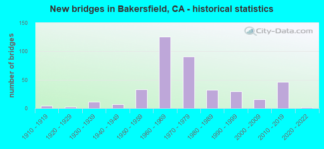
- New bridges - historical statistics
- 41910-1919
- 31920-1929
- 111930-1939
- 71940-1949
- 331950-1959
- 1261960-1969
- 911970-1979
- 321980-1989
- 301990-1999
- 162000-2009
- 462010-2019
- 22020-2022
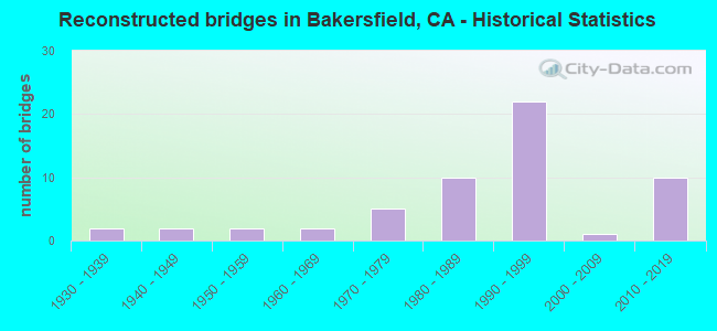
- Reconstructed bridges - Historical Statistics
- 21930-1939
- 21940-1949
- 21950-1959
- 21960-1969
- 51970-1979
- 101980-1989
- 221990-1999
- 12000-2009
- 102010-2019
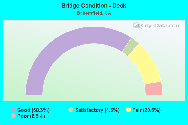
- Bridge Condition - Deck
- 68.3%Good
- 4.5%Satisfactory
- 20.6%Fair
- 6.5%Poor
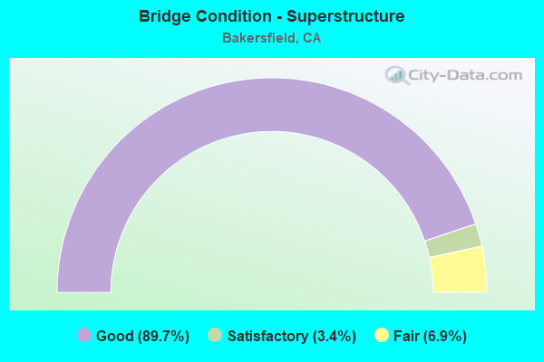
- Bridge Condition - Superstructure
- 89.7%Good
- 3.4%Satisfactory
- 6.9%Fair
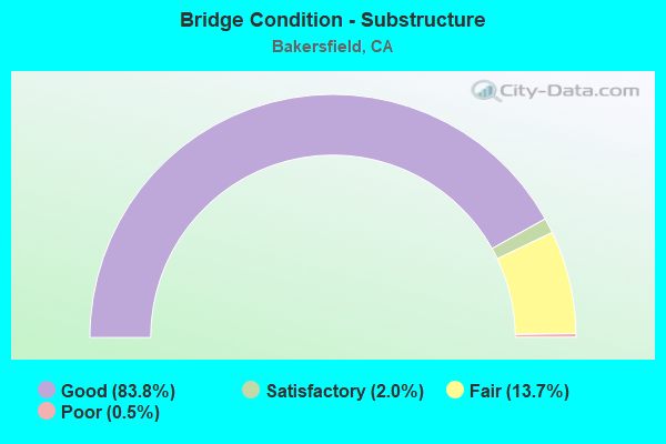
- Bridge Condition - Substructure
- 83.8%Good
- 2.0%Satisfactory
- 13.7%Fair
- 0.5%Poor
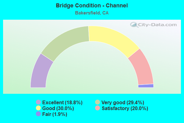
- Bridge Condition - Channel
- 18.8%Excellent
- 29.4%Very good
- 30.0%Good
- 20.0%Satisfactory
- 1.9%Fair
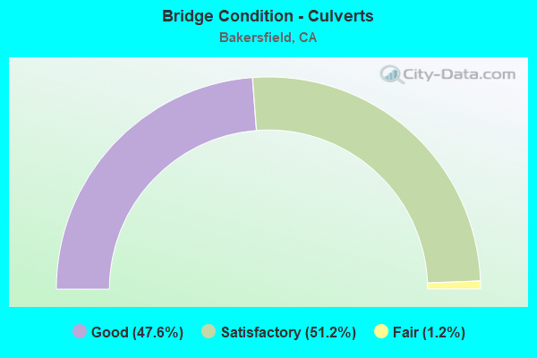
- Bridge Condition - Culverts
- 47.6%Good
- 51.2%Satisfactory
- 1.2%Fair
Find on map >> Show street view
Structure Number: 50 0426F, Location: 06-KER-058-T52.33 (Lat: 35.352747, Lng: -119.040006), Route carried "under" structure: State highway 99, Year Built: 1976, Structure Length: 0. m, Average Daily Traffic: 145,000 (year 2016), Truck Traffic: 23%, Features Intersected: SR 99 & WIBLE ROAD
Minimum Vertical Clearance: 6.32m (20.73ft), Kilometerpoint: 23.520, Lanes on structure: 2, Lanes under structure: 10, Material/Design: Prestressed concrete continuous, Design/Construction: Box Beam or Girders - Multiple, Length of Maximum Span: 39.6m (129.9ft)
Find on map >> Show street view
Structure Number: 50 0426F, Location: 06-KER-058-T52.33 (Lat: 35.352747, Lng: -119.040006), Route carried "under" structure: County highway F289, Year Built: 1976, Structure Length: 0. m, Average Daily Traffic: 20,000 (year 2016), Truck Traffic: 4%, Features Intersected: SR 99 & WIBLE ROAD, Facility Carried by Structure: W58-S99 CONNECTOR
Minimum Vertical Clearance: 5.18m (16.99ft), Kilometerpoint: 0.000, Lanes on structure: 2, Lanes under structure: 4, Material/Design: Prestressed concrete continuous, Design/Construction: Box Beam or Girders - Multiple, Length of Maximum Span: 39.6m (129.9ft)
Find on map >> Show street view
Structure Number: 50 0426S, Location: 06-KER-058-T52.33 (Lat: 35.352517, Lng: -119.039994), Route carried "under" structure: State highway 99, Year Built: 1976, Structure Length: 0. m, Average Daily Traffic: 140,000 (year 2016), Truck Traffic: 23%, Features Intersected: SR 99 & WIBLE ROAD, Facility Carried by Structure: REAL RD-E58 ON RMP
Minimum Vertical Clearance: 6.32m (20.73ft), Kilometerpoint: 23.510, Lanes on structure: 2, Lanes under structure: 10, Material/Design: Prestressed concrete continuous, Design/Construction: Box Beam or Girders - Multiple, Length of Maximum Span: 39.6m (129.9ft)
Find on map >> Show street view
Structure Number: 50 0426S, Location: 06-KER-058-T52.33 (Lat: 35.352517, Lng: -119.039994), Route carried "under" structure: County highway F289, Year Built: 1976, Structure Length: 0. m, Average Daily Traffic: 19,000 (year 2016), Truck Traffic: 4%, Features Intersected: SR 99 & WIBLE ROAD, Facility Carried by Structure: REAL RD-E58 ON RMP
Minimum Vertical Clearance: 5.68m (18.64ft), Kilometerpoint: 0.000, Lanes on structure: 2, Lanes under structure: 4, Material/Design: Prestressed concrete continuous, Design/Construction: Box Beam or Girders - Multiple, Length of Maximum Span: 39.6m (129.9ft)
Find on map >> Show street view
Structure Number: 50 0429F, Location: 06-KER-099-23.49-BKD (Lat: 35.352325, Lng: -119.036919), Route carried "under" structure: State highway 99, Year Built: 1976, Structure Length: 0. m, Average Daily Traffic: 120,000 (year 2018), Truck Traffic: 2%, Features Intersected: SR 58, SR 99 & WIBLE RD
Minimum Vertical Clearance: 10.67m (35.01ft), Kilometerpoint: 23.490, Lanes on structure: 2, Lanes under structure: 6, Material/Design: Prestressed concrete continuous, Design/Construction: Box Beam or Girders - Multiple, Length of Maximum Span: 63.9m (209.6ft)
Find on map >> Show street view
Structure Number: 50 0429F, Location: 06-KER-099-23.49-BKD (Lat: 35.352325, Lng: -119.036919), Route carried "under" structure: State highway 58, Year Built: 1976, Structure Length: 0. m, Average Daily Traffic: 40,500 (year 2018), Truck Traffic: 29%, Features Intersected: SR 58, SR 99 & WIBLE RD
Minimum Vertical Clearance: 5.08m (16.67ft), Kilometerpoint: 52.340, Lanes on structure: 2, Lanes under structure: 4, Material/Design: Prestressed concrete continuous, Design/Construction: Box Beam or Girders - Multiple, Length of Maximum Span: 63.9m (209.6ft)
Find on map >> Show street view
Structure Number: 50 0432F, Location: 06-KER-058-R52.38-BKD (Lat: 35.353964, Lng: -119.038542), Route carried "under" structure: Ramp State highway 58, Year Built: 1976, Structure Length: 0. m, Average Daily Traffic: 16,000 (year 2016), Truck Traffic: 12%, Features Intersected: W58-N99 CONNECTOR RAMP, Facility Carried by Structure: BRUNDAGE LN & OAK
Minimum Vertical Clearance: 4.90m (16.08ft), Kilometerpoint: 52.380, Lanes on structure: 5, Lanes under structure: 2, Material/Design: Concrete, Design/Construction: Frame, Length of Maximum Span: 73.2m (240.2ft)
Find on map >> Show street view
Structure Number: 50 0503, Location: 06-KER-178-R6.77-BKD (Lat: 35.396967, Lng: -118.930039), Route carried "under" structure: State highway 178, Year Built: 2009, Structure Length: 0. m, Average Daily Traffic: 26,500 (year 2009), Truck Traffic: 8%, Features Intersected: STATE ROUTE 178, Facility Carried by Structure: FAIRFAX ROAD
Minimum Vertical Clearance: 5.10m (16.73ft), Kilometerpoint: 6.770, Lanes on structure: 6, Lanes under structure: 4, Material/Design: Prestressed concrete continuous, Design/Construction: Box Beam or Girders - Multiple, Length of Maximum Span: 44.9m (147.3ft)
Find on map >> Show street view
Structure Number: 50 0505, Location: 06-KER-204-4.88-BKD (Lat: 35.386550, Lng: -119.017975), Route carried "under" structure: City street , Year Built: 2011, Structure Length: 0. m, Average Daily Traffic: 24,103 (year 2014), Truck Traffic: 5%, Features Intersected: CHESTER AVE, Facility Carried by Structure: SR 204 (GOLDEN ST)
Minimum Vertical Clearance: 4.52m (14.83ft), Kilometerpoint: 0.000, Lanes on structure: 4, Lanes under structure: 4, Material/Design: Prestressed concrete, Design/Construction: Stringer/Multi-beam, Length of Maximum Span: 24.1m (79.1ft)
Find on map >> Show street view
Structure Number: 50 0507, Location: 06-KER-099-18.52-BKD (Lat: 35.281417, Lng: -119.026889), Route carried "under" structure: State highway 99, Year Built: 2015, Structure Length: 0. m, Average Daily Traffic: 66,500 (year 2019), Truck Traffic: 24%, Features Intersected: STATE ROUTE 99, Facility Carried by Structure: HOSKING AVENUE
Minimum Vertical Clearance: 5.54m (18.18ft), Kilometerpoint: 18.520, Lanes on structure: 6, Lanes under structure: 8, Material/Design: Prestressed concrete continuous, Design/Construction: Box Beam or Girders - Multiple, Length of Maximum Span: 47.6m (156.2ft)
Find on map >> Show street view
Structure Number: 50 0516, Location: 06-KER-178-R7.00 (Lat: 35.397017, Lng: -118.913322), Route carried "under" structure: State highway 178, Year Built: 2015, Structure Length: 0. m, Average Daily Traffic: 26,500 (year 2009), Truck Traffic: 8%, Features Intersected: STATE ROUTE 178, Facility Carried by Structure: MORNING DRIVE
Minimum Vertical Clearance: 5.21m (17.09ft), Kilometerpoint: 7.000, Lanes on structure: 6, Lanes under structure: 6, Material/Design: Prestressed concrete continuous, Design/Construction: Box Beam or Girders - Multiple, Length of Maximum Span: 35.0m (114.8ft)
Find on map >> Show street view
Structure Number: 50 0517, Location: 06-KER-178-R4.35-BKD (Lat: 35.393694, Lng: -118.971819), Route carried "under" structure: State highway 178, Year Built: 2016, Structure Length: 0. m, Average Daily Traffic: 60,000 (year 2009), Truck Traffic: 6%, Features Intersected: STATE ROUTE 178, Facility Carried by Structure: SUNNY LANE POC
Minimum Vertical Clearance: 5.69m (18.67ft), Kilometerpoint: 4.350, Lanes under structure: 6, Material/Design: Concrete continuous, Design/Construction: Box Beam or Girders - Single/Spread, Length of Maximum Span: 27.2m (89.2ft)
Find on map >> Show street view
Structure Number: 50 0519H, Location: 06-KER-099-23.48-BKD (Lat: 35.352042, Lng: -119.034975), Route carried "under" structure: Ramp State highway 58, Year Built: 2018, Structure Length: 0. m, Average Daily Traffic: 5,400 (year 2017), Truck Traffic: 3%, Features Intersected: 58E OFFRAMP TO H ST
Minimum Vertical Clearance: 5.11m (16.77ft), Kilometerpoint: 52.550, Lanes on structure: 3, Lanes under structure: 1, Material/Design: Prestressed concrete continuous, Design/Construction: Box Beam or Girders - Multiple, Length of Maximum Span: 53.6m (175.9ft)
Find on map >> Show street view
Structure Number: 50 0534, Location: 06-KER-099-23.10-BKD (Lat: 35.346639, Lng: -119.039958), Route carried "under" structure: State highway 99, Year Built: 2020, Structure Length: 0. m, Average Daily Traffic: 153,000 (year 2019), Truck Traffic: 16%, Features Intersected: STATE ROUTE 99, Facility Carried by Structure: BELLE TERRACE
Minimum Vertical Clearance: 5.74m (18.83ft), Kilometerpoint: 23.100, Lanes on structure: 4, Lanes under structure: 9, Material/Design: Prestressed concrete continuous, Design/Construction: Box Beam or Girders - Multiple, Length of Maximum Span: 44.9m (147.3ft)
Find on map >> Show street view
Structure Number: 50 0536G, Location: 06-KER-099-23.36-BKD (Lat: 35.350494, Lng: -119.038917), Route carried "under" structure: City street , Year Built: 2019, Structure Length: 0. m, Average Daily Traffic: 17,424 (year 2020), Truck Traffic: 16%, Features Intersected: WIBLE ROAD, Facility Carried by Structure: N99 -E58 CONNECTOR
Minimum Vertical Clearance: 5.38m (17.65ft), Kilometerpoint: 0.000, Lanes on structure: 2, Lanes under structure: 4, Material/Design: Prestressed concrete continuous, Design/Construction: Box Beam or Girders - Multiple, Length of Maximum Span: 44.0m (144.4ft)
Find on map >> Show street view
Structure Number: 50C0027, Location: 0.15 MI FROM COLUMBUS AV (Lat: 35.399686, Lng: -119.003847), Route carried "under" structure: City street , Year Built: 1957, Structure Length: 0. m, Average Daily Traffic: 16,000 (year 2006), Truck Traffic: 2%, Features Intersected: MANOR STREET, Facility Carried by Structure: PANORAMA DRIVE
Minimum Vertical Clearance: 5.03m (16.50ft), Kilometerpoint: 0.000, Lanes on structure: 2, Lanes under structure: 4, Material/Design: Concrete continuous, Design/Construction: Tee Beam, Length of Maximum Span: 14.0m (45.9ft)
Find on map >> Show street view
Structure Number: 50C0028, Location: 0.4 MI E CHINA GRADE LOOP (Lat: 35.417183, Lng: -118.959136), Route carried "under" structure: County highway , Year Built: 1957, Structure Length: 0. m, Average Daily Traffic: 3,383 (year 2007), Truck Traffic: 1%, Features Intersected: ALFRED HARRELL HWY, Facility Carried by Structure: ALFRED HARRELL HWY
Minimum Vertical Clearance: 5.23m (17.16ft), Kilometerpoint: 0.000, Lanes on structure: 2, Lanes under structure: 3, Material/Design: Concrete, Design/Construction: Slab, Length of Maximum Span: 17.7m (58.1ft)
Find on map >> Show street view
Structure Number: 50C0155, Location: NORTH OF 14TH STREET (Lat: 35.371106, Lng: -119.019014), Route carried "under" structure: City street , Year Built: 1958, Structure Length: 0. m, Average Daily Traffic: 13,562 (year 2008), Truck Traffic: 1%, Features Intersected: CHESTER AVE, Facility Carried by Structure: SERVICE ROAD
Minimum Vertical Clearance: 4.67m (15.32ft), Kilometerpoint: 0.000, Lanes on structure: 1, Lanes under structure: 4, Material/Design: Steel, Design/Construction: Stringer/Multi-beam, Length of Maximum Span: 14.9m (48.9ft)
Find on map >> Show street view
Structure Number: 50C0156, Location: S OF TRUXTUN AVE (Lat: 35.371281, Lng: -119.019025), Route carried "under" structure: City street , Year Built: 1958, Structure Length: 0. m, Average Daily Traffic: 13,340 (year 2009), Truck Traffic: 1%, Features Intersected: CHESTER AVE, Facility Carried by Structure: BNSF RY & AMTRAK
Minimum Vertical Clearance: 4.62m (15.16ft), Kilometerpoint: 0.000, Lanes under structure: 6, Material/Design: Steel, Design/Construction: Stringer/Multi-beam, Length of Maximum Span: 14.9m (48.9ft)
Find on map >> Show street view
Structure Number: 50C0157, Location: N OF 14TH STREET (Lat: 35.371575, Lng: -119.019025), Route carried "under" structure: City street , Year Built: 1958, Structure Length: 0. m, Average Daily Traffic: 30,000 (year 2006), Truck Traffic: 1%, Features Intersected: CHESTER AVENUE, Facility Carried by Structure: PEDESTRIAN WALKWAY
Minimum Vertical Clearance: 4.65m (15.26ft), Kilometerpoint: 0.000, Lanes under structure: 4, Material/Design: Steel, Design/Construction: Stringer/Multi-beam, Length of Maximum Span: 15.2m (49.9ft)
Find on map >> Show street view
Structure Number: 50C0163, Location: AT MANOR ST (Lat: 35.410378, Lng: -119.012586), Route carried "under" structure: County highway , Year Built: 1975, Structure Length: 0. m, Average Daily Traffic: 16,180 (year 2016), Truck Traffic: 5%, Features Intersected: MANOR STREET, Facility Carried by Structure: ROBERTS LANE
Minimum Vertical Clearance: 4.70m (15.42ft), Kilometerpoint: 0.000, Lanes on structure: 2, Lanes under structure: 5, Material/Design: Prestressed concrete continuous, Design/Construction: Stringer/Multi-beam, Length of Maximum Span: 25.6m (84.0ft)
Find on map >> Show street view
Structure Number: 50C0173, Location: SOUTH MONTEREY ST (Lat: 35.375692, Lng: -118.989833), Route carried "under" structure: City street , Year Built: 1960, Structure Length: 0. m, Average Daily Traffic: 5,388 (year 2010), Truck Traffic: 2%, Features Intersected: UP RR,SUMNER ST,KENTUCKY, Facility Carried by Structure: BEALE AVE
Minimum Vertical Clearance: 6.27m (20.57ft), Kilometerpoint: 0.000, Lanes on structure: 4, Lanes under structure: 2, Material/Design: Steel continuous, Design/Construction: Stringer/Multi-beam, Length of Maximum Span: 44.2m (145.0ft)
Find on map >> Show street view
Structure Number: 50C0174, Location: 0.3 MI N CALIFORNIA ST. (Lat: 35.370461, Lng: -118.967431), Route carried "under" structure: County highway , Year Built: 1960, Structure Length: 0. m, Average Daily Traffic: 6,900 (year 2015), Truck Traffic: 5%, Features Intersected: UP RR,BNSF RY,EDISON HWY, Facility Carried by Structure: MT VERNON AVE
Minimum Vertical Clearance: 6.90m (22.64ft), Kilometerpoint: 0.000, Lanes on structure: 4, Lanes under structure: 6, Material/Design: Prestressed concrete, Design/Construction: Stringer/Multi-beam, Length of Maximum Span: 32.6m (107.0ft)
Find on map >> Show street view
Structure Number: 50C0176, Location: E OF MOHAWK ST (Lat: 35.371767, Lng: -119.054983), Route carried "under" structure: City street , Year Built: 1981, Structure Length: 0. m, Average Daily Traffic: 12,200 (year 2005), Truck Traffic: 7%, Features Intersected: TRUXTUN AVENUE, Facility Carried by Structure: BNSF RY & AMTRAK
Minimum Vertical Clearance: 4.62m (15.16ft), Kilometerpoint: 0.000, Lanes under structure: 4, Material/Design: Prestressed concrete continuous, Design/Construction: Box Beam or Girders - Multiple, Length of Maximum Span: 25.9m (85.0ft)
Find on map >> Show street view
Structure Number: 50C0305, Location: N OF ROUTE 204 (Lat: 35.388992, Lng: -119.018303), Route carried "under" structure: City street , Year Built: 1982, Structure Length: 0. m, Average Daily Traffic: 25,670 (year 2006), Truck Traffic: 6%, Features Intersected: CHESTER AVENUE, Facility Carried by Structure: UP RR
Minimum Vertical Clearance: 4.65m (15.26ft), Kilometerpoint: 0.000, Lanes under structure: 4, Material/Design: Prestressed concrete continuous, Design/Construction: Box Beam or Girders - Multiple, Length of Maximum Span: 29.9m (98.1ft)
Find on map >> Show street view
Structure Number: 50C0316, Location: 0.2 MI SOUTH OF SH 178 (Lat: 35.379650, Lng: -119.002494), Route carried "under" structure: City street , Year Built: 1987, Structure Length: 0. m, Average Daily Traffic: 23,471 (year 2009), Truck Traffic: 3%, Features Intersected: UP RR & SUMNER ST, Facility Carried by Structure: UNION AVE
Minimum Vertical Clearance: 7.01m (23.00ft), Kilometerpoint: 0.000, Lanes on structure: 6, Lanes under structure: 2, Material/Design: Prestressed concrete continuous, Design/Construction: Stringer/Multi-beam, Length of Maximum Span: 26.5m (86.9ft)
Find on map >> Show street view
Structure Number: 50C0319, Location: 0.7 MI E OF S.H. 65 (Lat: 35.442706, Lng: -119.064306), Route carried "under" structure: County highway , Year Built: 1988, Structure Length: 0. m, Average Daily Traffic: 18,000 (year 2007), Truck Traffic: 5%, Features Intersected: 7TH STANDARD ROAD, Facility Carried by Structure: AIRPORT RUNWAY
Minimum Vertical Clearance: 4.67m (15.32ft), Kilometerpoint: 0.000, Lanes under structure: 4, Material/Design: Concrete continuous, Design/Construction: Box Beam or Girders - Multiple, Length of Maximum Span: 21.3m (69.9ft)
Find on map >> Show street view
Structure Number: 50C032, Location: S OF TRUXTUN AVE (Lat: 35.371325, Lng: -119.021342), Route carried "under" structure: City street , Year Built: 1989, Structure Length: 0. m, Average Daily Traffic: 11,356 (year 2010), Truck Traffic: 1%, Features Intersected: H STREET, Facility Carried by Structure: BNSF RY & AMTRAK
Minimum Vertical Clearance: 4.67m (15.32ft), Kilometerpoint: 0.000, Lanes under structure: 4, Material/Design: Prestressed concrete, Design/Construction: Box Beam or Girders - Multiple, Length of Maximum Span: 15.5m (50.9ft)
Find on map >> Show street view
Structure Number: 50C0321, Location: 'H' STREET (Lat: 35.371500, Lng: -119.021394), Route carried "under" structure: City street F293, Year Built: 1989, Structure Length: 0. m, Average Daily Traffic: 11,356 (year 2010), Truck Traffic: 1%, Features Intersected: H STREET, Facility Carried by Structure: 15TH ST
Minimum Vertical Clearance: 4.67m (15.32ft), Kilometerpoint: 0.000, Lanes on structure: 2, Lanes under structure: 4, Material/Design: Concrete continuous, Design/Construction: Box Beam or Girders - Multiple, Length of Maximum Span: 15.5m (50.9ft)
Find on map >> Show street view
Structure Number: 50C0329, Location: 1 MILE NORTH OF SR58 (Lat: 35.366642, Lng: -118.949997), Route carried "under" structure: County highway , Year Built: 1991, Structure Length: 0. m, Average Daily Traffic: 7,909 (year 2011), Truck Traffic: 8%, Features Intersected: UP TRACKS, EDISON HWY, Facility Carried by Structure: OSWELL STREET
Minimum Vertical Clearance: 8.42m (27.62ft), Kilometerpoint: 0.000, Lanes on structure: 4, Lanes under structure: 4, Material/Design: Prestressed concrete continuous, Design/Construction: Box Beam or Girders - Multiple, Length of Maximum Span: 27.2m (89.2ft)
Find on map >> Show street view
Structure Number: 50C033, Location: 0.7 MI NORTH OF SR58 (Lat: 35.362197, Lng: -118.931461), Route carried "under" structure: County highway , Year Built: 1992, Structure Length: 0. m, Average Daily Traffic: 7,909 (year 2011), Truck Traffic: 5%, Features Intersected: UP TRACKS, EDISON HWY, Facility Carried by Structure: FAIRFAX ROAD
Minimum Vertical Clearance: 8.42m (27.62ft), Kilometerpoint: 0.000, Lanes on structure: 4, Lanes under structure: 4, Material/Design: Prestressed concrete continuous, Design/Construction: Box Beam or Girders - Multiple, Length of Maximum Span: 27.8m (91.2ft)
Find on map >> Show street view
Structure Number: 50C0346, Location: NORTH OF KERN RIVER (Lat: 35.371189, Lng: -119.065786), Route carried "under" structure: Business City street , Year Built: 2011, Structure Length: 0. m, Average Daily Traffic: 26,177 (year 2011), Truck Traffic: 8%, Features Intersected: WESTSIDE PARKWAY, Facility Carried by Structure: MOHAWK STREET
Minimum Vertical Clearance: 5.48m (17.98ft), Kilometerpoint: 0.000, Lanes on structure: 6, Lanes under structure: 7, Material/Design: Prestressed concrete continuous, Design/Construction: Box Beam or Girders - Multiple, Length of Maximum Span: 37.9m (124.3ft)
Find on map >> Show street view
Structure Number: 50C0349, Location: NORTH OF KERN RIVER (Lat: 35.366439, Lng: -119.092308), Route carried "under" structure: Business City street , Year Built: 2010, Structure Length: 0. m, Average Daily Traffic: 51,375 (year 2010), Truck Traffic: 3%, Features Intersected: WESTSIDE PARKWAY, Facility Carried by Structure: COFFEE ROAD
Minimum Vertical Clearance: 5.18m (16.99ft), Kilometerpoint: 0.000, Lanes on structure: 7, Lanes under structure: 7, Material/Design: Prestressed concrete continuous, Design/Construction: Box Beam or Girders - Multiple, Length of Maximum Span: 33.2m (108.9ft)
Find on map >> Show street view
Structure Number: 50C035, Location: 0.6 MI NORTH OF STOCKDALE (Lat: 35.361431, Lng: -119.115797), Route carried "under" structure: Business City street , Year Built: 2011, Structure Length: 0. m, Average Daily Traffic: 2,000 (year 2012), Truck Traffic: 8%, Features Intersected: WESTSIDE PARKWAY, Facility Carried by Structure: CALLOWAY DRIVE
Minimum Vertical Clearance: 5.61m (18.41ft), Kilometerpoint: 0.000, Lanes on structure: 7, Lanes under structure: 8, Material/Design: Prestressed concrete continuous, Design/Construction: Box Beam or Girders - Multiple, Length of Maximum Span: 88.8m (291.3ft)
Find on map >> Show street view
Structure Number: 50C0351, Location: 0.8 MI NORTH OF STOCKDALE (Lat: 35.361564, Lng: -119.128017), Route carried "under" structure: Business City street , Year Built: 2011, Structure Length: 0. m, Average Daily Traffic: 20,000 (year 2012), Truck Traffic: 8%, Features Intersected: WESTSIDE PARKWAY, Facility Carried by Structure: JEWETTA AVE
Minimum Vertical Clearance: 5.43m (17.81ft), Kilometerpoint: 0.000, Lanes on structure: 4, Lanes under structure: 6, Material/Design: Prestressed concrete continuous, Design/Construction: Box Beam or Girders - Multiple, Length of Maximum Span: 34.0m (111.5ft)
Find on map >> Show street view
Structure Number: 50C0352, Location: 0.4 MI N STOCKDALE HWY (Lat: 35.359278, Lng: -119.163111), Route carried "under" structure: County highway , Year Built: 2015, Structure Length: 0. m, Average Daily Traffic: 22,000 (year 2016), Truck Traffic: 3%, Features Intersected: WESTSIDE PARKWAY, Facility Carried by Structure: RENFRO ROAD
Minimum Vertical Clearance: 5.57m (18.27ft), Kilometerpoint: 0.000, Lanes on structure: 3, Lanes under structure: 4, Material/Design: Prestressed concrete continuous, Design/Construction: Box Beam or Girders - Multiple, Length of Maximum Span: 35.1m (115.2ft)
Find on map >> Show street view
Structure Number: 50C0358, Location: NE OF COMMERCIAL WAY (Lat: 35.370117, Lng: -119.058342), Route carried "under" structure: Business City street , Year Built: 2012, Structure Length: 0. m, Average Daily Traffic: 12,200 (year 2017), Truck Traffic: 3%, Features Intersected: TRUXTUN AVENUE, Facility Carried by Structure: WESTSIDE PARKWAY
Minimum Vertical Clearance: 5.56m (18.24ft), Kilometerpoint: 0.000, Lanes on structure: 8, Lanes under structure: 6, Material/Design: Prestressed concrete, Design/Construction: Box Beam or Girders - Multiple, Length of Maximum Span: 40.5m (132.9ft)
Find on map >> Show street view
Structure Number: 50C0372, Location: 1.8 MI W CALLOWAY DR (Lat: 35.360889, Lng: -119.145322), Route carried "under" structure: County highway , Year Built: 2013, Structure Length: 0. m, Average Daily Traffic: 1,000 (year 2016), Truck Traffic: 3%, Features Intersected: WESTSIDE PARKWAY, Facility Carried by Structure: ALLEN ROAD
Minimum Vertical Clearance: 5.20m (17.06ft), Kilometerpoint: 0.000, Lanes on structure: 8, Lanes under structure: 7, Material/Design: Concrete continuous, Design/Construction: Box Beam or Girders - Multiple, Length of Maximum Span: 28.3m (92.8ft)
Find on map >> Show street view
Structure Number: 50C038, Location: E OF MOHAWK ST (Lat: 35.371839, Lng: -119.054667), Route carried "under" structure: City street , Year Built: 1996, Structure Length: 0. m, Average Daily Traffic: 12,200 (year 2005), Truck Traffic: 7%, Features Intersected: TRUXTUN AVENUE, Facility Carried by Structure: BNSF RY & AMTRAK
Minimum Vertical Clearance: 4.57m (14.99ft), Kilometerpoint: 0.000, Lanes under structure: 4, Material/Design: Prestressed concrete continuous, Design/Construction: Box Beam or Girders - Multiple, Length of Maximum Span: 27.4m (89.9ft)
Find on map >> Show street view
Structure Number: 50C0381, Location: SOUTH OF TRUXTUN AVENUE (Lat: 35.371319, Lng: -119.010636), Route carried "under" structure: City street , Year Built: 1999, Structure Length: 0. m, Average Daily Traffic: 6,525 (year 2016), Truck Traffic: 5%, Features Intersected: Q STREET, Facility Carried by Structure: BNSF RY (& AMTRAK)
Minimum Vertical Clearance: 4.67m (15.32ft), Kilometerpoint: 0.000, Lanes under structure: 4, Material/Design: Prestressed concrete, Design/Construction: Girder and Floorbeam System, Length of Maximum Span: 14.1m (46.3ft)
Find on map >> Show street view
Structure Number: 50C0382, Location: SOUTH OF TRUXTUN AVENUE (Lat: 35.371450, Lng: -119.010697), Route carried "under" structure: City street , Year Built: 1999, Structure Length: 0. m, Average Daily Traffic: 6,525 (year 2016), Truck Traffic: 5%, Features Intersected: Q STREET, Facility Carried by Structure: BNSF RY (& AMTRAK)
Minimum Vertical Clearance: 4.82m (15.81ft), Kilometerpoint: 0.000, Lanes under structure: 4, Material/Design: Prestressed concrete, Design/Construction: Girder and Floorbeam System, Length of Maximum Span: 14.1m (46.3ft)
Find on map >> Show street view
Structure Number: 50C0383, Location: SOUTH OF TRUXTUN AVENUE (Lat: 35.371567, Lng: -119.010711), Route carried "under" structure: City street , Year Built: 1999, Structure Length: 0. m, Average Daily Traffic: 6,525 (year 2016), Truck Traffic: 5%, Features Intersected: Q STREET, Facility Carried by Structure: PARKING LOT ACCESS
Minimum Vertical Clearance: 4.64m (15.22ft), Kilometerpoint: 0.000, Lanes on structure: 1, Lanes under structure: 4, Material/Design: Prestressed concrete, Design/Construction: Box Beam or Girders - Single/Spread, Length of Maximum Span: 28.0m (91.9ft)