Bridge Statistics for Bakersfield, California (CA)
Condition, Traffic, Stress, Structural Evaluation, Project Costs
- National Bridge Inventory (NBI) Statistics
- 401Number of bridges
- 5,013ft / 1,528mTotal length
- $18,821,000Total costs
- 9,611,257Total average daily traffic
- 1,292,895Total average daily truck traffic
- National Bridge Inventory (NBI) Registered Bridges for Bakersfield
- No street view available for this location
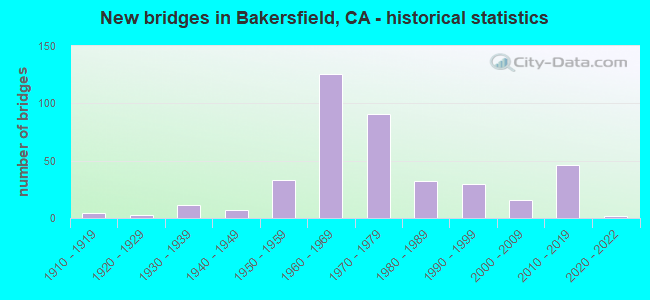
- New bridges - historical statistics
- 41910-1919
- 31920-1929
- 111930-1939
- 71940-1949
- 331950-1959
- 1261960-1969
- 911970-1979
- 321980-1989
- 301990-1999
- 162000-2009
- 462010-2019
- 22020-2022
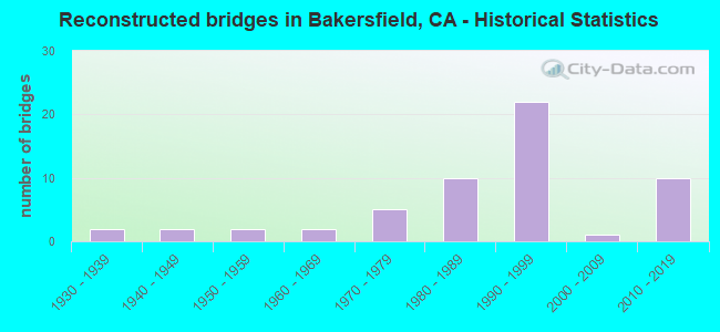
- Reconstructed bridges - Historical Statistics
- 21930-1939
- 21940-1949
- 21950-1959
- 21960-1969
- 51970-1979
- 101980-1989
- 221990-1999
- 12000-2009
- 102010-2019
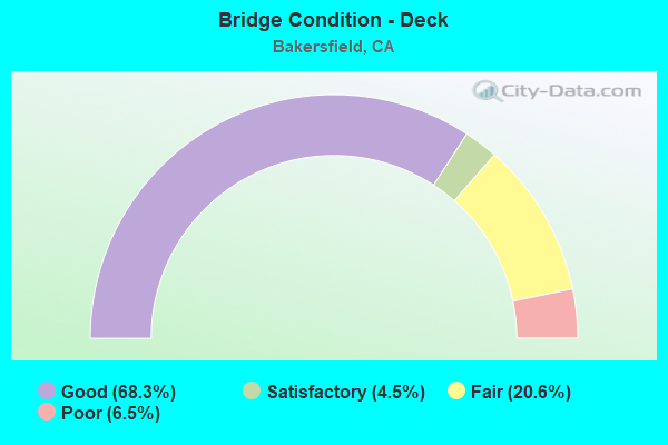
- Bridge Condition - Deck
- 68.3%Good
- 4.5%Satisfactory
- 20.6%Fair
- 6.5%Poor
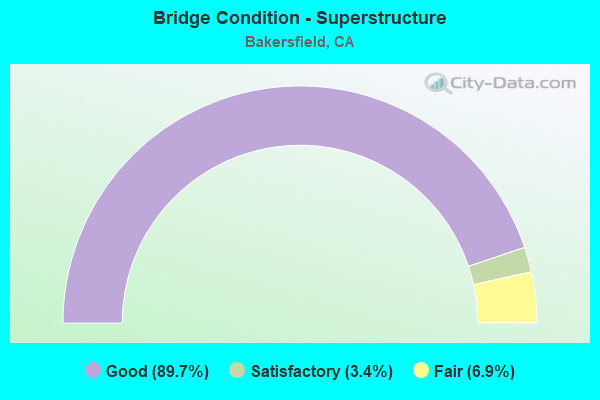
- Bridge Condition - Superstructure
- 89.7%Good
- 3.4%Satisfactory
- 6.9%Fair
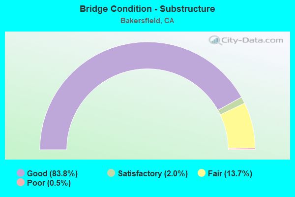
- Bridge Condition - Substructure
- 83.8%Good
- 2.0%Satisfactory
- 13.7%Fair
- 0.5%Poor
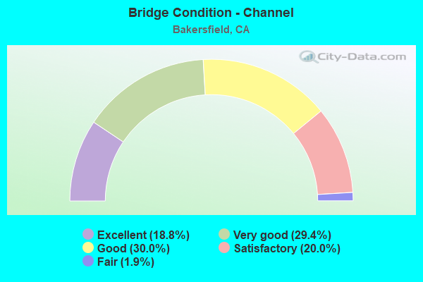
- Bridge Condition - Channel
- 18.8%Excellent
- 29.4%Very good
- 30.0%Good
- 20.0%Satisfactory
- 1.9%Fair
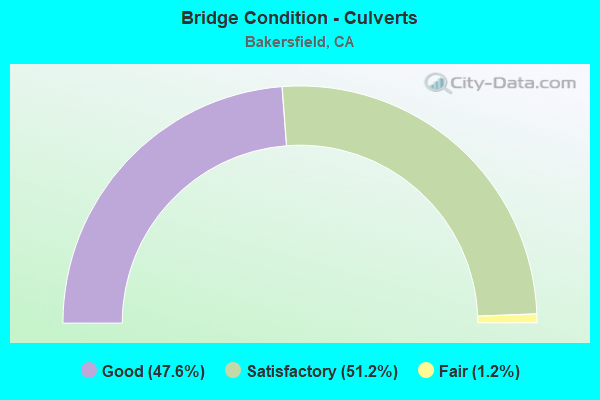
- Bridge Condition - Culverts
- 47.6%Good
- 51.2%Satisfactory
- 1.2%Fair
Find on map >> Show street view
Structure Number: 50C0394, Location: 0.5 MI EAST SR 99 (Lat: 35.380872, Lng: -119.036806), Route carried "on" structure: City street , Year Built: 1930, Year Reconstructed: 1981, Status: Open, Structure Length: 0.79m (2.59ft), Average Daily Traffic: 52,000 (year 2015), Truck Traffic: 9%, Average Future Daily Traffic: 57,193 (year 2042), Features Intersected: CARRIER CANAL, Facility Carried by Structure: 24TH ST (OLD 178)
Minimum Vertical Clearance: 30+ m (98+ ft), Kilometerpoint: 0.000, Lanes on structure: 4, Base Highway Network: Yes, Owner: City or Municipal Highway Agency, Approaching Roadway Width: 21.3m (69.9ft), Skew: 3 degrees, Material/Design: Concrete continuous, Design/Construction: Culvert, Number Of Spans In Main Unit: 2, Length of Maximum Span: 3.7m (12.1ft)
Condition: Channel: Good, Culverts: Good, Operating Rating: 27.2 metric tons, Method Used To Determine Operating Rating: Field evaluation and documented engineering judgment, Inventory Rating: 16.2 metric tons, Method Used To Determine Inventory Rating: Field evaluation and documented engineering judgment, Structural Evaluation: Meets minimum limits, Waterway Adequacy: Equal to present desirable criteria, Approach Roadway Alignment: Equal to present desirable criteria, Designated Inspection Frequency: Every 24 months, Underwater Inspection Frequency: Every 60 months, Inspection Date: December 2020, Underwater Inspection Date: Febuary 2021
Find on map >> Show street view
Structure Number: 50C0395, Location: COFFEE RD(2.7 MI W RTE99) (Lat: 35.383236, Lng: -119.091822), Route carried "on" structure: City street , Year Built: 1951, Year Reconstructed: 1998, Status: Open, Structure Length: 2.16m (7.09ft), Average Daily Traffic: 41,250 (year 2016), Truck Traffic: 17%, Average Future Daily Traffic: 66,722 (year 2042), Features Intersected: FRIANT-KERN CANAL, Facility Carried by Structure: ROSEDALE HWY
Minimum Vertical Clearance: 30+ m (98+ ft), Kilometerpoint: 0.000, Lanes on structure: 7, Base Highway Network: Yes, Owner: City or Municipal Highway Agency, Approaching Roadway Width: 45.2m (148.3ft), Skew: 20 degrees, Material/Design: Concrete, Design/Construction: Tee Beam, Number Of Spans In Main Unit: 2, Length of Maximum Span: 21.3m (69.9ft), Curb or Sidewalk Widths: Left: 1.5m (4.9ft), Right: 1.5m (4.9ft), Curb-To-Curb Width: 45.2m (148.3ft), Out-to-Out Width: 49.3m (161.7ft)
Condition: Deck: Good, Superstructure: Good, Substructure: Good, Channel: Very good, Operating Rating: 54.1 metric tons, Method Used To Determine Operating Rating: Field evaluation and documented engineering judgment, Inventory Rating: 32.4 metric tons, Method Used To Determine Inventory Rating: Field evaluation and documented engineering judgment, Structural Evaluation: Better than present minimum criteria, Deck Geometry: Superior to present desirable criteria, Waterway Adequacy: Equal to present desirable criteria, Approach Roadway Alignment: Equal to present desirable criteria, Designated Inspection Frequency: Every 24 months, Underwater Inspection Frequency: Every 60 months, Inspection Date: December 2020, Underwater Inspection Date: December 2021, Deck Structure Type: Concrete Cast-file-Place, Wearing Surface/Protective System: Wearing Surface: Bituminous
Find on map >> Show street view
Structure Number: 50C0396, Location: 0.2 MI EAST COFFEE RD (Lat: 35.383269, Lng: -119.088164), Route carried "on" structure: City street , Year Built: 1970, Status: Open, Structure Length: 3.47m (11.38ft), Average Daily Traffic: 41,250 (year 2014), Truck Traffic: 17%, Average Future Daily Traffic: 66,722 (year 2042), Design Load: HS 20, Features Intersected: CALLOWAY CANAL, Facility Carried by Structure: ROSEDALE HWY
Minimum Vertical Clearance: 30+ m (98+ ft), Kilometerpoint: 0.000, Lanes on structure: 5, Base Highway Network: Yes, Owner: City or Municipal Highway Agency, Approaching Roadway Width: 27.4m (89.9ft), Skew: 23 degrees, Material/Design: Concrete continuous, Design/Construction: Slab, Number Of Spans In Main Unit: 4, Length of Maximum Span: 8.5m (27.9ft), Curb or Sidewalk Widths: Left: 1.5m (4.9ft), Right: 0.0m, Curb-To-Curb Width: 21.3m (69.9ft), Out-to-Out Width: 29.6m (97.1ft)
Condition: Deck: Good, Superstructure: Good, Substructure: Fair, Channel: Very good, Operating Rating: 59.9 metric tons, Method Used To Determine Operating Rating: Load Factor (LF), Inventory Rating: 36.0 metric tons, Method Used To Determine Inventory Rating: Load Factor (LF), Structural Evaluation: Somewhat better than minimum adequacy, Deck Geometry: Somewhat better than minimum adequacy, Waterway Adequacy: Equal to present desirable criteria, Approach Roadway Alignment: Equal to present desirable criteria, Designated Inspection Frequency: Every 24 months, Inspection Date: December 2020, Deck Structure Type: Concrete Cast-file-Place, Wearing Surface/Protective System: Wearing Surface: Bituminous
Find on map >> Show street view
Structure Number: 50C0397, Location: 0.5 MI W OF MOHAWK ST. (Lat: 35.383228, Lng: -119.075567), Route carried "on" structure: County highway , Year Built: 1970, Status: Open, Structure Length: 4.97m (16.31ft), Average Daily Traffic: 41,250 (year 2009), Truck Traffic: 17%, Average Future Daily Traffic: 69,905 (year 2043), Design Load: HS 20, Features Intersected: CALLOWAY CANAL, Facility Carried by Structure: STATE ROUTE 58
Minimum Vertical Clearance: 30+ m (98+ ft), Kilometerpoint: 0.000, Lanes on structure: 5, Base Highway Network: Yes, Owner: County Highway Agency, Approaching Roadway Width: 27.4m (89.9ft), Skew: 25 degrees, Material/Design: Concrete continuous, Design/Construction: Slab, Number Of Spans In Main Unit: 5, Length of Maximum Span: 9.8m (32.2ft), Curb or Sidewalk Widths: Left: 1.5m (4.9ft), Right: 0.0m, Curb-To-Curb Width: 21.4m (70.2ft), Out-to-Out Width: 29.6m (97.1ft)
Condition: Deck: Fair, Superstructure: Fair, Substructure: Fair, Channel: Very good, Operating Rating: 63.8 metric tons, Method Used To Determine Operating Rating: Load Factor (LF), Inventory Rating: 38.2 metric tons, Method Used To Determine Inventory Rating: Load Factor (LF), Structural Evaluation: Somewhat better than minimum adequacy, Deck Geometry: Somewhat better than minimum adequacy, Waterway Adequacy: Equal to present desirable criteria, Approach Roadway Alignment: Equal to present desirable criteria, Designated Inspection Frequency: Every 24 months, Inspection Date: November 2021, Deck Structure Type: Concrete Cast-file-Place, Wearing Surface/Protective System: Wearing Surface: Bituminous
Find on map >> Show street view
Structure Number: 50C0399, Location: 0.6 MI N OF ROSEDALE HWY (Lat: 35.391889, Lng: -119.065778), Route carried "on" structure: Business City street , Year Built: 2014, Status: Open, Structure Length: 1.38m (4.53ft), Average Daily Traffic: 20,000 (year 2015), Truck Traffic: 5%, Average Future Daily Traffic: 14,000 (year 2038), Features Intersected: CALLOWAY CANAL, Facility Carried by Structure: MOHAWK STREET
Minimum Vertical Clearance: 30+ m (98+ ft), Kilometerpoint: 0.000, Lanes on structure: 4, Base Highway Network: Yes, Owner: City or Municipal Highway Agency, Approaching Roadway Width: 26.2m (86.0ft), Skew: 30 degrees, Material/Design: Concrete, Design/Construction: Arch - Deck, Number Of Spans In Main Unit: 1, Length of Maximum Span: 12.8m (42.0ft), Curb or Sidewalk Widths: Left: 1.5m (4.9ft), Right: 1.5m (4.9ft), Curb-To-Curb Width: 26.2m (86.0ft), Out-to-Out Width: 40.2m (131.9ft)
Condition: Superstructure: Good, Substructure: Good, Channel: Very good, Operating Rating: 54.1 metric tons, Method Used To Determine Operating Rating: Field evaluation and documented engineering judgment, Inventory Rating: 32.4 metric tons, Method Used To Determine Inventory Rating: Field evaluation and documented engineering judgment, Structural Evaluation: Better than present minimum criteria, Deck Geometry: Superior to present desirable criteria, Waterway Adequacy: Equal to present desirable criteria, Approach Roadway Alignment: Equal to present desirable criteria, Designated Inspection Frequency: Every 48 months, Inspection Date: October 2021
Find on map >> Show street view
Structure Number: 50C0401, Location: 1.0 MI E OF CAPITAL HILLS (Lat: 35.141511, Lng: -118.434422), Route carried "on" structure: City street , Year Built: 2014, Status: Open, Structure Length: 0.70m (2.30ft), Average Daily Traffic: 3,706 (year 2011), Truck Traffic: 10%, Average Future Daily Traffic: 6,543 (year 2041), Design Load: HS 20, Features Intersected: EAST DRAINAGE CHANNEL, Facility Carried by Structure: CHALLENGER DRIVE
Minimum Vertical Clearance: 30+ m (98+ ft), Kilometerpoint: 0.000, Lanes on structure: 2, Owner: City or Municipal Highway Agency, Approaching Roadway Width: 19.5m (64.0ft), Skew: 4 degrees, Material/Design: Concrete continuous, Design/Construction: Culvert, Number Of Spans In Main Unit: 2, Length of Maximum Span: 3.5m (11.5ft), Curb-To-Curb Width: 19.5m (64.0ft), Out-to-Out Width: 20.5m (67.3ft)
Condition: Channel: Very good, Culverts: Good, Operating Rating: 54.1 metric tons, Method Used To Determine Operating Rating: Field evaluation and documented engineering judgment, Inventory Rating: 32.4 metric tons, Method Used To Determine Inventory Rating: Field evaluation and documented engineering judgment, Structural Evaluation: Better than present minimum criteria, Deck Geometry: Superior to present desirable criteria, Waterway Adequacy: Better than present minimum criteria, Approach Roadway Alignment: Equal to present desirable criteria, Designated Inspection Frequency: Every 48 months, Inspection Date: November 2019, Deck Structure Type: Concrete Cast-file-Place
Find on map >> Show street view
Structure Number: 50C0402, Location: 0.2 MI W OF KERN RIVER BR (Lat: 35.371456, Lng: -119.062672), Route carried "on" structure: County highway , Year Built: 2012, Status: Open, Structure Length: 1.46m (4.79ft), Average Daily Traffic: 20,000 (year 2016), Truck Traffic: 3%, Average Future Daily Traffic: 26,000 (year 2038), Design Load: HS 20, Features Intersected: CROSS VALLY CANAL, Facility Carried by Structure: WESTSIDE PARKWAY
Minimum Vertical Clearance: 30+ m (98+ ft), Kilometerpoint: 0.000, Lanes on structure: 4, Base Highway Network: Yes, Owner: City or Municipal Highway Agency, Approaching Roadway Width: 25.0m (82.0ft), Skew: 9 degrees, Material/Design: Concrete continuous, Design/Construction: Culvert, Number Of Spans In Main Unit: 4, Length of Maximum Span: 3.6m (11.8ft)
Condition: Channel: Excellent, Culverts: Good, Operating Rating: 54.1 metric tons, Method Used To Determine Operating Rating: Field evaluation and documented engineering judgment, Inventory Rating: 32.4 metric tons, Method Used To Determine Inventory Rating: Field evaluation and documented engineering judgment, Structural Evaluation: Better than present minimum criteria, Waterway Adequacy: Equal to present desirable criteria, Approach Roadway Alignment: Equal to present desirable criteria, Designated Inspection Frequency: Every 48 months, Inspection Date: December 2021
Find on map >> Show street view
Structure Number: 50C0403, Location: 1000 FT W OF ALLEN RD (Lat: 35.360253, Lng: -119.147908), Route carried "on" structure: County highway , Year Built: 2013, Status: Open, Structure Length: 0.66m (2.17ft), Average Daily Traffic: 1,000 (year 2016), Truck Traffic: 3%, Average Future Daily Traffic: 3,000 (year 2038), Features Intersected: GOOSE LAKE SLOUGH, Facility Carried by Structure: WESTSIDE PARKWAY
Minimum Vertical Clearance: 30+ m (98+ ft), Kilometerpoint: 0.000, Lanes on structure: 4, Base Highway Network: Yes, Owner: City or Municipal Highway Agency, Approaching Roadway Width: 20.0m (65.6ft), Skew: 9 degrees, Material/Design: Concrete continuous, Design/Construction: Culvert, Number Of Spans In Main Unit: 2, Length of Maximum Span: 3.0m (9.8ft)
Condition: Channel: Excellent, Culverts: Good, Operating Rating: 54.1 metric tons, Method Used To Determine Operating Rating: Field evaluation and documented engineering judgment, Inventory Rating: 32.4 metric tons, Method Used To Determine Inventory Rating: Field evaluation and documented engineering judgment, Structural Evaluation: Better than present minimum criteria, Waterway Adequacy: Equal to present desirable criteria, Approach Roadway Alignment: Equal to present desirable criteria, Designated Inspection Frequency: Every 48 months, Inspection Date: October 2021
Find on map >> Show street view
Structure Number: 50C0404, Location: BAKERSFIELD (Lat: 35.360197, Lng: -119.145311), Route carried "on" structure: City street , Year Built: 2012, Status: Open, Structure Length: 0.61m (2.00ft), Average Daily Traffic: 1,000 (year 2016), Truck Traffic: 3%, Average Future Daily Traffic: 2,500 (year 2038), Features Intersected: GOOSE LAKE SLOUGH, Facility Carried by Structure: ALLEN ROAD
Minimum Vertical Clearance: 30+ m (98+ ft), Kilometerpoint: 0.000, Lanes on structure: 2, Owner: City or Municipal Highway Agency, Approaching Roadway Width: 18.0m (59.1ft), Skew: 9 degrees, Material/Design: Concrete continuous, Design/Construction: Culvert, Number Of Spans In Main Unit: 2, Length of Maximum Span: 3.0m (9.8ft)
Condition: Channel: Excellent, Culverts: Good, Operating Rating: 54.1 metric tons, Method Used To Determine Operating Rating: Field evaluation and documented engineering judgment, Inventory Rating: 32.4 metric tons, Method Used To Determine Inventory Rating: Field evaluation and documented engineering judgment, Structural Evaluation: Better than present minimum criteria, Waterway Adequacy: Equal to present desirable criteria, Approach Roadway Alignment: Equal to present desirable criteria, Designated Inspection Frequency: Every 48 months, Inspection Date: October 2021
Find on map >> Show street view
Structure Number: 50 0004, Location: 06-KER-204-3.34-BKD (Lat: 35.372261, Lng: -119.003089), Route carried "under" structure: State highway 204, Year Built: 1934, Structure Length: 0. m, Average Daily Traffic: 43,000 (year 2009), Truck Traffic: 12%, Features Intersected: ST RTE 204 (UNION AVE), Facility Carried by Structure: BNSF RY & AMTRAK
Minimum Vertical Clearance: 4.69m (15.39ft), Kilometerpoint: 3.340, Lanes under structure: 6, Material/Design: Steel, Design/Construction: Girder and Floorbeam System, Length of Maximum Span: 15.2m (49.9ft)
Find on map >> Show street view
Structure Number: 50 0185, Location: 06-KER-099-27.87 (Lat: 35.412214, Lng: -119.055319), Route carried "under" structure: State highway 99, Year Built: 1964, Structure Length: 0. m, Average Daily Traffic: 110,000 (year 2018), Truck Traffic: 28%, Features Intersected: STATE ROUTE 99 & OFFRAMP, Facility Carried by Structure: OLIVE DRIVE
Minimum Vertical Clearance: 4.54m (14.90ft), Kilometerpoint: 27.870, Lanes on structure: 4, Lanes under structure: 7, Material/Design: Steel, Design/Construction: Stringer/Multi-beam, Length of Maximum Span: 41.1m (134.8ft)
Find on map >> Show street view
Structure Number: 50 0205F, Location: 06-KER-065-R0.01 (Lat: 35.434328, Lng: -119.076003), Route carried "under" structure: State highway 99, Year Built: 1964, Structure Length: 0. m, Average Daily Traffic: 61,000 (year 2009), Truck Traffic: 30%, Features Intersected: STATE ROUTE 99
Minimum Vertical Clearance: 5.13m (16.83ft), Kilometerpoint: 29.880, Lanes on structure: 2, Lanes under structure: 6, Material/Design: Concrete continuous, Design/Construction: Box Beam or Girders - Multiple, Length of Maximum Span: 27.4m (89.9ft)
Find on map >> Show street view
Structure Number: 50 0238K, Location: 06-KER-099-10.93 (Lat: 35.172408, Lng: -119.004558), Route carried "under" structure: State highway 99, Year Built: 1962, Structure Length: 0. m, Average Daily Traffic: 47,000 (year 2019), Truck Traffic: 25%, Features Intersected: STATE ROUTE 99
Minimum Vertical Clearance: 4.72m (15.49ft), Kilometerpoint: 10.930, Lanes on structure: 2, Lanes under structure: 6, Material/Design: Concrete continuous, Design/Construction: Box Beam or Girders - Multiple, Length of Maximum Span: 33.8m (110.9ft)
Find on map >> Show street view
Structure Number: 50 0241, Location: 06-KER-099-20.56 (Lat: 35.310119, Lng: -119.034297), Route carried "under" structure: County highway F243, Year Built: 1962, Structure Length: 0. m, Average Daily Traffic: 13,699 (year 2015), Truck Traffic: 2%, Features Intersected: PACHECO ROAD, Facility Carried by Structure: STATE ROUTE 99
Minimum Vertical Clearance: 4.95m (16.24ft), Kilometerpoint: 0.000, Lanes on structure: 8, Lanes under structure: 2, Material/Design: Concrete continuous, Design/Construction: Tee Beam, Length of Maximum Span: 22.9m (75.1ft)
Find on map >> Show street view
Structure Number: 50 0243, Location: 06-KER-223-R10.51 (Lat: 35.208481, Lng: -119.010819), Route carried "under" structure: State highway 99, Year Built: 1962, Structure Length: 0. m, Average Daily Traffic: 47,000 (year 2009), Truck Traffic: 25%, Features Intersected: STATE ROUTE 99, Facility Carried by Structure: STATE ROUTE 223
Minimum Vertical Clearance: 4.62m (15.16ft), Kilometerpoint: 13.410, Lanes on structure: 2, Lanes under structure: 8, Material/Design: Concrete continuous, Design/Construction: Box Beam or Girders - Multiple, Length of Maximum Span: 29.0m (95.1ft)
Find on map >> Show street view
Structure Number: 50 0245E, Location: 06-KER-119-31.26 (Lat: 35.266800, Lng: -119.023367), Route carried "under" structure: State highway 99, Year Built: 1962, Structure Length: 0. m, Average Daily Traffic: 66,500 (year 2009), Truck Traffic: 24%, Features Intersected: STATE ROUTE 99, Facility Carried by Structure: SR 119 (TAFT HWY)
Minimum Vertical Clearance: 5.20m (17.06ft), Kilometerpoint: 17.500, Lanes on structure: 2, Lanes under structure: 6, Material/Design: Concrete continuous, Design/Construction: Box Beam or Girders - Multiple, Length of Maximum Span: 29.3m (96.1ft)
Find on map >> Show street view
Structure Number: 50 0247, Location: 06-KER-099-19.54 (Lat: 35.295753, Lng: -119.030911), Route carried "under" structure: State highway 99, Year Built: 1962, Structure Length: 0. m, Average Daily Traffic: 66,500 (year 2009), Truck Traffic: 24%, Features Intersected: STATE ROUTE 99, Facility Carried by Structure: PANAMA LANE
Minimum Vertical Clearance: 4.62m (15.16ft), Kilometerpoint: 19.540, Lanes on structure: 6, Lanes under structure: 8, Material/Design: Concrete continuous, Design/Construction: Box Beam or Girders - Multiple, Length of Maximum Span: 29.3m (96.1ft)
Find on map >> Show street view
Structure Number: 50 0248, Location: 06-KER-099-21.08-BKD (Lat: 35.317511, Lng: -119.036619), Route carried "under" structure: State highway 99, Year Built: 1962, Structure Length: 0. m, Average Daily Traffic: 110,000 (year 2018), Features Intersected: STATE ROUTE 99, Facility Carried by Structure: WHITE LANE
Minimum Vertical Clearance: 4.52m (14.83ft), Kilometerpoint: 21.080, Lanes on structure: 7, Lanes under structure: 10, Material/Design: Concrete continuous, Design/Construction: Box Beam or Girders - Multiple, Length of Maximum Span: 29.3m (96.1ft)
Find on map >> Show street view
Structure Number: 50 0249, Location: 06-KER-099-21.96-BKD (Lat: 35.329453, Lng: -119.039658), Route carried "under" structure: State highway 99, Year Built: 1962, Structure Length: 0. m, Average Daily Traffic: 114,000 (year 2018), Truck Traffic: 10%, Features Intersected: STATE ROUTE 99, Facility Carried by Structure: WIBLE ROAD
Minimum Vertical Clearance: 4.62m (15.16ft), Kilometerpoint: 21.960, Lanes on structure: 4, Lanes under structure: 8, Material/Design: Concrete continuous, Design/Construction: Box Beam or Girders - Multiple, Length of Maximum Span: 46.0m (150.9ft)
Find on map >> Show street view
Structure Number: 50 025, Location: 06-KER-099-22.11-BKD (Lat: 35.332122, Lng: -119.039978), Route carried "under" structure: State highway 99, Year Built: 1962, Structure Length: 0. m, Average Daily Traffic: 114,000 (year 2018), Truck Traffic: 10%, Features Intersected: STATE ROUTE 99, Facility Carried by Structure: WILSON ROAD
Minimum Vertical Clearance: 4.72m (15.49ft), Kilometerpoint: 22.110, Lanes on structure: 5, Lanes under structure: 6, Material/Design: Concrete continuous, Design/Construction: Tee Beam, Length of Maximum Span: 21.6m (70.9ft)
Find on map >> Show street view
Structure Number: 50 0252, Location: 06-KER-099-21.60-BKD (Lat: 35.324856, Lng: -119.038439), Route carried "under" structure: State highway 99, Year Built: 1962, Structure Length: 0. m, Average Daily Traffic: 114,000 (year 2018), Truck Traffic: 10%, Features Intersected: STATE ROUTE 99, Facility Carried by Structure: PLANZ ROAD
Minimum Vertical Clearance: 4.67m (15.32ft), Kilometerpoint: 21.600, Lanes on structure: 5, Lanes under structure: 8, Material/Design: Concrete continuous, Design/Construction: Tee Beam, Length of Maximum Span: 21.9m (71.9ft)
Find on map >> Show street view
Structure Number: 50 0254F, Location: 06-KER-099-27.05 (Lat: 35.403222, Lng: -119.045942), Route carried "under" structure: State highway 99, Year Built: 1963, Structure Length: 0. m, Average Daily Traffic: 114,000 (year 2018), Truck Traffic: 28%, Features Intersected: STATE ROUTE 99
Minimum Vertical Clearance: 4.67m (15.32ft), Kilometerpoint: 27.050, Lanes on structure: 2, Lanes under structure: 6, Material/Design: Concrete continuous, Design/Construction: Box Beam or Girders - Multiple, Length of Maximum Span: 34.4m (112.9ft)
Find on map >> Show street view
Structure Number: 50 0255, Location: 06-KER-204-3.41-BKD (Lat: 35.373200, Lng: -119.003219), Route carried "under" structure: State highway 204, Year Built: 1959, Structure Length: 0. m, Average Daily Traffic: 43,000 (year 2009), Truck Traffic: 12%, Features Intersected: ST RTE 204 (UNION AVE), Facility Carried by Structure: TRUXTUN AVENUE
Minimum Vertical Clearance: 4.65m (15.26ft), Kilometerpoint: 3.410, Lanes on structure: 4, Lanes under structure: 8, Material/Design: Steel, Design/Construction: Stringer/Multi-beam, Length of Maximum Span: 26.9m (88.3ft)
Find on map >> Show street view
Structure Number: 50 0256, Location: 06-KER-099-22.60-BKD (Lat: 35.339303, Lng: -119.040011), Route carried "under" structure: State highway 99, Year Built: 1962, Structure Length: 0. m, Average Daily Traffic: 120,000 (year 2018), Truck Traffic: 10%, Features Intersected: STATE ROUTE 99, Facility Carried by Structure: MING AVENUE
Minimum Vertical Clearance: 4.62m (15.16ft), Kilometerpoint: 22.600, Lanes on structure: 7, Lanes under structure: 10, Material/Design: Concrete continuous, Design/Construction: Box Beam or Girders - Multiple, Length of Maximum Span: 31.7m (104.0ft)
Find on map >> Show street view
Structure Number: 50 0257, Location: 06-KER-099-22.65-BKD (Lat: 35.340367, Lng: -119.038822), Route carried "under" structure: Ramp State highway 99, Year Built: 1962, Structure Length: 0. m, Average Daily Traffic: 7,600 (year 2012), Truck Traffic: 23%, Features Intersected: N99-MING AVE OFF RAMP, Facility Carried by Structure: WIBLE ROAD
Minimum Vertical Clearance: 4.67m (15.32ft), Kilometerpoint: 22.650, Lanes on structure: 4, Lanes under structure: 1, Material/Design: Concrete, Design/Construction: Slab, Length of Maximum Span: 15.2m (49.9ft)
Find on map >> Show street view
Structure Number: 50 0258, Location: 06-KER-099-22.70-BKD (Lat: 35.341000, Lng: -119.038842), Route carried "under" structure: Ramp State highway 99, Year Built: 1962, Structure Length: 0. m, Average Daily Traffic: 18,400 (year 2012), Truck Traffic: 23%, Features Intersected: MING AVE-N99 ON RAMP, Facility Carried by Structure: WIBLE ROAD
Minimum Vertical Clearance: 4.67m (15.32ft), Kilometerpoint: 22.700, Lanes on structure: 4, Lanes under structure: 1, Material/Design: Concrete, Design/Construction: Slab, Length of Maximum Span: 13.4m (44.0ft)
Find on map >> Show street view
Structure Number: 50 026, Location: 06-KER-099-24.60-BKD (Lat: 35.368192, Lng: -119.041414), Route carried "under" structure: City street F251, Year Built: 1963, Structure Length: 0. m, Average Daily Traffic: 33,859 (year 2013), Truck Traffic: 10%, Features Intersected: CALIFORNIA AVENUE, Facility Carried by Structure: STATE ROUTE 99
Minimum Vertical Clearance: 4.49m (14.73ft), Kilometerpoint: 0.000, Lanes on structure: 10, Lanes under structure: 6, Material/Design: Concrete continuous, Design/Construction: Tee Beam, Length of Maximum Span: 22.6m (74.1ft)
Find on map >> Show street view
Structure Number: 50 0261, Location: 06-KER-099-24.11-BKD (Lat: 35.361253, Lng: -119.039853), Route carried "under" structure: State highway 99, Year Built: 1963, Structure Length: 0. m, Average Daily Traffic: 134,000 (year 2018), Truck Traffic: 23%, Features Intersected: STATE ROUTE 99, Facility Carried by Structure: PALM AVENUE
Minimum Vertical Clearance: 4.90m (16.08ft), Kilometerpoint: 24.110, Lanes on structure: 2, Lanes under structure: 8, Material/Design: Concrete continuous, Design/Construction: Tee Beam, Length of Maximum Span: 21.6m (70.9ft)
Find on map >> Show street view
Structure Number: 50 0264, Location: 06-KER-099-23.62-BKD (Lat: 35.354011, Lng: -119.039786), Route carried "under" structure: State highway 99, Year Built: 1963, Structure Length: 0. m, Average Daily Traffic: 134,000 (year 2018), Truck Traffic: 23%, Features Intersected: STATE ROUTE 99, Facility Carried by Structure: BRUNDAGE LANE
Minimum Vertical Clearance: 4.59m (15.06ft), Kilometerpoint: 23.620, Lanes on structure: 7, Lanes under structure: 8, Material/Design: Concrete continuous, Design/Construction: Box Beam or Girders - Multiple, Length of Maximum Span: 24.5m (80.4ft)
Find on map >> Show street view
Structure Number: 50 0266, Location: 06-KER-099-26.78 (Lat: 35.398364, Lng: -119.045372), Route carried "under" structure: State highway 99, Year Built: 1963, Structure Length: 0. m, Average Daily Traffic: 100,000 (year 2009), Truck Traffic: 28%, Features Intersected: SR 99,BUCK OWENS,CALLOWY
Minimum Vertical Clearance: 4.64m (15.22ft), Kilometerpoint: 26.780, Lanes on structure: 2, Lanes under structure: 10, Material/Design: Concrete continuous, Design/Construction: Box Beam or Girders - Multiple, Length of Maximum Span: 36.0m (118.1ft)
Find on map >> Show street view
Structure Number: 50 0267, Location: 06-KER-099-25.63-BKD (Lat: 35.382736, Lng: -119.044208), Route carried "under" structure: State highway 178, Year Built: 1963, Structure Length: 0. m, Average Daily Traffic: 5,200 (year 2018), Features Intersected: SR 178 (ROSEDALE HWY), Facility Carried by Structure: STATE ROUTE 99
Minimum Vertical Clearance: 4.85m (15.91ft), Kilometerpoint: 51.810, Lanes on structure: 10, Lanes under structure: 5, Material/Design: Prestressed concrete continuous, Design/Construction: Stringer/Multi-beam, Length of Maximum Span: 21.5m (70.5ft)
Find on map >> Show street view
Structure Number: 50 0268, Location: 06-KER-099-24.99-BKD (Lat: 35.373469, Lng: -119.043739), Route carried "under" structure: City street F252, Year Built: 1963, Structure Length: 0. m, Average Daily Traffic: 48,302 (year 2018), Truck Traffic: 3%, Features Intersected: TRUXTUN AVE, Facility Carried by Structure: STATE ROUTE 99
Minimum Vertical Clearance: 4.44m (14.57ft), Kilometerpoint: 0.000, Lanes on structure: 8, Lanes under structure: 4, Material/Design: Concrete continuous, Design/Construction: Tee Beam, Length of Maximum Span: 20.7m (67.9ft)
Find on map >> Show street view
Structure Number: 50 0277L, Location: 06-KER-099-R30.54 (Lat: 35.441400, Lng: -119.084769), Route carried "under" structure: State highway 99, Year Built: 2010, Structure Length: 0. m, Average Daily Traffic: 63,000 (year 2009), Truck Traffic: 30%, Features Intersected: STATE ROUTE 99, Facility Carried by Structure: 7TH STANDARD RD WB
Minimum Vertical Clearance: 5.08m (16.67ft), Kilometerpoint: 30.540, Lanes on structure: 3, Lanes under structure: 6, Material/Design: Prestressed concrete continuous, Design/Construction: Box Beam or Girders - Multiple, Length of Maximum Span: 38.0m (124.7ft)
Find on map >> Show street view
Structure Number: 50 0277R, Location: 06-KER-099-R30.53 (Lat: 35.441272, Lng: -119.084531), Route carried "under" structure: State highway 99, Year Built: 1964, Structure Length: 0. m, Average Daily Traffic: 61,000 (year 2009), Truck Traffic: 30%, Features Intersected: STATE ROUTE 99, Facility Carried by Structure: 7TH STANDARD RD EB
Minimum Vertical Clearance: 4.69m (15.39ft), Kilometerpoint: 30.530, Lanes on structure: 2, Lanes under structure: 6, Material/Design: Concrete continuous, Design/Construction: Box Beam or Girders - Multiple, Length of Maximum Span: 36.9m (121.1ft)
Find on map >> Show street view
Structure Number: 50 0283, Location: 06-KER-178-R3.33-BKD (Lat: 35.385853, Lng: -118.988283), Route carried "under" structure: State highway 178, Year Built: 1967, Structure Length: 0. m, Average Daily Traffic: 51,000 (year 2009), Truck Traffic: 6%, Features Intersected: STATE ROUTE 178, Facility Carried by Structure: FLOWER ST
Minimum Vertical Clearance: 4.87m (15.98ft), Kilometerpoint: 3.330, Lanes on structure: 2, Lanes under structure: 7, Material/Design: Concrete continuous, Design/Construction: Box Beam or Girders - Multiple, Length of Maximum Span: 47.5m (155.8ft)
Find on map >> Show street view
Structure Number: 50 0284, Location: 06-KER-178-R3.38-BKD (Lat: 35.386375, Lng: -118.986258), Route carried "under" structure: State highway 178, Year Built: 1967, Structure Length: 0. m, Average Daily Traffic: 51,000 (year 2009), Truck Traffic: 6%, Features Intersected: STATE ROUTE 178, Facility Carried by Structure: BEALE AVE
Minimum Vertical Clearance: 4.72m (15.49ft), Kilometerpoint: 3.380, Lanes on structure: 5, Lanes under structure: 7, Material/Design: Concrete continuous, Design/Construction: Box Beam or Girders - Multiple, Length of Maximum Span: 29.9m (98.1ft)
Find on map >> Show street view
Structure Number: 50 0285, Location: 06-KER-178-R3.16-BKD (Lat: 35.385461, Lng: -118.989922), Route carried "under" structure: State highway 178, Year Built: 1967, Structure Length: 0. m, Average Daily Traffic: 51,000 (year 2009), Truck Traffic: 6%, Features Intersected: STATE ROUTE 178, Facility Carried by Structure: BAKER ST
Minimum Vertical Clearance: 4.85m (15.91ft), Kilometerpoint: 3.160, Lanes on structure: 3, Lanes under structure: 7, Material/Design: Concrete continuous, Design/Construction: Box Beam or Girders - Multiple, Length of Maximum Span: 30.5m (100.1ft)
Find on map >> Show street view
Structure Number: 50 0289L, Location: 06-KER-178-R2.41-BKD (Lat: 35.383603, Lng: -119.003072), Route carried "under" structure: City street F297, Year Built: 1967, Structure Length: 0. m, Average Daily Traffic: 25,271 (year 2012), Truck Traffic: 1%, Features Intersected: UNION AVE, Facility Carried by Structure: SR 178 WB
Minimum Vertical Clearance: 4.75m (15.58ft), Kilometerpoint: 0.000, Lanes on structure: 3, Lanes under structure: 9, Material/Design: Prestressed concrete continuous, Design/Construction: Stringer/Multi-beam, Length of Maximum Span: 18.6m (61.0ft)
Find on map >> Show street view
Structure Number: 50 0289R, Location: 06-KER-178-R2.41-BKD (Lat: 35.383358, Lng: -119.003061), Route carried "under" structure: City street F297, Year Built: 1967, Structure Length: 0. m, Average Daily Traffic: 25,271 (year 2012), Truck Traffic: 1%, Features Intersected: UNION AVE, Facility Carried by Structure: SR 178 EB
Minimum Vertical Clearance: 4.95m (16.24ft), Kilometerpoint: 0.000, Lanes on structure: 3, Lanes under structure: 9, Material/Design: Prestressed concrete continuous, Design/Construction: Stringer/Multi-beam, Length of Maximum Span: 18.6m (61.0ft)
Find on map >> Show street view
Structure Number: 50 03, Location: 06-KER-119-19.74 (Lat: 35.267061, Lng: -119.225075), Route carried "under" structure: Interstate 5, Year Built: 1967, Structure Length: 0. m, Average Daily Traffic: 30,000 (year 2009), Truck Traffic: 24%, Features Intersected: INTERSTATE 5, Facility Carried by Structure: STATE ROUTE 119
Minimum Vertical Clearance: 5.13m (16.83ft), Kilometerpoint: 38.790, Lanes on structure: 2, Lanes under structure: 4, Material/Design: Prestressed concrete continuous, Design/Construction: Box Beam or Girders - Multiple, Length of Maximum Span: 46.3m (151.9ft)
Find on map >> Show street view
Structure Number: 50 0301, Location: 06-KER-043-1.86 (Lat: 35.292861, Lng: -119.252406), Route carried "under" structure: Interstate 5, Year Built: 1969, Structure Length: 0. m, Average Daily Traffic: 30,000 (year 2009), Truck Traffic: 24%, Features Intersected: INTERSTATE 5, Facility Carried by Structure: ST RT 43 (ENOS LN)
Minimum Vertical Clearance: 5.51m (18.08ft), Kilometerpoint: 41.190, Lanes on structure: 2, Lanes under structure: 4, Material/Design: Steel, Design/Construction: Stringer/Multi-beam, Length of Maximum Span: 44.5m (146.0ft)
Find on map >> Show street view
Structure Number: 50 0303, Location: 06-KER-005-42.97 (Lat: 35.311256, Lng: -119.275203), Route carried "under" structure: Interstate 5, Year Built: 1969, Structure Length: 0. m, Average Daily Traffic: 27,000 (year 2009), Truck Traffic: 22%, Features Intersected: INTERSTATE 5, Facility Carried by Structure: UTILITY SERVICE RD
Minimum Vertical Clearance: 5.18m (16.99ft), Kilometerpoint: 42.970, Lanes on structure: 2, Lanes under structure: 4, Material/Design: Prestressed concrete continuous, Design/Construction: Box Beam or Girders - Multiple, Length of Maximum Span: 37.5m (123.0ft)
Find on map >> Show street view
Structure Number: 50 0304, Location: 06-KER-005-45.13 (Lat: 35.331778, Lng: -119.303900), Route carried "under" structure: Interstate 5, Year Built: 1969, Structure Length: 0. m, Average Daily Traffic: 27,000 (year 2009), Truck Traffic: 22%, Features Intersected: INTERSTATE 5, Facility Carried by Structure: DWR SERVICE ROAD
Minimum Vertical Clearance: 5.11m (16.77ft), Kilometerpoint: 45.130, Lanes on structure: 2, Lanes under structure: 4, Material/Design: Concrete continuous, Design/Construction: Box Beam or Girders - Multiple, Length of Maximum Span: 33.8m (110.9ft)
Find on map >> Show street view
Structure Number: 50 0326L, Location: 06-KER-178-R1.95-BKD (Lat: 35.381781, Lng: -119.010697), Route carried "under" structure: State highway 204, Year Built: 1967, Structure Length: 0. m, Average Daily Traffic: 34,000 (year 2009), Truck Traffic: 9%, Features Intersected: ST RTE 204 & Q STREET, Facility Carried by Structure: STATE ROUTE 178 WB
Minimum Vertical Clearance: 7.92m (25.98ft), Kilometerpoint: 4.240, Lanes on structure: 4, Lanes under structure: 6, Material/Design: Prestressed concrete continuous, Design/Construction: Stringer/Multi-beam, Length of Maximum Span: 30.2m (99.1ft)
Find on map >> Show street view
Structure Number: 50 0326R, Location: 06-KER-178-R1.95-BKD (Lat: 35.381464, Lng: -119.010742), Route carried "under" structure: State highway 204, Year Built: 1967, Structure Length: 0. m, Average Daily Traffic: 43,000 (year 2009), Truck Traffic: 12%, Features Intersected: ST RTE 204 & Q STREET, Facility Carried by Structure: STATE ROUTE 178 EB
Minimum Vertical Clearance: 8.18m (26.84ft), Kilometerpoint: 4.230, Lanes on structure: 3, Lanes under structure: 6, Material/Design: Prestressed concrete continuous, Design/Construction: Box Beam or Girders - Multiple, Length of Maximum Span: 30.2m (99.1ft)
Find on map >> Show street view
Structure Number: 50 0326S, Location: 06-KER-178-R1.95-BKD (Lat: 35.381322, Lng: -119.010847), Route carried "under" structure: Ramp State highway 204, Year Built: 1967, Structure Length: 0. m, Average Daily Traffic: 43,000 (year 2009), Truck Traffic: 12%, Features Intersected: SR 204 & Q STREET, Facility Carried by Structure: SR 178 EB RAMP
Minimum Vertical Clearance: 7.95m (26.08ft), Kilometerpoint: 4.230, Lanes on structure: 1, Lanes under structure: 6, Material/Design: Prestressed concrete continuous, Design/Construction: Box Beam or Girders - Multiple, Length of Maximum Span: 30.2m (99.1ft)
Find on map >> Show street view
Structure Number: 50 0327, Location: 06-KER-178-R1.90-BKD (Lat: 35.381253, Lng: -119.011794), Route carried "under" structure: Ramp State highway 178, Year Built: 1967, Structure Length: 0. m, Average Daily Traffic: 25,900 (year 2010), Truck Traffic: 4%, Features Intersected: SR 178 SPUR WB\24TH ST
Minimum Vertical Clearance: 4.80m (15.75ft), Kilometerpoint: 1.900, Lanes on structure: 6, Lanes under structure: 3, Material/Design: Concrete continuous, Design/Construction: Box Beam or Girders - Multiple, Length of Maximum Span: 15.8m (51.8ft)
Find on map >> Show street view
Structure Number: 50 0327S, Location: 06-KER-178-R1.90-BKD (Lat: 35.381022, Lng: -119.011419), Route carried "under" structure: Spur State highway 178, Year Built: 1967, Structure Length: 0. m, Average Daily Traffic: 8,500 (year 2010), Truck Traffic: 2%, Features Intersected: 24TH STREET
Minimum Vertical Clearance: 7.95m (26.08ft), Kilometerpoint: 1.900, Lanes on structure: 2, Lanes under structure: 3, Material/Design: Concrete continuous, Design/Construction: Box Beam or Girders - Multiple, Length of Maximum Span: 15.2m (49.9ft)
Find on map >> Show street view
Structure Number: 50 0328, Location: 06-KER-178-R3.80-BKD (Lat: 35.389917, Lng: -118.981383), Route carried "under" structure: State highway 178, Year Built: 1967, Structure Length: 0. m, Average Daily Traffic: 51,000 (year 2009), Truck Traffic: 6%, Features Intersected: STATE ROUTE 178, Facility Carried by Structure: BERNARD ST
Minimum Vertical Clearance: 4.55m (14.93ft), Kilometerpoint: 3.800, Lanes on structure: 4, Lanes under structure: 6, Material/Design: Concrete continuous, Design/Construction: Box Beam or Girders - Multiple, Length of Maximum Span: 25.6m (84.0ft)
Find on map >> Show street view
Structure Number: 50 0329, Location: 06-KER-178-R4.09-BKD (Lat: 35.392469, Lng: -118.976422), Route carried "under" structure: State highway 178, Year Built: 1967, Structure Length: 0. m, Average Daily Traffic: 51,000 (year 2009), Truck Traffic: 6%, Features Intersected: STATE ROUTE 178, Facility Carried by Structure: HALEY ST
Minimum Vertical Clearance: 4.67m (15.32ft), Kilometerpoint: 4.090, Lanes on structure: 4, Lanes under structure: 7, Material/Design: Concrete continuous, Design/Construction: Box Beam or Girders - Multiple, Length of Maximum Span: 29.3m (96.1ft)
Find on map >> Show street view
Structure Number: 50 033, Location: 06-KER-178-R2.74-BKD (Lat: 35.383764, Lng: -118.997242), Route carried "under" structure: State highway 178, Year Built: 1967, Structure Length: 0. m, Average Daily Traffic: 51,000 (year 2009), Truck Traffic: 6%, Features Intersected: ST RTE 178, Facility Carried by Structure: ALTA VISTA DR
Minimum Vertical Clearance: 4.62m (15.16ft), Kilometerpoint: 2.740, Lanes on structure: 4, Lanes under structure: 6, Material/Design: Concrete continuous, Design/Construction: Box Beam or Girders - Multiple, Length of Maximum Span: 25.3m (83.0ft)
Find on map >> Show street view
Structure Number: 50 0331, Location: 06-KER-178-R2.81-BKD (Lat: 35.383797, Lng: -118.996603), Route carried "under" structure: State highway 178, Year Built: 1967, Structure Length: 0. m, Average Daily Traffic: 51,000 (year 2009), Truck Traffic: 6%, Features Intersected: STATE ROUTE 178, Facility Carried by Structure: NILES ST
Minimum Vertical Clearance: 6.01m (19.72ft), Kilometerpoint: 2.810, Lanes on structure: 3, Lanes under structure: 6, Material/Design: Concrete continuous, Design/Construction: Box Beam or Girders - Multiple, Length of Maximum Span: 27.7m (90.9ft)
Find on map >> Show street view
Structure Number: 50 0332F, Location: 06-KER-178-R1.97-BKD (Lat: 35.382767, Lng: -119.010831), Route carried "under" structure: City street F296, Year Built: 1967, Structure Length: 0. m, Average Daily Traffic: 7,581 (year 2013), Truck Traffic: 9%, Features Intersected: Q STREET, Facility Carried by Structure: W178-N204 CONNECTR
Minimum Vertical Clearance: 4.80m (15.75ft), Kilometerpoint: 0.000, Lanes on structure: 2, Lanes under structure: 4, Material/Design: Concrete continuous, Design/Construction: Box Beam or Girders - Multiple, Length of Maximum Span: 25.3m (83.0ft)
Find on map >> Show street view
Structure Number: 50 0333, Location: 06-KER-178-R4.59-BKD (Lat: 35.394778, Lng: -118.967678), Route carried "under" structure: State highway 178, Year Built: 1970, Structure Length: 0. m, Average Daily Traffic: 60,000 (year 2009), Truck Traffic: 6%, Features Intersected: STATE ROUTE 178, Facility Carried by Structure: MT VERNON AVE
Minimum Vertical Clearance: 4.57m (14.99ft), Kilometerpoint: 4.590, Lanes on structure: 5, Lanes under structure: 6, Material/Design: Concrete continuous, Design/Construction: Box Beam or Girders - Multiple, Length of Maximum Span: 30.5m (100.1ft)
Find on map >> Show street view
Structure Number: 50 0348, Location: 06-KER-099-9.30 (Lat: 35.150133, Lng: -118.997453), Route carried "under" structure: State highway 99, Year Built: 1967, Structure Length: 0. m, Average Daily Traffic: 45,250 (year 2009), Truck Traffic: 25%, Features Intersected: STATE ROUTE 99, Facility Carried by Structure: HERRING RD
Minimum Vertical Clearance: 4.69m (15.39ft), Kilometerpoint: 9.300, Lanes on structure: 2, Lanes under structure: 6, Material/Design: Prestressed concrete continuous, Design/Construction: Stringer/Multi-beam, Length of Maximum Span: 39.3m (128.9ft)
Find on map >> Show street view
Structure Number: 50 0349, Location: 06-KER-058-R53.52-BKD (Lat: 35.352847, Lng: -119.019094), Route carried "under" structure: State highway 58, Year Built: 1976, Structure Length: 0. m, Average Daily Traffic: 40,500 (year 2016), Truck Traffic: 29%, Features Intersected: ROUTE 58, Facility Carried by Structure: S CHESTER AVE OC
Minimum Vertical Clearance: 5.05m (16.57ft), Kilometerpoint: 53.520, Lanes on structure: 4, Lanes under structure: 6, Material/Design: Prestressed concrete continuous, Design/Construction: Box Beam or Girders - Multiple, Length of Maximum Span: 33.7m (110.6ft)
Find on map >> Show street view
Structure Number: 50 0359L, Location: 06-KER-058-R59.43 (Lat: 35.352381, Lng: -118.914461), Route carried "under" structure: State highway 184, Year Built: 1974, Structure Length: 0. m, Average Daily Traffic: 14,700 (year 2009), Truck Traffic: 5%, Features Intersected: SR 184 (WEEDPATCH HWY), Facility Carried by Structure: STATE ROUTE 58 WB
Minimum Vertical Clearance: 4.98m (16.34ft), Kilometerpoint: 7.940, Lanes on structure: 4, Lanes under structure: 4, Material/Design: Prestressed concrete, Design/Construction: Box Beam or Girders - Multiple, Length of Maximum Span: 40.0m (131.2ft)
Find on map >> Show street view
Structure Number: 50 0359R, Location: 06-KER-058-R59.43 (Lat: 35.352031, Lng: -118.914433), Route carried "under" structure: State highway 184, Year Built: 1970, Structure Length: 0. m, Average Daily Traffic: 21,100 (year 2019), Truck Traffic: 5%, Features Intersected: SR 184 (WEEDPATCH HWY), Facility Carried by Structure: STATE ROUTE 58 EB
Minimum Vertical Clearance: 4.57m (14.99ft), Kilometerpoint: 7.930, Lanes on structure: 4, Lanes under structure: 4, Material/Design: Prestressed concrete, Design/Construction: Box Beam or Girders - Multiple, Length of Maximum Span: 40.5m (132.9ft)
Find on map >> Show street view
Structure Number: 50 036, Location: 06-KER-058-R60.45 (Lat: 35.350878, Lng: -118.896525), Route carried "under" structure: State highway 58, Year Built: 1970, Structure Length: 0. m, Average Daily Traffic: 32,500 (year 2019), Truck Traffic: 23%, Features Intersected: SR 58, Facility Carried by Structure: VINELAND ROAD
Minimum Vertical Clearance: 5.08m (16.67ft), Kilometerpoint: 60.450, Lanes on structure: 2, Lanes under structure: 4, Material/Design: Concrete continuous, Design/Construction: Box Beam or Girders - Multiple, Length of Maximum Span: 31.1m (102.0ft)
Find on map >> Show street view
Structure Number: 50 0361, Location: 06-KER-058-R61.51 (Lat: 35.345892, Lng: -118.878719), Route carried "under" structure: State highway 58, Year Built: 1970, Structure Length: 0. m, Average Daily Traffic: 23,000 (year 2009), Features Intersected: SR 58, Facility Carried by Structure: EDISON ROAD
Minimum Vertical Clearance: 5.03m (16.50ft), Kilometerpoint: 61.510, Lanes on structure: 2, Lanes under structure: 4, Material/Design: Concrete continuous, Design/Construction: Box Beam or Girders - Multiple, Length of Maximum Span: 33.8m (110.9ft)
Find on map >> Show street view
Structure Number: 50 0362, Location: 06-KER-058-R62.53 (Lat: 35.342947, Lng: -118.860978), Route carried "under" structure: State highway 58, Year Built: 1970, Structure Length: 0. m, Average Daily Traffic: 31,000 (year 2019), Truck Traffic: 23%, Features Intersected: SR 58, Facility Carried by Structure: MALAGA ROAD
Minimum Vertical Clearance: 5.00m (16.40ft), Kilometerpoint: 62.530, Lanes on structure: 2, Lanes under structure: 4, Material/Design: Concrete continuous, Design/Construction: Box Beam or Girders - Multiple, Length of Maximum Span: 32.9m (107.9ft)
Find on map >> Show street view
Structure Number: 50 0363, Location: 06-KER-058-R63.58 (Lat: 35.338639, Lng: -118.843236), Route carried "under" structure: State highway 58, Year Built: 1970, Structure Length: 0. m, Average Daily Traffic: 21,200 (year 2009), Features Intersected: SR 58, Facility Carried by Structure: COMANCHE DRIVE
Minimum Vertical Clearance: 5.08m (16.67ft), Kilometerpoint: 63.580, Lanes on structure: 2, Lanes under structure: 4, Material/Design: Concrete continuous, Design/Construction: Box Beam or Girders - Multiple, Length of Maximum Span: 34.1m (111.9ft)
Find on map >> Show street view
Structure Number: 50 0364, Location: 06-KER-058-R64.63 (Lat: 35.334306, Lng: -118.825353), Route carried "under" structure: State highway 58, Year Built: 1970, Structure Length: 0. m, Average Daily Traffic: 26,000 (year 2019), Truck Traffic: 23%, Features Intersected: SR 58, Facility Carried by Structure: TEJON HWY
Minimum Vertical Clearance: 5.10m (16.73ft), Kilometerpoint: 64.630, Lanes on structure: 2, Lanes under structure: 4, Material/Design: Concrete continuous, Design/Construction: Box Beam or Girders - Multiple, Length of Maximum Span: 31.1m (102.0ft)
Find on map >> Show street view
Structure Number: 50 0377, Location: 06-KER-178-R5.60-BKD (Lat: 35.396672, Lng: -118.949969), Route carried "under" structure: State highway 178, Year Built: 1970, Structure Length: 0. m, Average Daily Traffic: 60,000 (year 2009), Truck Traffic: 6%, Features Intersected: ST RTE 178, Facility Carried by Structure: OSWELL ST
Minimum Vertical Clearance: 4.70m (15.42ft), Kilometerpoint: 5.600, Lanes on structure: 5, Lanes under structure: 5, Material/Design: Prestressed concrete continuous, Design/Construction: Box Beam or Girders - Multiple, Length of Maximum Span: 34.1m (111.9ft)
Find on map >> Show street view
Structure Number: 50 0391, Location: 06-KER-058-R55.92-BKD (Lat: 35.352722, Lng: -118.976525), Route carried "under" structure: State highway 58, Year Built: 1974, Structure Length: 0. m, Average Daily Traffic: 65,000 (year 2009), Truck Traffic: 25%, Features Intersected: SR 58, Facility Carried by Structure: WASHINGTON STREET
Minimum Vertical Clearance: 5.03m (16.50ft), Kilometerpoint: 55.920, Lanes on structure: 2, Lanes under structure: 6, Material/Design: Prestressed concrete continuous, Design/Construction: Box Beam or Girders - Multiple, Length of Maximum Span: 35.1m (115.2ft)
Find on map >> Show street view
Structure Number: 50 0392L, Location: 06-KER-058-R56.41 (Lat: 35.353078, Lng: -118.967814), Route carried "under" structure: City street , Year Built: 1974, Structure Length: 0. m, Average Daily Traffic: 2,000 (year 1998), Truck Traffic: 3%, Features Intersected: MT VERNON AVENUE, Facility Carried by Structure: STATE ROUTE 58 WB
Minimum Vertical Clearance: 4.80m (15.75ft), Kilometerpoint: 0.000, Lanes on structure: 3, Lanes under structure: 5, Material/Design: Prestressed concrete, Design/Construction: Box Beam or Girders - Multiple, Length of Maximum Span: 46.3m (151.9ft)
Find on map >> Show street view
Structure Number: 50 0392R, Location: 06-KER-058-R56.41 (Lat: 35.352792, Lng: -118.967819), Route carried "under" structure: City street , Year Built: 1974, Structure Length: 0. m, Average Daily Traffic: 2,000 (year 1998), Truck Traffic: 3%, Features Intersected: MT VERNON AVENUE, Facility Carried by Structure: STATE ROUTE 58 EB
Minimum Vertical Clearance: 4.44m (14.57ft), Kilometerpoint: 0.000, Lanes on structure: 3, Lanes under structure: 5, Material/Design: Prestressed concrete, Design/Construction: Box Beam or Girders - Multiple, Length of Maximum Span: 46.3m (151.9ft)
Find on map >> Show street view
Structure Number: 50 0393L, Location: 06-KER-058-R57.41 (Lat: 35.352306, Lng: -118.950081), Route carried "under" structure: County highway F306, Year Built: 1974, Structure Length: 0. m, Average Daily Traffic: 19,732 (year 2013), Truck Traffic: 3%, Features Intersected: OSWELL STREET, Facility Carried by Structure: STATE ROUTE 58 WB
Minimum Vertical Clearance: 4.45m (14.60ft), Kilometerpoint: 0.000, Lanes on structure: 3, Lanes under structure: 5, Material/Design: Prestressed concrete, Design/Construction: Box Beam or Girders - Multiple, Length of Maximum Span: 46.3m (151.9ft)
Find on map >> Show street view
Structure Number: 50 0393R, Location: 06-KER-058-R57.41 (Lat: 35.352008, Lng: -118.950081), Route carried "under" structure: County highway F306, Year Built: 1974, Structure Length: 0. m, Average Daily Traffic: 19,732 (year 2013), Truck Traffic: 3%, Features Intersected: OSWELL STREET, Facility Carried by Structure: STATE ROUTE 58 EB
Minimum Vertical Clearance: 4.92m (16.14ft), Kilometerpoint: 0.000, Lanes on structure: 3, Lanes under structure: 5, Material/Design: Prestressed concrete, Design/Construction: Box Beam or Girders - Multiple, Length of Maximum Span: 46.5m (152.6ft)
Find on map >> Show street view
Structure Number: 50 0394, Location: 06-KER-058-R57.93 (Lat: 35.352600, Lng: -118.940922), Route carried "under" structure: State highway 58, Year Built: 1974, Structure Length: 0. m, Average Daily Traffic: 58,000 (year 2019), Truck Traffic: 23%, Features Intersected: SR 58, Facility Carried by Structure: STERLING ROAD
Minimum Vertical Clearance: 5.15m (16.90ft), Kilometerpoint: 57.930, Lanes on structure: 2, Lanes under structure: 6, Material/Design: Prestressed concrete continuous, Design/Construction: Box Beam or Girders - Multiple, Length of Maximum Span: 36.6m (120.1ft)
Find on map >> Show street view
Structure Number: 50 0395, Location: 06-KER-058-R58.44 (Lat: 35.352639, Lng: -118.932017), Route carried "under" structure: State highway 58, Year Built: 1974, Structure Length: 0. m, Average Daily Traffic: 65,000 (year 2009), Truck Traffic: 25%, Features Intersected: SR 58, Facility Carried by Structure: FAIRFAX ROAD
Minimum Vertical Clearance: 5.16m (16.93ft), Kilometerpoint: 58.440, Lanes on structure: 2, Lanes under structure: 6, Material/Design: Prestressed concrete continuous, Design/Construction: Box Beam or Girders - Multiple, Length of Maximum Span: 36.6m (120.1ft)
Find on map >> Show street view
Structure Number: 50 0401L, Location: 06-KER-058-R55.40 (Lat: 35.352469, Lng: -118.985553), Route carried "under" structure: County highway F301, Year Built: 1974, Structure Length: 0. m, Average Daily Traffic: 12,223 (year 2014), Truck Traffic: 3%, Features Intersected: COTTONWOOD ROAD, Facility Carried by Structure: STATE ROUTE 58
Minimum Vertical Clearance: 4.47m (14.67ft), Kilometerpoint: 0.000, Lanes on structure: 4, Lanes under structure: 5, Material/Design: Prestressed concrete, Design/Construction: Box Beam or Girders - Multiple, Length of Maximum Span: 47.5m (155.8ft)
Find on map >> Show street view
Structure Number: 50 0401R, Location: 06-KER-058-R55.40 (Lat: 35.352206, Lng: -118.985553), Route carried "under" structure: County highway F301, Year Built: 1974, Structure Length: 0. m, Average Daily Traffic: 12,223 (year 2014), Truck Traffic: 3%, Features Intersected: COTTONWOOD ROAD, Facility Carried by Structure: STATE ROUTE 58 EB
Minimum Vertical Clearance: 4.74m (15.55ft), Kilometerpoint: 0.000, Lanes on structure: 3, Lanes under structure: 5, Material/Design: Prestressed concrete, Design/Construction: Box Beam or Girders - Multiple, Length of Maximum Span: 47.3m (155.2ft)
Find on map >> Show street view
Structure Number: 50 0403, Location: 06-KER-058-R52.89-BKD (Lat: 35.352950, Lng: -119.030089), Route carried "under" structure: State highway 58, Year Built: 1976, Structure Length: 0. m, Average Daily Traffic: 45,000 (year 2016), Truck Traffic: 29%, Features Intersected: SR 58, Facility Carried by Structure: HUGHES LANE
Minimum Vertical Clearance: 5.13m (16.83ft), Kilometerpoint: 52.890, Lanes on structure: 4, Lanes under structure: 5, Material/Design: Prestressed concrete continuous, Design/Construction: Box Beam or Girders - Multiple, Length of Maximum Span: 41.1m (134.8ft)
Find on map >> Show street view
Structure Number: 50 0404, Location: 06-KER-058-R53.39-BKD (Lat: 35.352861, Lng: -119.021428), Route carried "under" structure: State highway 58, Year Built: 1976, Structure Length: 0. m, Average Daily Traffic: 45,000 (year 2016), Truck Traffic: 29%, Features Intersected: SR 58, Facility Carried by Structure: SOUTH H ST
Minimum Vertical Clearance: 5.48m (17.98ft), Kilometerpoint: 53.390, Lanes on structure: 4, Lanes under structure: 6, Material/Design: Prestressed concrete continuous, Design/Construction: Box Beam or Girders - Multiple, Length of Maximum Span: 33.8m (110.9ft)
Find on map >> Show street view
Structure Number: 50 0405L, Location: 06-KER-058-R53.91-BKD (Lat: 35.352608, Lng: -119.012133), Route carried "under" structure: County highway F296, Year Built: 1976, Structure Length: 0. m, Average Daily Traffic: 4,500 (year 2016), Truck Traffic: 2%, Features Intersected: SOUTH P STREET, Facility Carried by Structure: STATE ROUTE 58 WB
Minimum Vertical Clearance: 4.59m (15.06ft), Kilometerpoint: 0.000, Lanes on structure: 4, Lanes under structure: 2, Material/Design: Prestressed concrete, Design/Construction: Box Beam or Girders - Multiple, Length of Maximum Span: 38.1m (125.0ft)
Find on map >> Show street view
Structure Number: 50 0405R, Location: 06-KER-058-R53.91-BKD (Lat: 35.352300, Lng: -119.012139), Route carried "under" structure: City street F296, Year Built: 1976, Structure Length: 0. m, Average Daily Traffic: 4,500 (year 2016), Truck Traffic: 3%, Features Intersected: SOUTH P STREET, Facility Carried by Structure: STATE ROUTE 58 EB
Minimum Vertical Clearance: 4.49m (14.73ft), Kilometerpoint: 0.000, Lanes on structure: 3, Lanes under structure: 2, Material/Design: Prestressed concrete, Design/Construction: Box Beam or Girders - Multiple, Length of Maximum Span: 38.1m (125.0ft)
Find on map >> Show street view
Structure Number: 50 0406E, Location: 06-KER-204-R0.03-BKD (Lat: 35.352089, Lng: -119.002819), Route carried "under" structure: State highway 58, Year Built: 1976, Structure Length: 0. m, Average Daily Traffic: 67,000 (year 2019), Truck Traffic: 29%, Features Intersected: STATE ROUTE 58, Facility Carried by Structure: SR 204 (UNION AVE)
Minimum Vertical Clearance: 5.15m (16.90ft), Kilometerpoint: 54.420, Lanes on structure: 6, Lanes under structure: 6, Material/Design: Prestressed concrete continuous, Design/Construction: Box Beam or Girders - Multiple, Length of Maximum Span: 40.3m (132.2ft)
Find on map >> Show street view
Structure Number: 50 0407L, Location: 06-KER-058-R54.91 (Lat: 35.352508, Lng: -118.994406), Route carried "under" structure: County highway F298, Year Built: 1976, Structure Length: 0. m, Average Daily Traffic: 4,167 (year 2013), Truck Traffic: 3%, Features Intersected: MADISON STREET, Facility Carried by Structure: STATE ROUTE 58
Minimum Vertical Clearance: 4.62m (15.16ft), Kilometerpoint: 0.000, Lanes on structure: 3, Lanes under structure: 2, Material/Design: Prestressed concrete, Design/Construction: Box Beam or Girders - Multiple, Length of Maximum Span: 38.0m (124.7ft)
Find on map >> Show street view
Structure Number: 50 0407R, Location: 06-KER-058-R54.91 (Lat: 35.352206, Lng: -118.994411), Route carried "under" structure: County highway F298, Year Built: 1976, Structure Length: 0. m, Average Daily Traffic: 4,167 (year 2013), Truck Traffic: 3%, Features Intersected: MADISON STREET, Facility Carried by Structure: STATE ROUTE 58
Minimum Vertical Clearance: 4.67m (15.32ft), Kilometerpoint: 0.000, Lanes on structure: 3, Lanes under structure: 2, Material/Design: Prestressed concrete, Design/Construction: Box Beam or Girders - Multiple, Length of Maximum Span: 38.1m (125.0ft)