Bridge Statistics for Auburn, Alabama (AL)
Condition, Traffic, Stress, Structural Evaluation, Project Costs
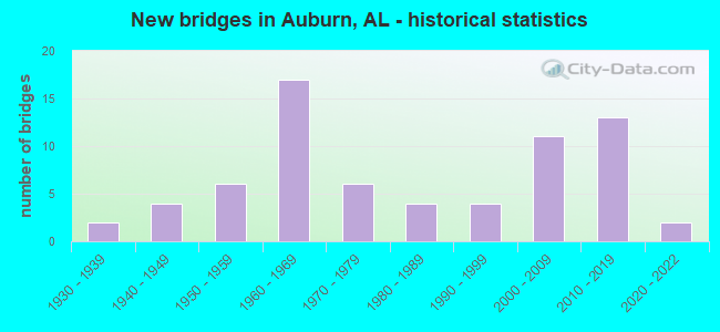
- New bridges - historical statistics
- 21930-1939
- 41940-1949
- 61950-1959
- 171960-1969
- 61970-1979
- 41980-1989
- 41990-1999
- 112000-2009
- 132010-2019
- 22020-2022
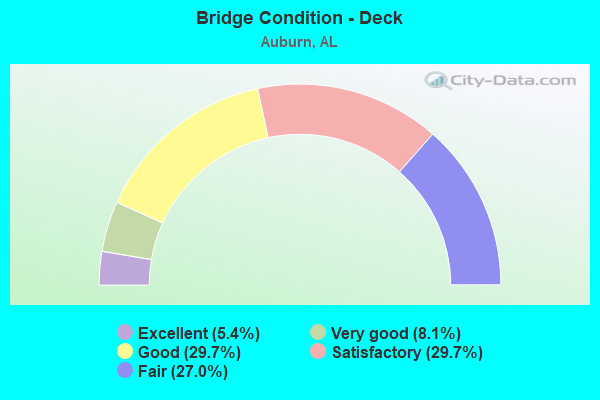
- Bridge Condition - Deck
- 5.4%Excellent
- 8.1%Very good
- 29.7%Good
- 29.7%Satisfactory
- 27.0%Fair
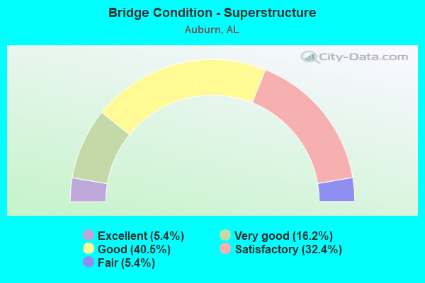
- Bridge Condition - Superstructure
- 5.4%Excellent
- 16.2%Very good
- 40.5%Good
- 32.4%Satisfactory
- 5.4%Fair
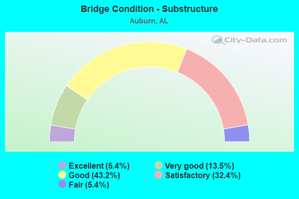
- Bridge Condition - Substructure
- 5.4%Excellent
- 13.5%Very good
- 43.2%Good
- 32.4%Satisfactory
- 5.4%Fair
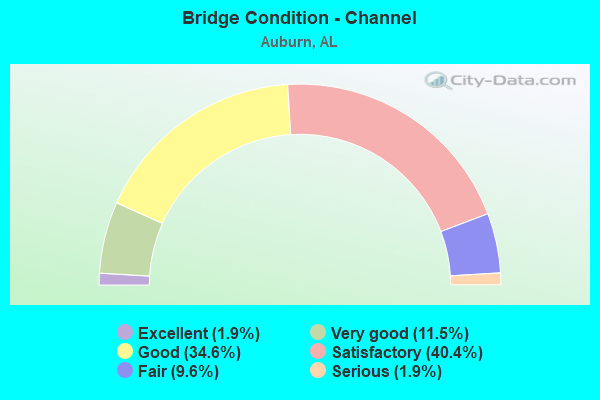
- Bridge Condition - Channel
- 1.9%Excellent
- 11.5%Very good
- 34.6%Good
- 40.4%Satisfactory
- 9.6%Fair
- 1.9%Serious
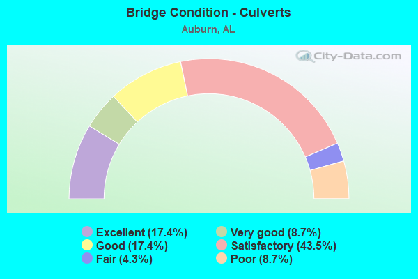
- Bridge Condition - Culverts
- 17.4%Excellent
- 8.7%Very good
- 17.4%Good
- 43.5%Satisfactory
- 4.3%Fair
- 8.7%Poor
Find on map >> Show street view
Structure Number: 18868, Location: .6 MI S JCT I85 (Lat: 32.552278, Lng: -85.509778), Route carried "on" structure: US 29, Year Built: 2005, Status: Open, Structure Length: 5.18m (16.99ft), Average Daily Traffic: 12,430 (year 2013), Truck Traffic: 7%, Average Future Daily Traffic: 16,940 (year 2033), Design Load: HS 20, Features Intersected: PARKERSON MILL CREEK
Minimum Vertical Clearance: 30+ m (98+ ft), Kilometerpoint: 288.354, Lanes on structure: 5, Owner: State Highway Agency, Approaching Roadway Width: 24.4m (80.1ft), Material/Design: Prestressed concrete, Design/Construction: Stringer/Multi-beam, Number Of Spans In Main Unit: 2, Length of Maximum Span: 25.9m (85.0ft), Curb-To-Curb Width: 24.9m (81.7ft), Out-to-Out Width: 25.6m (84.0ft)
Condition: Deck: Satisfactory, Superstructure: Good, Substructure: Good, Channel: Good, Operating Rating: 69.4 metric tons, Method Used To Determine Operating Rating: Load Factor (LF), Inventory Rating: 30.8 metric tons, Method Used To Determine Inventory Rating: Load Factor (LF), Structural Evaluation: Better than present minimum criteria, Deck Geometry: Superior to present desirable criteria, Waterway Adequacy: Superior to present desirable criteria, Approach Roadway Alignment: Better than present minimum criteria, Length Of Structure Improvement: 6.21m (20.37ft), Designated Inspection Frequency: Every 24 months, Inspection Date: July 2021, Bridge Improvement Cost: $3,574,000, Roadway Improvement Cost: $357,000, Total Project Cost: $3,931,000 ( Estimate for 2022), Deck Structure Type: Concrete Cast-file-Place
Find on map >> Show street view
Structure Number: 19157, Location: JCT I85 * US 29(EXIT51) (Lat: 32.558336, Lng: -85.506478), Route carried "on" structure: US 29, Year Built: 2005, Status: Open, Structure Length: 12.80m (41.99ft), Average Daily Traffic: 16,470 (year 2013), Truck Traffic: 7%, Average Future Daily Traffic: 22,446 (year 2033), Design Load: HS 20, Features Intersected: I-85
Minimum Vertical Clearance: 30+ m (98+ ft), Kilometerpoint: 289.119, Lanes on structure: 5, Lanes under structure: 5, Owner: State Highway Agency, Approaching Roadway Width: 30.0m (98.4ft), Skew: 5 degrees, Material/Design: Prestressed concrete, Design/Construction: Stringer/Multi-beam, Number Of Spans In Main Unit: 4, Length of Maximum Span: 41.1m (134.8ft), Curb-To-Curb Width: 29.9m (98.1ft), Out-to-Out Width: 30.7m (100.7ft)
Condition: Deck: Satisfactory, Superstructure: Good, Substructure: Satisfactory, Operating Rating: 50.0 metric tons, Method Used To Determine Operating Rating: Load Factor (LF), Inventory Rating: 27.2 metric tons, Method Used To Determine Inventory Rating: Load Factor (LF), Structural Evaluation: Equal to present minimum criteria, Deck Geometry: Superior to present desirable criteria, Underclear: Meets minimum limits, Approach Roadway Alignment: Equal to present desirable criteria, Length Of Structure Improvement: 13.63m (44.72ft), Designated Inspection Frequency: Every 24 months, Inspection Date: June 2021, Bridge Improvement Cost: $9,346,000, Roadway Improvement Cost: $935,000, Total Project Cost: $10,281,000 ( Estimate for 2022), Deck Structure Type: Concrete Cast-file-Place
Find on map >> Show street view
Structure Number: 19728, Location: JCT. BENT CREEK RD * I85 (Lat: 32.605444, Lng: -85.428556), Route carried "on" structure: County highway 43, Year Built: 2006, Status: Open, Structure Length: 8.23m (27.00ft), Average Daily Traffic: 4,070 (year 2009), Truck Traffic: 1%, Average Future Daily Traffic: 6,048 (year 2031), Design Load: HS 20, Features Intersected: I-85
Minimum Vertical Clearance: 30+ m (98+ ft), Kilometerpoint: 154.497, Lanes on structure: 5, Lanes under structure: 4, Owner: State Highway Agency, Approaching Roadway Width: 23.7m (77.8ft), Material/Design: Prestressed concrete continuous, Design/Construction: Stringer/Multi-beam, Number Of Spans In Main Unit: 2, Length of Maximum Span: 41.1m (134.8ft), Curb-To-Curb Width: 23.8m (78.1ft), Out-to-Out Width: 24.6m (80.7ft)
Condition: Deck: Good, Superstructure: Very good, Substructure: Very good, Operating Rating: 65.5 metric tons, Method Used To Determine Operating Rating: Load Factor (LF), Inventory Rating: 35.3 metric tons, Method Used To Determine Inventory Rating: Load Factor (LF), Structural Evaluation: Equal to present desirable criteria, Deck Geometry: Better than present minimum criteria, Underclear: High priority of corrective action, Approach Roadway Alignment: Better than present minimum criteria, Length Of Structure Improvement: 9.23m (30.28ft), Designated Inspection Frequency: Every 24 months, Inspection Date: August 2021, Bridge Improvement Cost: $5,063,000, Roadway Improvement Cost: $506,000, Total Project Cost: $5,569,000 ( Estimate for 2022), Deck Structure Type: Concrete Cast-file-Place
Find on map >> Show street view
Structure Number: 20115, Location: 0.5 MI W. JCT LEE ROAD 12 (Lat: 32.545647, Lng: -85.547083), Route carried "on" structure: County highway 1010, Year Built: 2008, Status: Open, Structure Length: 1.04m (3.41ft), Average Daily Traffic: 2,226 (year 2016), Truck Traffic: 10%, Average Future Daily Traffic: 3,338 (year 2036), Design Load: HS 20, Features Intersected: TRIB TO CHOCTAFAULA CRK, Facility Carried by Structure: LEE ROAD 10
Minimum Vertical Clearance: 30+ m (98+ ft), Kilometerpoint: 0.000, Lanes on structure: 3, Owner: City or Municipal Highway Agency, Approaching Roadway Width: 12.8m (42.0ft), Material/Design: Concrete, Design/Construction: Channel Beam, Number Of Spans In Main Unit: 1, Length of Maximum Span: 10.4m (34.1ft), Curb-To-Curb Width: 11.7m (38.4ft), Out-to-Out Width: 12.5m (41.0ft)
Condition: Deck: Fair, Superstructure: Good, Substructure: Good, Channel: Good, Operating Rating: 67.2 metric tons, Method Used To Determine Operating Rating: Load Factor (LF), Inventory Rating: 40.4 metric tons, Method Used To Determine Inventory Rating: Load Factor (LF), Structural Evaluation: Better than present minimum criteria, Deck Geometry: High priority of corrective action, Waterway Adequacy: Equal to present minimum criteria, Approach Roadway Alignment: Equal to present desirable criteria, Length Of Structure Improvement: 1.71m (5.61ft), Designated Inspection Frequency: Every 24 months, Inspection Date: September 2020, Bridge Improvement Cost: $480,000, Roadway Improvement Cost: $48,000, Total Project Cost: $528,000 ( Estimate for 2022), Deck Structure Type: Concrete Precast Panels
Find on map >> Show street view
Structure Number: 20276, Location: 4.7 MI NORTH OF SR8/US80 (Lat: 32.492836, Lng: -85.447136), Route carried "on" structure: County highway 43, Year Built: 2010, Status: Open, Structure Length: 3.66m (12.01ft), Average Daily Traffic: 261 (year 2010), Truck Traffic: 6%, Average Future Daily Traffic: 386 (year 2034), Design Load: HS 20, Features Intersected: COSSEY CREEK
Minimum Vertical Clearance: 30+ m (98+ ft), Kilometerpoint: 0.000, Lanes on structure: 2, Owner: County Highway Agency, Approaching Roadway Width: 8.5m (27.9ft), Material/Design: Concrete, Design/Construction: Channel Beam, Number Of Spans In Main Unit: 3, Length of Maximum Span: 12.2m (40.0ft), Curb-To-Curb Width: 8.5m (27.9ft), Out-to-Out Width: 9.1m (29.9ft)
Condition: Deck: Good, Superstructure: Good, Substructure: Very good, Channel: Very good, Operating Rating: 79.8 metric tons, Method Used To Determine Operating Rating: Load Factor (LF), Inventory Rating: 46.9 metric tons, Method Used To Determine Inventory Rating: Load Factor (LF), Structural Evaluation: Better than present minimum criteria, Deck Geometry: Equal to present minimum criteria, Waterway Adequacy: Equal to present desirable criteria, Approach Roadway Alignment: Equal to present desirable criteria, Length Of Structure Improvement: 4.58m (15.03ft), Designated Inspection Frequency: Every 24 months, Inspection Date: December 2020, Bridge Improvement Cost: $942,000, Roadway Improvement Cost: $94,000, Total Project Cost: $1,036,000 ( Estimate for 2022), Deck Structure Type: Concrete Precast Panels
Find on map >> Show street view
Structure Number: 20284, Location: 1.9 MI NW SR29/AL15 (Lat: 32.504208, Lng: -85.575194), Route carried "on" structure: County highway 54, Year Built: 2009, Status: Open, Structure Length: 1.04m (3.41ft), Average Daily Traffic: 75 (year 2015), Average Future Daily Traffic: 100 (year 2035), Design Load: HS 20, Features Intersected: UNNAMED BRANCH
Minimum Vertical Clearance: 0.00m, Kilometerpoint: 0.000, Lanes on structure: 2, Owner: County Highway Agency, Approaching Roadway Width: 7.5m (24.6ft), Material/Design: Concrete, Design/Construction: Channel Beam, Number Of Spans In Main Unit: 1, Length of Maximum Span: 10.4m (34.1ft), Curb-To-Curb Width: 7.5m (24.6ft), Out-to-Out Width: 8.5m (27.9ft)
Condition: Deck: Excellent, Superstructure: Excellent, Substructure: Excellent, Channel: Very good, Operating Rating: 75.2 metric tons, Method Used To Determine Operating Rating: Load Factor (LF), Inventory Rating: 45.2 metric tons, Method Used To Determine Inventory Rating: Load Factor (LF), Structural Evaluation: Superior to present desirable criteria, Deck Geometry: High priority of corrective action, Waterway Adequacy: Equal to present desirable criteria, Approach Roadway Alignment: Better than present minimum criteria, Length Of Structure Improvement: 1.71m (5.61ft), Designated Inspection Frequency: Every 24 months, Inspection Date: October 2021, Bridge Improvement Cost: $316,000, Roadway Improvement Cost: $32,000, Total Project Cost: $348,000 ( Estimate for 2022), Deck Structure Type: Concrete Precast Panels
Find on map >> Show street view
Structure Number: 20356, Location: 1.5 MI S JCT US29(EXIT50) (Lat: 32.547261, Lng: -85.527814), Route carried "on" structure: City street 12, Year Built: 2012, Status: Open, Structure Length: 8.54m (28.02ft), Average Daily Traffic: 1,000 (year 2012), Truck Traffic: 1%, Average Future Daily Traffic: 1,400 (year 2034), Design Load: HS 20, Features Intersected: I85
Minimum Vertical Clearance: 30+ m (98+ ft), Kilometerpoint: 3.460, Lanes on structure: 5, Lanes under structure: 4, Owner: State Highway Agency, Approaching Roadway Width: 25.0m (82.0ft), Material/Design: Prestressed concrete, Design/Construction: Stringer/Multi-beam, Number Of Spans In Main Unit: 2, Length of Maximum Span: 42.1m (138.1ft), Curb-To-Curb Width: 28.2m (92.5ft), Out-to-Out Width: 28.8m (94.5ft)
Condition: Deck: Good, Superstructure: Good, Substructure: Good, Channel: Good, Operating Rating: 88.9 metric tons, Method Used To Determine Operating Rating: Load Factor (LF), Inventory Rating: 45.7 metric tons, Method Used To Determine Inventory Rating: Load Factor (LF), Structural Evaluation: Better than present minimum criteria, Deck Geometry: Superior to present desirable criteria, Underclear: Better than present minimum criteria, Approach Roadway Alignment: Equal to present desirable criteria, Length Of Structure Improvement: 9.53m (31.27ft), Designated Inspection Frequency: Every 24 months, Inspection Date: November 2021, Bridge Improvement Cost: $6,140,000, Roadway Improvement Cost: $614,000, Total Project Cost: $6,754,000 ( Estimate for 2022), Deck Structure Type: Concrete Cast-file-Place
Find on map >> Show street view
Structure Number: 20403, Location: 700 FT E OF CHADWICK LANE (Lat: 32.568881, Lng: -85.544703), Route carried "on" structure: City street , Year Built: 2010, Status: Open, Structure Length: 1.29m (4.23ft), Average Daily Traffic: 13,000 (year 2010), Truck Traffic: 16%, Average Future Daily Traffic: 18,205 (year 2030), Design Load: HS 20, Features Intersected: CHOCLAUGALA CREEK, Facility Carried by Structure: WIRE ROAD
Minimum Vertical Clearance: 30+ m (98+ ft), Kilometerpoint: 0.010, Lanes on structure: 2, Owner: City or Municipal Highway Agency, Approaching Roadway Width: 8.2m (26.9ft), Material/Design: Concrete, Design/Construction: Channel Beam, Number Of Spans In Main Unit: 1, Length of Maximum Span: 12.9m (42.3ft), Curb or Sidewalk Widths: Left: 3.6m (11.8ft), Right: 0.0m, Curb-To-Curb Width: 9.0m (29.5ft), Out-to-Out Width: 9.6m (31.5ft)
Condition: Deck: Very good, Superstructure: Very good, Substructure: Very good, Channel: Good, Operating Rating: 88.9 metric tons, Method Used To Determine Operating Rating: Load Factor (LF), Inventory Rating: 54.3 metric tons, Method Used To Determine Inventory Rating: Load Factor (LF), Structural Evaluation: Equal to present desirable criteria, Deck Geometry: High priority of replacement, Waterway Adequacy: Superior to present desirable criteria, Approach Roadway Alignment: Equal to present desirable criteria, Length Of Structure Improvement: 1.96m (6.43ft), Designated Inspection Frequency: Every 24 months, Inspection Date: March 2020, Bridge Improvement Cost: $416,000, Roadway Improvement Cost: $42,000, Total Project Cost: $458,000 ( Estimate for 2022), Deck Structure Type: Concrete Precast Panels
Find on map >> Show street view
Structure Number: 20485, Location: 0.9 MI NORTH ALA 267 (Lat: 32.642383, Lng: -85.504503), Route carried "on" structure: City street 82, Year Built: 2011, Status: Open, Structure Length: 6.49m (21.29ft), Average Daily Traffic: 4,860 (year 2009), Average Future Daily Traffic: 6,804 (year 2031), Design Load: HS 20, Features Intersected: SAUGAHATCHEE CREEK, Facility Carried by Structure: N. DONAHUE DRIVE
Minimum Vertical Clearance: 30+ m (98+ ft), Kilometerpoint: 1.452, Lanes on structure: 3, Owner: City or Municipal Highway Agency, Approaching Roadway Width: 11.3m (37.1ft), Material/Design: Prestressed concrete, Design/Construction: Stringer/Multi-beam, Number Of Spans In Main Unit: 3, Length of Maximum Span: 25.7m (84.3ft), Curb-To-Curb Width: 14.9m (48.9ft), Out-to-Out Width: 19.4m (63.6ft)
Condition: Deck: Excellent, Superstructure: Excellent, Substructure: Excellent, Channel: Good, Operating Rating: 72.7 metric tons, Method Used To Determine Operating Rating: Load Factor (LF), Inventory Rating: 43.5 metric tons, Method Used To Determine Inventory Rating: Load Factor (LF), Structural Evaluation: Superior to present desirable criteria, Deck Geometry: Equal to present minimum criteria, Waterway Adequacy: Equal to present desirable criteria, Approach Roadway Alignment: Superior to present desirable criteria, Length Of Structure Improvement: 7.52m (24.67ft), Designated Inspection Frequency: Every 24 months, Inspection Date: April 2021, Bridge Improvement Cost: $3,251,000, Roadway Improvement Cost: $325,000, Total Project Cost: $3,576,000 ( Estimate for 2022), Deck Structure Type: Concrete Cast-file-Place
Find on map >> Show street view
Structure Number: 20532, Location: 3.5 Miles North Jct US 29 (Lat: 32.589389, Lng: -85.458889), Route carried "on" structure: County highway 12, Year Built: 2017, Status: Open, Structure Length: 7.32m (24.02ft), Average Daily Traffic: 12,251 (year 2016), Truck Traffic: 10%, Average Future Daily Traffic: 18,204 (year 2036), Design Load: HS 20, Features Intersected: IN 85, Facility Carried by Structure: Moores Mill Road
Minimum Vertical Clearance: 30+ m (98+ ft), Kilometerpoint: 54.969, Lanes on structure: 4, Lanes under structure: 4, Owner: State Highway Agency, Approaching Roadway Width: 22.6m (74.1ft), Material/Design: Prestressed concrete, Design/Construction: Stringer/Multi-beam, Number Of Spans In Main Unit: 2, Length of Maximum Span: 36.6m (120.1ft), Curb or Sidewalk Widths: Left: 0.0m, Right: 3.4m (11.2ft), Curb-To-Curb Width: 18.9m (62.0ft), Out-to-Out Width: 26.7m (87.6ft)
Condition: Deck: Good, Superstructure: Very good, Substructure: Good, Operating Rating: 88.9 metric tons, Method Used To Determine Operating Rating: Load Factor (LF), Inventory Rating: 26.7 metric tons, Method Used To Determine Inventory Rating: Load Factor (LF), Structural Evaluation: Equal to present minimum criteria, Deck Geometry: Equal to present minimum criteria, Underclear: High priority of replacement, Approach Roadway Alignment: Better than present minimum criteria, Length Of Structure Improvement: 8.34m (27.36ft), Designated Inspection Frequency: Every 24 months, Inspection Date: January 2021, Bridge Improvement Cost: $4,976,000, Roadway Improvement Cost: $498,000, Total Project Cost: $5,474,000 ( Estimate for 2022), Deck Structure Type: Concrete Cast-file-Place
Find on map >> Show street view
Structure Number: 20533, Location: 1.5 mi e jct s 015 (Lat: 32.535983, Lng: -85.496750), Route carried "on" structure: County highway 1010, Year Built: 2015, Status: Open, Structure Length: 3.51m (11.52ft), Average Daily Traffic: 2,400 (year 2021), Truck Traffic: 15%, Average Future Daily Traffic: 3,600 (year 2041), Design Load: HS 20, Features Intersected: CHEWACLA CREEK, Facility Carried by Structure: Lee Road 10
Minimum Vertical Clearance: 30+ m (98+ ft), Kilometerpoint: 0.010, Lanes on structure: 2, Owner: County Highway Agency, Approaching Roadway Width: 7.3m (24.0ft), Material/Design: Prestressed concrete, Design/Construction: Stringer/Multi-beam, Number Of Spans In Main Unit: 1, Length of Maximum Span: 35.1m (115.2ft), Curb-To-Curb Width: 9.1m (29.9ft), Out-to-Out Width: 10.0m (32.8ft)
Condition: Deck: Very good, Superstructure: Very good, Substructure: Very good, Channel: Good, Operating Rating: 88.9 metric tons, Method Used To Determine Operating Rating: Load Factor (LF), Inventory Rating: 53.8 metric tons, Method Used To Determine Inventory Rating: Load Factor (LF), Structural Evaluation: Equal to present desirable criteria, Deck Geometry: Meets minimum limits, Waterway Adequacy: Better than present minimum criteria, Approach Roadway Alignment: Better than present minimum criteria, Length Of Structure Improvement: 4.41m (14.47ft), Designated Inspection Frequency: Every 24 months, Inspection Date: May 2021, Bridge Improvement Cost: $967,000, Roadway Improvement Cost: $97,000, Total Project Cost: $1,064,000 ( Estimate for 2022), Deck Structure Type: Concrete Cast-file-Place
Find on map >> Show street view
Structure Number: 20912, Location: 0.7 MI NW I-85 (Lat: 32.595000, Lng: -85.470000), Route carried "on" structure: City street 1146, Year Built: 2014, Status: Open, Structure Length: 0.85m (2.79ft), Average Daily Traffic: 3,011 (year 2014), Truck Traffic: 9%, Average Future Daily Traffic: 7,754 (year 2035), Design Load: HS 20, Features Intersected: MOORE'S MILL CREEK, Facility Carried by Structure: LEE CO 146
Minimum Vertical Clearance: 30+ m (98+ ft), Kilometerpoint: 0.010, Lanes on structure: 2, Owner: City or Municipal Highway Agency, Approaching Roadway Width: 7.0m (23.0ft), Material/Design: Concrete, Design/Construction: Culvert, Number Of Spans In Main Unit: 3, Length of Maximum Span: 2.4m (7.9ft), Curb-To-Curb Width: 7.0m (23.0ft), Out-to-Out Width: 7.0m (23.0ft)
Condition: Channel: Satisfactory, Culverts: Excellent, Operating Rating: 49.5 metric tons, Method Used To Determine Operating Rating: Load Factor (LF), Inventory Rating: 29.7 metric tons, Method Used To Determine Inventory Rating: Load Factor (LF), Structural Evaluation: Better than present minimum criteria, Deck Geometry: High priority of replacement, Waterway Adequacy: Equal to present minimum criteria, Approach Roadway Alignment: Equal to present minimum criteria, Length Of Structure Improvement: 1.51m (4.95ft), Designated Inspection Frequency: Every 24 months, Inspection Date: March 2020, Bridge Improvement Cost: $236,000, Roadway Improvement Cost: $24,000, Total Project Cost: $260,000 ( Estimate for 2022)
Find on map >> Show street view
Structure Number: 21035, Location: 2.0 MI S JCT LEE RD 72 (Lat: 32.667289, Lng: -85.627458), Route carried "on" structure: County highway 1070, Year Built: 2014, Status: Open, Structure Length: 1.22m (4.00ft), Average Daily Traffic: 23 (year 2020), Average Future Daily Traffic: 35 (year 2040), Design Load: HS 20, Features Intersected: BIRD CREEK, Facility Carried by Structure: Lee Road 70
Minimum Vertical Clearance: 30+ m (98+ ft), Kilometerpoint: 0.010, Lanes on structure: 2, Owner: County Highway Agency, Approaching Roadway Width: 5.5m (18.0ft), Material/Design: Steel, Design/Construction: Stringer/Multi-beam, Number Of Spans In Main Unit: 1, Length of Maximum Span: 12.2m (40.0ft), Curb-To-Curb Width: 7.9m (25.9ft), Out-to-Out Width: 9.1m (29.9ft)
Condition: Deck: Very good, Superstructure: Very good, Substructure: Very good, Channel: Good, Operating Rating: 59.2 metric tons, Method Used To Determine Operating Rating: Load Factor (LF), Inventory Rating: 35.5 metric tons, Method Used To Determine Inventory Rating: Load Factor (LF), Structural Evaluation: Equal to present desirable criteria, Deck Geometry: Equal to present minimum criteria, Waterway Adequacy: Better than present minimum criteria, Approach Roadway Alignment: Equal to present minimum criteria, Length Of Structure Improvement: 1.89m (6.20ft), Designated Inspection Frequency: Every 24 months, Inspection Date: November 2020, Bridge Improvement Cost: $389,000, Roadway Improvement Cost: $39,000, Total Project Cost: $428,000 ( Estimate for 2022), Deck Structure Type: Concrete Cast-file-Place
Find on map >> Show street view
Structure Number: 21158, Location: 0.8MI E JCT Lee Road 188 (Lat: 32.566783, Lng: -85.598267), Route carried "on" structure: County highway 1393, Year Built: 2018, Status: Open, Structure Length: 1.13m (3.71ft), Average Daily Traffic: 107 (year 2020), Truck Traffic: 20%, Average Future Daily Traffic: 160 (year 2040), Design Load: HS 20, Features Intersected: HODNETT CREEK, Facility Carried by Structure: Lee Road 393
Minimum Vertical Clearance: 30+ m (98+ ft), Kilometerpoint: 0.010, Lanes on structure: 2, Owner: County Highway Agency, Approaching Roadway Width: 5.5m (18.0ft), Material/Design: Concrete, Design/Construction: Culvert, Number Of Spans In Main Unit: 3, Length of Maximum Span: 3.7m (12.1ft)
Condition: Channel: Good, Culverts: Excellent, Operating Rating: 42.4 metric tons, Method Used To Determine Operating Rating: Load Factor (LF), Inventory Rating: 25.3 metric tons, Method Used To Determine Inventory Rating: Load Factor (LF), Structural Evaluation: Equal to present minimum criteria, Waterway Adequacy: Equal to present desirable criteria, Approach Roadway Alignment: Equal to present minimum criteria, Length Of Structure Improvement: 1.81m (5.94ft), Designated Inspection Frequency: Every 24 months, Inspection Date: April 2020, Bridge Improvement Cost: $313,000, Roadway Improvement Cost: $31,000, Total Project Cost: $344,000 ( Estimate for 2022)
Find on map >> Show street view
Structure Number: 21574, Location: _150' from wire road (Lat: 32.596900, Lng: -85.429786), Route carried "on" structure: State lands road , Year Built: 2010, Status: Open, Structure Length: 0.67m (2.20ft), Average Daily Traffic: 3,000 (year 2008), Truck Traffic: 2%, Average Future Daily Traffic: 3,550 (year 2035), Features Intersected: _Parkerson Mill Branch, Facility Carried by Structure: _W Samford Ave
Minimum Vertical Clearance: 30+ m (98+ ft), Kilometerpoint: 3.219, Lanes on structure: 3, Owner: State Agenciy, Approaching Roadway Width: 16.8m (55.1ft), Skew: 6 degrees, Material/Design: Concrete, Design/Construction: Culvert, Number Of Spans In Main Unit: 2, Length of Maximum Span: 3.4m (11.2ft)
Condition: Channel: Good, Culverts: Good, Operating Rating: 59.3 metric tons, Method Used To Determine Operating Rating: Load Factor (LF), Inventory Rating: 35.5 metric tons, Method Used To Determine Inventory Rating: Load Factor (LF), Structural Evaluation: Better than present minimum criteria, Waterway Adequacy: Superior to present desirable criteria, Approach Roadway Alignment: Better than present minimum criteria, Length Of Structure Improvement: 1.30m (4.27ft), Designated Inspection Frequency: Every 24 months, Inspection Date: May 2020, Bridge Improvement Cost: $901,000, Roadway Improvement Cost: $90,000, Total Project Cost: $991,000 ( Estimate for 2022)
Find on map >> Show street view
Structure Number: 2159, Location: _ (Lat: 32.562200, Lng: -85.465000), Route carried "on" structure: City street 4, Year Built: 2021, Status: Open, Structure Length: 1.38m (4.53ft), Average Daily Traffic: 2,709 (year 2021), Truck Traffic: 4%, Average Future Daily Traffic: 4,334 (year 2041), Design Load: HS 20, Features Intersected: _Moore's Mill Creek, Facility Carried by Structure: _Ogletree Rd
Minimum Vertical Clearance: 30+ m (98+ ft), Kilometerpoint: 0.010, Lanes on structure: 2, Owner: City or Municipal Highway Agency, Approaching Roadway Width: 8.8m (28.9ft), Skew: 3 degrees, Material/Design: Concrete, Design/Construction: Culvert, Number Of Spans In Main Unit: 1, Length of Maximum Span: 6.8m (22.3ft), Curb or Sidewalk Widths: Left: 0.4m (1.3ft), Right: 0.4m (1.3ft), Curb-To-Curb Width: 8.8m (28.9ft), Out-to-Out Width: 20.0m (65.6ft)
Condition: Channel: Excellent, Culverts: Excellent, Operating Rating: 88.9 metric tons, Method Used To Determine Operating Rating: Load Factor (LF), Inventory Rating: 88.9 metric tons, Method Used To Determine Inventory Rating: Load Factor (LF), Structural Evaluation: Superior to present desirable criteria, Deck Geometry: Meets minimum limits, Waterway Adequacy: Superior to present desirable criteria, Approach Roadway Alignment: Superior to present desirable criteria, Length Of Structure Improvement: 2.05m (6.73ft), Designated Inspection Frequency: Every 24 months, Inspection Date: June 2021, Bridge Improvement Cost: $935,000, Roadway Improvement Cost: $94,000, Total Project Cost: $1,029,000 ( Estimate for 2022)
Find on map >> Show street view
Structure Number: 21597, Location: _ (Lat: 32.657953, Lng: -85.537125), Route carried "on" structure: City street 72, Year Built: 2021, Status: Open, Structure Length: 1.07m (3.51ft), Average Daily Traffic: 4,137 (year 2021), Truck Traffic: 4%, Average Future Daily Traffic: 6,072 (year 2041), Design Load: HS 20, Features Intersected: _Spillway Drainage
Minimum Vertical Clearance: 30+ m (98+ ft), Kilometerpoint: 0.000, Lanes on structure: 2, Owner: City or Municipal Highway Agency, Approaching Roadway Width: 6.7m (22.0ft), Skew: 3 degrees, Material/Design: Concrete, Design/Construction: Culvert, Number Of Spans In Main Unit: 3, Length of Maximum Span: 3.0m (9.8ft), Curb or Sidewalk Widths: Left: 0.4m (1.3ft), Right: 0.4m (1.3ft), Curb-To-Curb Width: 6.7m (22.0ft), Out-to-Out Width: 16.5m (54.1ft)
Condition: Channel: Very good, Culverts: Excellent, Operating Rating: 88.9 metric tons, Method Used To Determine Operating Rating: Load Factor (LF), Inventory Rating: 65.4 metric tons, Method Used To Determine Inventory Rating: Load Factor (LF), Structural Evaluation: Superior to present desirable criteria, Deck Geometry: High priority of replacement, Waterway Adequacy: Equal to present minimum criteria, Approach Roadway Alignment: Equal to present desirable criteria, Length Of Structure Improvement: 1.75m (5.74ft), Designated Inspection Frequency: Every 24 months, Inspection Date: May 2021, Bridge Improvement Cost: $657,000, Roadway Improvement Cost: $66,000, Total Project Cost: $723,000 ( Estimate for 2022)
Find on map >> Show street view
Structure Number: 8010700000306, Location: TUSKEGEE DISTRICT (Lat: 32.490278, Lng: -85.602222), Route carried "on" structure: Federal lands road 906.1, Year Built: 1966, Status: Posted for load, Structure Length: 6.92m (22.70ft), Average Daily Traffic: 50 (year 1992), Average Future Daily Traffic: 75 (year 2042), Design Load: H 10, Features Intersected: CHOCTAFAULA CREEK, Facility Carried by Structure: FDR 706
Minimum Vertical Clearance: 30+ m (98+ ft), Kilometerpoint: 1.600, Lanes on structure: 1, Owner: U.S. Forest Service, Approaching Roadway Width: 4.9m (16.1ft), Material/Design: Concrete, Design/Construction: Stringer/Multi-beam, Number Of Spans In Main Unit: 15, Length of Maximum Span: 4.6m (15.1ft), Curb or Sidewalk Widths: Left: 0.3m (1.0ft), Right: 0.3m (1.0ft), Curb-To-Curb Width: 4.9m (16.1ft), Out-to-Out Width: 5.5m (18.0ft)
Condition: Deck: Good, Superstructure: Good, Substructure: Satisfactory, Channel: Good, Operating Rating: 5.8 metric tons, Method Used To Determine Operating Rating: Load and Resistance Factor Rating (LRFR) rating reported by rating factor(RF) method using HL-93 loadings, Inventory Rating: 4.5 metric tons, Method Used To Determine Inventory Rating: Load and Resistance Factor Rating (LRFR) rating reported by rating factor(RF) method using HL-93 loadings, Structural Evaluation: High priority of corrective action, Deck Geometry: High priority of corrective action, Waterway Adequacy: Better than present minimum criteria, Approach Roadway Alignment: Equal to present desirable criteria, Bridge Posting: Required (Relationship of Operating Rating to Maximum Legal Load: > 39.9% below), Designated Inspection Frequency: Every 24 months, Inspection Date: November 2021, Deck Structure Type: Concrete Cast-file-Place, Wearing Surface/Protective System: Wearing Surface: Monolithic Concrete
Find on map >> Show street view
Structure Number: 8010700001207, Location: NO DATA ENTERED (Lat: 32.504011, Lng: -85.594700), Route carried "on" structure: Federal lands road 910, Year Built: 2010, Status: Open, Structure Length: 1.68m (5.51ft), Average Daily Traffic: 50 (year 0000), Average Future Daily Traffic: 75 (year 2042), Design Load: HS 20, Features Intersected: HODNETT CREEK
Minimum Vertical Clearance: 30+ m (98+ ft), Kilometerpoint: 2.486, Lanes on structure: 1, Owner: U.S. Forest Service, Approaching Roadway Width: 4.3m (14.1ft), Material/Design: Concrete, Design/Construction: Box Beam or Girders - Multiple, Number Of Spans In Main Unit: 1, Length of Maximum Span: 16.8m (55.1ft), Curb-To-Curb Width: 4.3m (14.1ft), Out-to-Out Width: 4.9m (16.1ft)
Condition: Deck: Good, Superstructure: Good, Substructure: Good, Channel: Satisfactory, Operating Rating: 31.4 metric tons, Method Used To Determine Operating Rating: Load and Resistance Factor Rating (LRFR) rating reported by rating factor(RF) method using HL-93 loadings, Inventory Rating: 24.0 metric tons, Method Used To Determine Inventory Rating: Load and Resistance Factor Rating (LRFR) rating reported by rating factor(RF) method using HL-93 loadings, Structural Evaluation: Equal to present minimum criteria, Deck Geometry: Equal to present minimum criteria, Waterway Adequacy: Better than present minimum criteria, Approach Roadway Alignment: Equal to present desirable criteria, Designated Inspection Frequency: Every 24 months, Inspection Date: November 2021, Deck Structure Type: Concrete Precast Panels
Find on map >> Show street view
Structure Number: 6101, Location: 2.6 MI N JCT US 29 (Lat: 32.580500, Lng: -85.469944), Route carried "under" structure: Interstate 85, Year Built: 1958, Structure Length: 0. m, Average Daily Traffic: 35,990 (year 2013), Truck Traffic: 25%, Features Intersected: I-85, Facility Carried by Structure: WRIGHTS MILL ROAD
Minimum Vertical Clearance: 5.30m (17.39ft), Kilometerpoint: 86.879, Lanes on structure: 2, Lanes under structure: 4, Material/Design: Concrete continuous, Design/Construction: Tee Beam, Length of Maximum Span: 29.3m (96.1ft)
Find on map >> Show street view
Structure Number: 8595, Location: 2 MI S JCT US 29 (Lat: 32.542956, Lng: -85.534781), Route carried "under" structure: Interstate 85, Year Built: 1965, Structure Length: 0. m, Average Daily Traffic: 31,380 (year 2013), Truck Traffic: 27%, Features Intersected: I-85, Facility Carried by Structure: CO RD 10-(BEEHIVE)
Minimum Vertical Clearance: 5.55m (18.21ft), Kilometerpoint: 79.645, Lanes on structure: 2, Lanes under structure: 4, Material/Design: Concrete continuous, Design/Construction: Tee Beam, Length of Maximum Span: 22.9m (75.1ft)
Find on map >> Show street view
Structure Number: 8603, Location: 3.59 MI.N OF AL.186 (Lat: 32.513958, Lng: -85.585575), Route carried "under" structure: Interstate 85, Year Built: 1965, Structure Length: 0. m, Average Daily Traffic: 31,380 (year 2013), Truck Traffic: 27%, Features Intersected: I85, Facility Carried by Structure: CO RD 54
Minimum Vertical Clearance: 5.01m (16.44ft), Kilometerpoint: 73.743, Lanes on structure: 2, Lanes under structure: 4, Material/Design: Concrete continuous, Design/Construction: Tee Beam, Length of Maximum Span: 21.3m (69.9ft)
Find on map >> Show street view
Structure Number: 1011, Location: JCT AL 14 * AL 147 (Lat: 32.607389, Lng: -85.510694), Route carried "under" structure: State highway 14, Year Built: 1969, Structure Length: 0. m, Average Daily Traffic: 9,900 (year 2013), Truck Traffic: 5%, Features Intersected: AL 14 * CSX RAILROAD
Minimum Vertical Clearance: 5.64m (18.50ft), Kilometerpoint: 350.361, Lanes on structure: 4, Lanes under structure: 3, Material/Design: Steel continuous, Design/Construction: Stringer/Multi-beam, Length of Maximum Span: 25.0m (82.0ft)
Find on map >> Show street view
Structure Number: 10946, Location: AL.15*AL.#186 (Lat: 32.485000, Lng: -85.577667), Route carried "under" structure: State highway 186, Year Built: 1973, Structure Length: 0. m, Average Daily Traffic: 2,220 (year 2013), Truck Traffic: 5%, Features Intersected: AL 186, Facility Carried by Structure: AL 15
Minimum Vertical Clearance: 30+ m (98+ ft), Kilometerpoint: 6.161, Lanes on structure: 3, Lanes under structure: 4, Material/Design: Steel continuous, Design/Construction: Stringer/Multi-beam, Length of Maximum Span: 26.5m (86.9ft)
Find on map >> Show street view
Structure Number: 19157, Location: JCT I85 * US 29(EXIT51) (Lat: 32.558336, Lng: -85.506478), Route carried "under" structure: Interstate 85, Year Built: 2005, Structure Length: 0. m, Average Daily Traffic: 31,570 (year 2013), Truck Traffic: 27%, Features Intersected: I-85, Facility Carried by Structure: US 29
Minimum Vertical Clearance: 5.88m (19.29ft), Kilometerpoint: 82.704, Lanes on structure: 5, Lanes under structure: 5, Material/Design: Prestressed concrete, Design/Construction: Stringer/Multi-beam, Length of Maximum Span: 41.1m (134.8ft)
Find on map >> Show street view
Structure Number: 19728, Location: JCT. BENT CREEK RD * I85 (Lat: 32.605444, Lng: -85.428556), Route carried "under" structure: Interstate 85, Year Built: 2006, Structure Length: 0. m, Average Daily Traffic: 40,660 (year 2013), Truck Traffic: 25%, Features Intersected: I-85, Facility Carried by Structure: CO 43
Minimum Vertical Clearance: 5.39m (17.68ft), Kilometerpoint: 91.708, Lanes on structure: 5, Lanes under structure: 4, Material/Design: Prestressed concrete continuous, Design/Construction: Stringer/Multi-beam, Length of Maximum Span: 41.1m (134.8ft)
Find on map >> Show street view
Structure Number: 20356, Location: 1.5 MI S JCT US29(EXIT50) (Lat: 32.547261, Lng: -85.527814), Route carried "under" structure: Interstate 85, Year Built: 2012, Structure Length: 0. m, Average Daily Traffic: 31,570 (year 2013), Truck Traffic: 27%, Features Intersected: I85, Facility Carried by Structure: MU12
Minimum Vertical Clearance: 5.58m (18.31ft), Kilometerpoint: 80.467, Lanes on structure: 5, Lanes under structure: 4, Material/Design: Prestressed concrete, Design/Construction: Stringer/Multi-beam, Length of Maximum Span: 42.1m (138.1ft)
Find on map >> Show street view
Structure Number: 20532, Location: 3.5 Miles North Jct US 29 (Lat: 32.589389, Lng: -85.458889), Route carried "under" structure: County highway 12, Year Built: 2017, Structure Length: 0. m, Average Daily Traffic: 40,660 (year 2013), Truck Traffic: 25%, Features Intersected: IN 85, Facility Carried by Structure: Moores Mill Road
Minimum Vertical Clearance: 5.56m (18.24ft), Kilometerpoint: 0.010, Lanes on structure: 4, Lanes under structure: 4, Material/Design: Prestressed concrete, Design/Construction: Stringer/Multi-beam, Length of Maximum Span: 36.6m (120.1ft)