Bridge Statistics for Athens, Alabama (AL)
Condition, Traffic, Stress, Structural Evaluation, Project Costs
- National Bridge Inventory (NBI) Statistics
- 134Number of bridges
- 1,283ft / 391mTotal length
- $140,259,000Total costs
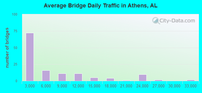
- 828,327Total average daily traffic
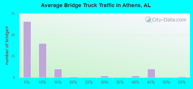
- 149,555Total average daily truck traffic
- National Bridge Inventory (NBI) Registered Bridges for Athens
- No street view available for this location
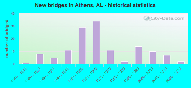
- New bridges - historical statistics
- 11910-1919
- 81920-1929
- 51930-1939
- 111940-1949
- 291950-1959
- 341960-1969
- 111970-1979
- 21980-1989
- 141990-1999
- 102000-2009
- 72010-2019
- 22020-2022
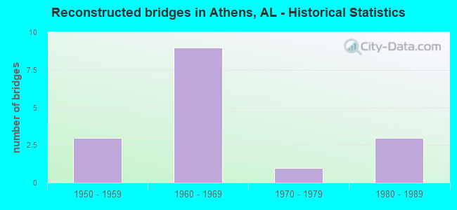
- Reconstructed bridges - Historical Statistics
- 31950-1959
- 91960-1969
- 11970-1979
- 31980-1989
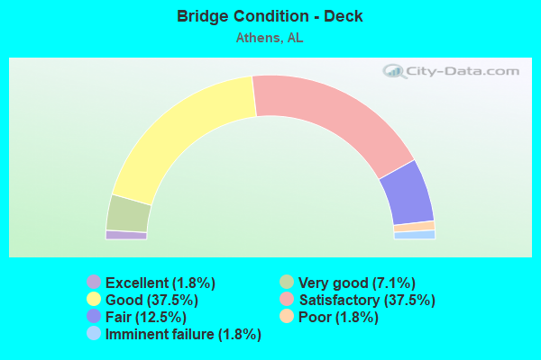
- Bridge Condition - Deck
- 1.8%Excellent
- 7.1%Very good
- 37.5%Good
- 37.5%Satisfactory
- 12.5%Fair
- 1.8%Poor
- 1.8%Imminent failure
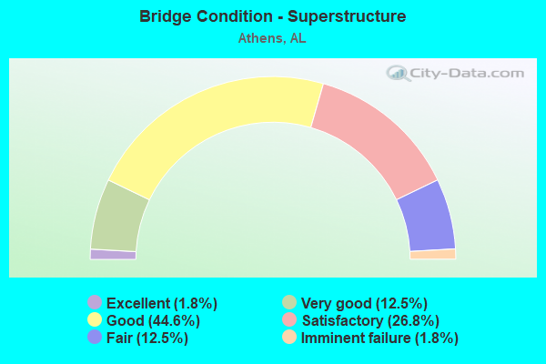
- Bridge Condition - Superstructure
- 1.8%Excellent
- 12.5%Very good
- 44.6%Good
- 26.8%Satisfactory
- 12.5%Fair
- 1.8%Imminent failure
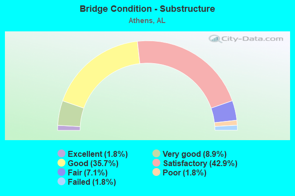
- Bridge Condition - Substructure
- 1.8%Excellent
- 8.9%Very good
- 35.7%Good
- 42.9%Satisfactory
- 7.1%Fair
- 1.8%Poor
- 1.8%Failed
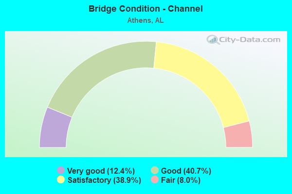
- Bridge Condition - Channel
- 12.4%Very good
- 40.7%Good
- 38.9%Satisfactory
- 8.0%Fair

- Bridge Condition - Culverts
- 11.8%Very good
- 41.2%Good
- 39.7%Satisfactory
- 7.4%Fair
Find on map >> Show street view
Structure Number: 21072, Location: _.1 mile s. us 72 (Lat: 34.785533, Lng: -86.960700), Route carried "on" structure: City street , Year Built: 2015, Status: Open, Structure Length: 4.88m (16.01ft), Average Daily Traffic: 500 (year 2015), Truck Traffic: 1%, Average Future Daily Traffic: 1,800 (year 2035), Design Load: HS 20, Features Intersected: _branch, Facility Carried by Structure: _french farms road
Minimum Vertical Clearance: 30+ m (98+ ft), Kilometerpoint: 1.127, Lanes on structure: 2, Owner: City or Municipal Highway Agency, Approaching Roadway Width: 8.3m (27.2ft), Material/Design: Prestressed concrete, Design/Construction: Stringer/Multi-beam, Number Of Spans In Main Unit: 2, Length of Maximum Span: 24.4m (80.1ft), Curb or Sidewalk Widths: Left: 0.0m, Right: 2.7m (8.9ft), Curb-To-Curb Width: 7.3m (24.0ft), Out-to-Out Width: 12.1m (39.7ft)
Condition: Deck: Very good, Superstructure: Very good, Substructure: Very good, Channel: Satisfactory, Operating Rating: 51.9 metric tons, Method Used To Determine Operating Rating: Load Factor (LF), Inventory Rating: 36.0 metric tons, Method Used To Determine Inventory Rating: Load Factor (LF), Structural Evaluation: Equal to present desirable criteria, Deck Geometry: Meets minimum limits, Waterway Adequacy: Equal to present minimum criteria, Approach Roadway Alignment: Equal to present minimum criteria, Length Of Structure Improvement: 5.89m (19.32ft), Designated Inspection Frequency: Every 24 months, Inspection Date: Febuary 2021, Bridge Improvement Cost: $1,575,000, Roadway Improvement Cost: $158,000, Total Project Cost: $1,733,000 ( Estimate for 2022), Deck Structure Type: Concrete Cast-file-Place
Find on map >> Show street view
Structure Number: 21241, Location: _5th Ave. And Town Creek (Lat: 34.812367, Lng: -86.979217), Route carried "on" structure: City street 5, Year Built: 1996, Status: Open, Structure Length: 1.25m (4.10ft), Average Daily Traffic: 350 (year 2008), Truck Traffic: 1%, Average Future Daily Traffic: 1,250 (year 2032), Design Load: HS 20, Features Intersected: town creek
Minimum Vertical Clearance: 30+ m (98+ ft), Kilometerpoint: 0.010, Lanes on structure: 2, Owner: City or Municipal Highway Agency, Approaching Roadway Width: 6.1m (20.0ft), Material/Design: Concrete, Design/Construction: Culvert, Number Of Spans In Main Unit: 3, Length of Maximum Span: 3.7m (12.1ft)
Condition: Channel: Good, Culverts: Good, Operating Rating: 61.5 metric tons, Method Used To Determine Operating Rating: Load Factor (LF), Inventory Rating: 36.9 metric tons, Method Used To Determine Inventory Rating: Load Factor (LF), Structural Evaluation: Better than present minimum criteria, Waterway Adequacy: Equal to present minimum criteria, Approach Roadway Alignment: Better than present minimum criteria, Length Of Structure Improvement: 1.93m (6.33ft), Designated Inspection Frequency: Every 24 months, Inspection Date: Febuary 2022, Bridge Improvement Cost: $535,000, Roadway Improvement Cost: $54,000, Total Project Cost: $589,000 ( Estimate for 2022)
Find on map >> Show street view
Structure Number: 21253, Location: _SEC 1 T35 R5W (Lat: 34.805772, Lng: -87.014483), Route carried "on" structure: County highway 52C, Year Built: 2017, Status: Open, Structure Length: 1.57m (5.15ft), Average Daily Traffic: 969 (year 2016), Truck Traffic: 5%, Average Future Daily Traffic: 1,440 (year 2036), Design Load: HS 20, Features Intersected: _ROUND ISLAND CREEK, Facility Carried by Structure: _QUINN RD.
Minimum Vertical Clearance: 30+ m (98+ ft), Kilometerpoint: 0.010, Lanes on structure: 2, Owner: County Highway Agency, Approaching Roadway Width: 8.0m (26.2ft), Material/Design: Concrete, Design/Construction: Culvert, Number Of Spans In Main Unit: 4, Length of Maximum Span: 4.3m (14.1ft), Curb-To-Curb Width: 8.0m (26.2ft), Out-to-Out Width: 8.0m (26.2ft)
Condition: Channel: Very good, Culverts: Very good, Operating Rating: 38.7 metric tons, Method Used To Determine Operating Rating: Load Factor (LF), Inventory Rating: 23.2 metric tons, Method Used To Determine Inventory Rating: Load Factor (LF), Structural Evaluation: Equal to present minimum criteria, Deck Geometry: Somewhat better than minimum adequacy, Waterway Adequacy: Equal to present desirable criteria, Approach Roadway Alignment: Equal to present desirable criteria, Length Of Structure Improvement: 2.25m (7.38ft), Designated Inspection Frequency: Every 24 months, Inspection Date: July 2021, Bridge Improvement Cost: $597,000, Roadway Improvement Cost: $60,000, Total Project Cost: $657,000 ( Estimate for 2022)
Find on map >> Show street view
Structure Number: 21277, Location: T4S R6W SEC 16 (Lat: 34.721258, Lng: -87.121172), Route carried "on" structure: County highway 20, Year Built: 2016, Status: Open, Structure Length: 0.66m (2.17ft), Average Daily Traffic: 1,125 (year 2007), Truck Traffic: 3%, Average Future Daily Traffic: 1,670 (year 2027), Design Load: HS 20, Features Intersected: Douglas Branch, Facility Carried by Structure: Shaw Road
Minimum Vertical Clearance: 30.18m (99.02ft), Kilometerpoint: 0.010, Lanes on structure: 2, Owner: County Highway Agency, Approaching Roadway Width: 8.7m (28.5ft), Material/Design: Concrete, Design/Construction: Culvert, Number Of Spans In Main Unit: 2, Length of Maximum Span: 2.4m (7.9ft), Out-to-Out Width: 20.1m (65.9ft)
Condition: Channel: Very good, Culverts: Very good, Operating Rating: 77.2 metric tons, Method Used To Determine Operating Rating: Load Factor (LF), Inventory Rating: 46.3 metric tons, Method Used To Determine Inventory Rating: Load Factor (LF), Structural Evaluation: Equal to present desirable criteria, Waterway Adequacy: Better than present minimum criteria, Approach Roadway Alignment: Better than present minimum criteria, Length Of Structure Improvement: 1.29m (4.23ft), Designated Inspection Frequency: Every 24 months, Inspection Date: April 2020, Bridge Improvement Cost: $491,000, Roadway Improvement Cost: $49,000, Total Project Cost: $540,000 ( Estimate for 2022), Deck Structure Type: Concrete Cast-file-Place
Find on map >> Show street view
Structure Number: 21375, Location: .5 Mi. E. US 31 (Lat: 34.795056, Lng: -86.949028), Route carried "on" structure: City street , Year Built: 2020, Status: Open, Structure Length: 5.49m (18.01ft), Average Daily Traffic: 9,160 (year 2020), Truck Traffic: 10%, Average Future Daily Traffic: 21,912 (year 2040), Design Load: HS 20, Features Intersected: Swan Creek (MC), Facility Carried by Structure: Nick Davis RD
Minimum Vertical Clearance: 30+ m (98+ ft), Kilometerpoint: 0.010, Lanes on structure: 2, Owner: City or Municipal Highway Agency, Approaching Roadway Width: 12.2m (40.0ft), Material/Design: Prestressed concrete, Design/Construction: Stringer/Multi-beam, Number Of Spans In Main Unit: 3, Length of Maximum Span: 18.3m (60.0ft), Curb or Sidewalk Widths: Left: 1.8m (5.9ft), Right: 0.0m, Curb-To-Curb Width: 7.3m (24.0ft), Out-to-Out Width: 11.8m (38.7ft)
Condition: Deck: Very good, Superstructure: Very good, Substructure: Very good, Channel: Very good, Operating Rating: 79.8 metric tons, Method Used To Determine Operating Rating: Load Factor (LF), Inventory Rating: 47.1 metric tons, Method Used To Determine Inventory Rating: Load Factor (LF), Structural Evaluation: Equal to present desirable criteria, Deck Geometry: High priority of replacement, Waterway Adequacy: Equal to present desirable criteria, Approach Roadway Alignment: Equal to present desirable criteria, Length Of Structure Improvement: 6.52m (21.39ft), Designated Inspection Frequency: Every 24 months, Inspection Date: Febuary 2022, Bridge Improvement Cost: $1,698,000, Roadway Improvement Cost: $170,000, Total Project Cost: $1,868,000 ( Estimate for 2022), Deck Structure Type: Concrete Cast-file-Place
Find on map >> Show street view
Structure Number: 21376, Location: .3 Mi. E. US 31 (Lat: 34.796417, Lng: -86.951250), Route carried "on" structure: City street , Year Built: 2020, Status: Open, Structure Length: 5.49m (18.01ft), Average Daily Traffic: 9,160 (year 2020), Truck Traffic: 10%, Average Future Daily Traffic: 21,912 (year 2040), Design Load: HS 20, Features Intersected: Swan Creek (Relief), Facility Carried by Structure: Nick Davis Road
Minimum Vertical Clearance: 30+ m (98+ ft), Kilometerpoint: 0.010, Lanes on structure: 2, Owner: City or Municipal Highway Agency, Approaching Roadway Width: 12.2m (40.0ft), Material/Design: Prestressed concrete, Design/Construction: Stringer/Multi-beam, Number Of Spans In Main Unit: 3, Length of Maximum Span: 18.3m (60.0ft), Curb or Sidewalk Widths: Left: 1.8m (5.9ft), Right: 0.0m, Curb-To-Curb Width: 7.3m (24.0ft), Out-to-Out Width: 11.8m (38.7ft)
Condition: Deck: Very good, Superstructure: Very good, Substructure: Very good, Channel: Very good, Operating Rating: 79.8 metric tons, Method Used To Determine Operating Rating: Load Factor (LF), Inventory Rating: 47.1 metric tons, Method Used To Determine Inventory Rating: Load Factor (LF), Structural Evaluation: Equal to present desirable criteria, Deck Geometry: High priority of replacement, Waterway Adequacy: Equal to present desirable criteria, Approach Roadway Alignment: Equal to present desirable criteria, Length Of Structure Improvement: 6.52m (21.39ft), Designated Inspection Frequency: Every 24 months, Inspection Date: Febuary 2022, Bridge Improvement Cost: $1,698,000, Roadway Improvement Cost: $170,000, Total Project Cost: $1,868,000 ( Estimate for 2022), Deck Structure Type: Concrete Cast-file-Place
Find on map >> Show street view
Structure Number: 8188, Location: 2.5 MI N JCT I 65 & SR 3 (Lat: 34.860000, Lng: -86.926667), Route carried "under" structure: ServiceCounty highway , Year Built: 1964, Structure Length: 0. m, Average Daily Traffic: 1,576 (year 2020), Truck Traffic: 1%, Features Intersected: I 65, Facility Carried by Structure: BLACK RD
Minimum Vertical Clearance: 5.04m (16.54ft), Kilometerpoint: 0.000, Lanes on structure: 2, Lanes under structure: 2, Material/Design: Concrete continuous, Design/Construction: Tee Beam, Length of Maximum Span: 23.8m (78.1ft)
Find on map >> Show street view
Structure Number: 8188, Location: 2.5 MI N JCT I 65 & SR 3 (Lat: 34.860000, Lng: -86.926667), Route carried "under" structure: Interstate 65, Year Built: 1964, Structure Length: 0. m, Average Daily Traffic: 23,780 (year 2020), Truck Traffic: 44%, Features Intersected: I 65, Facility Carried by Structure: BLACK RD
Minimum Vertical Clearance: 5.21m (17.09ft), Kilometerpoint: 573.833, Lanes on structure: 2, Lanes under structure: 6, Material/Design: Concrete continuous, Design/Construction: Tee Beam, Length of Maximum Span: 23.8m (78.1ft)
Find on map >> Show street view
Structure Number: 8237, Location: 3 MI N JCT SR 3 & SR 2 (Lat: 34.827667, Lng: -86.939472), Route carried "under" structure: Interstate 65, Year Built: 1964, Structure Length: 0. m, Average Daily Traffic: 22,730 (year 2021), Truck Traffic: 44%, Features Intersected: I 65, Facility Carried by Structure: SR 3
Minimum Vertical Clearance: 5.44m (17.85ft), Kilometerpoint: 569.923, Lanes on structure: 1, Lanes under structure: 4, Material/Design: Concrete continuous, Design/Construction: Tee Beam, Length of Maximum Span: 29.3m (96.1ft)
Find on map >> Show street view
Structure Number: 9916, Location: 1 M N JCT SR 2 & I 65 (Lat: 34.797047, Lng: -86.939522), Route carried "under" structure: Interstate 65, Year Built: 1969, Structure Length: 0. m, Average Daily Traffic: 22,730 (year 2020), Truck Traffic: 44%, Features Intersected: I 65, Facility Carried by Structure: FORREST ST
Minimum Vertical Clearance: 4.88m (16.01ft), Kilometerpoint: 566.288, Lanes on structure: 2, Lanes under structure: 4, Material/Design: Concrete continuous, Design/Construction: Tee Beam, Length of Maximum Span: 25.9m (85.0ft)
Find on map >> Show street view
Structure Number: 9961, Location: JCT SR 2 & I 65 (Lat: 34.783333, Lng: -86.938333), Route carried "under" structure: Interstate 65, Year Built: 1969, Structure Length: 0. m, Average Daily Traffic: 22,730 (year 2020), Truck Traffic: 44%, Features Intersected: I 65, Facility Carried by Structure: SR 2
Minimum Vertical Clearance: 5.00m (16.40ft), Kilometerpoint: 564.943, Lanes on structure: 2, Lanes under structure: 4, Material/Design: Concrete continuous, Design/Construction: Tee Beam, Length of Maximum Span: 26.5m (86.9ft)
Find on map >> Show street view
Structure Number: 9962, Location: JCT SR 2 & I 65 (Lat: 34.783333, Lng: -86.938333), Route carried "under" structure: Interstate 65, Year Built: 1969, Structure Length: 0. m, Average Daily Traffic: 22,730 (year 2020), Truck Traffic: 44%, Features Intersected: I 65, Facility Carried by Structure: SR 2
Minimum Vertical Clearance: 5.00m (16.40ft), Kilometerpoint: 564.943, Lanes on structure: 4, Lanes under structure: 4, Material/Design: Concrete continuous, Design/Construction: Tee Beam, Length of Maximum Span: 26.5m (86.9ft)
Find on map >> Show street view
Structure Number: 10106, Location: JCT I 65 & SR 251 (Lat: 34.811667, Lng: -86.938333), Route carried "under" structure: Interstate 65, Year Built: 1969, Structure Length: 0. m, Average Daily Traffic: 22,730 (year 2020), Truck Traffic: 44%, Features Intersected: I 65, Facility Carried by Structure: SR 251
Minimum Vertical Clearance: 5.54m (18.18ft), Kilometerpoint: 567.987, Lanes on structure: 2, Lanes under structure: 4, Material/Design: Steel, Design/Construction: Stringer/Multi-beam, Length of Maximum Span: 25.6m (84.0ft)
Find on map >> Show street view
Structure Number: 10688, Location: 4 MI S JCT SR 2 & I 65 (Lat: 34.730000, Lng: -86.935000), Route carried "under" structure: Interstate 65, Year Built: 1972, Structure Length: 0. m, Average Daily Traffic: 25,660 (year 2020), Truck Traffic: 39%, Features Intersected: I 65, Facility Carried by Structure: HSV Brown Ferry RD
Minimum Vertical Clearance: 5.27m (17.29ft), Kilometerpoint: 559.104, Lanes on structure: 2, Lanes under structure: 4, Material/Design: Steel continuous, Design/Construction: Stringer/Multi-beam, Length of Maximum Span: 28.7m (94.2ft)
Find on map >> Show street view
Structure Number: 11393, Location: JCT SR 2 & SR 3 (Lat: 34.786667, Lng: -86.956667), Route carried "under" structure: US 31, Year Built: 1975, Structure Length: 0. m, Average Daily Traffic: 9,400 (year 2020), Truck Traffic: 7%, Features Intersected: SR 3, Facility Carried by Structure: SR 2
Minimum Vertical Clearance: 4.65m (15.26ft), Kilometerpoint: 373.149, Lanes on structure: 5, Lanes under structure: 4, Material/Design: Concrete, Design/Construction: Tee Beam, Length of Maximum Span: 14.0m (45.9ft)
Find on map >> Show street view
Structure Number: 158, Location: 3 MI N JCT SR 3 & SR 2 (Lat: 34.827875, Lng: -86.939292), Route carried "under" structure: Interstate 65, Year Built: 1991, Structure Length: 0. m, Average Daily Traffic: 22,730 (year 2021), Truck Traffic: 44%, Features Intersected: I 65, Facility Carried by Structure: SR 3
Minimum Vertical Clearance: 5.54m (18.18ft), Kilometerpoint: 569.923, Lanes on structure: 1, Lanes under structure: 4, Material/Design: Prestressed concrete, Design/Construction: Stringer/Multi-beam, Length of Maximum Span: 32.0m (105.0ft)