Bridge Statistics for Athens, Alabama (AL)
Condition, Traffic, Stress, Structural Evaluation, Project Costs
- National Bridge Inventory (NBI) Statistics
- 134Number of bridges
- 1,283ft / 391mTotal length
- $140,259,000Total costs
- 828,327Total average daily traffic
- 149,555Total average daily truck traffic
- National Bridge Inventory (NBI) Registered Bridges for Athens
- No street view available for this location
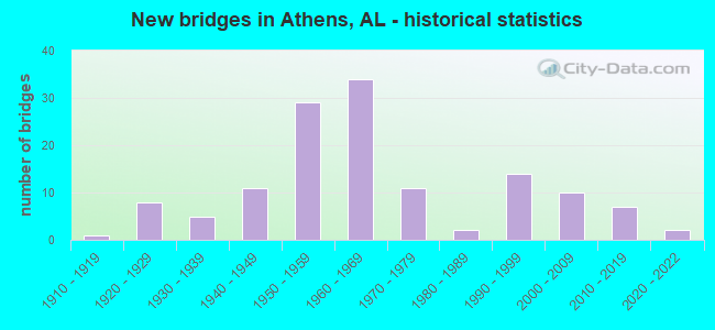
- New bridges - historical statistics
- 11910-1919
- 81920-1929
- 51930-1939
- 111940-1949
- 291950-1959
- 341960-1969
- 111970-1979
- 21980-1989
- 141990-1999
- 102000-2009
- 72010-2019
- 22020-2022
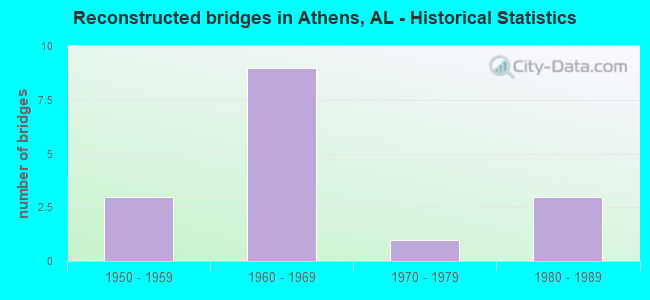
- Reconstructed bridges - Historical Statistics
- 31950-1959
- 91960-1969
- 11970-1979
- 31980-1989
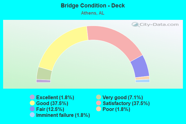
- Bridge Condition - Deck
- 1.8%Excellent
- 7.1%Very good
- 37.5%Good
- 37.5%Satisfactory
- 12.5%Fair
- 1.8%Poor
- 1.8%Imminent failure
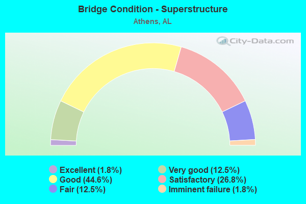
- Bridge Condition - Superstructure
- 1.8%Excellent
- 12.5%Very good
- 44.6%Good
- 26.8%Satisfactory
- 12.5%Fair
- 1.8%Imminent failure
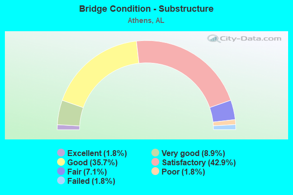
- Bridge Condition - Substructure
- 1.8%Excellent
- 8.9%Very good
- 35.7%Good
- 42.9%Satisfactory
- 7.1%Fair
- 1.8%Poor
- 1.8%Failed
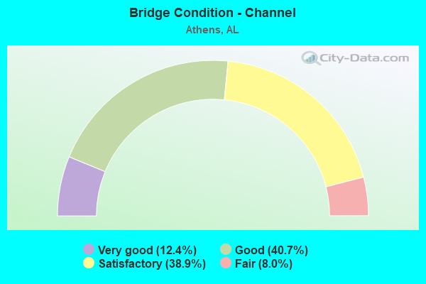
- Bridge Condition - Channel
- 12.4%Very good
- 40.7%Good
- 38.9%Satisfactory
- 8.0%Fair

- Bridge Condition - Culverts
- 11.8%Very good
- 41.2%Good
- 39.7%Satisfactory
- 7.4%Fair
Find on map >> Show street view
Structure Number: 6346, Location: S. JEFFERSON * SOUTH ST. (Lat: 34.800028, Lng: -86.972444), Route carried "on" structure: City street , Year Built: 1958, Status: Open, Structure Length: 1.83m (6.00ft), Average Daily Traffic: 6,697 (year 2003), Truck Traffic: 10%, Average Future Daily Traffic: 8,796 (year 2033), Design Load: HS 20, Features Intersected: TOWN CREEK, Facility Carried by Structure: SOUTH JEFFERSON S
Minimum Vertical Clearance: 7.56m (24.80ft), Kilometerpoint: 0.999, Lanes on structure: 4, Owner: City or Municipal Highway Agency, Approaching Roadway Width: 13.4m (44.0ft), Skew: 4 degrees, Material/Design: Concrete, Design/Construction: Culvert, Number Of Spans In Main Unit: 4, Length of Maximum Span: 3.0m (9.8ft), Curb-To-Curb Width: 13.4m (44.0ft), Out-to-Out Width: 21.4m (70.2ft)
Condition: Channel: Satisfactory, Culverts: Satisfactory, Operating Rating: 39.7 metric tons, Method Used To Determine Operating Rating: Load Factor (LF), Inventory Rating: 23.9 metric tons, Method Used To Determine Inventory Rating: Load Factor (LF), Structural Evaluation: Somewhat better than minimum adequacy, Deck Geometry: High priority of replacement, Waterway Adequacy: Better than present minimum criteria, Approach Roadway Alignment: Equal to present desirable criteria, Length Of Structure Improvement: 2.54m (8.33ft), Designated Inspection Frequency: Every 24 months, Inspection Date: Febuary 2021, Bridge Improvement Cost: $1,939,000, Roadway Improvement Cost: $194,000, Total Project Cost: $2,133,000 ( Estimate for 2022)
Find on map >> Show street view
Structure Number: 6541, Location: 0.4 M W JCT SR 2 & I 65 (Lat: 34.785050, Lng: -86.948131), Route carried "on" structure: US 72, Year Built: 1959, Status: Open, Structure Length: 6.22m (20.41ft), Average Daily Traffic: 16,400 (year 2020), Truck Traffic: 5%, Average Future Daily Traffic: 19,932 (year 2033), Design Load: HS 20, Features Intersected: SWAN CREEK, Facility Carried by Structure: SR 2
Minimum Vertical Clearance: 30+ m (98+ ft), Kilometerpoint: 122.511, Lanes on structure: 2, Base Highway Network: Yes, Owner: State Highway Agency, Approaching Roadway Width: 7.3m (24.0ft), Skew: 10 degrees, Material/Design: Concrete, Design/Construction: Tee Beam, Number Of Spans In Main Unit: 6, Length of Maximum Span: 10.4m (34.1ft), Curb or Sidewalk Widths: Left: 0.5m (1.6ft), Right: 0.5m (1.6ft), Curb-To-Curb Width: 8.5m (27.9ft), Out-to-Out Width: 10.1m (33.1ft)
Condition: Deck: Fair, Superstructure: Fair, Substructure: Satisfactory, Channel: Satisfactory, Operating Rating: 48.4 metric tons, Method Used To Determine Operating Rating: Load Factor (LF), Inventory Rating: 29.0 metric tons, Method Used To Determine Inventory Rating: Load Factor (LF), Structural Evaluation: Somewhat better than minimum adequacy, Deck Geometry: High priority of corrective action, Waterway Adequacy: Equal to present minimum criteria, Approach Roadway Alignment: Better than present minimum criteria, Length Of Structure Improvement: 7.26m (23.82ft), Designated Inspection Frequency: Every 24 months, Inspection Date: March 2020, Bridge Improvement Cost: $1,643,000, Roadway Improvement Cost: $164,000, Total Project Cost: $1,807,000 ( Estimate for 2022), Deck Structure Type: Concrete Cast-file-Place, Wearing Surface/Protective System: Wearing Surface: Bituminous, Membrane: Built-up
Find on map >> Show street view
Structure Number: 6542, Location: 1.8 MI E JCT SR 2 & I 65 (Lat: 34.773428, Lng: -86.911258), Route carried "on" structure: US 72, Year Built: 1959, Status: Open, Structure Length: 7.25m (23.79ft), Average Daily Traffic: 9,320 (year 2020), Truck Traffic: 3%, Average Future Daily Traffic: 11,327 (year 2033), Design Load: HS 20, Features Intersected: PINEY CREEK, Facility Carried by Structure: SR 2
Minimum Vertical Clearance: 30+ m (98+ ft), Kilometerpoint: 126.245, Lanes on structure: 2, Base Highway Network: Yes, Owner: State Highway Agency, Approaching Roadway Width: 12.2m (40.0ft), Skew: 10 degrees, Material/Design: Concrete, Design/Construction: Tee Beam, Number Of Spans In Main Unit: 7, Length of Maximum Span: 10.4m (34.1ft), Curb or Sidewalk Widths: Left: 0.5m (1.6ft), Right: 0.5m (1.6ft), Curb-To-Curb Width: 8.5m (27.9ft), Out-to-Out Width: 10.1m (33.1ft)
Condition: Deck: Satisfactory, Superstructure: Satisfactory, Substructure: Satisfactory, Channel: Satisfactory, Operating Rating: 48.4 metric tons, Method Used To Determine Operating Rating: Load Factor (LF), Inventory Rating: 29.0 metric tons, Method Used To Determine Inventory Rating: Load Factor (LF), Structural Evaluation: Equal to present minimum criteria, Deck Geometry: High priority of corrective action, Waterway Adequacy: Equal to present minimum criteria, Approach Roadway Alignment: Better than present minimum criteria, Length Of Structure Improvement: 8.28m (27.17ft), Designated Inspection Frequency: Every 24 months, Inspection Date: March 2020, Bridge Improvement Cost: $1,873,000, Roadway Improvement Cost: $187,000, Total Project Cost: $2,060,000 ( Estimate for 2022), Deck Structure Type: Concrete Cast-file-Place
Find on map >> Show street view
Structure Number: 6543, Location: 3.8 MI E JCT SR 2 & I 65 (Lat: 34.765000, Lng: -86.878333), Route carried "on" structure: US 72, Year Built: 1959, Status: Open, Structure Length: 3.35m (10.99ft), Average Daily Traffic: 9,320 (year 2020), Truck Traffic: 3%, Average Future Daily Traffic: 11,327 (year 2033), Design Load: HS 20, Features Intersected: FRENCH MILL CREEK, Facility Carried by Structure: SR 2
Minimum Vertical Clearance: 30+ m (98+ ft), Kilometerpoint: 129.369, Lanes on structure: 2, Base Highway Network: Yes, Owner: State Highway Agency, Approaching Roadway Width: 7.3m (24.0ft), Skew: 13 degrees, Material/Design: Concrete, Design/Construction: Culvert, Number Of Spans In Main Unit: 5, Length of Maximum Span: 4.6m (15.1ft)
Condition: Channel: Fair, Culverts: Satisfactory, Operating Rating: 45.2 metric tons, Method Used To Determine Operating Rating: Load Factor (LF), Inventory Rating: 27.0 metric tons, Method Used To Determine Inventory Rating: Load Factor (LF), Structural Evaluation: Equal to present minimum criteria, Waterway Adequacy: Equal to present minimum criteria, Approach Roadway Alignment: Better than present minimum criteria, Length Of Structure Improvement: 4.23m (13.88ft), Designated Inspection Frequency: Every 24 months, Inspection Date: March 2020, Bridge Improvement Cost: $1,418,000, Roadway Improvement Cost: $142,000, Total Project Cost: $1,560,000 ( Estimate for 2022), Wearing Surface/Protective System: Wearing Surface: Bituminous
Find on map >> Show street view
Structure Number: 6686, Location: 0.2 MI W OF US 31 (Lat: 34.803383, Lng: -86.955900), Route carried "on" structure: City street , Year Built: 1959, Status: Open, Structure Length: 1.07m (3.51ft), Average Daily Traffic: 4,708 (year 2003), Truck Traffic: 15%, Average Future Daily Traffic: 5,629 (year 2032), Design Load: H 10, Features Intersected: BRANCH, Facility Carried by Structure: HOBBS ST
Minimum Vertical Clearance: 7.56m (24.80ft), Kilometerpoint: 0.010, Lanes on structure: 4, Owner: City or Municipal Highway Agency, Approaching Roadway Width: 14.7m (48.2ft), Skew: 4 degrees, Material/Design: Concrete, Design/Construction: Culvert, Number Of Spans In Main Unit: 2, Length of Maximum Span: 5.5m (18.0ft), Curb or Sidewalk Widths: Left: 0.1m (0.3ft), Right: 1.2m (3.9ft)
Condition: Channel: Good, Culverts: Satisfactory, Operating Rating: 70.2 metric tons, Method Used To Determine Operating Rating: Load Factor (LF), Inventory Rating: 42.2 metric tons, Method Used To Determine Inventory Rating: Load Factor (LF), Structural Evaluation: Equal to present minimum criteria, Waterway Adequacy: Better than present minimum criteria, Approach Roadway Alignment: Equal to present desirable criteria, Length Of Structure Improvement: 1.74m (5.71ft), Designated Inspection Frequency: Every 24 months, Inspection Date: Febuary 2021, Bridge Improvement Cost: $1,138,000, Roadway Improvement Cost: $114,000, Total Project Cost: $1,252,000 ( Estimate for 2022), Deck Structure Type: Concrete Cast-file-Place, Wearing Surface/Protective System: Wearing Surface: Bituminous
Find on map >> Show street view
Structure Number: 7041, Location: SEC14 T3S R5W (Lat: 34.788806, Lng: -87.036514), Route carried "on" structure: County highway 47, Year Built: 1960, Status: Posted for load, Structure Length: 1.86m (6.10ft), Average Daily Traffic: 798 (year 2019), Truck Traffic: 2%, Average Future Daily Traffic: 1,234 (year 2041), Features Intersected: ROUND ISLAND, Facility Carried by Structure: REID RD
Minimum Vertical Clearance: 30+ m (98+ ft), Kilometerpoint: 0.010, Lanes on structure: 2, Owner: County Highway Agency, Approaching Roadway Width: 8.5m (27.9ft), Material/Design: Steel, Design/Construction: Stringer/Multi-beam, Number Of Spans In Main Unit: 2, Length of Maximum Span: 9.1m (29.9ft), Curb-To-Curb Width: 7.3m (24.0ft), Out-to-Out Width: 7.5m (24.6ft)
Condition: Deck: Good, Superstructure: Good, Substructure: Good, Channel: Good, Operating Rating: 22.4 metric tons, Method Used To Determine Operating Rating: Load Factor (LF), Inventory Rating: 13.4 metric tons, Method Used To Determine Inventory Rating: Load Factor (LF), Structural Evaluation: Meets minimum limits, Deck Geometry: Meets minimum limits, Waterway Adequacy: Equal to present minimum criteria, Approach Roadway Alignment: Equal to present minimum criteria, Bridge Posting: Required (Relationship of Operating Rating to Maximum Legal Load: 20.0 - 29.9% below), Length Of Structure Improvement: 2.58m (8.46ft), Designated Inspection Frequency: Every 24 months, Other Special Inspection Frequency: Every 12 months, Inspection Date: April 2020, Other Special Inspection Date: April 2021, Bridge Improvement Cost: $425,000, Roadway Improvement Cost: $43,000, Total Project Cost: $468,000 ( Estimate for 2022), Deck Structure Type: Concrete Cast-file-Place
Find on map >> Show street view
Structure Number: 7104, Location: SEC15 T2S R4W (Lat: 34.869486, Lng: -86.937125), Route carried "on" structure: County highway 82, Year Built: 1960, Status: Posted for load, Structure Length: 1.52m (4.99ft), Average Daily Traffic: 370 (year 2014), Truck Traffic: 1%, Average Future Daily Traffic: 550 (year 2034), Features Intersected: MUDDY CR, Facility Carried by Structure: CAGLE RD.
Minimum Vertical Clearance: 30+ m (98+ ft), Kilometerpoint: 0.010, Lanes on structure: 2, Owner: County Highway Agency, Approaching Roadway Width: 6.1m (20.0ft), Material/Design: Steel, Design/Construction: Stringer/Multi-beam, Number Of Spans In Main Unit: 2, Length of Maximum Span: 7.3m (24.0ft), Curb-To-Curb Width: 6.1m (20.0ft), Out-to-Out Width: 6.1m (20.0ft)
Condition: Deck: Satisfactory, Superstructure: Satisfactory, Substructure: Good, Channel: Satisfactory, Operating Rating: 23.4 metric tons, Method Used To Determine Operating Rating: Load Factor (LF), Inventory Rating: 14.1 metric tons, Method Used To Determine Inventory Rating: Load Factor (LF), Structural Evaluation: Meets minimum limits, Deck Geometry: Meets minimum limits, Waterway Adequacy: Equal to present minimum criteria, Approach Roadway Alignment: Somewhat better than minimum adequacy, Bridge Posting: Required (Relationship of Operating Rating to Maximum Legal Load: > 39.9% below), Length Of Structure Improvement: 2.20m (7.22ft), Designated Inspection Frequency: Every 24 months, Other Special Inspection Frequency: Every 12 months, Inspection Date: August 2020, Other Special Inspection Date: August 2021, Bridge Improvement Cost: $302,000, Roadway Improvement Cost: $30,000, Total Project Cost: $332,000 ( Estimate for 2022), Deck Structure Type: Corrugated Steel, Wearing Surface/Protective System: Wearing Surface: Bituminous
Find on map >> Show street view
Structure Number: 7395, Location: SEC29 T3S R5W (Lat: 34.755572, Lng: -87.089903), Route carried "on" structure: Bypass County highway 33, Year Built: 1961, Status: Open, Structure Length: 2.19m (7.19ft), Average Daily Traffic: 350 (year 2014), Truck Traffic: 1%, Average Future Daily Traffic: 500 (year 2034), Design Load: H 15, Features Intersected: DRY CR, Facility Carried by Structure: SEVEN MILE POST R
Minimum Vertical Clearance: 30+ m (98+ ft), Kilometerpoint: 0.010, Lanes on structure: 2, Owner: County Highway Agency, Approaching Roadway Width: 7.3m (24.0ft), Skew: 4 degrees, Material/Design: Concrete, Design/Construction: Culvert, Number Of Spans In Main Unit: 4, Length of Maximum Span: 5.5m (18.0ft), Curb-To-Curb Width: 6.7m (22.0ft), Out-to-Out Width: 6.7m (22.0ft)
Condition: Channel: Satisfactory, Culverts: Satisfactory, Operating Rating: 47.4 metric tons, Method Used To Determine Operating Rating: Load Factor (LF), Inventory Rating: 28.5 metric tons, Method Used To Determine Inventory Rating: Load Factor (LF), Structural Evaluation: Equal to present minimum criteria, Deck Geometry: Meets minimum limits, Waterway Adequacy: Equal to present minimum criteria, Approach Roadway Alignment: Equal to present minimum criteria, Length Of Structure Improvement: 3.00m (9.84ft), Designated Inspection Frequency: Every 24 months, Inspection Date: Febuary 2022, Bridge Improvement Cost: $813,000, Roadway Improvement Cost: $81,000, Total Project Cost: $894,000 ( Estimate for 2022)
Find on map >> Show street view
Structure Number: 7718, Location: SEC7 T3S R3W (Lat: 34.788528, Lng: -86.890361), Route carried "on" structure: City street , Year Built: 1962, Status: Posted for load, Structure Length: 7.25m (23.79ft), Average Daily Traffic: 1,066 (year 2006), Truck Traffic: 1%, Average Future Daily Traffic: 1,234 (year 2035), Design Load: H 15, Features Intersected: PINEY CR, Facility Carried by Structure: PEPPER RD
Minimum Vertical Clearance: 30+ m (98+ ft), Kilometerpoint: 0.010, Lanes on structure: 2, Owner: City or Municipal Highway Agency, Approaching Roadway Width: 6.1m (20.0ft), Skew: 3 degrees, Material/Design: Concrete, Design/Construction: Tee Beam, Number Of Spans In Main Unit: 7, Length of Maximum Span: 10.4m (34.1ft), Curb or Sidewalk Widths: Left: 0.2m (0.7ft), Right: 0.2m (0.7ft), Curb-To-Curb Width: 6.6m (21.7ft), Out-to-Out Width: 7.2m (23.6ft)
Condition: Deck: Satisfactory, Superstructure: Good, Substructure: Satisfactory, Channel: Satisfactory, Operating Rating: 34.7 metric tons, Method Used To Determine Operating Rating: Load Factor (LF), Inventory Rating: 20.9 metric tons, Method Used To Determine Inventory Rating: Load Factor (LF), Structural Evaluation: Somewhat better than minimum adequacy, Deck Geometry: High priority of replacement, Waterway Adequacy: Equal to present minimum criteria, Approach Roadway Alignment: Equal to present minimum criteria, Bridge Posting: Required (Relationship of Operating Rating to Maximum Legal Load: 0.1 - 9.9% below), Length Of Structure Improvement: 8.28m (27.17ft), Designated Inspection Frequency: Every 24 months, Other Special Inspection Frequency: Every 12 months, Inspection Date: Febuary 2022, Other Special Inspection Date: Febuary 2022, Bridge Improvement Cost: $1,306,000, Roadway Improvement Cost: $131,000, Total Project Cost: $1,437,000 ( Estimate for 2022), Deck Structure Type: Concrete Cast-file-Place
Find on map >> Show street view
Structure Number: 7782, Location: SEC4 T3S R3W (Lat: 34.808175, Lng: -86.859128), Route carried "on" structure: County highway 95, Year Built: 1962, Status: Open, Structure Length: 1.17m (3.84ft), Average Daily Traffic: 490 (year 2014), Truck Traffic: 1%, Average Future Daily Traffic: 720 (year 2034), Design Load: H 15, Features Intersected: JOHNSON BR, Facility Carried by Structure: MEADOWS RD
Minimum Vertical Clearance: 30+ m (98+ ft), Kilometerpoint: 0.010, Lanes on structure: 2, Owner: County Highway Agency, Approaching Roadway Width: 8.5m (27.9ft), Material/Design: Concrete, Design/Construction: Culvert, Number Of Spans In Main Unit: 3, Length of Maximum Span: 3.7m (12.1ft), Curb-To-Curb Width: 9.9m (32.5ft), Out-to-Out Width: 10.4m (34.1ft)
Condition: Channel: Satisfactory, Culverts: Good, Operating Rating: 44.4 metric tons, Method Used To Determine Operating Rating: Load Factor (LF), Inventory Rating: 26.6 metric tons, Method Used To Determine Inventory Rating: Load Factor (LF), Structural Evaluation: Equal to present minimum criteria, Deck Geometry: Equal to present minimum criteria, Waterway Adequacy: Equal to present minimum criteria, Approach Roadway Alignment: Equal to present desirable criteria, Length Of Structure Improvement: 1.85m (6.07ft), Designated Inspection Frequency: Every 24 months, Inspection Date: December 2020, Bridge Improvement Cost: $342,000, Roadway Improvement Cost: $34,000, Total Project Cost: $376,000 ( Estimate for 2022)
Find on map >> Show street view
Structure Number: 8188, Location: 2.5 MI N JCT I 65 & SR 3 (Lat: 34.860000, Lng: -86.926667), Route carried "on" structure: County highway 86, Year Built: 1964, Status: Open, Structure Length: 9.75m (31.99ft), Average Daily Traffic: 1,576 (year 2020), Truck Traffic: 1%, Average Future Daily Traffic: 2,411 (year 2042), Design Load: H 20, Features Intersected: I 65, Facility Carried by Structure: BLACK RD
Minimum Vertical Clearance: 30+ m (98+ ft), Kilometerpoint: 0.000, Lanes on structure: 2, Lanes under structure: 8, Owner: State Highway Agency, Approaching Roadway Width: 9.8m (32.2ft), Skew: 3 degrees, Material/Design: Concrete continuous, Design/Construction: Tee Beam, Number Of Spans In Main Unit: 4, Number Of Approach Spans: 1, Length of Maximum Span: 23.8m (78.1ft), Curb or Sidewalk Widths: Left: 0.5m (1.6ft), Right: 0.5m (1.6ft), Curb-To-Curb Width: 7.3m (24.0ft), Out-to-Out Width: 8.8m (28.9ft)
Condition: Deck: Satisfactory, Superstructure: Satisfactory, Substructure: Satisfactory, Operating Rating: 42.3 metric tons, Method Used To Determine Operating Rating: Load Factor (LF), Inventory Rating: 25.3 metric tons, Method Used To Determine Inventory Rating: Load Factor (LF), Structural Evaluation: Equal to present minimum criteria, Deck Geometry: Meets minimum limits, Underclear: Meets minimum limits, Approach Roadway Alignment: Equal to present minimum criteria, Length Of Structure Improvement: 10.69m (35.07ft), Designated Inspection Frequency: Every 24 months, Inspection Date: March 2020, Bridge Improvement Cost: $2,127,000, Roadway Improvement Cost: $213,000, Total Project Cost: $2,340,000 ( Estimate for 2022), Deck Structure Type: Concrete Cast-file-Place
Find on map >> Show street view
Structure Number: 8237, Location: 3 MI N JCT SR 3 & SR 2 (Lat: 34.827667, Lng: -86.939472), Route carried "on" structure: US 31, Year Built: 1964, Status: Open, Structure Length: 10.67m (35.01ft), Average Daily Traffic: 3,135 (year 2021), Truck Traffic: 6%, Average Future Daily Traffic: 4,027 (year 2033), Design Load: HS 20, Features Intersected: I 65, Facility Carried by Structure: SR 3
Minimum Vertical Clearance: 30+ m (98+ ft), Kilometerpoint: 602.501, Lanes on structure: 1, Lanes under structure: 4, Base Highway Network: Yes, Owner: State Highway Agency, Approaching Roadway Width: 11.0m (36.1ft), Skew: 4 degrees, Material/Design: Concrete continuous, Design/Construction: Tee Beam, Number Of Spans In Main Unit: 4, Length of Maximum Span: 29.3m (96.1ft), Curb or Sidewalk Widths: Left: 0.5m (1.6ft), Right: 0.5m (1.6ft), Curb-To-Curb Width: 6.1m (20.0ft), Out-to-Out Width: 7.7m (25.3ft)
Condition: Deck: Satisfactory, Superstructure: Satisfactory, Substructure: Good, Operating Rating: 54.2 metric tons, Method Used To Determine Operating Rating: Load Factor (LF), Inventory Rating: 33.4 metric tons, Method Used To Determine Inventory Rating: Load Factor (LF), Structural Evaluation: Equal to present minimum criteria, Deck Geometry: High priority of replacement, Underclear: Equal to present minimum criteria, Approach Roadway Alignment: Better than present minimum criteria, Length Of Structure Improvement: 11.57m (37.96ft), Designated Inspection Frequency: Every 24 months, Inspection Date: June 2021, Bridge Improvement Cost: $1,983,000, Roadway Improvement Cost: $198,000, Total Project Cost: $2,181,000 ( Estimate for 2022), Deck Structure Type: Concrete Cast-file-Place
Find on map >> Show street view
Structure Number: 8499, Location: 5.9 MI W JCT SR 2 & SR 3 (Lat: 34.791667, Lng: -87.058333), Route carried "on" structure: US 72, Year Built: 1924, Year Reconstructed: 1965, Status: Open, Structure Length: 0.76m (2.49ft), Average Daily Traffic: 11,200 (year 2022), Truck Traffic: 9%, Average Future Daily Traffic: 13,612 (year 2033), Design Load: H 15, Features Intersected: BRANCH, Facility Carried by Structure: SR 2
Minimum Vertical Clearance: 30+ m (98+ ft), Kilometerpoint: 112.426, Lanes on structure: 4, Base Highway Network: Yes, Owner: State Highway Agency, Approaching Roadway Width: 14.6m (47.9ft), Material/Design: Concrete, Design/Construction: Culvert, Number Of Spans In Main Unit: 3, Length of Maximum Span: 2.4m (7.9ft)
Condition: Channel: Satisfactory, Culverts: Satisfactory, Operating Rating: 48.1 metric tons, Method Used To Determine Operating Rating: Load Factor (LF), Inventory Rating: 28.8 metric tons, Method Used To Determine Inventory Rating: Load Factor (LF), Structural Evaluation: Equal to present minimum criteria, Waterway Adequacy: Equal to present minimum criteria, Approach Roadway Alignment: Better than present minimum criteria, Length Of Structure Improvement: 1.41m (4.63ft), Designated Inspection Frequency: Every 24 months, Inspection Date: Febuary 2022, Bridge Improvement Cost: $642,000, Roadway Improvement Cost: $64,000, Total Project Cost: $706,000 ( Estimate for 2022), Wearing Surface/Protective System: Wearing Surface: Bituminous
Find on map >> Show street view
Structure Number: 8508, Location: 3.1 MI W JCT SR 2 & SR 3 (Lat: 34.791667, Lng: -87.053333), Route carried "on" structure: US 72, Year Built: 1934, Year Reconstructed: 1965, Status: Open, Structure Length: 0.76m (2.49ft), Average Daily Traffic: 11,200 (year 2020), Truck Traffic: 9%, Average Future Daily Traffic: 13,612 (year 2033), Design Load: H 15, Features Intersected: BRANCH, Facility Carried by Structure: SR 2
Minimum Vertical Clearance: 30+ m (98+ ft), Kilometerpoint: 112.780, Lanes on structure: 5, Base Highway Network: Yes, Owner: State Highway Agency, Approaching Roadway Width: 14.6m (47.9ft), Material/Design: Concrete, Design/Construction: Culvert, Number Of Spans In Main Unit: 3, Length of Maximum Span: 2.4m (7.9ft)
Condition: Channel: Good, Culverts: Good, Operating Rating: 37.2 metric tons, Method Used To Determine Operating Rating: Load Factor (LF), Inventory Rating: 22.3 metric tons, Method Used To Determine Inventory Rating: Load Factor (LF), Structural Evaluation: Somewhat better than minimum adequacy, Waterway Adequacy: Better than present minimum criteria, Approach Roadway Alignment: Better than present minimum criteria, Length Of Structure Improvement: 1.41m (4.63ft), Designated Inspection Frequency: Every 24 months, Inspection Date: March 2022, Bridge Improvement Cost: $602,000, Roadway Improvement Cost: $60,000, Total Project Cost: $662,000 ( Estimate for 2022), Wearing Surface/Protective System: Wearing Surface: Bituminous
Find on map >> Show street view
Structure Number: 8509, Location: 4.3 MI W JCT SR 2 & SR 3 (Lat: 34.791258, Lng: -87.032622), Route carried "on" structure: US 72, Year Built: 1934, Year Reconstructed: 1965, Status: Open, Structure Length: 1.71m (5.61ft), Average Daily Traffic: 14,840 (year 2022), Truck Traffic: 8%, Average Future Daily Traffic: 18,036 (year 2033), Design Load: H 15, Features Intersected: ROUND ISLAND CREEK, Facility Carried by Structure: SR 2
Minimum Vertical Clearance: 30+ m (98+ ft), Kilometerpoint: 114.600, Lanes on structure: 4, Base Highway Network: Yes, Owner: State Highway Agency, Approaching Roadway Width: 14.6m (47.9ft), Material/Design: Steel continuous, Design/Construction: Stringer/Multi-beam, Number Of Spans In Main Unit: 3, Length of Maximum Span: 5.8m (19.0ft), Curb or Sidewalk Widths: Left: 0.4m (1.3ft), Right: 0.4m (1.3ft), Curb-To-Curb Width: 17.3m (56.8ft), Out-to-Out Width: 18.0m (59.1ft)
Condition: Deck: Satisfactory, Superstructure: Satisfactory, Substructure: Satisfactory, Channel: Satisfactory, Operating Rating: 32.7 metric tons, Method Used To Determine Operating Rating: Field evaluation and documented engineering judgment, Inventory Rating: 23.6 metric tons, Method Used To Determine Inventory Rating: Field evaluation and documented engineering judgment, Structural Evaluation: Somewhat better than minimum adequacy, Deck Geometry: Somewhat better than minimum adequacy, Waterway Adequacy: Better than present minimum criteria, Approach Roadway Alignment: Equal to present minimum criteria, Length Of Structure Improvement: 2.41m (7.91ft), Designated Inspection Frequency: Every 24 months, Inspection Date: March 2022, Bridge Improvement Cost: $974,000, Roadway Improvement Cost: $97,000, Total Project Cost: $1,071,000 ( Estimate for 2022), Deck Structure Type: Concrete Cast-file-Place, Wearing Surface/Protective System: Wearing Surface: Bituminous
Find on map >> Show street view
Structure Number: 851, Location: 4.6 M W JCT SR 2 & SR 3 (Lat: 34.791200, Lng: -87.026100), Route carried "on" structure: State highway 72, Year Built: 1934, Year Reconstructed: 1965, Status: Open, Structure Length: 0.94m (3.08ft), Average Daily Traffic: 14,840 (year 2020), Truck Traffic: 8%, Average Future Daily Traffic: 18,036 (year 2033), Design Load: H 15, Features Intersected: BRANCH, Facility Carried by Structure: SR 2
Minimum Vertical Clearance: 30+ m (98+ ft), Kilometerpoint: 115.147, Lanes on structure: 4, Owner: State Highway Agency, Approaching Roadway Width: 14.6m (47.9ft), Skew: 4 degrees, Material/Design: Concrete, Design/Construction: Culvert, Number Of Spans In Main Unit: 2, Length of Maximum Span: 3.0m (9.8ft)
Condition: Channel: Satisfactory, Culverts: Satisfactory, Operating Rating: 33.8 metric tons, Method Used To Determine Operating Rating: Load Factor (LF), Inventory Rating: 20.2 metric tons, Method Used To Determine Inventory Rating: Load Factor (LF), Structural Evaluation: Somewhat better than minimum adequacy, Waterway Adequacy: Equal to present minimum criteria, Approach Roadway Alignment: Better than present minimum criteria, Length Of Structure Improvement: 1.61m (5.28ft), Designated Inspection Frequency: Every 24 months, Inspection Date: March 2022, Bridge Improvement Cost: $650,000, Roadway Improvement Cost: $65,000, Total Project Cost: $715,000 ( Estimate for 2022), Wearing Surface/Protective System: Wearing Surface: Bituminous
Find on map >> Show street view
Structure Number: 8752, Location: SEC26 T3S R5W (Lat: 34.747422, Lng: -87.021228), Route carried "on" structure: County highway 30, Year Built: 1965, Status: Open, Structure Length: 0.98m (3.22ft), Average Daily Traffic: 500 (year 2014), Truck Traffic: 2%, Average Future Daily Traffic: 750 (year 2034), Design Load: H 15, Features Intersected: LAKE CR, Facility Carried by Structure: MALONE RD
Minimum Vertical Clearance: 30+ m (98+ ft), Kilometerpoint: 0.010, Lanes on structure: 2, Owner: County Highway Agency, Approaching Roadway Width: 8.5m (27.9ft), Material/Design: Concrete, Design/Construction: Culvert, Number Of Spans In Main Unit: 3, Length of Maximum Span: 3.0m (9.8ft), Curb-To-Curb Width: 9.9m (32.5ft), Out-to-Out Width: 10.4m (34.1ft)
Condition: Channel: Satisfactory, Culverts: Good, Operating Rating: 37.8 metric tons, Method Used To Determine Operating Rating: Load Factor (LF), Inventory Rating: 22.7 metric tons, Method Used To Determine Inventory Rating: Load Factor (LF), Structural Evaluation: Equal to present minimum criteria, Deck Geometry: Equal to present minimum criteria, Waterway Adequacy: Better than present minimum criteria, Approach Roadway Alignment: Better than present minimum criteria, Length Of Structure Improvement: 1.65m (5.41ft), Designated Inspection Frequency: Every 24 months, Inspection Date: March 2020, Bridge Improvement Cost: $325,000, Roadway Improvement Cost: $33,000, Total Project Cost: $358,000 ( Estimate for 2022)
Find on map >> Show street view
Structure Number: 8753, Location: 2.4 MI W US 31 (Lat: 34.746972, Lng: -86.999750), Route carried "on" structure: City street 30, Year Built: 1965, Status: Open, Structure Length: 0.98m (3.22ft), Average Daily Traffic: 460 (year 2002), Truck Traffic: 1%, Average Future Daily Traffic: 680 (year 2033), Design Load: H 15, Features Intersected: BRANCH, Facility Carried by Structure: MOYERS RD
Minimum Vertical Clearance: 30+ m (98+ ft), Kilometerpoint: 0.016, Lanes on structure: 2, Owner: City or Municipal Highway Agency, Approaching Roadway Width: 8.5m (27.9ft), Material/Design: Concrete, Design/Construction: Culvert, Number Of Spans In Main Unit: 3, Length of Maximum Span: 3.0m (9.8ft), Curb-To-Curb Width: 10.5m (34.4ft), Out-to-Out Width: 11.0m (36.1ft)
Condition: Channel: Good, Culverts: Satisfactory, Operating Rating: 34.7 metric tons, Method Used To Determine Operating Rating: Load Factor (LF), Inventory Rating: 20.9 metric tons, Method Used To Determine Inventory Rating: Load Factor (LF), Structural Evaluation: Equal to present minimum criteria, Deck Geometry: Equal to present minimum criteria, Waterway Adequacy: Equal to present minimum criteria, Approach Roadway Alignment: Better than present minimum criteria, Length Of Structure Improvement: 1.65m (5.41ft), Designated Inspection Frequency: Every 24 months, Inspection Date: Febuary 2021, Bridge Improvement Cost: $344,000, Roadway Improvement Cost: $34,000, Total Project Cost: $378,000 ( Estimate for 2022)
Find on map >> Show street view
Structure Number: 8754, Location: SEC26 T3S R5W (Lat: 34.747547, Lng: -87.028947), Route carried "on" structure: County highway 30, Year Built: 1965, Status: Open, Structure Length: 0.67m (2.20ft), Average Daily Traffic: 500 (year 2014), Truck Traffic: 2%, Average Future Daily Traffic: 740 (year 2034), Design Load: H 15, Features Intersected: BRANCH, Facility Carried by Structure: MALONE RD
Minimum Vertical Clearance: 30+ m (98+ ft), Kilometerpoint: 0.010, Lanes on structure: 2, Owner: County Highway Agency, Approaching Roadway Width: 8.5m (27.9ft), Material/Design: Concrete, Design/Construction: Culvert, Number Of Spans In Main Unit: 2, Length of Maximum Span: 3.0m (9.8ft), Curb-To-Curb Width: 10.5m (34.4ft), Out-to-Out Width: 11.0m (36.1ft)
Condition: Channel: Satisfactory, Culverts: Good, Operating Rating: 43.4 metric tons, Method Used To Determine Operating Rating: Load Factor (LF), Inventory Rating: 26.0 metric tons, Method Used To Determine Inventory Rating: Load Factor (LF), Structural Evaluation: Equal to present minimum criteria, Deck Geometry: Equal to present minimum criteria, Waterway Adequacy: Better than present minimum criteria, Approach Roadway Alignment: Better than present minimum criteria, Length Of Structure Improvement: 1.30m (4.27ft), Designated Inspection Frequency: Every 24 months, Inspection Date: March 2020, Bridge Improvement Cost: $270,000, Roadway Improvement Cost: $27,000, Total Project Cost: $297,000 ( Estimate for 2022)
Find on map >> Show street view
Structure Number: 8783, Location: SEC21 T2S R5W (Lat: 34.851406, Lng: -87.053439), Route carried "on" structure: County highway 43, Year Built: 1965, Status: Open, Structure Length: 1.83m (6.00ft), Average Daily Traffic: 940 (year 2009), Truck Traffic: 5%, Average Future Daily Traffic: 1,400 (year 2029), Design Load: H 15, Features Intersected: BIG CR, Facility Carried by Structure: TILLMAN MILL RD
Minimum Vertical Clearance: 30+ m (98+ ft), Kilometerpoint: 0.010, Lanes on structure: 2, Owner: County Highway Agency, Approaching Roadway Width: 8.5m (27.9ft), Skew: 4 degrees, Material/Design: Concrete, Design/Construction: Culvert, Number Of Spans In Main Unit: 4, Length of Maximum Span: 3.7m (12.1ft), Curb-To-Curb Width: 8.5m (27.9ft), Out-to-Out Width: 8.5m (27.9ft)
Condition: Channel: Good, Culverts: Satisfactory, Operating Rating: 55.3 metric tons, Method Used To Determine Operating Rating: Load Factor (LF), Inventory Rating: 33.2 metric tons, Method Used To Determine Inventory Rating: Load Factor (LF), Structural Evaluation: Equal to present minimum criteria, Deck Geometry: Somewhat better than minimum adequacy, Waterway Adequacy: Better than present minimum criteria, Approach Roadway Alignment: Equal to present desirable criteria, Length Of Structure Improvement: 2.54m (8.33ft), Designated Inspection Frequency: Every 24 months, Inspection Date: March 2021, Bridge Improvement Cost: $808,000, Roadway Improvement Cost: $81,000, Total Project Cost: $889,000 ( Estimate for 2022)
Find on map >> Show street view
Structure Number: 885, Location: 0.7 M W JCT SR 99 & SR 3 (Lat: 34.819100, Lng: -86.956200), Route carried "on" structure: State highway 99, Year Built: 1965, Status: Open, Structure Length: 0.64m (2.10ft), Average Daily Traffic: 10,640 (year 2020), Truck Traffic: 3%, Average Future Daily Traffic: 14,331 (year 2033), Design Load: H 15, Features Intersected: BRANCH
Minimum Vertical Clearance: 30+ m (98+ ft), Kilometerpoint: 1.226, Lanes on structure: 4, Owner: State Highway Agency, Approaching Roadway Width: 18.9m (62.0ft), Material/Design: Concrete, Design/Construction: Culvert, Number Of Spans In Main Unit: 2, Length of Maximum Span: 3.0m (9.8ft)
Condition: Channel: Good, Culverts: Good, Operating Rating: 33.7 metric tons, Method Used To Determine Operating Rating: Load Factor (LF), Inventory Rating: 20.2 metric tons, Method Used To Determine Inventory Rating: Load Factor (LF), Structural Evaluation: Somewhat better than minimum adequacy, Waterway Adequacy: Better than present minimum criteria, Approach Roadway Alignment: Equal to present desirable criteria, Length Of Structure Improvement: 1.26m (4.13ft), Designated Inspection Frequency: Every 24 months, Inspection Date: June 2020, Bridge Improvement Cost: $575,000, Roadway Improvement Cost: $58,000, Total Project Cost: $633,000 ( Estimate for 2022), Wearing Surface/Protective System: Wearing Surface: Bituminous
Find on map >> Show street view
Structure Number: 8851, Location: 2 MI W JCT SR 99 & SR 3 (Lat: 34.819806, Lng: -86.979000), Route carried "on" structure: State highway 99, Year Built: 1965, Status: Open, Structure Length: 1.13m (3.71ft), Average Daily Traffic: 6,880 (year 2020), Truck Traffic: 3%, Average Future Daily Traffic: 9,266 (year 2033), Design Load: H 15, Features Intersected: BRANCH
Minimum Vertical Clearance: 30+ m (98+ ft), Kilometerpoint: 3.040, Lanes on structure: 2, Owner: State Highway Agency, Approaching Roadway Width: 13.7m (44.9ft), Material/Design: Concrete, Design/Construction: Culvert, Number Of Spans In Main Unit: 3, Length of Maximum Span: 3.7m (12.1ft)
Condition: Channel: Good, Culverts: Satisfactory, Operating Rating: 41.1 metric tons, Method Used To Determine Operating Rating: Load Factor (LF), Inventory Rating: 24.7 metric tons, Method Used To Determine Inventory Rating: Load Factor (LF), Structural Evaluation: Equal to present minimum criteria, Waterway Adequacy: Equal to present desirable criteria, Approach Roadway Alignment: Equal to present desirable criteria, Length Of Structure Improvement: 1.80m (5.91ft), Designated Inspection Frequency: Every 24 months, Inspection Date: June 2020, Bridge Improvement Cost: $561,000, Roadway Improvement Cost: $56,000, Total Project Cost: $617,000 ( Estimate for 2022), Wearing Surface/Protective System: Wearing Surface: Bituminous
Find on map >> Show street view
Structure Number: 8955, Location: SEC34 T3S R4W (Lat: 34.730989, Lng: -86.947747), Route carried "on" structure: County highway 24, Year Built: 1942, Year Reconstructed: 1966, Status: Open, Structure Length: 1.37m (4.49ft), Average Daily Traffic: 2,250 (year 2014), Truck Traffic: 3%, Average Future Daily Traffic: 3,375 (year 2034), Design Load: H 15, Features Intersected: OLD SCHOOL HOUSE BR, Facility Carried by Structure: HSV-BRFERRY RD
Minimum Vertical Clearance: 30+ m (98+ ft), Kilometerpoint: 0.010, Lanes on structure: 2, Owner: County Highway Agency, Approaching Roadway Width: 8.5m (27.9ft), Material/Design: Concrete, Design/Construction: Culvert, Number Of Spans In Main Unit: 5, Length of Maximum Span: 2.4m (7.9ft), Curb-To-Curb Width: 10.5m (34.4ft), Out-to-Out Width: 11.0m (36.1ft)
Condition: Channel: Satisfactory, Culverts: Fair, Operating Rating: 43.5 metric tons, Method Used To Determine Operating Rating: Field evaluation and documented engineering judgment, Inventory Rating: 32.7 metric tons, Method Used To Determine Inventory Rating: Field evaluation and documented engineering judgment, Structural Evaluation: Somewhat better than minimum adequacy, Deck Geometry: Somewhat better than minimum adequacy, Waterway Adequacy: Equal to present minimum criteria, Approach Roadway Alignment: Better than present minimum criteria, Length Of Structure Improvement: 2.04m (6.69ft), Designated Inspection Frequency: Every 24 months, Inspection Date: Febuary 2022, Bridge Improvement Cost: $425,000, Roadway Improvement Cost: $43,000, Total Project Cost: $468,000 ( Estimate for 2022)
Find on map >> Show street view
Structure Number: 9088, Location: SEC32 T3S R4W (Lat: 34.731414, Lng: -86.971097), Route carried "on" structure: County highway 24, Year Built: 1966, Status: Open, Structure Length: 4.72m (15.49ft), Average Daily Traffic: 4,540 (year 2014), Truck Traffic: 3%, Average Future Daily Traffic: 6,000 (year 2034), Design Load: H 20, Features Intersected: CSX RAILROAD, Facility Carried by Structure: HSV-BRFERRY RD
Minimum Vertical Clearance: 30+ m (98+ ft), Kilometerpoint: 0.010, Lanes on structure: 2, Owner: County Highway Agency, Approaching Roadway Width: 11.0m (36.1ft), Material/Design: Steel, Design/Construction: Stringer/Multi-beam, Number Of Spans In Main Unit: 3, Length of Maximum Span: 15.8m (51.8ft), Curb or Sidewalk Widths: Left: 1.5m (4.9ft), Right: 0.0m, Curb-To-Curb Width: 7.3m (24.0ft), Out-to-Out Width: 10.0m (32.8ft)
Condition: Deck: Good, Superstructure: Good, Substructure: Good, Operating Rating: 51.7 metric tons, Method Used To Determine Operating Rating: Allowable Stress (AS), Inventory Rating: 45.4 metric tons, Method Used To Determine Inventory Rating: Allowable Stress (AS), Structural Evaluation: Better than present minimum criteria, Deck Geometry: High priority of replacement, Approach Roadway Alignment: Better than present minimum criteria, Length Of Structure Improvement: 5.73m (18.80ft), Designated Inspection Frequency: Every 24 months, Inspection Date: October 2020, Bridge Improvement Cost: $1,256,000, Roadway Improvement Cost: $126,000, Total Project Cost: $1,382,000 ( Estimate for 2022), Deck Structure Type: Concrete Cast-file-Place
Find on map >> Show street view
Structure Number: 9335, Location: SEC18 T4S R4W (Lat: 34.688417, Lng: -86.996539), Route carried "on" structure: County highway 14, Year Built: 1967, Status: Open, Structure Length: 1.31m (4.30ft), Average Daily Traffic: 1,500 (year 2014), Truck Traffic: 9%, Average Future Daily Traffic: 2,122 (year 2034), Design Load: H 15, Features Intersected: SPRING CR, Facility Carried by Structure: HARRIS STATION RD
Minimum Vertical Clearance: 30+ m (98+ ft), Kilometerpoint: 0.010, Lanes on structure: 2, Owner: County Highway Agency, Approaching Roadway Width: 8.5m (27.9ft), Material/Design: Concrete, Design/Construction: Culvert, Number Of Spans In Main Unit: 4, Length of Maximum Span: 3.0m (9.8ft), Curb-To-Curb Width: 10.1m (33.1ft), Out-to-Out Width: 10.1m (33.1ft)
Condition: Channel: Satisfactory, Culverts: Good, Operating Rating: 44.3 metric tons, Method Used To Determine Operating Rating: Load Factor (LF), Inventory Rating: 26.5 metric tons, Method Used To Determine Inventory Rating: Load Factor (LF), Structural Evaluation: Equal to present minimum criteria, Deck Geometry: Somewhat better than minimum adequacy, Waterway Adequacy: Equal to present minimum criteria, Approach Roadway Alignment: Equal to present minimum criteria, Length Of Structure Improvement: 1.98m (6.50ft), Designated Inspection Frequency: Every 24 months, Inspection Date: Febuary 2022, Bridge Improvement Cost: $390,000, Roadway Improvement Cost: $39,000, Total Project Cost: $429,000 ( Estimate for 2022)
Find on map >> Show street view
Structure Number: 938, Location: SEC36 T2S R5W (Lat: 34.820297, Lng: -87.010122), Route carried "on" structure: County highway 48, Year Built: 1967, Status: Open, Structure Length: 1.37m (4.49ft), Average Daily Traffic: 2,200 (year 2014), Truck Traffic: 1%, Average Future Daily Traffic: 3,300 (year 2034), Design Load: H 15, Features Intersected: ROUND ISLAND CR, Facility Carried by Structure: NEW CUT RD
Minimum Vertical Clearance: 30+ m (98+ ft), Kilometerpoint: 0.010, Lanes on structure: 2, Owner: County Highway Agency, Approaching Roadway Width: 8.5m (27.9ft), Skew: 4 degrees, Material/Design: Concrete, Design/Construction: Culvert, Number Of Spans In Main Unit: 3, Length of Maximum Span: 3.0m (9.8ft), Curb-To-Curb Width: 10.1m (33.1ft), Out-to-Out Width: 11.2m (36.7ft)
Condition: Channel: Good, Culverts: Fair, Operating Rating: 82.9 metric tons, Method Used To Determine Operating Rating: Load Factor (LF), Inventory Rating: 49.7 metric tons, Method Used To Determine Inventory Rating: Load Factor (LF), Structural Evaluation: Somewhat better than minimum adequacy, Deck Geometry: Meets minimum limits, Waterway Adequacy: Equal to present minimum criteria, Approach Roadway Alignment: Equal to present desirable criteria, Length Of Structure Improvement: 2.04m (6.69ft), Designated Inspection Frequency: Every 24 months, Inspection Date: September 2020, Bridge Improvement Cost: $601,000, Roadway Improvement Cost: $60,000, Total Project Cost: $661,000 ( Estimate for 2022)
Find on map >> Show street view
Structure Number: 9396, Location: 1.5 MI W US 31 (Lat: 34.751972, Lng: -86.983750), Route carried "on" structure: City street 61, Year Built: 1967, Status: Open, Structure Length: 0.79m (2.59ft), Average Daily Traffic: 647 (year 2007), Truck Traffic: 5%, Average Future Daily Traffic: 913 (year 2033), Design Load: H 15, Features Intersected: MUD CR
Minimum Vertical Clearance: 30+ m (98+ ft), Kilometerpoint: 0.966, Lanes on structure: 2, Owner: City or Municipal Highway Agency, Approaching Roadway Width: 6.0m (19.7ft), Material/Design: Concrete, Design/Construction: Culvert, Number Of Spans In Main Unit: 2, Length of Maximum Span: 3.7m (12.1ft), Out-to-Out Width: 11.0m (36.1ft)
Condition: Channel: Satisfactory, Culverts: Satisfactory, Operating Rating: 53.4 metric tons, Method Used To Determine Operating Rating: Load Factor (LF), Inventory Rating: 32.0 metric tons, Method Used To Determine Inventory Rating: Load Factor (LF), Structural Evaluation: Equal to present minimum criteria, Waterway Adequacy: Equal to present minimum criteria, Approach Roadway Alignment: Better than present minimum criteria, Length Of Structure Improvement: 1.44m (4.72ft), Designated Inspection Frequency: Every 24 months, Inspection Date: Febuary 2021, Bridge Improvement Cost: $300,000, Roadway Improvement Cost: $30,000, Total Project Cost: $330,000 ( Estimate for 2022)
Find on map >> Show street view
Structure Number: 948, Location: 0.1 M S JCT SR251 & I 65 (Lat: 34.810303, Lng: -86.941872), Route carried "on" structure: State highway 251, Year Built: 1926, Year Reconstructed: 1968, Status: Open, Structure Length: 5.67m (18.60ft), Average Daily Traffic: 7,620 (year 2020), Truck Traffic: 3%, Average Future Daily Traffic: 8,629 (year 2033), Design Load: H 20, Features Intersected: SWAN CREEK
Minimum Vertical Clearance: 30+ m (98+ ft), Kilometerpoint: 0.837, Lanes on structure: 2, Owner: State Highway Agency, Approaching Roadway Width: 9.8m (32.2ft), Material/Design: Concrete, Design/Construction: Tee Beam, Number Of Spans In Main Unit: 7, Length of Maximum Span: 8.2m (26.9ft), Curb or Sidewalk Widths: Left: 0.5m (1.6ft), Right: 0.5m (1.6ft), Curb-To-Curb Width: 8.5m (27.9ft), Out-to-Out Width: 10.1m (33.1ft)
Condition: Deck: Fair, Superstructure: Satisfactory, Substructure: Fair, Channel: Good, Operating Rating: 76.7 metric tons, Method Used To Determine Operating Rating: Load Factor (LF), Inventory Rating: 45.9 metric tons, Method Used To Determine Inventory Rating: Load Factor (LF), Structural Evaluation: Somewhat better than minimum adequacy, Deck Geometry: High priority of replacement, Waterway Adequacy: Equal to present minimum criteria, Approach Roadway Alignment: Equal to present minimum criteria, Length Of Structure Improvement: 6.70m (21.98ft), Designated Inspection Frequency: Every 24 months, Inspection Date: July 2020, Bridge Improvement Cost: $1,517,000, Roadway Improvement Cost: $152,000, Total Project Cost: $1,669,000 ( Estimate for 2022), Deck Structure Type: Concrete Cast-file-Place, Wearing Surface/Protective System: Wearing Surface: Bituminous
Find on map >> Show street view
Structure Number: 9481, Location: 2.9 M N JCT SR251 & I 65 (Lat: 34.828800, Lng: -86.895100), Route carried "on" structure: State highway 251, Year Built: 1926, Year Reconstructed: 1968, Status: Open, Structure Length: 6.49m (21.29ft), Average Daily Traffic: 5,510 (year 2020), Truck Traffic: 5%, Average Future Daily Traffic: 6,513 (year 2033), Design Load: H 20, Features Intersected: PINEY CREEK
Minimum Vertical Clearance: 30+ m (98+ ft), Kilometerpoint: 5.728, Lanes on structure: 2, Owner: State Highway Agency, Approaching Roadway Width: 9.8m (32.2ft), Material/Design: Concrete, Design/Construction: Tee Beam, Number Of Spans In Main Unit: 8, Length of Maximum Span: 8.2m (26.9ft), Curb or Sidewalk Widths: Left: 0.5m (1.6ft), Right: 0.5m (1.6ft), Curb-To-Curb Width: 8.5m (27.9ft), Out-to-Out Width: 10.1m (33.1ft)
Condition: Deck: Satisfactory, Superstructure: Satisfactory, Substructure: Satisfactory, Channel: Satisfactory, Operating Rating: 76.7 metric tons, Method Used To Determine Operating Rating: Load Factor (LF), Inventory Rating: 45.9 metric tons, Method Used To Determine Inventory Rating: Load Factor (LF), Structural Evaluation: Equal to present minimum criteria, Deck Geometry: Meets minimum limits, Waterway Adequacy: Better than present minimum criteria, Approach Roadway Alignment: Equal to present minimum criteria, Length Of Structure Improvement: 7.53m (24.70ft), Designated Inspection Frequency: Every 24 months, Inspection Date: July 2020, Bridge Improvement Cost: $1,703,000, Roadway Improvement Cost: $170,000, Total Project Cost: $1,873,000 ( Estimate for 2022), Deck Structure Type: Concrete Cast-file-Place, Wearing Surface/Protective System: Wearing Surface: Bituminous
Find on map >> Show street view
Structure Number: 9482, Location: 4.4 M N JCT SR251 & I 65 (Lat: 34.843100, Lng: -86.876200), Route carried "on" structure: State highway 251, Year Built: 1926, Year Reconstructed: 1968, Status: Open, Structure Length: 1.40m (4.59ft), Average Daily Traffic: 5,510 (year 2020), Truck Traffic: 5%, Average Future Daily Traffic: 6,513 (year 2033), Design Load: H 20, Features Intersected: BRANCH
Minimum Vertical Clearance: 30+ m (98+ ft), Kilometerpoint: 8.026, Lanes on structure: 2, Owner: State Highway Agency, Approaching Roadway Width: 7.3m (24.0ft), Material/Design: Concrete, Design/Construction: Slab, Number Of Spans In Main Unit: 3, Length of Maximum Span: 4.9m (16.1ft), Curb or Sidewalk Widths: Left: 0.2m (0.7ft), Right: 0.2m (0.7ft), Curb-To-Curb Width: 11.0m (36.1ft), Out-to-Out Width: 12.5m (41.0ft)
Condition: Deck: Satisfactory, Superstructure: Satisfactory, Substructure: Fair, Channel: Fair, Operating Rating: 43.5 metric tons, Method Used To Determine Operating Rating: Field evaluation and documented engineering judgment, Inventory Rating: 32.7 metric tons, Method Used To Determine Inventory Rating: Field evaluation and documented engineering judgment, Structural Evaluation: Somewhat better than minimum adequacy, Deck Geometry: Meets minimum limits, Waterway Adequacy: Better than present minimum criteria, Approach Roadway Alignment: Better than present minimum criteria, Length Of Structure Improvement: 2.08m (6.82ft), Designated Inspection Frequency: Every 24 months, Inspection Date: July 2020, Bridge Improvement Cost: $584,000, Roadway Improvement Cost: $58,000, Total Project Cost: $642,000 ( Estimate for 2022), Wearing Surface/Protective System: Wearing Surface: Bituminous
Find on map >> Show street view
Structure Number: 9916, Location: 1 M N JCT SR 2 & I 65 (Lat: 34.797047, Lng: -86.939522), Route carried "on" structure: County highway 44, Year Built: 1969, Status: Open, Structure Length: 9.42m (30.91ft), Average Daily Traffic: 11,128 (year 2020), Truck Traffic: 1%, Average Future Daily Traffic: 21,866 (year 2034), Design Load: HS 20, Features Intersected: I 65, Facility Carried by Structure: FORREST ST
Minimum Vertical Clearance: 4.88m (16.01ft), Kilometerpoint: 0.000, Lanes on structure: 2, Lanes under structure: 4, Owner: State Highway Agency, Approaching Roadway Width: 13.4m (44.0ft), Skew: 1 degrees, Material/Design: Concrete continuous, Design/Construction: Tee Beam, Number Of Spans In Main Unit: 4, Length of Maximum Span: 25.9m (85.0ft), Curb or Sidewalk Widths: Left: 0.2m (0.7ft), Right: 0.2m (0.7ft), Curb-To-Curb Width: 13.4m (44.0ft), Out-to-Out Width: 14.5m (47.6ft)
Condition: Deck: Satisfactory, Superstructure: Satisfactory, Substructure: Good, Operating Rating: 78.9 metric tons, Method Used To Determine Operating Rating: Load Factor (LF), Inventory Rating: 47.3 metric tons, Method Used To Determine Inventory Rating: Load Factor (LF), Structural Evaluation: Equal to present minimum criteria, Deck Geometry: Equal to present minimum criteria, Underclear: Somewhat better than minimum adequacy, Approach Roadway Alignment: Equal to present minimum criteria, Length Of Structure Improvement: 10.38m (34.06ft), Designated Inspection Frequency: Every 24 months, Inspection Date: March 2020, Bridge Improvement Cost: $3,344,000, Roadway Improvement Cost: $334,000, Total Project Cost: $3,678,000 ( Estimate for 2022), Deck Structure Type: Concrete Cast-file-Place
Find on map >> Show street view
Structure Number: 9917, Location: 2 MI N JCT I 65 & SR 2 (Lat: 34.807528, Lng: -86.938694), Route carried "on" structure: Interstate 65, Year Built: 1969, Status: Open, Structure Length: 1.13m (3.71ft), Average Daily Traffic: 22,730 (year 2020), Truck Traffic: 44%, Average Future Daily Traffic: 28,797 (year 2033), Design Load: H 20, Features Intersected: BRANCH
Minimum Vertical Clearance: 30+ m (98+ ft), Kilometerpoint: 567.714, Lanes on structure: 4, Base Highway Network: Yes, Owner: State Highway Agency, Approaching Roadway Width: 14.6m (47.9ft), Skew: 14 degrees, Material/Design: Concrete, Design/Construction: Culvert, Number Of Spans In Main Unit: 3, Length of Maximum Span: 2.4m (7.9ft)
Condition: Channel: Satisfactory, Culverts: Satisfactory, Operating Rating: 88.9 metric tons, Method Used To Determine Operating Rating: Load Factor (LF), Inventory Rating: 88.9 metric tons, Method Used To Determine Inventory Rating: Load Factor (LF), Structural Evaluation: Equal to present minimum criteria, Waterway Adequacy: Equal to present minimum criteria, Approach Roadway Alignment: Equal to present desirable criteria, Length Of Structure Improvement: 1.81m (5.94ft), Designated Inspection Frequency: Every 24 months, Inspection Date: May 2020, Bridge Improvement Cost: $2,815,000, Roadway Improvement Cost: $282,000, Total Project Cost: $3,097,000 ( Estimate for 2022)
Find on map >> Show street view
Structure Number: 9918, Location: 0.4 M N JCT I 65 & SR 251 (Lat: 34.817972, Lng: -86.938806), Route carried "on" structure: Interstate 65, Year Built: 1969, Status: Open, Structure Length: 1.52m (4.99ft), Average Daily Traffic: 22,730 (year 2020), Truck Traffic: 44%, Average Future Daily Traffic: 28,797 (year 2033), Design Load: HS 20, Features Intersected: BRANCH
Minimum Vertical Clearance: 30+ m (98+ ft), Kilometerpoint: 568.889, Lanes on structure: 4, Base Highway Network: Yes, Owner: State Highway Agency, Approaching Roadway Width: 14.6m (47.9ft), Skew: 14 degrees, Material/Design: Concrete, Design/Construction: Culvert, Number Of Spans In Main Unit: 3, Length of Maximum Span: 2.4m (7.9ft)
Condition: Channel: Satisfactory, Culverts: Satisfactory, Operating Rating: 44.8 metric tons, Method Used To Determine Operating Rating: Load Factor (LF), Inventory Rating: 26.9 metric tons, Method Used To Determine Inventory Rating: Load Factor (LF), Structural Evaluation: Equal to present minimum criteria, Waterway Adequacy: Equal to present minimum criteria, Approach Roadway Alignment: Equal to present desirable criteria, Length Of Structure Improvement: 2.20m (7.22ft), Designated Inspection Frequency: Every 24 months, Inspection Date: May 2020, Bridge Improvement Cost: $2,643,000, Roadway Improvement Cost: $264,000, Total Project Cost: $2,907,000 ( Estimate for 2022), Wearing Surface/Protective System: Wearing Surface: Bituminous, Membrane: Built-up
Find on map >> Show street view
Structure Number: 9919, Location: 1 MI N JCT I 65 & SR 251 (Lat: 34.824472, Lng: -86.938889), Route carried "on" structure: Interstate 65, Year Built: 1969, Year Reconstructed: 1991, Status: Open, Structure Length: 1.13m (3.71ft), Average Daily Traffic: 22,730 (year 2020), Truck Traffic: 44%, Average Future Daily Traffic: 28,797 (year 2033), Design Load: HS 20, Features Intersected: BRANCH
Minimum Vertical Clearance: 30+ m (98+ ft), Kilometerpoint: 569.489, Lanes on structure: 5, Base Highway Network: Yes, Owner: State Highway Agency, Approaching Roadway Width: 11.6m (38.1ft), Skew: 14 degrees, Material/Design: Concrete, Design/Construction: Culvert, Number Of Spans In Main Unit: 3, Length of Maximum Span: 2.4m (7.9ft)
Condition: Channel: Satisfactory, Culverts: Satisfactory, Operating Rating: 88.9 metric tons, Method Used To Determine Operating Rating: Load Factor (LF), Inventory Rating: 88.9 metric tons, Method Used To Determine Inventory Rating: Load Factor (LF), Structural Evaluation: Equal to present minimum criteria, Waterway Adequacy: Equal to present desirable criteria, Approach Roadway Alignment: Equal to present desirable criteria, Length Of Structure Improvement: 1.81m (5.94ft), Designated Inspection Frequency: Every 24 months, Inspection Date: May 2020, Bridge Improvement Cost: $2,836,000, Roadway Improvement Cost: $284,000, Total Project Cost: $3,120,000 ( Estimate for 2022), Wearing Surface/Protective System: Wearing Surface: Bituminous
Find on map >> Show street view
Structure Number: 9961, Location: JCT SR 2 & I 65 (Lat: 34.783333, Lng: -86.938333), Route carried "on" structure: US 72, Year Built: 1969, Status: Open, Structure Length: 9.60m (31.50ft), Average Daily Traffic: 16,400 (year 2020), Truck Traffic: 5%, Average Future Daily Traffic: 19,932 (year 2033), Design Load: HS 20, Features Intersected: I 65, Facility Carried by Structure: SR 2
Minimum Vertical Clearance: 30+ m (98+ ft), Kilometerpoint: 123.316, Lanes on structure: 2, Lanes under structure: 4, Base Highway Network: Yes, Owner: State Highway Agency, Approaching Roadway Width: 12.2m (40.0ft), Skew: 11 degrees, Material/Design: Concrete continuous, Design/Construction: Tee Beam, Number Of Spans In Main Unit: 4, Length of Maximum Span: 26.5m (86.9ft), Curb or Sidewalk Widths: Left: 0.2m (0.7ft), Right: 0.2m (0.7ft), Curb-To-Curb Width: 11.9m (39.0ft), Out-to-Out Width: 13.0m (42.7ft)
Condition: Deck: Satisfactory, Superstructure: Good, Substructure: Good, Operating Rating: 79.6 metric tons, Method Used To Determine Operating Rating: Load Factor (LF), Inventory Rating: 47.6 metric tons, Method Used To Determine Inventory Rating: Load Factor (LF), Structural Evaluation: Better than present minimum criteria, Deck Geometry: Better than present minimum criteria, Underclear: Somewhat better than minimum adequacy, Approach Roadway Alignment: Better than present minimum criteria, Length Of Structure Improvement: 10.55m (34.61ft), Designated Inspection Frequency: Every 24 months, Inspection Date: March 2020, Bridge Improvement Cost: $3,038,000, Roadway Improvement Cost: $304,000, Total Project Cost: $3,342,000 ( Estimate for 2022), Deck Structure Type: Concrete Cast-file-Place
Find on map >> Show street view
Structure Number: 9962, Location: JCT SR 2 & I 65 (Lat: 34.783333, Lng: -86.938333), Route carried "on" structure: US 72, Year Built: 1969, Status: Open, Structure Length: 9.60m (31.50ft), Average Daily Traffic: 16,400 (year 2020), Truck Traffic: 5%, Average Future Daily Traffic: 19,932 (year 2033), Design Load: HS 20, Features Intersected: I 65, Facility Carried by Structure: SR 2
Minimum Vertical Clearance: 30+ m (98+ ft), Kilometerpoint: 123.316, Lanes on structure: 4, Lanes under structure: 4, Base Highway Network: Yes, Owner: State Highway Agency, Approaching Roadway Width: 12.2m (40.0ft), Skew: 11 degrees, Material/Design: Concrete continuous, Design/Construction: Tee Beam, Number Of Spans In Main Unit: 4, Length of Maximum Span: 26.5m (86.9ft), Curb or Sidewalk Widths: Left: 0.2m (0.7ft), Right: 0.2m (0.7ft), Curb-To-Curb Width: 11.9m (39.0ft), Out-to-Out Width: 13.0m (42.7ft)
Condition: Deck: Satisfactory, Superstructure: Good, Substructure: Good, Operating Rating: 79.6 metric tons, Method Used To Determine Operating Rating: Load Factor (LF), Inventory Rating: 47.6 metric tons, Method Used To Determine Inventory Rating: Load Factor (LF), Structural Evaluation: Better than present minimum criteria, Deck Geometry: High priority of replacement, Underclear: Somewhat better than minimum adequacy, Approach Roadway Alignment: Better than present minimum criteria, Length Of Structure Improvement: 10.55m (34.61ft), Designated Inspection Frequency: Every 24 months, Inspection Date: March 2020, Bridge Improvement Cost: $3,038,000, Roadway Improvement Cost: $304,000, Total Project Cost: $3,342,000 ( Estimate for 2022), Deck Structure Type: Concrete Cast-file-Place
Find on map >> Show street view
Structure Number: 10016, Location: SEC29 T3S R5W (Lat: 34.751683, Lng: -87.086317), Route carried "on" structure: County highway 24, Year Built: 1969, Status: Open, Structure Length: 1.19m (3.90ft), Average Daily Traffic: 560 (year 2014), Truck Traffic: 1%, Average Future Daily Traffic: 840 (year 2034), Design Load: H 15, Features Intersected: DRY CR, Facility Carried by Structure: RIPLEY RD
Minimum Vertical Clearance: 30+ m (98+ ft), Kilometerpoint: 0.010, Lanes on structure: 2, Owner: County Highway Agency, Approaching Roadway Width: 8.5m (27.9ft), Material/Design: Concrete, Design/Construction: Culvert, Number Of Spans In Main Unit: 3, Length of Maximum Span: 3.7m (12.1ft), Curb-To-Curb Width: 11.8m (38.7ft), Out-to-Out Width: 12.2m (40.0ft)
Condition: Channel: Fair, Culverts: Good, Operating Rating: 65.9 metric tons, Method Used To Determine Operating Rating: Load Factor (LF), Inventory Rating: 39.6 metric tons, Method Used To Determine Inventory Rating: Load Factor (LF), Structural Evaluation: Better than present minimum criteria, Deck Geometry: Better than present minimum criteria, Waterway Adequacy: Equal to present minimum criteria, Approach Roadway Alignment: Better than present minimum criteria, Length Of Structure Improvement: 1.86m (6.10ft), Designated Inspection Frequency: Every 24 months, Inspection Date: Febuary 2022, Bridge Improvement Cost: $430,000, Roadway Improvement Cost: $43,000, Total Project Cost: $473,000 ( Estimate for 2022)
Find on map >> Show street view
Structure Number: 10017, Location: SEC29 T3S R5W (Lat: 34.752631, Lng: -87.084333), Route carried "on" structure: County highway 24, Year Built: 1969, Status: Posted for load, Structure Length: 8.29m (27.20ft), Average Daily Traffic: 700 (year 2014), Truck Traffic: 3%, Average Future Daily Traffic: 900 (year 2034), Design Load: H 15, Features Intersected: ROUND ISLAND CR, Facility Carried by Structure: RIPLEY RD
Minimum Vertical Clearance: 30+ m (98+ ft), Kilometerpoint: 0.010, Lanes on structure: 2, Owner: County Highway Agency, Approaching Roadway Width: 8.5m (27.9ft), Skew: 3 degrees, Material/Design: Concrete, Design/Construction: Tee Beam, Number Of Spans In Main Unit: 8, Length of Maximum Span: 10.4m (34.1ft), Curb-To-Curb Width: 7.3m (24.0ft), Out-to-Out Width: 8.9m (29.2ft)
Condition: Deck: Satisfactory, Superstructure: Good, Substructure: Satisfactory, Channel: Good, Operating Rating: 39.7 metric tons, Method Used To Determine Operating Rating: Load Factor (LF), Inventory Rating: 23.9 metric tons, Method Used To Determine Inventory Rating: Load Factor (LF), Structural Evaluation: Equal to present minimum criteria, Deck Geometry: Meets minimum limits, Waterway Adequacy: Better than present minimum criteria, Approach Roadway Alignment: Equal to present minimum criteria, Bridge Posting: Required (Relationship of Operating Rating to Maximum Legal Load: 10.0 - 19.9% below), Length Of Structure Improvement: 9.29m (30.48ft), Designated Inspection Frequency: Every 24 months, Other Special Inspection Frequency: Every 12 months, Inspection Date: July 2020, Other Special Inspection Date: July 2021, Bridge Improvement Cost: $1,847,000, Roadway Improvement Cost: $185,000, Total Project Cost: $2,032,000 ( Estimate for 2022), Deck Structure Type: Concrete Cast-file-Place
Find on map >> Show street view
Structure Number: 10106, Location: JCT I 65 & SR 251 (Lat: 34.811667, Lng: -86.938333), Route carried "on" structure: State highway 251, Year Built: 1969, Status: Open, Structure Length: 8.81m (28.90ft), Average Daily Traffic: 7,300 (year 2020), Truck Traffic: 3%, Average Future Daily Traffic: 8,629 (year 2033), Design Load: HS 20, Features Intersected: I 65
Minimum Vertical Clearance: 30+ m (98+ ft), Kilometerpoint: 1.077, Lanes on structure: 2, Lanes under structure: 4, Owner: State Highway Agency, Approaching Roadway Width: 14.6m (47.9ft), Material/Design: Steel, Design/Construction: Stringer/Multi-beam, Number Of Spans In Main Unit: 4, Length of Maximum Span: 25.6m (84.0ft), Curb or Sidewalk Widths: Left: 0.2m (0.7ft), Right: 0.2m (0.7ft), Curb-To-Curb Width: 13.4m (44.0ft), Out-to-Out Width: 14.5m (47.6ft)
Condition: Deck: Satisfactory, Superstructure: Good, Substructure: Satisfactory, Operating Rating: 73.8 metric tons, Method Used To Determine Operating Rating: Load Factor (LF), Inventory Rating: 44.3 metric tons, Method Used To Determine Inventory Rating: Load Factor (LF), Structural Evaluation: Equal to present minimum criteria, Deck Geometry: Equal to present minimum criteria, Underclear: Somewhat better than minimum adequacy, Approach Roadway Alignment: Equal to present minimum criteria, Length Of Structure Improvement: 9.79m (32.12ft), Designated Inspection Frequency: Every 24 months, Inspection Date: July 2020, Bridge Improvement Cost: $3,154,000, Roadway Improvement Cost: $315,000, Total Project Cost: $3,469,000 ( Estimate for 2022), Deck Structure Type: Concrete Cast-file-Place
Find on map >> Show street view
Structure Number: 10194, Location: 2 M S JCT I 65 & SR 2 (Lat: 34.738111, Lng: -86.938306), Route carried "on" structure: Interstate 65, Year Built: 1970, Status: Open, Structure Length: 0.94m (3.08ft), Average Daily Traffic: 24,320 (year 2020), Truck Traffic: 39%, Average Future Daily Traffic: 30,812 (year 2033), Design Load: H 20, Features Intersected: STREAM
Minimum Vertical Clearance: 30+ m (98+ ft), Kilometerpoint: 559.912, Lanes on structure: 4, Base Highway Network: Yes, Owner: State Highway Agency, Approaching Roadway Width: 11.6m (38.1ft), Skew: 10 degrees, Material/Design: Concrete, Design/Construction: Culvert, Number Of Spans In Main Unit: 3, Length of Maximum Span: 3.0m (9.8ft)
Condition: Channel: Very good, Culverts: Good, Operating Rating: 60.4 metric tons, Method Used To Determine Operating Rating: Load Factor (LF), Inventory Rating: 36.2 metric tons, Method Used To Determine Inventory Rating: Load Factor (LF), Structural Evaluation: Better than present minimum criteria, Waterway Adequacy: Equal to present desirable criteria, Approach Roadway Alignment: Equal to present desirable criteria, Length Of Structure Improvement: 1.61m (5.28ft), Designated Inspection Frequency: Every 24 months, Inspection Date: May 2020, Bridge Improvement Cost: $1,588,000, Roadway Improvement Cost: $159,000, Total Project Cost: $1,747,000 ( Estimate for 2022)