Bridge Statistics for Arlington, Virginia (VA)
Condition, Traffic, Stress, Structural Evaluation, Project Costs
- National Bridge Inventory (NBI) Statistics
- 428Number of bridges
- 4,032ft / 1,229mTotal length
- $292,412,000Total costs
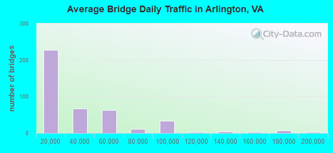
- 13,541,267Total average daily traffic
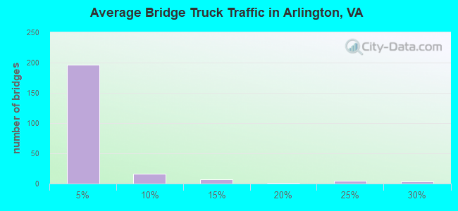
- 182,831Total average daily truck traffic
- National Bridge Inventory (NBI) Registered Bridges for Arlington
- No street view available for this location
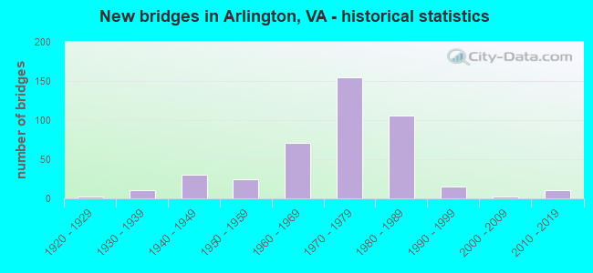
- New bridges - historical statistics
- 11910-1919
- 21920-1929
- 111930-1939
- 301940-1949
- 241950-1959
- 711960-1969
- 1551970-1979
- 1061980-1989
- 151990-1999
- 22000-2009
- 112010-2019
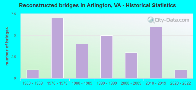
- Reconstructed bridges - Historical Statistics
- 11960-1969
- 71970-1979
- 41980-1989
- 51990-1999
- 32000-2009
- 62010-2019
- 12020-2022
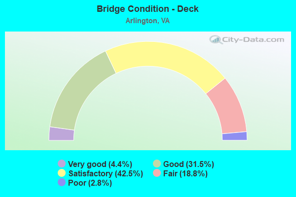
- Bridge Condition - Deck
- 4.4%Very good
- 31.5%Good
- 42.5%Satisfactory
- 18.8%Fair
- 2.8%Poor
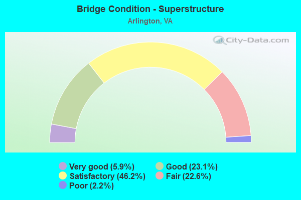
- Bridge Condition - Superstructure
- 5.9%Very good
- 23.1%Good
- 46.2%Satisfactory
- 22.6%Fair
- 2.2%Poor
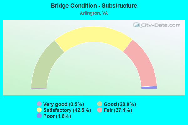
- Bridge Condition - Substructure
- 0.5%Very good
- 28.0%Good
- 42.5%Satisfactory
- 27.4%Fair
- 1.6%Poor
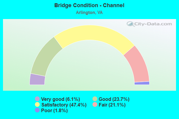
- Bridge Condition - Channel
- 6.1%Very good
- 23.7%Good
- 47.4%Satisfactory
- 21.1%Fair
- 1.8%Poor
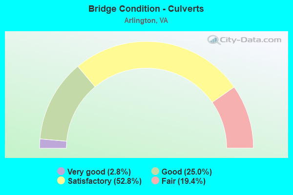
- Bridge Condition - Culverts
- 2.8%Very good
- 25.0%Good
- 52.8%Satisfactory
- 19.4%Fair
Find on map >> Show street view
Structure Number: 27528, Location: 00.86FR50/00.33TO395 (Lat: 38.866003, Lng: -77.073033), Route carried "under" structure: County highway 244, Year Built: 2013, Structure Length: 0. m, Average Daily Traffic: 26,000 (year 2011), Truck Traffic: 4%, Features Intersected: COLUMBIA PIKE, Facility Carried by Structure: WASHINGTON BLVD.NB
Minimum Vertical Clearance: 6.04m (19.82ft), Kilometerpoint: 0.000, Lanes on structure: 3, Lanes under structure: 5, Material/Design: Steel, Design/Construction: Stringer/Multi-beam, Length of Maximum Span: 46.3m (151.9ft)
Find on map >> Show street view
Structure Number: 28579, Location: 00.65FR237/00.98TO120 (Lat: 38.875142, Lng: -77.083875), Route carried "under" structure: US 27, Year Built: 1944, Structure Length: 0. m, Average Daily Traffic: 51,090 (year 1994), Features Intersected: Washington Blvd., Facility Carried by Structure: ARLINGTON BLVD.
Minimum Vertical Clearance: 4.90m (16.08ft), Kilometerpoint: 0.965, Lanes on structure: 4, Lanes under structure: 2, Material/Design: Concrete, Design/Construction: Arch - Deck, Length of Maximum Span: 12.8m (42.0ft)
Find on map >> Show street view
Structure Number: 28579, Location: 00.65FR237/00.98TO120 (Lat: 38.875142, Lng: -77.083875), Route carried "under" structure: US 27, Year Built: 1944, Structure Length: 0. m, Average Daily Traffic: 51,090 (year 1994), Truck Traffic: 3%, Features Intersected: Washington Blvd., Facility Carried by Structure: ARLINGTON BLVD.
Minimum Vertical Clearance: 4.95m (16.24ft), Kilometerpoint: 0.000, Lanes on structure: 4, Lanes under structure: 2, Material/Design: Concrete, Design/Construction: Arch - Deck, Length of Maximum Span: 12.8m (42.0ft)
Find on map >> Show street view
Structure Number: 28646, Location: 00.86FR50/00.33TO395 (Lat: 38.866000, Lng: -77.073528), Route carried "under" structure: County highway 244, Year Built: 2015, Structure Length: 0. m, Average Daily Traffic: 28,000 (year 2011), Truck Traffic: 3%, Features Intersected: COLUMBIA PIKE, Facility Carried by Structure: WASHINGTON BLVD.SB
Minimum Vertical Clearance: 5.59m (18.34ft), Kilometerpoint: 0.000, Lanes on structure: 2, Lanes under structure: 5, Material/Design: Steel, Design/Construction: Stringer/Multi-beam, Length of Maximum Span: 46.9m (153.9ft)