Bridge Statistics for Arlington, Virginia (VA)
Condition, Traffic, Stress, Structural Evaluation, Project Costs
- National Bridge Inventory (NBI) Statistics
- 428Number of bridges
- 4,032ft / 1,229mTotal length
- $292,412,000Total costs
- 13,541,267Total average daily traffic
- 182,831Total average daily truck traffic
- National Bridge Inventory (NBI) Registered Bridges for Arlington
- No street view available for this location
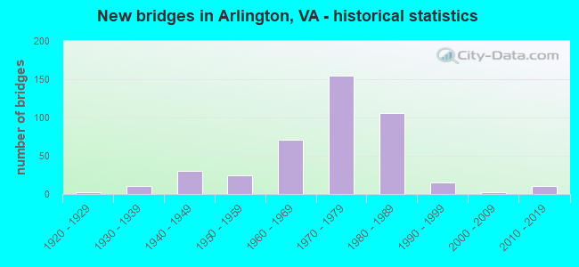
- New bridges - historical statistics
- 11910-1919
- 21920-1929
- 111930-1939
- 301940-1949
- 241950-1959
- 711960-1969
- 1551970-1979
- 1061980-1989
- 151990-1999
- 22000-2009
- 112010-2019
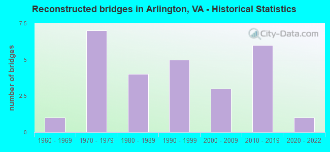
- Reconstructed bridges - Historical Statistics
- 11960-1969
- 71970-1979
- 41980-1989
- 51990-1999
- 32000-2009
- 62010-2019
- 12020-2022
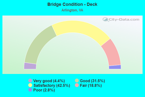
- Bridge Condition - Deck
- 4.4%Very good
- 31.5%Good
- 42.5%Satisfactory
- 18.8%Fair
- 2.8%Poor
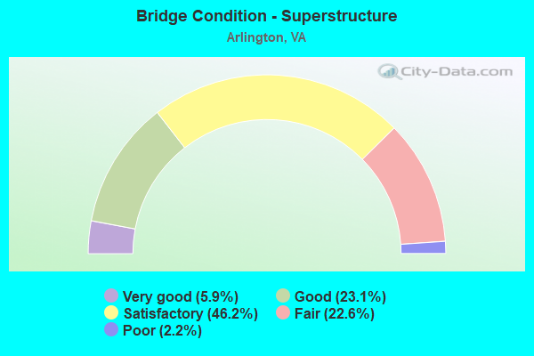
- Bridge Condition - Superstructure
- 5.9%Very good
- 23.1%Good
- 46.2%Satisfactory
- 22.6%Fair
- 2.2%Poor
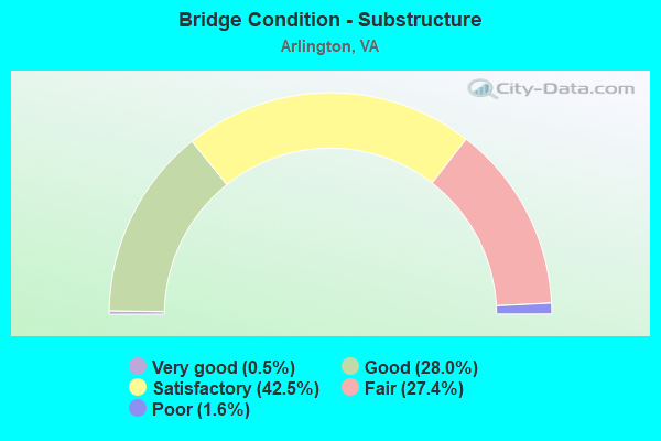
- Bridge Condition - Substructure
- 0.5%Very good
- 28.0%Good
- 42.5%Satisfactory
- 27.4%Fair
- 1.6%Poor
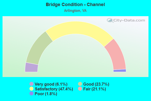
- Bridge Condition - Channel
- 6.1%Very good
- 23.7%Good
- 47.4%Satisfactory
- 21.1%Fair
- 1.8%Poor
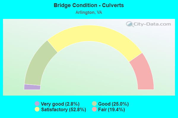
- Bridge Condition - Culverts
- 2.8%Very good
- 25.0%Good
- 52.8%Satisfactory
- 19.4%Fair
Find on map >> Show street view
Structure Number: 117, Location: 046FR223/00.50TO110 (Lat: 38.857369, Lng: -77.052028), Route carried "on" structure: US 1, Year Built: 1988, Status: Open, Structure Length: 4.36m (14.30ft), Average Daily Traffic: 39,324 (year 2020), Truck Traffic: 3%, Average Future Daily Traffic: 51,538 (year 2040), Design Load: HS 20, Features Intersected: 18TH. STREET
Minimum Vertical Clearance: 30+ m (98+ ft), Kilometerpoint: 315.975, Lanes on structure: 11, Lanes under structure: 6, Base Highway Network: Yes, Owner: State Highway Agency, Approaching Roadway Width: 28.0m (91.9ft), Skew: 21 degrees, Material/Design: Steel, Design/Construction: Stringer/Multi-beam, Number Of Spans In Main Unit: 2, Length of Maximum Span: 23.2m (76.1ft), Curb or Sidewalk Widths: Left: 1.8m (5.9ft), Right: 0.0m, Curb-To-Curb Width: 39.0m (128.0ft), Out-to-Out Width: 41.1m (134.8ft)
Condition: Deck: Satisfactory, Superstructure: Good, Substructure: Satisfactory, Operating Rating: 53.7 metric tons, Method Used To Determine Operating Rating: Load and Resistance Factor (LRFR), Inventory Rating: 41.5 metric tons, Method Used To Determine Inventory Rating: Load and Resistance Factor (LRFR), Structural Evaluation: Equal to present minimum criteria, Deck Geometry: High priority of corrective action, Underclear: Somewhat better than minimum adequacy, Approach Roadway Alignment: Equal to present desirable criteria, Length Of Structure Improvement: 4.36m (14.30ft), Designated Inspection Frequency: Every 24 months, Inspection Date: July 2020, Bridge Improvement Cost: $550,000, Roadway Improvement Cost: $55,000, Total Project Cost: $630,000 ( Estimate for 2014), Deck Structure Type: Concrete Cast-file-Place, Wearing Surface/Protective System: Deck Protection: Epoxy Coated Reinforcing
Find on map >> Show street view
Structure Number: 123, Location: 0.3FR244 01.05TO110 (Lat: 38.864911, Lng: -77.068103), Route carried "on" structure: Ramp State highway 27, Year Built: 1973, Status: Open, Structure Length: 1.98m (6.50ft), Average Daily Traffic: 20,313 (year 2020), Truck Traffic: 2%, Average Future Daily Traffic: 26,097 (year 2040), Design Load: HS 20, Features Intersected: RD F O RD B OF 395 U2027
Minimum Vertical Clearance: 5.63m (18.47ft), Kilometerpoint: 0.225, Lanes on structure: 2, Lanes under structure: 2, Base Highway Network: Yes, Owner: State Highway Agency, Approaching Roadway Width: 11.0m (36.1ft), Skew: 2 degrees, Material/Design: Steel, Design/Construction: Stringer/Multi-beam, Number Of Spans In Main Unit: 1, Length of Maximum Span: 19.8m (65.0ft), Curb or Sidewalk Widths: Left: 0.5m (1.6ft), Right: 0.2m (0.7ft), Curb-To-Curb Width: 10.4m (34.1ft), Out-to-Out Width: 11.6m (38.1ft)
Condition: Deck: Satisfactory, Superstructure: Satisfactory, Substructure: Fair, Operating Rating: 56.5 metric tons, Method Used To Determine Operating Rating: Load and Resistance Factor (LRFR), Inventory Rating: 43.5 metric tons, Method Used To Determine Inventory Rating: Load and Resistance Factor (LRFR), Structural Evaluation: Somewhat better than minimum adequacy, Deck Geometry: Better than present minimum criteria, Underclear: High priority of corrective action, Approach Roadway Alignment: Somewhat better than minimum adequacy, Length Of Structure Improvement: 1.98m (6.50ft), Designated Inspection Frequency: Every 24 months, Inspection Date: April 2021, Bridge Improvement Cost: $408,000, Roadway Improvement Cost: $41,000, Total Project Cost: $500,000 ( Estimate for 2015), Deck Structure Type: Concrete Cast-file-Place, Wearing Surface/Protective System: Wearing Surface: Monolithic Concrete
Find on map >> Show street view
Structure Number: 125, Location: 00.55FR110/00.82TO244 (Lat: 38.869528, Lng: -77.060981), Route carried "on" structure: US 27, Year Built: 1945, Status: Open, Structure Length: 2.04m (6.69ft), Average Daily Traffic: 51,478 (year 2020), Truck Traffic: 2%, Average Future Daily Traffic: 72,069 (year 2040), Design Load: HS 20, Features Intersected: ROUTE 244 COLUMBIA PIKE, Facility Carried by Structure: WASHINGTON BLVD.
Minimum Vertical Clearance: 30+ m (98+ ft), Kilometerpoint: 2.784, Lanes on structure: 8, Lanes under structure: 4, Base Highway Network: Yes, Owner: State Highway Agency, Approaching Roadway Width: 43.6m (143.0ft), Skew: 20 degrees, Material/Design: Concrete, Design/Construction: Arch - Deck, Number Of Spans In Main Unit: 1, Length of Maximum Span: 20.4m (66.9ft), Curb or Sidewalk Widths: Left: 0.2m (0.7ft), Right: 1.6m (5.2ft), Curb-To-Curb Width: 23.2m (76.1ft), Out-to-Out Width: 46.0m (150.9ft)
Condition: Deck: Fair, Superstructure: Fair, Substructure: Satisfactory, Operating Rating: 70.7 metric tons, Method Used To Determine Operating Rating: Load and Resistance Factor (LRFR), Inventory Rating: 54.5 metric tons, Method Used To Determine Inventory Rating: Load and Resistance Factor (LRFR), Structural Evaluation: Somewhat better than minimum adequacy, Deck Geometry: High priority of replacement, Underclear: High priority of replacement, Approach Roadway Alignment: Equal to present desirable criteria, Length Of Structure Improvement: 2.13m (6.99ft), Designated Inspection Frequency: Every 24 months, Inspection Date: April 2020, Bridge Improvement Cost: $1,733,000, Roadway Improvement Cost: $173,000, Total Project Cost: $2,000,000 ( Estimate for 2014), Deck Structure Type: Concrete Cast-file-Place, Wearing Surface/Protective System: Wearing Surface: Bituminous
Find on map >> Show street view
Structure Number: 127, Location: 00.71FR110/00.54TO244 (Lat: 38.867683, Lng: -77.063503), Route carried "on" structure: State highway 27, Year Built: 1973, Status: Open, Structure Length: 5.21m (17.09ft), Average Daily Traffic: 27,016 (year 2020), Truck Traffic: 2%, Average Future Daily Traffic: 37,822 (year 2040), Design Load: HS 20, Features Intersected: JOYCE ST., Facility Carried by Structure: WASHINGTON BLVD WB
Minimum Vertical Clearance: 30+ m (98+ ft), Kilometerpoint: 2.381, Lanes on structure: 3, Lanes under structure: 4, Base Highway Network: Yes, Owner: State Highway Agency, Approaching Roadway Width: 14.6m (47.9ft), Skew: 1 degrees, Material/Design: Steel, Design/Construction: Stringer/Multi-beam, Number Of Spans In Main Unit: 2, Length of Maximum Span: 28.0m (91.9ft), Curb or Sidewalk Widths: Left: 0.2m (0.7ft), Right: 0.5m (1.6ft), Curb-To-Curb Width: 14.0m (45.9ft), Out-to-Out Width: 15.3m (50.2ft)
Condition: Deck: Satisfactory, Superstructure: Satisfactory, Substructure: Satisfactory, Operating Rating: 57.9 metric tons, Method Used To Determine Operating Rating: Load and Resistance Factor (LRFR), Inventory Rating: 44.6 metric tons, Method Used To Determine Inventory Rating: Load and Resistance Factor (LRFR), Structural Evaluation: Equal to present minimum criteria, Deck Geometry: Meets minimum limits, Underclear: Superior to present desirable criteria, Approach Roadway Alignment: Equal to present desirable criteria, Length Of Structure Improvement: 5.21m (17.09ft), Designated Inspection Frequency: Every 24 months, Inspection Date: April 2021, Bridge Improvement Cost: $1,416,000, Roadway Improvement Cost: $14,000, Total Project Cost: $1,558,000 ( Estimate for 2015), Deck Structure Type: Concrete Cast-file-Place, Wearing Surface/Protective System: Wearing Surface: Latex Concrete
Find on map >> Show street view
Structure Number: 129, Location: 00.67FR244/01.70TO120 (Lat: 38.867236, Lng: -77.063397), Route carried "on" structure: State highway 27, Year Built: 1973, Status: Open, Structure Length: 5.82m (19.09ft), Average Daily Traffic: 5,193 (year 2020), Average Future Daily Traffic: 7,270 (year 2040), Design Load: HS 20, Features Intersected: JOYCE STREET
Minimum Vertical Clearance: 5.76m (18.90ft), Kilometerpoint: 2.365, Lanes on structure: 1, Lanes under structure: 4, Base Highway Network: Yes, Owner: State Highway Agency, Approaching Roadway Width: 10.4m (34.1ft), Skew: 2 degrees, Material/Design: Steel, Design/Construction: Stringer/Multi-beam, Number Of Spans In Main Unit: 2, Length of Maximum Span: 32.0m (105.0ft), Curb or Sidewalk Widths: Left: 0.2m (0.7ft), Right: 0.2m (0.7ft), Curb-To-Curb Width: 9.8m (32.2ft), Out-to-Out Width: 10.8m (35.4ft)
Condition: Deck: Satisfactory, Superstructure: Satisfactory, Substructure: Fair, Operating Rating: 65.8 metric tons, Method Used To Determine Operating Rating: Load and Resistance Factor (LRFR), Inventory Rating: 50.7 metric tons, Method Used To Determine Inventory Rating: Load and Resistance Factor (LRFR), Structural Evaluation: Somewhat better than minimum adequacy, Deck Geometry: Meets minimum limits, Underclear: Meets minimum limits, Approach Roadway Alignment: Equal to present minimum criteria, Length Of Structure Improvement: 5.82m (19.09ft), Designated Inspection Frequency: Every 24 months, Inspection Date: August 2020, Bridge Improvement Cost: $51,000, Roadway Improvement Cost: $78,000, Total Project Cost: $160,000 ( Estimate for 2014), Deck Structure Type: Concrete Cast-file-Place, Wearing Surface/Protective System: Wearing Surface: Latex Concrete
Find on map >> Show street view
Structure Number: 131, Location: 00.61FR244/00.76TO110 (Lat: 38.866906, Lng: -77.063000), Route carried "on" structure: State highway 27, Year Built: 1973, Status: Open, Structure Length: 3.69m (12.11ft), Average Daily Traffic: 21,268 (year 2020), Truck Traffic: 2%, Average Future Daily Traffic: 29,775 (year 2040), Design Load: HS 20, Features Intersected: JOYCE STREET, Facility Carried by Structure: WASHINGTON BLVD.
Minimum Vertical Clearance: 4.93m (16.17ft), Kilometerpoint: 2.414, Lanes on structure: 3, Lanes under structure: 4, Base Highway Network: Yes, Owner: State Highway Agency, Approaching Roadway Width: 14.6m (47.9ft), Skew: 3 degrees, Material/Design: Steel, Design/Construction: Stringer/Multi-beam, Number Of Spans In Main Unit: 2, Length of Maximum Span: 18.9m (62.0ft), Curb or Sidewalk Widths: Left: 0.5m (1.6ft), Right: 0.2m (0.7ft), Curb-To-Curb Width: 14.0m (45.9ft), Out-to-Out Width: 15.3m (50.2ft)
Condition: Deck: Satisfactory, Superstructure: Fair, Substructure: Fair, Operating Rating: 62.6 metric tons, Method Used To Determine Operating Rating: Load and Resistance Factor (LRFR), Inventory Rating: 48.1 metric tons, Method Used To Determine Inventory Rating: Load and Resistance Factor (LRFR), Structural Evaluation: Somewhat better than minimum adequacy, Deck Geometry: Meets minimum limits, Underclear: Equal to present minimum criteria, Approach Roadway Alignment: Equal to present minimum criteria, Length Of Structure Improvement: 3.69m (12.11ft), Designated Inspection Frequency: Every 24 months, Inspection Date: October 2021, Bridge Improvement Cost: $44,000, Roadway Improvement Cost: $77,000, Total Project Cost: $125,000, Deck Structure Type: Concrete Cast-file-Place, Wearing Surface/Protective System: Wearing Surface: Monolithic Concrete
Find on map >> Show street view
Structure Number: 133, Location: 00.61FR244/00.76TO110 (Lat: 38.866581, Lng: -77.063150), Route carried "on" structure: Ramp State highway 27, Year Built: 1973, Status: Open, Structure Length: 2.96m (9.71ft), Average Daily Traffic: 15,036 (year 2020), Truck Traffic: 2%, Average Future Daily Traffic: 21,050 (year 2040), Design Load: HS 20, Features Intersected: JOYCE STREET
Minimum Vertical Clearance: 4.95m (16.24ft), Kilometerpoint: 1.883, Lanes on structure: 1, Lanes under structure: 8, Base Highway Network: Yes, Owner: State Highway Agency, Approaching Roadway Width: 11.0m (36.1ft), Skew: 1 degrees, Material/Design: Steel, Design/Construction: Stringer/Multi-beam, Number Of Spans In Main Unit: 1, Length of Maximum Span: 29.6m (97.1ft), Curb or Sidewalk Widths: Left: 0.5m (1.6ft), Right: 0.2m (0.7ft), Curb-To-Curb Width: 10.4m (34.1ft), Out-to-Out Width: 11.7m (38.4ft)
Condition: Deck: Satisfactory, Superstructure: Satisfactory, Substructure: Fair, Operating Rating: 52.8 metric tons, Method Used To Determine Operating Rating: Load and Resistance Factor (LRFR), Inventory Rating: 40.7 metric tons, Method Used To Determine Inventory Rating: Load and Resistance Factor (LRFR), Structural Evaluation: Somewhat better than minimum adequacy, Deck Geometry: Somewhat better than minimum adequacy, Underclear: Superior to present desirable criteria, Approach Roadway Alignment: Equal to present desirable criteria, Length Of Structure Improvement: 3.05m (10.01ft), Designated Inspection Frequency: Every 24 months, Inspection Date: May 2021, Bridge Improvement Cost: $160,000, Roadway Improvement Cost: $30,000, Total Project Cost: $199,000 ( Estimate for 2015), Deck Structure Type: Concrete Cast-file-Place, Wearing Surface/Protective System: Wearing Surface: Epoxy Overlay
Find on map >> Show street view
Structure Number: 135, Location: 00.61FR244/00.76TO110 (Lat: 38.866319, Lng: -77.062889), Route carried "on" structure: Ramp State highway 27, Year Built: 1973, Status: Open, Structure Length: 2.77m (9.09ft), Average Daily Traffic: 25,642 (year 2018), Truck Traffic: 2%, Average Future Daily Traffic: 110,000 (year 2033), Design Load: HS 20, Features Intersected: S. JOYCE STREET
Minimum Vertical Clearance: 30+ m (98+ ft), Kilometerpoint: 2.864, Lanes on structure: 2, Lanes under structure: 5, Base Highway Network: Yes, Owner: State Highway Agency, Approaching Roadway Width: 11.0m (36.1ft), Material/Design: Steel, Design/Construction: Stringer/Multi-beam, Number Of Spans In Main Unit: 1, Length of Maximum Span: 27.7m (90.9ft), Curb or Sidewalk Widths: Left: 0.5m (1.6ft), Right: 0.2m (0.7ft), Curb-To-Curb Width: 10.4m (34.1ft), Out-to-Out Width: 11.6m (38.1ft)
Condition: Deck: Satisfactory, Superstructure: Satisfactory, Substructure: Fair, Operating Rating: 51.5 metric tons, Method Used To Determine Operating Rating: Load and Resistance Factor (LRFR), Inventory Rating: 39.7 metric tons, Method Used To Determine Inventory Rating: Load and Resistance Factor (LRFR), Structural Evaluation: Somewhat better than minimum adequacy, Deck Geometry: Better than present minimum criteria, Underclear: Better than present minimum criteria, Approach Roadway Alignment: Equal to present desirable criteria, Length Of Structure Improvement: 2.77m (9.09ft), Designated Inspection Frequency: Every 24 months, Inspection Date: December 2021, Bridge Improvement Cost: $541,000, Roadway Improvement Cost: $54,000, Total Project Cost: $6,000,000, Deck Structure Type: Concrete Cast-file-Place, Wearing Surface/Protective System: Wearing Surface: Latex Concrete
Find on map >> Show street view
Structure Number: 138, Location: 00.55FR244 00.26TO DC (Lat: 38.876264, Lng: -77.057203), Route carried "on" structure: State highway 27, Year Built: 1942, Year Reconstructed: 2016, Status: Open, Structure Length: 14.08m (46.19ft), Average Daily Traffic: 39,207 (year 2020), Truck Traffic: 2%, Average Future Daily Traffic: 54,890 (year 2040), Design Load: HS 20, Features Intersected: RTE. 110 (JEFF DAVIS HWY, Facility Carried by Structure: WASHINGTON BLVD.
Minimum Vertical Clearance: 5.84m (19.16ft), Kilometerpoint: 3.669, Lanes on structure: 6, Lanes under structure: 9, Base Highway Network: Yes, Owner: State Highway Agency, Approaching Roadway Width: 8.2m (26.9ft), Skew: 24 degrees, Material/Design: Steel continuous, Design/Construction: Stringer/Multi-beam, Number Of Spans In Main Unit: 6, Length of Maximum Span: 27.6m (90.6ft), Curb or Sidewalk Widths: Left: 2.4m (7.9ft), Right: 4.3m (14.1ft), Curb-To-Curb Width: 22.9m (75.1ft), Out-to-Out Width: 32.0m (105.0ft)
Condition: Deck: Good, Superstructure: Very good, Substructure: Good, Operating Rating: 78.0 metric tons, Method Used To Determine Operating Rating: Load and Resistance Factor (LRFR), Inventory Rating: 60.4 metric tons, Method Used To Determine Inventory Rating: Load and Resistance Factor (LRFR), Structural Evaluation: Better than present minimum criteria, Deck Geometry: Meets minimum limits, Underclear: High priority of corrective action, Approach Roadway Alignment: Equal to present desirable criteria, Length Of Structure Improvement: 13.72m (45.01ft), Designated Inspection Frequency: Every 24 months, Inspection Date: November 2020, Bridge Improvement Cost: $600,000, Roadway Improvement Cost: $350,000, Total Project Cost: $1,000,000 ( Estimate for 2016), Deck Structure Type: Concrete Cast-file-Place, Wearing Surface/Protective System: Wearing Surface: Monolithic Concrete, Deck Protection: Other Coated Reinforcing
Find on map >> Show street view
Structure Number: 141, Location: 00.05FR395/00.05TO A.R.R. (Lat: 38.861228, Lng: -77.068600), Route carried "on" structure: Ramp State highway 27, Year Built: 1942, Status: Open, Structure Length: 6.37m (20.90ft), Average Daily Traffic: 9,500 (year 2020), Truck Traffic: 2%, Average Future Daily Traffic: 110,000 (year 2035), Design Load: H 20, Features Intersected: ARMY-NAVY DRIVE, Facility Carried by Structure: RAMP AA
Minimum Vertical Clearance: 30+ m (98+ ft), Kilometerpoint: 0.177, Lanes on structure: 3, Lanes under structure: 4, Owner: State Highway Agency, Approaching Roadway Width: 14.6m (47.9ft), Skew: 21 degrees, Material/Design: Concrete, Design/Construction: Tee Beam, Number Of Spans In Main Unit: 3, Length of Maximum Span: 21.9m (71.9ft), Curb or Sidewalk Widths: Left: 1.8m (5.9ft), Right: 0.9m (3.0ft), Curb-To-Curb Width: 14.6m (47.9ft), Out-to-Out Width: 18.6m (61.0ft)
Condition: Deck: Satisfactory, Superstructure: Satisfactory, Substructure: Good, Operating Rating: 47.6 metric tons, Method Used To Determine Operating Rating: Load Factor (LF), Inventory Rating: 28.5 metric tons, Method Used To Determine Inventory Rating: Load Factor (LF), Structural Evaluation: Equal to present minimum criteria, Deck Geometry: Better than present minimum criteria, Underclear: Meets minimum limits, Approach Roadway Alignment: Somewhat better than minimum adequacy, Length Of Structure Improvement: 6.37m (20.90ft), Designated Inspection Frequency: Every 24 months, Inspection Date: May 2021, Bridge Improvement Cost: $2,100,000, Roadway Improvement Cost: $210,000, Total Project Cost: $2,320,000, Deck Structure Type: Concrete Cast-file-Place, Wearing Surface/Protective System: Wearing Surface: Monolithic Concrete
Find on map >> Show street view
Structure Number: 143, Location: 00.20FR27/00.10TO ARL.RG. (Lat: 38.861978, Lng: -77.069717), Route carried "on" structure: Ramp State highway 27, Year Built: 1973, Status: Open, Structure Length: 10.49m (34.42ft), Average Daily Traffic: 2,908 (year 2020), Truck Traffic: 1%, Average Future Daily Traffic: 3,199 (year 2040), Design Load: HS 20, Features Intersected: I395
Minimum Vertical Clearance: 30+ m (98+ ft), Kilometerpoint: 0.129, Lanes on structure: 2, Lanes under structure: 13, Owner: State Highway Agency, Approaching Roadway Width: 9.8m (32.2ft), Skew: 3 degrees, Material/Design: Steel, Design/Construction: Stringer/Multi-beam, Number Of Spans In Main Unit: 4, Length of Maximum Span: 34.1m (111.9ft), Curb or Sidewalk Widths: Left: 0.5m (1.6ft), Right: 1.8m (5.9ft), Curb-To-Curb Width: 7.3m (24.0ft), Out-to-Out Width: 10.2m (33.5ft)
Condition: Deck: Good, Superstructure: Satisfactory, Substructure: Good, Operating Rating: 53.0 metric tons, Method Used To Determine Operating Rating: Load and Resistance Factor (LRFR), Inventory Rating: 40.7 metric tons, Method Used To Determine Inventory Rating: Load and Resistance Factor (LRFR), Structural Evaluation: Equal to present minimum criteria, Deck Geometry: High priority of replacement, Underclear: High priority of corrective action, Approach Roadway Alignment: Equal to present desirable criteria, Length Of Structure Improvement: 10.49m (34.42ft), Designated Inspection Frequency: Every 24 months, Inspection Date: October 2021, Bridge Improvement Cost: $1,890,000, Roadway Improvement Cost: $189,000, Total Project Cost: $2,500,000, Deck Structure Type: Concrete Cast-file-Place, Wearing Surface/Protective System: Wearing Surface: Latex Concrete
Find on map >> Show street view
Structure Number: 147, Location: 00.04FR237/00.55TO694 (Lat: 38.887600, Lng: -77.161800), Route carried "on" structure: US 29, Year Built: 1981, Status: Open, Structure Length: 7.04m (23.10ft), Average Daily Traffic: 16,715 (year 2020), Truck Traffic: 2%, Average Future Daily Traffic: 17,870 (year 2040), Design Load: HS 20, Features Intersected: I-66 & METRO
Minimum Vertical Clearance: 30+ m (98+ ft), Kilometerpoint: 390.681, Lanes on structure: 6, Lanes under structure: 4, Base Highway Network: Yes, Owner: State Highway Agency, Approaching Roadway Width: 24.4m (80.1ft), Material/Design: Steel, Design/Construction: Stringer/Multi-beam, Number Of Spans In Main Unit: 3, Length of Maximum Span: 30.5m (100.1ft), Curb or Sidewalk Widths: Left: 1.5m (4.9ft), Right: 1.5m (4.9ft), Curb-To-Curb Width: 23.2m (76.1ft), Out-to-Out Width: 28.0m (91.9ft)
Condition: Deck: Fair, Superstructure: Satisfactory, Substructure: Satisfactory, Operating Rating: 75.7 metric tons, Method Used To Determine Operating Rating: Load and Resistance Factor (LRFR), Inventory Rating: 58.4 metric tons, Method Used To Determine Inventory Rating: Load and Resistance Factor (LRFR), Structural Evaluation: Equal to present minimum criteria, Deck Geometry: Meets minimum limits, Underclear: Somewhat better than minimum adequacy, Approach Roadway Alignment: Equal to present desirable criteria, Length Of Structure Improvement: 7.04m (23.10ft), Designated Inspection Frequency: Every 24 months, Inspection Date: August 2021, Bridge Improvement Cost: $150,000, Roadway Improvement Cost: $125,000, Total Project Cost: $300,000 ( Estimate for 2015), Deck Structure Type: Concrete Cast-file-Place, Wearing Surface/Protective System: Wearing Surface: Monolithic Concrete, Deck Protection: Epoxy Coated Reinforcing
Find on map >> Show street view
Structure Number: 15, Location: 00.90FR124/01.64TOKEY BRI (Lat: 38.896722, Lng: -77.084431), Route carried "on" structure: US 29, Year Built: 1982, Status: Open, Structure Length: 10.55m (34.61ft), Average Daily Traffic: 2,653 (year 2020), Truck Traffic: 1%, Average Future Daily Traffic: 2,919 (year 2040), Design Load: HS 20, Features Intersected: I-66 (CUSTIS PARKWAY)
Minimum Vertical Clearance: 30+ m (98+ ft), Kilometerpoint: 0.274, Lanes on structure: 3, Lanes under structure: 7, Base Highway Network: Yes, Owner: State Highway Agency, Approaching Roadway Width: 12.2m (40.0ft), Skew: 5 degrees, Material/Design: Steel continuous, Design/Construction: Stringer/Multi-beam, Number Of Spans In Main Unit: 2, Length of Maximum Span: 56.4m (185.0ft), Curb-To-Curb Width: 12.2m (40.0ft), Out-to-Out Width: 16.7m (54.8ft)
Condition: Deck: Satisfactory, Superstructure: Good, Substructure: Satisfactory, Operating Rating: 62.4 metric tons, Method Used To Determine Operating Rating: Load and Resistance Factor (LRFR), Inventory Rating: 48.0 metric tons, Method Used To Determine Inventory Rating: Load and Resistance Factor (LRFR), Structural Evaluation: Equal to present minimum criteria, Deck Geometry: Meets minimum limits, Underclear: High priority of corrective action, Approach Roadway Alignment: Equal to present desirable criteria, Designated Inspection Frequency: Every 24 months, Inspection Date: April 2021, Deck Structure Type: Concrete Cast-file-Place, Wearing Surface/Protective System: Deck Protection: Epoxy Coated Reinforcing
Find on map >> Show street view
Structure Number: 158, Location: 01.29FR120 / 1.80TO7 (Lat: 38.866431, Lng: -77.124083), Route carried "on" structure: US 50, Year Built: 1987, Status: Open, Structure Length: 7.68m (25.20ft), Average Daily Traffic: 48,568 (year 2020), Truck Traffic: 1%, Average Future Daily Traffic: 52,354 (year 2040), Design Load: HS 20, Features Intersected: FOUR MILE RUN, Facility Carried by Structure: ARLINGTON BLVD.
Minimum Vertical Clearance: 30+ m (98+ ft), Kilometerpoint: 131.504, Lanes on structure: 6, Base Highway Network: Yes, Owner: State Highway Agency, Approaching Roadway Width: 12.2m (40.0ft), Skew: 24 degrees, Material/Design: Steel, Design/Construction: Stringer/Multi-beam, Number Of Spans In Main Unit: 4, Length of Maximum Span: 18.0m (59.1ft), Curb or Sidewalk Widths: Left: 2.4m (7.9ft), Right: 2.4m (7.9ft), Curb-To-Curb Width: 24.4m (80.1ft), Out-to-Out Width: 31.9m (104.7ft)
Condition: Deck: Satisfactory, Superstructure: Fair, Substructure: Satisfactory, Channel: Satisfactory, Operating Rating: 97.1 metric tons, Method Used To Determine Operating Rating: Load and Resistance Factor (LRFR), Inventory Rating: 74.4 metric tons, Method Used To Determine Inventory Rating: Load and Resistance Factor (LRFR), Structural Evaluation: Somewhat better than minimum adequacy, Deck Geometry: Somewhat better than minimum adequacy, Waterway Adequacy: Equal to present desirable criteria, Approach Roadway Alignment: Equal to present desirable criteria, Length Of Structure Improvement: 0.49m (1.61ft), Designated Inspection Frequency: Every 24 months, Inspection Date: April 2021, Bridge Improvement Cost: $51,000, Roadway Improvement Cost: $780,000, Total Project Cost: $1,500,000 ( Estimate for 2015), Deck Structure Type: Concrete Cast-file-Place, Wearing Surface/Protective System: Wearing Surface: Monolithic Concrete
Find on map >> Show street view
Structure Number: 159, Location: 01.53FR120/01.50TO7 (Lat: 38.866347, Lng: -77.128539), Route carried "on" structure: US 50, Year Built: 1987, Status: Open, Structure Length: 2.80m (9.19ft), Average Daily Traffic: 48,568 (year 2020), Truck Traffic: 1%, Average Future Daily Traffic: 52,354 (year 2040), Design Load: HS 20, Features Intersected: CARLYN SPRING RD, Facility Carried by Structure: ARLINGTON BLVD.
Minimum Vertical Clearance: 30+ m (98+ ft), Kilometerpoint: 131.138, Lanes on structure: 6, Lanes under structure: 6, Base Highway Network: Yes, Owner: State Highway Agency, Approaching Roadway Width: 24.4m (80.1ft), Skew: 20 degrees, Material/Design: Steel, Design/Construction: Stringer/Multi-beam, Number Of Spans In Main Unit: 1, Length of Maximum Span: 26.8m (87.9ft), Curb-To-Curb Width: 24.4m (80.1ft), Out-to-Out Width: 26.6m (87.3ft)
Condition: Deck: Satisfactory, Superstructure: Good, Substructure: Satisfactory, Operating Rating: 89.8 metric tons, Method Used To Determine Operating Rating: Load and Resistance Factor (LRFR), Inventory Rating: 78.9 metric tons, Method Used To Determine Inventory Rating: Load and Resistance Factor (LRFR), Structural Evaluation: Equal to present minimum criteria, Deck Geometry: Somewhat better than minimum adequacy, Underclear: Equal to present minimum criteria, Approach Roadway Alignment: Equal to present desirable criteria, Length Of Structure Improvement: 0.30m (0.98ft), Designated Inspection Frequency: Every 24 months, Inspection Date: August 2021, Bridge Improvement Cost: $10,000, Roadway Improvement Cost: $10,000, Total Project Cost: $30,000 ( Estimate for 2015), Deck Structure Type: Concrete Cast-file-Place, Wearing Surface/Protective System: Wearing Surface: Monolithic Concrete, Deck Protection: Epoxy Coated Reinforcing
Find on map >> Show street view
Structure Number: 164, Location: 00.11FR.WASHDC/00.20TO110 (Lat: 38.890264, Lng: -77.066539), Route carried "on" structure: US 50, Year Built: 1965, Status: Open, Structure Length: 4.39m (14.40ft), Average Daily Traffic: 24,121 (year 2020), Truck Traffic: 1%, Average Future Daily Traffic: 33,771 (year 2040), Design Load: HS 20, Features Intersected: RAMP C FROM GW PARKWAY
Minimum Vertical Clearance: 30+ m (98+ ft), Kilometerpoint: 138.213, Lanes on structure: 1, Lanes under structure: 2, Base Highway Network: Yes, Owner: State Highway Agency, Approaching Roadway Width: 12.8m (42.0ft), Skew: 2 degrees, Material/Design: Steel, Design/Construction: Stringer/Multi-beam, Number Of Spans In Main Unit: 3, Length of Maximum Span: 17.4m (57.1ft), Curb-To-Curb Width: 11.6m (38.1ft), Out-to-Out Width: 12.2m (40.0ft)
Condition: Deck: Satisfactory, Superstructure: Satisfactory, Substructure: Fair, Operating Rating: 55.2 metric tons, Method Used To Determine Operating Rating: Load and Resistance Factor (LRFR), Inventory Rating: 42.5 metric tons, Method Used To Determine Inventory Rating: Load and Resistance Factor (LRFR), Structural Evaluation: Somewhat better than minimum adequacy, Deck Geometry: Somewhat better than minimum adequacy, Underclear: High priority of replacement, Approach Roadway Alignment: Equal to present minimum criteria, Length Of Structure Improvement: 4.39m (14.40ft), Designated Inspection Frequency: Every 24 months, Inspection Date: September 2021, Bridge Improvement Cost: $1,236,000, Roadway Improvement Cost: $124,000, Total Project Cost: $1,560,000, Deck Structure Type: Concrete Cast-file-Place, Wearing Surface/Protective System: Wearing Surface: Monolithic Concrete
Find on map >> Show street view
Structure Number: 17, Location: 01.25FR10TH/00.90TO23RD (Lat: 38.890831, Lng: -77.068261), Route carried "on" structure: Ramp State highway 50, Year Built: 1965, Status: Open, Structure Length: 2.77m (9.09ft), Average Daily Traffic: 24,121 (year 2020), Truck Traffic: 1%, Average Future Daily Traffic: 33,771 (year 2040), Design Load: HS 20, Features Intersected: ROUTE 110, Facility Carried by Structure: ARLINGTON BLVD. WB
Minimum Vertical Clearance: 30+ m (98+ ft), Kilometerpoint: 10.700, Lanes on structure: 3, Lanes under structure: 4, Base Highway Network: Yes, Owner: State Highway Agency, Approaching Roadway Width: 14.3m (46.9ft), Material/Design: Steel, Design/Construction: Stringer/Multi-beam, Number Of Spans In Main Unit: 1, Length of Maximum Span: 27.7m (90.9ft), Curb or Sidewalk Widths: Left: 0.5m (1.6ft), Right: 0.5m (1.6ft), Curb-To-Curb Width: 13.4m (44.0ft), Out-to-Out Width: 14.9m (48.9ft)
Condition: Deck: Fair, Superstructure: Satisfactory, Substructure: Fair, Operating Rating: 55.5 metric tons, Method Used To Determine Operating Rating: Load and Resistance Factor (LRFR), Inventory Rating: 42.8 metric tons, Method Used To Determine Inventory Rating: Load and Resistance Factor (LRFR), Structural Evaluation: Somewhat better than minimum adequacy, Deck Geometry: Somewhat better than minimum adequacy, Underclear: High priority of replacement, Approach Roadway Alignment: Equal to present minimum criteria, Length Of Structure Improvement: 2.77m (9.09ft), Designated Inspection Frequency: Every 24 months, Inspection Date: July 2020, Bridge Improvement Cost: $916,000, Roadway Improvement Cost: $92,000, Total Project Cost: $1,018,000 ( Estimate for 2014), Deck Structure Type: Concrete Cast-file-Place, Wearing Surface/Protective System: Wearing Surface: Epoxy Overlay
Find on map >> Show street view
Structure Number: 172, Location: 01.25FR10TH/00.90TO23RD (Lat: 38.890425, Lng: -77.068150), Route carried "on" structure: Ramp State highway 50, Year Built: 1965, Status: Open, Structure Length: 3.54m (11.61ft), Average Daily Traffic: 24,121 (year 2020), Truck Traffic: 1%, Average Future Daily Traffic: 33,771 (year 2040), Design Load: HS 20, Features Intersected: ROUTE 110, Facility Carried by Structure: ARLINGTON BLVD. EB
Minimum Vertical Clearance: 30+ m (98+ ft), Kilometerpoint: 10.748, Lanes on structure: 4, Lanes under structure: 4, Base Highway Network: Yes, Owner: State Highway Agency, Approaching Roadway Width: 12.2m (40.0ft), Skew: 4 degrees, Material/Design: Steel, Design/Construction: Stringer/Multi-beam, Number Of Spans In Main Unit: 2, Length of Maximum Span: 18.3m (60.0ft), Curb or Sidewalk Widths: Left: 0.5m (1.6ft), Right: 0.5m (1.6ft), Curb-To-Curb Width: 17.4m (57.1ft), Out-to-Out Width: 18.9m (62.0ft)
Condition: Deck: Fair, Superstructure: Fair, Substructure: Fair, Operating Rating: 49.0 metric tons, Method Used To Determine Operating Rating: Load and Resistance Factor (LRFR), Inventory Rating: 38.1 metric tons, Method Used To Determine Inventory Rating: Load and Resistance Factor (LRFR), Structural Evaluation: Somewhat better than minimum adequacy, Deck Geometry: Equal to present minimum criteria, Underclear: High priority of corrective action, Approach Roadway Alignment: Equal to present minimum criteria, Length Of Structure Improvement: 3.54m (11.61ft), Designated Inspection Frequency: Every 24 months, Inspection Date: July 2020, Bridge Improvement Cost: $220,000, Roadway Improvement Cost: $22,000, Total Project Cost: $250,000 ( Estimate for 2014), Deck Structure Type: Concrete Cast-file-Place, Wearing Surface/Protective System: Wearing Surface: Epoxy Overlay
Find on map >> Show street view
Structure Number: 174, Location: 1.11FR29/01.00TOCONSTITU (Lat: 38.893378, Lng: -77.067408), Route carried "on" structure: Interstate 66, Year Built: 1965, Year Reconstructed: 2019, Status: Open, Structure Length: 4.51m (14.80ft), Average Daily Traffic: 71,946 (year 2020), Truck Traffic: 1%, Average Future Daily Traffic: 100,724 (year 2040), Design Load: HS 20, Features Intersected: RMPS B & F, Facility Carried by Structure: CUSTIS MEM. HWY.
Minimum Vertical Clearance: 4.57m (14.99ft), Kilometerpoint: 119.999, Lanes on structure: 4, Lanes under structure: 2, Base Highway Network: Yes, Owner: State Highway Agency, Approaching Roadway Width: 16.2m (53.1ft), Skew: 24 degrees, Material/Design: Steel, Design/Construction: Stringer/Multi-beam, Number Of Spans In Main Unit: 2, Length of Maximum Span: 25.6m (84.0ft), Curb-To-Curb Width: 30.9m (101.4ft), Out-to-Out Width: 32.3m (106.0ft)
Condition: Deck: Good, Superstructure: Good, Substructure: Good, Operating Rating: 60.6 metric tons, Method Used To Determine Operating Rating: Load and Resistance Factor (LRFR), Inventory Rating: 46.7 metric tons, Method Used To Determine Inventory Rating: Load and Resistance Factor (LRFR), Structural Evaluation: Better than present minimum criteria, Deck Geometry: Superior to present desirable criteria, Underclear: High priority of replacement, Approach Roadway Alignment: Somewhat better than minimum adequacy, Length Of Structure Improvement: 6.10m (20.01ft), Designated Inspection Frequency: Every 24 months, Inspection Date: June 2021, Bridge Improvement Cost: $2,000,000, Roadway Improvement Cost: $50,000, Total Project Cost: $2,100,000 ( Estimate for 2015), Deck Structure Type: Concrete Cast-file-Place, Wearing Surface/Protective System: Wearing Surface: Latex Concrete
Find on map >> Show street view
Structure Number: 177, Location: 01.10 29 / 00.20 50 (Lat: 38.893272, Lng: -77.067706), Route carried "on" structure: Ramp Interstate 66, Year Built: 1965, Status: Open, Structure Length: 2.80m (9.19ft), Average Daily Traffic: 19,420 (year 2020), Average Future Daily Traffic: 27,188 (year 2040), Design Load: HS 20, Features Intersected: ROUTE 110
Minimum Vertical Clearance: 30+ m (98+ ft), Kilometerpoint: 0.032, Lanes on structure: 1, Lanes under structure: 2, Base Highway Network: Yes, Owner: State Highway Agency, Approaching Roadway Width: 9.1m (29.9ft), Skew: 1 degrees, Material/Design: Steel, Design/Construction: Stringer/Multi-beam, Number Of Spans In Main Unit: 1, Length of Maximum Span: 16.5m (54.1ft), Curb-To-Curb Width: 9.1m (29.9ft), Out-to-Out Width: 9.8m (32.2ft)
Condition: Deck: Satisfactory, Superstructure: Satisfactory, Substructure: Fair, Operating Rating: 62.4 metric tons, Method Used To Determine Operating Rating: Load and Resistance Factor (LRFR), Inventory Rating: 48.2 metric tons, Method Used To Determine Inventory Rating: Load and Resistance Factor (LRFR), Structural Evaluation: Somewhat better than minimum adequacy, Deck Geometry: Superior to present desirable criteria, Approach Roadway Alignment: Equal to present desirable criteria, Designated Inspection Frequency: Every 24 months, Inspection Date: June 2020, Bridge Improvement Cost: $262,000, Roadway Improvement Cost: $100,000, Total Project Cost: $400,000 ( Estimate for 2014), Deck Structure Type: Concrete Cast-file-Place, Wearing Surface/Protective System: Wearing Surface: Latex Concrete
Find on map >> Show street view
Structure Number: 181, Location: 01.90FR7/00.42TO237 (Lat: 38.892267, Lng: -77.166575), Route carried "on" structure: Interstate 66, Year Built: 1981, Status: Open, Structure Length: 6.89m (22.60ft), Average Daily Traffic: 38,261 (year 2020), Truck Traffic: 1%, Average Future Daily Traffic: 53,565 (year 2040), Design Load: HS 20, Features Intersected: 00-06780 WESTMORELAND ST
Minimum Vertical Clearance: 30+ m (98+ ft), Kilometerpoint: 110.410, Lanes on structure: 3, Lanes under structure: 4, Base Highway Network: Yes, Owner: State Highway Agency, Approaching Roadway Width: 26.7m (87.6ft), Skew: 4 degrees, Material/Design: Steel, Design/Construction: Stringer/Multi-beam, Number Of Spans In Main Unit: 3, Length of Maximum Span: 28.0m (91.9ft), Curb or Sidewalk Widths: Left: 0.2m (0.7ft), Right: 0.2m (0.7ft), Curb-To-Curb Width: 25.5m (83.7ft), Out-to-Out Width: 26.5m (86.9ft)
Condition: Deck: Good, Superstructure: Satisfactory, Substructure: Satisfactory, Operating Rating: 63.5 metric tons, Method Used To Determine Operating Rating: Load and Resistance Factor (LRFR), Inventory Rating: 49.0 metric tons, Method Used To Determine Inventory Rating: Load and Resistance Factor (LRFR), Structural Evaluation: Equal to present minimum criteria, Deck Geometry: Superior to present desirable criteria, Underclear: Meets minimum limits, Approach Roadway Alignment: Equal to present desirable criteria, Length Of Structure Improvement: 0.30m (0.98ft), Designated Inspection Frequency: Every 24 months, Inspection Date: July 2021, Bridge Improvement Cost: $20,000, Roadway Improvement Cost: $20,000, Total Project Cost: $50,000 ( Estimate for 2015), Deck Structure Type: Concrete Cast-file-Place, Wearing Surface/Protective System: Wearing Surface: Monolithic Concrete, Deck Protection: Epoxy Coated Reinforcing
Find on map >> Show street view
Structure Number: 185, Location: 01.28FR120 00.87TO29N (Lat: 38.895819, Lng: -77.099047), Route carried "on" structure: Interstate 66, Year Built: 1981, Status: Open, Structure Length: 8.08m (26.51ft), Average Daily Traffic: 65,936 (year 2020), Truck Traffic: 1%, Average Future Daily Traffic: 83,108 (year 2040), Design Load: HS 20, Features Intersected: LEE HIGHWAY_RTE 29
Minimum Vertical Clearance: 30+ m (98+ ft), Kilometerpoint: 7.466, Lanes on structure: 4, Lanes under structure: 7, Base Highway Network: Yes, Owner: State Highway Agency, Approaching Roadway Width: 26.8m (87.9ft), Skew: 3 degrees, Material/Design: Steel, Design/Construction: Stringer/Multi-beam, Number Of Spans In Main Unit: 3, Length of Maximum Span: 44.8m (147.0ft), Curb or Sidewalk Widths: Left: 0.2m (0.7ft), Right: 0.2m (0.7ft), Curb-To-Curb Width: 26.8m (87.9ft), Out-to-Out Width: 28.4m (93.2ft)
Condition: Deck: Satisfactory, Superstructure: Satisfactory, Substructure: Satisfactory, Operating Rating: 65.3 metric tons, Method Used To Determine Operating Rating: Load and Resistance Factor (LRFR), Inventory Rating: 49.9 metric tons, Method Used To Determine Inventory Rating: Load and Resistance Factor (LRFR), Structural Evaluation: Equal to present minimum criteria, Deck Geometry: Superior to present desirable criteria, Underclear: Somewhat better than minimum adequacy, Approach Roadway Alignment: Equal to present desirable criteria, Length Of Structure Improvement: 8.08m (26.51ft), Designated Inspection Frequency: Every 24 months, Inspection Date: September 2021, Bridge Improvement Cost: $100,000, Roadway Improvement Cost: $100,000, Total Project Cost: $300,000, Deck Structure Type: Concrete Cast-file-Place, Wearing Surface/Protective System: Wearing Surface: Monolithic Concrete, Deck Protection: Epoxy Coated Reinforcing
Find on map >> Show street view
Structure Number: 187, Location: 01.60FR7/00.60TO29 (Lat: 38.894147, Lng: -77.169667), Route carried "on" structure: Interstate 66, Year Built: 1981, Year Reconstructed: 2020, Status: Open, Structure Length: 5.15m (16.90ft), Average Daily Traffic: 36,328 (year 2020), Truck Traffic: 1%, Average Future Daily Traffic: 50,859 (year 2040), Design Load: HS 20, Features Intersected: WILLIAMSBURG BLVD.
Minimum Vertical Clearance: 30+ m (98+ ft), Kilometerpoint: 109.380, Lanes on structure: 2, Lanes under structure: 4, Base Highway Network: Yes, Owner: State Highway Agency, Approaching Roadway Width: 19.5m (64.0ft), Skew: 2 degrees, Material/Design: Steel, Design/Construction: Stringer/Multi-beam, Number Of Spans In Main Unit: 3, Number Of Approach Spans: 2, Length of Maximum Span: 24.7m (81.0ft), Curb-To-Curb Width: 19.5m (64.0ft), Out-to-Out Width: 20.4m (66.9ft)
Condition: Deck: Good, Superstructure: Good, Substructure: Satisfactory, Operating Rating: 72.2 metric tons, Method Used To Determine Operating Rating: Load and Resistance Factor (LRFR), Inventory Rating: 55.7 metric tons, Method Used To Determine Inventory Rating: Load and Resistance Factor (LRFR), Structural Evaluation: Equal to present minimum criteria, Deck Geometry: Superior to present desirable criteria, Underclear: Equal to present minimum criteria, Approach Roadway Alignment: Equal to present desirable criteria, Length Of Structure Improvement: 1.52m (4.99ft), Designated Inspection Frequency: Every 24 months, Inspection Date: July 2021, Bridge Improvement Cost: $100,000, Roadway Improvement Cost: $50,000, Total Project Cost: $160,000, Deck Structure Type: Concrete Cast-file-Place, Wearing Surface/Protective System: Wearing Surface: Monolithic Concrete, Deck Protection: Epoxy Coated Reinforcing
Find on map >> Show street view
Structure Number: 189, Location: 01.60FR7/00.60TO29 (Lat: 38.894308, Lng: -77.169056), Route carried "on" structure: Interstate 66, Year Built: 1981, Year Reconstructed: 2015, Status: Open, Structure Length: 5.15m (16.90ft), Average Daily Traffic: 38,261 (year 2020), Truck Traffic: 1%, Average Future Daily Traffic: 53,565 (year 2040), Design Load: HS 20, Features Intersected: WILLIAMSBURG BLVD.
Minimum Vertical Clearance: 30+ m (98+ ft), Kilometerpoint: 110.007, Lanes on structure: 4, Lanes under structure: 2, Base Highway Network: Yes, Owner: State Highway Agency, Approaching Roadway Width: 22.6m (74.1ft), Skew: 1 degrees, Material/Design: Steel, Design/Construction: Stringer/Multi-beam, Number Of Spans In Main Unit: 3, Number Of Approach Spans: 2, Length of Maximum Span: 24.7m (81.0ft), Curb-To-Curb Width: 21.9m (71.9ft), Out-to-Out Width: 23.0m (75.5ft)
Condition: Deck: Good, Superstructure: Satisfactory, Substructure: Good, Operating Rating: 85.8 metric tons, Method Used To Determine Operating Rating: Load and Resistance Factor (LRFR), Inventory Rating: 66.2 metric tons, Method Used To Determine Inventory Rating: Load and Resistance Factor (LRFR), Structural Evaluation: Equal to present minimum criteria, Deck Geometry: Better than present minimum criteria, Underclear: High priority of corrective action, Approach Roadway Alignment: Equal to present desirable criteria, Length Of Structure Improvement: 5.15m (16.90ft), Designated Inspection Frequency: Every 24 months, Inspection Date: July 2021, Bridge Improvement Cost: $55,000, Roadway Improvement Cost: $88,000, Total Project Cost: $150,000, Deck Structure Type: Concrete Cast-file-Place, Wearing Surface/Protective System: Wearing Surface: Monolithic Concrete, Deck Protection: Epoxy Coated Reinforcing
Find on map >> Show street view
Structure Number: 191, Location: 00.30FR29S/ 00.57TO29N (Lat: 38.897572, Lng: -77.094814), Route carried "on" structure: Interstate 66, Year Built: 1981, Status: Open, Structure Length: 16.43m (53.90ft), Average Daily Traffic: 65,936 (year 2020), Truck Traffic: 1%, Average Future Daily Traffic: 83,108 (year 2040), Design Load: HS 20, Features Intersected: ROUTE 124 AND SPOUT RUN
Minimum Vertical Clearance: 30+ m (98+ ft), Kilometerpoint: 7.916, Lanes on structure: 4, Lanes under structure: 4, Base Highway Network: Yes, Owner: State Highway Agency, Approaching Roadway Width: 13.4m (44.0ft), Skew: 23 degrees, Material/Design: Steel, Design/Construction: Stringer/Multi-beam, Number Of Spans In Main Unit: 4, Length of Maximum Span: 47.2m (154.9ft), Curb or Sidewalk Widths: Left: 0.2m (0.7ft), Right: 0.2m (0.7ft), Curb-To-Curb Width: 26.8m (87.9ft), Out-to-Out Width: 32.1m (105.3ft)
Condition: Deck: Satisfactory, Superstructure: Satisfactory, Substructure: Fair, Channel: Satisfactory, Operating Rating: 65.0 metric tons, Method Used To Determine Operating Rating: Load and Resistance Factor (LRFR), Inventory Rating: 50.1 metric tons, Method Used To Determine Inventory Rating: Load and Resistance Factor (LRFR), Structural Evaluation: Somewhat better than minimum adequacy, Deck Geometry: Superior to present desirable criteria, Underclear: Meets minimum limits, Waterway Adequacy: Equal to present desirable criteria, Approach Roadway Alignment: Equal to present desirable criteria, Length Of Structure Improvement: 16.43m (53.90ft), Designated Inspection Frequency: Every 24 months, Inspection Date: September 2021, Bridge Improvement Cost: $100,000, Roadway Improvement Cost: $100,000, Total Project Cost: $300,000, Deck Structure Type: Concrete Cast-file-Place, Wearing Surface/Protective System: Wearing Surface: Monolithic Concrete, Deck Protection: Epoxy Coated Reinforcing
Find on map >> Show street view
Structure Number: 198, Location: 0.90FaDr/0.90NSycamore (Lat: 38.879233, Lng: -77.136311), Route carried "on" structure: Interstate 66, Year Built: 1982, Status: Open, Structure Length: 2.50m (8.20ft), Average Daily Traffic: 31,811 (year 2020), Truck Traffic: 1%, Average Future Daily Traffic: 44,535 (year 2040), Design Load: HS 20, Features Intersected: 4 MILE RUN & BIKE TRAIL
Minimum Vertical Clearance: 30+ m (98+ ft), Kilometerpoint: 112.759, Lanes on structure: 2, Base Highway Network: Yes, Owner: State Highway Agency, Approaching Roadway Width: 13.4m (44.0ft), Material/Design: Steel, Design/Construction: Box Beam or Girders - Multiple, Number Of Spans In Main Unit: 1, Length of Maximum Span: 25.0m (82.0ft), Curb or Sidewalk Widths: Left: 0.2m (0.7ft), Right: 0.2m (0.7ft), Curb-To-Curb Width: 13.4m (44.0ft), Out-to-Out Width: 14.4m (47.2ft)
Condition: Deck: Very good, Superstructure: Satisfactory, Substructure: Good, Channel: Satisfactory, Operating Rating: 89.8 metric tons, Method Used To Determine Operating Rating: Load and Resistance Factor (LRFR), Inventory Rating: 77.6 metric tons, Method Used To Determine Inventory Rating: Load and Resistance Factor (LRFR), Structural Evaluation: Equal to present minimum criteria, Deck Geometry: Superior to present desirable criteria, Approach Roadway Alignment: Equal to present desirable criteria, Length Of Structure Improvement: 2.50m (8.20ft), Designated Inspection Frequency: Every 24 months, Inspection Date: July 2020, Bridge Improvement Cost: $51,000, Roadway Improvement Cost: $79,000, Total Project Cost: $150,000 ( Estimate for 2014), Deck Structure Type: Concrete Cast-file-Place, Wearing Surface/Protective System: Deck Protection: Epoxy Coated Reinforcing
Find on map >> Show street view
Structure Number: 202, Location: 1.45FR29/0.12TO237 (Lat: 38.884533, Lng: -77.119272), Route carried "on" structure: Interstate 66, Year Built: 1982, Status: Open, Structure Length: 1.01m (3.31ft), Average Daily Traffic: 64,923 (year 2020), Truck Traffic: 1%, Average Future Daily Traffic: 84,690 (year 2040), Design Load: HS 20, Features Intersected: LUBBER RUN, Facility Carried by Structure: CUSTIS MEM. PKWY
Minimum Vertical Clearance: 30+ m (98+ ft), Kilometerpoint: 5.165, Lanes on structure: 4, Base Highway Network: Yes, Owner: State Highway Agency, Approaching Roadway Width: 24.4m (80.1ft), Skew: 4 degrees, Material/Design: Concrete, Design/Construction: Culvert, Number Of Spans In Main Unit: 3, Length of Maximum Span: 3.4m (11.2ft)
Condition: Channel: Satisfactory, Culverts: Satisfactory, Operating Rating: 63.5 metric tons, Method Used To Determine Operating Rating: Load Factor (LF), Inventory Rating: 38.1 metric tons, Method Used To Determine Inventory Rating: Load Factor (LF), Structural Evaluation: Equal to present minimum criteria, Waterway Adequacy: Somewhat better than minimum adequacy, Approach Roadway Alignment: Equal to present desirable criteria, Length Of Structure Improvement: 0.30m (0.98ft), Designated Inspection Frequency: Every 24 months, Inspection Date: April 2021, Bridge Improvement Cost: $1,000, Roadway Improvement Cost: $2,000, Total Project Cost: $4,000
Find on map >> Show street view
Structure Number: 205, Location: 0.2FR693/1.65TO RTE 7 (Lat: 38.893036, Lng: -77.168344), Route carried "on" structure: Interstate 66, Year Built: 1982, Status: Open, Structure Length: 1.55m (5.09ft), Average Daily Traffic: 74,589 (year 2020), Truck Traffic: 1%, Average Future Daily Traffic: 104,425 (year 2040), Design Load: HS 20, Features Intersected: Four Mile Run, Facility Carried by Structure: Custis Mem. Pkwy.
Minimum Vertical Clearance: 30+ m (98+ ft), Kilometerpoint: 109.557, Lanes on structure: 5, Base Highway Network: Yes, Owner: State Highway Agency, Approaching Roadway Width: 28.0m (91.9ft), Skew: 4 degrees, Material/Design: Concrete, Design/Construction: Culvert, Number Of Spans In Main Unit: 3, Length of Maximum Span: 5.5m (18.0ft)
Condition: Channel: Satisfactory, Culverts: Satisfactory, Operating Rating: 44.5 metric tons, Method Used To Determine Operating Rating: Field evaluation and documented engineering judgment, Inventory Rating: 32.7 metric tons, Method Used To Determine Inventory Rating: Field evaluation and documented engineering judgment, Structural Evaluation: Equal to present minimum criteria, Waterway Adequacy: Equal to present desirable criteria, Approach Roadway Alignment: Equal to present desirable criteria, Length Of Structure Improvement: 0.30m (0.98ft), Designated Inspection Frequency: Every 24 months, Inspection Date: April 2021, Bridge Improvement Cost: $1,000, Roadway Improvement Cost: $2,000, Total Project Cost: $4,000 ( Estimate for 2015)
Find on map >> Show street view
Structure Number: 22, Location: 01.07FR1/00.55TO395 (Lat: 38.844394, Lng: -77.071311), Route carried "on" structure: State highway 120, Year Built: 1980, Status: Open, Structure Length: 3.84m (12.60ft), Average Daily Traffic: 27,221 (year 2020), Truck Traffic: 3%, Average Future Daily Traffic: 29,943 (year 2040), Design Load: HS 20, Features Intersected: LONG BRANCH, Facility Carried by Structure: GLEBE RD.
Minimum Vertical Clearance: 30+ m (98+ ft), Kilometerpoint: 12.883, Lanes on structure: 4, Base Highway Network: Yes, Owner: State Highway Agency, Approaching Roadway Width: 14.6m (47.9ft), Skew: 20 degrees, Material/Design: Concrete continuous, Design/Construction: Slab, Number Of Spans In Main Unit: 3, Length of Maximum Span: 14.6m (47.9ft), Curb or Sidewalk Widths: Left: 2.6m (8.5ft), Right: 2.6m (8.5ft), Curb-To-Curb Width: 19.7m (64.6ft), Out-to-Out Width: 29.1m (95.5ft)
Condition: Deck: Fair, Superstructure: Fair, Substructure: Satisfactory, Channel: Satisfactory, Operating Rating: 39.0 metric tons, Method Used To Determine Operating Rating: Load and Resistance Factor (LRFR), Inventory Rating: 29.9 metric tons, Method Used To Determine Inventory Rating: Load and Resistance Factor (LRFR), Structural Evaluation: Somewhat better than minimum adequacy, Deck Geometry: Better than present minimum criteria, Waterway Adequacy: Equal to present desirable criteria, Approach Roadway Alignment: Better than present minimum criteria, Length Of Structure Improvement: 3.84m (12.60ft), Designated Inspection Frequency: Every 24 months, Inspection Date: December 2020, Bridge Improvement Cost: $6,000,000, Roadway Improvement Cost: $10,000, Total Project Cost: $6,050,000 ( Estimate for 2014), Deck Structure Type: Concrete Cast-file-Place, Wearing Surface/Protective System: Wearing Surface: Monolithic Concrete
Find on map >> Show street view
Structure Number: 226, Location: 00.30 237 / 00.85 29 (Lat: 38.886794, Lng: -77.117933), Route carried "on" structure: State highway 120, Year Built: 1982, Status: Open, Structure Length: 5.21m (17.09ft), Average Daily Traffic: 29,549 (year 2020), Truck Traffic: 3%, Average Future Daily Traffic: 32,504 (year 2040), Design Load: HS 20+Mod, Features Intersected: CUSTIS MEM. PKWY (I-66), Facility Carried by Structure: GLEBE ROAD
Minimum Vertical Clearance: 30+ m (98+ ft), Kilometerpoint: 6.179, Lanes on structure: 4, Lanes under structure: 4, Base Highway Network: Yes, Owner: State Highway Agency, Approaching Roadway Width: 20.1m (65.9ft), Skew: 22 degrees, Material/Design: Steel continuous, Design/Construction: Stringer/Multi-beam, Number Of Spans In Main Unit: 2, Length of Maximum Span: 28.7m (94.2ft), Curb or Sidewalk Widths: Left: 1.5m (4.9ft), Right: 1.5m (4.9ft), Curb-To-Curb Width: 20.1m (65.9ft), Out-to-Out Width: 23.8m (78.1ft)
Condition: Deck: Fair, Superstructure: Good, Substructure: Satisfactory, Operating Rating: 60.6 metric tons, Method Used To Determine Operating Rating: Load and Resistance Factor (LRFR), Inventory Rating: 46.7 metric tons, Method Used To Determine Inventory Rating: Load and Resistance Factor (LRFR), Structural Evaluation: Equal to present minimum criteria, Deck Geometry: Better than present minimum criteria, Underclear: Equal to present minimum criteria, Approach Roadway Alignment: Equal to present desirable criteria, Length Of Structure Improvement: 5.21m (17.09ft), Designated Inspection Frequency: Every 24 months, Inspection Date: November 2020, Bridge Improvement Cost: $82,000, Roadway Improvement Cost: $146,000, Total Project Cost: $250,000 ( Estimate for 2014), Deck Structure Type: Concrete Cast-file-Place
Find on map >> Show street view
Structure Number: 228, Location: 0.0 DC LINE & 0.0 ARLNG C (Lat: 38.929444, Lng: -77.117222), Route carried "on" structure: State highway 123, Year Built: 1937, Year Reconstructed: 1983, Status: Open, Structure Length: 42.15m (138.29ft), Average Daily Traffic: 11,883 (year 2014), Truck Traffic: 2%, Average Future Daily Traffic: 22,500 (year 2026), Design Load: HS 20, Features Intersected: POTOMAC RIVER & RAMPS
Minimum Vertical Clearance: 30+ m (98+ ft), Kilometerpoint: 46.669, Lanes on structure: 3, Base Highway Network: Yes, Owner: State Highway Agency, Approaching Roadway Width: 10.7m (35.1ft), Material/Design: Steel continuous, Design/Construction: Girder and Floorbeam System, Number Of Spans In Main Unit: 8, Length of Maximum Span: 52.4m (171.9ft), Curb or Sidewalk Widths: Left: 2.1m (6.9ft), Right: 0.0m, Curb-To-Curb Width: 10.7m (35.1ft), Out-to-Out Width: 13.6m (44.6ft)
Condition: Deck: Good, Superstructure: Good, Substructure: Satisfactory, Channel: Good, Operating Rating: 56.0 metric tons, Method Used To Determine Operating Rating: Load Factor (LF), Inventory Rating: 33.5 metric tons, Method Used To Determine Inventory Rating: Load Factor (LF), Structural Evaluation: Equal to present minimum criteria, Deck Geometry: High priority of replacement, Waterway Adequacy: Equal to present desirable criteria, Approach Roadway Alignment: Equal to present minimum criteria, Length Of Structure Improvement: 15.24m (50.00ft), Designated Inspection Frequency: Every 24 months, Critical Feature Inspection Frequency: Every 24 months, Underwater Inspection Frequency: Every 60 months, Inspection Date: January 2020, Critical Feature Inspection Date: January 2020, Underwater Inspection Date: May 2021, Bridge Improvement Cost: $250,000, Roadway Improvement Cost: $125,000, Total Project Cost: $750,000, Deck Structure Type: Concrete Cast-file-Place, Wearing Surface/Protective System: Wearing Surface: Latex Concrete, Deck Protection: Epoxy Coated Reinforcing
Find on map >> Show street view
Structure Number: 23, Location: .05FRGWPKWY/0.0TORTE233 (Lat: 38.849900, Lng: -77.049800), Route carried "on" structure: Ramp State highway 233, Year Built: 1988, Status: Open, Structure Length: 17.34m (56.89ft), Average Daily Traffic: 14,255 (year 2018), Truck Traffic: 3%, Average Future Daily Traffic: 30,000 (year 2034), Design Load: HS 20, Features Intersected: DRIVEWAY &+RF+PRAILWAY
Minimum Vertical Clearance: 30+ m (98+ ft), Kilometerpoint: 0.354, Lanes on structure: 1, Lanes under structure: 2, Owner: State Highway Agency, Approaching Roadway Width: 7.6m (24.9ft), Material/Design: Steel continuous, Design/Construction: Stringer/Multi-beam, Number Of Spans In Main Unit: 6, Length of Maximum Span: 31.4m (103.0ft), Curb or Sidewalk Widths: Left: 1.5m (4.9ft), Right: 0.0m, Curb-To-Curb Width: 7.5m (24.6ft), Out-to-Out Width: 9.0m (29.5ft)
Condition: Deck: Good, Superstructure: Good, Substructure: Satisfactory, Operating Rating: 77.4 metric tons, Method Used To Determine Operating Rating: Load and Resistance Factor (LRFR), Inventory Rating: 59.7 metric tons, Method Used To Determine Inventory Rating: Load and Resistance Factor (LRFR), Structural Evaluation: Equal to present minimum criteria, Deck Geometry: Better than present minimum criteria, Underclear: Superior to present desirable criteria, Approach Roadway Alignment: Equal to present desirable criteria, Length Of Structure Improvement: 4.57m (14.99ft), Designated Inspection Frequency: Every 24 months, Inspection Date: Febuary 2022, Bridge Improvement Cost: $100,000, Roadway Improvement Cost: $100,000, Total Project Cost: $210,000 ( Estimate for 2014), Deck Structure Type: Concrete Cast-file-Place, Wearing Surface/Protective System: Wearing Surface: Monolithic Concrete, Deck Protection: Epoxy Coated Reinforcing
Find on map >> Show street view
Structure Number: 231, Location: 00.10FR1/00.30TOGWPKWY (Lat: 38.849717, Lng: -77.049283), Route carried "on" structure: State highway 233, Year Built: 1968, Status: Open, Structure Length: 38.40m (125.98ft), Average Daily Traffic: 25,633 (year 2020), Truck Traffic: 3%, Average Future Daily Traffic: 31,443 (year 2040), Design Load: HS 20, Features Intersected: RT.1; RF&P RWY; CLARK ST, Facility Carried by Structure: ENT. NAT. AIRPORT
Minimum Vertical Clearance: 5.33m (17.49ft), Kilometerpoint: 0.129, Lanes on structure: 4, Lanes under structure: 12, Owner: State Highway Agency, Approaching Roadway Width: 15.8m (51.8ft), Skew: 20 degrees, Material/Design: Steel continuous, Design/Construction: Stringer/Multi-beam, Number Of Spans In Main Unit: 13, Number Of Approach Spans: 12, Length of Maximum Span: 39.6m (129.9ft), Curb or Sidewalk Widths: Left: 0.9m (3.0ft), Right: 0.9m (3.0ft), Curb-To-Curb Width: 15.8m (51.8ft), Out-to-Out Width: 17.1m (56.1ft)
Condition: Deck: Satisfactory, Superstructure: Satisfactory, Substructure: Satisfactory, Operating Rating: 41.6 metric tons, Method Used To Determine Operating Rating: Load and Resistance Factor (LRFR), Inventory Rating: 32.1 metric tons, Method Used To Determine Inventory Rating: Load and Resistance Factor (LRFR), Structural Evaluation: Equal to present minimum criteria, Deck Geometry: Meets minimum limits, Underclear: Somewhat better than minimum adequacy, Approach Roadway Alignment: Better than present minimum criteria, Length Of Structure Improvement: 67.06m (220.01ft), Designated Inspection Frequency: Every 24 months, Critical Feature Inspection Frequency: Every 24 months, Inspection Date: Febuary 2022, Critical Feature Inspection Date: Febuary 2022, Bridge Improvement Cost: $25,080,000, Roadway Improvement Cost: $2,508,000, Total Project Cost: $27,598,000 ( Estimate for 2014), Deck Structure Type: Concrete Cast-file-Place
Find on map >> Show street view
Structure Number: 235, Location: 00.15FR120/02.33TO29 (Lat: 38.885306, Lng: -77.119789), Route carried "on" structure: State highway 237, Year Built: 1982, Status: Open, Structure Length: 1.19m (3.90ft), Average Daily Traffic: 9,343 (year 2020), Truck Traffic: 3%, Average Future Daily Traffic: 10,277 (year 2040), Design Load: HS 20, Features Intersected: LUBBER RUN, Facility Carried by Structure: WASHINGTON BLVD.
Minimum Vertical Clearance: 30+ m (98+ ft), Kilometerpoint: 17.575, Lanes on structure: 4, Owner: State Highway Agency, Approaching Roadway Width: 15.8m (51.8ft), Skew: 3 degrees, Material/Design: Concrete, Design/Construction: Culvert, Number Of Spans In Main Unit: 3, Length of Maximum Span: 4.0m (13.1ft)
Condition: Channel: Good, Culverts: Satisfactory, Operating Rating: 63.5 metric tons, Method Used To Determine Operating Rating: Load Factor (LF), Inventory Rating: 38.1 metric tons, Method Used To Determine Inventory Rating: Load Factor (LF), Structural Evaluation: Equal to present minimum criteria, Waterway Adequacy: Equal to present desirable criteria, Approach Roadway Alignment: Equal to present desirable criteria, Length Of Structure Improvement: 0.30m (0.98ft), Designated Inspection Frequency: Every 24 months, Inspection Date: April 2021, Bridge Improvement Cost: $1,000, Roadway Improvement Cost: $2,000, Total Project Cost: $4,000
Find on map >> Show street view
Structure Number: 237, Location: 01.95FR66/00.10TO29 (Lat: 38.887336, Lng: -77.159525), Route carried "on" structure: State highway 237, Year Built: 1981, Status: Open, Structure Length: 9.24m (30.31ft), Average Daily Traffic: 4,510 (year 2020), Truck Traffic: 2%, Average Future Daily Traffic: 6,315 (year 2040), Design Load: HS 20, Features Intersected: I-66 & METRO, Facility Carried by Structure: WASHINGTON BLVD.
Minimum Vertical Clearance: 30+ m (98+ ft), Kilometerpoint: 13.886, Lanes on structure: 2, Lanes under structure: 4, Base Highway Network: Yes, Owner: State Highway Agency, Approaching Roadway Width: 8.2m (26.9ft), Skew: 3 degrees, Material/Design: Steel, Design/Construction: Stringer/Multi-beam, Number Of Spans In Main Unit: 3, Length of Maximum Span: 42.4m (139.1ft), Curb or Sidewalk Widths: Left: 0.2m (0.7ft), Right: 0.2m (0.7ft), Curb-To-Curb Width: 7.7m (25.3ft), Out-to-Out Width: 8.9m (29.2ft)
Condition: Deck: Satisfactory, Superstructure: Satisfactory, Substructure: Fair, Operating Rating: 54.9 metric tons, Method Used To Determine Operating Rating: Load and Resistance Factor (LRFR), Inventory Rating: 42.5 metric tons, Method Used To Determine Inventory Rating: Load and Resistance Factor (LRFR), Structural Evaluation: Somewhat better than minimum adequacy, Deck Geometry: High priority of replacement, Underclear: Equal to present minimum criteria, Approach Roadway Alignment: Equal to present desirable criteria, Length Of Structure Improvement: 9.27m (30.41ft), Designated Inspection Frequency: Every 24 months, Inspection Date: September 2021, Bridge Improvement Cost: $1,000, Roadway Improvement Cost: $1,000, Total Project Cost: $3,000, Deck Structure Type: Concrete Cast-file-Place, Wearing Surface/Protective System: Wearing Surface: Monolithic Concrete, Deck Protection: Epoxy Coated Reinforcing
Find on map >> Show street view
Structure Number: 239, Location: 2.42FR29/0.09TO120 (Lat: 38.885344, Lng: -77.118750), Route carried "on" structure: State highway 237, Year Built: 1982, Status: Open, Structure Length: 5.58m (18.31ft), Average Daily Traffic: 9,343 (year 2020), Truck Traffic: 3%, Average Future Daily Traffic: 10,277 (year 2040), Design Load: HS 20, Features Intersected: I-66 CUSTIS PARKWAY
Minimum Vertical Clearance: 30+ m (98+ ft), Kilometerpoint: 17.644, Lanes on structure: 4, Lanes under structure: 4, Owner: State Highway Agency, Approaching Roadway Width: 15.2m (49.9ft), Skew: 23 degrees, Material/Design: Steel continuous, Design/Construction: Stringer/Multi-beam, Number Of Spans In Main Unit: 2, Length of Maximum Span: 30.8m (101.0ft), Curb or Sidewalk Widths: Left: 1.5m (4.9ft), Right: 1.5m (4.9ft), Curb-To-Curb Width: 15.2m (49.9ft), Out-to-Out Width: 20.1m (65.9ft)
Condition: Deck: Good, Superstructure: Good, Substructure: Fair, Operating Rating: 57.2 metric tons, Method Used To Determine Operating Rating: Load and Resistance Factor (LRFR), Inventory Rating: 44.2 metric tons, Method Used To Determine Inventory Rating: Load and Resistance Factor (LRFR), Structural Evaluation: Somewhat better than minimum adequacy, Deck Geometry: High priority of corrective action, Underclear: High priority of corrective action, Approach Roadway Alignment: Equal to present desirable criteria, Length Of Structure Improvement: 1.52m (4.99ft), Designated Inspection Frequency: Every 24 months, Inspection Date: August 2020, Bridge Improvement Cost: $100,000, Roadway Improvement Cost: $100,000, Total Project Cost: $210,000 ( Estimate for 2014), Deck Structure Type: Concrete Cast-file-Place, Wearing Surface/Protective System: Wearing Surface: Monolithic Concrete, Deck Protection: Epoxy Coated Reinforcing