New Haven, New York
Submit your own pictures of this town and show them to the world
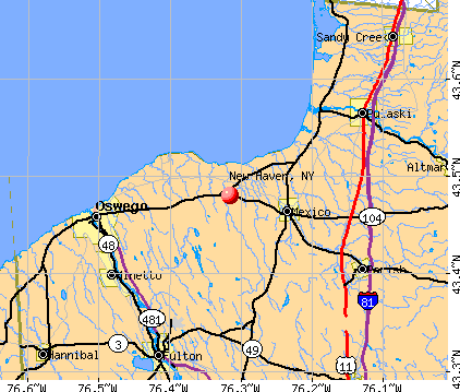
- OSM Map
- General Map
- Google Map
- MSN Map
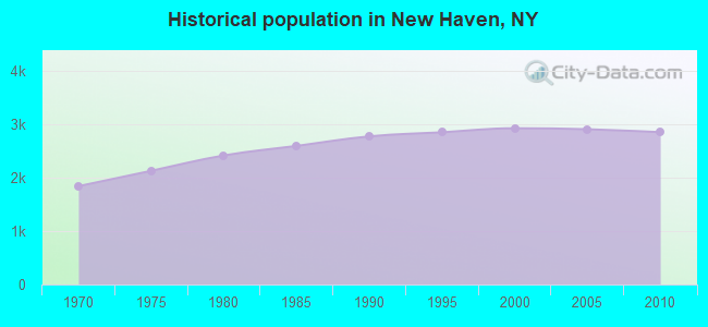
Population change since 2000: -2.5%
 |
| Males: 1,443 | |
| Females: 1,413 |
| Median resident age: | 40.0 years |
| New York median age: | 40.7 years |
Zip codes: 13114.
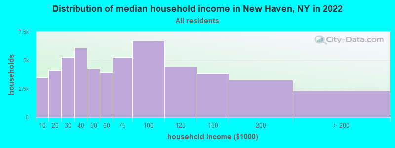
| New Haven: | $64,989 |
| NY: | $79,557 |
Estimated per capita income in 2022: $33,069 (it was $16,957 in 2000)
New Haven town income, earnings, and wages data
Estimated median house or condo value in 2022: $129,585 (it was $64,700 in 2000)
| New Haven: | $129,585 |
| NY: | $400,400 |
Mean prices in 2022: all housing units: $171,234; detached houses: $187,738; townhouses or other attached units: $467,987; in 2-unit structures: $241,662; in 3-to-4-unit structures: $129,857; in 5-or-more-unit structures: $423,366; mobile homes: $64,434; occupied boats, rvs, vans, etc.: $95,273
Detailed information about poverty and poor residents in New Haven, NY
Compare current foreclosures near New Haven, NY:
| Photo | Address | Area | Beds / Baths | Price | Details |
|---|---|---|---|---|---|

|
#1
Lake St
Pulaski, NY 13142
|
1,416 sq. feet
|
1 baths 3 beds |
show details | |

|
#2
State Route 69a
Parish, NY 13131
|
1,600 sq. feet
|
2 baths 3 beds |
show details | |

|
#3
Hickory Grove Dr
Oswego, NY 13126
|
2,360 sq. feet
|
2 baths 4 beds |
show details | |

|
#4
E 9th St
Oswego, NY 13126
|
1,422 sq. feet
|
1 baths 3 beds |
show details | |

|
#5
E Broadway
Fulton, NY 13069
|
1,440 sq. feet
|
1 baths 3 beds |
show details | |

|
#6
County Route 1
Oswego, NY 13126
|
1,280 sq. feet
|
1 baths 3 beds |
show details | |

|
#7
W Myers Rd
Oswego, NY 13126
|
816 sq. feet
|
1 baths 2 beds |
show details | |

|
#8
Ontario St
Oswego, NY 13126
|
1,093 sq. feet
|
1 baths 2 beds |
show details | |

|
#9
Singleton St
Oswego, NY 13126
|
1,150 sq. feet
|
1 baths 4 beds |
show details | |

|
#10
Delano St # B
Pulaski, NY 13142
|
1,580 sq. feet
|
1 baths 3 beds |
show details |
| Photo | Address | Area | Beds / Baths | Price | Details |
|---|---|---|---|---|---|

|
#11
State Route 104
Parish, NY 13131
|
1,300 sq. feet
|
2 baths 3 beds |
show details | |

|
#12
County Route 33
Central Square, NY 13036
|
1,456 sq. feet
|
2 baths 3 beds |
show details | |

|
#13
State Route 104
Parish, NY 13131
|
1,248 sq. feet
|
2 baths 3 beds |
show details | |

|
#14
Us Route 11
Hastings, NY 13076
|
1,215 sq. feet
|
1 baths 3 beds |
show details | |

|
#15
N 5th St
Fulton, NY 13069
|
2,362 sq. feet
|
2 baths 4 beds |
show details | |

|
#16
Highland St
Fulton, NY 13069
|
1,322 sq. feet
|
1 baths 3 beds |
show details | |

|
#17
Rocking Horse Rd
Pulaski, NY 13142
|
630 sq. feet
|
1 baths 2 beds |
show details | |

|
#18
Fay St
Fulton, NY 13069
|
1,524 sq. feet
|
2 baths 3 beds |
show details | |

|
#19
W 5th St S
Fulton, NY 13069
|
4,458 sq. feet
|
3 baths 5 beds |
show details | |

|
#20
Leitch St
Fulton, NY 13069
|
1,366 sq. feet
|
1 baths 4 beds |
show details |
| Photo | Address | Area | Beds / Baths | Price | Details |
|---|---|---|---|---|---|

|
#21
County Route 89
Oswego, NY 13126
|
1,724 sq. feet
|
1 baths 2 beds |
show details | |

|
#22
Smith Rd
Central Square, NY 13036
|
1,248 sq. feet
|
1 baths 3 beds |
show details | |

|
#23
Tug Hill Rd
Oswego, NY 13126
|
2,009 sq. feet
|
1 baths 3 beds |
show details | |

|
#24
Godfrey Rd
Pennellville, NY 13132
|
1,904 sq. feet
|
1 baths 3 beds |
show details | |

|
#25
Shanty Creek Rd
Central Square, NY 13036
|
2,346 sq. feet
|
2 baths 4 beds |
show details | |

|
#26
County Route 32 # 32
Mallory, NY 13103
|
2,780 sq. feet
|
1 baths 2 beds |
show details | |

|
#27
Muck Dr
Hannibal, NY 13074
|
1,620 sq. feet
|
2 baths 3 beds |
show details | |

|
#28
Dylan Dr
Central Square, NY 13036
|
2,064 sq. feet
|
2 baths 4 beds |
show details | |

|
#29
Wart Rd
Lacona, NY 13083
|
1,404 sq. feet
|
2 baths 3 beds |
show details | |

|
#30
County Route 7
Hannibal, NY 13074
|
960 sq. feet
|
1 baths 3 beds |
show details |
| Photo | Address | Area | Beds / Baths | Price | Details |
|---|---|---|---|---|---|

|
#31
Sharp Rd
Fulton, NY 13069
|
1,344 sq. feet
|
2 baths 3 beds |
show details | |

|
#32
S Granby Rd
Fulton, NY 13069
|
1,768 sq. feet
|
1 baths 3 beds |
show details | |

|
#33
Jackson Rd
Central Square, NY 13036
|
1,968 sq. feet
|
2 baths 3 beds |
show details | |

|
#34
Spaulsbury Rd
West Monroe, NY 13167
|
1,728 sq. feet
|
1 baths 3 beds |
show details | |

|
#35
E Van Buren St
Oswego, NY 13126
|
2,531 sq. feet
|
2 baths 4 beds |
show details | |

|
#36
State Route 48
Oswego, NY 13126
|
2,457 sq. feet
|
2 baths 6 beds |
show details | |

|
#37
Chestnut St
Oswego, NY 13126
|
1,127 sq. feet
|
2 baths 3 beds |
show details | |

|
#38
County Route 16
Mexico, NY 13114
|
1,248 sq. feet
|
1 baths 3 beds |
show details | |

|
#39
County Route 4
Oswego, NY 13126
|
1,512 sq. feet
|
1 baths 3 beds |
show details | |

|
#40
E 2nd St
Oswego, NY 13126
|
1,697 sq. feet
|
1 baths 3 beds |
show details |
| Photo | Address | Area | Beds / Baths | Price | Details |
|---|---|---|---|---|---|

|
#41
County Route 57
Oswego, NY 13126
|
1,696 sq. feet
|
1 baths 3 beds |
show details | |

|
#42
Duer St
Oswego, NY 13126
|
950 sq. feet
|
1 baths 2 beds |
show details | |

|
#43
E Oneida St
Oswego, NY 13126
|
3,056 sq. feet
|
3 baths 5 beds |
show details | |

|
#44
State Route 3
Central Square, NY 13036
|
1,350 sq. feet
|
1 baths 2 beds |
show details | |

|
#45
State Route 48
Fulton, NY 13069
|
1,222 sq. feet
|
1 baths 3 beds |
show details | |

|
#46
East, D 2
Oswego, NY 13126
|
1,540 sq. feet
|
1 baths 3 beds |
show details | |

|
#47
N Fernwood Rd
Pulaski, NY 13142
|
964 sq. feet
|
2 baths 2 beds |
show details | |

|
#48
County Route 4
Central Square, NY 13036
|
1,320 sq. feet
|
1 baths 3 beds |
show details | |

|
#49
E Cayuga St
Oswego, NY 13126
|
1,288 sq. feet
|
1 baths 3 beds |
show details | |

|
Check over 1 million property listings on Foreclosure.com!
|
browse all offers | |||

- 2,77397.1%White alone
- 371.3%Hispanic
- 210.7%Two or more races
- 120.4%Asian alone
- 70.2%Black alone
- 40.1%American Indian alone
- 20.07%Other race alone
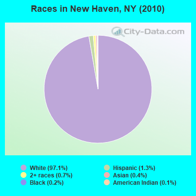
Races in New Haven detailed stats: ancestries, foreign born residents, place of birth
 Recent articles from our blog. Our writers, many of them Ph.D. graduates or candidates, create easy-to-read articles on a wide variety of topics.


Latest news from New Haven, NY collected exclusively by city-data.com from local newspapers, TV, and radio stations
Ancestries: English (17.8%), German (13.3%), Irish (13.0%), United States (12.4%), French (9.1%), Italian (7.6%).
Current Local Time: EST time zone
Elevation: 418 feet
Land area: 31.2 square miles.
Population density: 92 people per square mile (very low).
43 residents are foreign born
| This town: | 1.5% |
| New York: | 20.4% |
| New Haven town: | 2.5% ($1,641) |
| New York: | 1.9% ($2,847) |
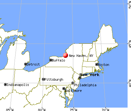
Nearest city with pop. 50,000+: Clay, NY  (23.7 miles , pop. 58,805).
Nearest city with pop. 200,000+: Rochester, NY (69.1 miles , pop. 219,773).
Nearest city with pop. 1,000,000+: Bronx, NY (221.0 miles , pop. 1,332,650).
Nearest cities:
), ), ), ), )Latitude: 43.48 N, Longitude: 76.31 W
Area code commonly used in this area: 315

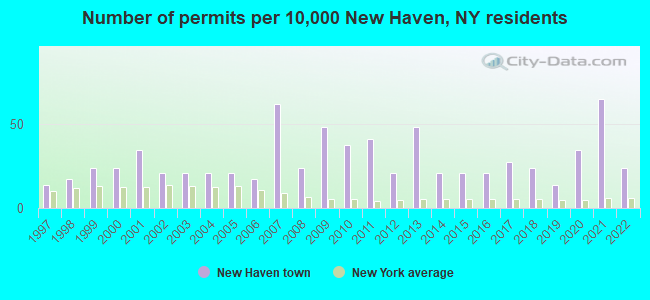
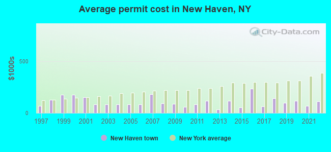
Single-family new house construction building permits:
- 2022: 7 buildings, average cost: $114,300
- 2021: 19 buildings, average cost: $66,200
- 2020: 10 buildings, average cost: $117,800
- 2019: 4 buildings, average cost: $97,500
- 2018: 7 buildings, average cost: $140,400
- 2017: 8 buildings, average cost: $63,900
- 2016: 6 buildings, average cost: $232,500
- 2015: 6 buildings, average cost: $53,300
- 2014: 6 buildings, average cost: $115,800
- 2013: 14 buildings, average cost: $33,300
- 2012: 6 buildings, average cost: $118,200
- 2011: 12 buildings, average cost: $83,300
- 2010: 11 buildings, average cost: $57,900
- 2009: 14 buildings, average cost: $89,300
- 2008: 7 buildings, average cost: $94,400
- 2007: 18 buildings, average cost: $180,000
- 2006: 5 buildings, average cost: $82,500
- 2005: 6 buildings, average cost: $82,500
- 2004: 6 buildings, average cost: $82,500
- 2003: 6 buildings, average cost: $82,500
- 2002: 6 buildings, average cost: $82,500
- 2001: 10 buildings, average cost: $149,900
- 2000: 7 buildings, average cost: $175,700
- 1999: 7 buildings, average cost: $175,700
- 1998: 5 buildings, average cost: $126,000
- 1997: 4 buildings, average cost: $68,000
| Here: | 5.1% |
| New York: | 4.4% |
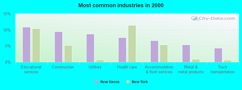
- Educational services (10.9%)
- Construction (9.5%)
- Utilities (8.8%)
- Health care (7.6%)
- Accommodation & food services (6.7%)
- Metal & metal products (5.4%)
- Truck transportation (4.4%)
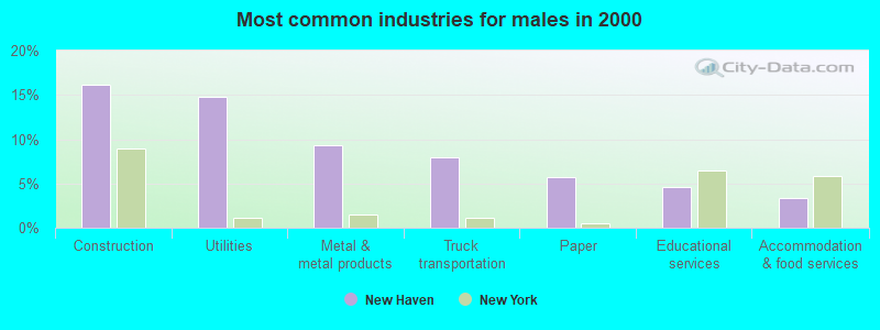
- Construction (16.1%)
- Utilities (14.7%)
- Metal & metal products (9.3%)
- Truck transportation (8.0%)
- Paper (5.8%)
- Educational services (4.6%)
- Accommodation & food services (3.4%)
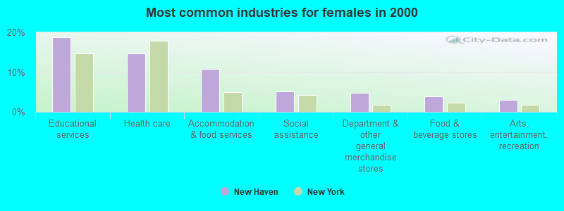
- Educational services (18.7%)
- Health care (14.7%)
- Accommodation & food services (10.7%)
- Social assistance (5.2%)
- Department & other general merchandise stores (4.9%)
- Food & beverage stores (3.8%)
- Arts, entertainment, recreation (2.9%)
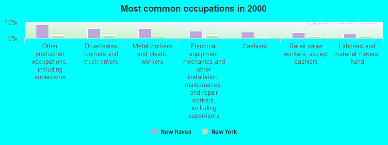
- Other production occupations, including supervisors (8.4%)
- Driver/sales workers and truck drivers (6.2%)
- Metal workers and plastic workers (6.0%)
- Electrical equipment mechanics and other installation, maintenance, and repair workers, including supervisors (4.4%)
- Cashiers (4.0%)
- Retail sales workers, except cashiers (3.6%)
- Laborers and material movers, hand (2.9%)
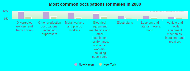
- Driver/sales workers and truck drivers (11.2%)
- Other production occupations, including supervisors (10.9%)
- Metal workers and plastic workers (9.7%)
- Electrical equipment mechanics and other installation, maintenance, and repair workers, including supervisors (8.0%)
- Electricians (4.8%)
- Laborers and material movers, hand (4.6%)
- Vehicle and mobile equipment mechanics, installers, and repairers (3.1%)

- Cashiers (8.5%)
- Retail sales workers, except cashiers (6.4%)
- Preschool, kindergarten, elementary, and middle school teachers (5.2%)
- Other production occupations, including supervisors (5.2%)
- Secretaries and administrative assistants (5.0%)
- Nursing, psychiatric, and home health aides (4.7%)
- Other teachers, instructors, education, training, and library occupations (4.7%)
Average climate in New Haven, New York
Based on data reported by over 4,000 weather stations


Earthquake activity:
New Haven-area historical earthquake activity is significantly above New York state average. It is 69% smaller than the overall U.S. average.On 10/7/1983 at 10:18:46, a magnitude 5.3 (5.1 MB, 5.3 LG, 5.1 ML, Class: Moderate, Intensity: VI - VII) earthquake occurred 103.6 miles away from the city center
On 4/20/2002 at 10:50:47, a magnitude 5.3 (5.3 ML, Depth: 3.0 mi) earthquake occurred 148.2 miles away from New Haven center
On 4/20/2002 at 10:50:47, a magnitude 5.2 (5.2 MB, 4.2 MS, 5.2 MW, 5.0 MW) earthquake occurred 146.5 miles away from New Haven center
On 9/25/1998 at 19:52:52, a magnitude 5.2 (4.8 MB, 4.3 MS, 5.2 LG, 4.5 MW, Depth: 3.1 mi) earthquake occurred 249.8 miles away from New Haven center
On 8/23/2011 at 17:51:04, a magnitude 5.8 (5.8 MW, Depth: 3.7 mi) earthquake occurred 394.8 miles away from New Haven center
On 6/17/1991 at 08:53:16, a magnitude 4.1 (4.0 MB, 4.0 LG, Depth: 3.1 mi, Class: Light, Intensity: IV - V) earthquake occurred 101.4 miles away from New Haven center
Magnitude types: regional Lg-wave magnitude (LG), body-wave magnitude (MB), local magnitude (ML), surface-wave magnitude (MS), moment magnitude (MW)
Natural disasters:
The number of natural disasters in Oswego County (16) is near the US average (15).Major Disasters (Presidential) Declared: 7
Emergencies Declared: 7
Causes of natural disasters: Floods: 6, Storms: 3, Hurricanes: 2, Snows: 2, Winds: 2, Blizzard: 1, Heavy Rain: 1, Ice Storm: 1, Landslide: 1, Power Outage: 1, Tropical Storm: 1, Other: 2 (Note: some incidents may be assigned to more than one category).
Hospitals and medical centers near New Haven:
- OSWEGO CO HLTH DIV NURSNG CHHA (Home Health Center, about 10 miles away; OSWEGO, NY)
- OSWEGO COUNTY HOSPICE (Hospital, about 10 miles away; OSWEGO, NY)
- PONTIAC NURSING HOME (Nursing Home, about 10 miles away; OSWEGO, NY)
- ST LUKE HEALTH SERVICES (Nursing Home, about 10 miles away; OSWEGO, NY)
- LORETTO-OSWEGO HEALTH AND REHAB CENTER (Nursing Home, about 11 miles away; OSWEGO, NY)
- MORNINGSTAR RESIDENTIAL CARE CENTER (Nursing Home, about 12 miles away; OSWEGO, NY)
- HOSPITALS HOME HEALTH CARE HHA (Home Health Center, about 13 miles away; FULTON, NY)
Operable nuclear power plants near New Haven:
- 6 miles: James A. FitzPatrick in Scriba, NY.
- 6 miles: Nine Mile Point 1 and 2 in Scriba, NY.
Colleges/universities with over 2000 students nearest to New Haven:
- SUNY College at Oswego (about 12 miles; Oswego, NY; Full-time enrollment: 7,550)
- Syracuse University (about 32 miles; Syracuse, NY; FT enrollment: 20,717)
- Le Moyne College (about 33 miles; Syracuse, NY; FT enrollment: 3,041)
- SUNY College of Environmental Science and Forestry (about 33 miles; Syracuse, NY; FT enrollment: 2,044)
- Onondaga Community College (about 34 miles; Syracuse, NY; FT enrollment: 8,920)
- Cayuga County Community College (about 40 miles; Auburn, NY; FT enrollment: 3,141)
- Jefferson Community College (about 40 miles; Watertown, NY; FT enrollment: 2,886)
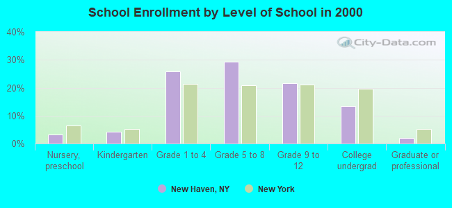
Public elementary/middle school in New Haven:
- NEW HAVEN ELEMENTARY SCHOOL (Students: 219, Location: 4320 STATE RT 104, Grades: PK-4)
Points of interest:
Notable locations in New Haven: Behling Orchards (A), Johnson Corners (B), New Haven Station (C), Demster Grove Camp Ground (D), Butterfly Corners (E), Austins Corners (F), Cummings Bridge (G). Display/hide their locations on the map
Churches in New Haven include: Community Alliance Church (A), First Congregational Church (B), New Haven United Methodist Church (C). Display/hide their locations on the map
Cemeteries: Vermilion Cemetery (1), Butterfly Cemetery (2), New Haven Rural Cemetery (3). Display/hide their locations on the map
Lakes and swamps: Lily Pond (A), Mud Pond (B), Lily Marsh (C), Butterfly Swamp (D). Display/hide their locations on the map
Creek: Butterfly Creek (A). Display/hide its location on the map
Hotel: Catfish Creek Fishing Camp (118 Chase Drive) (1). Display/hide its approximate location on the map
Birthplace of: John F. Kinney - Politician.
| This town: | 2.6 people |
| New York: | 2.6 people |
| This town: | 74.4% |
| Whole state: | 63.5% |
| This town: | 10.2% |
| Whole state: | 6.8% |
Likely homosexual households (counted as self-reported same-sex unmarried-partner households)
- Lesbian couples: 0.3% of all households
- Gay men: 0.2% of all households
| This town: | 11.3% |
| Whole state: | 14.6% |
| This town: | 5.2% |
| Whole state: | 7.4% |
For population 15 years and over in New Haven:
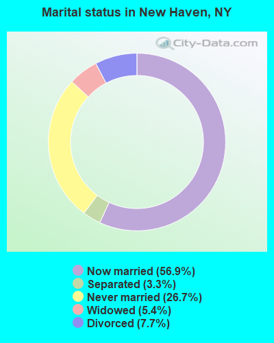
- Never married: 26.7%
- Now married: 56.9%
- Separated: 3.3%
- Widowed: 5.4%
- Divorced: 7.7%
For population 25 years and over in New Haven:
- High school or higher: 83.4%
- Bachelor's degree or higher: 11.6%
- Graduate or professional degree: 3.5%
- Unemployed: 7.3%
- Mean travel time to work (commute): 26.7 minutes

| Here: | 8.1 |
| New York average: | 14.2 |
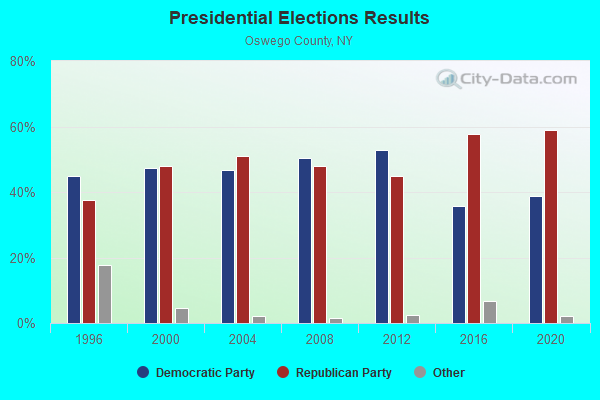
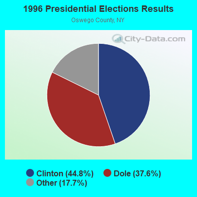
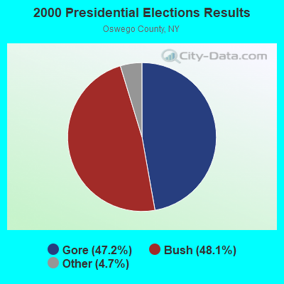
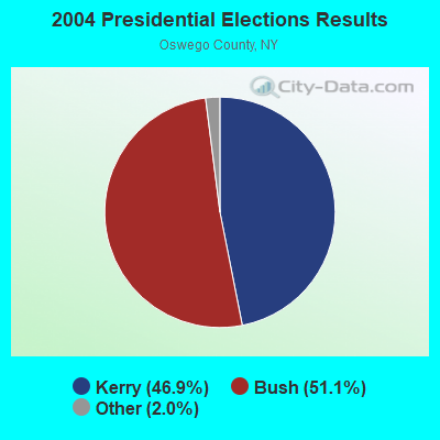
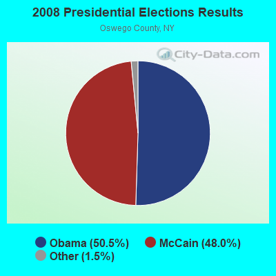
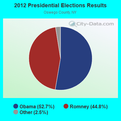

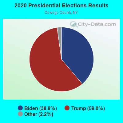
Graphs represent county-level data. Detailed 2008 Election Results
Religion statistics for New Haven, NY (based on Oswego County data)
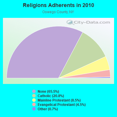
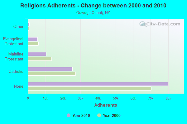
| Religion | Adherents | Congregations |
|---|---|---|
| Catholic | 25,395 | 17 |
| Mainline Protestant | 10,408 | 60 |
| Evangelical Protestant | 5,504 | 53 |
| Other | 860 | 6 |
| None | 79,942 | - |
Food Environment Statistics:
| Here: | 2.06 / 10,000 pop. |
| New York: | 4.13 / 10,000 pop. |
| This county: | 0.08 / 10,000 pop. |
| State: | 0.06 / 10,000 pop. |
| Here: | 0.49 / 10,000 pop. |
| State: | 0.92 / 10,000 pop. |
| Here: | 4.03 / 10,000 pop. |
| New York: | 1.68 / 10,000 pop. |
| Oswego County: | 7.08 / 10,000 pop. |
| New York: | 8.82 / 10,000 pop. |
| This county: | 8.5% |
| New York: | 8.2% |
| Oswego County: | 27.7% |
| State: | 23.8% |
| This county: | 14.8% |
| New York: | 15.6% |
Strongest AM radio stations in New Haven:
- WSCP (1070 AM; daytime; 2 kW; SANDY CREEK-PULASKI, NY; Owner: GALAXY COMMUNICATIONS, L.P.)
- WHEN (620 AM; 5 kW; SYRACUSE, NY; Owner: CLEAR CHANNEL BROADCASTING LICENSES, INC.)
- WSGO (1440 AM; 1 kW; OSWEGO, NY; Owner: GALAXY COMMUNICATIONS, L.P.)
- WHAM (1180 AM; 50 kW; ROCHESTER, NY; Owner: CITICASTERS LICENSES, L.P.)
- WDCW (1390 AM; 5 kW; SYRACUSE, NY; Owner: KIMTRON, INC.)
- WSYR (570 AM; 5 kW; SYRACUSE, NY; Owner: CLEAR CHANNEL BROADCASTING LICENSES, INC.)
- WFBL (1050 AM; 2 kW; BALDWINSVILLE, NY; Owner: BUCKLEY BROADCASTING CORPORATION)
- WGY (810 AM; 50 kW; SCHENECTADY, NY; Owner: CLEAR CHANNEL BROADCASTING LICENSES, INC.)
- WAMF (1300 AM; 1 kW; FULTON, NY; Owner: DONALD H. DEROSA)
- WNSS (1260 AM; 5 kW; SYRACUSE, NY; Owner: CITADEL BROADCASTING COMPANY)
- WNER (1410 AM; 5 kW; WATERTOWN, NY)
- WPTR (1540 AM; 50 kW; ALBANY, NY; Owner: KIMTRON, INC.)
- WNNZ (640 AM; 50 kW; WESTFIELD, MA; Owner: CLEAR CHANNEL BROADCASTING LICENSES, INC.)
Strongest FM radio stations in New Haven:
- WVOA-FM (103.9 FM; MEXICO, NY; Owner: RENARD COMMUNICATIONS CORP.)
- WOLF-FM (96.7 FM; OSWEGO, NY; Owner: WOLF RADIO, INC.)
- WTKV (105.5 FM; OSWEGO, NY; Owner: GALAXY COMMUNICATIONS, L.P.)
- WKRH (106.5 FM; MINETTO, NY; Owner: GALAXY COMMUNICATIONS, L.P.)
- WRVO (89.9 FM; OSWEGO, NY; Owner: STATE UNIVERSITY OF NEW YORK)
- WBBS (104.7 FM; FULTON, NY; Owner: CITICASTERS LICENSES, L.P.)
- WBDI (106.7 FM; COPENHAGEN, NY; Owner: FORCE COMMUNICATIONS, INC)
- WJNY (90.9 FM; WATERTOWN, NY; Owner: PUBLIC B/CNG COUNCIL CENTRAL NY, INC)
- WSCP-FM (101.7 FM; PULASKI, NY; Owner: GALAXY COMMUNICATIONS, L.P.)
- WFRY-FM (97.5 FM; WATERTOWN, NY; Owner: REGENT LICENSEE OF WATERTOWN, INC.)
- WMHR (102.9 FM; SYRACUSE, NY; Owner: MARS HILL BROADCASTING CO., INC.)
- WSEN-FM (92.1 FM; BALDWINSVILLE, NY; Owner: BUCKLEY BROADCASTING CORPORATION)
- WZUN (102.1 FM; PHOENIX, NY; Owner: GALAXY COMMUNICATIONS, L.P.)
TV broadcast stations around New Haven:
- WSPX-TV (Channel 56; SYRACUSE, NY; Owner: PAXSON SYRACUSE LICENSE, INC.)
- WCNY-TV (Channel 24; SYRACUSE, NY; Owner: PUBLIC BROADCASTING COUNCIL OF CENTRAL NEW YORK)
- WIXT-TV (Channel 9; SYRACUSE, NY; Owner: CENTRAL NY NEWS, INC.)
- WSTM-TV (Channel 3; SYRACUSE, NY; Owner: WSTM LICENSE SUBSIDIARY, INC.)
- WNYS-TV (Channel 43; SYRACUSE, NY; Owner: RKM MEDIA, INC.)
- WWTI (Channel 50; WATERTOWN, NY; Owner: CENTRAL NY NEWS, INC.)
- WPBS-TV (Channel 16; WATERTOWN, NY; Owner: ST. LAWRENCE VALLEY EDUCATIONAL TV COUNCIL, INC)
- WSYT (Channel 68; SYRACUSE, NY; Owner: WSYT LICENSEE L.P.)
- National Bridge Inventory (NBI) Statistics
- 10Number of bridges
- 49ft / 15.2mTotal length
- $8,229,000Total costs
- 13,121Total average daily traffic
- 885Total average daily truck traffic
- 17,297Total future (year 2036) average daily traffic
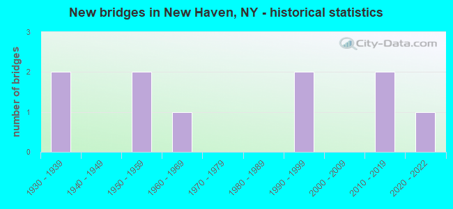
- New bridges - historical statistics
- 21930-1939
- 21950-1959
- 11960-1969
- 21990-1999
- 22010-2019
- 12020-2022
FCC Registered Cell Phone Towers:
1- New Haven Cell Site: 4277 Route #104, Behind The New Haven Town Hall (Lat: 43.477806 Lon: -76.317250), Type: Tower, Structure height: 55.2 m, Overall height: 58.2 m, Call Sign: KNKA238
Assigned Frequencies: 880.020 MHz, 835.020 MHz, 891.510 MHz, 846.510 MHz, 880.020 MHz, 880.020 MHz, 835.020 MHz, 835.020 MHz, 891.510 MHz, 891.510 MHz, 846.510 MHz, 846.510 MHzGrant Date: 04/14/2015, Expiration Date: 05/15/2025, Certifier: Gregory M RomanoRegistrant: Verizon, 1300 I Street Nw - Suite 500 East, Washington, DC 20005, Phone: (202) 515-2453, Email:
FCC Registered Antenna Towers:
2- Craig Fox, Lee & Tollgate Rd (Lat: 43.476667 Lon: -76.278611), Type: 105.2, Structure height: 36075 m, Overall height: 105.2 m, Registrant: Corneys Electronics Inc, Orisk-any, Phone: (315) 736-3061
- Lee & Tollgate Rd (Lat: 43.476667 Lon: -76.278611), Type: 105.2, Overall height: 105.2 m, Registrant: Corneys Electronics Inc, Orisk-any, Phone: (315) 736-3061
FCC Registered Private Land Mobile Towers:
2- Off Cty 43 Near Int Of Rt 104 (Lat: 43.476722 Lon: -76.278556), Type: Tower, Structure height: 105 m, Call Sign: WPDQ369,
Assigned Frequencies: 929.612 MHz, Grant Date: 12/27/2000, Expiration Date: 08/22/2010, Cancellation Date: 06/28/2001, Registrant: Paging Network Of America, Inc., 1500 International Pkwy, Suite 300, Richardson, TX 75081, Phone: (972) 801-0304, Fax: (972) 801-0330
- Off Cty 43 Nr Int Of Rt 104 (Lat: 43.476722 Lon: -76.278556), Structure height: 105 m, Call Sign: WPDQ371,
Assigned Frequencies: 929.962 MHz, Grant Date: 10/29/1998, Expiration Date: 10/29/2008, Cancellation Date: 12/20/2008, Certifier: Paul H Kuzia, Registrant: Latham & Watkins LLP, 555 Eleventh Street, N.W., Suite 1000, Washington, DC 20004, Phone: (202) 637-1095, Fax: (202) 637-2201, Email:
FCC Registered Broadcast Land Mobile Towers:
5- Fire Station Rt 104 (Lat: 43.478389 Lon: -76.309944), Call Sign: KUN534, Licensee ID: L00099832,
Assigned Frequencies: 46.1000 MHz, Grant Date: 08/02/2002, Expiration Date: 09/14/2012, Cancellation Date: 11/17/2012, Registrant: County Of Oswego, 200 North Second Street, Fulton, NY 13069, Phone: (315) 591-9142
- Hwy Garage (Lat: 43.479222 Lon: -76.317167), Call Sign: KNJD741,
Assigned Frequencies: 159.195 MHz, Grant Date: 02/25/2014, Expiration Date: 05/01/2024, Registrant: Universal Licensing Service, 4401-A Connecticut Ave Nw #232, Washington, DC 20008, Phone: (877) 677-3639, Fax: (949) 209-3097, Email:
- Toll Gate Rd (Lat: 43.476722 Lon: -76.278556), Call Sign: KNFE968, Licensee ID: L00112513,
Assigned Frequencies: 463.250 MHz, Grant Date: 02/26/2002, Expiration Date: 03/11/2012, Cancellation Date: 05/12/2012, Registrant: Corneys Electronics Inc, 185 Clear Rd, Oriskany, NY 13424
- Toll Gate Rd (Lat: 43.476722 Lon: -76.278556), Call Sign: KNFH659, Licensee ID: L00112523,
Assigned Frequencies: 463.700 MHz, Grant Date: 03/16/2002, Expiration Date: 04/03/2012, Cancellation Date: 06/09/2012, Registrant: Midstate C & E Inc, 185 Clear Rd, Oriskany, NY 13424, Phone: (315) 736-3061
- Toll Gate Rd (Lat: 43.476722 Lon: -76.278556), Call Sign: KNAX589, Licensee ID: L00059034,
Assigned Frequencies: 451.825 MHz, Grant Date: 04/23/1996, Expiration Date: 05/28/2001, Cancellation Date: 07/29/2001, Registrant: Northern Aggrigates Inc, 32 Silk Rd, Fulton, NY 13069, Phone: (315) 598-2141
FCC Registered Microwave Towers:
1- NewHaven/Copenhagen, Lee And Tollgate Rds (Lat: 43.476667 Lon: -76.278611), Type: Tower, Structure height: 105.2 m, Call Sign: WHS460,
Assigned Frequencies: 951.000 MHz, Grant Date: 01/14/1987, Expiration Date: 06/01/2022, Cancellation Date: 06/03/2014, Registrant: Public Broadcasting Council Of Central New York, Syracuse, NY 13220-2400, Phone: (315) 453-2424, Fax: (315) 451-8824, Email:
FCC Registered Amateur Radio Licenses:
2- Call Sign: AB0AE, Licensee ID: L00125080, Grant Date: 02/12/2008, Expiration Date: 05/07/2018, Cancellation Date: 07/24/2009, Registrant: Jacob F Ringwald, 235 Darrow Road, New Haven, NY 13121-0197
- Call Sign: NQ2RP, Previous Call Sign: AB0AE, Licensee ID: L00125080, Grant Date: 05/07/2019, Expiration Date: 07/24/2029, Certifier: Jacob F Ringwald, Registrant: Jacob F Ringwald, 235 Darrow Road, New Haven, NY 13121
2002 - 2018 National Fire Incident Reporting System (NFIRS) incidents
- Fire incident types reported to NFIRS in New Haven, NY
- 16665.1%Structure Fires
- 5722.4%Outside Fires
- 228.6%Mobile Property/Vehicle Fires
- 103.9%Other
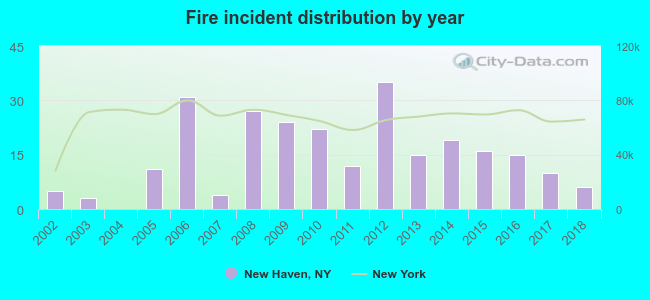 According to the data from the years 2002 - 2018 the average number of fire incidents per year is 15. The highest number of reported fires - 35 took place in 2012, and the least - 0 in 2004. The data has an increasing trend.
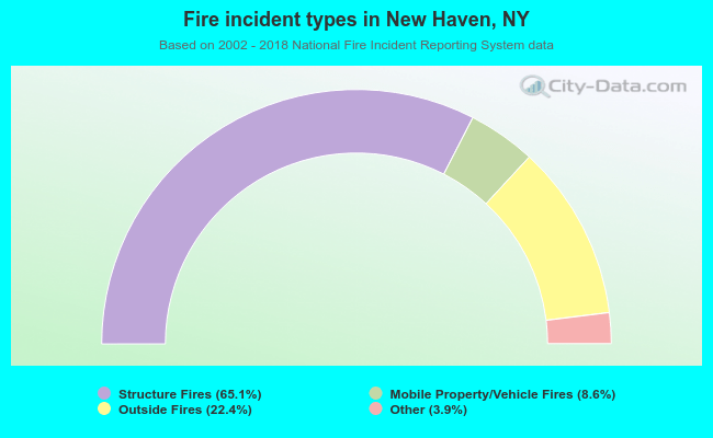 When looking into fire subcategories, the most incidents belonged to: Structure Fires (65.1%), and Outside Fires (22.4%).
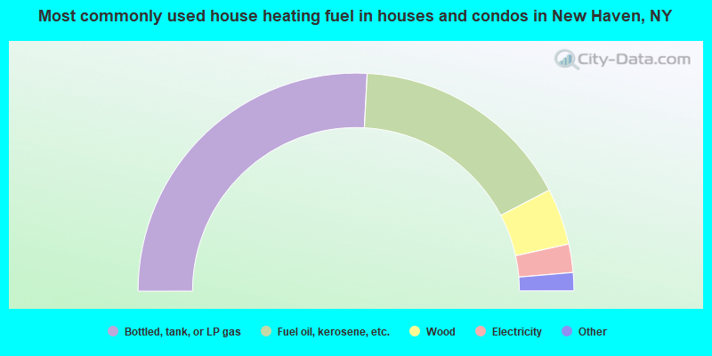
- 51.6%Bottled, tank, or LP gas
- 33.0%Fuel oil, kerosene, etc.
- 8.4%Wood
- 4.2%Electricity
- 1.4%Other fuel
- 0.9%Coal or coke
- 0.5%Utility gas
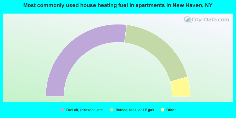
- 53.8%Fuel oil, kerosene, etc.
- 37.4%Bottled, tank, or LP gas
- 2.7%Utility gas
- 2.7%Wood
- 1.6%Electricity
- 1.6%Other fuel
New Haven compared to New York state average:
- Median house value significantly below state average.
- Unemployed percentage below state average.
- Black race population percentage significantly below state average.
- Hispanic race population percentage significantly below state average.
- Foreign-born population percentage significantly below state average.
- Renting percentage significantly below state average.
- Length of stay since moving in significantly above state average.
- Number of rooms per house significantly below state average.
- House age significantly below state average.
- Percentage of population with a bachelor's degree or higher significantly below state average.