Bridge Statistics for New Haven, New York (NY)
Condition, Traffic, Stress, Structural Evaluation, Project Costs
- National Bridge Inventory (NBI) Statistics
- 10Number of bridges
- 49ft / 15.2mTotal length
- $8,229,000Total costs
- 13,121Total average daily traffic
- 885Total average daily truck traffic
- 17,297Total future (year 2036) average daily traffic
- National Bridge Inventory (NBI) Registered Bridges for New Haven
- No street view available for this location
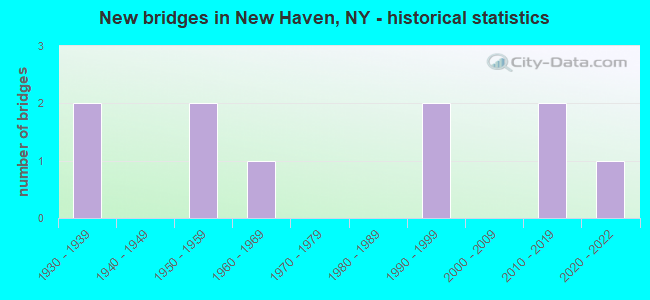
- New bridges - historical statistics
- 21930-1939
- 21950-1959
- 11960-1969
- 21990-1999
- 22010-2019
- 12020-2022

- Reconstructed bridges - Historical Statistics
- 11990-1999
- 02000-2009
- 12010-2019

- Bridge Condition - Deck
- 28.6%Excellent
- 14.3%Very good
- 28.6%Good
- 14.3%Satisfactory
- 14.3%Fair

- Bridge Condition - Superstructure
- 42.9%Excellent
- 14.3%Very good
- 14.3%Good
- 14.3%Fair
- 14.3%Serious

- Bridge Condition - Substructure
- 14.3%Excellent
- 28.6%Very good
- 14.3%Good
- 14.3%Satisfactory
- 14.3%Fair
- 14.3%Poor

- Bridge Condition - Channel
- 10.0%Very good
- 40.0%Good
- 30.0%Satisfactory
- 20.0%Fair
Find on map >> Show street view
Structure Number: 103661, Location: 0.3 MI E JCT RTS 104+104B (Lat: 43.479378, Lng: -76.325167), Route carried "on" structure: State highway 104, Year Built: 2010, Status: Open, Structure Length: 3.44m (11.29ft), Average Daily Traffic: 2,899 (year 2020), Truck Traffic: 10%, Average Future Daily Traffic: 2,997 (year 2040), Design Load: HL 93, Features Intersected: CATFISH CREEK
Minimum Vertical Clearance: 30+ m (98+ ft), Kilometerpoint: 38.214, Lanes on structure: 2, Base Highway Network: Yes, Owner: State Highway Agency, Approaching Roadway Width: 11.9m (39.0ft), Material/Design: Steel, Design/Construction: Stringer/Multi-beam, Number Of Spans In Main Unit: 1, Length of Maximum Span: 34.0m (111.5ft), Curb-To-Curb Width: 12.0m (39.4ft), Out-to-Out Width: 13.0m (42.7ft)
Condition: Deck: Good, Superstructure: Very good, Substructure: Very good, Channel: Very good, Operating Rating: 86.0 metric tons, Method Used To Determine Operating Rating: Load Factor (LF), Inventory Rating: 51.0 metric tons, Method Used To Determine Inventory Rating: Load Factor (LF), Structural Evaluation: Equal to present desirable criteria, Deck Geometry: Somewhat better than minimum adequacy, Waterway Adequacy: Equal to present desirable criteria, Approach Roadway Alignment: Meets minimum limits, Length Of Structure Improvement: 3.44m (11.29ft), Designated Inspection Frequency: Every 24 months, Inspection Date: July 2020, Bridge Improvement Cost: $1,385,000, Roadway Improvement Cost: $811,000, Total Project Cost: $2,196,000 ( Estimate for 2021), Deck Structure Type: Concrete Cast-file-Place, Wearing Surface/Protective System: Wearing Surface: Integral Concrete
Find on map >> Show street view
Structure Number: 10367, Location: 0.3MI NE JCT RTS 104B+104 (Lat: 43.483311, Lng: -76.325644), Route carried "on" structure: State highway 104B, Year Built: 1950, Year Reconstructed: 1995, Status: Open, Structure Length: 1.40m (4.59ft), Average Daily Traffic: 2,393 (year 2020), Truck Traffic: 4%, Average Future Daily Traffic: 3,345 (year 2040), Design Load: HS 25 or greater, Features Intersected: CATFISH CREEK
Minimum Vertical Clearance: 30+ m (98+ ft), Kilometerpoint: 0.644, Lanes on structure: 2, Base Highway Network: Yes, Owner: State Highway Agency, Approaching Roadway Width: 12.2m (40.0ft), Material/Design: Steel, Design/Construction: Stringer/Multi-beam, Number Of Spans In Main Unit: 1, Length of Maximum Span: 13.4m (44.0ft), Curb-To-Curb Width: 12.2m (40.0ft), Out-to-Out Width: 12.8m (42.0ft)
Condition: Deck: Very good, Superstructure: Excellent, Substructure: Satisfactory, Channel: Good, Operating Rating: 61.9 metric tons, Method Used To Determine Operating Rating: Load and Resistance Factor Rating (LRFR) rating reported by rating factor(RF) method using HL-93 loadings, Inventory Rating: 47.6 metric tons, Method Used To Determine Inventory Rating: Load and Resistance Factor Rating (LRFR) rating reported by rating factor(RF) method using HL-93 loadings, Structural Evaluation: Equal to present minimum criteria, Deck Geometry: Equal to present minimum criteria, Waterway Adequacy: Somewhat better than minimum adequacy, Approach Roadway Alignment: Equal to present desirable criteria, Length Of Structure Improvement: 1.40m (4.59ft), Designated Inspection Frequency: Every 24 months, Inspection Date: August 2021, Bridge Improvement Cost: $635,000, Roadway Improvement Cost: $372,000, Total Project Cost: $1,007,000 ( Estimate for 2021), Deck Structure Type: Concrete Cast-file-Place, Wearing Surface/Protective System: Wearing Surface: Integral Concrete, Deck Protection: Epoxy Coated Reinforcing
Find on map >> Show street view
Structure Number: 103671, Location: 2.8MI NE JCT RTS 104B+104 (Lat: 43.500978, Lng: -76.285722), Route carried "on" structure: State highway 104B, Year Built: 1950, Status: Open, Structure Length: 0.82m (2.69ft), Average Daily Traffic: 2,393 (year 2020), Truck Traffic: 4%, Average Future Daily Traffic: 3,345 (year 2040), Design Load: H 20, Features Intersected: BUTTERFLY CREEK
Minimum Vertical Clearance: 30+ m (98+ ft), Kilometerpoint: 4.441, Lanes on structure: 2, Base Highway Network: Yes, Owner: State Highway Agency, Approaching Roadway Width: 12.8m (42.0ft), Material/Design: Concrete, Design/Construction: Culvert, Number Of Spans In Main Unit: 1, Length of Maximum Span: 7.3m (24.0ft)
Condition: Channel: Fair, Culverts: Satisfactory, Operating Rating: 74.8 metric tons, Method Used To Determine Operating Rating: Field evaluation and documented engineering judgment, Inventory Rating: 32.7 metric tons, Method Used To Determine Inventory Rating: Field evaluation and documented engineering judgment, Structural Evaluation: Equal to present minimum criteria, Waterway Adequacy: Meets minimum limits, Approach Roadway Alignment: Equal to present desirable criteria, Length Of Structure Improvement: 0.82m (2.69ft), Designated Inspection Frequency: Every 24 months, Inspection Date: August 2021, Bridge Improvement Cost: $606,000, Roadway Improvement Cost: $355,000, Total Project Cost: $960,000 ( Estimate for 2021)
Find on map >> Show street view
Structure Number: 320907, Location: 4.8 MILES NW OF MEXICO (Lat: 43.478356, Lng: -76.324344), Route carried "on" structure: Other road , Year Built: 1930, Status: Posted for load, Structure Length: 1.04m (3.41ft), Average Daily Traffic: 127 (year 2019), Truck Traffic: 8%, Average Future Daily Traffic: 178 (year 2039), Features Intersected: CATFISH CREEK, Facility Carried by Structure: SOPER MILLS ROAD
Minimum Vertical Clearance: 30+ m (98+ ft), Kilometerpoint: 0.370, Lanes on structure: 2, Owner: County Highway Agency, Approaching Roadway Width: 5.2m (17.1ft), Material/Design: Concrete, Design/Construction: Tee Beam, Number Of Spans In Main Unit: 1, Length of Maximum Span: 9.7m (31.8ft), Curb-To-Curb Width: 6.2m (20.3ft), Out-to-Out Width: 6.9m (22.6ft)
Condition: Deck: Satisfactory, Superstructure: Serious, Substructure: Poor, Channel: Fair, Operating Rating: 7.3 metric tons, Method Used To Determine Operating Rating: Field evaluation and documented engineering judgment, Inventory Rating: 7.3 metric tons, Method Used To Determine Inventory Rating: Field evaluation and documented engineering judgment, Structural Evaluation: High priority of corrective action, Deck Geometry: Meets minimum limits, Waterway Adequacy: Superior to present desirable criteria, Approach Roadway Alignment: Meets minimum limits, Bridge Posting: Required (Relationship of Operating Rating to Maximum Legal Load: > 39.9% below), Length Of Structure Improvement: 1.03m (3.38ft), Designated Inspection Frequency: Every 12 months, Underwater Inspection Frequency: Every 60 months, Inspection Date: October 2021, Underwater Inspection Date: June 2017, Bridge Improvement Cost: $576,000, Roadway Improvement Cost: $337,000, Total Project Cost: $913,000 ( Estimate for 2021), Deck Structure Type: Concrete Cast-file-Place, Wearing Surface/Protective System: Wearing Surface: Bituminous
Find on map >> Show street view
Structure Number: 320908, Location: 4.2 MI W OF MEXICO (Lat: 43.461325, Lng: -76.317164), Route carried "on" structure: County highway , Year Built: 1965, Year Reconstructed: 2010, Status: Open, Structure Length: 1.16m (3.81ft), Average Daily Traffic: 235 (year 2020), Truck Traffic: 8%, Average Future Daily Traffic: 329 (year 2040), Features Intersected: CATFISH CREEK, Facility Carried by Structure: STONE ROAD
Minimum Vertical Clearance: 30+ m (98+ ft), Kilometerpoint: 0.547, Lanes on structure: 2, Owner: County Highway Agency, Approaching Roadway Width: 6.7m (22.0ft), Material/Design: Steel, Design/Construction: Stringer/Multi-beam, Number Of Spans In Main Unit: 1, Length of Maximum Span: 11.3m (37.1ft), Curb-To-Curb Width: 8.7m (28.5ft), Out-to-Out Width: 9.1m (29.9ft)
Condition: Deck: Good, Superstructure: Good, Substructure: Good, Channel: Good, Inventory Rating: 78.0 metric tons, Method Used To Determine Inventory Rating: Allowable Stress (AS), Structural Evaluation: Better than present minimum criteria, Deck Geometry: Equal to present minimum criteria, Waterway Adequacy: Equal to present desirable criteria, Approach Roadway Alignment: Equal to present minimum criteria, Length Of Structure Improvement: 1.15m (3.77ft), Designated Inspection Frequency: Every 24 months, Inspection Date: October 2020, Bridge Improvement Cost: $333,000, Roadway Improvement Cost: $195,000, Total Project Cost: $528,000 ( Estimate for 2021), Deck Structure Type: Corrugated Steel, Wearing Surface/Protective System: Wearing Surface: Bituminous
Find on map >> Show street view
Structure Number: 331337, Location: 4.0 MI NW OF MEXICO (Lat: 43.503600, Lng: -76.284917), Route carried "on" structure: Other road , Year Built: 1997, Status: Open, Structure Length: 0.94m (3.08ft), Average Daily Traffic: 1,710 (year 2016), Truck Traffic: 8%, Average Future Daily Traffic: 2,394 (year 2036), Features Intersected: BUTTERFLY CREEK, Facility Carried by Structure: NORTH ROAD
Minimum Vertical Clearance: 30+ m (98+ ft), Kilometerpoint: 16.058, Lanes on structure: 2, Owner: County Highway Agency, Approaching Roadway Width: 10.1m (33.1ft), Material/Design: Steel, Design/Construction: Culvert, Number Of Spans In Main Unit: 2, Length of Maximum Span: 4.2m (13.8ft)
Condition: Channel: Satisfactory, Culverts: Satisfactory, Operating Rating: 75.6 metric tons, Method Used To Determine Operating Rating: Field evaluation and documented engineering judgment, Inventory Rating: 40.8 metric tons, Method Used To Determine Inventory Rating: Field evaluation and documented engineering judgment, Structural Evaluation: Equal to present minimum criteria, Waterway Adequacy: Meets minimum limits, Approach Roadway Alignment: Equal to present desirable criteria, Length Of Structure Improvement: 0.94m (3.08ft), Designated Inspection Frequency: Every 24 months, Inspection Date: April 2020, Bridge Improvement Cost: $220,000, Roadway Improvement Cost: $129,000, Total Project Cost: $349,000 ( Estimate for 2021), Wearing Surface/Protective System: Wearing Surface: Bituminous
Find on map >> Show street view
Structure Number: 331344, Location: 4.0 MI SW OF MEXICO (Lat: 43.443819, Lng: -76.305803), Route carried "on" structure: County highway , Year Built: 1931, Status: Open, Structure Length: 1.31m (4.30ft), Average Daily Traffic: 723 (year 2016), Truck Traffic: 6%, Average Future Daily Traffic: 1,012 (year 2036), Design Load: HS 20, Features Intersected: CATFISH CREEK, Facility Carried by Structure: HURLBUT ROAD
Minimum Vertical Clearance: 30+ m (98+ ft), Kilometerpoint: 0.161, Lanes on structure: 2, Owner: County Highway Agency, Approaching Roadway Width: 7.0m (23.0ft), Material/Design: Concrete, Design/Construction: Arch - Deck, Number Of Spans In Main Unit: 1, Length of Maximum Span: 12.1m (39.7ft), Curb-To-Curb Width: 7.6m (24.9ft), Out-to-Out Width: 8.1m (26.6ft)
Condition: Deck: Fair, Superstructure: Fair, Substructure: Fair, Channel: Satisfactory, Operating Rating: 77.7 metric tons, Method Used To Determine Operating Rating: Field evaluation and documented engineering judgment, Inventory Rating: 19.6 metric tons, Method Used To Determine Inventory Rating: Field evaluation and documented engineering judgment, Structural Evaluation: Somewhat better than minimum adequacy, Deck Geometry: Meets minimum limits, Waterway Adequacy: Somewhat better than minimum adequacy, Approach Roadway Alignment: Equal to present minimum criteria, Length Of Structure Improvement: 1.31m (4.30ft), Designated Inspection Frequency: Every 24 months, Inspection Date: August 2020, Bridge Improvement Cost: $193,000, Roadway Improvement Cost: $113,000, Total Project Cost: $306,000 ( Estimate for 2021), Wearing Surface/Protective System: Wearing Surface: Bituminous
Find on map >> Show street view
Structure Number: 33135, Location: 4.4 MI W OF MEXICO (Lat: 43.453219, Lng: -76.312100), Route carried "on" structure: County highway , Year Built: 2020, Status: Open, Structure Length: 1.15m (3.77ft), Average Daily Traffic: 671 (year 2016), Truck Traffic: 6%, Average Future Daily Traffic: 939 (year 2036), Design Load: HS 20, Features Intersected: Catfish Creek, Facility Carried by Structure: VOLNEY ROAD
Minimum Vertical Clearance: 32.69m (107.25ft), Kilometerpoint: 24.779, Lanes on structure: 2, Owner: County Highway Agency, Approaching Roadway Width: 9.1m (29.9ft), Skew: 2 degrees, Material/Design: Steel, Design/Construction: Stringer/Multi-beam, Number Of Spans In Main Unit: 1, Length of Maximum Span: 11.5m (37.7ft), Curb-To-Curb Width: 9.0m (29.5ft), Out-to-Out Width: 9.1m (29.9ft)
Condition: Deck: Excellent, Superstructure: Excellent, Substructure: Very good, Channel: Good, Operating Rating: 80.7 metric tons, Method Used To Determine Operating Rating: Field evaluation and documented engineering judgment, Inventory Rating: 32.7 metric tons, Method Used To Determine Inventory Rating: Field evaluation and documented engineering judgment, Structural Evaluation: Equal to present desirable criteria, Deck Geometry: Somewhat better than minimum adequacy, Waterway Adequacy: Meets minimum limits, Approach Roadway Alignment: Equal to present desirable criteria, Length Of Structure Improvement: 1.15m (3.77ft), Designated Inspection Frequency: Every 24 months, Inspection Date: August 2020, Bridge Improvement Cost: $257,000, Roadway Improvement Cost: $151,000, Total Project Cost: $408,000 ( Estimate for 2021), Deck Structure Type: Corrugated Steel, Wearing Surface/Protective System: Wearing Surface: Bituminous
Find on map >> Show street view
Structure Number: 331351, Location: 5.1 MI NW OF MEXICO (Lat: 43.499031, Lng: -76.316628), Route carried "on" structure: County highway , Year Built: 2018, Status: Open, Structure Length: 1.95m (6.40ft), Average Daily Traffic: 260 (year 2018), Truck Traffic: 9%, Average Future Daily Traffic: 364 (year 2038), Design Load: HL 93, Features Intersected: CATFISH CREEK, Facility Carried by Structure: NORTH VOLNEY ROAD
Minimum Vertical Clearance: 30+ m (98+ ft), Kilometerpoint: 29.815, Lanes on structure: 2, Owner: County Highway Agency, Approaching Roadway Width: 8.9m (29.2ft), Skew: 3 degrees, Material/Design: Concrete, Design/Construction: Box Beam or Girders - Multiple, Number Of Spans In Main Unit: 1, Length of Maximum Span: 18.3m (60.0ft), Curb-To-Curb Width: 8.9m (29.2ft), Out-to-Out Width: 10.0m (32.8ft)
Condition: Deck: Excellent, Superstructure: Excellent, Substructure: Excellent, Channel: Good, Operating Rating: 85.6 metric tons, Method Used To Determine Operating Rating: Field evaluation and documented engineering judgment, Inventory Rating: 40.8 metric tons, Method Used To Determine Inventory Rating: Field evaluation and documented engineering judgment, Structural Evaluation: Superior to present desirable criteria, Deck Geometry: Equal to present minimum criteria, Waterway Adequacy: Superior to present desirable criteria, Approach Roadway Alignment: Equal to present desirable criteria, Length Of Structure Improvement: 1.95m (6.40ft), Designated Inspection Frequency: Every 24 months, Inspection Date: September 2020, Bridge Improvement Cost: $598,000, Roadway Improvement Cost: $350,000, Total Project Cost: $948,000 ( Estimate for 2021), Wearing Surface/Protective System: Wearing Surface: Bituminous, Membrane: Other
Find on map >> Show street view
Structure Number: 336962, Location: 5.1 MI NW OF MEXICO (Lat: 43.501933, Lng: -76.316489), Route carried "on" structure: County highway , Year Built: 1999, Status: Open, Structure Length: 1.95m (6.40ft), Average Daily Traffic: 1,710 (year 2016), Truck Traffic: 8%, Average Future Daily Traffic: 2,394 (year 2036), Features Intersected: CATFISH CREEK, Facility Carried by Structure: NORTH ROAD
Minimum Vertical Clearance: 30+ m (98+ ft), Kilometerpoint: 13.516, Lanes on structure: 2, Owner: County Highway Agency, Approaching Roadway Width: 11.0m (36.1ft), Material/Design: Steel, Design/Construction: Culvert, Number Of Spans In Main Unit: 3, Length of Maximum Span: 5.1m (16.7ft)
Condition: Channel: Satisfactory, Culverts: Satisfactory, Operating Rating: 75.8 metric tons, Method Used To Determine Operating Rating: Field evaluation and documented engineering judgment, Inventory Rating: 36.7 metric tons, Method Used To Determine Inventory Rating: Field evaluation and documented engineering judgment, Structural Evaluation: Equal to present minimum criteria, Waterway Adequacy: Somewhat better than minimum adequacy, Approach Roadway Alignment: Equal to present desirable criteria, Length Of Structure Improvement: 1.95m (6.40ft), Designated Inspection Frequency: Every 24 months, Inspection Date: November 2021, Bridge Improvement Cost: $387,000, Roadway Improvement Cost: $227,000, Total Project Cost: $614,000 ( Estimate for 2021)