Please register to participate in our discussions with 2 million other members - it's free and quick! Some forums can only be seen by registered members. After you create your account, you'll be able to customize options and access all our 15,000 new posts/day with fewer ads.
I had the opportunity this evening to attend a public meeting held at the Durant Middle School in North Raleigh concerning the Proposed Upper Neuse Greenway Plan. This portion of the greenway system will begin at Falls Dam and run along the Neuse River for approximately eight miles, ending at the WRAL Soccer Complex off Perry Creek Road. The first Phase of this portion of the greenway system will start at Falls Dam and travel along the northern and eastern boarder of Bedford to the connection with the Falls River Neighborhood.
The Surface of the greenway will be 10’ wide asphalt path with 10’ wide raised boardwalks in sensitive areas like wetlands. They are proposing a main entrance area to the greenway complete with public parking up at Falls Dam along with neighborhood connections in both Bedford and Falls River which will provide easy access for the residents in those communities. Apparently the developer of Bedford was smart enough to set aside an easement to provide for the connection which was very wise on his part.
Construction is currently scheduled to begin in January 2008 with the first phase to be completed by January 2009. The first phase is already fully funded. The second phase start date is contingent upon receiving additional funding.
I am very impressed with the City of Raleigh’s efforts to move forward with the overall Capital Area Greenway System and look forward to the day that it will connect North Raleigh to the American Tobacco trail in Durham!
You can learn more about the Capital Area Greenway system at: www.raleighnc.gov/parkplan
Last edited by North_Raleigh_Guy; 03-21-2007 at 09:57 PM..
That's fantastic, NRG, thanks for the post! I'll check out the link, but how did they propose actually crossing Capital Blvd to get to the soccer fields?
That's fantastic, NRG, thanks for the post! I'll check out the link, but how did they propose actually crossing Capital Blvd to get to the soccer fields?
They are proposing to construct the trail in such a way that it travels under the the Falls of Neuse Bridge, as well as under the CSX rail-road tracks and under the Capital Boulevard bridge that crosses over the Neuse River. The section that travels under the CSX train-tracks would have a protective roof overhead so there would be no risk of stones falling down from the tracks on pedestrians on the trail. Their trail plan is desinged in such a way that at no time will a pedestrain need to cross traffic while travelling on the trail. They are working with an engineering firm and DOT to get the desing estblished for these crossings underneath the various roadways including any future modifications to the Falls Of Neuse Bridge in the event that road is widened in the future.
They are also looking from input from residents of Bedford and Falls River on how they would like to see the Neighborhood access points to the trail desinged.
There are some maps on the parks website, but I have had difficulty viewing them. They handed out a simple map showing Phase I and PHase II of the trail. I plan on scanning it into a PDF which I would be happy to email you if you like.
Actually I just got back from a ride on which I took some time to check it out. I saw the trail on Google Maps and was curious.
It is obviously not complete. I accessed the trail from Grassy Creek Place. The entrance is still a construction entrance - rock "driveway" leading to dirt road. The asphalt trail is about 1/4 mile down the dirt road. To the left (North) the trail ends after a few hundred feet and it looks like there is work going on beyond that. To the right (towards Capital Blvd) the trail goes about a mile and ends under the Capital Blvd. bridge. There is construction equipment under the Capital bridge. I couldn't tell if any of the trail on the other side of Capital is complete.
There is an access point in Bedford on Falls River Ave. You can take the trail all the way to the new bridge on New Falls of the Neuse Rd. It will eventually go all the way to the canoe launch. You can take the trail the other direction but I don't know how far down it goes--it will eventually hook up with the one in Falls River.
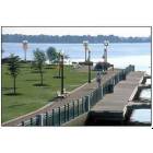
We checked it out over the July 4th weekend - we parked at the canoe launch on Falls of Neuse (note, new road!) and rode our bikes until we couldn't go any further (about 2 miles). There is no pavement under the New Falls of Neuse bridge (see photo below), but you can walk across it. The green way was beautiful! We saw there were several access points into Bedford/Falls River. We cannot wait until the smaller bridges are complete - it is a GEM!
I hit the greenway trail from Bedford today. Took the accees along Bedfordtown Road and road my bike to the new Falls of Neuse Bridge (other side of your shot). It is fantastic. Can't wait for the entire trail to be open soon!
I hit the greenway trail from Bedford today. Took the accees along Bedfordtown Road and road my bike to the new Falls of Neuse Bridge (other side of your shot). It is fantastic. Can't wait for the entire trail to be open soon!
I'd say that the #1 reason my wife and I love Raleigh is the Greenway trails. We usually start at Lassiter Mill Rd and do from end to end (Oak Park off Duraleigh Rd. to Sunnybrook Rd. area off New Bern) We cannot wait for it to trail off to more areas!
Please register to post and access all features of our very popular forum. It is free and quick. Over $68,000 in prizes has already been given out to active posters on our forum. Additional giveaways are planned.
Detailed information about all U.S. cities, counties, and zip codes on our site: City-data.com.

 Please register to participate in our discussions with 2 million other members - it's free and quick! Some forums can only be seen by registered members. After you create your account, you'll be able to customize options and access all our 15,000 new posts/day with fewer ads.