Please register to participate in our discussions with 2 million other members - it's free and quick! Some forums can only be seen by registered members. After you create your account, you'll be able to customize options and access all our 15,000 new posts/day with fewer ads.
Location: The Greatest city on Earth: City of Atlanta Proper
8,485 posts, read 14,994,819 times
Reputation: 7333
Advertisements
Quote:
Originally Posted by johnatl
As well they should. DC, despite how hard it wishes to be, is NOT a NE city.
Miami is a Southern city, whether people from the NE like to admit it or not. It isn't "Southern denial" at all, think of it as a well needed geography lesson. I know Miami gets a "pass" from people who otherwise hate the South because many from your region happen to like the place. It does not change reality.
Ask a native Dade Countian if Miami is Southern or not.
Seriously on the bolded. As I read City-vs-city threads I often wonder how many of the "oh so informed" posters would fail geography and history class for the things they come up with.
As well they should. DC, despite how hard it wishes to be, is NOT a NE city.
It's a Northeastern city and is part of the BosWash corridor as others have correctly pointed out.
Quote:
Originally Posted by johnatl
Miami is a Southern city, whether people from the NE like to admit it or not. It isn't "Southern denial" at all, think of it as a well needed geography lesson. I know Miami gets a "pass" from people who otherwise hate the South because many from your region happen to like the place. It does not change reality.
Ask a native Dade Countian if Miami is Southern or not.
Miami is only southern geographically. It is not southern in any other way. I know many Miami natives who will say exactly that. A look at Miami's history makes it clear that it is a Northeastern city (an extension of NY/NJ, really) geographically located south. Not even "the South", as "the South" only extended as far down as northern/central Florida (hence Univ. of SOUTH Florida being in Tampa, which was considered "South" florida back then).
It's a Northeastern city and is part of the BosWash corridor as others have correctly pointed out.
Miami is only southern geographically. It is not southern in any other way. I know many Miami natives who will say exactly that. A look at Miami's history makes it clear that it is a Northeastern city (an extension of NY/NJ, really) geographically located south. Not even "the South", as "the South" only extended as far down as northern/central Florida (hence Univ. of SOUTH Florida being in Tampa, which was considered "South" florida back then).
DC and Miami are Northeastern.
Denial, denial, denial. As someone who has spent about half his life in Florida, I know what I'm talking about.
If it makes you folks from the NE more comfortable about being in SE Florida by denying it's Southern, keep telling yourselves whatever it takes. They need the $$$$.
DC tries SO HARD to distance itself from its roots, but Southern it is - despite what people further up the "Corridor" wish.
D.C. used to be considered more southern until around the 1960s. However, since that time, the region has become so cosmopolitan that there's practically no trace of southern cultural influence left.
[SIZE=-2]PRINT THIS MAP [/SIZE] [SIZE=-1]The Mason-Dixon Line
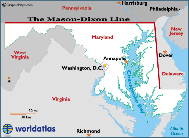
[SIZE=-2]The Mason-Dixon Line became widely known as the symbolic divider between the Northern and Southern states during America's Civil War; in short, it divided slave states from non-slave states. However, the original Mason–Dixon Line was actually a demarcation (or border) line between Pennsylvania and Maryland, in an effort to settle an 80-year land dispute between the two colonies. It also included the western border of present-day Delaware, as it was then a part of the Pennsylvania colony. The on-going dispute between the Penn family of Pennsylvania, and the Calvert family of Maryland over the border between the two colonies finally erupted into war in 1730, one known as Cresap's War. After years of conflict, England's King George II negotiated a cease-fire in 1738. Shortly thereafter, the Penns and Calverts commissioned two Englishman, Charles Mason and Jeremiah Dixon, to mark the official border, and solve their property dispute. Mason (an astronomer) and Dixon (a surveyor) used celestial measurements to form an accurate 233-mile-long line (or boundary) between Pennsylvania and Maryland, and the 83 mile-long between Maryland and Delaware. The project took nearly 5 years, and the new border was marked by large blocks of limestone, some weighing as much as 600 pounds. Today, most of the original stone markers have either deteriorated, or simply disappeared - some say as souvenirs. However, the Mason-Dixon Line still exists. It was last resurveyed in 1902 and found to be remarkably accurate; with minor adjustments, it still serves as the Maryland-Pennsylvania border, while the Mason-Dixon Line of the Civil War days fades into the past.
[/SIZE][/SIZE]
Which some DC residents are afraid to admit. They don't like it when you tell them their city was built in a swamp
LOL, that's ridiculous. I've never heard of Washingtonians being afraid to admit what their city looked like 200 years ago. Who cares? All that matters is what it is today.
I think that for the most part, D.C.today could be classified as Northeastern, as it has far more economic, social, and political ties to Boston, New York, Philadelphia, Wilmington, and Baltimore than to Richmond. But because it is the capital of the United States, and once leaned more Southern in orientation, I would have to call it a Northeastern city with Southern influences. Before the Civil War, I likely would have called it the opposite. I like to think that the Northeast ends and begins to transition into the South once you are below Washington, D.C. By the time you've hit Richmond and central Virginia, you are definitely in the South.
[SIZE=-2]PRINT THIS MAP [/SIZE] [SIZE=-1]The Mason-Dixon Line [/SIZE]
[SIZE=-1][/SIZE]
[SIZE=-1][SIZE=-2]The Mason-Dixon Line became widely known as the symbolic divider between the Northern and Southern states during America's Civil War; in short, it divided slave states from non-slave states. [/SIZE]
[SIZE=-1][/SIZE]
[SIZE=-1] However, the original Mason–Dixon Line was actually a demarcation (or border) line between Pennsylvania and Maryland, in an effort to settle an 80-year land dispute between the two colonies. It also included the western border of present-day Delaware, as it was then a part of the Pennsylvania colony. [/SIZE]
[SIZE=-1][/SIZE]
[SIZE=-1] The on-going dispute between the Penn family of Pennsylvania, and the Calvert family of Maryland over the border between the two colonies finally erupted into war in 1730, one known as Cresap's War. After years of conflict, England's King George II negotiated a cease-fire in 1738. [/SIZE]
[SIZE=-1][/SIZE]
[SIZE=-1] Shortly thereafter, the Penns and Calverts commissioned two Englishman, Charles Mason and Jeremiah Dixon, to mark the official border, and solve their property dispute. [/SIZE]
[SIZE=-1][/SIZE]
[SIZE=-1] Mason (an astronomer) and Dixon (a surveyor) used celestial measurements to form an accurate 233-mile-long line (or boundary) between Pennsylvania and Maryland, and the 83 mile-long between Maryland and Delaware. [/SIZE]
[SIZE=-1][/SIZE]
[SIZE=-1] The project took nearly 5 years, and the new border was marked by large blocks of limestone, some weighing as much as 600 pounds. Today, most of the original stone markers have either deteriorated, or simply disappeared - some say as souvenirs. [/SIZE]
[SIZE=-1][/SIZE]
[SIZE=-1] However, the Mason-Dixon Line still exists. It was last resurveyed in 1902 and found to be remarkably accurate; with minor adjustments, it still serves as the Maryland-Pennsylvania border, while the Mason-Dixon Line of the Civil War days fades into the past. [/SIZE]
[SIZE=-1][/SIZE][/SIZE]
Plus the DE portion also allowed for shipping entry to Philly via the Deleware bay - good post - may go looking for those markers some time
Please register to post and access all features of our very popular forum. It is free and quick. Over $68,000 in prizes has already been given out to active posters on our forum. Additional giveaways are planned.
Detailed information about all U.S. cities, counties, and zip codes on our site: City-data.com.

 Please register to participate in our discussions with 2 million other members - it's free and quick! Some forums can only be seen by registered members. After you create your account, you'll be able to customize options and access all our 15,000 new posts/day with fewer ads.