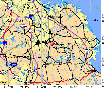
Whitman, Massachusetts
Submit your own pictures of this town and show them to the world
- OSM Map
- General Map
- Google Map
- MSN Map
Population change since 2000: +4.4%
 |
| Males: 7,070 | |
| Females: 7,419 |
| Median resident age: | 38.2 years |
| Massachusetts median age: | 39.2 years |
Zip codes: 02382.
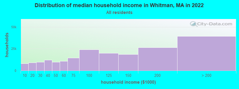
| Whitman: | $102,594 |
| MA: | $94,488 |
Estimated per capita income in 2022: $50,258 (it was $23,002 in 2000)
Whitman town income, earnings, and wages data
Estimated median house or condo value in 2022: $492,984 (it was $158,300 in 2000)
| Whitman: | $492,984 |
| MA: | $534,700 |
Mean prices in 2022: all housing units: $585,203; detached houses: $620,100; townhouses or other attached units: $487,972; in 2-unit structures: $464,355; in 3-to-4-unit structures: $429,583; in 5-or-more-unit structures: $438,441; mobile homes: $207,706; occupied boats, rvs, vans, etc.: $17,153
Detailed information about poverty and poor residents in Whitman, MA


- 13,60393.9%White alone
- 2671.8%Hispanic
- 2051.4%Two or more races
- 1761.2%Black alone
- 1080.7%Asian alone
- 930.6%Other race alone
- 320.2%American Indian alone
- 50.03%Native Hawaiian and Other
Pacific Islander alone
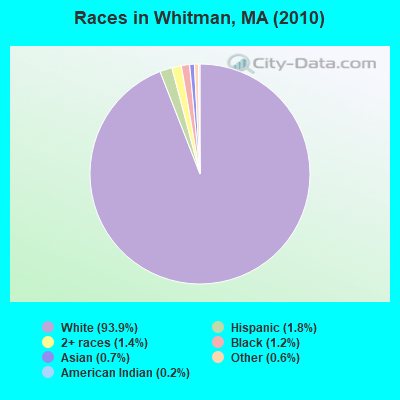
Races in Whitman detailed stats: ancestries, foreign born residents, place of birth
According to our research of Massachusetts and other state lists, there were 6 registered sex offenders living in Whitman, Massachusetts as of May 08, 2024.
The ratio of all residents to sex offenders in Whitman is 2,415 to 1.
The ratio of registered sex offenders to all residents in this city is lower than the state average.
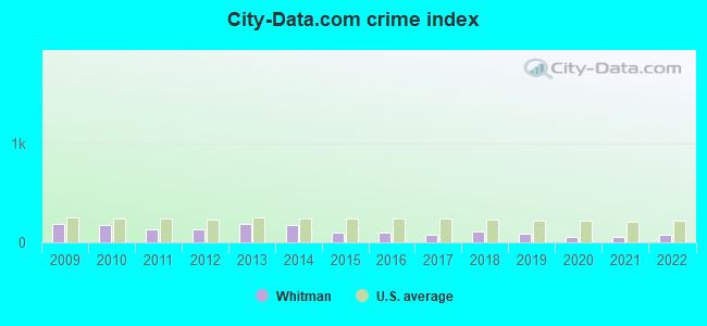
Type |
2009 |
2010 |
2011 |
2012 |
2013 |
2014 |
2015 |
2016 |
2017 |
2018 |
2019 |
2020 |
2021 |
2022 |
|---|---|---|---|---|---|---|---|---|---|---|---|---|---|---|
| Murders (per 100,000) | 0 (0.0) | 0 (0.0) | 0 (0.0) | 0 (0.0) | 0 (0.0) | 0 (0.0) | 0 (0.0) | 0 (0.0) | 0 (0.0) | 0 (0.0) | 0 (0.0) | 0 (0.0) | 0 (0.0) | 0 (0.0) |
| Rapes (per 100,000) | 1 (6.9) | 3 (20.7) | 2 (13.7) | 2 (13.6) | 9 (61.3) | 10 (67.6) | 3 (20.2) | 4 (26.9) | 3 (20.0) | 5 (33.1) | 3 (19.8) | 3 (19.0) | 3 (18.6) | 3 (18.6) |
| Robberies (per 100,000) | 8 (54.9) | 13 (89.7) | 6 (41.2) | 7 (47.6) | 3 (20.4) | 6 (40.6) | 1 (6.7) | 4 (26.9) | 0 (0.0) | 2 (13.3) | 3 (19.8) | 1 (6.3) | 1 (6.2) | 5 (31.0) |
| Assaults (per 100,000) | 43 (295.2) | 35 (241.6) | 32 (219.5) | 34 (231.3) | 42 (286.1) | 37 (250.2) | 30 (201.8) | 25 (168.3) | 22 (146.7) | 31 (205.4) | 27 (178.4) | 14 (88.5) | 15 (93.1) | 22 (136.6) |
| Burglaries (per 100,000) | 59 (405.1) | 67 (462.4) | 50 (343.0) | 31 (210.9) | 43 (292.9) | 47 (317.9) | 20 (134.5) | 26 (175.1) | 15 (100.0) | 15 (99.4) | 21 (138.8) | 13 (82.2) | 9 (55.9) | 15 (93.1) |
| Thefts (per 100,000) | 268 (1,840) | 175 (1,208) | 148 (1,015) | 152 (1,034) | 163 (1,110) | 123 (831.9) | 118 (793.8) | 85 (572.3) | 76 (506.7) | 87 (576.4) | 76 (502.2) | 59 (373.1) | 62 (385.0) | 58 (360.0) |
| Auto thefts (per 100,000) | 12 (82.4) | 10 (69.0) | 10 (68.6) | 8 (54.4) | 10 (68.1) | 7 (47.3) | 8 (53.8) | 10 (67.3) | 5 (33.3) | 9 (59.6) | 7 (46.3) | 6 (37.9) | 9 (55.9) | 19 (117.9) |
| Arson (per 100,000) | 1 (6.9) | 3 (20.7) | 1 (6.9) | 0 (0.0) | 1 (6.8) | 3 (20.3) | 1 (6.7) | 0 (0.0) | 1 (6.7) | 1 (6.6) | 2 (13.2) | 1 (6.3) | 2 (12.4) | 1 (6.2) |
| City-Data.com crime index | 189.6 | 178.0 | 137.3 | 131.9 | 182.7 | 175.6 | 104.0 | 103.8 | 75.3 | 106.3 | 91.0 | 58.5 | 59.2 | 81.9 |
The City-Data.com crime index weighs serious crimes and violent crimes more heavily. Higher means more crime, U.S. average is 246.1. It adjusts for the number of visitors and daily workers commuting into cities.
Crime rate in Whitman detailed stats: murders, rapes, robberies, assaults, burglaries, thefts, arson
Full-time law enforcement employees in 2019, including police officers: 27 (26 officers - 25 male; 1 female).
| Officers per 1,000 residents here: | 1.72 |
| Massachusetts average: | 2.59 |
 Recent articles from our blog. Our writers, many of them Ph.D. graduates or candidates, create easy-to-read articles on a wide variety of topics.


 | 2023 Real Estate Observations (5278 replies) |
| Police expecting a rough summer ahead, in the city. (2484 replies) |
| November 2022...closed restaurants, bars and shops (201 replies) |
| Home Prices By Town for 2022 (190 replies) |
| 2021 Real Estate Observations (1729 replies) |
| Three Cheers for Whitman Marijuana LOST! The People said NO TO MARIJUANA in Special Town Election (100 replies) |
Latest news from Whitman, MA collected exclusively by city-data.com from local newspapers, TV, and radio stations
Ancestries: Irish (39.5%), Italian (16.5%), English (15.6%), French (6.2%), German (6.0%), French Canadian (5.9%).
Current Local Time: EST time zone
Incorporated in 1875
Elevation: 110 feet
Land area: 6.96 square miles.
Population density: 2,083 people per square mile (low).
308 residents are foreign born (1.2% Europe, 0.6% North America, 0.3% Asia).
| This town: | 2.2% |
| Massachusetts: | 12.2% |
| Whitman town: | 1.6% ($2,506) |
| Massachusetts: | 1.3% ($2,336) |
Nearest city with pop. 50,000+: Brockton, MA  (4.3 miles , pop. 94,304).
Nearest city with pop. 200,000+: Boston, MA (18.3 miles , pop. 589,141).
Nearest city with pop. 1,000,000+: Bronx, NY (174.5 miles , pop. 1,332,650).
Nearest cities:
), ), ), )Latitude: 42.08 N, Longitude: 70.94 W
Area code: 781

Whitman, Massachusetts accommodation & food services, waste management - Economy and Business Data
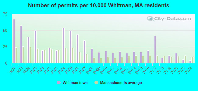
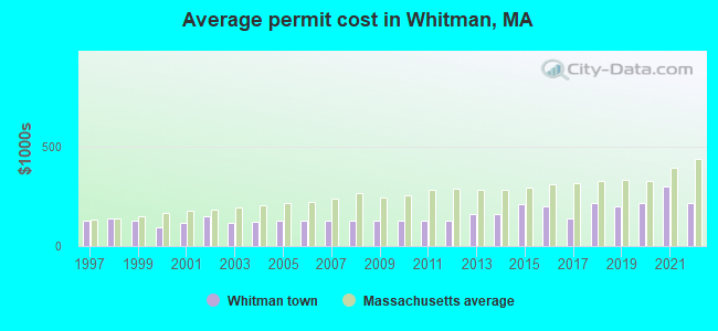
Single-family new house construction building permits:
- 2022: 6 buildings, average cost: $216,700
- 2021: 8 buildings, average cost: $297,400
- 2020: 21 buildings, average cost: $214,200
- 2019: 16 buildings, average cost: $196,700
- 2018: 11 buildings, average cost: $217,500
- 2017: 58 buildings, average cost: $138,800
- 2016: 27 buildings, average cost: $200,800
- 2015: 24 buildings, average cost: $211,900
- 2014: 25 buildings, average cost: $161,900
- 2013: 21 buildings, average cost: $157,500
- 2012: 25 buildings, average cost: $127,700
- 2011: 22 buildings, average cost: $127,700
- 2010: 26 buildings, average cost: $127,700
- 2009: 23 buildings, average cost: $127,700
- 2008: 31 buildings, average cost: $127,700
- 2007: 48 buildings, average cost: $127,700
- 2006: 61 buildings, average cost: $127,400
- 2005: 69 buildings, average cost: $129,000
- 2004: 75 buildings, average cost: $123,300
- 2003: 27 buildings, average cost: $117,000
- 2002: 33 buildings, average cost: $147,200
- 2001: 27 buildings, average cost: $114,800
- 2000: 68 buildings, average cost: $92,000
- 1999: 55 buildings, average cost: $126,800
- 1998: 80 buildings, average cost: $137,000
- 1997: 93 buildings, average cost: $125,000
| Here: | 3.6% |
| Massachusetts: | 3.5% |


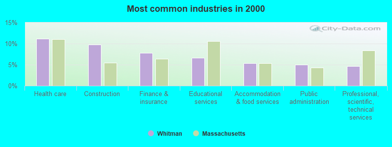
- Health care (11.2%)
- Construction (9.8%)
- Finance & insurance (7.8%)
- Educational services (6.6%)
- Accommodation & food services (5.4%)
- Public administration (5.0%)
- Professional, scientific, technical services (4.6%)
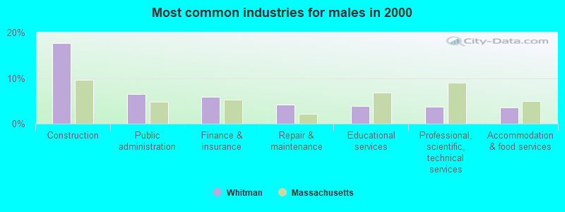
- Construction (17.7%)
- Public administration (6.5%)
- Finance & insurance (5.9%)
- Repair & maintenance (4.1%)
- Educational services (3.9%)
- Professional, scientific, technical services (3.8%)
- Accommodation & food services (3.5%)
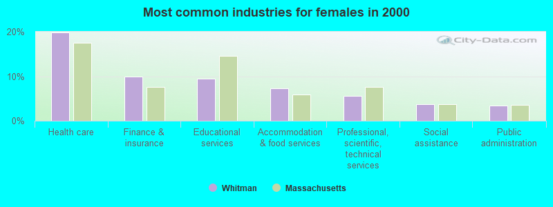
- Health care (19.9%)
- Finance & insurance (9.9%)
- Educational services (9.5%)
- Accommodation & food services (7.3%)
- Professional, scientific, technical services (5.6%)
- Social assistance (3.8%)
- Public administration (3.4%)

- Other sales and related occupations, including supervisors (4.4%)
- Other office and administrative support workers, including supervisors (4.2%)
- Retail sales workers, except cashiers (4.0%)
- Other management occupations, except farmers and farm managers (3.3%)
- Material recording, scheduling, dispatching, and distributing workers (3.2%)
- Building and grounds cleaning and maintenance occupations (2.9%)
- Health technologists and technicians (2.9%)
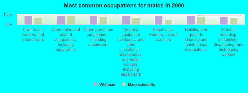
- Driver/sales workers and truck drivers (4.3%)
- Other sales and related occupations, including supervisors (4.2%)
- Other production occupations, including supervisors (4.1%)
- Electrical equipment mechanics and other installation, maintenance, and repair workers, including supervisors (4.1%)
- Retail sales workers, except cashiers (4.1%)
- Building and grounds cleaning and maintenance occupations (4.1%)
- Material recording, scheduling, dispatching, and distributing workers (3.7%)
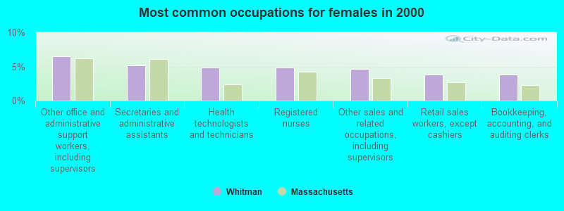
- Other office and administrative support workers, including supervisors (6.5%)
- Secretaries and administrative assistants (5.2%)
- Health technologists and technicians (4.8%)
- Registered nurses (4.8%)
- Other sales and related occupations, including supervisors (4.6%)
- Retail sales workers, except cashiers (3.8%)
- Bookkeeping, accounting, and auditing clerks (3.8%)
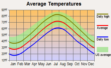
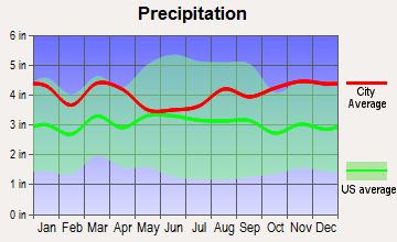
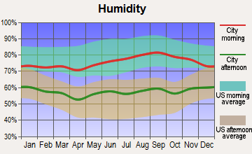
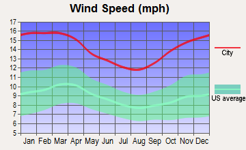
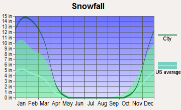
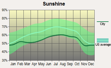
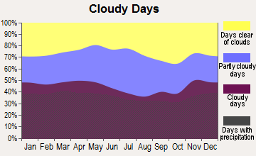
Average climate in Whitman, Massachusetts
Based on data reported by over 4,000 weather stations
(lower is better)
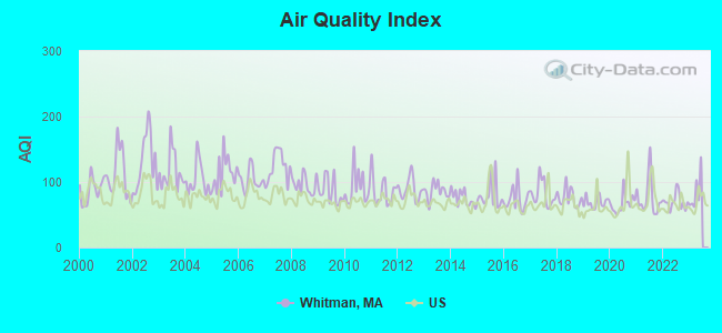
Air Quality Index (AQI) level in 2022 was 70.0. This is about average.
| City: | 70.0 |
| U.S.: | 72.6 |
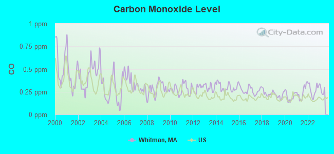
Carbon Monoxide (CO) [ppm] level in 2022 was 0.269. This is about average. Closest monitor was 11.4 miles away from the city center.
| City: | 0.269 |
| U.S.: | 0.251 |

Nitrogen Dioxide (NO2) [ppb] level in 2022 was 6.17. This is worse than average. Closest monitor was 10.9 miles away from the city center.
| City: | 6.17 |
| U.S.: | 5.11 |
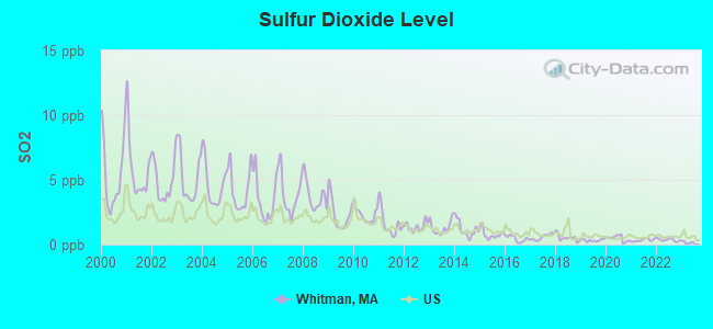
Sulfur Dioxide (SO2) [ppb] level in 2022 was 0.358. This is significantly better than average. Closest monitor was 4.0 miles away from the city center.
| City: | 0.358 |
| U.S.: | 1.515 |
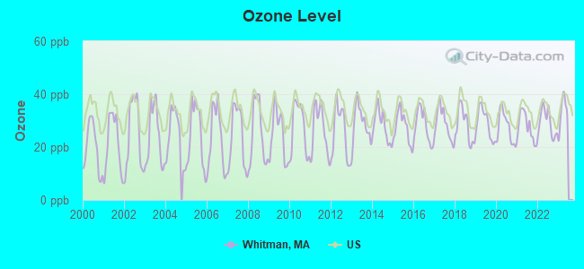
Ozone [ppb] level in 2022 was 29.2. This is about average. Closest monitor was 4.0 miles away from the city center.
| City: | 29.2 |
| U.S.: | 33.3 |
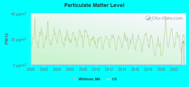
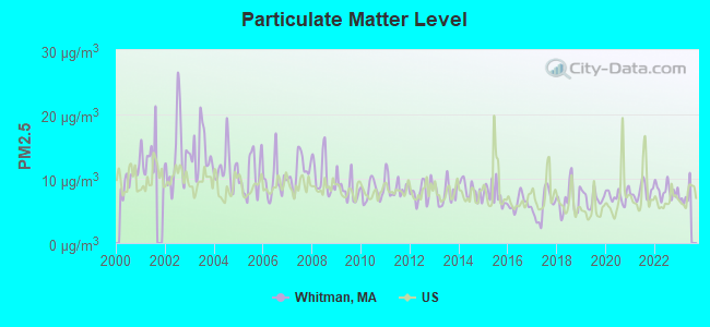
Particulate Matter (PM2.5) [µg/m3] level in 2022 was 8.16. This is about average. Closest monitor was 4.0 miles away from the city center.
| City: | 8.16 |
| U.S.: | 8.11 |
Tornado activity:
Whitman-area historical tornado activity is slightly below Massachusetts state average. It is 56% smaller than the overall U.S. average.
On 6/9/1953, a category F4 (max. wind speeds 207-260 mph) tornado 33.4 miles away from the Whitman town center killed 90 people and injured 1228 people and caused between $50,000,000 and $500,000,000 in damages.
On 6/9/1953, a category F3 (max. wind speeds 158-206 mph) tornado 13.7 miles away from the town center injured 17 people and caused between $500,000 and $5,000,000 in damages.
Earthquake activity:
Whitman-area historical earthquake activity is significantly above Massachusetts state average. It is 74% smaller than the overall U.S. average.On 10/7/1983 at 10:18:46, a magnitude 5.3 (5.1 MB, 5.3 LG, 5.1 ML, Class: Moderate, Intensity: VI - VII) earthquake occurred 215.3 miles away from the city center
On 4/20/2002 at 10:50:47, a magnitude 5.3 (5.3 ML, Depth: 3.0 mi) earthquake occurred 218.0 miles away from the city center
On 1/19/1982 at 00:14:42, a magnitude 4.7 (4.5 MB, 4.7 MD, 4.5 LG, Class: Light, Intensity: IV - V) earthquake occurred 103.7 miles away from Whitman center
On 10/16/2012 at 23:12:25, a magnitude 4.7 (4.7 ML, Depth: 10.0 mi) earthquake occurred 105.8 miles away from the city center
On 4/20/2002 at 10:50:47, a magnitude 5.2 (5.2 MB, 4.2 MS, 5.2 MW, 5.0 MW) earthquake occurred 217.4 miles away from Whitman center
On 8/22/1992 at 12:20:32, a magnitude 4.8 (4.8 MB, 3.8 MS, 4.7 LG, Depth: 6.2 mi) earthquake occurred 208.4 miles away from the city center
Magnitude types: regional Lg-wave magnitude (LG), body-wave magnitude (MB), duration magnitude (MD), local magnitude (ML), surface-wave magnitude (MS), moment magnitude (MW)
Natural disasters:
The number of natural disasters in Plymouth County (26) is a lot greater than the US average (15).Major Disasters (Presidential) Declared: 17
Emergencies Declared: 9
Causes of natural disasters: Floods: 11, Storms: 9, Hurricanes: 7, Snows: 3, Snowstorms: 3, Blizzards: 2, Winter Storms: 2, Heavy Rain: 1, Snowfall: 1, Tropical Storm: 1, Wind: 1 (Note: some incidents may be assigned to more than one category).
Hospitals and medical centers in Whitman:
Other hospitals and medical centers near Whitman:
- COLONY HOUSE HEALTH CARE (Nursing Home, about 2 miles away; ABINGTON, MA)
- KINDRED NURSING AND REHABILITATION-COLONY HOUSE (Nursing Home, about 2 miles away; ABINGTON, MA)
- CHAMPION REHABILITATION AND HEALTH CENTER (Nursing Home, about 3 miles away; BROCKTON, MA)
- EMBASSY HOUSE HEALTHCARE NURS HOME (Nursing Home, about 3 miles away; BROCKTON, MA)
- REGENT PARK LONG TERM CARE CENTER (Nursing Home, about 3 miles away; BROCKTON, MA)
- REGENT PARK MANOR REHAB AND SKILLED CARE CENTER (Nursing Home, about 3 miles away; BROCKTON, MA)
- REGENT PARK NURS RETIREMENT HME (Nursing Home, about 3 miles away; BROCKTON, MA)
Amtrak stations near Whitman:
- 14 miles: ROUTE 128 (WESTWOOD, UNIVERSITY AVE. & RTE. 128) . Services: ticket office, enclosed waiting area, public restrooms, public payphones, vending machines, paid short-term parking, taxi stand, public transit connection.
- 20 miles: BOSTON (SO. STA) (BOSTON, ATLANTIC AVE. & SUMMER ST.) . Services: ticket office, fully wheelchair accessible, enclosed waiting area, public restrooms, public payphones, full-service food facilities and snack bar, ATM, paid short-term parking, paid long-term parking, call for car rental service, taxi stand, intercity bus service, public transit connection.
- 20 miles: BACK BAY (BOSTON, 145 DARTMOUTH ST.) . Services: ticket office, partially wheelchair accessible, enclosed waiting area, public restrooms, public payphones, vending machines, ATM, paid short-term parking, paid long-term parking, call for car rental service, taxi stand, public transit connection.
Operable nuclear power plant near Whitman:
- 17 miles: Pilgrim in Plymouth, MA.
Colleges/universities with over 2000 students nearest to Whitman:
- Massasoit Community College (about 3 miles; Brockton, MA; Full-time enrollment: 5,442)
- Bridgewater State University (about 7 miles; Bridgewater, MA; FT enrollment: 9,802)
- Stonehill College (about 8 miles; Easton, MA; FT enrollment: 2,563)
- Quincy College (about 13 miles; Quincy, MA; FT enrollment: 3,184)
- Curry College (about 15 miles; Milton, MA; FT enrollment: 2,586)
- University of Massachusetts-Boston (about 17 miles; Boston, MA; FT enrollment: 12,625)
- Wentworth Institute of Technology (about 20 miles; Boston, MA; FT enrollment: 4,418)
Public high school in Whitman:
- WHITMAN HANSON REGIONAL (Students: 1,244, Location: 600 FRANKLIN STREET, Grades: 9-12)
Public elementary/middle schools in Whitman:
- JOHN H DUVAL (Students: 559, Location: 60 REGAL STREET, Grades: KG-5)
- WHITMAN MIDDLE (Students: 556, Location: 101 CORTHELL AVENUE, Grades: 6-8)
- LOUISE A CONLEY (Students: 534, Location: 100 FOREST STREET, Grades: KG-5)
Private elementary/middle school in Whitman:
Points of interest:
Notable locations in Whitman: Whitman Station (A), Whitman Fire and Rescue (B), Whitman Townhall (C), Duval Elementary School Library (D), Whitman Public Library (E), Whitman Town Hall (F). Display/hide their locations on the map
Churches in Whitman include: South Shore Pentecostal Church (A), All Saints Episcopal Church (B). Display/hide their locations on the map
Cemeteries: Mount Zion Cemetery (1), Colebrook Cemetery (2), Saint James Cemetery (3). Display/hide their locations on the map
Lakes, reservoirs, and swamps: Hobart Pond (A), Hardings Pond (B), Bear Meadow (C). Display/hide their locations on the map
River: Stream River (A). Display/hide its location on the map
Birthplace of: Francis Spellman - Catholic cardinal, Steve Smith (musician) - Jazz drummer.
Drinking water stations with addresses in Whitman and their reported violations in the past:
WHITMAN WATER SYSTEM (Population served: 14,574, Purch surface water):Past health violations:Past monitoring violations:
- MCL, Monthly (TCR) - In APR-2008, Contaminant: Coliform. Follow-up actions: St AO (w/o penalty) issued (JUN-05-2008), St Compliance achieved (JUN-30-2008)
- MCL, Monthly (TCR) - In FEB-2006, Contaminant: Coliform. Follow-up actions: St AO (w/o penalty) issued (NOV-29-2006), St Compliance achieved (NOV-29-2006)
- Notification, State - In FEB-2010, Contaminant: Coliform (TCR). Follow-up actions: St AO (w/o penalty) issued (JUN-04-2010), St Compliance achieved (JUN-04-2010)
- Follow-up Or Routine LCR Tap M/R - In OCT-01-2006, Contaminant: Lead and Copper Rule. Follow-up actions: St AO (w/o penalty) issued (NOV-20-2006), St Compliance achieved (DEC-19-2006)
- Initial Tap Sampling for Pb and Cu - In JUL-01-1992, Contaminant: Lead and Copper Rule
| This town: | 2.7 people |
| Massachusetts: | 2.5 people |
| This town: | 70.7% |
| Whole state: | 63.0% |
| This town: | 7.8% |
| Whole state: | 7.0% |
Likely homosexual households (counted as self-reported same-sex unmarried-partner households)
- Lesbian couples: 0.5% of all households
- Gay men: 0.3% of all households
| This town: | 3.3% |
| Whole state: | 9.3% |
| This town: | 1.9% |
| Whole state: | 4.4% |
18 people in group homes intended for adults in 2010
People in group quarters in Whitman in 2000:
- 20 people in mental (psychiatric) hospitals or wards
- 20 people in other noninstitutional group quarters
- 4 people in homes for the mentally retarded
Banks with branches in Whitman (2011 data):
- Sovereign Bank, National Association: Landmark/Whitman Branch at 584 Washington Street, branch established on 1888/02/18. Info updated 2012/01/31: Bank assets: $78,146.9 mil, Deposits: $48,042.9 mil, headquarters in Wilmington, DE, positive income, Commercial Lending Specialization, 718 total offices, Holding Company: Banco Santander, S.A.
- Rockland Trust Company: Whitman Branch at 692 Bedford St, branch established on 1976/12/20. Info updated 2009/05/20: Bank assets: $4,974.4 mil, Deposits: $3,903.9 mil, headquarters in Rockland, MA, positive income, Commercial Lending Specialization, 67 total offices, Holding Company: Independent Bank Corp.
- RBS Citizens, National Association: Whitman Stop And Shop Branch at 475 Bedford Street Rt 18, branch established on 2002/12/12. Info updated 2007/09/19: Bank assets: $106,940.6 mil, Deposits: $75,690.2 mil, headquarters in Providence, RI, positive income, 1135 total offices, Holding Company: Uk Financial Investments Limited
- Mutual Federal Savings Bank of Plymouth County: Mutual Federal Savings Bank Of Plymo at 570 Washington St, branch established on 1889/01/01. Info updated 2011/07/21: Bank assets: $369.9 mil, Deposits: $260.8 mil, local headquarters, positive income, Mortgage Lending Specialization, 9 total offices
For population 15 years and over in Whitman:
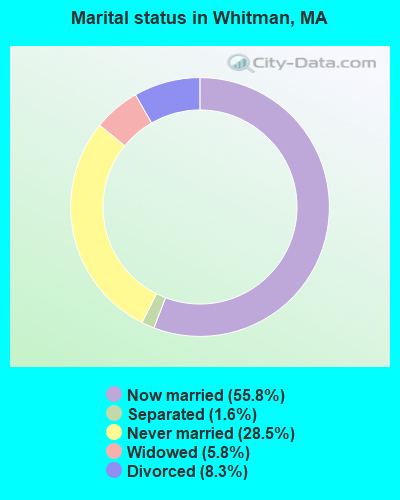
- Never married: 28.5%
- Now married: 55.8%
- Separated: 1.6%
- Widowed: 5.8%
- Divorced: 8.3%
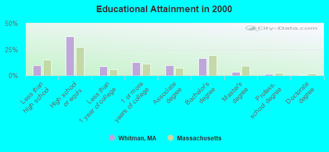
For population 25 years and over in Whitman:
- High school or higher: 90.2%
- Bachelor's degree or higher: 21.7%
- Graduate or professional degree: 5.3%
- Unemployed: 3.4%
- Mean travel time to work (commute): 30.2 minutes
| Here: | 8.7 |
| Massachusetts average: | 13.1 |


Graphs represent county-level data. Detailed 2008 Election Results
Religion statistics for Whitman, MA (based on Plymouth County data)


| Religion | Adherents | Congregations |
|---|---|---|
| Catholic | 165,985 | 35 |
| Mainline Protestant | 23,724 | 91 |
| Evangelical Protestant | 13,159 | 96 |
| Other | 6,129 | 43 |
| Orthodox | 1,140 | 3 |
| Black Protestant | 611 | 5 |
| None | 284,171 | - |
Food Environment Statistics:
| Plymouth County: | 1.74 / 10,000 pop. |
| Massachusetts: | 1.98 / 10,000 pop. |
| This county: | 0.04 / 10,000 pop. |
| Massachusetts: | 0.05 / 10,000 pop. |
| This county: | 2.84 / 10,000 pop. |
| Massachusetts: | 2.22 / 10,000 pop. |
| Plymouth County: | 2.20 / 10,000 pop. |
| Massachusetts: | 1.77 / 10,000 pop. |
| Plymouth County: | 7.37 / 10,000 pop. |
| Massachusetts: | 8.76 / 10,000 pop. |
| Plymouth County: | 7.9% |
| Massachusetts: | 8.1% |
| This county: | 21.7% |
| State: | 22.5% |
| This county: | 16.3% |
| Massachusetts: | 16.5% |
5.54% of this county's 2020 resident taxpayers moved to other counties in 2021 ($85,482 average adjusted gross income)
| Here: | 5.54% |
| Massachusetts average: | 7.18% |
0.01% of residents moved to foreign countries ($80 average AGI)
Plymouth County: 0.01% Massachusetts average: 0.02%
Top counties to which taxpayers relocated from this county between 2020 and 2021:
| to Bristol County, MA | |
| to Norfolk County, MA | |
| to Suffolk County, MA |
| Businesses in Whitman, MA | ||||
| Name | Count | Name | Count | |
|---|---|---|---|---|
| 7-Eleven | 1 | McDonald's | 1 | |
| Burger King | 1 | Stop & Shop | 1 | |
| CVS | 1 | The Room Place | 1 | |
| Chevrolet | 1 | U-Haul | 1 | |
| Curves | 1 | UPS | 2 | |
| Dunkin Donuts | 3 | Walgreens | 1 | |
| FedEx | 1 | Wendy's | 1 | |
| MasterBrand Cabinets | 2 | |||
Strongest AM radio stations in Whitman:
- WBZ (1030 AM; 50 kW; BOSTON, MA; Owner: INFINITY BROADCASTING OPERATIONS, INC.)
- WEEI (850 AM; 50 kW; BOSTON, MA; Owner: ENTERCOM BOSTON LICENSE, LLC)
- WBET (1460 AM; 5 kW; BROCKTON, MA; Owner: KJI BROADCASTING, LLC)
- WRKO (680 AM; 50 kW; BOSTON, MA; Owner: ENTERCOM BOSTON LICENSE, LLC)
- WWZN (1510 AM; 50 kW; BOSTON, MA; Owner: ROSE CITY RADIO CORPORATION)
- WKOX (1200 AM; 50 kW; FRAMINGHAM, MA; Owner: CAPSTAR TX LIMITED PARTNERSHIP)
- WBIX (1060 AM; 40 kW; NATICK, MA; Owner: LANGER BROADCASTING CORPORATION)
- WALE (990 AM; 50 kW; GREENVILLE, RI; Owner: NORTH AMERICAN BROADCASTING CO., INC.)
- WAMG (890 AM; 25 kW; DEDHAM, MA; Owner: MEGA COMMUNICATIONS OF DEDHAM LICENSEE, LLC)
- WUNR (1600 AM; 20 kW; BROOKLINE, MA; Owner: CHAMPION BROADCASTING SYSTEMS, INC.)
- WRCA (1330 AM; 25 kW; WALTHAM, MA; Owner: WRCA LICENSE, LLC)
- WMSX (1410 AM; 1 kW; BROCKTON, MA; Owner: ANASTOS MEDIA GROUP, INC.)
- WCRN (830 AM; 50 kW; WORCESTER, MA; Owner: CARTER BROADCASTING CORPORATION)
Strongest FM radio stations in Whitman:
- WBOT (97.7 FM; BROCKTON, MA; Owner: RADIO ONE LICENSES, LLC)
- WRPS (88.3 FM; ROCKLAND, MA; Owner: ROCKLAND PUBLIC SCHOOLS)
- WXKS-FM (107.9 FM; MEDFORD, MA; Owner: AMFM RADIO LICENSES, L.L.C.)
- WMJX (106.7 FM; BOSTON, MA; Owner: GREATER BOSTON RADIO, INC.)
- WBMX (98.5 FM; BOSTON, MA; Owner: INFINITY RADIO OPERATIONS INC.)
- WBOS (92.9 FM; BROOKLINE, MA; Owner: GREATER BOSTON RADIO, INC.)
- WJMN (94.5 FM; BOSTON, MA; Owner: AMFM RADIO LICENSES, L.L.C.)
- WCRB (102.5 FM; WALTHAM, MA; Owner: CHARLES RIVER BROADCASTING WCRB LICE)
- WTKK (96.9 FM; BOSTON, MA; Owner: GREATER BOSTON RADIO, INC.)
- WROR-FM (105.7 FM; FRAMINGHAM, MA; Owner: GREATER BOSTON RADIO, INC.)
- WGBH (89.7 FM; BOSTON, MA; Owner: WGBH EDUCATIONAL FOUNDATION)
- WBUR-FM (90.9 FM; BOSTON, MA; Owner: TRUSTEES OF BOSTON UNIVERSITY)
- WATD-FM (95.9 FM; MARSHFIELD, MA; Owner: MARSHFIELD BROADCASTING CO., INC.)
- WODS (103.3 FM; BOSTON, MA; Owner: INFINITY BROADCASTING OPERATIONS, INC.)
- WBCN (104.1 FM; BOSTON, MA; Owner: HEMISPHERE BROADCASTING CORPORATION)
- WZLX (100.7 FM; BOSTON, MA; Owner: INFINITY BROADCASTING CORPORATION OF BOSTON)
- W267AI (101.3 FM; BOSTON, MA; Owner: MCC BROADCASTING COMPANY, INC.)
- WWBB (101.5 FM; PROVIDENCE, RI; Owner: CLEAR CHANNEL BROADCASTING LICENSES, INC.)
- WERS (88.9 FM; BOSTON, MA; Owner: EMERSON COLLEGE)
- WPLM-FM (99.1 FM; PLYMOUTH, MA; Owner: PLYMOUTH ROCK BROADCASTING CO., INC.)
TV broadcast stations around Whitman:
- WWDP (Channel 46; NORWELL, MA; Owner: NORWELL TELEVISION, LLC)
- WCVB-TV (Channel 5; BOSTON, MA; Owner: WCVB HEARST-ARGYLE TV, INC.)
- WGBH-TV (Channel 2; BOSTON, MA; Owner: WGBH EDUCATIONAL FOUNDATION)
- WHDH-TV (Channel 7; BOSTON, MA; Owner: WHDH-TV)
- WMFP (Channel 62; LAWRENCE, MA; Owner: WSAH LICENSE, INC.)
- WSBK-TV (Channel 38; BOSTON, MA; Owner: VIACOM INC.)
- WLVI-TV (Channel 56; CAMBRIDGE, MA; Owner: WLVI, INC.)
- WBZ-TV (Channel 4; BOSTON, MA; Owner: VIACOM INC.)
- WGBX-TV (Channel 44; BOSTON, MA; Owner: WGBH EDUCATIONAL FOUNDATION)
- WFXT (Channel 25; BOSTON, MA; Owner: FOX TELEVISION STATIONS INC.)
- WBPX (Channel 68; BOSTON, MA; Owner: PAXSON BOSTON-68 LICENSE, INC.)
- WLNE-TV (Channel 6; NEW BEDFORD, MA; Owner: FREEDOM BROADCASTING OF SOUTHERN NEW ENGLAND, INC.)
- WTMU-LP (Channel 32; BOSTON, MA; Owner: ZGS BOSTON, INC.)
- WCEA-LP (Channel 58; BOSTON, MA; Owner: CHANNEL 19 TV CORPORATION)
- W40BO (Channel 40; BOSTON, MA; Owner: PAXSON COMMUNICATIONS LPTV, INC.)
- WPRI-TV (Channel 12; PROVIDENCE, RI; Owner: TVL BROADCASTING OF RHODE ISLAND, LLC)
- WNAC-TV (Channel 64; PROVIDENCE, RI; Owner: WNAC, LLC)
- WJAR (Channel 10; PROVIDENCE, RI; Owner: OUTLET BROADCASTING, INC.)
- WLWC (Channel 28; NEW BEDFORD, MA; Owner: C-28 FCC LICENSEE SUBSIDIARY, LLC)
- WSBE-TV (Channel 36; PROVIDENCE, RI; Owner: RHODE ISLAND PUBLIC TELECOM. AUTHORITY)
- WUTF (Channel 66; MARLBOROUGH, MA; Owner: TELEFUTURA BOSTON LLC)
- WUNI (Channel 27; WORCESTER, MA; Owner: ENTRAVISION HOLDINGS, LLC)
- WPXQ (Channel 69; BLOCK ISLAND, RI; Owner: OCEAN STATE TELEVISION, L.L.C.)
FCC Registered Broadcast Land Mobile Towers:
7- 43 Ford Park Circle (Lat: 42.092611 Lon: -70.942556), Call Sign: KVJ849,
Assigned Frequencies: 155.895 MHz, Grant Date: 09/28/2005, Expiration Date: 11/08/2015, Cancellation Date: 01/09/2016, Registrant: Town Of Whitman, Whitman, MA 02382, Phone: (781) 618-9704, Fax: (781) 447-7307, Email:
- Whitman Fire Hdqtrs (Lat: 42.080389 Lon: -70.938944), Type: Tower, Structure height: 15 m, Overall height: 30 m, Call Sign: WQD652,
Assigned Frequencies: 151.205 MHz, 151.235 MHz, 151.310 MHz, 151.370 MHz, 151.415 MHz, Grant Date: 03/20/2002, Expiration Date: 05/27/2012, Cancellation Date: 07/28/2012, Certifier: Richard Geyster, Registrant: Dept Of Envir Mgmt Div Of Forest & Parks, Princeton, MA 01541
- 20 Essex St (Lat: 42.080944 Lon: -70.935889), Type: Bant, Structure height: 18 m, Call Sign: WBP532,
Assigned Frequencies: 485.887 MHz, 486.012 MHz, 486.037 MHz, Grant Date: 12/21/2011, Expiration Date: 02/06/2022, Cancellation Date: 04/09/2022, Registrant: Central Ma Public Safety Assn Inc, Warren, MA 01083-0637, Phone: (877) 267-7291, Email:
- HIGH SCHOOL, 600 Franklin Street (Lat: 42.073333 Lon: -70.903889), Type: Bant, Structure height: 16 m, Call Sign: WPLQ701,
Assigned Frequencies: 472.400 MHz, Grant Date: 11/04/2022, Expiration Date: 12/01/2032, Certifier: Timothy Travers, Registrant: Town Of Whitman, 54 South Ave, Whitman, MA 02382, Phone: (781) 618-9780, Email:
- 5 Walnut St (Lat: 42.083444 Lon: -70.938389), Call Sign: KEM987, Licensee ID: L00032560,
Assigned Frequencies: 35.9400 MHz, Grant Date: 02/08/2003, Expiration Date: 02/18/2013, Cancellation Date: 04/20/2013, Registrant: Welch, William E Dba William E Welch Electrical Contractor In, 5 Walnut St, Whitman, MA 02382
- 56 Temple Street (Lat: 42.080000 Lon: -70.939167), Type: Bant, Structure height: 26 m, Call Sign: WQBD545,
Assigned Frequencies: 484.250 MHz, Grant Date: 07/22/2014, Expiration Date: 09/23/2024, Certifier: Jack Schnyer, Registrant: Federal License Management, 1784 E. 3rd Street Suite 269, Williamsport, PA 17701-3862, Phone: (866) 908-2220, Fax: (570) 322-6825, Email:
- Lat: 42.080333 Lon: -70.937250, Call Sign: WRDC417,
Assigned Frequencies: 451.793 MHz, 456.793 MHz, Grant Date: 03/26/2019, Expiration Date: 03/26/2029, Certifier: Charlie Montelongo, Registrant: Master Meter Inc., 101 Regency Parkway, Mansfield, TX 76063-5093, Phone: (817) 842-8000, Fax: (817) 842-8030, Email:
FCC Registered Microwave Towers:
3- WHITMAN, 1 Old Coach Rd (Lat: 42.066389 Lon: -70.918444), Type: Mast, Structure height: 58.2 m, Overall height: 58.8 m, Call Sign: WPNG941,
Assigned Frequencies: 10561.2 MHz, 10657.5 MHz, 10668.1 MHz, Grant Date: 03/07/2011, Expiration Date: 02/01/2021, Cancellation Date: 04/05/2012, Certifier: Carol L Tacker, Registrant: At&t Mobility LLC, 5601 Legacy Drive, Ms: A-3, Plano, TX 75024, Phone: (469) 229-7471, Fax: (469) 229-7297, Email:
- BOS0834, 185 Franklin St. (Lat: 42.078861 Lon: -70.918056), Type: Tower, Structure height: 37.5 m, Call Sign: WQDT496, Licensee ID: L01728370,
Assigned Frequencies: 17920.0 MHz, Grant Date: 10/26/2005, Expiration Date: 10/26/2015, Cancellation Date: 09/09/2013, Certifier: Joseph M Sandri Jr., Registrant: Fibertower Network Services, Corp., Debtor-In-Possession, 1875 Eye Street, Nw, 5th Floor, Room 505, Washington, DC 20006, Phone: (202) 223-1028, Email:
- WHITMAN FD, 56 Temple St (Lat: 42.080083 Lon: -70.939500), Type: Bant, Structure height: 22.9 m, Call Sign: WRDH582,
Assigned Frequencies: 11075.0 MHz, 11075.0 MHz, 11075.0 MHz, 11075.0 MHz, 11075.0 MHz, 11075.0 MHz, 11075.0 MHz, 11075.0 MHz, 11075.0 MHz, 11075.0 MHz, Grant Date: 04/30/2019, Expiration Date: 04/30/2029, Certifier: Timothy Grenno, Registrant: All Comm, 5 Whitmore Rd., Revere, MA 02151, Phone: (781) 289-3000, Fax: (781) 289-7300, Email:
FCC Registered Amateur Radio Licenses:
81 (See the full list of FCC Registered Amateur Radio Licenses in Whitman)FAA Registered Aircraft Manufacturers and Dealers:
1- RIDDER AIR ENTERPRISES INC, P O Box 310, Whitman, MA 02382
Certificate: D002146 (Corporation), Certificate Issue Date: 05/20/2012, Expiration Date: 05/19/2013
FAA Registered Aircraft:
2- Aircraft: CESSNA 150G (Category: Land, Seats: 2, Weight: Up to 12,499 Pounds, Speed: 90 mph), Engine: CONT MOTOR 0-200 SERIES (100 HP) (4 Cycle)
N-Number: 2474J, N2474J, N-2474J, Serial Number: 15065574, Year manufactured: 1966, Airworthiness Date: 11/17/1966, Certificate Issue Date: 12/19/2018
Registrant (Individual): Mark Hamill, 146 South Ave, Whitman, MA 02382 - Aircraft: PIPER PA-28-181 (Category: Land, Seats: 4, Weight: Up to 12,499 Pounds, Speed: 105 mph), Engine: LYCOMING O&VO-360 SER (180 HP) (Reciprocating)
N-Number: 2771Q, N2771Q, N-2771Q, Serial Number: 28-7790418, Year manufactured: 1977, Airworthiness Date: 03/17/1977, Certificate Issue Date: 06/21/2016
Registrant (Individual): Eric P Brunelle, 63 Robert Ave, Whitman, MA 02382
2002 - 2018 National Fire Incident Reporting System (NFIRS) incidents
- Fire incident types reported to NFIRS in Whitman, MA
- 35847.7%Structure Fires
- 31241.6%Outside Fires
- 739.7%Mobile Property/Vehicle Fires
- 70.9%Other
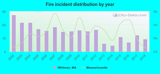 Based on the data from the years 2002 - 2018 the average number of fire incidents per year is 44. The highest number of reported fire incidents - 82 took place in 2002, and the least - 14 in 2014. The data has a dropping trend.
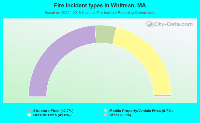 When looking into fire subcategories, the most reports belonged to: Structure Fires (47.7%), and Outside Fires (41.6%).
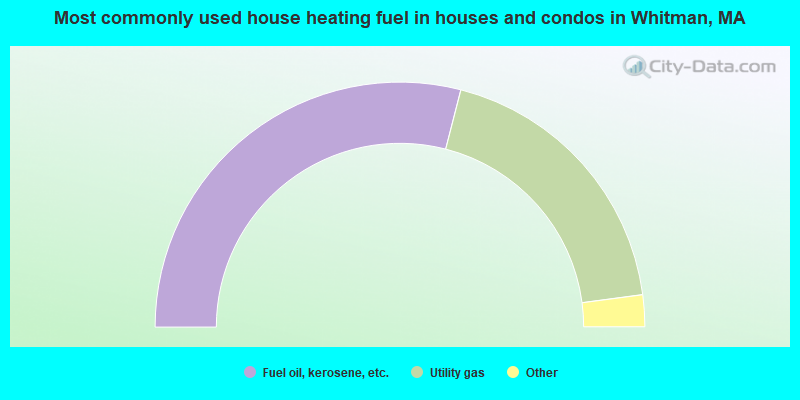
- 58.0%Fuel oil, kerosene, etc.
- 37.8%Utility gas
- 2.7%Electricity
- 0.6%Coal or coke
- 0.5%Bottled, tank, or LP gas
- 0.2%Other fuel
- 0.2%Wood
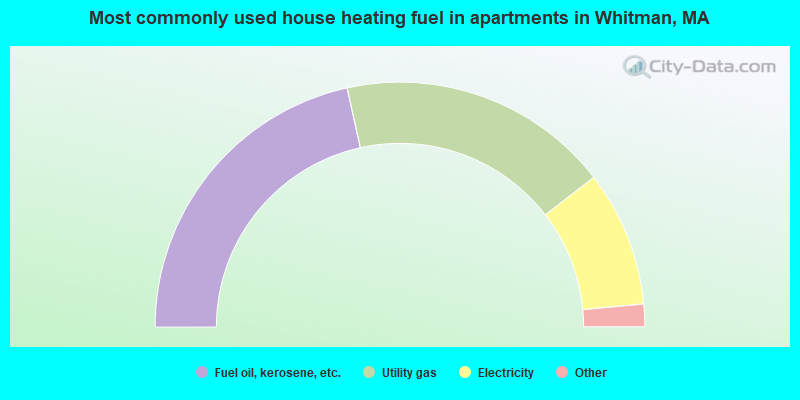
- 43.1%Fuel oil, kerosene, etc.
- 36.0%Utility gas
- 17.9%Electricity
- 2.0%Bottled, tank, or LP gas
- 0.6%No fuel used
- 0.4%Other fuel
Whitman compared to Massachusetts state average:
- Unemployed percentage significantly below state average.
- Black race population percentage significantly below state average.
- Hispanic race population percentage significantly below state average.
- Foreign-born population percentage significantly below state average.
- Length of stay since moving in significantly above state average.
- Number of rooms per house significantly below state average.
- House age significantly below state average.
- Percentage of population with a bachelor's degree or higher below state average.
Whitman on our top lists:
- #10 on the list of "Top 101 cities with largest percentage of females in industries: sewing, needlework, and piece goods stores (population 5,000+)"
- #32 on the list of "Top 101 cities with largest percentage of males in industries: clothing and accessories, including shoe, stores (population 5,000+)"
- #32 on the list of "Top 101 cities with largest percentage of females in industries: electronic shopping and mail-order houses (population 5,000+)"
- #35 on the list of "Top 101 cities with largest percentage of females in occupations: printing workers (population 5,000+)"
- #49 on the list of "Top 101 cities with largest percentage of males in occupations: printing workers (population 5,000+)"
- #51 on the list of "Top 101 cities with largest percentage of females in industries: health and personal care, except drug, stores (population 5,000+)"
- #54 on the list of "Top 101 cities with largest percentage of males in industries: printing and related support activities (population 5,000+)"
- #68 on the list of "Top 101 cities with largest percentage of males in occupations: painters and paperhangers (population 5,000+)"
- #69 on the list of "Top 101 cities with largest percentage of females in occupations: judges, magistrates, and other judicial workers (population 5,000+)"
- #71 on the list of "Top 101 cities with largest percentage of females in industries: metals and minerals, except petroleum, merchant wholesalers (population 5,000+)"
- #80 on the list of "Top 101 cities with largest percentage of males in occupations: electricians (population 5,000+)"
- #89 on the list of "Top 101 cities with largest percentage of females in industries: printing and related support activities (population 5,000+)"
- #91 on the list of "Top 101 cities with largest percentage of males in industries: book stores and news dealers (population 5,000+)"
- #91 on the list of "Top 101 cities with largest percentage of females in industries: fuel dealers (population 5,000+)"
- #94 on the list of "Top 101 cities with largest percentage of males in industries: metals and minerals, except petroleum, merchant wholesalers (population 5,000+)"
- #97 on the list of "Top 101 cities with largest percentage of males in occupations: librarians, curators, and archivists (population 5,000+)"
- #101 on the list of "Top 101 cities with largest percentage of females in industries: alcoholic beverages merchant wholesalers (population 5,000+)"
- #88 (02382) on the list of "Top 101 zip codes with the largest percentage of Irish first ancestries (pop 5,000+)"
- #18 on the list of "Top 101 counties with the highest percentage of residents that visited a dentist within the past year"
- #24 on the list of "Top 101 counties with the highest percentage of residents that smoked 100+ cigarettes in their lives"
- #35 on the list of "Top 101 counties with the largest decrease in the number of births per 1000 residents 2000-2006 to 2007-2013 (pop 50,000+)"
- #39 on the list of "Top 101 counties with the lowest percentage of residents that keep firearms around their homes"
- #39 on the list of "Top 101 counties with the lowest number of infant deaths per 1000 residents 2007-2013 (pop. 50,000+)"

|
|
Total of 54 patent applications in 2008-2024.