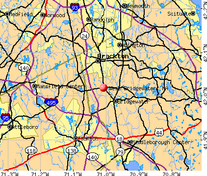
West Bridgewater, Massachusetts
Submit your own pictures of this town and show them to the world
- OSM Map
- General Map
- Google Map
- MSN Map
Population change since 2000: +4.3%
 |
| Males: 3,400 | |
| Females: 3,516 |
| Median resident age: | 43.9 years |
| Massachusetts median age: | 39.2 years |
Zip codes: 02379.
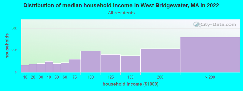
| West Bridgewater: | $103,809 |
| MA: | $94,488 |
Estimated per capita income in 2022: $51,786 (it was $23,701 in 2000)
West Bridgewater town income, earnings, and wages data
Estimated median house or condo value in 2022: $534,403 (it was $171,600 in 2000)
| West Bridgewater: | $534,403 |
| MA: | $534,700 |
Mean prices in 2022: all housing units: $585,203; detached houses: $620,100; townhouses or other attached units: $487,972; in 2-unit structures: $464,355; in 3-to-4-unit structures: $429,583; in 5-or-more-unit structures: $438,441; mobile homes: $207,706; occupied boats, rvs, vans, etc.: $17,153
West Bridgewater, MA residents, houses, and apartments details
Detailed information about poverty and poor residents in West Bridgewater, MA


- 6,47693.6%White alone
- 1211.7%Hispanic
- 1011.5%Black alone
- 931.3%Two or more races
- 751.1%Asian alone
- 430.6%Other race alone
- 70.1%American Indian alone
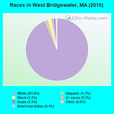
Races in West Bridgewater detailed stats: ancestries, foreign born residents, place of birth
According to our research of Massachusetts and other state lists, there were 4 registered sex offenders living in West Bridgewater, Massachusetts as of May 08, 2024.
The ratio of all residents to sex offenders in West Bridgewater is 1,729 to 1.
The ratio of registered sex offenders to all residents in this city is near the state average.
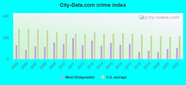
Type |
2009 |
2010 |
2011 |
2012 |
2013 |
2014 |
2015 |
2016 |
2017 |
2018 |
2019 |
2020 |
2021 |
2022 |
|---|---|---|---|---|---|---|---|---|---|---|---|---|---|---|
| Murders (per 100,000) | 0 (0.0) | 0 (0.0) | 0 (0.0) | 0 (0.0) | 0 (0.0) | 0 (0.0) | 0 (0.0) | 0 (0.0) | 1 (13.9) | 0 (0.0) | 0 (0.0) | 0 (0.0) | 0 (0.0) | 0 (0.0) |
| Rapes (per 100,000) | 0 (0.0) | 0 (0.0) | 2 (28.7) | 0 (0.0) | 1 (14.4) | 2 (28.5) | 3 (42.3) | 0 (0.0) | 1 (13.9) | 0 (0.0) | 1 (13.8) | 1 (13.2) | 0 (0.0) | 3 (37.1) |
| Robberies (per 100,000) | 5 (74.2) | 4 (57.8) | 5 (71.9) | 2 (28.5) | 4 (57.4) | 2 (28.5) | 1 (14.1) | 2 (28.2) | 1 (13.9) | 1 (13.8) | 0 (0.0) | 0 (0.0) | 0 (0.0) | 2 (24.7) |
| Assaults (per 100,000) | 8 (118.7) | 9 (130.1) | 9 (129.3) | 7 (99.8) | 18 (258.4) | 5 (71.2) | 12 (169.1) | 12 (169.1) | 15 (208.7) | 5 (68.8) | 8 (110.4) | 5 (66.1) | 18 (233.9) | 5 (61.8) |
| Burglaries (per 100,000) | 26 (385.8) | 39 (563.9) | 36 (517.4) | 31 (441.8) | 23 (330.2) | 34 (484.5) | 28 (394.6) | 19 (267.7) | 12 (166.9) | 7 (96.3) | 16 (220.8) | 9 (118.9) | 7 (91.0) | 23 (284.4) |
| Thefts (per 100,000) | 115 (1,706) | 92 (1,330) | 141 (2,026) | 111 (1,582) | 111 (1,593) | 71 (1,012) | 85 (1,198) | 91 (1,282) | 76 (1,057) | 70 (962.6) | 48 (662.3) | 49 (647.5) | 51 (662.7) | 57 (704.8) |
| Auto thefts (per 100,000) | 13 (192.9) | 9 (130.1) | 11 (158.1) | 8 (114.0) | 8 (114.8) | 6 (85.5) | 7 (98.6) | 20 (281.8) | 5 (69.6) | 9 (123.8) | 7 (96.6) | 8 (105.7) | 16 (207.9) | 10 (123.7) |
| Arson (per 100,000) | 2 (29.7) | 0 (0.0) | 0 (0.0) | 1 (14.3) | 2 (28.7) | 1 (14.2) | 2 (28.2) | 0 (0.0) | 0 (0.0) | 0 (0.0) | 1 (13.8) | 1 (13.2) | 1 (13.0) | 0 (0.0) |
| City-Data.com crime index | 156.7 | 146.5 | 200.3 | 131.8 | 176.4 | 126.8 | 155.3 | 134.8 | 144.4 | 73.0 | 82.8 | 66.5 | 96.3 | 107.5 |
The City-Data.com crime index weighs serious crimes and violent crimes more heavily. Higher means more crime, U.S. average is 246.1. It adjusts for the number of visitors and daily workers commuting into cities.
Crime rate in West Bridgewater detailed stats: murders, rapes, robberies, assaults, burglaries, thefts, arson
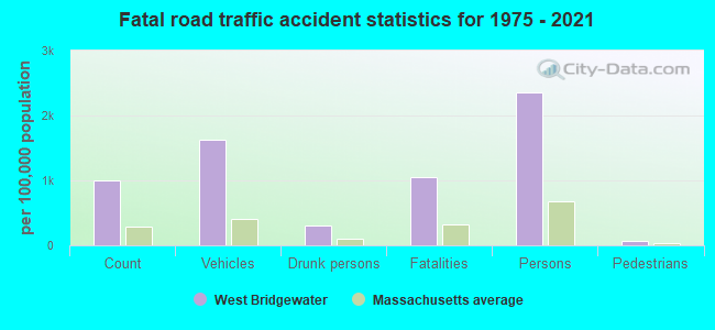
Full-time law enforcement employees in 2015, including police officers: 20 (19 officers - 19 male; 0 female).
| Officers per 1,000 residents here: | 2.68 |
| Massachusetts average: | 2.54 |
 Recent articles from our blog. Our writers, many of them Ph.D. graduates or candidates, create easy-to-read articles on a wide variety of topics.


 | Home Prices By Town for 2022 (190 replies) |
| November 2022...closed restaurants, bars and shops (201 replies) |
| 2021 Real Estate Observations (1729 replies) |
| Coronavirus in Massachusetts (18047 replies) |
| Boston Racial Stigma- is it "cool" to hate on Boston? (632 replies) |
| Where do Affluent Black Families live in MA? (222 replies) |
Latest news from West Bridgewater, MA collected exclusively by city-data.com from local newspapers, TV, and radio stations
Ancestries: Irish (31.5%), English (19.0%), Italian (16.5%), Swedish (6.8%), French (6.2%), German (5.0%).
Current Local Time: EST time zone
Incorporated in 1822
Elevation: 65 feet
Land area: 15.7 square miles.
Population density: 439 people per square mile (low).
238 residents are foreign born (1.7% Europe, 0.7% Latin America, 0.5% Asia).
| This town: | 3.6% |
| Massachusetts: | 12.2% |
| West Bridgewater town: | 1.4% ($2,355) |
| Massachusetts: | 1.3% ($2,336) |
Nearest city with pop. 50,000+: Brockton, MA  (4.2 miles , pop. 94,304).
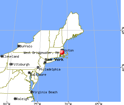
Nearest city with pop. 200,000+: Boston, MA (21.0 miles , pop. 589,141).
Nearest city with pop. 1,000,000+: Bronx, NY (168.9 miles , pop. 1,332,650).
Nearest cities:
), ), ), ), Latitude: 42.02 N, Longitude: 71.02 W

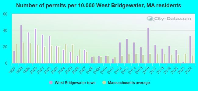
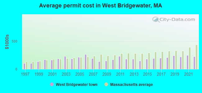
Single-family new house construction building permits:
- 2022: 22 buildings, average cost: $227,700
- 2021: 1 building, cost: $250,000
- 2020: 11 buildings, average cost: $222,200
- 2019: 14 buildings, average cost: $241,100
- 2018: 12 buildings, average cost: $211,600
- 2017: 15 buildings, average cost: $200,800
- 2016: 29 buildings, average cost: $191,100
- 2015: 13 buildings, average cost: $182,300
- 2014: 17 buildings, average cost: $146,700
- 2013: 20 buildings, average cost: $181,800
- 2012: 17 buildings, average cost: $180,400
- 2011: 4 buildings, average cost: $232,500
- 2010: 6 buildings, average cost: $171,500
- 2009: 6 buildings, average cost: $149,100
- 2008: 5 buildings, average cost: $139,300
- 2007: 11 buildings, average cost: $195,100
- 2006: 6 buildings, average cost: $264,700
- 2005: 9 buildings, average cost: $212,600
- 2004: 11 buildings, average cost: $190,400
- 2003: 14 buildings, average cost: $231,900
- 2002: 22 buildings, average cost: $189,600
- 2001: 23 buildings, average cost: $164,800
- 2000: 28 buildings, average cost: $169,900
- 1999: 25 buildings, average cost: $136,800
- 1998: 31 buildings, average cost: $106,400
- 1997: 10 buildings, average cost: $103,500
| Here: | 3.9% |
| Massachusetts: | 3.5% |
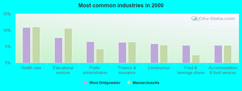
- Health care (10.9%)
- Educational services (7.8%)
- Public administration (6.5%)
- Finance & insurance (6.3%)
- Construction (5.9%)
- Food & beverage stores (5.4%)
- Accommodation & food services (5.4%)
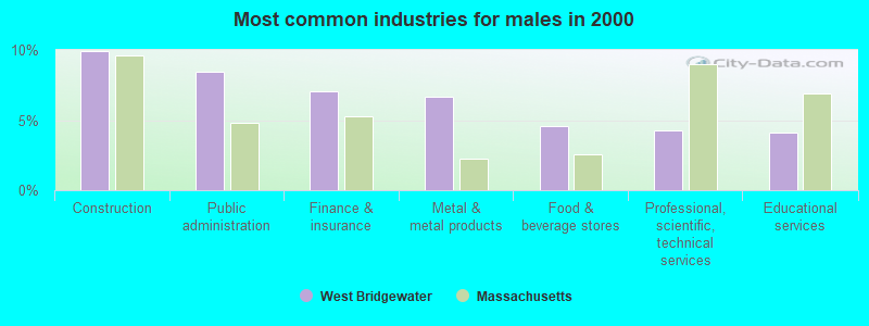
- Construction (9.9%)
- Public administration (8.4%)
- Finance & insurance (7.1%)
- Metal & metal products (6.7%)
- Food & beverage stores (4.6%)
- Professional, scientific, technical services (4.3%)
- Educational services (4.1%)
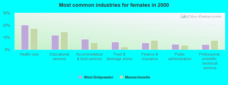
- Health care (20.1%)
- Educational services (11.8%)
- Accommodation & food services (8.6%)
- Food & beverage stores (6.2%)
- Finance & insurance (5.5%)
- Public administration (4.4%)
- Professional, scientific, technical services (4.2%)
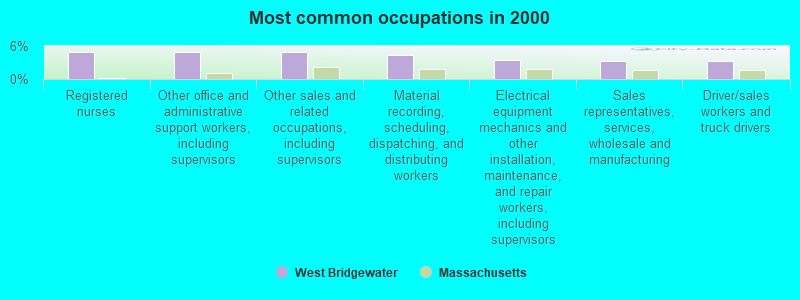
- Registered nurses (5.0%)
- Other office and administrative support workers, including supervisors (4.9%)
- Other sales and related occupations, including supervisors (4.9%)
- Material recording, scheduling, dispatching, and distributing workers (4.3%)
- Electrical equipment mechanics and other installation, maintenance, and repair workers, including supervisors (3.5%)
- Sales representatives, services, wholesale and manufacturing (3.3%)
- Driver/sales workers and truck drivers (3.3%)
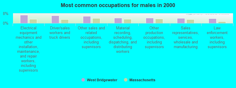
- Electrical equipment mechanics and other installation, maintenance, and repair workers, including supervisors (6.7%)
- Driver/sales workers and truck drivers (6.2%)
- Other sales and related occupations, including supervisors (5.9%)
- Material recording, scheduling, dispatching, and distributing workers (4.4%)
- Other production occupations, including supervisors (4.4%)
- Sales representatives, services, wholesale and manufacturing (4.2%)
- Law enforcement workers, including supervisors (3.8%)
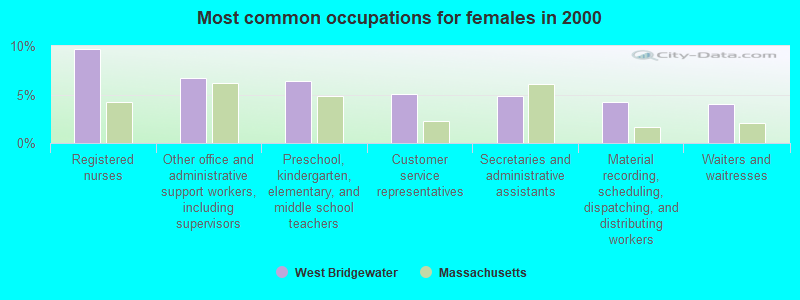
- Registered nurses (9.7%)
- Other office and administrative support workers, including supervisors (6.7%)
- Preschool, kindergarten, elementary, and middle school teachers (6.4%)
- Customer service representatives (5.0%)
- Secretaries and administrative assistants (4.9%)
- Material recording, scheduling, dispatching, and distributing workers (4.3%)
- Waiters and waitresses (4.1%)
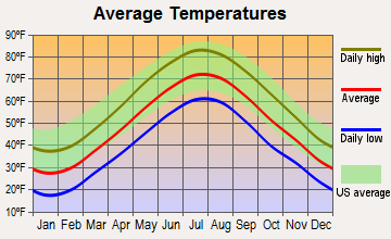
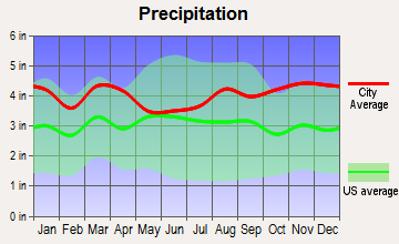
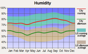
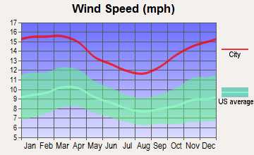
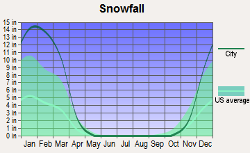
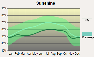
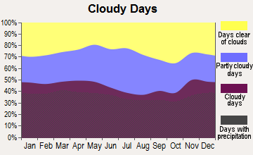
Average climate in West Bridgewater, Massachusetts
Based on data reported by over 4,000 weather stations
(lower is better)
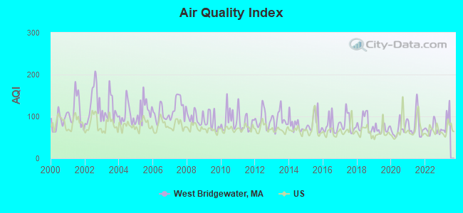
Air Quality Index (AQI) level in 2022 was 69.8. This is about average.
| City: | 69.8 |
| U.S.: | 72.6 |
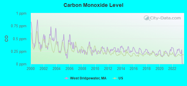
Carbon Monoxide (CO) [ppm] level in 2022 was 0.241. This is about average. Closest monitor was 15.6 miles away from the city center.
| City: | 0.241 |
| U.S.: | 0.251 |
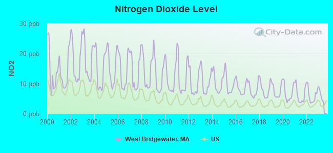
Nitrogen Dioxide (NO2) [ppb] level in 2022 was 6.15. This is worse than average. Closest monitor was 7.2 miles away from the city center.
| City: | 6.15 |
| U.S.: | 5.11 |
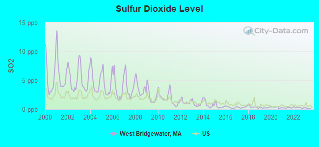
Sulfur Dioxide (SO2) [ppb] level in 2022 was 0.270. This is significantly better than average. Closest monitor was 4.0 miles away from the city center.
| City: | 0.270 |
| U.S.: | 1.515 |
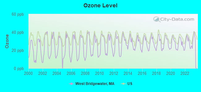
Ozone [ppb] level in 2022 was 28.8. This is about average. Closest monitor was 3.0 miles away from the city center.
| City: | 28.8 |
| U.S.: | 33.3 |
Particulate Matter (PM2.5) [µg/m3] level in 2022 was 8.42. This is about average. Closest monitor was 3.0 miles away from the city center.
| City: | 8.42 |
| U.S.: | 8.11 |
Lead (Pb) [µg/m3] level in 2001 was 0.0129. This is worse than average. Closest monitor was 4.0 miles away from the city center.
| City: | 0.0129 |
| U.S.: | 0.0093 |
Tornado activity:
West Bridgewater-area historical tornado activity is slightly below Massachusetts state average. It is 55% smaller than the overall U.S. average.
On 6/9/1953, a category F4 (max. wind speeds 207-260 mph) tornado 32.1 miles away from the West Bridgewater town center killed 90 people and injured 1228 people and caused between $50,000,000 and $500,000,000 in damages.
On 6/9/1953, a category F3 (max. wind speeds 158-206 mph) tornado 9.5 miles away from the town center injured 17 people and caused between $500,000 and $5,000,000 in damages.
Earthquake activity:
West Bridgewater-area historical earthquake activity is significantly above Massachusetts state average. It is 74% smaller than the overall U.S. average.On 10/7/1983 at 10:18:46, a magnitude 5.3 (5.1 MB, 5.3 LG, 5.1 ML, Class: Moderate, Intensity: VI - VII) earthquake occurred 214.7 miles away from West Bridgewater center
On 4/20/2002 at 10:50:47, a magnitude 5.3 (5.3 ML, Depth: 3.0 mi) earthquake occurred 218.8 miles away from West Bridgewater center
On 1/19/1982 at 00:14:42, a magnitude 4.7 (4.5 MB, 4.7 MD, 4.5 LG, Class: Light, Intensity: IV - V) earthquake occurred 106.4 miles away from the city center
On 10/16/2012 at 23:12:25, a magnitude 4.7 (4.7 ML, Depth: 10.0 mi) earthquake occurred 110.5 miles away from West Bridgewater center
On 4/20/2002 at 10:50:47, a magnitude 5.2 (5.2 MB, 4.2 MS, 5.2 MW, 5.0 MW) earthquake occurred 218.1 miles away from West Bridgewater center
On 8/22/1992 at 12:20:32, a magnitude 4.8 (4.8 MB, 3.8 MS, 4.7 LG, Depth: 6.2 mi) earthquake occurred 205.0 miles away from the city center
Magnitude types: regional Lg-wave magnitude (LG), body-wave magnitude (MB), duration magnitude (MD), local magnitude (ML), surface-wave magnitude (MS), moment magnitude (MW)
Natural disasters:
The number of natural disasters in Plymouth County (26) is a lot greater than the US average (15).Major Disasters (Presidential) Declared: 17
Emergencies Declared: 9
Causes of natural disasters: Floods: 11, Storms: 9, Hurricanes: 7, Snows: 3, Snowstorms: 3, Blizzards: 2, Winter Storms: 2, Heavy Rain: 1, Snowfall: 1, Tropical Storm: 1, Wind: 1 (Note: some incidents may be assigned to more than one category).

Main business address for: BOSTON BIOMEDICA INC (IN VITRO & IN VIVO DIAGNOSTIC SUBSTANCES).
Hospitals and medical centers in West Bridgewater:
- LIFECARE AT HOME OF MASSACHUSETTS (319 MANLEY STREET)
- LIFE CARE CENTER OF WEST BRIDGEWATER (765 WEST CENTER STREET)
Other hospitals and medical centers near West Bridgewater:
- SOUTHWOOD LONG TERM CARE - OLD (Nursing Home, about 3 miles away; BROCKTON, MA)
- PEDIATRIC SERVICES OF AMERICA HOME HEALTHCARE (Home Health Center, about 3 miles away; BROCKTON, MA)
- WOODRIDGE HOUSE NURSING AND REHAB CENTER (Nursing Home, about 3 miles away; BROCKTON, MA)
- WOODRIDGE HOUSE NURSING HOME (Nursing Home, about 3 miles away; BROCKTON, MA)
- KINDRED TRANSITIONAL CARE AND REHABILITATION-SACHEM (Nursing Home, about 4 miles away; EAST BRIDGEWATER, MA)
- BRIDGEWATER NURSING HOME (Nursing Home, about 4 miles away; BRIDGEWATER, MA)
- FORGE POND NURSING HOME (Nursing Home, about 4 miles away; EAST BRIDGEWATER, MA)
Operable nuclear power plant near West Bridgewater:
- 19 miles: Pilgrim in Plymouth, MA.
Colleges/universities with over 2000 students nearest to West Bridgewater:
- Bridgewater State University (about 4 miles; Bridgewater, MA; Full-time enrollment: 9,802)
- Massasoit Community College (about 5 miles; Brockton, MA; FT enrollment: 5,442)
- Stonehill College (about 5 miles; Easton, MA; FT enrollment: 2,563)
- Curry College (about 16 miles; Milton, MA; FT enrollment: 2,586)
- Quincy College (about 16 miles; Quincy, MA; FT enrollment: 3,184)
- University of Massachusetts-Boston (about 21 miles; Boston, MA; FT enrollment: 12,625)
- Bristol Community College (about 22 miles; Fall River, MA; FT enrollment: 5,707)
Public high school in West Bridgewater:
- WEST BRIDGEWATER JUNIOR/SENIOR (Students: 573, Location: 155 WEST CENTER, Grades: 7-12)
Public elementary/middle schools in West Bridgewater:
- HOWARD SCHOOL (Students: 274, Location: 70 HOWARD STREET, Grades: 4-6)
- ROSE L MACDONALD (Students: 255, Location: 1 STEPPING STONE DRIVE, Grades: 1-3)
Points of interest:
Notable locations in West Bridgewater: Center Shopping Plaza (A), Pine Valley Country Club (B), West Bridgewater Fire Department (C), West Bridgewater Public Library (D), West Bridgewater Town Hall (E). Display/hide their locations on the map
Shopping Center: West Shopping Center (1). Display/hide its location on the map
Main business address in West Bridgewater: BOSTON BIOMEDICA INC (A). Display/hide its location on the map
Churches in West Bridgewater include: West Bridgewater Baptist Church (A), Holy Tabernacle Church (B), First Church (C), Cochesett United Methodist Church (D), Saint Ann Parish Church (E). Display/hide their locations on the map
Cemeteries: Pleasant Hill Cemetery (1), Pine Hill Cemetery (2). Display/hide their locations on the map
Reservoirs and swamps: Mill Pond (A), West Meadow Brook Pond (B), Town River Reservoir (C), Flaggy Meadow (D). Display/hide their locations on the map
Streams, rivers, and creeks: West Meadow Brook (A), Queset Brook (B), Edson Brook (C), Coweeset Brook (D), Black Betty Brook (E). Display/hide their locations on the map
Park in West Bridgewater: West Meadow Wildlife Reservation (1). Display/hide its location on the map
Birthplace of: Lucius Roy Holbrook - Army general, John Reed, Jr. - Politician, Wally Snell - Baseball player and coach.
Drinking water stations with addresses in West Bridgewater and their reported violations in the past:
WEST BRIDGEWATER WATER DEPT (Population served: 6,815, Groundwater):Past health violations:Past monitoring violations:
- MCL, Monthly (TCR) - In OCT-2012, Contaminant: Coliform. Follow-up actions: St AO (w/o penalty) issued (FEB-21-2013), St Compliance achieved (FEB-21-2013)
- MCL, Monthly (TCR) - In OCT-2005, Contaminant: Coliform. Follow-up actions: St AO (w/o penalty) issued (MAY-18-2006), St Compliance achieved (MAY-18-2006)
- One minor monitoring violation
- 46 regular monitoring violations
| This town: | 2.6 people |
| Massachusetts: | 2.5 people |
| This town: | 70.9% |
| Whole state: | 63.0% |
| This town: | 6.8% |
| Whole state: | 7.0% |
Likely homosexual households (counted as self-reported same-sex unmarried-partner households)
- Lesbian couples: 0.3% of all households
- Gay men: 0.3% of all households
| This town: | 3.6% |
| Whole state: | 9.3% |
| This town: | 1.6% |
| Whole state: | 4.4% |
144 people in nursing homes in 2000
Banks with branches in West Bridgewater (2011 data):
- Bridgewater Savings Bank: West Center Street Branch at 120 West Center Street, branch established on 1947/12/15. Info updated 2010/02/03: Bank assets: $491.1 mil, Deposits: $376.9 mil, headquarters in Raynham, MA, positive income, Commercial Lending Specialization, 10 total offices, Holding Company: Bridgewater Financial, Mhc
- Mansfield Co-operative Bank: West Bridgewater Branch at 728 West Center Street, branch established on 2007/10/09. Info updated 2006/11/03: Bank assets: $358.2 mil, Deposits: $303.5 mil, headquarters in Mansfield, MA, positive income, Commercial Lending Specialization, 5 total offices
For population 15 years and over in West Bridgewater:
- Never married: 25.5%
- Now married: 55.7%
- Separated: 1.4%
- Widowed: 7.3%
- Divorced: 10.1%
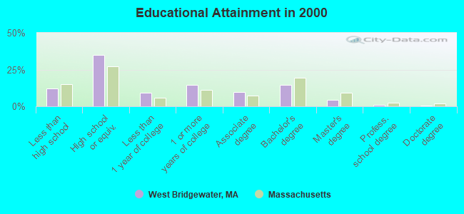
For population 25 years and over in West Bridgewater:
- High school or higher: 88.0%
- Bachelor's degree or higher: 20.2%
- Graduate or professional degree: 5.4%
- Unemployed: 3.1%
- Mean travel time to work (commute): 26.9 minutes
| Here: | 9.7 |
| Massachusetts average: | 13.1 |


Graphs represent county-level data. Detailed 2008 Election Results
Political contributions by individuals in West Bridgewater, MA
Religion statistics for West Bridgewater, MA (based on Plymouth County data)


| Religion | Adherents | Congregations |
|---|---|---|
| Catholic | 165,985 | 35 |
| Mainline Protestant | 23,724 | 91 |
| Evangelical Protestant | 13,159 | 96 |
| Other | 6,129 | 43 |
| Orthodox | 1,140 | 3 |
| Black Protestant | 611 | 5 |
| None | 284,171 | - |
Food Environment Statistics:
| Here: | 1.74 / 10,000 pop. |
| Massachusetts: | 1.98 / 10,000 pop. |
| Plymouth County: | 0.04 / 10,000 pop. |
| Massachusetts: | 0.05 / 10,000 pop. |
| Plymouth County: | 2.84 / 10,000 pop. |
| State: | 2.22 / 10,000 pop. |
| Plymouth County: | 2.20 / 10,000 pop. |
| Massachusetts: | 1.77 / 10,000 pop. |
| Plymouth County: | 7.37 / 10,000 pop. |
| State: | 8.76 / 10,000 pop. |
| Here: | 7.9% |
| State: | 8.1% |
| Plymouth County: | 21.7% |
| State: | 22.5% |
| Here: | 16.3% |
| State: | 16.5% |
5.54% of this county's 2020 resident taxpayers moved to other counties in 2021 ($85,482 average adjusted gross income)
| Here: | 5.54% |
| Massachusetts average: | 7.18% |
0.01% of residents moved to foreign countries ($80 average AGI)
Plymouth County: 0.01% Massachusetts average: 0.02%
Top counties to which taxpayers relocated from this county between 2020 and 2021:
| to Bristol County, MA | |
| to Norfolk County, MA | |
| to Suffolk County, MA |
| Businesses in West Bridgewater, MA | ||||
| Name | Count | Name | Count | |
|---|---|---|---|---|
| AT&T | 1 | McDonald's | 1 | |
| Decora Cabinetry | 2 | Penske | 1 | |
| Dunkin Donuts | 4 | Ryder Rental & Truck Leasing | 1 | |
| FedEx | 2 | Sprint Nextel | 1 | |
| H&R Block | 1 | Subway | 1 | |
| Lowe's | 1 | UPS | 1 | |
| MasterBrand Cabinets | 6 | |||
Strongest AM radio stations in West Bridgewater:
- WBET (1460 AM; 5 kW; BROCKTON, MA; Owner: KJI BROADCASTING, LLC)
- WBZ (1030 AM; 50 kW; BOSTON, MA; Owner: INFINITY BROADCASTING OPERATIONS, INC.)
- WEEI (850 AM; 50 kW; BOSTON, MA; Owner: ENTERCOM BOSTON LICENSE, LLC)
- WMSX (1410 AM; 1 kW; BROCKTON, MA; Owner: ANASTOS MEDIA GROUP, INC.)
- WRKO (680 AM; 50 kW; BOSTON, MA; Owner: ENTERCOM BOSTON LICENSE, LLC)
- WALE (990 AM; 50 kW; GREENVILLE, RI; Owner: NORTH AMERICAN BROADCASTING CO., INC.)
- WKOX (1200 AM; 50 kW; FRAMINGHAM, MA; Owner: CAPSTAR TX LIMITED PARTNERSHIP)
- WBIX (1060 AM; 40 kW; NATICK, MA; Owner: LANGER BROADCASTING CORPORATION)
- WWZN (1510 AM; 50 kW; BOSTON, MA; Owner: ROSE CITY RADIO CORPORATION)
- WAMG (890 AM; 25 kW; DEDHAM, MA; Owner: MEGA COMMUNICATIONS OF DEDHAM LICENSEE, LLC)
- WUNR (1600 AM; 20 kW; BROOKLINE, MA; Owner: CHAMPION BROADCASTING SYSTEMS, INC.)
- WRCA (1330 AM; 25 kW; WALTHAM, MA; Owner: WRCA LICENSE, LLC)
- WCRN (830 AM; 50 kW; WORCESTER, MA; Owner: CARTER BROADCASTING CORPORATION)
Strongest FM radio stations in West Bridgewater:
- WBOT (97.7 FM; BROCKTON, MA; Owner: RADIO ONE LICENSES, LLC)
- WWBB (101.5 FM; PROVIDENCE, RI; Owner: CLEAR CHANNEL BROADCASTING LICENSES, INC.)
- WBMX (98.5 FM; BOSTON, MA; Owner: INFINITY RADIO OPERATIONS INC.)
- WBOS (92.9 FM; BROOKLINE, MA; Owner: GREATER BOSTON RADIO, INC.)
- WXKS-FM (107.9 FM; MEDFORD, MA; Owner: AMFM RADIO LICENSES, L.L.C.)
- WJMN (94.5 FM; BOSTON, MA; Owner: AMFM RADIO LICENSES, L.L.C.)
- WCRB (102.5 FM; WALTHAM, MA; Owner: CHARLES RIVER BROADCASTING WCRB LICE)
- WTKK (96.9 FM; BOSTON, MA; Owner: GREATER BOSTON RADIO, INC.)
- WROR-FM (105.7 FM; FRAMINGHAM, MA; Owner: GREATER BOSTON RADIO, INC.)
- WMJX (106.7 FM; BOSTON, MA; Owner: GREATER BOSTON RADIO, INC.)
- WGBH (89.7 FM; BOSTON, MA; Owner: WGBH EDUCATIONAL FOUNDATION)
- WBUR-FM (90.9 FM; BOSTON, MA; Owner: TRUSTEES OF BOSTON UNIVERSITY)
- WBIM-FM (91.5 FM; BRIDGEWATER, MA; Owner: BRIDGEWATER STATE COLLEGE)
- WODS (103.3 FM; BOSTON, MA; Owner: INFINITY BROADCASTING OPERATIONS, INC.)
- WSNE-FM (93.3 FM; TAUNTON, MA; Owner: CAPSTAR TX LIMITED PARTNERSHIP)
- WBCN (104.1 FM; BOSTON, MA; Owner: HEMISPHERE BROADCASTING CORPORATION)
- WZLX (100.7 FM; BOSTON, MA; Owner: INFINITY BROADCASTING CORPORATION OF BOSTON)
- W267AI (101.3 FM; BOSTON, MA; Owner: MCC BROADCASTING COMPANY, INC.)
- WERS (88.9 FM; BOSTON, MA; Owner: EMERSON COLLEGE)
- WATD-FM (95.9 FM; MARSHFIELD, MA; Owner: MARSHFIELD BROADCASTING CO., INC.)
TV broadcast stations around West Bridgewater:
- WWDP (Channel 46; NORWELL, MA; Owner: NORWELL TELEVISION, LLC)
- WCVB-TV (Channel 5; BOSTON, MA; Owner: WCVB HEARST-ARGYLE TV, INC.)
- WLNE-TV (Channel 6; NEW BEDFORD, MA; Owner: FREEDOM BROADCASTING OF SOUTHERN NEW ENGLAND, INC.)
- WGBH-TV (Channel 2; BOSTON, MA; Owner: WGBH EDUCATIONAL FOUNDATION)
- WPRI-TV (Channel 12; PROVIDENCE, RI; Owner: TVL BROADCASTING OF RHODE ISLAND, LLC)
- WHDH-TV (Channel 7; BOSTON, MA; Owner: WHDH-TV)
- WMFP (Channel 62; LAWRENCE, MA; Owner: WSAH LICENSE, INC.)
- WSBK-TV (Channel 38; BOSTON, MA; Owner: VIACOM INC.)
- WLVI-TV (Channel 56; CAMBRIDGE, MA; Owner: WLVI, INC.)
- WNAC-TV (Channel 64; PROVIDENCE, RI; Owner: WNAC, LLC)
- WBZ-TV (Channel 4; BOSTON, MA; Owner: VIACOM INC.)
- WGBX-TV (Channel 44; BOSTON, MA; Owner: WGBH EDUCATIONAL FOUNDATION)
- WFXT (Channel 25; BOSTON, MA; Owner: FOX TELEVISION STATIONS INC.)
- WJAR (Channel 10; PROVIDENCE, RI; Owner: OUTLET BROADCASTING, INC.)
- WSBE-TV (Channel 36; PROVIDENCE, RI; Owner: RHODE ISLAND PUBLIC TELECOM. AUTHORITY)
- WLWC (Channel 28; NEW BEDFORD, MA; Owner: C-28 FCC LICENSEE SUBSIDIARY, LLC)
- WBPX (Channel 68; BOSTON, MA; Owner: PAXSON BOSTON-68 LICENSE, INC.)
- W40BO (Channel 40; BOSTON, MA; Owner: PAXSON COMMUNICATIONS LPTV, INC.)
- WTMU-LP (Channel 32; BOSTON, MA; Owner: ZGS BOSTON, INC.)
- WCEA-LP (Channel 58; BOSTON, MA; Owner: CHANNEL 19 TV CORPORATION)
- WUTF (Channel 66; MARLBOROUGH, MA; Owner: TELEFUTURA BOSTON LLC)
- WUNI (Channel 27; WORCESTER, MA; Owner: ENTRAVISION HOLDINGS, LLC)
- WPXQ (Channel 69; BLOCK ISLAND, RI; Owner: OCEAN STATE TELEVISION, L.L.C.)
- National Bridge Inventory (NBI) Statistics
- 14Number of bridges
- 89ft / 26.6mTotal length
- $26,970,000Total costs
- 295,639Total average daily traffic
- 15,212Total average daily truck traffic
- 413,382Total future (year 2031) average daily traffic
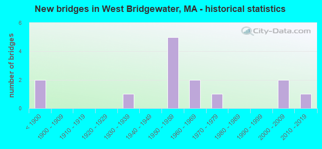
- New bridges - historical statistics
- 2Before 1900
- 11930-1939
- 51950-1959
- 21960-1969
- 11970-1979
- 22000-2009
- 12010-2019
FCC Registered Antenna Towers:
48 (See the full list of FCC Registered Antenna Towers in West Bridgewater)FCC Registered Private Land Mobile Towers:
3 (See the full list of FCC Registered Private Land Mobile Towers in West Bridgewater, MA)FCC Registered Broadcast Land Mobile Towers:
9 (See the full list of FCC Registered Broadcast Land Mobile Towers)FCC Registered Microwave Towers:
13 (See the full list of FCC Registered Microwave Towers in this town)FCC Registered Amateur Radio Licenses:
31 (See the full list of FCC Registered Amateur Radio Licenses in West Bridgewater)FAA Registered Aircraft:
3- Aircraft: CESSNA 150G (Category: Land, Seats: 2, Weight: Up to 12,499 Pounds, Speed: 90 mph), Engine: 4 Cycle
N-Number: 2967S, N2967S, N-2967S, Serial Number: 15066867, Year manufactured: 1967, Airworthiness Date: 06/14/1967, Certificate Issue Date: 09/10/2018
Registrant (Individual): Wayne M Dufault, Po Box 202, West Bridgewater, MA 02379 - Aircraft: CESSNA 150M (Category: Land, Seats: 2, Weight: Up to 12,499 Pounds, Speed: 81 mph), Engine: CONT MOTOR 0-200 SERIES (100 HP) (4 Cycle)
N-Number: 704AC, N704AC, N-704AC, Serial Number: 15078450, Year manufactured: 1976, Airworthiness Date: 07/16/1976, Certificate Issue Date: 05/26/2017
Registrant (Individual): Brian A Lutton, 590 N Elm St, West Bridgewater, MA 02379 - Aircraft: PIPER PA-32R-301 (Category: Land, Seats: 7, Weight: Up to 12,499 Pounds), Engine: LYCOMING IO-540 SER (300 HP) (Reciprocating)
N-Number: 966R, N966R, N-966R, Serial Number: 32R-8013133, Year manufactured: 1980, Airworthiness Date: 09/17/1980, Certificate Issue Date: 11/17/2010
Registrant (Corporation): Metropolitan Masonry Waterproofing & Restoration, 131 West St, West Bridgewater, MA 02379
2002 - 2018 National Fire Incident Reporting System (NFIRS) incidents
- Fire incident types reported to NFIRS in West Bridgewater, MA
- 22438.9%Outside Fires
- 16528.6%Structure Fires
- 16328.3%Mobile Property/Vehicle Fires
- 244.2%Other
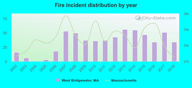 According to the data from the years 2002 - 2018 the average number of fires per year is 34. The highest number of reported fires - 56 took place in 2013, and the least - 0 in 2004. The data has a growing trend.
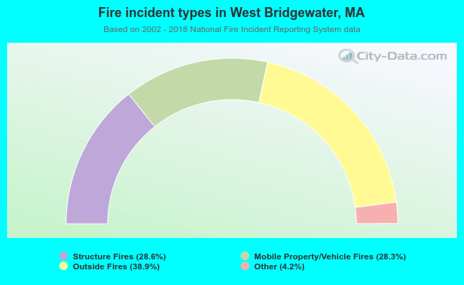 When looking into fire subcategories, the most incidents belonged to: Outside Fires (38.9%), and Structure Fires (28.6%).
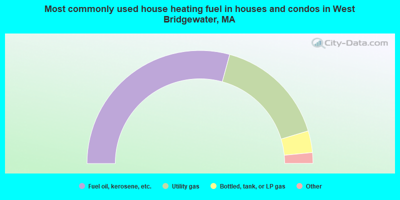
- 58.5%Fuel oil, kerosene, etc.
- 32.2%Utility gas
- 6.2%Bottled, tank, or LP gas
- 2.4%Electricity
- 0.5%Wood
- 0.2%Other fuel
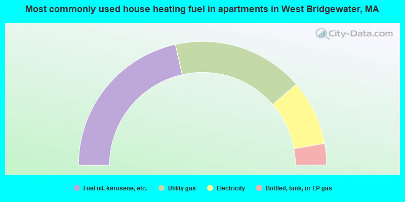
- 43.0%Fuel oil, kerosene, etc.
- 34.3%Utility gas
- 17.1%Electricity
- 5.6%Bottled, tank, or LP gas
West Bridgewater compared to Massachusetts state average:
- Unemployed percentage significantly below state average.
- Black race population percentage significantly below state average.
- Hispanic race population percentage significantly below state average.
- Median age above state average.
- Foreign-born population percentage significantly below state average.
- Renting percentage significantly below state average.
- Length of stay since moving in significantly above state average.
- Number of rooms per house significantly below state average.
- House age significantly below state average.
- Percentage of population with a bachelor's degree or higher below state average.
West Bridgewater on our top lists:
- #6 on the list of "Top 101 cities with largest percentage of females in industries: electronic shopping and mail-order houses (population 5,000+)"
- #8 on the list of "Top 101 cities with largest percentage of females in occupations: registered nurses (population 5,000+)"
- #14 on the list of "Top 101 cities with largest percentage of females in occupations: food and beverage serving workers except waiters/waitresses (population 5,000+)"
- #18 on the list of "Top 101 cities with largest percentage of males in industries: sewing, needlework, and piece goods stores (population 5,000+)"
- #25 on the list of "Top 101 cities with largest percentage of females in occupations: customer service representatives (population 5,000+)"
- #27 on the list of "Top 101 cities with largest percentage of males in industries: hardware, plumbing and heating equipment, and supplies merchant wholesalers (population 5,000+)"
- #35 on the list of "Top 101 cities with largest percentage of males in industries: electronic shopping and mail-order houses (population 5,000+)"
- #43 on the list of "Top 101 cities with largest percentage of males in occupations: other teachers and instructors, education, training, and library occupations (population 5,000+)"
- #44 on the list of "Top 101 cities with largest percentage of females in industries: food and beverage stores (population 5,000+)"
- #50 on the list of "Top 101 cities with largest percentage of males in industries: paper and paper products merchant wholesalers (population 5,000+)"
- #53 on the list of "Top 101 cities with largest percentage of males in industries: food and beverage stores (population 5,000+)"
- #55 on the list of "Top 101 cities with largest percentage of females in industries: fuel dealers (population 5,000+)"
- #56 on the list of "Top 101 cities with largest percentage of females in occupations: food processing workers (population 5,000+)"
- #60 on the list of "Top 101 cities with largest percentage of males in occupations: communications equipment operators (population 5,000+)"
- #69 on the list of "Top 101 cities with largest percentage of males in industries: apparel (population 5,000+)"
- #69 on the list of "Top 101 cities with largest percentage of males in industries: pharmacies and drug stores (population 5,000+)"
- #73 on the list of "Top 101 cities with largest percentage of females in industries: motor vehicles, parts and supplies merchant wholesalers (population 5,000+)"
- #77 on the list of "Top 101 cities with largest percentage of females in industries: beverage and tobacco products (population 5,000+)"
- #86 on the list of "Top 101 cities with largest percentage of males in industries: metal and metal products (population 5,000+)"
- #89 on the list of "Top 101 cities with largest percentage of males in industries: department and other general merchandise stores (population 5,000+)"
- #84 (02379) on the list of "Top 101 zip codes with the largest percentage of Lithuanian first ancestries (pop 5,000+)"
- #18 on the list of "Top 101 counties with the highest percentage of residents that visited a dentist within the past year"
- #24 on the list of "Top 101 counties with the highest percentage of residents that smoked 100+ cigarettes in their lives"
- #35 on the list of "Top 101 counties with the largest decrease in the number of births per 1000 residents 2000-2006 to 2007-2013 (pop 50,000+)"
- #39 on the list of "Top 101 counties with the lowest percentage of residents that keep firearms around their homes"
- #39 on the list of "Top 101 counties with the lowest number of infant deaths per 1000 residents 2007-2013 (pop. 50,000+)"

|
|
Total of 33 patent applications in 2008-2024.