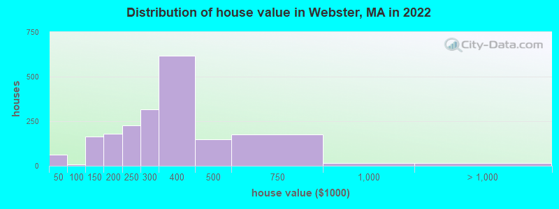
Estimated median house or condo value in 2022: $297,085 (it was $109,100 in 2000)
Webster:
$297,085
MA:
$534,700
Mean prices in 2022:all housing units: $287,566; detached houses: $287,548; townhouses or other attached units: $301,362; in 2-unit structures: $265,907; in 3-to-4-unit structures: $381,535; in 5-or-more-unit structures: $205,170; mobile homes: $184,874
Median gross rent in 2022: $1,046.
March 2022 cost of living index in Webster: 126.7 (high, U.S. average is 100)
Percentage of residents living in poverty in 2022: 18.0%
(13.2% for White Non-Hispanic residents, 27.8% for Black residents, 30.0% for Hispanic or Latino residents, 28.7% for other race residents, 29.8% for two or more races residents)
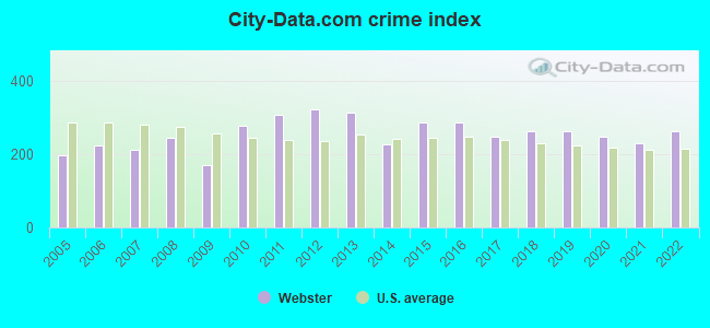
The City-Data.com crime index weighs serious crimes and violent crimes more heavily. Higher means more crime, U.S. average is 246.1. It adjusts for the number of visitors and daily workers commuting into cities.
Latest news from Webster, MA collected exclusively by city-data.com from local newspapers, TV, and radio stations
Ancestries: Polish (13.8%), Irish (5.2%), French (4.4%), American (4.1%), Portuguese (3.6%), French Canadian (3.5%).
Current Local Time: EST time zone
Incorporated in 1832
Elevation: 460 feet
Land area: 2.90 square miles.
Population density: 3,932 people per square mile (average).
1,237 residents are foreign born (3.4% Latin America, 2.2% Europe, 2.2% Africa, 1.8% Asia).
This place:
10.0%
Massachusetts:
17.6%
Median real estate property taxes paid for housing units with mortgages in 2022: $2,757 (0.9%) Median real estate property taxes paid for housing units with no mortgage in 2022: $2,541 (0.9%)
Nearest city with pop. 50,000+: Worcester, MA (15.6 miles , pop. 172,648).
Nearest city with pop. 200,000+: Boston, MA (44.5 miles , pop. 589,141).
Nearest city with pop. 1,000,000+: Bronx, NY (132.8 miles , pop. 1,332,650).
Air Quality Index (AQI) level in 2023 was 83.5. This is about average.
City:
83.5
U.S.:
72.6
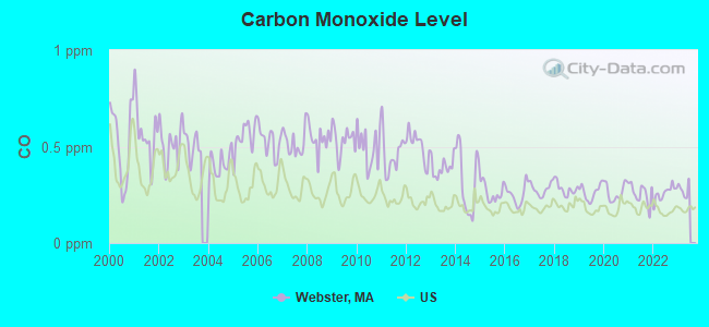
Carbon Monoxide (CO) [ppm] level in 2022 was 0.259. This is about average.Closest monitor was 15.0 miles away from the city center.
City:
0.259
U.S.:
0.251
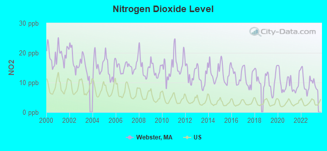
Nitrogen Dioxide (NO2) [ppb] level in 2022 was 10.1. This is significantly worse than average.Closest monitor was 9.1 miles away from the city center.
City:
10.1
U.S.:
5.1
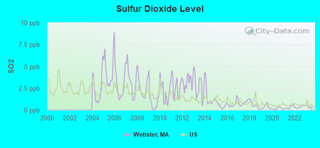
Sulfur Dioxide (SO2) [ppb] level in 2022 was 0.370. This is significantly better than average.Closest monitor was 9.1 miles away from the city center.
City:
0.370
U.S.:
1.515
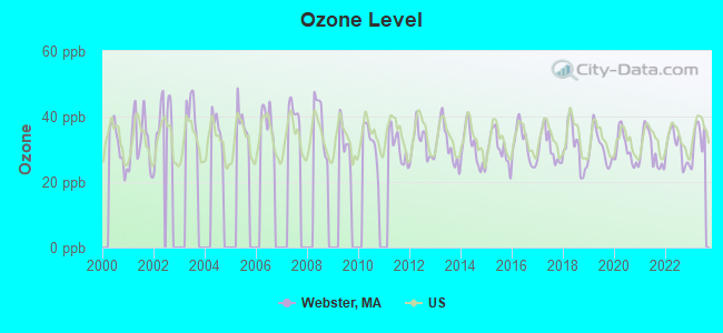
Ozone [ppb] level in 2023 was 33.2. This is about average.Closest monitor was 13.6 miles away from the city center.
City:
33.2
U.S.:
33.3
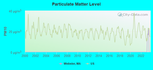
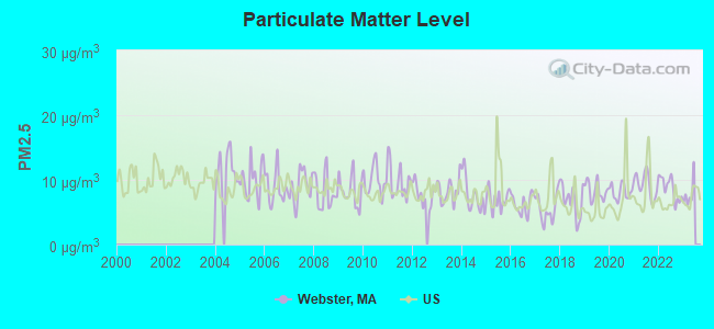
Particulate Matter (PM2.5) [µg/m3] level in 2022 was 8.71. This is about average.Closest monitor was 14.1 miles away from the city center.
City:
8.71
U.S.:
8.11
Tornado activity:
Webster-area historical tornado activity is slightly above Massachusetts state average. It is 24% smaller than the overall U.S. average.
On 6/9/1953, a category F4 (max. wind speeds 207-260 mph) tornado 25.2 miles away from the Webster place center killed 90 peopleand injured 1228 peopleand causedbetween $50,000,000 and $500,000,000 in damages.
On 6/9/1953, a category F3 (max. wind speeds 158-206 mph) tornado 10.0 miles away from the place center injured 17 peopleand causedbetween $500,000 and $5,000,000 in damages.
Earthquake activity:
Webster-area historical earthquake activity is significantly above Massachusetts state average. It is 72% smaller than the overall U.S. average.
On 10/7/1983 at 10:18:46, a magnitude 5.3 (5.1 MB, 5.3 LG, 5.1 ML, Class: Moderate, Intensity: VI - VII) earthquake occurred 181.4 miles away from Webster center On 4/20/2002 at 10:50:47, a magnitude 5.3 (5.3 ML, Depth: 3.0 mi) earthquake occurred 193.5 miles away from the city center On 4/20/2002 at 10:50:47, a magnitude 5.2 (5.2 MB, 4.2 MS, 5.2 MW, 5.0 MW) earthquake occurred 192.5 miles away from the city center On 1/19/1982 at 00:14:42, a magnitude 4.7 (4.5 MB, 4.7 MD, 4.5 LG, Class: Light, Intensity: IV - V) earthquake occurred 101.3 miles away from the city center On 10/16/2012 at 23:12:25, a magnitude 4.7 (4.7 ML, Depth: 10.0 mi) earthquake occurred 123.7 miles away from the city center On 8/22/1992 at 12:20:32, a magnitude 4.8 (4.8 MB, 3.8 MS, 4.7 LG, Depth: 6.2 mi) earthquake occurred 219.4 miles away from the city center Magnitude types: regional Lg-wave magnitude (LG), body-wave magnitude (MB), duration magnitude (MD), local magnitude (ML), surface-wave magnitude (MS), moment magnitude (MW)
Natural disasters:
The number of natural disasters in Worcester County (27) is a lot greater than the US average (15). Major Disasters (Presidential) Declared: 15 Emergencies Declared: 12
Causes of natural disasters: Floods: 9, Storms: 8, Hurricanes: 6, Snowstorms: 5, Winter Storms: 4, Blizzards: 2, Snows: 2, Fire: 1, Heavy Rain: 1, Snowfall: 1, Tornado: 1, Wind: 1 (Note: some incidents may be assigned to more than one category).
Main business address for: COMMERCE GROUP INC /MA (FIRE, MARINE & CASUALTY INSURANCE).
CHESTER C. CORBIN PUBLIC LIBRARY (Operating income: $463,877; Location: 2 LAKE ST.; 33,854 books; 930 e-books; 2,528 audio materials; 2,379 video materials; 8 local licensed databases; 34 state licensed databases; 65 print serial subscriptions)
User-submitted facts and corrections:
new Webster Middle School replaces Anthony J. Sitkowski Elementary School in Fall, 2005.
Notable locations in Webster: Webster Emergency Medical Services (A), Webster Fire Department (B), Webster Fire Department Station 1 Headquarters (C), Chester C Corbin Public Library (D). Display/hide their locations on the map
Churches in Webster include: Saint Louis Church (A), Saint Joseph Church (B), Saint Anne Church (C), First Baptist Church (D), Faith Assembly of God Church (E), Emanuel Lutheran Church (F), Church of Reconciliation (G), Christ Federated United Church (H). Display/hide their locations on the map
Birthplace of: Richard Lindzen - Physicist, William Slater Brown - Centenarian, Frank Gilmore - Baseball player, George Derby (baseball) - Baseball player, George R. Stobbs - Politician, Mike Sullivan (outfielder) - Baseball player, Lyman T. Tingier - Politician.
Worcester County has a predicted average indoor radon screening level greater than 4 pCi/L (pico curies per liter) - Highest Potential
Drinking water stations with addresses in Webster and their reported violations in the past:
WEBSTER WATER DEPARTMENT (Population served: 15,667, Groundwater):
Past health violations:
MCL, Monthly (TCR) - In MAY-2014, Contaminant: Coliform. Follow-up actions: St AO (w/o penalty) issued (JUN-24-2014), St Compliance achieved (JUN-24-2014)
MCL, Monthly (TCR) - In SEP-2013, Contaminant: Coliform. Follow-up actions: St AO (w/o penalty) issued (NOV-07-2013), St Compliance achieved (NOV-07-2013)
MCL, Monthly (TCR) - In JUL-2013, Contaminant: Coliform. Follow-up actions: St AO (w/o penalty) issued (AUG-26-2013)
MCL, Monthly (TCR) - In JAN-2013, Contaminant: Coliform. Follow-up actions: St AO (w/o penalty) issued (MAR-26-2013), St Compliance achieved (JUN-04-2013)
MCL, Monthly (TCR) - In JUL-2010, Contaminant: Coliform. Follow-up actions: St AO (w/o penalty) issued (AUG-24-2010), St Compliance achieved (AUG-24-2010)
MCL, Monthly (TCR) - In JUN-2010, Contaminant: Coliform. Follow-up actions: St AO (w/o penalty) issued (AUG-24-2010)
MCL, Monthly (TCR) - In SEP-2009, Contaminant: Coliform. Follow-up actions: St AO (w/o penalty) issued (DEC-23-2009)
Past monitoring violations:
Monitoring and Reporting (DBP) - Between OCT-2012 and DEC-2012, Contaminant: Chlorine. Follow-up actions: St AO (w/o penalty) issued (FEB-27-2013), St Compliance achieved (FEB-27-2013)
Follow-up Or Routine LCR Tap M/R - In JUL-01-2011, Contaminant: Lead and Copper Rule. Follow-up actions: St AO (w/o penalty) issued (FEB-29-2012), St Compliance achieved (JUL-31-2012)
Follow-up Or Routine LCR Tap M/R - In JUL-01-2009, Contaminant: Lead and Copper Rule. Follow-up actions: St AO (w/o penalty) issued (DEC-14-2009), St Compliance achieved (AUG-25-2010)
Monitoring and Reporting (DBP) - Between JUL-2009 and SEP-2009, Contaminant: Chlorine. Follow-up actions: St AO (w/o penalty) issued (DEC-14-2009), St Compliance achieved (AUG-25-2010)
Monitoring and Reporting (DBP) - Between APR-2009 and JUN-2009, Contaminant: Chlorine. Follow-up actions: St AO (w/o penalty) issued (SEP-03-2009), St Compliance achieved (DEC-07-2009)
One minor monitoring violation
5 regular monitoring violations
5 other older monitoring violations
TORIA HEIGHTS CONDOMINIUM (Address: 35 EAST MAIN ST , Population served: 160, Groundwater):
Past monitoring violations:
One routine major monitoring violation
28 regular monitoring violations
Average household size:
This place:
2.3 people
Massachusetts:
2.5 people
Percentage of family households:
This place:
57.0%
Whole state:
63.0%
Percentage of households with unmarried partners:
This place:
10.5%
Whole state:
7.0%
Likely homosexual households (counted as self-reported same-sex unmarried-partner households)
Lesbian couples: 0.2% of all households
Gay men: 0.1% of all households
People in group quarters in Webster in 2010:
299 people in nursing facilities/skilled-nursing facilities
11 people in group homes intended for adults
6 people in other noninstitutional facilities
259 people in nursing homes in 2000
8 people in religious group quarters in 2000
Banks with branches in Webster (2011 data):
Hometown Bank, A Cooperative Bank: at 218 Main Street, branch established on 1889/01/01. Info updated 2011/04/11: Bank assets: $301.7 mil, Deposits: $250.6 mil, local headquarters, positive income, Commercial Lending Specialization, 5 total offices
Webster Five Cents Savings Bank: at 136 Thompson Road, branch established on 1868/03/15. Info updated 2009/05/20: Bank assets: $558.9 mil, Deposits: $465.4 mil, local headquarters, positive income, Commercial Lending Specialization, 8 total offices, Holding Company: Webfive Mhc
Sovereign Bank, National Association: Webster Branch at 206 Main Street, branch established on 1965/10/01. Info updated 2012/01/31: Bank assets: $78,146.9 mil, Deposits: $48,042.9 mil, headquarters in Wilmington, DE, positive income, Commercial Lending Specialization, 718 total offices, Holding Company: Banco Santander, S.A.
Commerce Bank & Trust Company: Webster Branch at 25 Worcester Road, branch established on 1972/04/10. Info updated 2006/10/06: Bank assets: $1,410.8 mil, Deposits: $1,187.6 mil, headquarters in Worcester, MA, positive income, Commercial Lending Specialization, 14 total offices, Holding Company: Commerce Bancshares Corp.
Southbridge Savings Bank: Webster Branch at 86 Worcester Road, branch established on 1998/10/16. Info updated 2008/10/14: Bank assets: $419.3 mil, Deposits: $329.4 mil, headquarters in Southbridge, MA, positive income, Commercial Lending Specialization, 9 total offices, Holding Company: Green Valley Bancorp, Mhc
First Niagara Bank, National Association: Webster Lake Branch at 115 East Main Street, branch established on 2003/09/15. Info updated 2011/06/09: Bank assets: $32,750.6 mil, Deposits: $19,595.4 mil, headquarters in Buffalo, NY, positive income, Commercial Lending Specialization, 351 total offices, Holding Company: First Niagara Financial Group, Inc.
Religion statistics for Webster, MA (based on Worcester County data)
Religion
Adherents
Congregations
Catholic
306,925
118
Mainline Protestant
43,326
171
Evangelical Protestant
37,511
203
Other
18,931
69
Orthodox
7,935
15
Black Protestant
497
6
None
383,427
-
Source: Clifford Grammich, Kirk Hadaway, Richard Houseal, Dale E.Jones, Alexei Krindatch, Richie Stanley and Richard H.Taylor. 2012. 2010 U.S.Religion Census: Religious Congregations & Membership Study. Association of Statisticians of American Religious Bodies. Jones, Dale E., et al. 2002. Congregations and Membership in the United States 2000. Nashville, TN: Glenmary Research Center. Graphs represent county-level data
Aircraft: CESSNA A152 (Category: Land, Seats: 2, Weight: Up to 12,499 Pounds), Engine: LYCOMING 0-235 SERIES (115 HP) (Reciprocating) N-Number: 4799A, N4799A, N-4799A, Serial Number: A1520893, Year manufactured: 1979, Airworthiness Date: 08/15/1979, Certificate Issue Date: 07/15/2019 Registrant (LLC): New England Aircraft Detailing LLC, Po Box 1252, Webster, MA 01570
Aircraft: COMMANDER AIRCRAFT CO 114-B (Category: Land, Seats: 4, Weight: Up to 12,499 Pounds), Engine: LYCOMING IO-540 SER (300 HP) (Reciprocating) N-Number: 68CA, N68CA, N-68CA, Serial Number: 14560, Year manufactured: 1992, Airworthiness Date: 11/10/1992, Certificate Issue Date: 07/30/1999 Registrant (Individual): Robert Gomes, 86 Union Point Rd, Webster, MA 01570
Aircraft: PIPER PA-28-140 (Category: Land, Seats: 4, Weight: Up to 12,499 Pounds, Speed: 107 mph), Engine: LYCOMING 0-320 SERIES (180 HP) (Reciprocating) N-Number: 1695T, N1695T, N-1695T, Serial Number: 28-7125012, Year manufactured: 1970, Airworthiness Date: 08/21/1970, Certificate Issue Date: 04/15/1988 Registrant (Individual): Gordon Marko, 3 Deslauriers Ave, Webster, MA 01570 Deregistered:Cancel Date: 07/10/2020
Aircraft: PZL WARSZAWA-OKECE PZL-104 WILGA 35 (Category: Land, Weight: Up to 12,499 Pounds), Engine: AMA/EXPR UNKNOWN ENG (Reciprocating) N-Number: 86PL, N86PL, N-86PL, Serial Number: 48043, Year manufactured: 1969, Airworthiness Date: 07/08/2004, Certificate Issue Date: 04/13/2005 Registrant (Individual): John A Lipski, Po Box 297, Webster, MA 01570
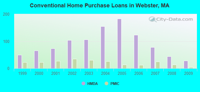
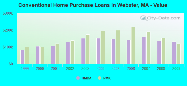
Home Mortgage Disclosure Act Aggregated Statistics For Year 2009 (Based on 2 full and 1 partial tracts)
A) FHA, FSA/RHS & VA Home Purchase Loans
B) Conventional Home Purchase Loans
C) Refinancings
D) Home Improvement Loans
E) Loans on Dwellings For 5+ Families
F) Non-occupant Loans on < 5 Family Dwellings (A B C & D)
G) Loans On Manufactured Home Dwelling (A B C & D)
Number
Average Value
Number
Average Value
Number
Average Value
Number
Average Value
Number
Average Value
Number
Average Value
Number
Average Value
LOANS ORIGINATED
24
$157,676
28
$133,041
95
$173,733
12
$74,341
4
$336,000
16
$187,763
1
$38,000
APPLICATIONS APPROVED, NOT ACCEPTED
3
$194,633
2
$82,895
6
$163,673
2
$40,250
0
$0
3
$112,263
0
$0
APPLICATIONS DENIED
5
$137,638
4
$138,630
34
$180,573
3
$46,333
1
$290,000
2
$92,500
0
$0
APPLICATIONS WITHDRAWN
4
$151,700
3
$168,817
26
$179,928
1
$137,000
1
$70,000
3
$119,670
0
$0
FILES CLOSED FOR INCOMPLETENESS
0
$0
1
$99,580
6
$150,863
0
$0
0
$0
0
$0
0
$0
Aggregated Statistics For Year 2008 (Based on 2 full and 1 partial tracts)
A) FHA, FSA/RHS & VA Home Purchase Loans
B) Conventional Home Purchase Loans
C) Refinancings
D) Home Improvement Loans
E) Loans on Dwellings For 5+ Families
F) Non-occupant Loans on < 5 Family Dwellings (A B C & D)
G) Loans On Manufactured Home Dwelling (A B C & D)
Number
Average Value
Number
Average Value
Number
Average Value
Number
Average Value
Number
Average Value
Number
Average Value
Number
Average Value
LOANS ORIGINATED
25
$177,798
44
$137,217
79
$165,801
11
$70,849
3
$659,857
26
$161,013
1
$46,000
APPLICATIONS APPROVED, NOT ACCEPTED
2
$224,000
3
$134,667
11
$183,455
1
$110,000
1
$215,000
3
$189,667
0
$0
APPLICATIONS DENIED
6
$172,778
8
$139,426
47
$203,079
9
$72,840
1
$375,000
11
$146,065
0
$0
APPLICATIONS WITHDRAWN
3
$168,333
5
$171,110
16
$172,390
3
$103,030
1
$280,000
0
$0
0
$0
FILES CLOSED FOR INCOMPLETENESS
0
$0
1
$134,720
9
$196,641
2
$176,500
0
$0
1
$103,000
0
$0
Aggregated Statistics For Year 2007 (Based on 2 full and 1 partial tracts)
A) FHA, FSA/RHS & VA Home Purchase Loans
B) Conventional Home Purchase Loans
C) Refinancings
D) Home Improvement Loans
E) Loans on Dwellings For 5+ Families
F) Non-occupant Loans on < 5 Family Dwellings (A B C & D)
G) Loans On Manufactured Home Dwelling (A B C & D)
Number
Average Value
Number
Average Value
Number
Average Value
Number
Average Value
Number
Average Value
Number
Average Value
Number
Average Value
LOANS ORIGINATED
3
$265,667
78
$160,801
127
$161,877
28
$53,726
13
$230,429
21
$152,049
1
$60,000
APPLICATIONS APPROVED, NOT ACCEPTED
0
$0
9
$145,729
24
$182,590
5
$86,218
0
$0
3
$90,143
0
$0
APPLICATIONS DENIED
2
$256,770
24
$153,171
163
$194,070
23
$49,228
6
$284,667
14
$172,669
0
$0
APPLICATIONS WITHDRAWN
1
$267,990
6
$170,993
58
$175,947
2
$94,245
0
$0
2
$154,000
0
$0
FILES CLOSED FOR INCOMPLETENESS
0
$0
1
$172,070
27
$210,830
1
$5,860
3
$312,667
0
$0
0
$0
Aggregated Statistics For Year 2006 (Based on 2 full and 1 partial tracts)
A) FHA, FSA/RHS & VA Home Purchase Loans
B) Conventional Home Purchase Loans
C) Refinancings
D) Home Improvement Loans
E) Loans on Dwellings For 5+ Families
F) Non-occupant Loans on < 5 Family Dwellings (A B C & D)
G) Loans On Manufactured Home Dwelling (A B C & D)
Number
Average Value
Number
Average Value
Number
Average Value
Number
Average Value
Number
Average Value
Number
Average Value
Number
Average Value
LOANS ORIGINATED
5
$232,450
123
$142,438
192
$157,365
43
$71,342
10
$281,800
41
$163,912
1
$15,000
APPLICATIONS APPROVED, NOT ACCEPTED
0
$0
19
$136,465
35
$156,936
9
$52,760
2
$327,000
10
$158,416
0
$0
APPLICATIONS DENIED
1
$248,000
42
$150,097
166
$177,483
32
$91,082
1
$205,000
16
$167,331
2
$29,820
APPLICATIONS WITHDRAWN
0
$0
22
$138,245
123
$176,666
9
$124,141
1
$150,000
12
$151,242
0
$0
FILES CLOSED FOR INCOMPLETENESS
0
$0
4
$116,775
34
$205,342
2
$14,820
0
$0
1
$204,000
2
$108,550
Aggregated Statistics For Year 2005 (Based on 2 full and 1 partial tracts)
A) FHA, FSA/RHS & VA Home Purchase Loans
B) Conventional Home Purchase Loans
C) Refinancings
D) Home Improvement Loans
E) Loans on Dwellings For 5+ Families
F) Non-occupant Loans on < 5 Family Dwellings (A B C & D)
G) Loans On Manufactured Home Dwelling (A B C & D)
Number
Average Value
Number
Average Value
Number
Average Value
Number
Average Value
Number
Average Value
Number
Average Value
Number
Average Value
LOANS ORIGINATED
5
$182,878
183
$147,588
259
$163,183
27
$95,052
14
$291,189
47
$181,718
1
$72,000
APPLICATIONS APPROVED, NOT ACCEPTED
1
$243,000
15
$161,244
37
$178,616
5
$112,510
0
$0
4
$255,000
0
$0
APPLICATIONS DENIED
0
$0
50
$146,843
145
$169,260
13
$36,734
6
$163,333
17
$148,165
3
$48,333
APPLICATIONS WITHDRAWN
0
$0
59
$169,654
117
$159,395
12
$171,615
8
$241,375
16
$127,563
0
$0
FILES CLOSED FOR INCOMPLETENESS
0
$0
10
$179,973
43
$190,151
0
$0
0
$0
8
$203,354
0
$0
Aggregated Statistics For Year 2004 (Based on 2 full and 1 partial tracts)
A) FHA, FSA/RHS & VA Home Purchase Loans
B) Conventional Home Purchase Loans
C) Refinancings
D) Home Improvement Loans
E) Loans on Dwellings For 5+ Families
F) Non-occupant Loans on < 5 Family Dwellings (A B C & D)
G) Loans On Manufactured Home Dwelling (A B C & D)
Number
Average Value
Number
Average Value
Number
Average Value
Number
Average Value
Number
Average Value
Number
Average Value
Number
Average Value
LOANS ORIGINATED
12
$211,133
155
$153,139
241
$150,840
39
$77,358
10
$245,910
48
$173,116
1
$8,000
APPLICATIONS APPROVED, NOT ACCEPTED
3
$199,667
17
$172,117
33
$146,048
4
$84,325
0
$0
6
$190,667
3
$65,000
APPLICATIONS DENIED
1
$205,000
40
$117,456
113
$148,940
26
$56,047
3
$253,333
10
$144,326
4
$91,750
APPLICATIONS WITHDRAWN
0
$0
22
$143,173
71
$150,186
10
$69,107
2
$214,645
10
$119,196
0
$0
FILES CLOSED FOR INCOMPLETENESS
0
$0
9
$218,333
54
$163,894
1
$141,000
0
$0
0
$0
0
$0
Aggregated Statistics For Year 2003 (Based on 2 full and 1 partial tracts)
A) FHA, FSA/RHS & VA Home Purchase Loans
B) Conventional Home Purchase Loans
C) Refinancings
D) Home Improvement Loans
E) Loans on Dwellings For 5+ Families
F) Non-occupant Loans on < 5 Family Dwellings (A B C & D)
Number
Average Value
Number
Average Value
Number
Average Value
Number
Average Value
Number
Average Value
Number
Average Value
LOANS ORIGINATED
13
$189,580
106
$152,978
402
$126,229
9
$34,891
9
$259,433
59
$123,044
APPLICATIONS APPROVED, NOT ACCEPTED
1
$190,000
18
$144,339
56
$126,539
3
$32,823
0
$0
5
$160,654
APPLICATIONS DENIED
2
$120,500
30
$134,427
138
$129,984
12
$21,732
1
$370,000
9
$124,222
APPLICATIONS WITHDRAWN
1
$238,000
14
$145,884
98
$129,738
3
$21,000
0
$0
8
$104,251
FILES CLOSED FOR INCOMPLETENESS
0
$0
3
$128,350
9
$141,439
0
$0
0
$0
0
$0
Aggregated Statistics For Year 2002 (Based on 2 full and 1 partial tracts)
A) FHA, FSA/RHS & VA Home Purchase Loans
B) Conventional Home Purchase Loans
C) Refinancings
D) Home Improvement Loans
E) Loans on Dwellings For 5+ Families
F) Non-occupant Loans on < 5 Family Dwellings (A B C & D)
Number
Average Value
Number
Average Value
Number
Average Value
Number
Average Value
Number
Average Value
Number
Average Value
LOANS ORIGINATED
25
$169,077
104
$129,857
246
$111,141
12
$23,008
8
$196,864
41
$102,888
APPLICATIONS APPROVED, NOT ACCEPTED
1
$180,120
6
$129,177
33
$105,686
2
$16,645
0
$0
3
$129,000
APPLICATIONS DENIED
4
$181,875
19
$112,545
71
$106,796
9
$42,583
0
$0
10
$113,337
APPLICATIONS WITHDRAWN
2
$116,500
11
$136,224
66
$107,529
2
$26,920
0
$0
4
$101,055
FILES CLOSED FOR INCOMPLETENESS
1
$73,950
4
$94,490
18
$112,869
1
$55,000
1
$189,000
1
$162,000
Aggregated Statistics For Year 2001 (Based on 2 full and 1 partial tracts)
A) FHA, FSA/RHS & VA Home Purchase Loans
B) Conventional Home Purchase Loans
C) Refinancings
D) Home Improvement Loans
E) Loans on Dwellings For 5+ Families
F) Non-occupant Loans on < 5 Family Dwellings (A B C & D)
Number
Average Value
Number
Average Value
Number
Average Value
Number
Average Value
Number
Average Value
Number
Average Value
LOANS ORIGINATED
31
$127,911
74
$106,671
147
$100,602
20
$32,606
8
$160,310
20
$96,240
APPLICATIONS APPROVED, NOT ACCEPTED
5
$139,800
13
$93,788
17
$97,144
4
$18,250
0
$0
4
$111,668
APPLICATIONS DENIED
2
$124,500
16
$80,385
56
$97,779
11
$33,468
0
$0
3
$137,000
APPLICATIONS WITHDRAWN
3
$142,663
11
$112,704
54
$92,860
8
$33,225
0
$0
4
$101,058
FILES CLOSED FOR INCOMPLETENESS
1
$91,000
2
$87,360
5
$88,120
1
$10,000
0
$0
1
$81,000
Aggregated Statistics For Year 2000 (Based on 2 full and 1 partial tracts)
A) FHA, FSA/RHS & VA Home Purchase Loans
B) Conventional Home Purchase Loans
C) Refinancings
D) Home Improvement Loans
E) Loans on Dwellings For 5+ Families
F) Non-occupant Loans on < 5 Family Dwellings (A B C & D)
Number
Average Value
Number
Average Value
Number
Average Value
Number
Average Value
Number
Average Value
Number
Average Value
LOANS ORIGINATED
34
$107,647
65
$104,320
58
$77,592
16
$23,589
3
$114,993
15
$124,442
APPLICATIONS APPROVED, NOT ACCEPTED
4
$94,872
6
$81,198
10
$67,157
5
$29,398
0
$0
1
$88,000
APPLICATIONS DENIED
3
$100,130
12
$87,590
51
$64,803
16
$24,348
1
$270,000
2
$97,500
APPLICATIONS WITHDRAWN
3
$79,413
7
$60,264
29
$65,042
2
$49,145
1
$118,000
5
$56,234
FILES CLOSED FOR INCOMPLETENESS
3
$87,563
0
$0
8
$95,331
0
$0
1
$150,000
0
$0
Aggregated Statistics For Year 1999 (Based on 1 full and 2 partial tracts)
A) FHA, FSA/RHS & VA Home Purchase Loans
B) Conventional Home Purchase Loans
C) Refinancings
D) Home Improvement Loans
E) Loans on Dwellings For 5+ Families
F) Non-occupant Loans on < 5 Family Dwellings (A B C & D)
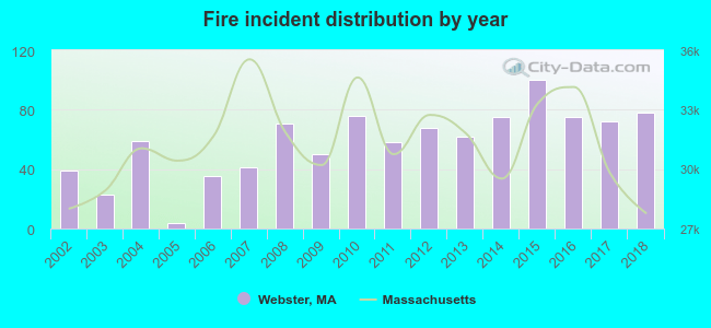
2002 - 2018 National Fire Incident Reporting System (NFIRS) incidents
Based on the data from the years 2002 - 2018 the average number of fires per year is 58. The highest number of reported fire incidents - 100 took place in 2015, and the least - 4 in 2005. The data has a rising trend.
When looking into fire subcategories, the most incidents belonged to: Structure Fires (50.2%), and Outside Fires (28.3%).
Fire incident types reported to NFIRS in Webster, MA


 Recent articles from our blog. Our writers, many of them Ph.D. graduates or candidates, create easy-to-read articles on a wide variety of topics.


 (15.6 miles


 Based on the data from the years 2002 - 2018 the average number of fires per year is 58. The highest number of reported fire incidents - 100 took place in 2015, and the least - 4 in 2005. The data has a rising trend.
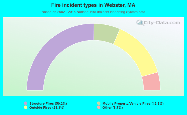 When looking into fire subcategories, the most incidents belonged to: Structure Fires (50.2%), and Outside Fires (28.3%).