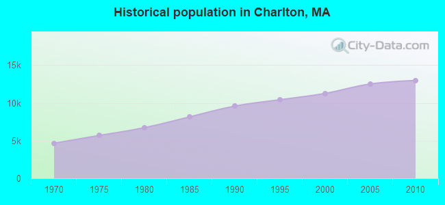
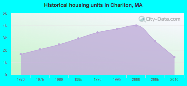
Charlton, Massachusetts
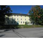
Charlton: The Historic Rider Tavern On Stafford Street

Charlton: The Historic Rider Tavern On Stafford Street
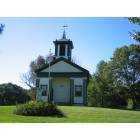
Charlton: The Historic one room School house on Northside Road
- add
your
Submit your own pictures of this town and show them to the world
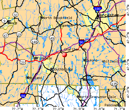
- OSM Map
- General Map
- Google Map
- MSN Map
Population change since 2000: +15.3%
 |
| Males: 6,378 | |
| Females: 6,603 |
| Median resident age: | 41.2 years |
| Massachusetts median age: | 39.2 years |
Zip codes: 01507.
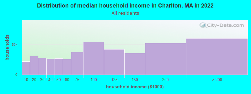
| Charlton: | $113,571 |
| MA: | $94,488 |
Estimated per capita income in 2022: $46,066 (it was $23,626 in 2000)
Charlton town income, earnings, and wages data
Estimated median house or condo value in 2022: $423,901 (it was $153,500 in 2000)
| Charlton: | $423,901 |
| MA: | $534,700 |
Mean prices in 2022: all housing units: $419,164; detached houses: $447,621; townhouses or other attached units: $343,592; in 2-unit structures: $323,295; in 3-to-4-unit structures: $332,295; in 5-or-more-unit structures: $232,758; mobile homes: $113,885
Detailed information about poverty and poor residents in Charlton, MA

Compare current foreclosures near Charlton, MA:
| Photo | Address | Area | Beds / Baths | Price | Details |
|---|---|---|---|---|---|

|
#1
Stafford St
Charlton, MA 01507
|
1,056 sq. feet
|
1 baths 3 beds |
show details | |

|
#2
Muggett Hill Rd
Charlton, MA 01507
|
2,728 sq. feet
|
2 baths 3 beds |
show details | |

|
#3
Lindsey Ln
Charlton, MA 01507
|
2,784 sq. feet
|
2 baths 4 beds |
show details | |

|
#4
Buffum Rd
Charlton, MA 01507
|
2,578 sq. feet
|
3 baths 4 beds |
show details | |

|
#5
Oak Ridge Dr
Charlton, MA 01507
|
1,531 sq. feet
|
1 baths 4 beds |
show details | |

|
#6
Lindsey Ln
Charlton, MA 01507
|
2,871 sq. feet
|
2 baths 4 beds |
show details | |

|
#7
Park Rd
Charlton, MA 01507
|
640 sq. feet
|
1 baths 2 beds |
show details | |

|
#8
Southbridge Rd Unit 104
Charlton, MA 01507
|
1,266 sq. feet
|
2 baths 2 beds |
show details | |

|
#9
Denfield Rd
Charlton, MA 01507
|
1,638 sq. feet
|
1 baths 3 beds |
show details | |

|
#10
Nugget Dr
Charlton, MA 01507
|
- sq. feet
|
- baths - beds |
show details |
| Photo | Address | Area | Beds / Baths | Price | Details |
|---|---|---|---|---|---|

|
#11
Sunset Dr
Charlton, MA 01507
|
- sq. feet
|
- baths - beds |
show details | |

|
#12
Stafford St Apt 46
Charlton, MA 01507
|
- sq. feet
|
- baths - beds |
show details | |

|
#13
J Davis Rd
Charlton, MA 01507
|
- sq. feet
|
- baths - beds |
show details | |

|
#14
Groton Pl
Worcester, MA 01604
|
1,768 sq. feet
|
2 baths 3 beds |
$420,000
|
show details |

|
#15
N Brookfield Rd
Oakham, MA 01068
|
1,078 sq. feet
|
1 baths 2 beds |
$409,900
|
show details |

|
#16
Clarence Dr
Oxford, MA 01540
|
3,010 sq. feet
|
3 baths 5 beds |
$549,900
|
show details |

|
#17
Illinois St
Worcester, MA 01603
|
3,116 sq. feet
|
3 baths 8 beds |
show details | |

|
#18
Merrifield St
Worcester, MA 01605
|
3,555 sq. feet
|
3 baths 9 beds |
show details | |

|
#19
Green Acres Ln
North Grosvenordale, CT 06255
|
1,040 sq. feet
|
1 baths 3 beds |
show details | |

|
#20
Lake Ave
Worcester, MA 01604
|
3,265 sq. feet
|
2 baths 3 beds |
show details |
| Photo | Address | Area | Beds / Baths | Price | Details |
|---|---|---|---|---|---|

|
#21
Union Rd
Wales, MA 01081
|
1,440 sq. feet
|
2 baths 3 beds |
show details | |

|
#22
Walker Rd
Thompson, CT 06277
|
2,324 sq. feet
|
3 baths 4 beds |
show details | |

|
#23
Treadwell Ter
Spencer, MA 01562
|
960 sq. feet
|
1 baths 3 beds |
show details | |

|
#24
Route 171
Woodstock Valley, CT 06282
|
1,075 sq. feet
|
4 baths 3 beds |
show details | |

|
#25
Martin Rd # 1
Douglas, MA 01516
|
1,250 sq. feet
|
1 baths 3 beds |
show details | |

|
#26
Red Cedar Rd
Woodstock Valley, CT 06282
|
1,102 sq. feet
|
2 baths 3 beds |
show details | |

|
#27
Van Den Noort St
Putnam, CT 06260
|
3,898 sq. feet
|
3 baths 8 beds |
show details | |

|
#28
Leo Cir
Quinebaug, CT 06262
|
1,040 sq. feet
|
1 baths 2 beds |
show details | |

|
#29
Hannah Dr
Whitinsville, MA 01588
|
2,563 sq. feet
|
3 baths 4 beds |
show details | |

|
#30
Lincoln St
Webster, MA 01570
|
1,505 sq. feet
|
2 baths 3 beds |
show details |
| Photo | Address | Area | Beds / Baths | Price | Details |
|---|---|---|---|---|---|

|
#31
Kendrick Ave
Worcester, MA 01606
|
1,384 sq. feet
|
2 baths 2 beds |
show details | |

|
#32
Cricklewood Dr
Leicester, MA 01524
|
1,989 sq. feet
|
2 baths 4 beds |
show details | |

|
#33
Maynard St
Putnam, CT 06260
|
1,510 sq. feet
|
2 baths 5 beds |
show details | |

|
#34
Redfield Rd
Cherry Valley, MA 01611
|
1,412 sq. feet
|
1 baths 3 beds |
show details | |

|
#35
Leicester St
Auburn, MA 01501
|
912 sq. feet
|
1 baths 2 beds |
show details | |

|
#36
-42 N Main St
Whitinsville, MA 01588
|
2,318 sq. feet
|
4 baths 6 beds |
show details | |

|
#37
Goldthwaite Rd
Whitinsville, MA 01588
|
1,930 sq. feet
|
1 baths 2 beds |
show details | |

|
#38
Sabin St Unit 1
Putnam, CT 06260
|
1,348 sq. feet
|
2 baths 2 beds |
show details | |

|
#39
Quaddick Rd
Thompson, CT 06277
|
2,051 sq. feet
|
2 baths 3 beds |
show details | |

|
#40
Marc Ave
Southbridge, MA 01550
|
960 sq. feet
|
1 baths 3 beds |
show details |
| Photo | Address | Area | Beds / Baths | Price | Details |
|---|---|---|---|---|---|

|
#41
Fabyan Rd
North Grosvenordale, CT 06255
|
1,203 sq. feet
|
1 baths 2 beds |
show details | |

|
#42
Wayne St
Worcester, MA 01603
|
1,260 sq. feet
|
2 baths 3 beds |
show details | |

|
#43
Old Douglas Rd
Webster, MA 01570
|
2,875 sq. feet
|
2 baths 3 beds |
show details | |

|
#44
Penn Ave
Worcester, MA 01604
|
2,406 sq. feet
|
2 baths 4 beds |
show details | |

|
#45
1/2 Putnam Hill Road
Sutton, MA 01590
|
1,415 sq. feet
|
1 baths 3 beds |
show details | |

|
#46
Sturbridge Rd
Brimfield, MA 01010
|
1,404 sq. feet
|
3 baths 2 beds |
show details | |

|
#47
Pine Tree Dr
Holland, MA 01521
|
1,800 sq. feet
|
3 baths 3 beds |
show details | |

|
#48
Elm Ct
Millbury, MA 01527
|
1,064 sq. feet
|
2 baths 3 beds |
show details | |

|
#49
Piedmont St
Worcester, MA 01609
|
4,071 sq. feet
|
3 baths 9 beds |
show details | |

|
Check over 1 million property listings on Foreclosure.com!
|
browse all offers | |||

- 12,23394.2%White alone
- 3742.9%Hispanic
- 1461.1%Two or more races
- 1140.9%Asian alone
- 750.6%Black alone
- 200.2%American Indian alone
- 110.08%Other race alone
- 80.06%Native Hawaiian and Other
Pacific Islander alone
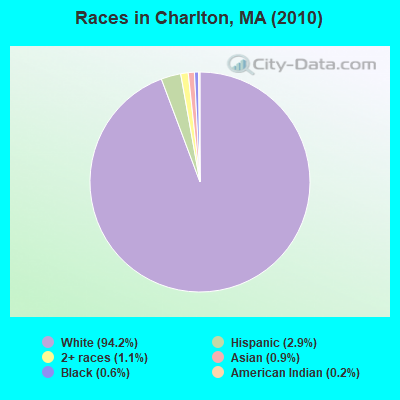
Races in Charlton detailed stats: ancestries, foreign born residents, place of birth
According to our research of Massachusetts and other state lists, there were 8 registered sex offenders living in Charlton, Massachusetts as of July 03, 2024.
The ratio of all residents to sex offenders in Charlton is 1,623 to 1.
The ratio of registered sex offenders to all residents in this city is near the state average.
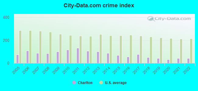
Type |
2009 |
2010 |
2011 |
2012 |
2013 |
2014 |
2015 |
2016 |
2017 |
2018 |
2019 |
2020 |
2021 |
2022 |
|---|---|---|---|---|---|---|---|---|---|---|---|---|---|---|
| Murders (per 100,000) | 0 (0.0) | 0 (0.0) | 0 (0.0) | 0 (0.0) | 0 (0.0) | 0 (0.0) | 0 (0.0) | 0 (0.0) | 0 (0.0) | 0 (0.0) | 0 (0.0) | 0 (0.0) | 1 (7.2) | 0 (0.0) |
| Rapes (per 100,000) | 2 (15.6) | 5 (38.5) | 3 (23.0) | 2 (15.2) | 5 (37.9) | 5 (37.7) | 3 (22.4) | 2 (14.9) | 4 (29.6) | 0 (0.0) | 2 (14.6) | 1 (7.3) | 1 (7.2) | 1 (7.5) |
| Robberies (per 100,000) | 3 (23.4) | 3 (23.1) | 2 (15.3) | 4 (30.4) | 2 (15.2) | 0 (0.0) | 1 (7.5) | 2 (14.9) | 2 (14.8) | 1 (7.3) | 0 (0.0) | 0 (0.0) | 0 (0.0) | 0 (0.0) |
| Assaults (per 100,000) | 10 (77.9) | 13 (100.1) | 14 (107.2) | 13 (98.9) | 16 (121.3) | 10 (75.4) | 3 (22.4) | 7 (52.1) | 13 (96.1) | 12 (87.9) | 6 (43.9) | 6 (43.7) | 6 (43.2) | 10 (74.7) |
| Burglaries (per 100,000) | 55 (428.5) | 48 (369.8) | 67 (513.0) | 47 (357.6) | 33 (250.1) | 40 (301.7) | 37 (276.2) | 12 (89.4) | 10 (73.9) | 11 (80.6) | 16 (117.0) | 12 (87.5) | 6 (43.2) | 10 (74.7) |
| Thefts (per 100,000) | 86 (670.0) | 88 (677.9) | 144 (1,103) | 117 (890.3) | 78 (591.1) | 51 (384.7) | 64 (477.8) | 63 (469.1) | 71 (525.0) | 71 (520.1) | 36 (263.2) | 24 (174.9) | 28 (201.7) | 36 (268.8) |
| Auto thefts (per 100,000) | 16 (124.7) | 9 (69.3) | 15 (114.9) | 8 (60.9) | 3 (22.7) | 9 (67.9) | 9 (67.2) | 5 (37.2) | 8 (59.2) | 8 (58.6) | 5 (36.6) | 8 (58.3) | 3 (21.6) | 11 (82.1) |
| Arson (per 100,000) | 0 (0.0) | 2 (15.4) | 1 (7.7) | 2 (15.2) | 1 (7.6) | 1 (7.5) | 0 (0.0) | 0 (0.0) | 1 (7.4) | 1 (7.3) | 1 (7.3) | 0 (0.0) | 0 (0.0) | 1 (7.5) |
| City-Data.com crime index | 101.8 | 116.3 | 133.6 | 106.6 | 102.1 | 87.2 | 68.5 | 54.8 | 78.2 | 50.9 | 42.1 | 32.4 | 41.6 | 43.5 |
The City-Data.com crime index weighs serious crimes and violent crimes more heavily. Higher means more crime, U.S. average is 246.1. It adjusts for the number of visitors and daily workers commuting into cities.
Crime rate in Charlton detailed stats: murders, rapes, robberies, assaults, burglaries, thefts, arson
Full-time law enforcement employees in 2021, including police officers: 27 (22 officers - 21 male; 1 female).
| Officers per 1,000 residents here: | 1.58 |
| Massachusetts average: | 2.53 |
 Recent articles from our blog. Our writers, many of them Ph.D. graduates or candidates, create easy-to-read articles on a wide variety of topics.

 | 2023 Real Estate Observations (5278 replies) |
| Report finds MA Roadways Dangerous (190 replies) |
| Coronavirus in Massachusetts (18060 replies) |
| Tree House Brewing Cape Cod (42 replies) |
| Charlton warn of men challenging others to rap battles (0 replies) |
| jobs and cheap apartments in Leominster or Worcester to move in September 2019 (17 replies) |
Latest news from Charlton, MA collected exclusively by city-data.com from local newspapers, TV, and radio stations
Ancestries: French (22.4%), Irish (19.4%), English (17.6%), Polish (11.1%), Italian (10.4%), French Canadian (7.2%).
Current Local Time: EST time zone
Incorporated in 1775
Elevation: 895 feet
Land area: 42.5 square miles.
Population density: 305 people per square mile (very low).
177 residents are foreign born
| This town: | 1.6% |
| Massachusetts: | 12.2% |
| Charlton town: | 1.1% ($1,661) |
| Massachusetts: | 1.3% ($2,336) |
Nearest city with pop. 50,000+: Worcester, MA  (12.6 miles , pop. 172,648).
Nearest city with pop. 200,000+: Boston, MA (46.9 miles , pop. 589,141).
Nearest city with pop. 1,000,000+: Bronx, NY (132.9 miles , pop. 1,332,650).
Nearest cities:
), ), Latitude: 42.14 N, Longitude: 71.97 W
Area codes: 508, 774

Charlton, Massachusetts accommodation & food services, waste management - Economy and Business Data
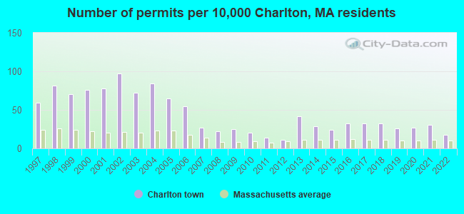
Single-family new house construction building permits:
- 2022: 20 buildings, average cost: $377,000
- 2021: 34 buildings, average cost: $262,400
- 2020: 30 buildings, average cost: $262,400
- 2019: 29 buildings, average cost: $262,400
- 2018: 36 buildings, average cost: $266,000
- 2017: 36 buildings, average cost: $267,800
- 2016: 37 buildings, average cost: $261,800
- 2015: 27 buildings, average cost: $257,200
- 2014: 32 buildings, average cost: $226,600
- 2013: 47 buildings, average cost: $194,900
- 2012: 13 buildings, average cost: $200,000
- 2011: 16 buildings, average cost: $199,800
- 2010: 23 buildings, average cost: $211,300
- 2009: 28 buildings, average cost: $198,600
- 2008: 25 buildings, average cost: $240,500
- 2007: 30 buildings, average cost: $192,700
- 2006: 62 buildings, average cost: $179,400
- 2005: 73 buildings, average cost: $166,500
- 2004: 95 buildings, average cost: $194,200
- 2003: 81 buildings, average cost: $172,900
- 2002: 110 buildings, average cost: $176,800
- 2001: 88 buildings, average cost: $118,300
- 2000: 85 buildings, average cost: $106,200
- 1999: 79 buildings, average cost: $105,300
- 1998: 92 buildings, average cost: $106,600
- 1997: 67 buildings, average cost: $122,800

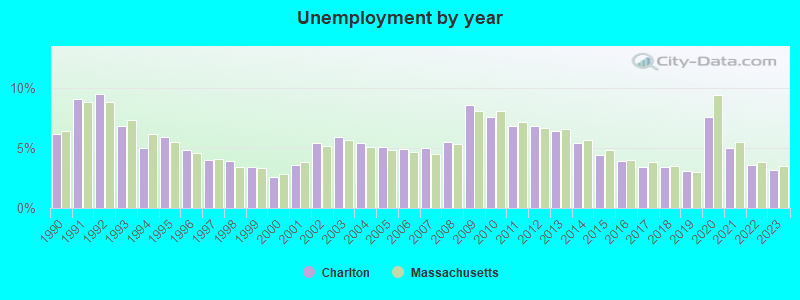
| Here: | 3.2% |
| Massachusetts: | 3.5% |
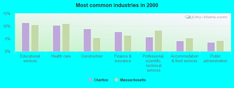
- Educational services (11.4%)
- Health care (10.4%)
- Construction (8.9%)
- Finance & insurance (7.8%)
- Professional, scientific, technical services (5.7%)
- Accommodation & food services (4.2%)
- Public administration (3.6%)
- Construction (15.2%)
- Educational services (7.3%)
- Professional, scientific, technical services (6.4%)
- Finance & insurance (6.1%)
- Metal & metal products (6.0%)
- Computer & electronic products (3.5%)
- Other transportation, support activities, couriers (3.2%)
- Health care (19.2%)
- Educational services (16.1%)
- Finance & insurance (9.8%)
- Accommodation & food services (6.0%)
- Professional, scientific, technical services (4.9%)
- Social assistance (4.7%)
- Public administration (4.2%)
- Other management occupations, except farmers and farm managers (4.9%)
- Preschool, kindergarten, elementary, and middle school teachers (4.9%)
- Computer specialists (4.4%)
- Other sales and related occupations, including supervisors (4.2%)
- Electrical equipment mechanics and other installation, maintenance, and repair workers, including supervisors (3.4%)
- Material recording, scheduling, dispatching, and distributing workers (3.4%)
- Other office and administrative support workers, including supervisors (3.3%)
- Computer specialists (7.1%)
- Other management occupations, except farmers and farm managers (6.4%)
- Electrical equipment mechanics and other installation, maintenance, and repair workers, including supervisors (5.9%)
- Other sales and related occupations, including supervisors (5.2%)
- Metal workers and plastic workers (4.7%)
- Operations specialties managers, except financial managers (4.3%)
- Carpenters (4.1%)
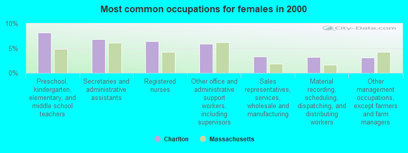
- Preschool, kindergarten, elementary, and middle school teachers (8.2%)
- Secretaries and administrative assistants (6.8%)
- Registered nurses (6.4%)
- Other office and administrative support workers, including supervisors (5.8%)
- Sales representatives, services, wholesale and manufacturing (3.3%)
- Material recording, scheduling, dispatching, and distributing workers (3.2%)
- Other management occupations, except farmers and farm managers (3.1%)
Average climate in Charlton, Massachusetts
Based on data reported by over 4,000 weather stations


(lower is better)

Air Quality Index (AQI) level in 2023 was 91.2. This is worse than average.
| City: | 91.2 |
| U.S.: | 72.6 |
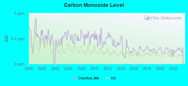
Carbon Monoxide (CO) [ppm] level in 2022 was 0.259. This is about average. Closest monitor was 12.2 miles away from the city center.
| City: | 0.259 |
| U.S.: | 0.251 |
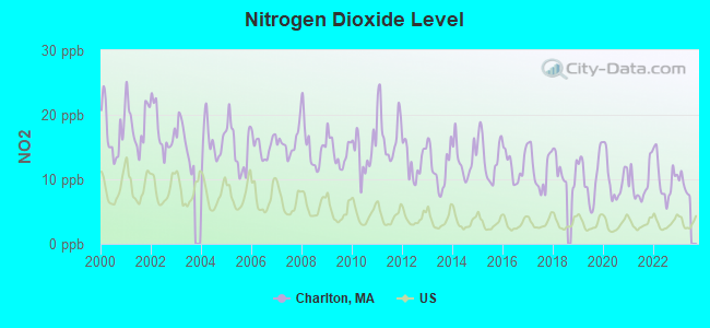
Nitrogen Dioxide (NO2) [ppb] level in 2022 was 10.1. This is significantly worse than average. Closest monitor was 10.9 miles away from the city center.
| City: | 10.1 |
| U.S.: | 5.1 |
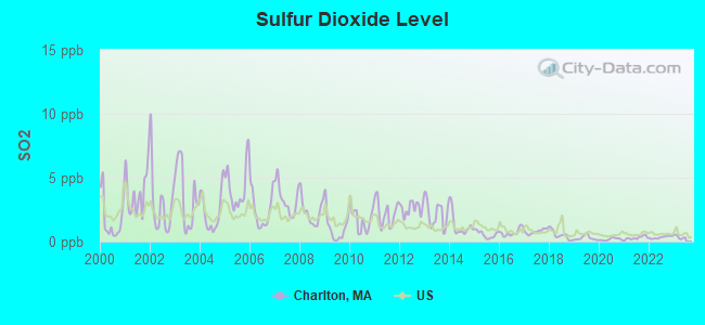
Sulfur Dioxide (SO2) [ppb] level in 2022 was 0.332. This is significantly better than average. Closest monitor was 10.9 miles away from the city center.
| City: | 0.332 |
| U.S.: | 1.515 |
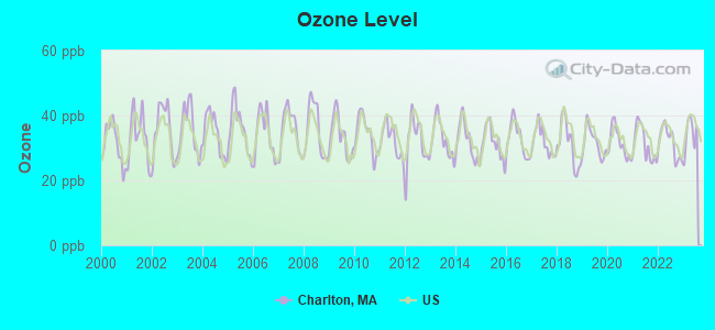
Ozone [ppb] level in 2023 was 34.1. This is about average. Closest monitor was 10.8 miles away from the city center.
| City: | 34.1 |
| U.S.: | 33.3 |
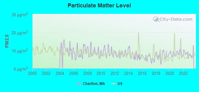
Particulate Matter (PM2.5) [µg/m3] level in 2022 was 8.16. This is about average. Closest monitor was 12.3 miles away from the city center.
| City: | 8.16 |
| U.S.: | 8.11 |
Tornado activity:
Charlton-area historical tornado activity is slightly above Massachusetts state average. It is 19% smaller than the overall U.S. average.
On 6/9/1953, a category F4 (max. wind speeds 207-260 mph) tornado 25.3 miles away from the Charlton town center killed 90 people and injured 1228 people and caused between $50,000,000 and $500,000,000 in damages.
On 6/9/1953, a category F3 (max. wind speeds 158-206 mph) tornado 10.5 miles away from the town center injured 17 people and caused between $500,000 and $5,000,000 in damages.
Earthquake activity:
Charlton-area historical earthquake activity is significantly above Massachusetts state average. It is 71% smaller than the overall U.S. average.On 10/7/1983 at 10:18:46, a magnitude 5.3 (5.1 MB, 5.3 LG, 5.1 ML, Class: Moderate, Intensity: VI - VII) earthquake occurred 173.7 miles away from Charlton center
On 4/20/2002 at 10:50:47, a magnitude 5.3 (5.3 ML, Depth: 3.0 mi) earthquake occurred 186.0 miles away from Charlton center
On 4/20/2002 at 10:50:47, a magnitude 5.2 (5.2 MB, 4.2 MS, 5.2 MW, 5.0 MW) earthquake occurred 184.9 miles away from Charlton center
On 1/19/1982 at 00:14:42, a magnitude 4.7 (4.5 MB, 4.7 MD, 4.5 LG, Class: Light, Intensity: IV - V) earthquake occurred 96.2 miles away from Charlton center
On 10/16/2012 at 23:12:25, a magnitude 4.7 (4.7 ML, Depth: 10.0 mi) earthquake occurred 121.1 miles away from Charlton center
On 8/22/1992 at 12:20:32, a magnitude 4.8 (4.8 MB, 3.8 MS, 4.7 LG, Depth: 6.2 mi) earthquake occurred 226.7 miles away from the city center
Magnitude types: regional Lg-wave magnitude (LG), body-wave magnitude (MB), duration magnitude (MD), local magnitude (ML), surface-wave magnitude (MS), moment magnitude (MW)
Natural disasters:
The number of natural disasters in Worcester County (27) is a lot greater than the US average (15).Major Disasters (Presidential) Declared: 15
Emergencies Declared: 12
Causes of natural disasters: Floods: 9, Storms: 8, Hurricanes: 6, Snowstorms: 5, Winter Storms: 4, Blizzards: 2, Snows: 2, Fire: 1, Heavy Rain: 1, Snowfall: 1, Tornado: 1, Wind: 1 (Note: some incidents may be assigned to more than one category).
Hospitals and medical centers in Charlton:
- OVERLOOK VNA AND HOSPICE SERVICES (88 MASONIC HOME ROAD, PO BOX 1000)
- OVERLOOK MASONIC HEALTH CENTER (MASONIC HOME ROAD PO BOX 1000)
Other hospitals and medical centers near Charlton:
- SANDALWOOD CARE AND REHABILITATION CENTER (Nursing Home, about 6 miles away; OXFORD, MA)
- LIBERTY HOUSE (Nursing Home, about 6 miles away; SOUTHBRIDGE, MA)
- PROVIDENCE HOUSE N H OF SOUTHBRIDGE (Nursing Home, about 6 miles away; SOUTHBRIDGE, MA)
- RADIUS HEALTHCARE-SOUTHBRIDGE (Nursing Home, about 6 miles away; SOUTHBRIDGE, MA)
- HARRINGTON MEMORIAL HOSPITAL Acute Care Hospitals (about 6 miles away; SOUTHBRIDGE, MA)
- KINDRED TRANSITIONAL CARE AND REHAB-THE MEADOWS (Nursing Home, about 7 miles away; ROCHDALE, MA)
- LIFE CARE CENTER OF AUBURN (Nursing Home, about 7 miles away; AUBURN, MA)
Airports located in Charlton:
- Dresser Hill Airport (MA30) (Runways: 1)
Amtrak station near Charlton:
College/University in Charlton:
Colleges/universities with over 2000 students nearest to Charlton:
- College of the Holy Cross (about 11 miles; Worcester, MA; Full-time enrollment: 3,125)
- Clark University (about 11 miles; Worcester, MA; FT enrollment: 3,687)
- Worcester State University (about 12 miles; Worcester, MA; FT enrollment: 5,426)
- Worcester Polytechnic Institute (about 13 miles; Worcester, MA; FT enrollment: 3,930)
- Assumption College (about 14 miles; Worcester, MA; FT enrollment: 2,580)
- Quinsigamond Community College (about 16 miles; Worcester, MA; FT enrollment: 5,877)
- Bryant University (about 27 miles; Smithfield, RI; FT enrollment: 3,440)
Public high school in Charlton:
Public elementary/middle schools in Charlton:
- CHARLTON MIDDLE SCHOOL (Students: 801, Location: 2 OXFORD ROAD, Grades: 5-8)
- HERITAGE SCHOOL (Students: 570, Location: 34 OXFORD RD, Grades: 2-4)
- CHARLTON ELEMENTARY (Students: 433, Location: 9 BURLINGAME ROAD, Grades: PK-1)
Points of interest:
Notable locations in Charlton: Wood Lot Campground (A), Charlton Orchard (B), Fay Mountain Farm (C), Camp Joslin (D), Camp Bement (E), Heritage Country Club (F), Charlton Fire Department (G). Display/hide their locations on the map
Churches in Charlton include: Charlton Federated Church (A), Charlton Baptist Church (B). Display/hide their locations on the map
Cemeteries: Dresser Cemetery (1), Bay Path Cemetery (2), Westridge Cemetery (3), Union Cemetery (4), Northside Cemetery (5). Display/hide their locations on the map
Lakes and reservoirs: Tucker Pond (A), Snows Pond (B), Hultered Pond (C), Hammond Pond (D), Dodge Pond (E), Ashworth Pond (F), McIntyre Pond (G), Blood Pond (H). Display/hide their locations on the map
Streams, rivers, and creeks: South Fork Little River (A), Pratt Brook (B). Display/hide their locations on the map
Park in Charlton: Northside Village Historic District (1). Display/hide its location on the map
Tourist attractions: Charlton Historical Society (Museums; Stafford) (1), Capen Hill Nature Sanctuary (Museums; 56 Capen Road) (2). Display/hide their approximate locations on the map
Hotel: Redwood Motel (Worcester Rd) (1). Display/hide its approximate location on the map
Birthplace of: William T. G. Morton - Physician, Linus B. Comins - Politician.
Drinking water stations with addresses in Charlton and their reported violations in the past:
RMZ, LLC; DBA SHAKERZ (Serves RI, Population served: 100, Groundwater):Past monitoring violations:
- One routine major monitoring violation
Drinking water stations with addresses in Charlton that have no violations reported:
- OVERLOOK LIFE CARE COMMUNITY (Population served: 857, Primary Water Source Type: Groundwater)
- BOW MUNICIPAL WATER SYSTEM (Serves NH, Population served: 25, Primary Water Source Type: Groundwater)
| This town: | 2.8 people |
| Massachusetts: | 2.5 people |
| This town: | 77.1% |
| Whole state: | 63.0% |
| This town: | 7.5% |
| Whole state: | 7.0% |
Likely homosexual households (counted as self-reported same-sex unmarried-partner households)
- Lesbian couples: 0.7% of all households
- Gay men: 0.4% of all households
| This town: | 5.6% |
| Whole state: | 9.3% |
| This town: | 2.8% |
| Whole state: | 4.4% |
4 people in other noninstitutional facilities in 2010
People in group quarters in Charlton in 2000:
- 180 people in nursing homes
- 15 people in other nonhousehold living situations
- 2 people in homes for the mentally retarded
Banks with branches in Charlton (2011 data):
- Country Bank for Savings: Overlook Life Care Community Branch at 88 Masonic Home Road, branch established on 2006/06/12; Charlton Branch at 37 Worcester Road, branch established on 2004/04/23. Info updated 2006/09/29: Bank assets: $1,431.1 mil, Deposits: $953.8 mil, headquarters in Ware, MA, positive income, Mortgage Lending Specialization, 15 total offices
- Savers Co-operative Bank: Charlton Branch at 90 Worcester Road, branch established on 1987/10/01. Info updated 2011/08/19: Bank assets: $414.6 mil, Deposits: $307.9 mil, headquarters in Southbridge, MA, positive income, Mortgage Lending Specialization, 6 total offices
- Southbridge Savings Bank: Charlton Branch at 63 Main Street, branch established on 1976/02/23. Info updated 2008/10/14: Bank assets: $419.3 mil, Deposits: $329.4 mil, headquarters in Southbridge, MA, positive income, Commercial Lending Specialization, 9 total offices, Holding Company: Green Valley Bancorp, Mhc
For population 15 years and over in Charlton:
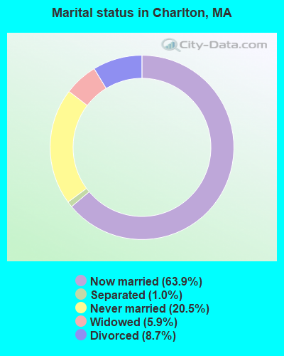
- Never married: 20.5%
- Now married: 63.9%
- Separated: 1.0%
- Widowed: 5.9%
- Divorced: 8.7%
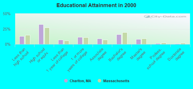
For population 25 years and over in Charlton:
- High school or higher: 86.8%
- Bachelor's degree or higher: 26.4%
- Graduate or professional degree: 10.5%
- Unemployed: 2.2%
- Mean travel time to work (commute): 28.3 minutes
| Here: | 10.9 |
| Massachusetts average: | 13.1 |


Graphs represent county-level data. Detailed 2008 Election Results
Religion statistics for Charlton, MA (based on Worcester County data)


| Religion | Adherents | Congregations |
|---|---|---|
| Catholic | 306,925 | 118 |
| Mainline Protestant | 43,326 | 171 |
| Evangelical Protestant | 37,511 | 203 |
| Other | 18,931 | 69 |
| Orthodox | 7,935 | 15 |
| Black Protestant | 497 | 6 |
| None | 383,427 | - |
Food Environment Statistics:
| This county: | 1.73 / 10,000 pop. |
| Massachusetts: | 1.98 / 10,000 pop. |
| Worcester County: | 0.05 / 10,000 pop. |
| Massachusetts: | 0.05 / 10,000 pop. |
| Worcester County: | 1.79 / 10,000 pop. |
| Massachusetts: | 2.22 / 10,000 pop. |
| Worcester County: | 2.22 / 10,000 pop. |
| Massachusetts: | 1.77 / 10,000 pop. |
| Here: | 7.27 / 10,000 pop. |
| Massachusetts: | 8.76 / 10,000 pop. |
| Worcester County: | 8.0% |
| Massachusetts: | 8.1% |
| This county: | 24.0% |
| State: | 22.5% |
| Worcester County: | 16.6% |
| Massachusetts: | 16.5% |
4.71% of this county's 2021 resident taxpayers lived in other counties in 2020 ($76,229 average adjusted gross income)
| Here: | 4.71% |
| Massachusetts average: | 6.35% |
0.02% of residents moved from foreign countries ($100 average AGI)
Worcester County: 0.02% Massachusetts average: 0.01%
Top counties from which taxpayers relocated into this county between 2020 and 2021:
| from Middlesex County, MA | |
| from Norfolk County, MA | |
| from Suffolk County, MA |
4.84% of this county's 2020 resident taxpayers moved to other counties in 2021 ($87,252 average adjusted gross income)
| Here: | 4.84% |
| Massachusetts average: | 7.18% |
0.03% of residents moved to foreign countries ($199 average AGI)
Worcester County: 0.03% Massachusetts average: 0.02%
Top counties to which taxpayers relocated from this county between 2020 and 2021:
| to Middlesex County, MA | |
| to Norfolk County, MA | |
| to Suffolk County, MA |
| Businesses in Charlton, MA | ||||
| Name | Count | Name | Count | |
|---|---|---|---|---|
| CVS | 1 | MasterBrand Cabinets | 1 | |
| Dunkin Donuts | 1 | McDonald's | 2 | |
| FedEx | 1 | U-Haul | 1 | |
| Jones New York | 1 | |||
Strongest AM radio stations in Charlton:
- WCRN (830 AM; 50 kW; WORCESTER, MA; Owner: CARTER BROADCASTING CORPORATION)
- WVNE (760 AM; daytime; 25 kW; LEICESTER, MA; Owner: BLOUNT MASSCOM, INC.)
- WALE (990 AM; 50 kW; GREENVILLE, RI; Owner: NORTH AMERICAN BROADCASTING CO., INC.)
- WKOX (1200 AM; 50 kW; FRAMINGHAM, MA; Owner: CAPSTAR TX LIMITED PARTNERSHIP)
- WNNZ (640 AM; 50 kW; WESTFIELD, MA; Owner: CLEAR CHANNEL BROADCASTING LICENSES, INC.)
- WBIX (1060 AM; 40 kW; NATICK, MA; Owner: LANGER BROADCASTING CORPORATION)
- WESO (970 AM; 1 kW; SOUTHBRIDGE, MA)
- WEEI (850 AM; 50 kW; BOSTON, MA; Owner: ENTERCOM BOSTON LICENSE, LLC)
- WORC (1310 AM; 5 kW; WORCESTER, MA; Owner: CHOWDER BROADCAST GROUP LLC)
- WRKO (680 AM; 50 kW; BOSTON, MA; Owner: ENTERCOM BOSTON LICENSE, LLC)
- WAMG (890 AM; 25 kW; DEDHAM, MA; Owner: MEGA COMMUNICATIONS OF DEDHAM LICENSEE, LLC)
- WTAG (580 AM; 5 kW; WORCESTER, MA; Owner: CAPSTAR TX LIMITED PARTNERSHIP)
- WVEI (1440 AM; 5 kW; WORCESTER, MA; Owner: ENTERCOM BOSTON LICENSE, LLC)
Strongest FM radio stations in Charlton:
- WYCM (90.1 FM; CHARLTON, MA; Owner: BAY PATH VOCATIONAL HIGH SCHOOL)
- WAAF (107.3 FM; WORCESTER, MA; Owner: ENTERCOM BOSTON LICENSE, LLC)
- WWFX (100.1 FM; SOUTHBRIDGE, MA; Owner: CITADEL BROADCASTING COMPANY)
- WORC-FM (98.9 FM; WEBSTER, MA; Owner: CITADEL BROADCASTING COMPANY)
- WSRS (96.1 FM; WORCESTER, MA; Owner: CAPSTAR TX LIMITED PARTNERSHIP)
- WBPR (91.9 FM; WORCESTER, MA; Owner: UNIVERSITY OF MASSACHUSETTS)
- WFCR (88.5 FM; AMHERST, MA; Owner: UNIVERSITY OF MASSACHUSETTS)
- WICN (90.5 FM; WORCESTER, MA; Owner: WICN PUBLIC RADIO, INC)
- WBMX (98.5 FM; BOSTON, MA; Owner: INFINITY RADIO OPERATIONS INC.)
- WHYN-FM (93.1 FM; SPRINGFIELD, MA; Owner: CLEAR CHANNEL BROADCASTING LICENSES, INC.)
- WJMN (94.5 FM; BOSTON, MA; Owner: AMFM RADIO LICENSES, L.L.C.)
- WXLO (104.5 FM; FITCHBURG, MA; Owner: CITADEL BROADCASTING COMPANY)
- WCRB (102.5 FM; WALTHAM, MA; Owner: CHARLES RIVER BROADCASTING WCRB LICE)
- WTKK (96.9 FM; BOSTON, MA; Owner: GREATER BOSTON RADIO, INC.)
- WAMH (89.3 FM; AMHERST, MA; Owner: TRUSTEES OF AMHERST COLLEGE)
- WROR-FM (105.7 FM; FRAMINGHAM, MA; Owner: GREATER BOSTON RADIO, INC.)
- WBOS (92.9 FM; BROOKLINE, MA; Owner: GREATER BOSTON RADIO, INC.)
- WGBH (89.7 FM; BOSTON, MA; Owner: WGBH EDUCATIONAL FOUNDATION)
- WRNX (100.9 FM; AMHERST, MA; Owner: WESTERN MASSACHUSETTS RADIO COMPANY)
- WFEX (92.1 FM; PETERBOROUGH, NH; Owner: FNX BROADCASTING OF NEW HAMPSHIRE LLC)
TV broadcast stations around Charlton:
- WYDN (Channel 48; WORCESTER, MA; Owner: EDUCATIONAL PUBLIC TV CORPORATION)
- WUNI (Channel 27; WORCESTER, MA; Owner: ENTRAVISION HOLDINGS, LLC)
- WCRN-LP (Channel 34; LEICESTER, MA; Owner: CARTER BROADCASTING CORPORATION)
- WUTF (Channel 66; MARLBOROUGH, MA; Owner: TELEFUTURA BOSTON LLC)
- WCVB-TV (Channel 5; BOSTON, MA; Owner: WCVB HEARST-ARGYLE TV, INC.)
- WGBH-TV (Channel 2; BOSTON, MA; Owner: WGBH EDUCATIONAL FOUNDATION)
- WPXQ (Channel 69; BLOCK ISLAND, RI; Owner: OCEAN STATE TELEVISION, L.L.C.)
- WHDH-TV (Channel 7; BOSTON, MA; Owner: WHDH-TV)
- WMFP (Channel 62; LAWRENCE, MA; Owner: WSAH LICENSE, INC.)
- WBZ-TV (Channel 4; BOSTON, MA; Owner: VIACOM INC.)
- WGBX-TV (Channel 44; BOSTON, MA; Owner: WGBH EDUCATIONAL FOUNDATION)
- WSBK-TV (Channel 38; BOSTON, MA; Owner: VIACOM INC.)
- WLVI-TV (Channel 56; CAMBRIDGE, MA; Owner: WLVI, INC.)
- WFXT (Channel 25; BOSTON, MA; Owner: FOX TELEVISION STATIONS INC.)
- WTIC-TV (Channel 61; HARTFORD, CT; Owner: TRIBUNE TELEVISION COMPANY)
- WNAC-TV (Channel 64; PROVIDENCE, RI; Owner: WNAC, LLC)
- WPRI-TV (Channel 12; PROVIDENCE, RI; Owner: TVL BROADCASTING OF RHODE ISLAND, LLC)
- WLNE-TV (Channel 6; NEW BEDFORD, MA; Owner: FREEDOM BROADCASTING OF SOUTHERN NEW ENGLAND, INC.)
- WJAR (Channel 10; PROVIDENCE, RI; Owner: OUTLET BROADCASTING, INC.)
- W40BO (Channel 40; BOSTON, MA; Owner: PAXSON COMMUNICATIONS LPTV, INC.)
- National Bridge Inventory (NBI) Statistics
- 34Number of bridges
- 230ft / 69.5mTotal length
- $48,118,000Total costs
- 562,591Total average daily traffic
- 39,028Total average daily truck traffic
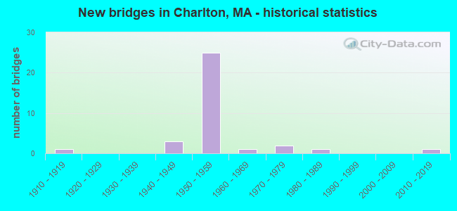
- New bridges - historical statistics
- 11910-1919
- 31940-1949
- 251950-1959
- 11960-1969
- 21970-1979
- 11980-1989
- 12010-2019
FCC Registered Commercial Land Mobile Towers: 2 (See the full list of FCC Registered Commercial Land Mobile Towers in Charlton, MA)
FCC Registered Private Land Mobile Towers: 1 (See the full list of FCC Registered Private Land Mobile Towers)
FCC Registered Broadcast Land Mobile Towers: 22 (See the full list of FCC Registered Broadcast Land Mobile Towers)
FCC Registered Microwave Towers: 9 (See the full list of FCC Registered Microwave Towers in this town)
FCC Registered Amateur Radio Licenses: 66 (See the full list of FCC Registered Amateur Radio Licenses in Charlton)
FAA Registered Aircraft: 9 (See the full list of FAA Registered Aircraft in Charlton)
2002 - 2018 National Fire Incident Reporting System (NFIRS) incidents
- Fire incident types reported to NFIRS in Charlton, MA
- 67156.9%Structure Fires
- 28023.7%Outside Fires
- 21718.4%Mobile Property/Vehicle Fires
- 110.9%Other
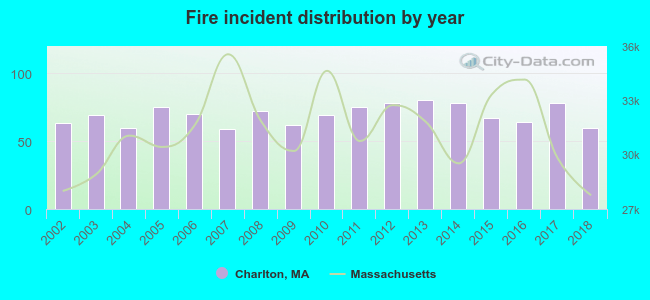 Based on the data from the years 2002 - 2018 the average number of fires per year is 69. The highest number of reported fires - 80 took place in 2013, and the least - 59 in 2007. The data has a decreasing trend.
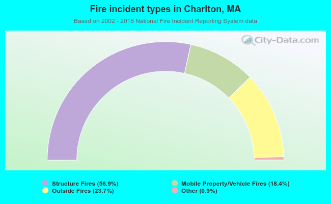 When looking into fire subcategories, the most incidents belonged to: Structure Fires (56.9%), and Outside Fires (23.7%).
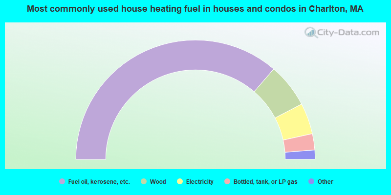
- 72.7%Fuel oil, kerosene, etc.
- 12.0%Wood
- 8.4%Electricity
- 4.4%Bottled, tank, or LP gas
- 1.0%Coal or coke
- 0.9%Utility gas
- 0.5%Other fuel
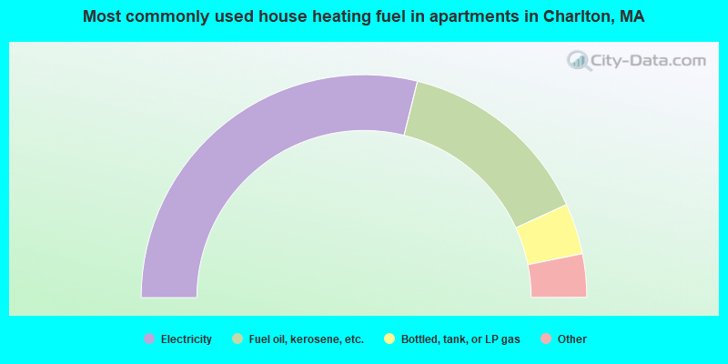
- 57.8%Electricity
- 28.6%Fuel oil, kerosene, etc.
- 7.4%Bottled, tank, or LP gas
- 3.2%Utility gas
- 1.5%Wood
- 1.5%Other fuel
Charlton compared to Massachusetts state average:
- Unemployed percentage significantly below state average.
- Black race population percentage significantly below state average.
- Hispanic race population percentage significantly below state average.
- Foreign-born population percentage significantly below state average.
- Renting percentage below state average.
- Length of stay since moving in significantly above state average.
- Number of rooms per house significantly below state average.
- House age significantly below state average.
Charlton on our top lists:
- #11 on the list of "Top 101 cities with largest percentage of males in occupations: operations specialties managers except financial managers (population 5,000+)"
- #19 on the list of "Top 101 cities with largest percentage of females in occupations: other health diagnosing and treating practitioners and technical occupations (population 5,000+)"
- #27 on the list of "Top 101 cities with largest percentage of females in occupations: communications equipment operators (population 5,000+)"
- #49 on the list of "Top 101 cities with largest percentage of males in occupations: supervisors of construction and extraction workers (population 5,000+)"
- #51 on the list of "Top 101 cities with largest percentage of males in industries: nonmetallic mineral products (population 5,000+)"
- #70 on the list of "Top 101 cities with largest percentage of females in industries: paper (population 5,000+)"
- #70 on the list of "Top 101 cities with largest percentage of females in industries: u. s. postal service (population 5,000+)"
- #76 on the list of "Top 101 cities with largest percentage of males in occupations: computer specialists (population 5,000+)"
- #78 on the list of "Top 101 cities with largest percentage of females in industries: miscellaneous manufacturing (population 5,000+)"
- #90 (01507) on the list of "Top 101 zip codes with the largest percentage of Lithuanian first ancestries (pop 5,000+)"
- #4 on the list of "Top 101 counties with the highest carbon monoxide air pollution readings in 2012 (ppm)"
- #5 on the list of "Top 101 counties with the most Catholic congregations"
- #12 on the list of "Top 101 counties with the highest surface withdrawal of fresh water for public supply"
- #16 on the list of "Top 101 counties with the highest total withdrawal of fresh water for public supply"
- #23 on the list of "Top 101 counties with the highest Sulfur Oxides Annual air pollution readings in 2012 (µg/m3)"

|
|
Total of 192 patent applications in 2008-2024.