Washington, Connecticut
Submit your own pictures of this town and show them to the world
- OSM Map
- General Map
- Google Map
- MSN Map
Population change since 2000: -0.5%
 |
| Males: 1,773 | |
| Females: 1,805 |
| Median resident age: | 49.7 years |
| Connecticut median age: | 39.2 years |
Zip codes: 06794.
| Washington: | $107,043 |
| CT: | $88,429 |
Estimated per capita income in 2022: $66,731 (it was $37,215 in 2000)
Washington town income, earnings, and wages data
Estimated median house or condo value in 2022: $579,387 (it was $268,000 in 2000)
| Washington: | $579,387 |
| CT: | $347,200 |
Mean prices in 2022: all housing units: $429,743; detached houses: $455,293; townhouses or other attached units: $232,674; in 2-unit structures: $242,050; in 3-to-4-unit structures: $229,634; in 5-or-more-unit structures: $182,162; mobile homes: $243,504; occupied boats, rvs, vans, etc.: $127,144
Detailed information about poverty and poor residents in Washington, CT
Compare current foreclosures near Washington, CT:
| Photo | Address | Area | Beds / Baths | Price | Details |
|---|---|---|---|---|---|

|
#1
Wieting Rd
New Milford, CT 06776
|
3,210 sq. feet
|
3 baths 5 beds |
$549,900
|
show details |

|
#2
Meadow Brook Rd
Brookfield, CT 06804
|
2,261 sq. feet
|
2 baths 4 beds |
$520,000
|
show details |

|
#3
Clinton Hill Rd
Wolcott, CT 06716
|
1,828 sq. feet
|
1 baths 3 beds |
$240,000
|
show details |

|
#4
Woodbine St
Torrington, CT 06790
|
2,756 sq. feet
|
3 baths 6 beds |
$419,900
|
show details |

|
#5
Janwood Rd
Waterbury, CT 06708
|
1,200 sq. feet
|
2 baths 3 beds |
$275,000
|
show details |

|
#6
Elmira Ave
Torrington, CT 06790
|
1,242 sq. feet
|
2 baths 3 beds |
show details | |

|
#7
Chestnut Ridge Rd
Dover Plains, NY 12522
|
1,002 sq. feet
|
1 baths 2 beds |
show details | |

|
#8
Alder St
Waterbury, CT 06708
|
1,310 sq. feet
|
1 baths 2 beds |
show details | |

|
#9
Marcia Dr
Torrington, CT 06790
|
1,496 sq. feet
|
2 baths 4 beds |
show details | |

|
#10
Beach St
Litchfield, CT 06759
|
2,624 sq. feet
|
2 baths 4 beds |
show details |
| Photo | Address | Area | Beds / Baths | Price | Details |
|---|---|---|---|---|---|

|
#11
Doran St
Waterbury, CT 06704
|
1,036 sq. feet
|
1 baths 3 beds |
show details | |

|
#12
Litchfield Rd
Harwinton, CT 06791
|
2,216 sq. feet
|
1 baths 3 beds |
show details | |

|
#13
Whitewood Rd
Waterbury, CT 06708
|
1,132 sq. feet
|
2 baths 3 beds |
show details | |

|
#14
Ridge Rd
Dover Plains, NY 12522
|
1,120 sq. feet
|
2 baths 4 beds |
show details | |

|
#15
Deerwood Ln Unit 4
Waterbury, CT 06704
|
972 sq. feet
|
1 baths 2 beds |
show details | |

|
#16
Walnut St
Terryville, CT 06786
|
1,080 sq. feet
|
1 baths 3 beds |
show details | |

|
#17
Fairfield Ave
Waterbury, CT 06708
|
1,152 sq. feet
|
1 baths 3 beds |
show details | |

|
#18
Crestwood Rd
Torrington, CT 06790
|
2,380 sq. feet
|
2 baths 4 beds |
show details | |

|
#19
N Main St
Waterbury, CT 06704
|
912 sq. feet
|
1 baths 3 beds |
show details | |

|
#20
Park Ln W
New Milford, CT 06776
|
1,278 sq. feet
|
1 baths 3 beds |
show details |
| Photo | Address | Area | Beds / Baths | Price | Details |
|---|---|---|---|---|---|

|
#21
Blackman Rd
Waterbury, CT 06704
|
1,280 sq. feet
|
1 baths 3 beds |
show details | |

|
#22
Cooke St
Waterbury, CT 06710
|
1,545 sq. feet
|
2 baths 3 beds |
show details | |

|
#23
Hill St Apt 19
Waterbury, CT 06704
|
613 sq. feet
|
1 baths 1 beds |
show details | |

|
#24
N Beacon St
Waterbury, CT 06704
|
1,603 sq. feet
|
2 baths 3 beds |
show details | |

|
#25
N Main St
Waterbury, CT 06704
|
1,300 sq. feet
|
1 baths 3 beds |
show details | |

|
#26
Yale Ave
Torrington, CT 06790
|
1,196 sq. feet
|
1 baths 2 beds |
show details | |

|
#27
Preston Rd
Terryville, CT 06786
|
1,165 sq. feet
|
1 baths 3 beds |
show details | |

|
#28
Circle Dr
Torrington, CT 06790
|
1,226 sq. feet
|
2 baths 3 beds |
show details | |

|
#29
Route 22
Wassaic, NY 12592
|
1,904 sq. feet
|
2 baths 4 beds |
show details | |

|
#30
Washington Ct
Pawling, NY 12564
|
2,396 sq. feet
|
2 baths 3 beds |
show details |
| Photo | Address | Area | Beds / Baths | Price | Details |
|---|---|---|---|---|---|

|
#31
Holt St Apt 70
Terryville, CT 06786
|
1,064 sq. feet
|
1 baths 2 beds |
show details | |

|
#32
Sleepy Hollow Rd
New Fairfield, CT 06812
|
1,868 sq. feet
|
3 baths 3 beds |
show details | |

|
#33
Second Hill Rd
New Milford, CT 06776
|
3,662 sq. feet
|
2 baths 4 beds |
show details | |

|
#34
Delaware Ave
Waterbury, CT 06708
|
1,450 sq. feet
|
1 baths 2 beds |
show details | |

|
#35
Tower Rd
Middlebury, CT 06762
|
2,608 sq. feet
|
2 baths 4 beds |
show details | |

|
#36
Pearl St
Torrington, CT 06790
|
1,344 sq. feet
|
1 baths 2 beds |
show details | |

|
#37
Willow St
Torrington, CT 06790
|
2,076 sq. feet
|
2 baths 5 beds |
show details | |

|
#38
Joy Rd
Waterbury, CT 06708
|
1,650 sq. feet
|
1 baths 4 beds |
show details | |

|
#39
Taryn Ln
New Milford, CT 06776
|
1,086 sq. feet
|
1 baths 3 beds |
show details | |

|
#40
Ridge Rd
Terryville, CT 06786
|
3,157 sq. feet
|
3 baths 5 beds |
show details |
| Photo | Address | Area | Beds / Baths | Price | Details |
|---|---|---|---|---|---|

|
#41
Jeremy Swamp Rd
Southbury, CT 06488
|
3,592 sq. feet
|
3 baths 5 beds |
show details | |

|
#42
Berkshire Rd
Southbury, CT 06488
|
1,655 sq. feet
|
1 baths 2 beds |
show details | |

|
#43
W Whisconier Rd
Brookfield, CT 06804
|
3,075 sq. feet
|
2 baths 4 beds |
show details | |

|
#44
Fern Cir
Waterbury, CT 06708
|
2,280 sq. feet
|
2 baths 3 beds |
show details | |

|
#45
Bioski Rd
Middlebury, CT 06762
|
1,512 sq. feet
|
2 baths 3 beds |
show details | |

|
#46
Mcguinness St
Torrington, CT 06790
|
1,049 sq. feet
|
1 baths 3 beds |
show details | |

|
#47
Candlewood Lake Rd
Brookfield, CT 06804
|
2,656 sq. feet
|
2 baths 6 beds |
show details | |

|
#48
N Harwinton Ave
Terryville, CT 06786
|
2,046 sq. feet
|
3 baths 3 beds |
show details | |

|
#49
Fieldwood Rd
Waterbury, CT 06704
|
1,236 sq. feet
|
2 baths 5 beds |
show details | |

|
Check over 1 million property listings on Foreclosure.com!
|
browse all offers | |||

- 3,34593.5%White alone
- 1424.0%Hispanic
- 371.0%Two or more races
- 260.7%Asian alone
- 200.6%Black alone
- 50.1%Other race alone
- 30.08%American Indian alone

Races in Washington detailed stats: ancestries, foreign born residents, place of birth
 Recent articles from our blog. Our writers, many of them Ph.D. graduates or candidates, create easy-to-read articles on a wide variety of topics.


 | 2024 Connecticut Town Tournament VI (Celebrating the 10-Year Anniversary & Dazzleman's Memorial) (830 replies) |
| Connecticut Weather Discussion 3 (8061 replies) |
| Connecticut TOWN TOURNAMENT V (2022) (831 replies) |
| Top 100 Most Expensive Towns and Villages in the U.S. (30 replies) |
| COVID-19 in Connecticut (7486 replies) |
| Travel Writer--CT Lacks Grit (24 replies) |
Latest news from Washington, CT collected exclusively by city-data.com from local newspapers, TV, and radio stations
Washington, CT City Guides:
Ancestries: English (22.9%), Irish (19.1%), German (14.5%), Italian (10.8%), United States (6.7%), Polish (5.0%).
Current Local Time: EST time zone
Incorporated on 01/1779
Elevation: 693 feet
Land area: 38.2 square miles.
Population density: 94 people per square mile (very low).

285 residents are foreign born (3.5% Europe, 1.9% Asia, 0.9% Latin America).
| This town: | 7.9% |
| Connecticut: | 10.9% |
| Washington town: | 1.1% ($2,856) |
| Connecticut: | 1.8% ($2,961) |
Nearest city with pop. 50,000+: Waterbury, CT  (16.0 miles , pop. 107,271).
Nearest city with pop. 200,000+: Bronx, NY (62.8 miles , pop. 1,332,650).
Nearest cities:
), ), ), Latitude: 41.65 N, Longitude: 73.32 W
Area code: 860


Single-family new house construction building permits:
- 2022: 16 buildings, average cost: $788,500
- 2021: 3 buildings, average cost: $1,750,000
- 2020: 7 buildings, average cost: $970,500
- 2019: 6 buildings, average cost: $432,200
- 2018: 7 buildings, average cost: $1,082,000
- 2017: 4 buildings, average cost: $620,000
- 2016: 4 buildings, average cost: $268,900
- 2015: 6 buildings, average cost: $389,300
- 2014: 8 buildings, average cost: $625,900
- 2013: 5 buildings, average cost: $691,800
- 2012: 3 buildings, average cost: $267,000
- 2011: 4 buildings, average cost: $1,340,800
- 2010: 4 buildings, average cost: $2,640,100
- 2009: 4 buildings, average cost: $1,022,100
- 2008: 4 buildings, average cost: $310,000
- 2007: 6 buildings, average cost: $643,800
- 2006: 15 buildings, average cost: $417,600
- 2005: 18 buildings, average cost: $417,600
- 2004: 10 buildings, average cost: $216,700
- 2003: 7 buildings, average cost: $216,700
- 2002: 8 buildings, average cost: $216,700
- 2001: 8 buildings, average cost: $216,700
- 2000: 10 buildings, average cost: $216,700
- 1999: 12 buildings, average cost: $216,700
- 1998: 13 buildings, average cost: $216,800
- 1997: 14 buildings, average cost: $216,600


| Here: | 2.2% |
| Connecticut: | 3.9% |


- Educational services (13.7%)
- Construction (9.4%)
- Health care (9.3%)
- Professional, scientific, technical services (7.8%)
- Finance & insurance (5.1%)
- Food & beverage stores (4.7%)
- Accommodation & food services (4.4%)

- Construction (17.1%)
- Educational services (11.2%)
- Professional, scientific, technical services (8.2%)
- Finance & insurance (4.8%)
- Food & beverage stores (4.5%)
- Agriculture, forestry, fishing & hunting (4.2%)
- Administrative & support & waste management services (3.5%)

- Health care (17.0%)
- Educational services (16.6%)
- Professional, scientific, technical services (7.4%)
- Accommodation & food services (5.7%)
- Finance & insurance (5.3%)
- Food & beverage stores (4.9%)
- Administrative & support & waste management services (4.8%)

- Other management occupations, except farmers and farm managers (5.7%)
- Other sales and related occupations, including supervisors (5.0%)
- Building and grounds cleaning and maintenance occupations (4.4%)
- Sales representatives, services, wholesale and manufacturing (4.2%)
- Retail sales workers, except cashiers (4.1%)
- Information and record clerks, except customer service representatives (4.1%)
- Preschool, kindergarten, elementary, and middle school teachers (3.4%)

- Construction traders workers except carpenters, electricians, painters, plumbers, and construction laborers (6.0%)
- Other management occupations, except farmers and farm managers (5.8%)
- Building and grounds cleaning and maintenance occupations (5.3%)
- Sales representatives, services, wholesale and manufacturing (5.3%)
- Retail sales workers, except cashiers (5.1%)
- Carpenters (4.4%)
- Lawyers (3.9%)

- Other sales and related occupations, including supervisors (6.6%)
- Registered nurses (6.5%)
- Information and record clerks, except customer service representatives (5.9%)
- Other management occupations, except farmers and farm managers (5.7%)
- Secretaries and administrative assistants (5.7%)
- Preschool, kindergarten, elementary, and middle school teachers (4.3%)
- Other office and administrative support workers, including supervisors (4.0%)
Average climate in Washington, Connecticut
Based on data reported by over 4,000 weather stations


(lower is better)

Air Quality Index (AQI) level in 2023 was 92.8. This is worse than average.
| City: | 92.8 |
| U.S.: | 72.6 |

Carbon Monoxide (CO) [ppm] level in 2022 was 0.149. This is significantly better than average. Closest monitor was 11.7 miles away from the city center.
| City: | 0.149 |
| U.S.: | 0.251 |

Nitrogen Dioxide (NO2) [ppb] level in 2015 was 2.27. This is significantly better than average. Closest monitor was 5.0 miles away from the city center.
| City: | 2.27 |
| U.S.: | 5.11 |

Sulfur Dioxide (SO2) [ppb] level in 2022 was 0.109. This is significantly better than average. Closest monitor was 5.0 miles away from the city center.
| City: | 0.109 |
| U.S.: | 1.515 |

Ozone [ppb] level in 2023 was 33.4. This is about average. Closest monitor was 9.2 miles away from the city center.
| City: | 33.4 |
| U.S.: | 33.3 |

Particulate Matter (PM10) [µg/m3] level in 2022 was 13.1. This is significantly better than average. Closest monitor was 11.7 miles away from the city center.
| City: | 13.1 |
| U.S.: | 19.2 |

Particulate Matter (PM2.5) [µg/m3] level in 2022 was 6.18. This is better than average. Closest monitor was 11.7 miles away from the city center.
| City: | 6.18 |
| U.S.: | 8.11 |
Tornado activity:
Washington-area historical tornado activity is slightly above Connecticut state average. It is 22% smaller than the overall U.S. average.
On 7/10/1989, a category F4 (max. wind speeds 207-260 mph) tornado 28.8 miles away from the Washington town center injured 40 people and caused between $50,000,000 and $500,000,000 in damages.
On 5/24/1962, a category F3 (max. wind speeds 158-206 mph) tornado 12.5 miles away from the town center killed one person and injured 50 people and caused between $500,000 and $5,000,000 in damages.
Earthquake activity:
Washington-area historical earthquake activity is significantly above Connecticut state average. It is 69% smaller than the overall U.S. average.On 10/7/1983 at 10:18:46, a magnitude 5.3 (5.1 MB, 5.3 LG, 5.1 ML, Class: Moderate, Intensity: VI - VII) earthquake occurred 167.3 miles away from the city center
On 4/20/2002 at 10:50:47, a magnitude 5.3 (5.3 ML, Depth: 3.0 mi) earthquake occurred 198.7 miles away from Washington center
On 4/20/2002 at 10:50:47, a magnitude 5.2 (5.2 MB, 4.2 MS, 5.2 MW, 5.0 MW) earthquake occurred 197.0 miles away from the city center
On 8/23/2011 at 17:51:04, a magnitude 5.8 (5.8 MW, Depth: 3.7 mi) earthquake occurred 356.7 miles away from Washington center
On 1/19/1982 at 00:14:42, a magnitude 4.7 (4.5 MB, 4.7 MD, 4.5 LG, Class: Light, Intensity: IV - V) earthquake occurred 154.8 miles away from Washington center
On 1/16/1994 at 01:49:16, a magnitude 4.6 (4.6 MB, 4.6 LG, Depth: 3.1 mi) earthquake occurred 168.9 miles away from Washington center
Magnitude types: regional Lg-wave magnitude (LG), body-wave magnitude (MB), duration magnitude (MD), local magnitude (ML), surface-wave magnitude (MS), moment magnitude (MW)
Natural disasters:
The number of natural disasters in Litchfield County (23) is greater than the US average (15).Major Disasters (Presidential) Declared: 13
Emergencies Declared: 10
Causes of natural disasters: Storms: 7, Hurricanes: 5, Floods: 4, Snowstorms: 4, Blizzards: 3, Snows: 2, Tropical Storms: 2, Winter Storms: 2, Snowfall: 1, Tornado: 1, Wind: 1 (Note: some incidents may be assigned to more than one category).

Hospitals and medical centers near Washington:
- CANDLEWOOD VALLEY HEALTH AND R (Nursing Home, about 6 miles away; NEW MILFORD, CT)
- NEW MILFORD VNA INC (Home Health Center, about 6 miles away; NEW MILFORD, CT)
- VILLAGE CREST CENTER FOR HEALTH AND REHABILITATION (Nursing Home, about 7 miles away; NEW MILFORD, CT)
- NEW MILFORD HOSPITAL Acute Care Hospitals (about 7 miles away; NEW MILFORD, CT)
- ABILITY BEYOND DISABILITY LANE (Hospital, about 10 miles away; NEW MILFORD, CT)
- KENT, LTD, THE (Nursing Home, about 10 miles away; KENT, CT)
- ROSE HAVEN, LTD (Nursing Home, about 10 miles away; LITCHFIELD, CT)
Airports located in Washington:
- Cambrown Airport (CT66) (Runways: 1)
Colleges/universities with over 2000 students nearest to Washington:
- Naugatuck Valley Community College (about 15 miles; Waterbury, CT; Full-time enrollment: 4,491)
- Post University (about 15 miles; Waterbury, CT; FT enrollment: 5,808)
- University of Connecticut-Tri-Campus (about 16 miles; Waterbury, CT; FT enrollment: 2,250)
- Western Connecticut State University (about 19 miles; Danbury, CT; FT enrollment: 5,345)
- Tunxis Community College (about 24 miles; Farmington, CT; FT enrollment: 2,787)
- Quinnipiac University (about 28 miles; Hamden, CT; FT enrollment: 8,153)
- Central Connecticut State University (about 29 miles; New Britain, CT; FT enrollment: 9,989)
Public high school in Washington:
- SHEPAUG VALLEY SCHOOL (Students: 331, Location: 159 SOUTH STREET, Grades: 6-12)
Private high school in Washington:
Public elementary/middle school in Washington:
User-submitted facts and corrections:
- Additional large private School in Washington, Connecticut is Rumsey-Hall, Romford Road. 302 Students, K-9.
Points of interest:
Notable locations in Washington: Washington Depot (A), Lake Wanamaug Country Club (B), The Clam Shell (C), Preston Hill (D), Washington Golf Course (E), Institute for American Indian Studies Research and Education Library (F), Gunn Memorial Museum (G), Gunn Memorial Library (H), Washington Ambulance Association (I), New Preston Fire Department (J), Washington Fire Marshal's Office (K), Washington Volunteer Fire Department (L). Display/hide their locations on the map
Churches in Washington include: New Church (A), New Preston Congregational Church (B). Display/hide their locations on the map
Cemeteries: Romford Cemetery (1), Judea Cemetery (2). Display/hide their locations on the map
Lakes, reservoirs, and swamps: Lake Waramaug (A), Quist Pond (B), Wyant Pond (C), Ash Swamp (D), Poplar Swamp (E), Meeker Swamp (F). Display/hide their locations on the map
Streams, rivers, and creeks: Mallory Brook (A), Bantam River (B), Bee Brook (C), Kirby Brook (D). Display/hide their locations on the map
Parks in Washington include: Mount Bushnell State Park (1), Mount Tom State Park (2), Bryan Plaza (3), New Preston Hill Historic District (4). Display/hide their locations on the map
Tourist attraction: Institute for American Indian (Museums; Curtis Road) (1). Display/hide its approximate location on the map
Hotel: Mayflower Inn (118 Woodbury Road) (1). Display/hide its approximate location on the map
Birthplace of: Benjamin Foulois - First military aviator, John Wheeler Leavitt - Railroad executive, Orville H. Platt - Politician, Elisha Mitchell - Educator.
Drinking water stations with addresses in Washington and their reported violations in the past:
RUMSEY HALL SCHOOL (Population served: 398, Groundwater):Past health violations:GUNNERY SCHOOL (Population served: 280, Groundwater):Past monitoring violations:
- MCL, Monthly (TCR) - In MAY-2005, Contaminant: Coliform. Follow-up actions: St Violation/Reminder Notice (JUN-02-2005), St Public Notif requested (JUN-02-2005), St Public Notif received (JUL-14-2005), St Compliance achieved (DEC-31-2005)
- MCL, Monthly (TCR) - In APR-2005, Contaminant: Coliform. Follow-up actions: St Violation/Reminder Notice (MAY-09-2005), St Public Notif requested (MAY-09-2005), St Public Notif received (MAY-19-2005), St Compliance achieved (DEC-31-2005)
- Initial Tap Sampling for Pb and Cu - In JUL-01-2005, Contaminant: Lead and Copper Rule. Follow-up actions: St Violation/Reminder Notice (OCT-19-2005), St Public Notif requested (OCT-19-2005), St Public Notif received (OCT-28-2005), St Compliance achieved (DEC-31-2005)
- 3 regular monitoring violations
Past monitoring violations:
- Follow-up Or Routine LCR Tap M/R - In OCT-01-2013, Contaminant: Lead and Copper Rule. Follow-up actions: St Violation/Reminder Notice (MAR-06-2014), St Compliance achieved (MAR-06-2014)
- Monitoring and Reporting (DBP) - Between JUL-2013 and SEP-2013, Contaminant: Chlorine. Follow-up actions: St Violation/Reminder Notice (MAR-06-2014), St Compliance achieved (MAR-06-2014)
| This town: | 2.3 people |
| Connecticut: | 2.5 people |
| This town: | 64.4% |
| Whole state: | 66.3% |
| This town: | 5.6% |
| Whole state: | 6.6% |
Likely homosexual households (counted as self-reported same-sex unmarried-partner households)
- Lesbian couples: 0.4% of all households
- Gay men: 1.3% of all households
| This town: | 3.3% |
| Whole state: | 7.9% |
| This town: | 1.2% |
| Whole state: | 3.9% |
People in group quarters in Washington in 2010:
- 121 people in workers' group living quarters and job corps centers
- 18 people in residential schools for people with disabilities
- 13 people in college/university student housing
People in group quarters in Washington in 2000:
- 100 people in residential treatment centers for emotionally disturbed children
- 52 people in college dormitories (includes college quarters off campus)
- 17 people in other noninstitutional group quarters
For population 15 years and over in Washington:

- Never married: 26.8%
- Now married: 56.3%
- Separated: 0.7%
- Widowed: 7.4%
- Divorced: 8.9%
For population 25 years and over in Washington:
- High school or higher: 90.9%
- Bachelor's degree or higher: 41.5%
- Graduate or professional degree: 19.7%
- Unemployed: 7.7%
- Mean travel time to work (commute): 28.8 minutes


| Here: | 10.7 |
| Connecticut average: | 12.8 |
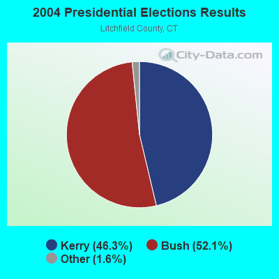
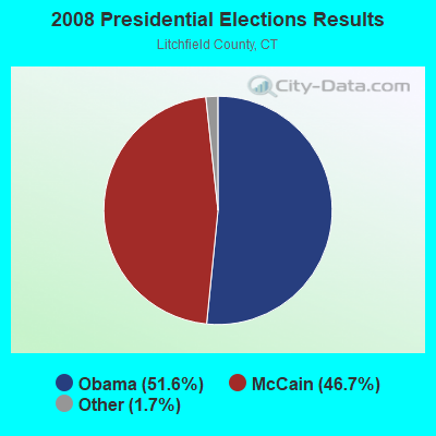
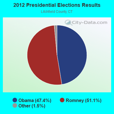
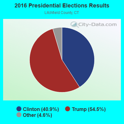
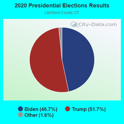
Graphs represent county-level data. Detailed 2008 Election Results
Religion statistics for Washington, CT (based on Litchfield County data)
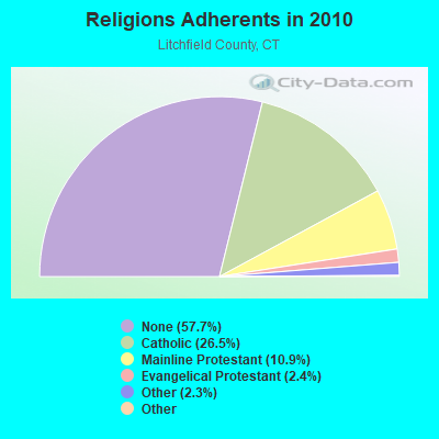
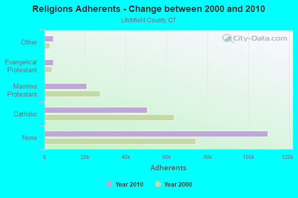
| Religion | Adherents | Congregations |
|---|---|---|
| Catholic | 50,354 | 30 |
| Mainline Protestant | 20,681 | 87 |
| Evangelical Protestant | 4,483 | 39 |
| Other | 4,420 | 16 |
| Orthodox | 175 | 2 |
| Black Protestant | 160 | 2 |
| None | 109,654 | - |
Food Environment Statistics:
| Litchfield County: | 2.29 / 10,000 pop. |
| State: | 2.21 / 10,000 pop. |
| Litchfield County: | 0.05 / 10,000 pop. |
| Connecticut: | 0.07 / 10,000 pop. |
| Litchfield County: | 0.64 / 10,000 pop. |
| Connecticut: | 1.02 / 10,000 pop. |
| This county: | 2.98 / 10,000 pop. |
| Connecticut: | 2.27 / 10,000 pop. |
| Litchfield County: | 11.07 / 10,000 pop. |
| Connecticut: | 9.19 / 10,000 pop. |
| Litchfield County: | 6.9% |
| Connecticut: | 7.3% |
| Litchfield County: | 21.1% |
| Connecticut: | 21.5% |
| Litchfield County: | 11.8% |
| Connecticut: | 15.8% |
Strongest AM radio stations in Washington:
- WTIC (1080 AM; 50 kW; HARTFORD, CT; Owner: INFINITY RADIO OPERATIONS INC.)
- WNNZ (640 AM; 50 kW; WESTFIELD, MA; Owner: CLEAR CHANNEL BROADCASTING LICENSES, INC.)
- WFAN (660 AM; 50 kW; NEW YORK, NY; Owner: INFINITY BROADCASTING OPERATIONS, INC.)
- WCBS (880 AM; 50 kW; NEW YORK, NY; Owner: INFINITY BROADCASTING OPERATIONS, INC.)
- WMCA (570 AM; 50 kW; NEW YORK, NY; Owner: SALEM MEDIA OF NEW YORK, LLC)
- WABC (770 AM; 50 kW; NEW YORK, NY; Owner: WABC-AM RADIO, INC.)
- WATR (1320 AM; 5 kW; WATERBURY, CT; Owner: WATR, INC.)
- WOR (710 AM; 50 kW; NEW YORK, NY; Owner: BUCKLEY BROADCASTING CORPORATION)
- WFNW (1380 AM; 5 kW; NAUGATUCK, CT; Owner: CANDIDO DIAS CARRELO)
- WGSM (740 AM; 25 kW; HUNTINGTON, NY; Owner: K RADIO LICENSEE, INC.)
- WEPN (1050 AM; 50 kW; NEW YORK, NY; Owner: NEW YORK AM RADIO, LLC)
- WINS (1010 AM; 50 kW; NEW YORK, NY; Owner: INFINITY BROADCASTING OPERATIONS, INC.)
- WBBR (1130 AM; 50 kW; NEW YORK, NY; Owner: BLOOMBERG COMMUNICATIONS INC.)
Strongest FM radio stations in Washington:
- W218AV (91.5 FM; WARREN, CT; Owner: MONROE BOARD OF EDUCATION)
- W206AW (89.1 FM; PAWLING, NY; Owner: SOUND OF LIFE, INC.)
- WRKI (95.1 FM; BROOKFIELD, CT; Owner: CUMULUS LICENSING CORP.)
- WRCH (100.5 FM; NEW BRITAIN, CT; Owner: INFINITY RADIO OPERATIONS INC.)
- WQQQ (103.3 FM; SHARON, CT; Owner: THE RIDGEFIELD BROADCASTING CORPORATION)
- WKCI-FM (101.3 FM; HAMDEN, CT; Owner: CLEAR CHANNEL BROADCASTING LICENSES, INC.)
- WRNQ (92.1 FM; POUGHKEEPSIE, NY; Owner: CLEAR CHANNEL BROADCASTING LICENSES, INC.)
- WPDH (101.5 FM; POUGHKEEPSIE, NY; Owner: CUMULUS LICENSING CORP.)
- WPLR (99.1 FM; NEW HAVEN, CT; Owner: COX RADIO, INC.)
- WJMJ (88.9 FM; HARTFORD, CT; Owner: ST. THOMAS SEMINARY)
- WDBY (105.5 FM; PATTERSON, NY; Owner: CUMULUS LICENSING CORP.)
- WWYZ (92.5 FM; WATERBURY, CT; Owner: CAPSTAR TX LIMITED PARTNERSHIP)
- WKSS (95.7 FM; HARTFORD-MERIDEN, CT; Owner: CAPSTAR TX LIMITED PARTNERSHIP)
- WZMX (93.7 FM; HARTFORD, CT; Owner: INFINITY RADIO OPERATIONS INC.)
- WHCN (105.9 FM; HARTFORD, CT; Owner: CAPSTAR TX LIMITED PARTNERSHIP)
- WMRQ (104.1 FM; WATERBURY, CT; Owner: CAPSTAR TX LIMITED PARTNERSHIP)
- WSPK (104.7 FM; POUGHKEEPSIE, NY; Owner: 6 JOHNSON ROAD LICENSES, INC.)
- WFNP (88.7 FM; ROSENDALE, NY; Owner: STATE UNIVERSITY OF NEW YORK)
- WRHV (88.7 FM; POUGHKEEPSIE, NY; Owner: WMHT EDUCATIONAL TELECOMMUNICATIONS)
- WPKT (90.5 FM; MERIDEN, CT; Owner: CONNECTICUT PUBLIC BROADCASTING, INC)
TV broadcast stations around Washington:
- WTIC-TV (Channel 61; HARTFORD, CT; Owner: TRIBUNE TELEVISION COMPANY)
- W11BJ (Channel 11; HARTFORD, CT; Owner: COMMUNICATIONS SITE MANAGEMENT LLC)
- WTXX (Channel 20; WATERBURY, CT; Owner: WTXX INC.)
- WVIT (Channel 30; NEW BRITAIN, CT; Owner: OUTLET BROADCASTING, INC)
- WEDH (Channel 24; HARTFORD, CT; Owner: CONNECTICUT PUBLIC BROADCASTING, INC.)
- WUVN (Channel 18; HARTFORD, CT; Owner: ENTRAVISION HOLDINGS, LLC)
- WTNH (Channel 8; NEW HAVEN, CT; Owner: WTNH BROADCASTING, INC.)
- WCTX (Channel 59; NEW HAVEN, CT; Owner: WTNH BROADCASTING, INC.)
- WEDY (Channel 65; NEW HAVEN, CT; Owner: CONNECTICUT PUBLIC BROADCASTING, INC.)
- WFSB (Channel 3; HARTFORD, CT; Owner: MEREDITH CORPORATION)
- WTBY (Channel 54; POUGHKEEPSIE, NY; Owner: TRINITY BROADCASTING OF NEW YORK, INC.)
- WEDW (Channel 49; BRIDGEPORT, CT; Owner: CONNECTICUT PUBLIC BROADCASTING, INC.)
- W12BH (Channel 12; WATERBURY, CT; Owner: CONN.PUBLIC BROADCASTING, INC.)
- WSAH (Channel 43; BRIDGEPORT, CT; Owner: WSAH LICENSE, INC.)

- National Bridge Inventory (NBI) Statistics
- 26Number of bridges
- 157ft / 48.2mTotal length
- $9,285,000Total costs
- 326,209Total average daily traffic
- 35,279Total average daily truck traffic
- 484,715Total future (year 2035) average daily traffic

- New bridges - historical statistics
- 11910-1919
- 11920-1929
- 31930-1939
- 141950-1959
- 21980-1989
- 21990-1999
- 12000-2009
- 22010-2019
FCC Registered Broadcast Land Mobile Towers:
4- PW, Blackville Rd (Lat: 41.646528 Lon: -73.316056), Type: Mtower, Structure height: 28.3 m, Call Sign: KXX561,
Assigned Frequencies: 158.775 MHz, Grant Date: 01/27/2024, Expiration Date: 03/28/2034, Registrant: Northeastern Communications, Inc., 7 Great Hill Road, Naugatuck, CT 06770, Phone: (203) 575-9008, Email:
- WASHINGTON, 10-12 Blackville Road (Lat: 41.646528 Lon: -73.316056), Type: Gtower, Structure height: 43.5 m, Call Sign: WQLB415,
Assigned Frequencies: 155.107 MHz, 155.122 MHz, Grant Date: 12/20/2019, Expiration Date: 11/20/2029, Certifier: Joseph Delbuono, Registrant: Northeastern Communications Inc., 7 Great Hill Rd, Naugatuck, CT 06770, Phone: (203) 575-9008, Email:
- Lat: 41.630389 Lon: -73.306389, Call Sign: WRBQ665,
Assigned Frequencies: 451.737 MHz, 452.687 MHz, 456.187 MHz, 456.737 MHz, 457.687 MHz, Grant Date: 05/22/2018, Expiration Date: 05/22/2028, Certifier: John Sorbara, Registrant: Northeastern Communications, Inc., 7 Great Hill Road, Naugatuck, CT 06770, Phone: (203) 575-9008, Email:
- Lat: 41.646389 Lon: -73.303333, Call Sign: WSAI938,
Assigned Frequencies: 452.412 MHz, 452.987 MHz, 457.312 MHz, 457.412 MHz, 457.987 MHz, Grant Date: 01/20/2024, Expiration Date: 01/20/2034, Certifier: Scott Swanson, Registrant: Houston Communications, 1105 Industrial Blvd., Sugar Land, TX 77478, Phone: (281) 491-1616, Email:
FCC Registered Amateur Radio Licenses:
3- Call Sign: N2BIE, Grant Date: 03/15/1994, Expiration Date: 03/15/2004, Cancellation Date: 03/16/2006, Registrant: Xavier March, 12 Painted Ridge Rd, Washington, CT 06793
- Call Sign: WA1PJY, Licensee ID: L00983809, Grant Date: 05/03/2016, Expiration Date: 06/12/2026, Registrant: John M Wyshynski, 74 Hinkle Rd, Washington, CT 06793
- Call Sign: KC1RNN, Licensee ID: L02574985, Grant Date: 06/30/2022, Expiration Date: 06/30/2032, Certifier: Silvio Libanio, Registrant: Silvio Libanio, 229 Woodbury Rd, Washington, CT 06793
FAA Registered Aircraft:
2- Aircraft: CONSOLIDATED VULTEE BT-13A (Category: Land, Seats: 2, Weight: Up to 12,499 Pounds, Speed: 108 mph), Engine: P&W R-985 SERIES (450 HP) (Reciprocating)
N-Number: 52622, N52622, N-52622, Serial Number: 418, Year manufactured: 1940
Registrant (Individual): Douglas R Bouton, Nettleton Hollow Rd, Washington, CT 06793
Deregistered: Cancel Date: 10/28/2017 - Aircraft: MAULE MX-7-235 (Category: Land, Seats: 5, Weight: Up to 12,499 Pounds), Engine: LYCOMING IO-540 SER (300 HP) (Reciprocating)
N-Number: 819MJ, N819MJ, N-819MJ, Serial Number: 10015-C, Year manufactured: 1985, Airworthiness Date: 03/22/1994, Certificate Issue Date: 12/14/1993
Registrant (Individual): Walter L Iii Johnson, 20 W Mountain Rd, Washington, CT 06793
Deregistered: Cancel Date: 02/27/2017, Exported to: Uruguay

- 82.7%Fuel oil, kerosene, etc.
- 7.1%Electricity
- 5.0%Wood
- 3.4%Bottled, tank, or LP gas
- 0.7%Coal or coke
- 0.6%Other fuel
- 0.4%Utility gas

- 76.4%Fuel oil, kerosene, etc.
- 9.8%Electricity
- 9.2%Bottled, tank, or LP gas
- 4.6%Wood
Washington compared to Connecticut state average:
- Median house value above state average.
- Unemployed percentage below state average.
- Black race population percentage significantly below state average.
- Hispanic race population percentage significantly below state average.
- Median age significantly above state average.
- Foreign-born population percentage below state average.
- Length of stay since moving in significantly above state average.
- Number of rooms per house significantly below state average.
- House age significantly below state average.
Washington on our top lists:
- #6 on the list of "Top 101 cities with the largest percentage of people in residential treatment centers for emotionally disturbed children (population 1,000+)"
- #7 on the list of "Top 101 counties with the lowest Particulate Matter (PM10) Annual air pollution readings in 2012 (µg/m3)"
- #10 on the list of "Top 101 counties with the lowest number of births per 1000 residents 2007-2013"
- #21 on the list of "Top 101 counties with the largest decrease in the number of births per 1000 residents 2000-2006 to 2007-2013 (pop 50,000+)"
- #38 on the list of "Top 101 counties with the lowest Particulate Matter (PM2.5) Annual air pollution readings in 2012 (µg/m3)"
- #39 on the list of "Top 101 counties with the highest carbon monoxide air pollution readings in 2012 (ppm)"

|
Total of 13 patent applications in 2008-2024.