Roxbury, Connecticut
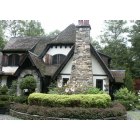
Submit your own pictures of this town and show them to the world
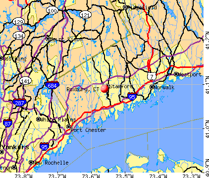
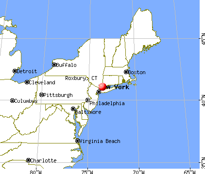
- OSM Map
- General Map
- Google Map
- MSN Map
Population change since 2000: +5.9%
 |
| Males: 1,137 | |
| Females: 1,125 |
| Median resident age: | 50.0 years |
| Connecticut median age: | 39.2 years |
Zip codes: 06783.
| Roxbury: | $143,942 |
| CT: | $88,429 |
Estimated per capita income in 2022: $101,794 (it was $56,769 in 2000)
Roxbury town income, earnings, and wages data
Estimated median house or condo value in 2022: $822,816 (it was $380,600 in 2000)
| Roxbury: | $822,816 |
| CT: | $347,200 |
Mean prices in 2022: all housing units: $429,743; detached houses: $455,293; townhouses or other attached units: $232,674; in 2-unit structures: $242,050; in 3-to-4-unit structures: $229,634; in 5-or-more-unit structures: $182,162; mobile homes: $243,504; occupied boats, rvs, vans, etc.: $127,144
Detailed information about poverty and poor residents in Roxbury, CT


- 2,15095.0%White alone
- 482.1%Hispanic
- 271.2%Two or more races
- 180.8%Asian alone
- 130.6%Black alone
- 30.1%American Indian alone
- 30.1%Other race alone
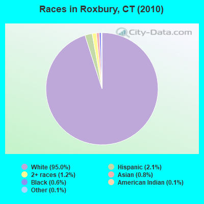
Races in Roxbury detailed stats: ancestries, foreign born residents, place of birth
 Recent articles from our blog. Our writers, many of them Ph.D. graduates or candidates, create easy-to-read articles on a wide variety of topics.


Latest news from Roxbury, CT collected exclusively by city-data.com from local newspapers, TV, and radio stations
Ancestries: English (25.0%), Irish (18.0%), German (13.3%), Italian (9.7%), Polish (6.7%), Scottish (6.5%).
Current Local Time: EST time zone
Incorporated on 10/1796
Land area: 26.2 square miles.
Population density: 86 people per square mile (very low).
93 residents are foreign born (2.0% Europe, 1.3% Asia).
| This town: | 4.4% |
| Connecticut: | 10.9% |
| Roxbury town: | 0.9% ($3,435) |
| Connecticut: | 1.8% ($2,961) |
Nearest city with pop. 50,000+: Danbury, CT  (13.3 miles , pop. 74,848).
Nearest city with pop. 200,000+: North Hempstead, NY (57.1 miles , pop. 222,611).
Nearest city with pop. 1,000,000+: Bronx, NY (57.3 miles , pop. 1,332,650).
Nearest cities:
), ), ), ), )Latitude: 41.56 N, Longitude: 73.31 W


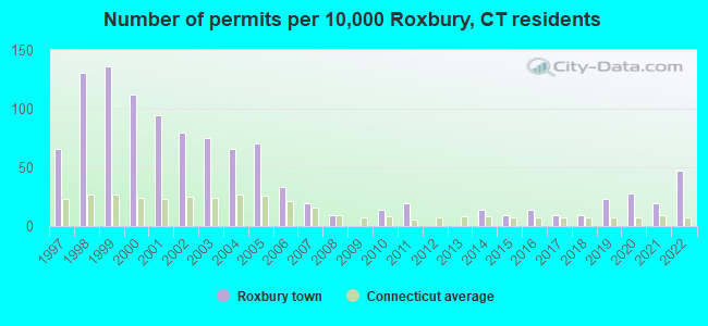
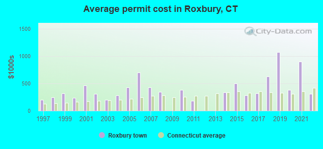
Single-family new house construction building permits:
- 2022: 10 buildings, average cost: $310,000
- 2021: 4 buildings, average cost: $898,600
- 2020: 6 buildings, average cost: $382,200
- 2019: 5 buildings, average cost: $1,070,000
- 2018: 2 buildings, average cost: $625,000
- 2017: 2 buildings, average cost: $317,500
- 2016: 3 buildings, average cost: $280,000
- 2015: 2 buildings, average cost: $500,000
- 2014: 3 buildings, average cost: $338,100
- 2011: 4 buildings, average cost: $182,800
- 2010: 3 buildings, average cost: $383,300
- 2008: 2 buildings, average cost: $347,500
- 2007: 4 buildings, average cost: $423,800
- 2006: 7 buildings, average cost: $694,600
- 2005: 15 buildings, average cost: $422,300
- 2004: 14 buildings, average cost: $280,800
- 2003: 16 buildings, average cost: $201,200
- 2002: 17 buildings, average cost: $307,500
- 2001: 20 buildings, average cost: $460,700
- 2000: 24 buildings, average cost: $238,600
- 1999: 29 buildings, average cost: $318,600
- 1998: 28 buildings, average cost: $242,600
- 1997: 14 buildings, average cost: $197,400
| Here: | 2.1% |
| Connecticut: | 3.9% |
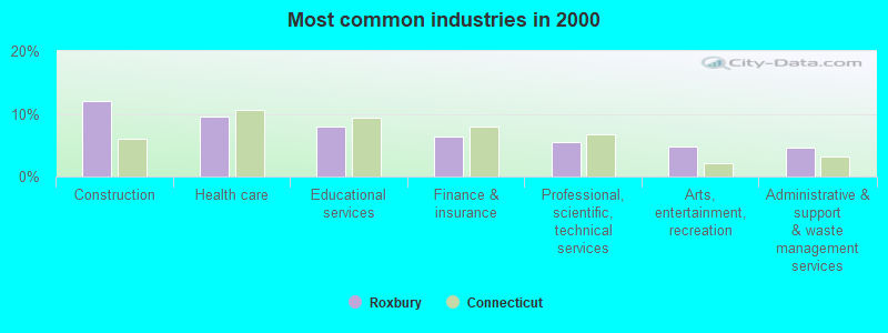
- Construction (12.0%)
- Health care (9.6%)
- Educational services (7.9%)
- Finance & insurance (6.4%)
- Professional, scientific, technical services (5.4%)
- Arts, entertainment, recreation (4.8%)
- Administrative & support & waste management services (4.6%)
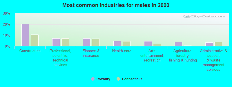
- Construction (20.2%)
- Professional, scientific, technical services (7.1%)
- Finance & insurance (7.1%)
- Health care (4.8%)
- Arts, entertainment, recreation (4.5%)
- Agriculture, forestry, fishing & hunting (4.0%)
- Administrative & support & waste management services (3.5%)
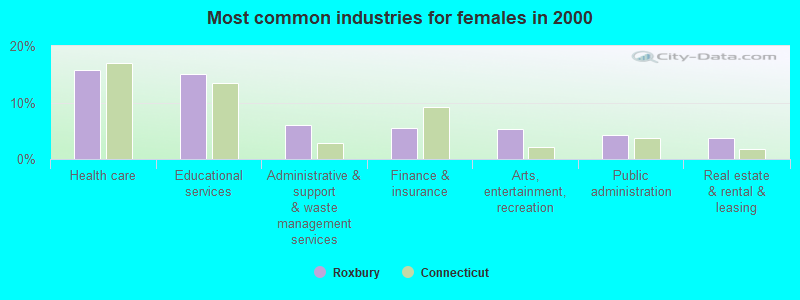
- Health care (15.7%)
- Educational services (15.0%)
- Administrative & support & waste management services (6.0%)
- Finance & insurance (5.5%)
- Arts, entertainment, recreation (5.3%)
- Public administration (4.2%)
- Real estate & rental & leasing (3.6%)
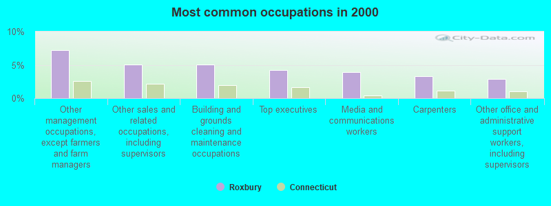
- Other management occupations, except farmers and farm managers (7.2%)
- Other sales and related occupations, including supervisors (5.1%)
- Building and grounds cleaning and maintenance occupations (5.1%)
- Top executives (4.2%)
- Media and communications workers (3.9%)
- Carpenters (3.3%)
- Other office and administrative support workers, including supervisors (2.9%)
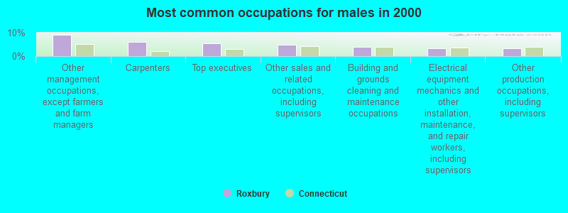
- Other management occupations, except farmers and farm managers (9.0%)
- Carpenters (5.9%)
- Top executives (5.3%)
- Other sales and related occupations, including supervisors (4.9%)
- Building and grounds cleaning and maintenance occupations (3.9%)
- Electrical equipment mechanics and other installation, maintenance, and repair workers, including supervisors (3.5%)
- Other production occupations, including supervisors (3.3%)
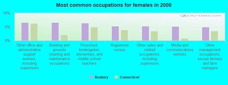
- Other office and administrative support workers, including supervisors (6.6%)
- Building and grounds cleaning and maintenance occupations (6.6%)
- Preschool, kindergarten, elementary, and middle school teachers (6.4%)
- Registered nurses (5.3%)
- Other sales and related occupations, including supervisors (5.3%)
- Media and communications workers (5.1%)
- Other management occupations, except farmers and farm managers (4.9%)
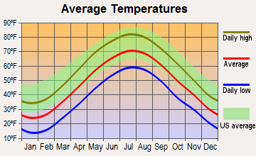
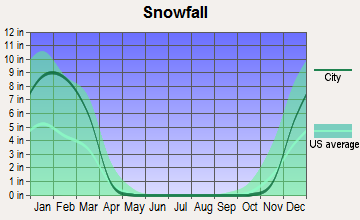
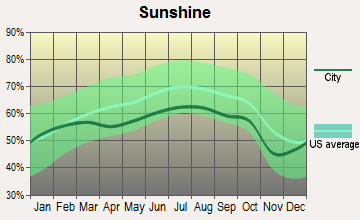
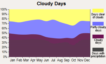
Average climate in Roxbury, Connecticut
Based on data reported by over 4,000 weather stations

(lower is better)
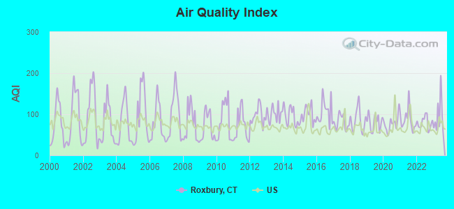
Air Quality Index (AQI) level in 2023 was 92.0. This is worse than average.
| City: | 92.0 |
| U.S.: | 72.6 |
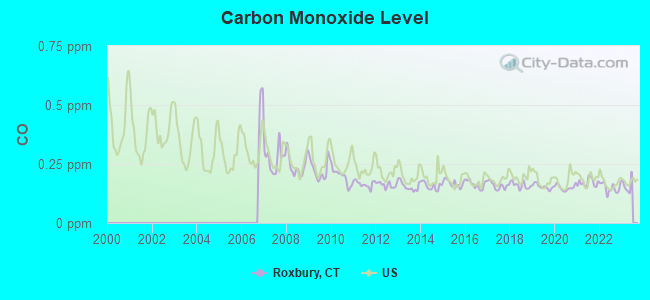
Carbon Monoxide (CO) [ppm] level in 2022 was 0.149. This is significantly better than average. Closest monitor was 13.3 miles away from the city center.
| City: | 0.149 |
| U.S.: | 0.251 |
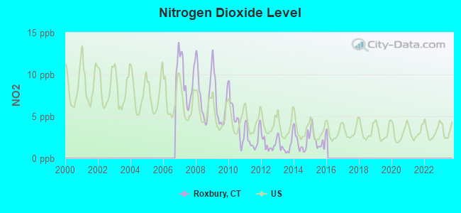
Nitrogen Dioxide (NO2) [ppb] level in 2015 was 2.27. This is significantly better than average. Closest monitor was 11.0 miles away from the city center.
| City: | 2.27 |
| U.S.: | 5.11 |

Sulfur Dioxide (SO2) [ppb] level in 2022 was 0.109. This is significantly better than average. Closest monitor was 11.0 miles away from the city center.
| City: | 0.109 |
| U.S.: | 1.515 |
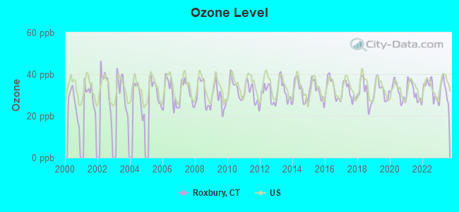
Ozone [ppb] level in 2023 was 31.8. This is about average. Closest monitor was 11.7 miles away from the city center.
| City: | 31.8 |
| U.S.: | 33.3 |
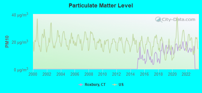
Particulate Matter (PM10) [µg/m3] level in 2022 was 14.8. This is better than average. Closest monitor was 13.0 miles away from the city center.
| City: | 14.8 |
| U.S.: | 19.2 |
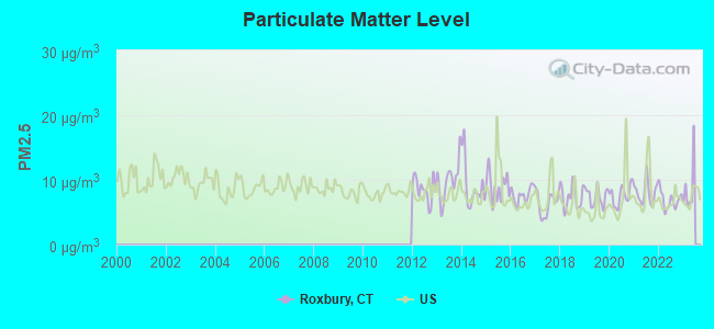
Particulate Matter (PM2.5) [µg/m3] level in 2022 was 6.92. This is about average. Closest monitor was 13.0 miles away from the city center.
| City: | 6.92 |
| U.S.: | 8.11 |
Tornado activity:
Roxbury-area historical tornado activity is near Connecticut state average. It is 25% smaller than the overall U.S. average.
On 7/10/1989, a category F4 (max. wind speeds 207-260 mph) tornado 24.5 miles away from the Roxbury town center injured 40 people and caused between $50,000,000 and $500,000,000 in damages.
On 5/24/1962, a category F3 (max. wind speeds 158-206 mph) tornado 9.8 miles away from the town center killed one person and injured 50 people and caused between $500,000 and $5,000,000 in damages.
Earthquake activity:
Roxbury-area historical earthquake activity is significantly above Connecticut state average. It is 69% smaller than the overall U.S. average.On 10/7/1983 at 10:18:46, a magnitude 5.3 (5.1 MB, 5.3 LG, 5.1 ML, Class: Moderate, Intensity: VI - VII) earthquake occurred 173.8 miles away from Roxbury center
On 4/20/2002 at 10:50:47, a magnitude 5.3 (5.3 ML, Depth: 3.0 mi) earthquake occurred 205.3 miles away from the city center
On 4/20/2002 at 10:50:47, a magnitude 5.2 (5.2 MB, 4.2 MS, 5.2 MW, 5.0 MW) earthquake occurred 203.7 miles away from Roxbury center
On 8/23/2011 at 17:51:04, a magnitude 5.8 (5.8 MW, Depth: 3.7 mi) earthquake occurred 352.4 miles away from Roxbury center
On 1/19/1982 at 00:14:42, a magnitude 4.7 (4.5 MB, 4.7 MD, 4.5 LG, Class: Light, Intensity: IV - V) earthquake occurred 160.1 miles away from the city center
On 1/16/1994 at 01:49:16, a magnitude 4.6 (4.6 MB, 4.6 LG, Depth: 3.1 mi) earthquake occurred 165.9 miles away from the city center
Magnitude types: regional Lg-wave magnitude (LG), body-wave magnitude (MB), duration magnitude (MD), local magnitude (ML), surface-wave magnitude (MS), moment magnitude (MW)
Natural disasters:
The number of natural disasters in Litchfield County (23) is greater than the US average (15).Major Disasters (Presidential) Declared: 13
Emergencies Declared: 10
Causes of natural disasters: Storms: 7, Hurricanes: 5, Floods: 4, Snowstorms: 4, Blizzards: 3, Snows: 2, Tropical Storms: 2, Winter Storms: 2, Snowfall: 1, Tornado: 1, Wind: 1 (Note: some incidents may be assigned to more than one category).

Hospitals and medical centers near Roxbury:
- ABILITY BEYOND DISABILITY GREE (Hospital, about 6 miles away; NEW MILFORD, CT)
- VILLAGE CREST CENTER FOR HEALTH AND REHABILITATION (Nursing Home, about 6 miles away; NEW MILFORD, CT)
- NEW MILFORD HOSPITAL Acute Care Hospitals (about 6 miles away; NEW MILFORD, CT)
- CANDLEWOOD VALLEY HEALTH AND R (Nursing Home, about 6 miles away; NEW MILFORD, CT)
- ABILITY BEYOND DISABILITY LANE (Hospital, about 6 miles away; NEW MILFORD, CT)
- NEW MILFORD VNA INC (Home Health Center, about 6 miles away; NEW MILFORD, CT)
- SPRINGS AT WATERMARK, EAST HILL, THE (Nursing Home, about 6 miles away; SOUTHBURY, CT)
Airports located in Roxbury:
- Good Hill Farm Airport (CT59) (Runways: 1)
Colleges/universities with over 2000 students nearest to Roxbury:
- Post University (about 12 miles; Waterbury, CT; Full-time enrollment: 5,808)
- Naugatuck Valley Community College (about 13 miles; Waterbury, CT; FT enrollment: 4,491)
- Western Connecticut State University (about 13 miles; Danbury, CT; FT enrollment: 5,345)
- University of Connecticut-Tri-Campus (about 14 miles; Waterbury, CT; FT enrollment: 2,250)
- Quinnipiac University (about 24 miles; Hamden, CT; FT enrollment: 8,153)
- Sacred Heart University (about 24 miles; Fairfield, CT; FT enrollment: 5,650)
- Southern Connecticut State University (about 25 miles; New Haven, CT; FT enrollment: 8,708)
Public elementary/middle school in Roxbury:
- BOOTH FREE SCHOOL (Students: 149, Location: 14 SOUTH STREET, Grades: KG-5)
User-submitted facts and corrections:
- Roxbury is next to Washington and is nowhere near the location you have it.
Points of interest:
Notable locations in Roxbury: Judds Bridge (A), Camp Mel (B), Minor Brook (C), Roxbury Town Hall (D), Minot Memorial Library (E), Roxbury Ambulance Association (F), Roxbury Volunteer Fire Department (G). Display/hide their locations on the map
Church in Roxbury: Roxbury Congregational Church (A). Display/hide its location on the map
Cemeteries: Old Leavonworth Cemetery (1), Center Cemetery (2). Display/hide their locations on the map
Reservoir: Lake Hayward (A). Display/hide its location on the map
Streams, rivers, and creeks: Moosehorn Brook (A), Pierce Brook (B), Roxbury Brook (C), Second Hill Brook (D), Battle Swamp Brook (E), Camp Brook (F), Weller Brook (G), Walker Brook (H), Fenn Brook (I). Display/hide their locations on the map
Parks in Roxbury include: Hodge Park (1), Natalie White Preserve (2), Brian E Tierney Preserve (3), Mine Hill Preserve (4), Roxbury Center Historic District (5), River Road Reserve (6), Lilly Preserve (7). Display/hide their locations on the map
Birthplace of: Rebecca Miller - Film actor, Truman Smith - Politician, Seth Warner - Continental Army officer.
Drinking water stations with addresses in Roxbury and their reported violations in the past:
BERNHARDT MEADOW (Population served: 36, Groundwater):Past health violations:Past monitoring violations:
- MCL, Monthly (TCR) - In AUG-2011, Contaminant: Coliform. Follow-up actions: St Public Notif received (SEP-03-2011), St Public Notif requested (SEP-19-2011), St Violation/Reminder Notice (SEP-19-2011), St Compliance achieved (SEP-30-2011)
- MCL, Monthly (TCR) - In JUL-2011, Contaminant: Coliform. Follow-up actions: St Public Notif received (AUG-02-2011), St Public Notif requested (SEP-27-2011), St Violation/Reminder Notice (SEP-27-2011), St Compliance achieved (SEP-30-2011)
- MCL, Monthly (TCR) - In JUN-2008, Contaminant: Coliform. Follow-up actions: St Public Notif requested (JUL-09-2008), St Violation/Reminder Notice (JUL-09-2008), St Public Notif received (JUL-18-2008), St Compliance achieved (JUL-31-2008)
- One routine major monitoring violation
| This town: | 2.4 people |
| Connecticut: | 2.5 people |
| This town: | 70.4% |
| Whole state: | 66.3% |
| This town: | 6.0% |
| Whole state: | 6.6% |
Likely homosexual households (counted as self-reported same-sex unmarried-partner households)
- Lesbian couples: 0.3% of all households
- Gay men: 1.9% of all households
| This town: | 3.9% |
| Whole state: | 7.9% |
| This town: | 2.1% |
| Whole state: | 3.9% |
Banks with branches in Roxbury (2011 data):
- Union Savings Bank: Roxbury Branch at Route 67, Box 301, branch established on 1989/05/15. Info updated 2011/11/30: Bank assets: $2,496.5 mil, Deposits: $1,625.1 mil, headquarters in Danbury, CT, positive income, Mortgage Lending Specialization, 29 total offices
For population 15 years and over in Roxbury:
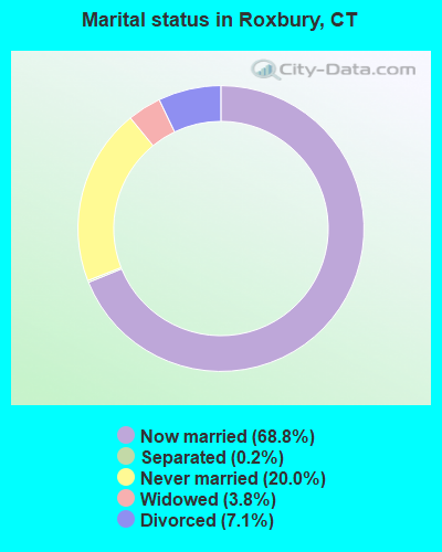
- Never married: 20.0%
- Now married: 68.8%
- Separated: 0.2%
- Widowed: 3.8%
- Divorced: 7.1%
For population 25 years and over in Roxbury:
- High school or higher: 96.2%
- Bachelor's degree or higher: 46.6%
- Graduate or professional degree: 21.4%
- Unemployed: 2.2%
- Mean travel time to work (commute): 35.1 minutes
| Here: | 9.5 |
| Connecticut average: | 12.8 |
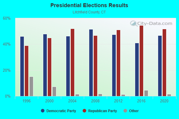
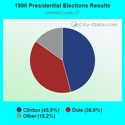
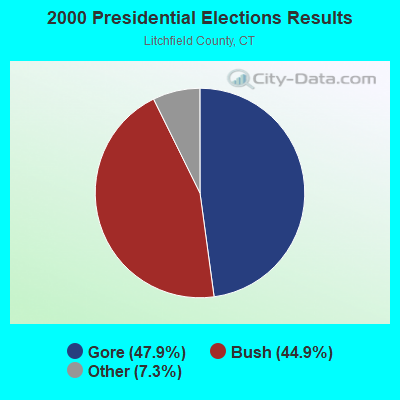
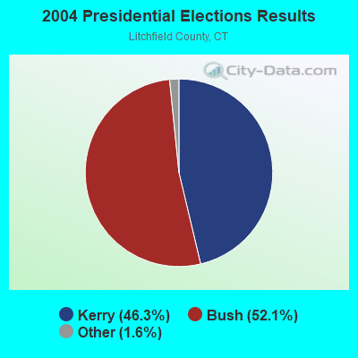
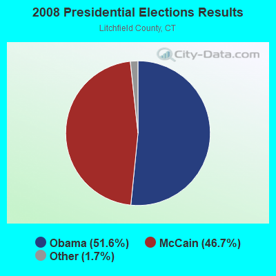
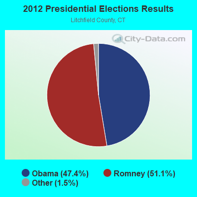
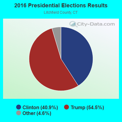
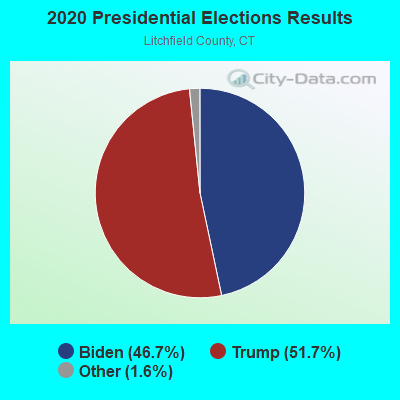
Graphs represent county-level data. Detailed 2008 Election Results
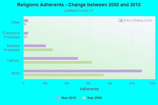
Religion statistics for Roxbury, CT (based on Litchfield County data)
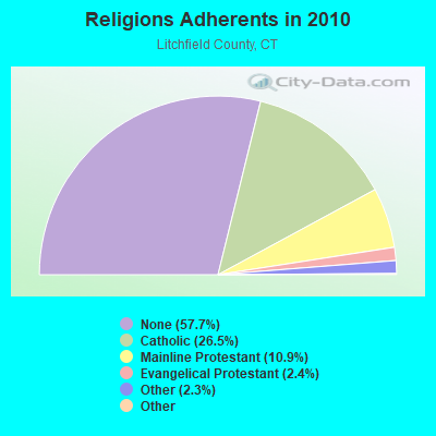
| Religion | Adherents | Congregations |
|---|---|---|
| Catholic | 50,354 | 30 |
| Mainline Protestant | 20,681 | 87 |
| Evangelical Protestant | 4,483 | 39 |
| Other | 4,420 | 16 |
| Orthodox | 175 | 2 |
| Black Protestant | 160 | 2 |
| None | 109,654 | - |
Food Environment Statistics:
| Here: | 2.29 / 10,000 pop. |
| Connecticut: | 2.21 / 10,000 pop. |
| Litchfield County: | 0.05 / 10,000 pop. |
| State: | 0.07 / 10,000 pop. |
| Here: | 0.64 / 10,000 pop. |
| Connecticut: | 1.02 / 10,000 pop. |
| This county: | 2.98 / 10,000 pop. |
| Connecticut: | 2.27 / 10,000 pop. |
| Litchfield County: | 11.07 / 10,000 pop. |
| Connecticut: | 9.19 / 10,000 pop. |
| Litchfield County: | 6.9% |
| Connecticut: | 7.3% |
| Here: | 21.1% |
| Connecticut: | 21.5% |
| Here: | 11.8% |
| State: | 15.8% |
Strongest AM radio stations in Roxbury:
- WTIC (1080 AM; 50 kW; HARTFORD, CT; Owner: INFINITY RADIO OPERATIONS INC.)
- WNNZ (640 AM; 50 kW; WESTFIELD, MA; Owner: CLEAR CHANNEL BROADCASTING LICENSES, INC.)
- WFAN (660 AM; 50 kW; NEW YORK, NY; Owner: INFINITY BROADCASTING OPERATIONS, INC.)
- WFNW (1380 AM; 5 kW; NAUGATUCK, CT; Owner: CANDIDO DIAS CARRELO)
- WCBS (880 AM; 50 kW; NEW YORK, NY; Owner: INFINITY BROADCASTING OPERATIONS, INC.)
- WATR (1320 AM; 5 kW; WATERBURY, CT; Owner: WATR, INC.)
- WMCA (570 AM; 50 kW; NEW YORK, NY; Owner: SALEM MEDIA OF NEW YORK, LLC)
- WABC (770 AM; 50 kW; NEW YORK, NY; Owner: WABC-AM RADIO, INC.)
- WOR (710 AM; 50 kW; NEW YORK, NY; Owner: BUCKLEY BROADCASTING CORPORATION)
- WADS (690 AM; daytime; 3 kW; ANSONIA, CT; Owner: RADIO AMOR, INC.)
- WGSM (740 AM; 25 kW; HUNTINGTON, NY; Owner: K RADIO LICENSEE, INC.)
- WINE (940 AM; 1 kW; BROOKFIELD, CT; Owner: CUMULUS LICENSING CORP.)
- WEPN (1050 AM; 50 kW; NEW YORK, NY; Owner: NEW YORK AM RADIO, LLC)
Strongest FM radio stations in Roxbury:
- WRKI (95.1 FM; BROOKFIELD, CT; Owner: CUMULUS LICENSING CORP.)
- WKCI-FM (101.3 FM; HAMDEN, CT; Owner: CLEAR CHANNEL BROADCASTING LICENSES, INC.)
- W218AV (91.5 FM; WARREN, CT; Owner: MONROE BOARD OF EDUCATION)
- W206AW (89.1 FM; PAWLING, NY; Owner: SOUND OF LIFE, INC.)
- WPLR (99.1 FM; NEW HAVEN, CT; Owner: COX RADIO, INC.)
- WRCH (100.5 FM; NEW BRITAIN, CT; Owner: INFINITY RADIO OPERATIONS INC.)
- WDAQ (98.3 FM; DANBURY, CT; Owner: BERKSHIRE BROADCASTING CORP.)
- WDBY (105.5 FM; PATTERSON, NY; Owner: CUMULUS LICENSING CORP.)
- WWYZ (92.5 FM; WATERBURY, CT; Owner: CAPSTAR TX LIMITED PARTNERSHIP)
- WKSS (95.7 FM; HARTFORD-MERIDEN, CT; Owner: CAPSTAR TX LIMITED PARTNERSHIP)
- WZMX (93.7 FM; HARTFORD, CT; Owner: INFINITY RADIO OPERATIONS INC.)
- WHCN (105.9 FM; HARTFORD, CT; Owner: CAPSTAR TX LIMITED PARTNERSHIP)
- WPDH (101.5 FM; POUGHKEEPSIE, NY; Owner: CUMULUS LICENSING CORP.)
- WRNQ (92.1 FM; POUGHKEEPSIE, NY; Owner: CLEAR CHANNEL BROADCASTING LICENSES, INC.)
- WMRQ (104.1 FM; WATERBURY, CT; Owner: CAPSTAR TX LIMITED PARTNERSHIP)
- WEZN-FM (99.9 FM; BRIDGEPORT, CT; Owner: CXR HOLDINGS, INC.)
- WPKT (90.5 FM; MERIDEN, CT; Owner: CONNECTICUT PUBLIC BROADCASTING, INC)
- WDRC-FM (102.9 FM; HARTFORD, CT; Owner: BUCKLEY BROADCASTING CORPORATION)
- WSPK (104.7 FM; POUGHKEEPSIE, NY; Owner: 6 JOHNSON ROAD LICENSES, INC.)
- WSHU-FM (91.1 FM; FAIRFIELD, CT; Owner: SACRED HEART UNIVERSITY, INC.)
TV broadcast stations around Roxbury:
- WTIC-TV (Channel 61; HARTFORD, CT; Owner: TRIBUNE TELEVISION COMPANY)
- W11BJ (Channel 11; HARTFORD, CT; Owner: COMMUNICATIONS SITE MANAGEMENT LLC)
- WTXX (Channel 20; WATERBURY, CT; Owner: WTXX INC.)
- WTNH (Channel 8; NEW HAVEN, CT; Owner: WTNH BROADCASTING, INC.)
- WVIT (Channel 30; NEW BRITAIN, CT; Owner: OUTLET BROADCASTING, INC)
- WCTX (Channel 59; NEW HAVEN, CT; Owner: WTNH BROADCASTING, INC.)
- WEDY (Channel 65; NEW HAVEN, CT; Owner: CONNECTICUT PUBLIC BROADCASTING, INC.)
- WEDH (Channel 24; HARTFORD, CT; Owner: CONNECTICUT PUBLIC BROADCASTING, INC.)
- WUVN (Channel 18; HARTFORD, CT; Owner: ENTRAVISION HOLDINGS, LLC)
- WEDW (Channel 49; BRIDGEPORT, CT; Owner: CONNECTICUT PUBLIC BROADCASTING, INC.)
- WTBY (Channel 54; POUGHKEEPSIE, NY; Owner: TRINITY BROADCASTING OF NEW YORK, INC.)
- WFSB (Channel 3; HARTFORD, CT; Owner: MEREDITH CORPORATION)
- WSAH (Channel 43; BRIDGEPORT, CT; Owner: WSAH LICENSE, INC.)
- W12BH (Channel 12; WATERBURY, CT; Owner: CONN.PUBLIC BROADCASTING, INC.)
- W22BN (Channel 22; DANBURY, CT; Owner: it COMMUNICATIONS, INC.)

- National Bridge Inventory (NBI) Statistics
- 7Number of bridges
- 36ft / 10.6mTotal length
- 13,640Total average daily traffic
- 772Total average daily truck traffic
- 20,268Total future (year 2037) average daily traffic
FCC Registered Cell Phone Towers:
1- 35 Lower County Rd (Lat: 41.559611 Lon: -73.292222), Type: Ltower, Structure height: 54.9 m, Overall height: 57.9 m, Call Sign: KNKN589
Assigned Frequencies: 880.020 MHz, 880.020 MHz, 880.020 MHz, 835.020 MHz, 835.020 MHz, 835.020 MHz, 891.510 MHz, 891.510 MHz, 891.510 MHz, 846.510 MHz, 846.510 MHz, 846.510 MHzGrant Date: 09/01/2020, Expiration Date: 10/01/2030, Certifier: David C JatlowRegistrant: At&t Services, Inc., 208 S Akard St, 20f, Dallas, TX 75202, Phone: (855) 699-7073, Fax: (214) 746-6410, Email:
FCC Registered Antenna Towers:
5- Richard Byrne, Lower County Road (Lat: 41.559528 Lon: -73.292306), Type: 59.4, Overall height: 55.2 m, Registrant: Towerco Assets LLC, Afry@towerco.Com, , Cary, Phone: (919) 653-5710
- Richard Byrne, Lower County Road (Lat: 41.559528 Lon: -73.292306), Type: 59.4, Overall height: 55.2 m, Registrant: Towerco Assets LLC, Afry@towerco.Com, , Cary, Phone: (919) 653-5710
- Edward G Roach, Lower County Road (Lat: 41.559528 Lon: -73.292306), Type: 59.4, Structure height: 09005 m, Overall height: 55.2 m, Registrant: Sba 2012 Tc Assets, LLC, Eroach@sbasite.Com, , Boca -Raton, Phone: (561) 995-7670
- Edward G Roach, 35 Lower County Road (Ct46125-A) (Lat: 41.559611 Lon: -73.292222), Type: 59.4, Structure height: 09005 m, Overall height: 54.9 m, Registrant: Sba 2012 Tc Assets, LLC, Eroach@sbasite.Com, , Boca -Raton, Phone: (561) 995-7670
- Edward G Roach, 35 Lower County Road (Ct46125-A) (Lat: 41.559611 Lon: -73.292222), Type: 59.4, Structure height: 09005 m, Overall height: 54.9 m, Registrant: Sba 2012 Tc Assets, LLC, Eroach@sbasite.Com, , Boca -Raton, Phone: (561) 995-7670
FCC Registered Broadcast Land Mobile Towers:
2- SOUTHBURY TRAINING, West Flagg Swamp Rd (Lat: 41.506194 Lon: -73.283444), Type: Tower, Structure height: 54.9 m, Call Sign: KCG288,
Assigned Frequencies: 47.1600 MHz, 47.3000 MHz, 47.3800 MHz, Grant Date: 07/08/2015, Expiration Date: 10/04/2025, Certifier: James H Bayer, Registrant: State Of Connecticut Department Of Transportation, 280 West Street, Rocky Hill, CT 06067, Phone: (860) 258-0376, Fax: (860) 258-0399, Email:
- NEW MILFORD, Lower County Road (Lat: 41.559417 Lon: -73.292778), Type: Tower, Structure height: 48.8 m, Overall height: 55 m, Call Sign: WQKF294,
Assigned Frequencies: 463.000 MHz, 463.025 MHz, 463.050 MHz, 463.075 MHz, 463.100 MHz, 463.125 MHz, 463.150 MHz, 463.175 MHz, 462.950 MHz, 462.975 MHz, Grant Date: 02/02/2019, Expiration Date: 04/27/2029, Certifier: Steven M Savage, Registrant: Northeastern Communications Inc., 7 Great Hill Rd, N, CT 06770, Phone: (203) 575-9008, Email:
FCC Registered Paging Towers:
1- Route 317 & Upper Grassy Hill Road (Lat: 41.557306 Lon: -73.260667), Call Sign: KNKH919,
Assigned Frequencies: 931.062 MHz, 931.612 MHz, Grant Date: 04/27/1999, Expiration Date: 04/01/2009, Cancellation Date: 01/30/2009, Certifier: Shawn E Endsley, Registrant: Usa Mobility Wireless, Inc., 300 Technology Drive #400, Plano, TX 75074, Phone: (972) 801-1626, Fax: (972) 801-1699, Email:
FCC Registered Amateur Radio Licenses:
16 (See the full list of FCC Registered Amateur Radio Licenses in Roxbury)FAA Registered Aircraft:
22 (See the full list of FAA Registered Aircraft in Roxbury)2002 - 2018 National Fire Incident Reporting System (NFIRS) incidents
- Fire incident types reported to NFIRS in Roxbury, CT
- 6446.0%Structure Fires
- 3525.2%Outside Fires
- 2215.8%Other
- 1812.9%Mobile Property/Vehicle Fires
 According to the data from the years 2002 - 2018 the average number of fires per year is 8. The highest number of fires - 20 took place in 2013, and the least - 1 in 2005. The data has a growing trend.
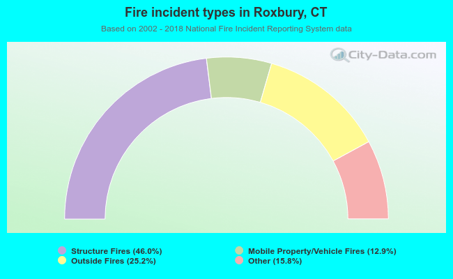 When looking into fire subcategories, the most incidents belonged to: Structure Fires (46.0%), and Outside Fires (25.2%).
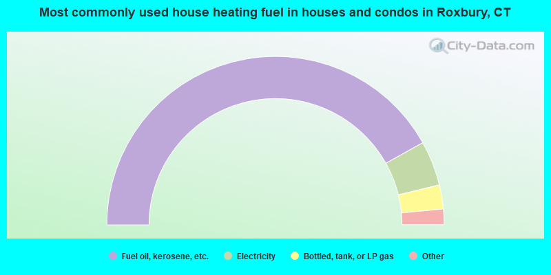
- 83.8%Fuel oil, kerosene, etc.
- 8.6%Electricity
- 4.6%Bottled, tank, or LP gas
- 2.4%Wood
- 0.5%Other fuel
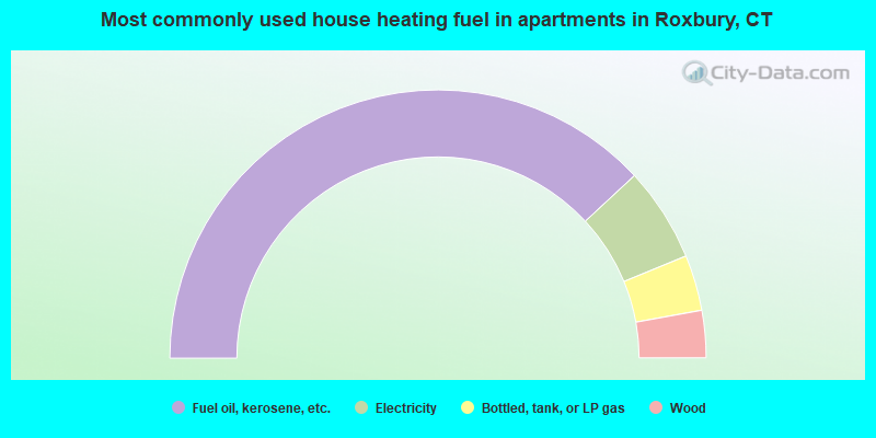
- 76.2%Fuel oil, kerosene, etc.
- 11.4%Electricity
- 6.7%Bottled, tank, or LP gas
- 5.7%Wood
Roxbury compared to Connecticut state average:
- Median household income above state average.
- Median house value significantly above state average.
- Unemployed percentage significantly below state average.
- Black race population percentage significantly below state average.
- Hispanic race population percentage significantly below state average.
- Median age significantly above state average.
- Foreign-born population percentage significantly below state average.
- Renting percentage below state average.
- Length of stay since moving in significantly above state average.
- Number of rooms per house significantly below state average.
- House age significantly below state average.
- Number of college students below state average.
- Percentage of population with a bachelor's degree or higher above state average.

|
|
Total of 142 patent applications in 2008-2024.