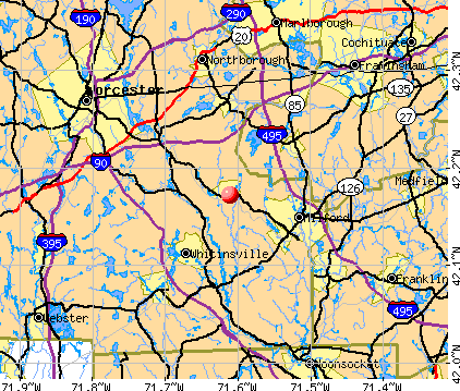
Upton-West Upton, Massachusetts
Submit your own pictures of this place and show them to the world
- OSM Map
- General Map
- Google Map
- MSN Map
| Males: 1,147 | |
| Females: 1,312 |
| Median resident age: | 36.7 years |
| Massachusetts median age: | 36.5 years |
Zip codes: 01568.
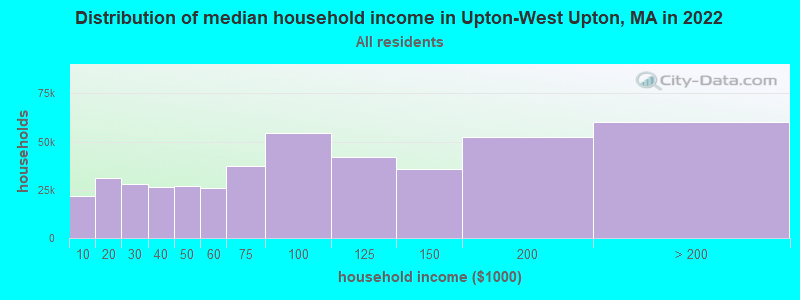
| Upton-West Upton: | $112,751 |
| MA: | $94,488 |
Estimated per capita income in 2022: $51,673 (it was $26,502 in 2000)
Upton-West Upton CDP income, earnings, and wages data
Estimated median house or condo value in 2022: $568,055 (it was $205,700 in 2000)
| Upton-West Upton: | $568,055 |
| MA: | $534,700 |
Mean prices in 2022: all housing units: $419,164; detached houses: $447,621; townhouses or other attached units: $343,592; in 2-unit structures: $323,295; in 3-to-4-unit structures: $332,295; in 5-or-more-unit structures: $232,758; mobile homes: $113,885
Upton-West Upton, MA residents, houses, and apartments details
Detailed information about poverty and poor residents in Upton-West Upton, MA


- 2,25396.9%White alone
- 241.0%Asian alone
- 200.9%Two or more races
- 160.7%Hispanic
- 100.4%Black alone
- 20.09%Other race alone
- 10.04%American Indian alone
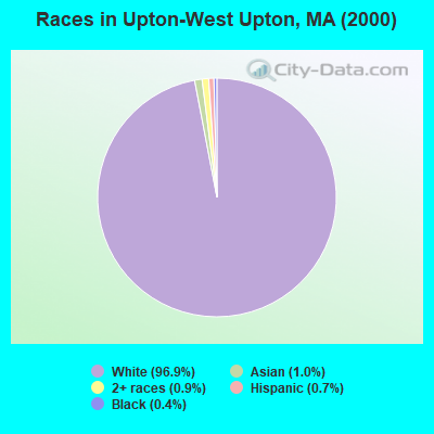
Races in Upton-West Upton detailed stats: ancestries, foreign born residents, place of birth
 Recent articles from our blog. Our writers, many of them Ph.D. graduates or candidates, create easy-to-read articles on a wide variety of topics.


Ancestries: Irish (26.5%), English (17.0%), French (16.5%), Italian (15.3%), United States (8.1%), German (7.3%).
Current Local Time: EST time zone
Land area: 2.49 square miles.
Population density: 989 people per square mile (low).
32 residents are foreign born
| This place: | 1.4% |
| Massachusetts: | 12.2% |
| Upton-West Upton CDP: | 1.0% ($2,110) |
| Massachusetts: | 1.3% ($2,336) |
Nearest city with pop. 50,000+: Worcester, MA  (11.9 miles , pop. 172,648).
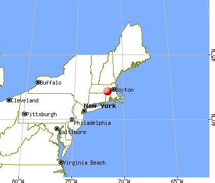
Nearest city with pop. 200,000+: Boston, MA (28.7 miles , pop. 589,141).
Nearest city with pop. 1,000,000+: Bronx, NY (148.7 miles , pop. 1,332,650).
Nearest cities:
), ), Latitude: 42.17 N, Longitude: 71.61 W

| Here: | 3.6% |
| Massachusetts: | 3.5% |
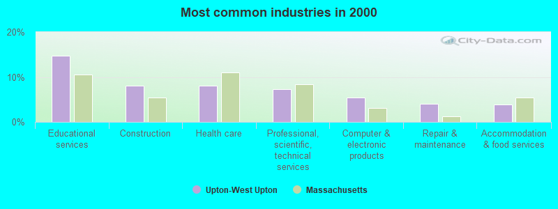
- Educational services (14.8%)
- Construction (8.1%)
- Health care (8.0%)
- Professional, scientific, technical services (7.3%)
- Computer & electronic products (5.4%)
- Repair & maintenance (4.1%)
- Accommodation & food services (3.9%)
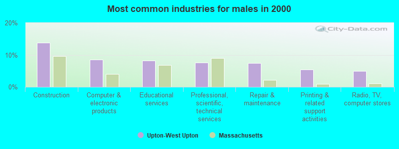
- Construction (13.8%)
- Computer & electronic products (8.6%)
- Educational services (8.3%)
- Professional, scientific, technical services (7.7%)
- Repair & maintenance (7.5%)
- Printing & related support activities (5.4%)
- Radio, TV, computer stores (5.0%)
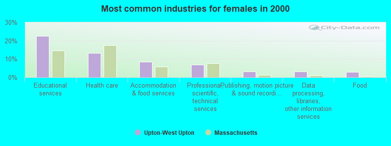
- Educational services (22.5%)
- Health care (13.4%)
- Accommodation & food services (8.6%)
- Professional, scientific, technical services (7.0%)
- Publishing, motion picture & sound recording industries (3.2%)
- Data processing, libraries, other information services (3.2%)
- Food (3.0%)
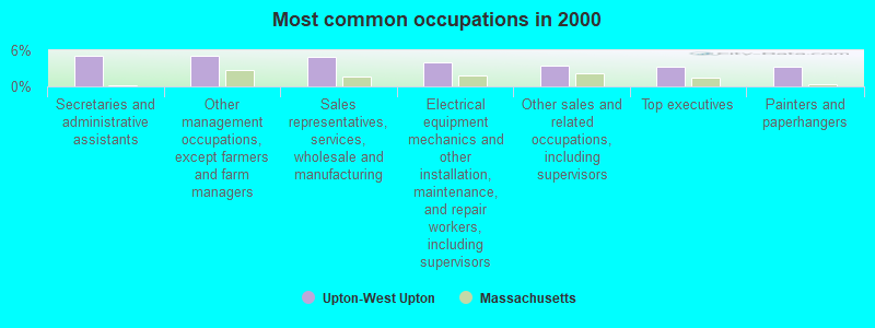
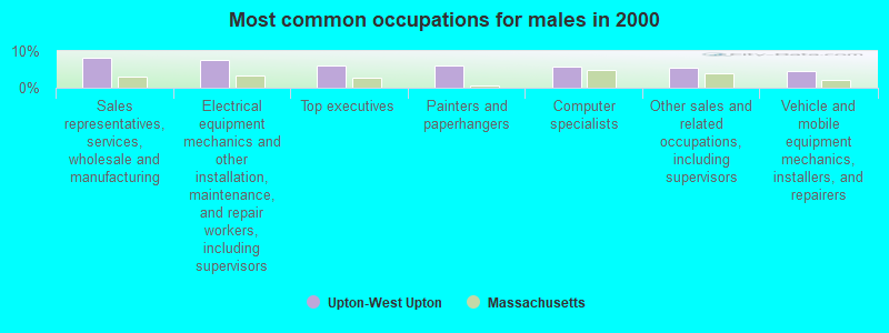
- Secretaries and administrative assistants (5.1%)
- Other management occupations, except farmers and farm managers (5.1%)
- Sales representatives, services, wholesale and manufacturing (4.9%)
- Electrical equipment mechanics and other installation, maintenance, and repair workers, including supervisors (4.1%)
- Other sales and related occupations, including supervisors (3.4%)
- Top executives (3.3%)
- Painters and paperhangers (3.3%)
- Sales representatives, services, wholesale and manufacturing (8.3%)
- Electrical equipment mechanics and other installation, maintenance, and repair workers, including supervisors (7.5%)
- Top executives (6.2%)
- Painters and paperhangers (6.2%)
- Computer specialists (5.7%)
- Other sales and related occupations, including supervisors (5.4%)
- Vehicle and mobile equipment mechanics, installers, and repairers (4.5%)
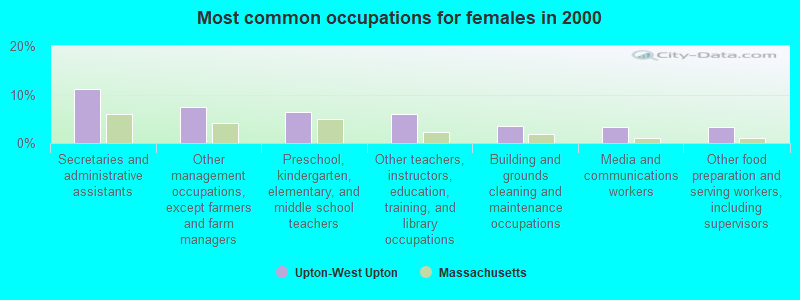
- Secretaries and administrative assistants (11.2%)
- Other management occupations, except farmers and farm managers (7.5%)
- Preschool, kindergarten, elementary, and middle school teachers (6.4%)
- Other teachers, instructors, education, training, and library occupations (6.1%)
- Building and grounds cleaning and maintenance occupations (3.6%)
- Media and communications workers (3.4%)
- Other food preparation and serving workers, including supervisors (3.2%)
Average climate in Upton-West Upton, Massachusetts
Based on data reported by over 4,000 weather stations


(lower is better)
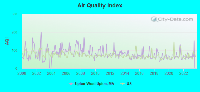
Air Quality Index (AQI) level in 2022 was 64.6. This is about average.
| City: | 64.6 |
| U.S.: | 72.6 |
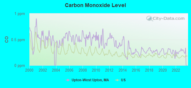
Carbon Monoxide (CO) [ppm] level in 2022 was 0.259. This is about average. Closest monitor was 11.4 miles away from the city center.
| City: | 0.259 |
| U.S.: | 0.251 |
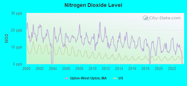
Nitrogen Dioxide (NO2) [ppb] level in 2022 was 10.1. This is significantly worse than average. Closest monitor was 10.4 miles away from the city center.
| City: | 10.1 |
| U.S.: | 5.1 |
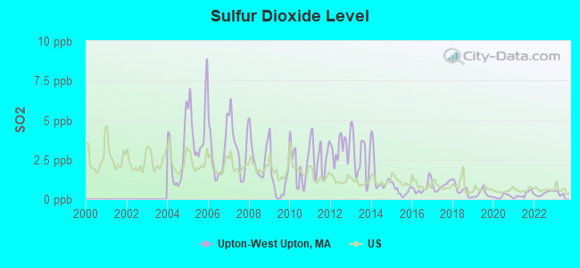
Sulfur Dioxide (SO2) [ppb] level in 2022 was 0.370. This is significantly better than average. Closest monitor was 9.6 miles away from the city center.
| City: | 0.370 |
| U.S.: | 1.515 |
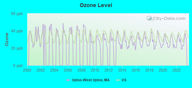
Ozone [ppb] level in 2022 was 27.3. This is better than average. Closest monitor was 5.0 miles away from the city center.
| City: | 27.3 |
| U.S.: | 33.3 |
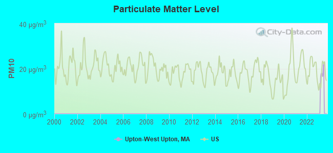
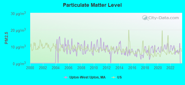
Particulate Matter (PM2.5) [µg/m3] level in 2022 was 8.39. This is about average. Closest monitor was 11.4 miles away from the city center.
| City: | 8.39 |
| U.S.: | 8.11 |
Tornado activity:
Upton-West Upton-area historical tornado activity is slightly above Massachusetts state average. It is 29% smaller than the overall U.S. average.
On 6/9/1953, a category F4 (max. wind speeds 207-260 mph) tornado 10.0 miles away from the Upton-West Upton place center killed 90 people and injured 1228 people and caused between $50,000,000 and $500,000,000 in damages.
On 6/9/1953, a category F3 (max. wind speeds 158-206 mph) tornado 8.2 miles away from the place center injured 17 people and caused between $500,000 and $5,000,000 in damages.
Earthquake activity:
Upton-West Upton-area historical earthquake activity is significantly above Massachusetts state average. It is 72% smaller than the overall U.S. average.On 10/7/1983 at 10:18:46, a magnitude 5.3 (5.1 MB, 5.3 LG, 5.1 ML, Class: Moderate, Intensity: VI - VII) earthquake occurred 185.0 miles away from the city center
On 4/20/2002 at 10:50:47, a magnitude 5.3 (5.3 ML, Depth: 3.0 mi) earthquake occurred 192.9 miles away from Upton-West Upton center
On 4/20/2002 at 10:50:47, a magnitude 5.2 (5.2 MB, 4.2 MS, 5.2 MW, 5.0 MW) earthquake occurred 192.0 miles away from the city center
On 1/19/1982 at 00:14:42, a magnitude 4.7 (4.5 MB, 4.7 MD, 4.5 LG, Class: Light, Intensity: IV - V) earthquake occurred 91.9 miles away from the city center
On 10/16/2012 at 23:12:25, a magnitude 4.7 (4.7 ML, Depth: 10.0 mi) earthquake occurred 109.8 miles away from the city center
On 8/22/1992 at 12:20:32, a magnitude 4.8 (4.8 MB, 3.8 MS, 4.7 LG, Depth: 6.2 mi) earthquake occurred 222.6 miles away from Upton-West Upton center
Magnitude types: regional Lg-wave magnitude (LG), body-wave magnitude (MB), duration magnitude (MD), local magnitude (ML), surface-wave magnitude (MS), moment magnitude (MW)
Natural disasters:
The number of natural disasters in Worcester County (27) is a lot greater than the US average (15).Major Disasters (Presidential) Declared: 15
Emergencies Declared: 12
Causes of natural disasters: Floods: 9, Storms: 8, Hurricanes: 6, Snowstorms: 5, Winter Storms: 4, Blizzards: 2, Snows: 2, Fire: 1, Heavy Rain: 1, Snowfall: 1, Tornado: 1, Wind: 1 (Note: some incidents may be assigned to more than one category).

Hospitals and medical centers near Upton-West Upton:
- UPTON NURSING CENTER, INC (Nursing Home, about 2 miles away; UPTON, MA)
- BEAUMONT N H (Nursing Home, about 3 miles away; NORTHBRIDGE, MA)
- BEAUMONT REHAB AND SKILLED NURSING CTR - NORTHBRIDGE (Nursing Home, about 3 miles away; NORTHBRIDGE, MA)
- NORTHBRIDGE NURS RETIREMENT HOME (Nursing Home, about 3 miles away; NORTHBRIDGE, MA)
- NORTHBRIDGE NURSING HOME (Nursing Home, about 3 miles away; NORTHBRIDGE, MA)
- NORTHBRIDGE REHABILITATION AND NURSING CENTER (Nursing Home, about 3 miles away; NORTHBRIDGE, MA)
- KEITH HILL NURSING HOME, INC (Nursing Home, about 5 miles away; GRAFTON, MA)
Amtrak stations near Upton-West Upton:
- 12 miles: WORCESTER (WORCHESTER, 45 SHREWSBURY ST.) . Services: ticket office, fully wheelchair accessible, enclosed waiting area, public restrooms, public payphones, vending machines, free short-term parking, free long-term parking, call for taxi service, public transit connection.
- 13 miles: FRAMINGHAM (443 WAVERLY ST.) . Services: public payphones, snack bar, paid short-term parking, taxi stand, public transit connection.
Colleges/universities with over 2000 students nearest to Upton-West Upton:
- College of the Holy Cross (about 12 miles; Worcester, MA; Full-time enrollment: 3,125)
- Clark University (about 13 miles; Worcester, MA; FT enrollment: 3,687)
- Worcester Polytechnic Institute (about 13 miles; Worcester, MA; FT enrollment: 3,930)
- Framingham State University (about 13 miles; Framingham, MA; FT enrollment: 5,743)
- Quinsigamond Community College (about 14 miles; Worcester, MA; FT enrollment: 5,877)
- Worcester State University (about 14 miles; Worcester, MA; FT enrollment: 5,426)
- Assumption College (about 15 miles; Worcester, MA; FT enrollment: 2,580)
Points of interest:
Notable locations in Upton-West Upton: Upton Department of Emergency Medical Services (A), Upton Fire Department (B). Display/hide their locations on the map
Cemetery: Lakeview Cemetery (1). Display/hide its location on the map
Lakes: Baker Pond (A), Mill Pond (B), Pratt Pond (C). Display/hide their locations on the map
Streams, rivers, and creeks: Warren Brook (A). Display/hide its location on the map
| This place: | 2.5 people |
| Massachusetts: | 2.5 people |
| This place: | 67.6% |
| Whole state: | 65.0% |
| This place: | 5.0% |
| Whole state: | 5.4% |
Likely homosexual households (counted as self-reported same-sex unmarried-partner households)
- Lesbian couples: 0.3% of all households
- Gay men: 0.2% of all households
| This place: | 5.3% |
| Whole state: | 9.3% |
| This place: | 2.7% |
| Whole state: | 4.4% |
For population 15 years and over in Upton-West Upton:
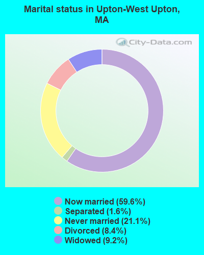
- Never married: 21.1%
- Now married: 59.6%
- Separated: 1.6%
- Widowed: 9.2%
- Divorced: 8.4%
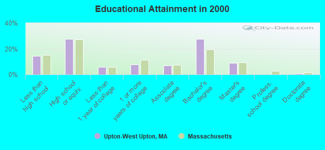
For population 25 years and over in Upton-West Upton:
- High school or higher: 85.6%
- Bachelor's degree or higher: 37.1%
- Graduate or professional degree: 9.6%
- Unemployed: 4.1%
- Mean travel time to work (commute): 30.4 minutes
| Here: | 11.4 |
| Massachusetts average: | 13.1 |


Graphs represent county-level data. Detailed 2008 Election Results
Religion statistics for Upton-West Upton, MA (based on Worcester County data)


| Religion | Adherents | Congregations |
|---|---|---|
| Catholic | 306,925 | 118 |
| Mainline Protestant | 43,326 | 171 |
| Evangelical Protestant | 37,511 | 203 |
| Other | 18,931 | 69 |
| Orthodox | 7,935 | 15 |
| Black Protestant | 497 | 6 |
| None | 383,427 | - |
Food Environment Statistics:
| Worcester County: | 1.73 / 10,000 pop. |
| Massachusetts: | 1.98 / 10,000 pop. |
| Worcester County: | 0.05 / 10,000 pop. |
| Massachusetts: | 0.05 / 10,000 pop. |
| Worcester County: | 1.79 / 10,000 pop. |
| Massachusetts: | 2.22 / 10,000 pop. |
| Here: | 2.22 / 10,000 pop. |
| State: | 1.77 / 10,000 pop. |
| Worcester County: | 7.27 / 10,000 pop. |
| Massachusetts: | 8.76 / 10,000 pop. |
| Worcester County: | 8.0% |
| Massachusetts: | 8.1% |
| Here: | 24.0% |
| State: | 22.5% |
| Worcester County: | 16.6% |
| State: | 16.5% |
4.71% of this county's 2021 resident taxpayers lived in other counties in 2020 ($76,229 average adjusted gross income)
| Here: | 4.71% |
| Massachusetts average: | 6.35% |
0.02% of residents moved from foreign countries ($100 average AGI)
Worcester County: 0.02% Massachusetts average: 0.01%
Top counties from which taxpayers relocated into this county between 2020 and 2021:
| from Middlesex County, MA | |
| from Norfolk County, MA | |
| from Suffolk County, MA |
4.84% of this county's 2020 resident taxpayers moved to other counties in 2021 ($87,252 average adjusted gross income)
| Here: | 4.84% |
| Massachusetts average: | 7.18% |
0.03% of residents moved to foreign countries ($199 average AGI)
Worcester County: 0.03% Massachusetts average: 0.02%
Top counties to which taxpayers relocated from this county between 2020 and 2021:
| to Middlesex County, MA | |
| to Norfolk County, MA | |
| to Suffolk County, MA |
Strongest AM radio stations in Upton-West Upton:
- WKOX (1200 AM; 50 kW; FRAMINGHAM, MA; Owner: CAPSTAR TX LIMITED PARTNERSHIP)
- WBIX (1060 AM; 40 kW; NATICK, MA; Owner: LANGER BROADCASTING CORPORATION)
- WAMG (890 AM; 25 kW; DEDHAM, MA; Owner: MEGA COMMUNICATIONS OF DEDHAM LICENSEE, LLC)
- WALE (990 AM; 50 kW; GREENVILLE, RI; Owner: NORTH AMERICAN BROADCASTING CO., INC.)
- WCRN (830 AM; 50 kW; WORCESTER, MA; Owner: CARTER BROADCASTING CORPORATION)
- WEEI (850 AM; 50 kW; BOSTON, MA; Owner: ENTERCOM BOSTON LICENSE, LLC)
- WRKO (680 AM; 50 kW; BOSTON, MA; Owner: ENTERCOM BOSTON LICENSE, LLC)
- WVNE (760 AM; daytime; 25 kW; LEICESTER, MA; Owner: BLOUNT MASSCOM, INC.)
- WWZN (1510 AM; 50 kW; BOSTON, MA; Owner: ROSE CITY RADIO CORPORATION)
- WRCA (1330 AM; 25 kW; WALTHAM, MA; Owner: WRCA LICENSE, LLC)
- WBZ (1030 AM; 50 kW; BOSTON, MA; Owner: INFINITY BROADCASTING OPERATIONS, INC.)
- WTAG (580 AM; 5 kW; WORCESTER, MA; Owner: CAPSTAR TX LIMITED PARTNERSHIP)
- WORC (1310 AM; 5 kW; WORCESTER, MA; Owner: CHOWDER BROADCAST GROUP LLC)
Strongest FM radio stations in Upton-West Upton:
- WAAF (107.3 FM; WORCESTER, MA; Owner: ENTERCOM BOSTON LICENSE, LLC)
- WBMX (98.5 FM; BOSTON, MA; Owner: INFINITY RADIO OPERATIONS INC.)
- WJMN (94.5 FM; BOSTON, MA; Owner: AMFM RADIO LICENSES, L.L.C.)
- WCRB (102.5 FM; WALTHAM, MA; Owner: CHARLES RIVER BROADCASTING WCRB LICE)
- WTKK (96.9 FM; BOSTON, MA; Owner: GREATER BOSTON RADIO, INC.)
- WROR-FM (105.7 FM; FRAMINGHAM, MA; Owner: GREATER BOSTON RADIO, INC.)
- WBOS (92.9 FM; BROOKLINE, MA; Owner: GREATER BOSTON RADIO, INC.)
- WSRS (96.1 FM; WORCESTER, MA; Owner: CAPSTAR TX LIMITED PARTNERSHIP)
- WGBH (89.7 FM; BOSTON, MA; Owner: WGBH EDUCATIONAL FOUNDATION)
- WICN (90.5 FM; WORCESTER, MA; Owner: WICN PUBLIC RADIO, INC)
- WBUR-FM (90.9 FM; BOSTON, MA; Owner: TRUSTEES OF BOSTON UNIVERSITY)
- WODS (103.3 FM; BOSTON, MA; Owner: INFINITY BROADCASTING OPERATIONS, INC.)
- WWKX (106.3 FM; WOONSOCKET, RI; Owner: AAA ENTERTAINMENT LICENSING LLC)
- WXKS-FM (107.9 FM; MEDFORD, MA; Owner: AMFM RADIO LICENSES, L.L.C.)
- WMJX (106.7 FM; BOSTON, MA; Owner: GREATER BOSTON RADIO, INC.)
- WWBB (101.5 FM; PROVIDENCE, RI; Owner: CLEAR CHANNEL BROADCASTING LICENSES, INC.)
- WHHB (99.9 FM; HOLLISTON, MA; Owner: HOLLISTON HIGH SCHOOL)
- WXLO (104.5 FM; FITCHBURG, MA; Owner: CITADEL BROADCASTING COMPANY)
- WBCN (104.1 FM; BOSTON, MA; Owner: HEMISPHERE BROADCASTING CORPORATION)
- WZLX (100.7 FM; BOSTON, MA; Owner: INFINITY BROADCASTING CORPORATION OF BOSTON)
TV broadcast stations around Upton-West Upton:
- WUNI (Channel 27; WORCESTER, MA; Owner: ENTRAVISION HOLDINGS, LLC)
- WUTF (Channel 66; MARLBOROUGH, MA; Owner: TELEFUTURA BOSTON LLC)
- WCVB-TV (Channel 5; BOSTON, MA; Owner: WCVB HEARST-ARGYLE TV, INC.)
- WGBH-TV (Channel 2; BOSTON, MA; Owner: WGBH EDUCATIONAL FOUNDATION)
- WMFP (Channel 62; LAWRENCE, MA; Owner: WSAH LICENSE, INC.)
- WHDH-TV (Channel 7; BOSTON, MA; Owner: WHDH-TV)
- WBZ-TV (Channel 4; BOSTON, MA; Owner: VIACOM INC.)
- WGBX-TV (Channel 44; BOSTON, MA; Owner: WGBH EDUCATIONAL FOUNDATION)
- WSBK-TV (Channel 38; BOSTON, MA; Owner: VIACOM INC.)
- WLVI-TV (Channel 56; CAMBRIDGE, MA; Owner: WLVI, INC.)
- WFXT (Channel 25; BOSTON, MA; Owner: FOX TELEVISION STATIONS INC.)
- W40BO (Channel 40; BOSTON, MA; Owner: PAXSON COMMUNICATIONS LPTV, INC.)
- WNAC-TV (Channel 64; PROVIDENCE, RI; Owner: WNAC, LLC)
- WYDN (Channel 48; WORCESTER, MA; Owner: EDUCATIONAL PUBLIC TV CORPORATION)
- WPRI-TV (Channel 12; PROVIDENCE, RI; Owner: TVL BROADCASTING OF RHODE ISLAND, LLC)
- WPXQ (Channel 69; BLOCK ISLAND, RI; Owner: OCEAN STATE TELEVISION, L.L.C.)
- WBPX (Channel 68; BOSTON, MA; Owner: PAXSON BOSTON-68 LICENSE, INC.)
- WLNE-TV (Channel 6; NEW BEDFORD, MA; Owner: FREEDOM BROADCASTING OF SOUTHERN NEW ENGLAND, INC.)
- WWDP (Channel 46; NORWELL, MA; Owner: NORWELL TELEVISION, LLC)
- WJAR (Channel 10; PROVIDENCE, RI; Owner: OUTLET BROADCASTING, INC.)
- WSBE-TV (Channel 36; PROVIDENCE, RI; Owner: RHODE ISLAND PUBLIC TELECOM. AUTHORITY)
- WTMU-LP (Channel 32; BOSTON, MA; Owner: ZGS BOSTON, INC.)
- WCEA-LP (Channel 58; BOSTON, MA; Owner: CHANNEL 19 TV CORPORATION)
- WCRN-LP (Channel 34; LEICESTER, MA; Owner: CARTER BROADCASTING CORPORATION)
- WRIW-LP (Channel 50; PROVIDENCE, RI; Owner: ZGS PROVIDENCE, INC.)
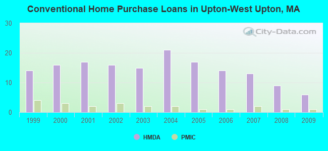
| Home Mortgage Disclosure Act Aggregated Statistics For Year 2009 (Based on 1 partial tract) | ||||||||
| A) FHA, FSA/RHS & VA Home Purchase Loans | B) Conventional Home Purchase Loans | C) Refinancings | D) Home Improvement Loans | |||||
|---|---|---|---|---|---|---|---|---|
| Number | Average Value | Number | Average Value | Number | Average Value | Number | Average Value | |
| LOANS ORIGINATED | 2 | $231,390 | 6 | $313,340 | 44 | $262,887 | 1 | $153,050 |
| APPLICATIONS APPROVED, NOT ACCEPTED | 0 | $0 | 0 | $0 | 2 | $227,175 | 0 | $0 |
| APPLICATIONS DENIED | 0 | $0 | 1 | $370,620 | 6 | $289,687 | 1 | $126,470 |
| APPLICATIONS WITHDRAWN | 0 | $0 | 1 | $242,400 | 6 | $243,607 | 0 | $0 |
| FILES CLOSED FOR INCOMPLETENESS | 0 | $0 | 0 | $0 | 2 | $289,005 | 0 | $0 |
Detailed HMDA statistics for the following Tracts: 7431.00
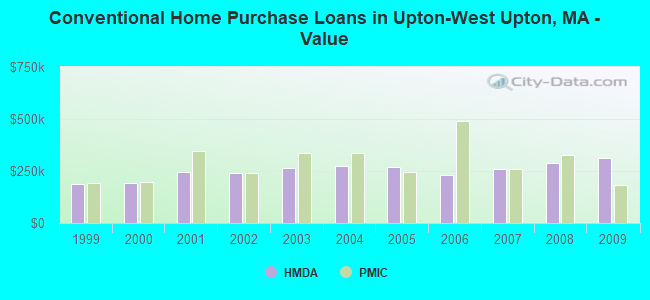
| Private Mortgage Insurance Companies Aggregated Statistics For Year 2009 (Based on 1 partial tract) | ||||
| A) Conventional Home Purchase Loans | B) Refinancings | |||
|---|---|---|---|---|
| Number | Average Value | Number | Average Value | |
| LOANS ORIGINATED | 1 | $182,910 | 1 | $189,120 |
| APPLICATIONS APPROVED, NOT ACCEPTED | 0 | $0 | 1 | $226,940 |
| APPLICATIONS DENIED | 0 | $0 | 0 | $0 |
| APPLICATIONS WITHDRAWN | 0 | $0 | 0 | $0 |
| FILES CLOSED FOR INCOMPLETENESS | 0 | $0 | 0 | $0 |
Detailed PMIC statistics for the following Tracts: 7431.00
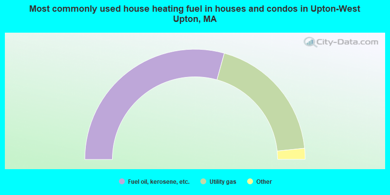
- 58.6%Fuel oil, kerosene, etc.
- 38.2%Utility gas
- 2.1%Electricity
- 1.1%Wood
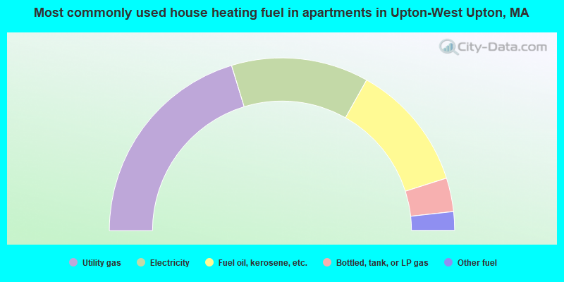
- 40.6%Utility gas
- 25.8%Electricity
- 23.9%Fuel oil, kerosene, etc.
- 6.3%Bottled, tank, or LP gas
- 3.5%Other fuel
Upton-West Upton compared to Massachusetts state average:
- Unemployed percentage significantly below state average.
- Black race population percentage significantly below state average.
- Hispanic race population percentage significantly below state average.
- Foreign-born population percentage significantly below state average.
- Renting percentage significantly below state average.
- Length of stay since moving in significantly above state average.
- Number of rooms per house significantly below state average.
- House age significantly below state average.
- Institutionalized population percentage significantly above state average.
- Number of college students below state average.