Sterling, Massachusetts


Submit your own pictures of this town and show them to the world
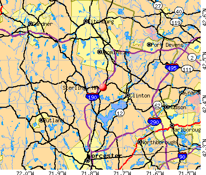
- OSM Map
- General Map
- Google Map
- MSN Map
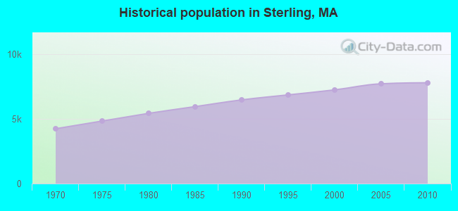
Population change since 2000: +7.6%
 |
| Males: 3,841 | |
| Females: 3,967 |
| Median resident age: | 44.0 years |
| Massachusetts median age: | 39.2 years |
Zip codes: 01564.
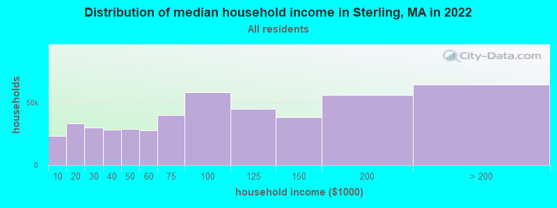
| Sterling: | $121,057 |
| MA: | $94,488 |
Estimated per capita income in 2022: $56,240 (it was $28,844 in 2000)
Sterling town income, earnings, and wages data
Estimated median house or condo value in 2022: $540,163 (it was $195,600 in 2000)
| Sterling: | $540,163 |
| MA: | $534,700 |
Mean prices in 2022: all housing units: $419,164; detached houses: $447,621; townhouses or other attached units: $343,592; in 2-unit structures: $323,295; in 3-to-4-unit structures: $332,295; in 5-or-more-unit structures: $232,758; mobile homes: $113,885
Detailed information about poverty and poor residents in Sterling, MA


- 7,44195.3%White alone
- 1582.0%Hispanic
- 670.9%Asian alone
- 670.9%Two or more races
- 520.7%Black alone
- 130.2%American Indian alone
- 50.06%Native Hawaiian and Other
Pacific Islander alone - 50.06%Other race alone
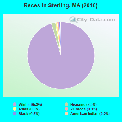
Races in Sterling detailed stats: ancestries, foreign born residents, place of birth
According to our research of Massachusetts and other state lists, there were 2 registered sex offenders living in Sterling, Massachusetts as of May 08, 2024.
The ratio of all residents to sex offenders in Sterling is 3,904 to 1.
The ratio of registered sex offenders to all residents in this city is much lower than the state average.
Type |
2009 |
2010 |
2011 |
2012 |
2013 |
2014 |
2015 |
2016 |
2017 |
2018 |
2019 |
2020 |
2021 |
2022 |
|---|---|---|---|---|---|---|---|---|---|---|---|---|---|---|
| Murders (per 100,000) | 0 (0.0) | 0 (0.0) | 0 (0.0) | 0 (0.0) | 0 (0.0) | 0 (0.0) | 0 (0.0) | 0 (0.0) | 0 (0.0) | 0 (0.0) | 0 (0.0) | 0 (0.0) | 0 (0.0) | 0 (0.0) |
| Rapes (per 100,000) | 3 (37.5) | 3 (38.4) | 1 (12.7) | 0 (0.0) | 3 (38.0) | 1 (12.6) | 1 (12.5) | 3 (37.5) | 2 (24.7) | 1 (12.2) | 3 (36.7) | 1 (12.2) | 2 (24.2) | 4 (47.8) |
| Robberies (per 100,000) | 0 (0.0) | 0 (0.0) | 0 (0.0) | 0 (0.0) | 1 (12.7) | 0 (0.0) | 0 (0.0) | 1 (12.5) | 0 (0.0) | 0 (0.0) | 0 (0.0) | 0 (0.0) | 3 (36.3) | 0 (0.0) |
| Assaults (per 100,000) | 4 (49.9) | 8 (102.5) | 4 (50.9) | 14 (177.1) | 8 (101.3) | 4 (50.4) | 3 (37.6) | 7 (87.6) | 7 (86.4) | 7 (85.6) | 1 (12.2) | 4 (48.9) | 2 (24.2) | 4 (47.8) |
| Burglaries (per 100,000) | 48 (599.3) | 44 (563.5) | 40 (509.2) | 31 (392.2) | 21 (266.0) | 32 (403.2) | 11 (138.0) | 19 (237.7) | 12 (148.1) | 9 (110.0) | 2 (24.5) | 5 (61.2) | 4 (48.4) | 7 (83.6) |
| Thefts (per 100,000) | 38 (474.5) | 41 (525.1) | 39 (496.4) | 56 (708.5) | 48 (608.0) | 52 (655.2) | 31 (388.8) | 33 (412.9) | 60 (740.6) | 21 (256.7) | 13 (159.0) | 23 (281.4) | 15 (181.4) | 16 (191.1) |
| Auto thefts (per 100,000) | 5 (62.4) | 4 (51.2) | 5 (63.6) | 2 (25.3) | 3 (38.0) | 0 (0.0) | 3 (37.6) | 2 (25.0) | 7 (86.4) | 2 (24.4) | 1 (12.2) | 2 (24.5) | 3 (36.3) | 1 (11.9) |
| Arson (per 100,000) | 3 (37.5) | 2 (25.6) | 1 (12.7) | 1 (12.7) | 0 (0.0) | 0 (0.0) | 1 (12.5) | 1 (12.5) | 2 (24.7) | 0 (0.0) | 0 (0.0) | 1 (12.2) | 0 (0.0) | 1 (11.9) |
| City-Data.com crime index | 105.9 | 115.8 | 81.0 | 93.2 | 100.4 | 74.6 | 45.8 | 86.5 | 83.9 | 46.8 | 40.9 | 37.1 | 48.6 | 62.2 |
The City-Data.com crime index weighs serious crimes and violent crimes more heavily. Higher means more crime, U.S. average is 246.1. It adjusts for the number of visitors and daily workers commuting into cities.
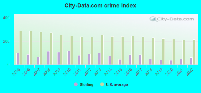
Crime rate in Sterling detailed stats: murders, rapes, robberies, assaults, burglaries, thefts, arson
Full-time law enforcement employees in 2021, including police officers: 20 (14 officers - 13 male; 1 female).
| Officers per 1,000 residents here: | 1.69 |
| Massachusetts average: | 2.53 |
 Recent articles from our blog. Our writers, many of them Ph.D. graduates or candidates, create easy-to-read articles on a wide variety of topics.


 | Buying a house in Sterling, MA (51 replies) |
| 2023 Real Estate Observations (5278 replies) |
| Another shooting in New Bedford (69 replies) |
| Moving to MA from out of state - figuring out how to pick the "right" suburb for me and my family (81 replies) |
| Best of Boston Food Thread - Summer of 2023 (13 replies) |
| Work in Sterling, where to live (family of 4)? (5 replies) |
Latest news from Sterling, MA collected exclusively by city-data.com from local newspapers, TV, and radio stations
Sterling, MA City Guides:
Ancestries: Irish (25.3%), Italian (20.3%), French (15.8%), English (13.8%), German (11.2%), French Canadian (8.0%).
Current Local Time: EST time zone
Incorporated in 1781
Elevation: 502 feet
Land area: 30.5 square miles.
Population density: 256 people per square mile (very low).
130 residents are foreign born
| This town: | 1.8% |
| Massachusetts: | 12.2% |
| Sterling town: | 1.2% ($2,419) |
| Massachusetts: | 1.3% ($2,336) |
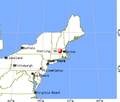
Nearest city with pop. 50,000+: Worcester, MA  (11.7 miles , pop. 172,648).
Nearest city with pop. 200,000+: Boston, MA (35.9 miles , pop. 589,141).
Nearest city with pop. 1,000,000+: Bronx, NY (154.5 miles , pop. 1,332,650).
Nearest cities:
), ), ), Latitude: 42.44 N, Longitude: 71.77 W
Area code: 978

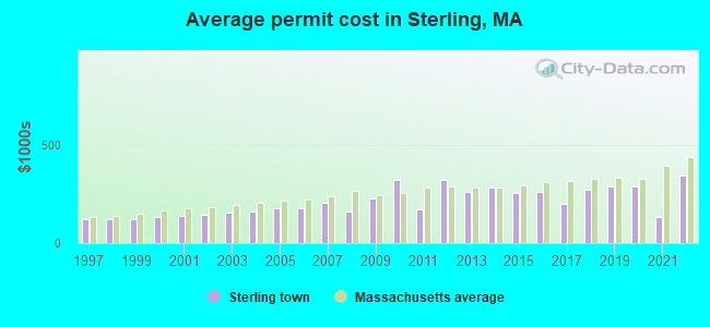
Single-family new house construction building permits:
- 2022: 22 buildings, average cost: $340,900
- 2021: 1 building, cost: $130,000
- 2020: 16 buildings, average cost: $285,700
- 2019: 16 buildings, average cost: $285,700
- 2018: 12 buildings, average cost: $269,300
- 2017: 20 buildings, average cost: $200,000
- 2016: 29 buildings, average cost: $261,800
- 2015: 29 buildings, average cost: $257,200
- 2014: 17 buildings, average cost: $283,000
- 2013: 11 buildings, average cost: $258,600
- 2012: 7 buildings, average cost: $321,400
- 2011: 8 buildings, average cost: $170,600
- 2010: 7 buildings, average cost: $319,400
- 2009: 6 buildings, average cost: $225,300
- 2008: 8 buildings, average cost: $160,600
- 2007: 13 buildings, average cost: $203,800
- 2006: 48 buildings, average cost: $177,500
- 2005: 54 buildings, average cost: $177,500
- 2004: 29 buildings, average cost: $162,100
- 2003: 39 buildings, average cost: $152,700
- 2002: 48 buildings, average cost: $144,700
- 2001: 45 buildings, average cost: $138,200
- 2000: 42 buildings, average cost: $130,000
- 1999: 54 buildings, average cost: $121,700
- 1998: 65 buildings, average cost: $118,900
- 1997: 73 buildings, average cost: $120,600

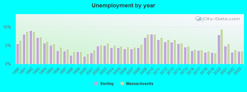
| Here: | 3.4% |
| Massachusetts: | 3.5% |
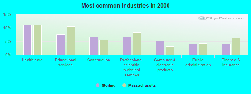
- Health care (11.1%)
- Educational services (7.6%)
- Construction (6.8%)
- Professional, scientific, technical services (6.8%)
- Computer & electronic products (5.2%)
- Public administration (4.0%)
- Finance & insurance (3.9%)
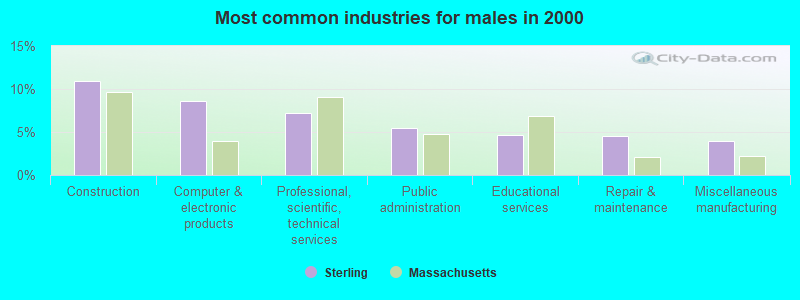
- Construction (11.0%)
- Computer & electronic products (8.6%)
- Professional, scientific, technical services (7.2%)
- Public administration (5.4%)
- Educational services (4.6%)
- Repair & maintenance (4.6%)
- Miscellaneous manufacturing (3.9%)
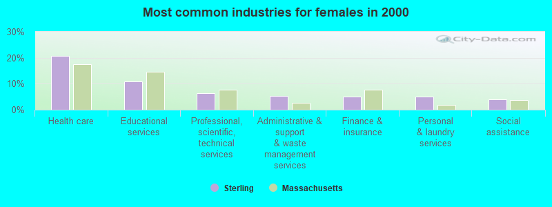
- Health care (20.7%)
- Educational services (11.0%)
- Professional, scientific, technical services (6.3%)
- Administrative & support & waste management services (5.3%)
- Finance & insurance (5.1%)
- Personal & laundry services (5.0%)
- Social assistance (4.0%)
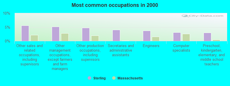
- Other sales and related occupations, including supervisors (5.6%)
- Other management occupations, except farmers and farm managers (5.1%)
- Other production occupations, including supervisors (4.8%)
- Secretaries and administrative assistants (4.0%)
- Engineers (3.7%)
- Computer specialists (3.1%)
- Preschool, kindergarten, elementary, and middle school teachers (3.0%)

- Other production occupations, including supervisors (6.8%)
- Engineers (6.6%)
- Other sales and related occupations, including supervisors (5.5%)
- Other management occupations, except farmers and farm managers (5.3%)
- Computer specialists (4.5%)
- Driver/sales workers and truck drivers (4.1%)
- Top executives (4.0%)

- Secretaries and administrative assistants (8.6%)
- Other sales and related occupations, including supervisors (5.7%)
- Preschool, kindergarten, elementary, and middle school teachers (4.9%)
- Other management occupations, except farmers and farm managers (4.9%)
- Registered nurses (4.8%)
- Health technologists and technicians (4.0%)
- Other office and administrative support workers, including supervisors (3.9%)
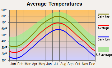
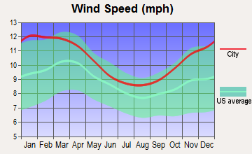
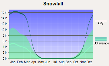
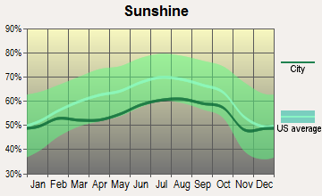
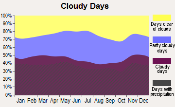
Average climate in Sterling, Massachusetts
Based on data reported by over 4,000 weather stations
(lower is better)
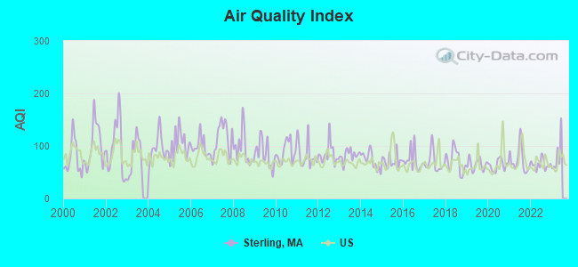
Air Quality Index (AQI) level in 2022 was 64.6. This is about average.
| City: | 64.6 |
| U.S.: | 72.6 |
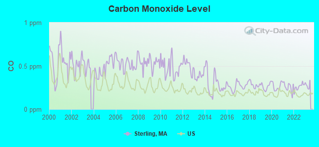
Carbon Monoxide (CO) [ppm] level in 2022 was 0.259. This is about average. Closest monitor was 11.8 miles away from the city center.
| City: | 0.259 |
| U.S.: | 0.251 |
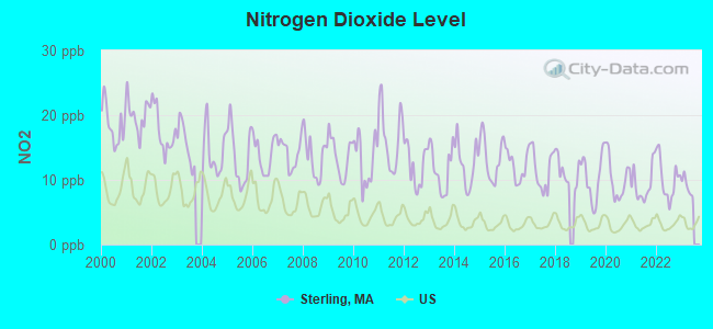
Nitrogen Dioxide (NO2) [ppb] level in 2022 was 10.1. This is significantly worse than average. Closest monitor was 9.3 miles away from the city center.
| City: | 10.1 |
| U.S.: | 5.1 |
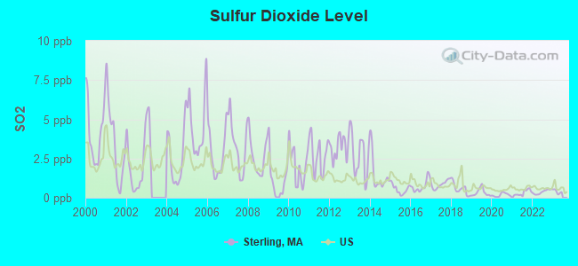
Sulfur Dioxide (SO2) [ppb] level in 2022 was 0.370. This is significantly better than average. Closest monitor was 6.2 miles away from the city center.
| City: | 0.370 |
| U.S.: | 1.515 |
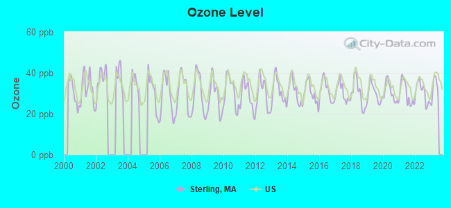
Ozone [ppb] level in 2022 was 30.3. This is about average. Closest monitor was 9.3 miles away from the city center.
| City: | 30.3 |
| U.S.: | 33.3 |
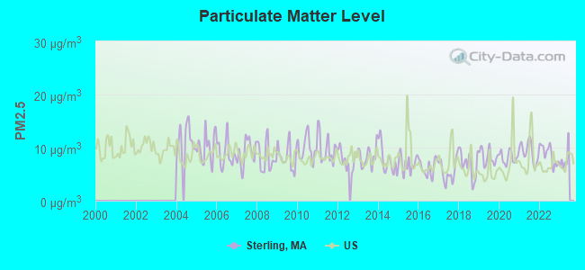
Particulate Matter (PM2.5) [µg/m3] level in 2022 was 8.71. This is about average. Closest monitor was 11.0 miles away from the city center.
| City: | 8.71 |
| U.S.: | 8.11 |
Tornado activity:
Sterling-area historical tornado activity is slightly above Massachusetts state average. It is 19% smaller than the overall U.S. average.
On 6/9/1953, a category F4 (max. wind speeds 207-260 mph) tornado 16.0 miles away from the Sterling town center killed 90 people and injured 1228 people and caused between $50,000,000 and $500,000,000 in damages.
On 6/22/1981, a category F3 (max. wind speeds 158-206 mph) tornado 10.1 miles away from the town center injured 3 people and caused between $5000 and $50,000 in damages.
Earthquake activity:
Sterling-area historical earthquake activity is significantly above Massachusetts state average. It is 71% smaller than the overall U.S. average.On 10/7/1983 at 10:18:46, a magnitude 5.3 (5.1 MB, 5.3 LG, 5.1 ML, Class: Moderate, Intensity: VI - VII) earthquake occurred 166.6 miles away from Sterling center
On 4/20/2002 at 10:50:47, a magnitude 5.3 (5.3 ML, Depth: 3.0 mi) earthquake occurred 173.0 miles away from the city center
On 4/20/2002 at 10:50:47, a magnitude 5.2 (5.2 MB, 4.2 MS, 5.2 MW, 5.0 MW) earthquake occurred 172.1 miles away from Sterling center
On 1/19/1982 at 00:14:42, a magnitude 4.7 (4.5 MB, 4.7 MD, 4.5 LG, Class: Light, Intensity: IV - V) earthquake occurred 74.1 miles away from the city center
On 10/16/2012 at 23:12:25, a magnitude 4.7 (4.7 ML, Depth: 10.0 mi) earthquake occurred 98.2 miles away from Sterling center
On 8/22/1992 at 12:20:32, a magnitude 4.8 (4.8 MB, 3.8 MS, 4.7 LG, Depth: 6.2 mi) earthquake occurred 242.6 miles away from the city center
Magnitude types: regional Lg-wave magnitude (LG), body-wave magnitude (MB), duration magnitude (MD), local magnitude (ML), surface-wave magnitude (MS), moment magnitude (MW)
Natural disasters:
The number of natural disasters in Worcester County (27) is a lot greater than the US average (15).Major Disasters (Presidential) Declared: 15
Emergencies Declared: 12
Causes of natural disasters: Floods: 9, Storms: 8, Hurricanes: 6, Snowstorms: 5, Winter Storms: 4, Blizzards: 2, Snows: 2, Fire: 1, Heavy Rain: 1, Snowfall: 1, Tornado: 1, Wind: 1 (Note: some incidents may be assigned to more than one category).
Hospitals and medical centers in Sterling:
Other hospitals and medical centers near Sterling:
- OAKDALE NURSING HOME (Nursing Home, about 4 miles away; WEST BOYLSTON, MA)
- OAKDALE REHABILITATION AND SKILLED NURSING CENTER (Nursing Home, about 4 miles away; WEST BOYLSTON, MA)
- CLINTON HOSPITAL ASSOCIATION Acute Care Hospitals (about 5 miles away; CLINTON, MA)
- CLINTON MANOR NURSING HOME (Nursing Home, about 5 miles away; CLINTON, MA)
- KINDRED NURSING AND REHABILITATION-RIVER TERRACE (Nursing Home, about 6 miles away; LANCASTER, MA)
- PRESENTATION HEALTH CARE CENTER (Nursing Home, about 7 miles away; LEOMINSTER, MA)
- FAIRLAWN N H (Nursing Home, about 7 miles away; LEOMINSTER, MA)
Airports located in Sterling:
- Sterling Airport (3B3) (Runways: 2, Air Taxi Ops: 20, Itinerant Ops: 14,000, Local Ops: 35,200, Military Ops: 35)
Amtrak station near Sterling:
Colleges/universities with over 2000 students nearest to Sterling:
- Quinsigamond Community College (about 9 miles; Worcester, MA; Full-time enrollment: 5,877)
- Assumption College (about 11 miles; Worcester, MA; FT enrollment: 2,580)
- Fitchburg State University (about 11 miles; Fitchburg, MA; FT enrollment: 5,010)
- Worcester Polytechnic Institute (about 12 miles; Worcester, MA; FT enrollment: 3,930)
- Worcester State University (about 13 miles; Worcester, MA; FT enrollment: 5,426)
- Clark University (about 14 miles; Worcester, MA; FT enrollment: 3,687)
- College of the Holy Cross (about 14 miles; Worcester, MA; FT enrollment: 3,125)
Public elementary/middle schools in Sterling:
- HOUGHTON ELEMENTARY (Students: 503, Location: 32 BOUTELLE ROAD, Grades: KG-4)
- CHOCKSETT MIDDLE SCHOOL (Students: 425, Location: 40 BOUTELLE ROAD, Grades: 5-8)
Library in Sterling:
Points of interest:
Notable locations in Sterling: Clearview Farm (A), Meadowbrook Orchards (B), Old Oak Apple Farm (C), Sunny Crest Orchards (D), Sterling Fire Department (E), Sterling Town Hall (F). Display/hide their locations on the map
Churches in Sterling include: Saint Richards Church (A), Rock Church (B), First Church in Sterling (C). Display/hide their locations on the map
Cemeteries: Hillside Cemetery (1), Chocksett Cemetery (2), Hillside Cemetery (3), Oak Hill Cemetery (4), West Cemetery (5), Oak Hill Cemetery (6). Display/hide their locations on the map
Lakes and reservoirs: West Waushacum Pond (A), Tuttle Lake (B), Spring Basin (C), The Quag (D), Muddy Pond (E), Lynde Basins (F), Fitch Pond (G), East Waushacum Pond (H). Display/hide their locations on the map
Streams, rivers, and creeks: Ball Brook (A), Bartlett Pond Brook (B), Connelly Brook (C), East Wachusett Brook (D), Houghton Brook (E), Justice Brook (F), Keyes Brook (G), Lynde Brook (H), Rocky Brook (I). Display/hide their locations on the map
Parks in Sterling include: Sholan Park (1), Sterling Center Historic District (2). Display/hide their locations on the map
Beach: Sterling Town Beach (A). Display/hide its location on the map
Tourist attraction: Davis' Mega Maze (Tours & Charters; 145 Redstone Hill Road) (1). Display/hide its approximate location on the map
Birthplace of: Jay Cutler (bodybuilder) - Bodybuilder, Prentiss Mellen - Judge, Nathaniel Wright - Politician, Patrick Tatten - Film actor.
Drinking water stations with addresses in Sterling and their reported violations in the past:
STERLING WATER DEPARTMENT (Population served: 6,288, Groundwater):Past health violations:Past monitoring violations:
- MCL, Monthly (TCR) - In JUL-2010, Contaminant: Coliform. Follow-up actions: St Boil Water Order (JUL-21-2010), St Compliance achieved (SEP-20-2010), St AO (w/o penalty) issued (SEP-20-2010)
- MCL, Average - Between JUL-2008 and SEP-2008, Contaminant: Perchlorate. Follow-up actions: St AO (w/o penalty) issued (NOV-18-2008)
- MCL, Monthly (TCR) - In AUG-2006, Contaminant: Coliform. Follow-up actions: St AO (w/o penalty) issued (OCT-10-2006)
- MCL, Monthly (TCR) - In JUL-2006, Contaminant: Coliform. Follow-up actions: St AO (w/o penalty) issued (OCT-10-2006)
- Monitoring and Reporting (DBP) - Between APR-2014 and JUN-2014, Contaminant: Chlorine. Follow-up actions: St AO (w/o penalty) issued (SEP-10-2014)
- Follow-up Or Routine LCR Tap M/R - In JUL-01-2009, Contaminant: Lead and Copper Rule. Follow-up actions: St AO (w/o penalty) issued (MAR-01-2010), St Compliance achieved (JUN-05-2012)
- 5 minor monitoring violations
- 24 regular monitoring violations
| This town: | 2.7 people |
| Massachusetts: | 2.5 people |
| This town: | 77.2% |
| Whole state: | 63.0% |
| This town: | 4.7% |
| Whole state: | 7.0% |
Likely homosexual households (counted as self-reported same-sex unmarried-partner households)
- Lesbian couples: 0.4% of all households
- Gay men: 0.0% of all households
| This town: | 2.9% |
| Whole state: | 9.3% |
| This town: | 0.6% |
| Whole state: | 4.4% |
4 people in group homes intended for adults in 2010
Banks with branches in Sterling (2011 data):
- Sovereign Bank, National Association: Sterling Branch at 37 Main Street, branch established on 1972/08/26. Info updated 2012/01/31: Bank assets: $78,146.9 mil, Deposits: $48,042.9 mil, headquarters in Wilmington, DE, positive income, Commercial Lending Specialization, 718 total offices, Holding Company: Banco Santander, S.A.
- Clinton Savings Bank: Sterling Branch at One Main Street, branch established on 1979/05/07. Info updated 2012/04/03: Bank assets: $479.5 mil, Deposits: $362.7 mil, headquarters in Clinton, MA, positive income, Mortgage Lending Specialization, 7 total offices, Holding Company: Clinton Financial Services, Mhc
For population 15 years and over in Sterling:
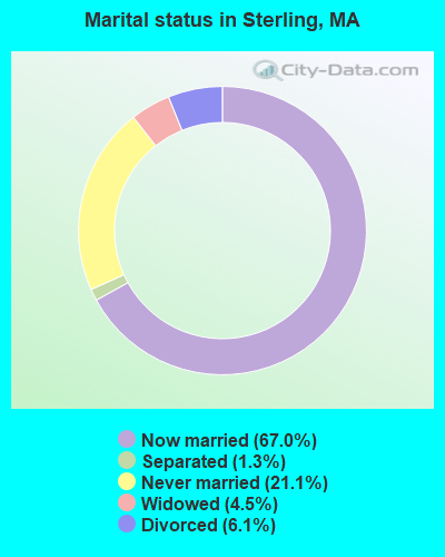
- Never married: 21.1%
- Now married: 67.0%
- Separated: 1.3%
- Widowed: 4.5%
- Divorced: 6.1%
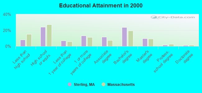
For population 25 years and over in Sterling:
- High school or higher: 91.7%
- Bachelor's degree or higher: 35.9%
- Graduate or professional degree: 12.2%
- Unemployed: 1.7%
- Mean travel time to work (commute): 28.8 minutes
| Here: | 10.1 |
| Massachusetts average: | 13.1 |


Graphs represent county-level data. Detailed 2008 Election Results
Religion statistics for Sterling, MA (based on Worcester County data)


| Religion | Adherents | Congregations |
|---|---|---|
| Catholic | 306,925 | 118 |
| Mainline Protestant | 43,326 | 171 |
| Evangelical Protestant | 37,511 | 203 |
| Other | 18,931 | 69 |
| Orthodox | 7,935 | 15 |
| Black Protestant | 497 | 6 |
| None | 383,427 | - |
Food Environment Statistics:
| This county: | 1.73 / 10,000 pop. |
| Massachusetts: | 1.98 / 10,000 pop. |
| Worcester County: | 0.05 / 10,000 pop. |
| State: | 0.05 / 10,000 pop. |
| This county: | 1.79 / 10,000 pop. |
| Massachusetts: | 2.22 / 10,000 pop. |
| Worcester County: | 2.22 / 10,000 pop. |
| Massachusetts: | 1.77 / 10,000 pop. |
| This county: | 7.27 / 10,000 pop. |
| Massachusetts: | 8.76 / 10,000 pop. |
| This county: | 8.0% |
| Massachusetts: | 8.1% |
| Here: | 24.0% |
| Massachusetts: | 22.5% |
| Worcester County: | 16.6% |
| State: | 16.5% |
4.71% of this county's 2021 resident taxpayers lived in other counties in 2020 ($76,229 average adjusted gross income)
| Here: | 4.71% |
| Massachusetts average: | 6.35% |
0.02% of residents moved from foreign countries ($100 average AGI)
Worcester County: 0.02% Massachusetts average: 0.01%
Top counties from which taxpayers relocated into this county between 2020 and 2021:
| from Middlesex County, MA | |
| from Norfolk County, MA | |
| from Suffolk County, MA |
4.84% of this county's 2020 resident taxpayers moved to other counties in 2021 ($87,252 average adjusted gross income)
| Here: | 4.84% |
| Massachusetts average: | 7.18% |
0.03% of residents moved to foreign countries ($199 average AGI)
Worcester County: 0.03% Massachusetts average: 0.02%
Top counties to which taxpayers relocated from this county between 2020 and 2021:
| to Middlesex County, MA | |
| to Norfolk County, MA | |
| to Suffolk County, MA |
| Businesses in Sterling, MA | ||||
| Name | Count | Name | Count | |
|---|---|---|---|---|
| Dunkin Donuts | 1 | True Value | 1 | |
| FedEx | 1 | UPS | 1 | |
| MasterBrand Cabinets | 5 | |||
Strongest AM radio stations in Sterling:
- WCRN (830 AM; 50 kW; WORCESTER, MA; Owner: CARTER BROADCASTING CORPORATION)
- WTAG (580 AM; 5 kW; WORCESTER, MA; Owner: CAPSTAR TX LIMITED PARTNERSHIP)
- WKOX (1200 AM; 50 kW; FRAMINGHAM, MA; Owner: CAPSTAR TX LIMITED PARTNERSHIP)
- WBIX (1060 AM; 40 kW; NATICK, MA; Owner: LANGER BROADCASTING CORPORATION)
- WRKO (680 AM; 50 kW; BOSTON, MA; Owner: ENTERCOM BOSTON LICENSE, LLC)
- WVNE (760 AM; daytime; 25 kW; LEICESTER, MA; Owner: BLOUNT MASSCOM, INC.)
- WEEI (850 AM; 50 kW; BOSTON, MA; Owner: ENTERCOM BOSTON LICENSE, LLC)
- WAMG (890 AM; 25 kW; DEDHAM, MA; Owner: MEGA COMMUNICATIONS OF DEDHAM LICENSEE, LLC)
- WAZN (1470 AM; 7 kW; MARLBOROUGH, MA; Owner: MULTICULTURAL RADIO BROADCASTING, INC.)
- WALE (990 AM; 50 kW; GREENVILLE, RI; Owner: NORTH AMERICAN BROADCASTING CO., INC.)
- WWZN (1510 AM; 50 kW; BOSTON, MA; Owner: ROSE CITY RADIO CORPORATION)
- WEIM (1280 AM; 5 kW; FITCHBURG, MA; Owner: LIVEAIR COMMUNICATIONS, INC.)
- WVEI (1440 AM; 5 kW; WORCESTER, MA; Owner: ENTERCOM BOSTON LICENSE, LLC)
Strongest FM radio stations in Sterling:
- WXLO (104.5 FM; FITCHBURG, MA; Owner: CITADEL BROADCASTING COMPANY)
- WAAF (107.3 FM; WORCESTER, MA; Owner: ENTERCOM BOSTON LICENSE, LLC)
- WSRS (96.1 FM; WORCESTER, MA; Owner: CAPSTAR TX LIMITED PARTNERSHIP)
- WFEX (92.1 FM; PETERBOROUGH, NH; Owner: FNX BROADCASTING OF NEW HAMPSHIRE LLC)
- WICN (90.5 FM; WORCESTER, MA; Owner: WICN PUBLIC RADIO, INC)
- WBMX (98.5 FM; BOSTON, MA; Owner: INFINITY RADIO OPERATIONS INC.)
- WJMN (94.5 FM; BOSTON, MA; Owner: AMFM RADIO LICENSES, L.L.C.)
- WCRB (102.5 FM; WALTHAM, MA; Owner: CHARLES RIVER BROADCASTING WCRB LICE)
- WTKK (96.9 FM; BOSTON, MA; Owner: GREATER BOSTON RADIO, INC.)
- WROR-FM (105.7 FM; FRAMINGHAM, MA; Owner: GREATER BOSTON RADIO, INC.)
- WBOS (92.9 FM; BROOKLINE, MA; Owner: GREATER BOSTON RADIO, INC.)
- WGBH (89.7 FM; BOSTON, MA; Owner: WGBH EDUCATIONAL FOUNDATION)
- WBUR-FM (90.9 FM; BOSTON, MA; Owner: TRUSTEES OF BOSTON UNIVERSITY)
- WXKS-FM (107.9 FM; MEDFORD, MA; Owner: AMFM RADIO LICENSES, L.L.C.)
- WMJX (106.7 FM; BOSTON, MA; Owner: GREATER BOSTON RADIO, INC.)
- WODS (103.3 FM; BOSTON, MA; Owner: INFINITY BROADCASTING OPERATIONS, INC.)
- WFCR (88.5 FM; AMHERST, MA; Owner: UNIVERSITY OF MASSACHUSETTS)
- WGIR-FM (101.1 FM; MANCHESTER, NH; Owner: CAPSTAR TX LIMITED PARTNERSHIP)
- WBPR (91.9 FM; WORCESTER, MA; Owner: UNIVERSITY OF MASSACHUSETTS)
- WAHL (99.9 FM; ATHOL, MA; Owner: CITADEL BROADCASTING COMPANY)
TV broadcast stations around Sterling:
- WUNI (Channel 27; WORCESTER, MA; Owner: ENTRAVISION HOLDINGS, LLC)
- WUTF (Channel 66; MARLBOROUGH, MA; Owner: TELEFUTURA BOSTON LLC)
- WCVB-TV (Channel 5; BOSTON, MA; Owner: WCVB HEARST-ARGYLE TV, INC.)
- WGBH-TV (Channel 2; BOSTON, MA; Owner: WGBH EDUCATIONAL FOUNDATION)
- WHDH-TV (Channel 7; BOSTON, MA; Owner: WHDH-TV)
- WMFP (Channel 62; LAWRENCE, MA; Owner: WSAH LICENSE, INC.)
- WBZ-TV (Channel 4; BOSTON, MA; Owner: VIACOM INC.)
- WGBX-TV (Channel 44; BOSTON, MA; Owner: WGBH EDUCATIONAL FOUNDATION)
- WSBK-TV (Channel 38; BOSTON, MA; Owner: VIACOM INC.)
- WLVI-TV (Channel 56; CAMBRIDGE, MA; Owner: WLVI, INC.)
- WFXT (Channel 25; BOSTON, MA; Owner: FOX TELEVISION STATIONS INC.)
- WYDN (Channel 48; WORCESTER, MA; Owner: EDUCATIONAL PUBLIC TV CORPORATION)
- W40BO (Channel 40; BOSTON, MA; Owner: PAXSON COMMUNICATIONS LPTV, INC.)
- WBPX (Channel 68; BOSTON, MA; Owner: PAXSON BOSTON-68 LICENSE, INC.)
- WCRN-LP (Channel 34; LEICESTER, MA; Owner: CARTER BROADCASTING CORPORATION)
- WFXZ-CA (Channel 24; BOSTON, MA; Owner: BOSTON BROADCASTING CORP.)
- WTMU-LP (Channel 32; BOSTON, MA; Owner: ZGS BOSTON, INC.)
- WCEA-LP (Channel 58; BOSTON, MA; Owner: CHANNEL 19 TV CORPORATION)
- WNDS (Channel 50; DERRY, NH; Owner: CTV OF DERRY, INC)

- National Bridge Inventory (NBI) Statistics
- 31Number of bridges
- 331ft / 101mTotal length
- $38,798,000Total costs
- 492,806Total average daily traffic
- 45,981Total average daily truck traffic
- 653,107Total future (year 2031) average daily traffic

- New bridges - historical statistics
- 11910-1919
- 11940-1949
- 201970-1979
- 51980-1989
- 11990-1999
- 22000-2009
- 12010-2019
FCC Registered Antenna Towers:
27 (See the full list of FCC Registered Antenna Towers in Sterling)FCC Registered Broadcast Land Mobile Towers:
10 (See the full list of FCC Registered Broadcast Land Mobile Towers in Sterling, MA)FCC Registered Microwave Towers:
4- STERLING, Chocksett Road (Lat: 42.450139 Lon: -71.745167), Type: Mast, Structure height: 57.9 m, Overall height: 58.5 m, Call Sign: WPNG946,
Assigned Frequencies: 10652.5 MHz, 10621.2 MHz, Grant Date: 03/02/2010, Expiration Date: 04/01/2020, Cancellation Date: 09/08/2016, Certifier: Carol L Tacker, Registrant: At&t Mobility LLC, 1120 20th Street, Nw - Suite 1000, Washington, DC 20036, Phone: (202) 457-2055, Fax: (202) 457-3073, Email:
- Sterling, 9 Chocksett Road (Lat: 42.450139 Lon: -71.745139), Type: Mast, Structure height: 59.4 m, Call Sign: WQEK890,
Assigned Frequencies: 10647.5 MHz, Grant Date: 02/24/2006, Expiration Date: 02/24/2016, Cancellation Date: 02/18/2014, Certifier: Richard A Craig, Registrant: Verizon Wireless, 1120 Sanctuary Pkwy, #150 Gasa5reg, Alpharetta, GA 30009-7630, Phone: (770) 797-1070, Fax: (770) 797-1036, Email:
- BOS1135, 3 Redemption Rock Trail (Lat: 42.402444 Lon: -71.794000), Type: Tower, Structure height: 54.8 m, Call Sign: WQIS251, Licensee ID: L01728370,
Assigned Frequencies: 11285.0 MHz, Grant Date: 04/29/2008, Expiration Date: 04/29/2018, Cancellation Date: 09/09/2013, Certifier: Joseph M Sandri Jr., Registrant: Fibertower Network Services, Corp., Debtor-In-Possession, 1875 Eye Street, Nw, 5th Floor, Room 505, Washington, DC 20006, Phone: (202) 223-1028, Email:
- BS33XC068, 11 Chocksett St. (Lat: 42.450083 Lon: -71.745222), Type: Ltower, Structure height: 54.9 m, Call Sign: WQPU716,
Assigned Frequencies: 11545.0 MHz, 11545.0 MHz, 11545.0 MHz, Grant Date: 08/20/2012, Expiration Date: 08/20/2022, Cancellation Date: 04/06/2022, Certifier: David Werblow, Registrant: Dla Piper LLP, 500 8th Street, Nw, Washington, DC 20004, Phone: (202) 799-4216, Fax: (202) 799-5616, Email:
FCC Registered Maritime Coast & Aviation Ground Towers:
1- Sterling Airport (Lat: 42.430917 Lon: -71.795917), Type: Building, Overall height: 5 m, Call Sign: WRK4,
Assigned Frequencies: 122.900 MHz, Grant Date: 08/04/1999, Expiration Date: 07/26/2004, Cancellation Date: 09/26/2004, Registrant: Sterling Air Inc, 121 Greenland Rd, Sterling, MA 01564
FCC Registered Amateur Radio Licenses:
37 (See the full list of FCC Registered Amateur Radio Licenses in Sterling)FAA Registered Aircraft:
24 (See the full list of FAA Registered Aircraft in Sterling)2002 - 2018 National Fire Incident Reporting System (NFIRS) incidents
- Fire incident types reported to NFIRS in Sterling, MA
- 26440.7%Structure Fires
- 21433.0%Outside Fires
- 11217.3%Mobile Property/Vehicle Fires
- 599.1%Other
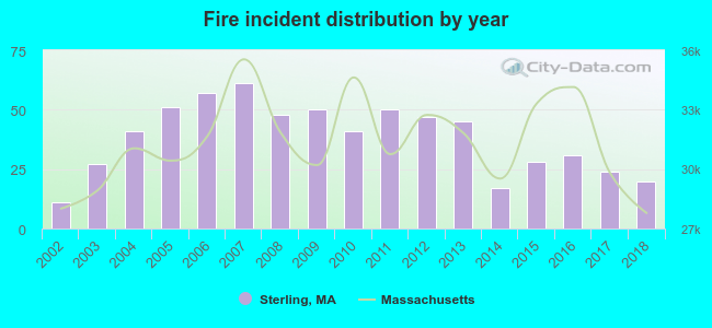 According to the data from the years 2002 - 2018 the average number of fires per year is 38. The highest number of reported fires - 61 took place in 2007, and the least - 11 in 2002. The data has a growing trend.
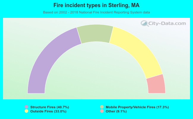 When looking into fire subcategories, the most incidents belonged to: Structure Fires (40.7%), and Outside Fires (33.0%).
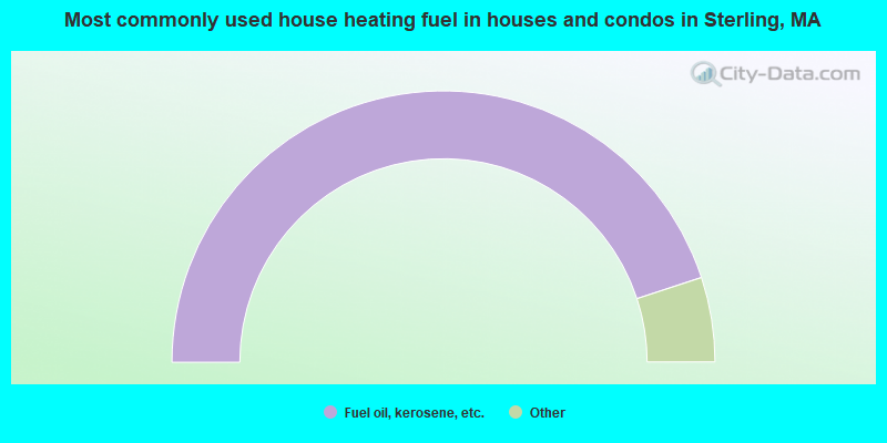
- 89.9%Fuel oil, kerosene, etc.
- 3.2%Electricity
- 3.0%Bottled, tank, or LP gas
- 2.6%Wood
- 0.6%Solar energy
- 0.5%Utility gas
- 0.3%Coal or coke
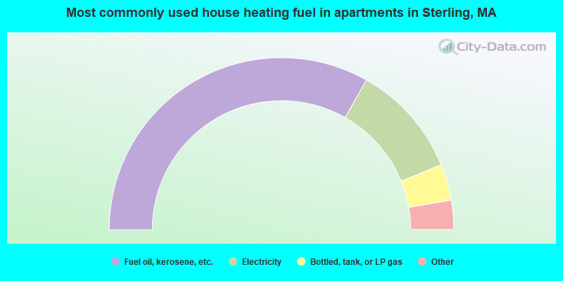
- 66.5%Fuel oil, kerosene, etc.
- 21.3%Electricity
- 6.8%Bottled, tank, or LP gas
- 2.9%Other fuel
- 2.6%Wood
Sterling compared to Massachusetts state average:
- Unemployed percentage significantly below state average.
- Black race population percentage significantly below state average.
- Hispanic race population percentage significantly below state average.
- Median age above state average.
- Foreign-born population percentage significantly below state average.
- Renting percentage significantly below state average.
- Length of stay since moving in significantly above state average.
- Number of rooms per house significantly below state average.
- House age significantly below state average.
- Number of college students below state average.
Sterling on our top lists:
- #13 on the list of "Top 101 cities with largest percentage of females in industries: personal and laundry services (population 5,000+)"
- #18 on the list of "Top 101 cities with largest percentage of females in occupations: financial managers (population 5,000+)"
- #23 on the list of "Top 101 cities with largest percentage of females in industries: nonmetallic mineral products (population 5,000+)"
- #31 on the list of "Top 101 cities with largest percentage of females in industries: plastics and rubber products (population 5,000+)"
- #32 on the list of "Top 101 cities with largest percentage of males in industries: nonmetallic mineral products (population 5,000+)"
- #36 on the list of "Top 101 cities with largest percentage of females in industries: repair and maintenance (population 5,000+)"
- #43 on the list of "Top 101 cities with largest percentage of females in occupations: therapists (population 5,000+)"
- #48 on the list of "Top 101 cities with largest percentage of males in industries: miscellaneous manufacturing (population 5,000+)"
- #51 on the list of "Top 101 cities with largest percentage of males in industries: computer and electronic products (population 5,000+)"
- #53 on the list of "Top 101 cities with largest percentage of males in occupations: mathematical science occupations (population 5,000+)"
- #55 on the list of "Top 101 cities with largest percentage of females in occupations: motor vehicle operators except bus and truck drivers (population 5,000+)"
- #58 on the list of "Top 101 cities with largest percentage of males in occupations: engineers (population 5,000+)"
- #61 on the list of "Top 101 cities with largest percentage of females in occupations: operations specialties managers except financial managers (population 5,000+)"
- #61 on the list of "Top 101 cities with largest percentage of females in industries: machinery, equipment, and supplies merchant wholesalers (population 5,000+)"
- #70 on the list of "Top 101 cities with largest percentage of males in industries: printing and related support activities (population 5,000+)"
- #74 on the list of "Top 101 cities with largest percentage of males in industries: book stores and news dealers (population 5,000+)"
- #75 on the list of "Top 101 cities with largest percentage of males in industries: electrical and electronic goods merchant wholesalers (population 5,000+)"
- #60 (01564) on the list of "Top 101 zip codes with the largest percentage of Scottish first ancestries (pop 5,000+)"
- #4 on the list of "Top 101 counties with the highest carbon monoxide air pollution readings in 2012 (ppm)"
- #5 on the list of "Top 101 counties with the most Catholic congregations"
- #12 on the list of "Top 101 counties with the highest surface withdrawal of fresh water for public supply"
- #16 on the list of "Top 101 counties with the highest total withdrawal of fresh water for public supply"
- #23 on the list of "Top 101 counties with the highest Sulfur Oxides Annual air pollution readings in 2012 (µg/m3)"

|
|
Total of 306 patent applications in 2008-2024.