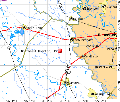
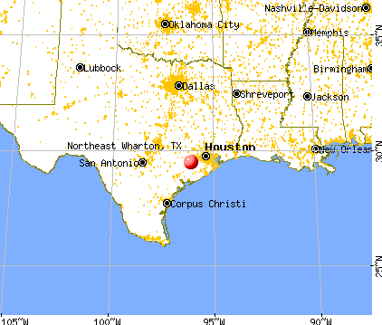
Northeast Wharton, Texas
Submit your own pictures of this place and show them to the world
- OSM Map
- General Map
- Google Map
- MSN Map
| Males: 3,027 | |
| Females: 3,019 |
| Median resident age: | 36.7 years |
| Texas median age: | 32.3 years |
Zip code: 77435
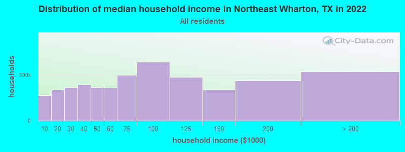
| Northeast Wharton: | $66,874 |
| TX: | $72,284 |
Estimated per capita income in 2022: $32,444 (it was $16,905 in 2000)
Northeast Wharton CCD income, earnings, and wages data
Estimated median house or condo value in 2022: $195,094 (it was $56,200 in 2000)
| Northeast Wharton: | $195,094 |
| TX: | $275,400 |
Northeast Wharton, TX residents, houses, and apartments details
Detailed information about poverty and poor residents in Northeast Wharton, TX


- 3,64359.6%White alone
- 1,24120.3%Black alone
- 1,17419.2%Hispanic
- 290.5%Two or more races
- 90.1%American Indian alone
- 90.1%Asian alone
- 40.07%Other race alone
- 10.02%Native Hawaiian and Other
Pacific Islander alone
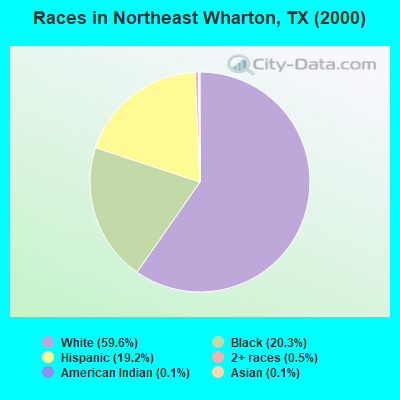
Races in Northeast Wharton detailed stats: ancestries, foreign born residents, place of birth
 Recent articles from our blog. Our writers, many of them Ph.D. graduates or candidates, create easy-to-read articles on a wide variety of topics.

Current Local Time: CST time zone
Land area: 270.1 square miles.
Population density: 22 people per square mile (very low).
| Northeast Wharton CCD: | 1.4% ($798) |
| Texas: | 1.8% ($1,393) |
Nearest city with pop. 50,000+: Sugar Land, TX  (32.2 miles , pop. 63,328).
Nearest city with pop. 200,000+: Houston, TX (49.2 miles , pop. 1,953,631).
Nearest cities:
), ), Latitude: 29.47 N, Longitude: 96.13 W
Area code commonly used in this area: 979

| Here: | 3.5% |
| Texas: | 3.5% |
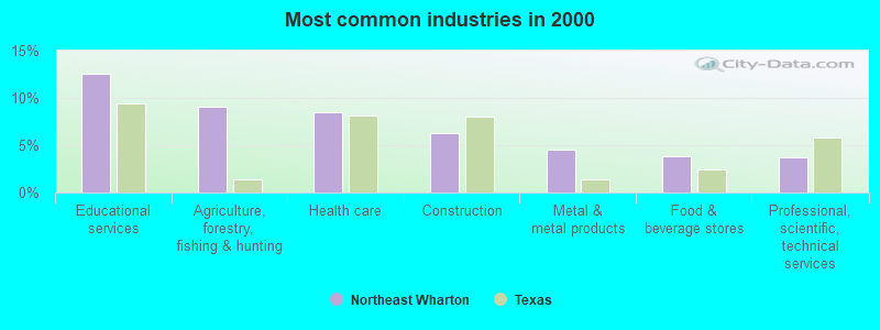
- Educational services (12.5%)
- Agriculture, forestry, fishing & hunting (9.1%)
- Health care (8.5%)
- Construction (6.3%)
- Metal & metal products (4.5%)
- Food & beverage stores (3.8%)
- Professional, scientific, technical services (3.7%)
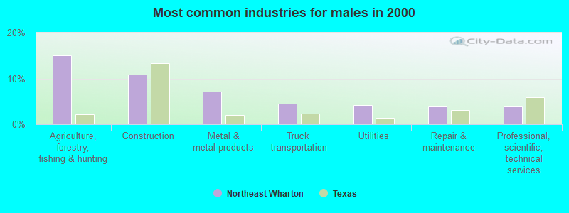
- Agriculture, forestry, fishing & hunting (15.0%)
- Construction (10.8%)
- Metal & metal products (7.1%)
- Truck transportation (4.5%)
- Utilities (4.2%)
- Repair & maintenance (4.0%)
- Professional, scientific, technical services (4.0%)
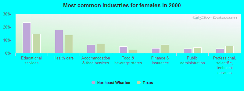
- Educational services (23.5%)
- Health care (17.9%)
- Accommodation & food services (6.4%)
- Food & beverage stores (5.2%)
- Finance & insurance (3.6%)
- Public administration (3.6%)
- Professional, scientific, technical services (3.5%)
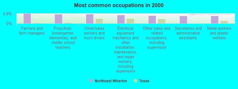
- Farmers and farm managers (4.8%)
- Preschool, kindergarten, elementary, and middle school teachers (4.7%)
- Driver/sales workers and truck drivers (4.6%)
- Electrical equipment mechanics and other installation, maintenance, and repair workers, including supervisors (4.2%)
- Other sales and related occupations, including supervisors (4.0%)
- Secretaries and administrative assistants (3.9%)
- Metal workers and plastic workers (3.8%)
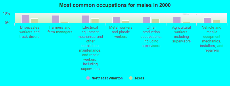
- Driver/sales workers and truck drivers (8.4%)
- Farmers and farm managers (7.8%)
- Electrical equipment mechanics and other installation, maintenance, and repair workers, including supervisors (7.7%)
- Metal workers and plastic workers (6.3%)
- Other production occupations, including supervisors (6.3%)
- Agricultural workers, including supervisors (6.2%)
- Vehicle and mobile equipment mechanics, installers, and repairers (5.3%)

- Preschool, kindergarten, elementary, and middle school teachers (9.8%)
- Secretaries and administrative assistants (8.5%)
- Nursing, psychiatric, and home health aides (5.8%)
- Information and record clerks, except customer service representatives (5.0%)
- Bookkeeping, accounting, and auditing clerks (4.1%)
- Other sales and related occupations, including supervisors (4.0%)
- Health technologists and technicians (3.5%)
Average climate in Northeast Wharton, Texas
Based on data reported by over 4,000 weather stations


Tornado activity:
Northeast Wharton-area historical tornado activity is slightly above Texas state average. It is 55% greater than the overall U.S. average.
On 11/22/1961, a category F3 (max. wind speeds 158-206 mph) tornado 5.8 miles away from the Northeast Wharton place center injured one person.
On 3/28/1966, a category F3 tornado 7.6 miles away from the place center caused between $5000 and $50,000 in damages.
Earthquake activity:
Northeast Wharton-area historical earthquake activity is significantly above Texas state average. It is 36% smaller than the overall U.S. average.On 10/20/2011 at 12:24:41, a magnitude 4.8 (4.8 MW, Depth: 3.1 mi, Class: Light, Intensity: IV - V) earthquake occurred 125.0 miles away from the city center
On 5/17/2012 at 08:12:00, a magnitude 4.8 (4.8 MW, Depth: 3.1 mi) earthquake occurred 199.4 miles away from Northeast Wharton center
On 4/9/1993 at 12:29:19, a magnitude 4.3 (4.1 MB, 4.3 LG, Depth: 3.1 mi) earthquake occurred 128.9 miles away from Northeast Wharton center
On 5/1/2018 at 16:28:56, a magnitude 4.0 (4.0 MW, Depth: 3.1 mi) earthquake occurred 118.7 miles away from the city center
On 6/16/1978 at 11:46:54, a magnitude 5.3 (4.4 MB, 4.6 UK, 5.3 ML, Class: Moderate, Intensity: VI - VII) earthquake occurred 368.3 miles away from the city center
On 4/14/1995 at 00:32:56, a magnitude 5.7 (5.6 MB, 5.7 MS, 5.7 MW, Depth: 11.1 mi) earthquake occurred 437.6 miles away from the city center
Magnitude types: regional Lg-wave magnitude (LG), body-wave magnitude (MB), local magnitude (ML), surface-wave magnitude (MS), moment magnitude (MW)
Natural disasters:
The number of natural disasters in Wharton County (18) is near the US average (15).Major Disasters (Presidential) Declared: 9
Emergencies Declared: 7
Causes of natural disasters: Hurricanes: 8, Storms: 6, Floods: 5, Tornadoes: 3, Fires: 2, Tropical Storm: 1, Wind: 1, Other: 1 (Note: some incidents may be assigned to more than one category).
Hospitals and medical centers near Northeast Wharton:
- AVALON PLACE WHARTON (Nursing Home, about 11 miles away; WHARTON, TX)
- WHARTON NURSING AND REHABILITATION CENTER (Nursing Home, about 11 miles away; WHARTON, TX)
- WHARTON MANOR (Nursing Home, about 12 miles away; WHARTON, TX)
- BENEVOLENT CARE HEALTH SERVICES INC (Home Health Center, about 12 miles away; RICHMOND, TX)
- HERITAGE HOUSE (Nursing Home, about 16 miles away; EAGLE LAKE, TX)
- RICE MEDICAL CENTER (Hospital, about 16 miles away; EAGLE LAKE, TX)
Colleges/universities with over 2000 students nearest to Northeast Wharton:
- Wharton County Junior College (about 11 miles; Wharton, TX; Full-time enrollment: 5,009)
- Houston Baptist University (about 40 miles; Houston, TX; FT enrollment: 2,340)
- Prairie View A & M University (about 44 miles; Prairie View, TX; FT enrollment: 7,517)
- The Art Institute of Houston (about 45 miles; Houston, TX; FT enrollment: 2,429)
- The University of Texas Health Science Center at Houston (about 47 miles; Houston, TX; FT enrollment: 3,023)
- Rice University (about 47 miles; Houston, TX; FT enrollment: 6,713)
- University of St Thomas (about 48 miles; Houston, TX; FT enrollment: 2,747)
Points of interest:
Notable locations in Northeast Wharton: Oakcrest Camp (A), Spanish Camp (B), East Bernard Volunteer Fire Department (C), Egypt Plantation Museum (D), East Bernard Emergency Medical Services (E). Display/hide their locations on the map
Churches in Northeast Wharton include: Saint Luke Church (A), East Gate Church (B), Bonus Church (C), Camp Zion Church (D), Center Union Church (E), Elm Grove Church (F), Mount Vernon Church (G), Jerusalem Church (H), New Colorado Tabernacle (I). Display/hide their locations on the map
Cemeteries: Czech National Cemetery (1), Camp Zion Cemetery (2), Old Jerusalem Cemetery (3), Elm Grove Cemetery (4), Frazer Cemetery (5), Middle Bernard Cemetery (6). Display/hide their locations on the map
Lakes and reservoirs: Northington Lake (A), Rockin Ranch Lake (B). Display/hide their locations on the map
Streams, rivers, and creeks: Sandy Branch (A), Middle Bernard Creek (B), Eagle Branch (C), Gum Tree Branch (D), Lone Tree Creek (E), Caney Creek (F), Dry Branch (G), Dewberry Branch (H), Davis Branch (I). Display/hide their locations on the map
| This place: | 2.8 people |
| Texas: | 2.7 people |
| This place: | 60.7% |
| Whole state: | 71.5% |
| This place: | 4.0% |
| Whole state: | 4.4% |
Likely homosexual households (counted as self-reported same-sex unmarried-partner households)
- Lesbian couples: 0.5% of all households
- Gay men: 0.1% of all households
| This place: | 12.3% |
| Whole state: | 15.4% |
| This place: | 6.2% |
| Whole state: | 6.7% |
People in group quarters in Northeast Wharton in 2000:
- 132 people in homes or halfway houses for drug/alcohol abuse
- 3 people in homes for the mentally retarded
- 3 people in religious group quarters
For population 15 years and over in Northeast Wharton:
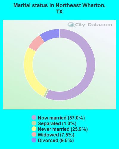
- Never married: 25.9%
- Now married: 57.0%
- Separated: 1.0%
- Widowed: 7.5%
- Divorced: 9.5%
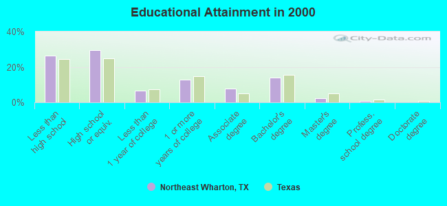
For population 25 years and over in Northeast Wharton:
- High school or higher: 73.5%
- Bachelor's degree or higher: 16.8%
- Graduate or professional degree: 2.9%
- Unemployed: 4.6%
- Mean travel time to work (commute): 28.6 minutes
| Here: | 15.1 |
| Texas average: | 15.6 |
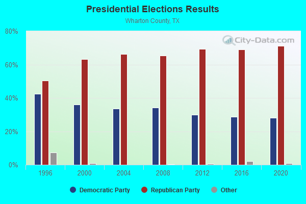
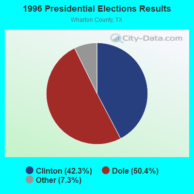
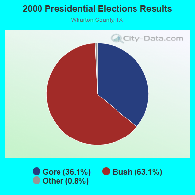
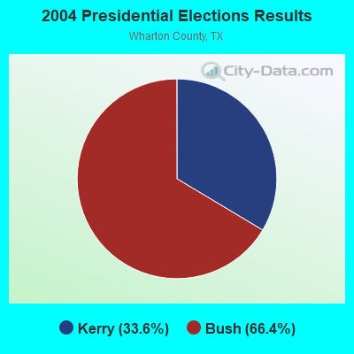
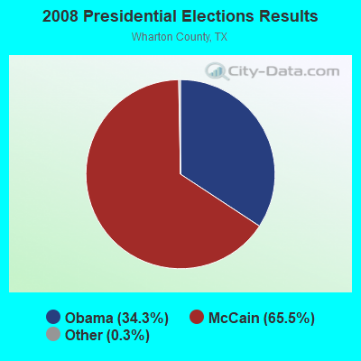
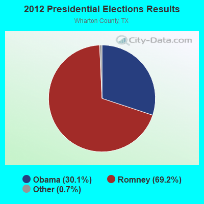


Graphs represent county-level data. Detailed 2008 Election Results
Religion statistics for Northeast Wharton, TX (based on Wharton County data)
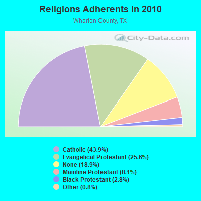
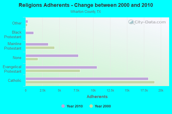
| Religion | Adherents | Congregations |
|---|---|---|
| Catholic | 18,110 | 10 |
| Evangelical Protestant | 10,550 | 48 |
| Mainline Protestant | 3,329 | 16 |
| Black Protestant | 1,169 | 7 |
| Other | 334 | 3 |
| None | 7,788 | - |
Food Environment Statistics:
| This county: | 1.96 / 10,000 pop. |
| Texas: | 1.47 / 10,000 pop. |
| Here: | 2.46 / 10,000 pop. |
| State: | 1.11 / 10,000 pop. |
| Wharton County: | 7.37 / 10,000 pop. |
| Texas: | 3.95 / 10,000 pop. |
| Here: | 5.65 / 10,000 pop. |
| Texas: | 6.13 / 10,000 pop. |
| Wharton County: | 10.3% |
| Texas: | 8.9% |
| Wharton County: | 30.5% |
| Texas: | 26.6% |
| Here: | 19.6% |
| Texas: | 15.7% |
Strongest AM radio stations in Northeast Wharton:
- KREH (900 AM; 5 kW; PECAN GROVE, TX)
- KILE (1560 AM; 50 kW; BELLAIRE, TX; Owner: THE RAFTT CORPORATION)
- KEYH (850 AM; 10 kW; HOUSTON, TX; Owner: LIBERMAN BROADCASTING OF HOUSTON LICENSE CORP.)
- KRTX (980 AM; 5 kW; ROSENBURG/RICHMOND, TX)
- KTRH (740 AM; 50 kW; HOUSTON, TX; Owner: AMFM TEXAS LICENSES LIMITED PARTNERSHIP)
- KGOL (1180 AM; 50 kW; HUMBLE, TX; Owner: ENTRAVISION HOLDINGS, LLC)
- KSEV (700 AM; 15 kW; TOMBALL, TX; Owner: LIBERMAN BROADCASTING OF HOUSTON LICENSE CORP.)
- KTMR (1130 AM; daytime; 10 kW; EDNA, TX; Owner: SIGA BROADCASTING CORPORATION)
- KTKR (760 AM; 50 kW; SAN ANTONIO, TX; Owner: CCB TEXAS LICENSES, L.P.)
- KKHT (1070 AM; 10 kW; HOUSTON, TX; Owner: SOUTH TEXAS BROADCASTING, INC.)
- KCTA (1030 AM; 50 kW; CORPUS CHRISTI, TX; Owner: BROADCASTING CORPORATION OF THE SOUTHWEST)
- WOAI (1200 AM; 50 kW; SAN ANTONIO, TX; Owner: CCB TEXAS LICENSES, L.P.)
- KLAT (1010 AM; 10 kW; HOUSTON, TX; Owner: TICHENOR LICENSE CORPORATION ("TLC"))
Strongest FM radio stations in Northeast Wharton:
- KRBE (104.1 FM; HOUSTON, TX; Owner: KRBE LICO, INC.)
- KBXX (97.9 FM; HOUSTON, TX; Owner: RADIO ONE LICENSES, LLC)
- KHJZ-FM (95.7 FM; HOUSTON, TX; Owner: TEXAS INFINITY BROADCASTING L.P.)
- KHMX (96.5 FM; HOUSTON, TX; Owner: CITICASTERS LICENSES, L.P.)
- KILT-FM (100.3 FM; HOUSTON, TX; Owner: TEXAS INFINITY BROADCASTING L.P.)
- KKBQ-FM (92.9 FM; PASADENA, TX; Owner: CXR HOLDINGS, INC.)
- KLOL (101.1 FM; HOUSTON, TX; Owner: AMFM TEXAS LICENSES LIMITED PARTNERSHIP)
- KODA (99.1 FM; HOUSTON, TX; Owner: AMFM TEXAS LICENSES LIMITED PARTNERSHIP)
- KTBZ-FM (94.5 FM; HOUSTON, TX; Owner: AMFM TEXAS LICENSES LIMITED PARTNERSHIP)
- KKRW (93.7 FM; HOUSTON, TX; Owner: CAPSTAR TX LIMITED PARTNERSHIP)
- KUHF (88.7 FM; HOUSTON, TX; Owner: UNIVERSITY OF HOUSTON SYSTEM)
- KHCB-FM (105.7 FM; HOUSTON, TX; Owner: HOUSTON CHRISTIAN BROADCASTERS, INC.)
- KMJQ (102.1 FM; HOUSTON, TX; Owner: RADIO ONE LICENSES, LLC)
- KLDE (107.5 FM; LAKE JACKSON, TX; Owner: CXR HOLDINGS, INC.)
- KPTY (104.9 FM; MISSOURI CITY, TX; Owner: TICHENOR LICENSE CORPORATION ("TLC"))
- KIOX-FM (96.9 FM; EL CAMPO, TX; Owner: LIBERMAN BROADCASTING OF HOUSTON LICENSE CORP.)
- KXGJ (101.7 FM; BAY CITY, TX; Owner: LIBERMAN BROADCASTING OF HOUSTON LICENSE CORP.)
TV broadcast stations around Northeast Wharton:
- KHOU-TV (Channel 11; HOUSTON, TX; Owner: KHOU-TV, L.P.)
- KPRC-TV (Channel 2; HOUSTON, TX; Owner: POST-NEWSWEEK STATIONS, HOUSTON, LP)
- KPXB (Channel 49; CONROE, TX; Owner: PAXSON HOUSTON LICENSE, INC.)
- KTBU (Channel 55; CONROE, TX; Owner: HUMANITY INTERESTED MEDIA, INC.)
- KFTH (Channel 67; ALVIN, TX; Owner: TELEFUTURA HOUSTON LLC)
- KTXH (Channel 20; HOUSTON, TX; Owner: FOX TELEVISION STATIONS, INC.)
- KNWS-TV (Channel 51; KATY, TX; Owner: JOHNSON BROADCASTING, INC.)
- KXLN-TV (Channel 45; ROSENBERG, TX; Owner: KXLN LICENSE PARTNERSHIP, L.P.)
- KHWB (Channel 39; HOUSTON, TX; Owner: KHWB, INC.)
- KRIV (Channel 26; HOUSTON, TX; Owner: FOX TELEVISION STATIONS, INC.)
- KZJL (Channel 61; HOUSTON, TX; Owner: KZJL LICENSE CORP.)
- KETH (Channel 14; HOUSTON, TX; Owner: COMMUNITY EDUCATIONAL TV, INC.)
- KTRK-TV (Channel 13; HOUSTON, TX; Owner: KTRK TELEVISION, INC.)
- KUHT (Channel 8; HOUSTON, TX; Owner: UNIVERSITY OF HOUSTON SYSTEM)
- KVDO-LP (Channel 69; CLEAR LAKE, TX; Owner: FAR EASTERN TELECASTERS)
- KBPX-LP (Channel 33; HOUSTON, TX; Owner: PAXSON COMMUNICATIONS LPTV, INC.)
- KJIB-LP (Channel 5; CLEAR LAKE CITY, TX; Owner: FAR EASTERN TELECASTERS)
- KHMV-LP (Channel 28; HOUSTON, TX; Owner: PAPPAS TELECASTING OF THE GULF COAST, A CALIFORNIA LP)
- KTMD (Channel 48; GALVESTON, TX; Owner: TELEMUNDO OF TEXAS PARTNERSHIP, LP)
- KAZH (Channel 57; BAYTOWN, TX; Owner: KAZH LICENSE, LLC)
- KVIT-LP (Channel 28; VICTORIA, TX; Owner: CLUB COMMUNICATIONS)
- KLTJ (Channel 22; GALVESTON, TX; Owner: WORD OF GOD FELLOWSHIP, INC.)
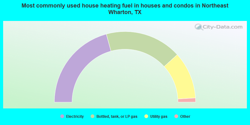
- 41.5%Electricity
- 35.0%Bottled, tank, or LP gas
- 21.6%Utility gas
- 0.5%Fuel oil, kerosene, etc.
- 0.5%Wood
- 0.5%No fuel used
- 0.4%Other fuel
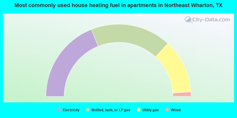
- 37.8%Electricity
- 36.0%Bottled, tank, or LP gas
- 24.2%Utility gas
- 2.0%Wood
Northeast Wharton compared to Texas state average:
- Unemployed percentage significantly below state average.
- Black race population percentage above state average.
- Hispanic race population percentage below state average.
- Median age above state average.
- Foreign-born population percentage significantly below state average.
- Renting percentage significantly below state average.
- Length of stay since moving in significantly above state average.
- Number of rooms per house significantly below state average.
- House age significantly below state average.
- Number of college students below state average.
Northeast Wharton on our top lists:
- #1 on the list of "Top 101 cities with largest percentage of females in occupations: occupational and physical therapist assistants and aides (population 5,000+)"
- #4 on the list of "Top 101 cities with largest percentage of males in industries: alcoholic beverages merchant wholesalers (population 5,000+)"
- #11 on the list of "Top 101 cities with largest percentage of females in industries: furniture and related product manufacturing (population 5,000+)"
- #13 on the list of "Top 101 cities with largest percentage of females in occupations: drafters, engineering, and mapping technicians (population 5,000+)"
- #14 on the list of "Top 101 cities with largest percentage of females in industries: paper and paper products merchant wholesalers (population 5,000+)"
- #15 on the list of "Top 101 cities with largest percentage of males in occupations: farmers and farm managers (population 5,000+)"
- #17 on the list of "Top 101 cities with largest percentage of males in industries: nonmetallic mineral products (population 5,000+)"
- #18 on the list of "Top 101 cities with largest percentage of females in occupations: woodworkers (population 5,000+)"
- #18 on the list of "Top 101 cities with largest percentage of females in industries: farm product raw materials merchant wholesalers (population 5,000+)"
- #20 on the list of "Top 101 cities with the largest percentage of people in homes or halfway houses for drug/alcohol abuse (population 1,000+)"
- #23 on the list of "Top 101 cities with largest percentage of males in occupations: other healthcare support occupations (population 5,000+)"
- #24 on the list of "Top 101 cities with largest percentage of males in industries: machinery, equipment, and supplies merchant wholesalers (population 5,000+)"
- #25 on the list of "Top 101 cities with largest percentage of females in occupations: preschool, kindergarten, elementary and middle school teachers (population 5,000+)"
- #28 on the list of "Top 101 cities with the largest house values disparities (population 5,000+)"
- #51 on the list of "Top 101 cities with largest percentage of females in industries: fuel dealers (population 5,000+)"
- #64 on the list of "Top 101 cities with largest percentage of males in industries: miscellaneous nondurable goods merchant wholesalers (population 5,000+)"
- #69 on the list of "Top 101 cities with largest percentage of males in industries: metal and metal products (population 5,000+)"
- #81 on the list of "Top 101 cities with largest percentage of males in industries: drugs, sundries, and chemical and allied products merchant wholesalers (population 5,000+)"
- #87 on the list of "Top 101 cities with largest percentage of females in industries: nonmetallic mineral products (population 5,000+)"
- #87 on the list of "Top 101 cities with largest percentage of females in industries: private households (population 5,000+)"
- #21 (77435) on the list of "Top 101 zip codes with the largest percentage of Czech first ancestries"