Millerville-Hollins, Alabama
Submit your own pictures of this place and show them to the world
- OSM Map
- Google Map
- MSN Map
| Males: 1,207 | |
| Females: 1,166 |
| Median resident age: | 38.0 years |
| Alabama median age: | 35.8 years |
Zip code: 35160
| Millerville-Hollins: | $50,658 |
| AL: | $59,674 |
Estimated per capita income in 2022: $29,883 (it was $14,528 in 2000)
Millerville-Hollins CCD income, earnings, and wages data
Estimated median house or condo value in 2022: $135,773 (it was $48,800 in 2000)
| Millerville-Hollins: | $135,773 |
| AL: | $200,900 |
Mean prices in 2022: all housing units: $164,993; detached houses: $206,136; townhouses or other attached units: $160,781; mobile homes: $55,329
Millerville-Hollins, AL residents, houses, and apartments details
Detailed information about poverty and poor residents in Millerville-Hollins, AL


- 2,01982.1%White alone
- 40516.5%Black alone
- 180.7%Two or more races
- 100.4%American Indian alone
- 60.2%Hispanic

 Recent articles from our blog. Our writers, many of them Ph.D. graduates or candidates, create easy-to-read articles on a wide variety of topics.

Current Local Time: CST time zone
Land area: 191.0 square miles.
Population density: 12 people per square mile (very low).
| Millerville-Hollins CCD: | 0.4% ($199) |
| Alabama: | 0.4% ($289) |
Nearest city with pop. 50,000+: Hoover, AL  (47.4 miles , pop. 62,742).
Nearest city with pop. 200,000+: Birmingham, AL (51.6 miles , pop. 242,820).
Nearest city with pop. 1,000,000+: Houston, TX (600.1 miles , pop. 1,953,631).
Nearest cities:
), ), ), ), ), Latitude: 33.17 N, Longitude: 86.02 W
Area code commonly used in this area: 256

| Here: | 2.3% |
| Alabama: | 2.6% |

- Furniture & related product manufacturing (12.6%)
- Textile mills & textile products (9.1%)
- Health care (7.2%)
- Construction (6.8%)
- Agriculture, forestry, fishing & hunting (6.6%)
- Educational services (4.2%)
- Public administration (4.0%)

- Furniture & related product manufacturing (14.1%)
- Construction (11.8%)
- Agriculture, forestry, fishing & hunting (11.5%)
- Textile mills & textile products (11.3%)
- Utilities (5.0%)
- Public administration (4.9%)
- Truck transportation (3.6%)

- Health care (14.2%)
- Furniture & related product manufacturing (10.6%)
- Educational services (9.9%)
- Textile mills & textile products (6.1%)
- Accommodation & food services (5.2%)
- Apparel (4.5%)
- Food & beverage stores (4.2%)

- Other production occupations, including supervisors (7.1%)
- Textile, apparel, and furnishings workers (7.0%)
- Metal workers and plastic workers (6.3%)
- Electrical equipment mechanics and other installation, maintenance, and repair workers, including supervisors (6.0%)
- Driver/sales workers and truck drivers (5.3%)
- Material recording, scheduling, dispatching, and distributing workers (5.2%)
- Laborers and material movers, hand (5.0%)

- Electrical equipment mechanics and other installation, maintenance, and repair workers, including supervisors (10.4%)
- Metal workers and plastic workers (9.7%)
- Driver/sales workers and truck drivers (8.5%)
- Other production occupations, including supervisors (7.5%)
- Fishing, hunting, and forestry occupations (6.9%)
- Material recording, scheduling, dispatching, and distributing workers (6.1%)
- Textile, apparel, and furnishings workers (5.7%)

- Textile, apparel, and furnishings workers (8.7%)
- Laborers and material movers, hand (8.7%)
- Preschool, kindergarten, elementary, and middle school teachers (7.5%)
- Other production occupations, including supervisors (6.6%)
- Information and record clerks, except customer service representatives (6.4%)
- Cashiers (6.1%)
- Registered nurses (5.2%)
Average climate in Millerville-Hollins, Alabama
Based on data reported by over 4,000 weather stations


Tornado activity:
Millerville-Hollins-area historical tornado activity is near Alabama state average. It is 96% greater than the overall U.S. average.
On 5/1/1953, a category F4 (max. wind speeds 207-260 mph) tornado 6.4 miles away from the Millerville-Hollins place center killed 7 people and injured 12 people and caused between $50,000 and $500,000 in damages.
On 1/24/1964, a category F4 tornado 23.2 miles away from the place center killed 10 people and injured 6 people and caused between $50,000 and $500,000 in damages.
Earthquake activity:
Millerville-Hollins-area historical earthquake activity is significantly above Alabama state average. It is 88% greater than the overall U.S. average.On 4/29/2003 at 08:59:39, a magnitude 4.9 (4.4 MB, 4.6 MW, 4.9 LG, Class: Light, Intensity: IV - V) earthquake occurred 94.1 miles away from Millerville-Hollins center
On 1/18/1999 at 07:00:53, a magnitude 4.8 (4.8 MB, 4.0 LG, Depth: 0.6 mi) earthquake occurred 72.9 miles away from Millerville-Hollins center
On 4/29/2003 at 08:59:39, a magnitude 4.6 (4.6 MW, Depth: 12.3 mi) earthquake occurred 94.1 miles away from Millerville-Hollins center
On 10/24/1997 at 08:35:17, a magnitude 4.9 (4.8 MB, 4.2 MS, 4.9 LG, Depth: 6.2 mi) earthquake occurred 159.5 miles away from Millerville-Hollins center
On 6/24/1975 at 11:11:36, a magnitude 4.5 (4.5 MB) earthquake occurred 111.3 miles away from the city center
On 8/2/1974 at 08:52:09, a magnitude 4.9 (4.3 MB, 4.9 LG) earthquake occurred 209.6 miles away from Millerville-Hollins center
Magnitude types: regional Lg-wave magnitude (LG), body-wave magnitude (MB), surface-wave magnitude (MS), moment magnitude (MW)
Natural disasters:
The number of natural disasters in Clay County (18) is near the US average (15).Major Disasters (Presidential) Declared: 10
Emergencies Declared: 6
Causes of natural disasters: Storms: 8, Floods: 7, Hurricanes: 6, Tornadoes: 6, Winds: 3, Drought: 1, Snowfall: 1, Winter Storm: 1, Other: 1 (Note: some incidents may be assigned to more than one category).
Hospitals and medical centers near Millerville-Hollins:
- FAITH HOMECARE HOSPICE (Hospital, about 13 miles away; SYLACAUGA, AL)
- COOSA VALLEY HOMECARE (Home Health Center, about 14 miles away; SYLACAUGA, AL)
- COOSA VALLEY MEDICAL CENTER Acute Care Hospitals (about 14 miles away; SYLACAUGA, AL)
- COOSA VALLEY NURSING FACILITY (Nursing Home, about 14 miles away; SYLACAUGA, AL)
- FMC SYLACAUGA (Dialysis Facility, about 14 miles away; SYLACAUGA, AL)
- SHELBY COUNTY HEALTH DEPARTMENT (Home Health Center, about 14 miles away; SYLACAUGA, AL)
- TALLADEGA COUNTY HOME CARE AGENCY (Home Health Center, about 14 miles away; SYLACAUGA, AL)
Colleges/universities with over 2000 students nearest to Millerville-Hollins:
- Southern Union State Community College (about 27 miles; Wadley, AL; Full-time enrollment: 4,120)
- Jacksonville State University (about 48 miles; Jacksonville, AL; FT enrollment: 7,566)
- Samford University (about 49 miles; Birmingham, AL; FT enrollment: 3,829)
- University of Montevallo (about 49 miles; Montevallo, AL; FT enrollment: 2,826)
- Virginia College-Birmingham (about 51 miles; Birmingham, AL; FT enrollment: 8,167)
- Auburn University (about 51 miles; Auburn University, AL; FT enrollment: 22,741)
- University of Alabama at Birmingham (about 51 miles; Birmingham, AL; FT enrollment: 14,853)
Points of interest:
Notable locations in Millerville-Hollins: Hollins Wildlife Camping Area (A), Hollins Hunter Camp (B), Pierces Mill (C), Millerville Volunteer Fire Department (D), Hollins Fire and Rescue (E), Coleta Valley Volunteer Fire Department (F), Tri - Community Volunteer Fire Department Goodwater Station (G). Display/hide their locations on the map
Churches in Millerville-Hollins include: New Hope Church (A), New Prospect Primitive Baptist Church (B), Millerville Church (C), Fairview Church (D), Hollins Spring Church (E), Victory Church (F), Hatchett Creek Presbyterian Church (G), First Presbyterian Church (H), First Baptist Church (I). Display/hide their locations on the map
Cemeteries: Westview Cemetery (1), Simmons Cemetery (2), Liberty Cemetery (3), Antioch Cemetery (4), Bethlehem Cemetery (5), Hatchett Creek Cemetery (6), Hollins Springs Cemetery (7). Display/hide their locations on the map
Reservoirs: Jacksons Lake (A), Gilpins Lake (B), Bolton Lake (C), Lake Pruitt (D). Display/hide their locations on the map
Streams, rivers, and creeks: Shoal Creek (A), Harbuck Creek (B), Little Creek (C), Little Hatchet Creek (D), Mill Creek (E), Moss Rock Branch (F), Partridge Creek (G), Ray Creek (H), Saxon Creek (I). Display/hide their locations on the map
| This place: | 2.5 people |
| Alabama: | 2.5 people |
| This place: | 72.9% |
| Whole state: | 67.8% |
| This place: | 4.9% |
| Whole state: | 4.7% |
Likely homosexual households (counted as self-reported same-sex unmarried-partner households)
- Lesbian couples: 0.6% of all households
- Gay men: 0.5% of all households
| This place: | 19.3% |
| Whole state: | 16.1% |
| This place: | 7.9% |
| Whole state: | 7.3% |
For population 15 years and over in Millerville-Hollins:

- Never married: 18.4%
- Now married: 64.5%
- Separated: 2.4%
- Widowed: 7.6%
- Divorced: 9.4%
For population 25 years and over in Millerville-Hollins:
- High school or higher: 67.2%
- Bachelor's degree or higher: 4.7%
- Graduate or professional degree: 1.2%
- Unemployed: 6.5%
- Mean travel time to work (commute): 31.3 minutes


| Here: | 12.0 |
| Alabama average: | 13.2 |
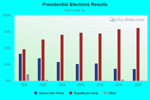
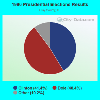
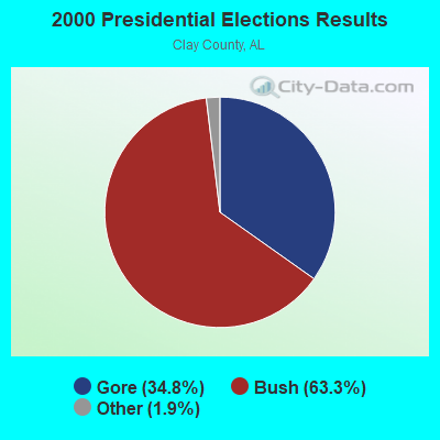

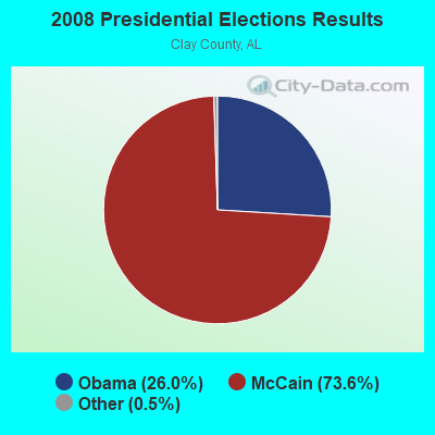
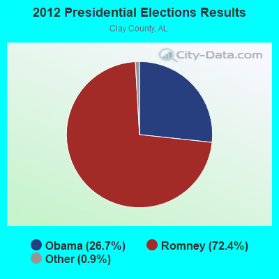
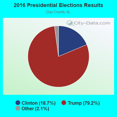
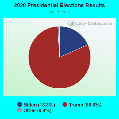
Graphs represent county-level data. Detailed 2008 Election Results
Religion statistics for Millerville-Hollins, AL (based on Clay County data)
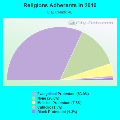
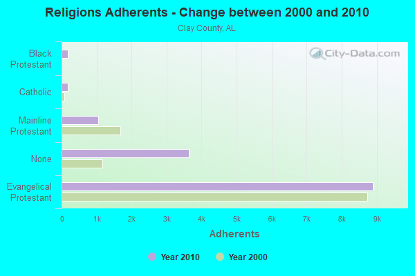
| Religion | Adherents | Congregations |
|---|---|---|
| Evangelical Protestant | 8,899 | 53 |
| Mainline Protestant | 1,038 | 12 |
| Catholic | 186 | 1 |
| Black Protestant | 181 | 2 |
| Other | 1 | 1 |
| None | 3,627 | - |
Food Environment Statistics:
| This county: | 2.17 / 10,000 pop. |
| Alabama: | 1.89 / 10,000 pop. |
| This county: | 0.72 / 10,000 pop. |
| State: | 0.65 / 10,000 pop. |
| Here: | 7.25 / 10,000 pop. |
| Alabama: | 6.32 / 10,000 pop. |
| Clay County: | 4.35 / 10,000 pop. |
| Alabama: | 5.75 / 10,000 pop. |
| Here: | 12.4% |
| Alabama: | 11.8% |
| Here: | 31.6% |
| Alabama: | 31.7% |
| Clay County: | 14.1% |
| Alabama: | 13.5% |
Strongest AM radio stations in Millerville-Hollins:
- WZZX (780 AM; daytime; 5 kW; LINEVILLE, AL; Owner: ROBERT A. PERRY)
- WNSI (810 AM; 50 kW; JACKSONVILLE, AL; Owner: UNITED BROADCASTING NETWORK, INC.)
- WJOX (690 AM; 50 kW; BIRMINGHAM, AL; Owner: CITADEL BROADCASTING COMPANY)
- WDJC (850 AM; 50 kW; BIRMINGHAM, AL; Owner: KIMTRON, INC.)
- WAPI (1070 AM; 50 kW; BIRMINGHAM, AL; Owner: CITADEL BROADCASTING COMPANY)
- WKNG (1060 AM; daytime; 50 kW; TALLAPOOSA, GA; Owner: WKNG, INC.)
- WGST (640 AM; 50 kW; ATLANTA, GA; Owner: CITICASTERS LICENSES, L.P.)
- WYEA (1290 AM; 1 kW; SYLACAUGA, AL; Owner: SPIRIT BROADCASTING CO., INC.)
- WCNN (680 AM; 50 kW; NORTH ATLANTA, GA; Owner: DICKEY BROADCASTING COMPANY)
- WFEB (1340 AM; 1 kW; SYLACAUGA, AL; Owner: ALABAMA BROADCASTING COMPANY, INC.)
- WSB (750 AM; 50 kW; ATLANTA, GA; Owner: CXR HOLDINGS, INC.)
- WMLB (1160 AM; 50 kW; EAST POINT, GA; Owner: ATLANTA AREA BROADCASTING, INC.)
- WFTD (1080 AM; daytime; 50 kW; MARIETTA, GA; Owner: PRIETO ENTERPRISES, INC.)
Strongest FM radio stations in Millerville-Hollins:
- WTBJ (91.3 FM; OXFORD, AL; Owner: TRINITY CHRISTIAN ACADEMY)
- WTRB-FM (98.3 FM; SYLACAUGA, AL; Owner: WILLIAMS COMMUNICATIONS, INC.)
- WASZ (95.5 FM; ASHLAND, AL; Owner: WILLIAMS COMMUNICATIONS, INC.)
- WTDR (92.7 FM; TALLADEGA, AL; Owner: JACOBS BROADCAST GROUP, INC.)
- WSSY-FM (97.5 FM; TALLADEGA, AL; Owner: GREAT SOUTH RFDC, LLC)
- WVOK-FM (97.9 FM; OXFORD, AL; Owner: WOODARD BROADCASTING CO. INC.)
- WLWI-FM (92.3 FM; MONTGOMERY, AL; Owner: CUMULUS LICENSING CORP.)
- WZLM (97.3 FM; DADEVILLE, AL; Owner: GREAT SOUTH RFDC, LLC)
- WGIB (91.9 FM; BIRMINGHAM, AL; Owner: GLEN IRIS BAPTIST SCHOOL)
- WMAX-FM (105.3 FM; BOWDON, GA; Owner: CLEAR CHANNEL BROADCASTING LICENSES, INC.)
- WBHK (98.7 FM; WARRIOR, AL; Owner: CXR HOLDINGS, INC.)
- WBPT (106.9 FM; BIRMINGHAM, AL; Owner: CXR HOLDINGS, INC.)
- WZZK-FM (104.7 FM; BIRMINGHAM, AL; Owner: CXR HOLDINGS, INC.)
- WSTH-FM (106.1 FM; ALEXANDER CITY, AL; Owner: CLEAR CHANNEL BROADCASTING LICENSES, INC.)
TV broadcast stations around Millerville-Hollins:
- WCIQ (Channel 7; MOUNT CHEAHA, AL; Owner: ALABAMA EDUCATIONAL TELEVISION COMMISSION)
- WNCF (Channel 32; MONTGOMERY, AL; Owner: CHANNEL 32 MONTGOMERY LLC)
- WAXC-LP (Channel 64; ALEXANDER CITY, AL; Owner: CABLE VIDEO PRODUCTIONS, INC.)
- National Bridge Inventory (NBI) Statistics
- 1Number of bridges
- 10ft / 3.3mTotal length
- $723,000Total costs
- 1,232Total average daily traffic
- 73Total average daily truck traffic
- 1,725Total future (year 2039) average daily traffic

- 44.7%Bottled, tank, or LP gas
- 37.3%Electricity
- 9.7%Utility gas
- 7.5%Wood
- 0.9%Other fuel

- 53.7%Bottled, tank, or LP gas
- 17.6%Utility gas
- 16.9%Electricity
- 11.8%Fuel oil, kerosene, etc.
Millerville-Hollins compared to Alabama state average:
- Unemployed percentage below state average.
- Hispanic race population percentage significantly below state average.
- Median age below state average.
- Foreign-born population percentage significantly below state average.
- Renting percentage below state average.
- Length of stay since moving in significantly above state average.
- Number of rooms per house significantly below state average.
- House age significantly below state average.
- Number of college students significantly below state average.
- Percentage of population with a bachelor's degree or higher significantly below state average.