Killingly, Connecticut
Submit your own pictures of this town and show them to the world
- OSM Map
- Google Map
- MSN Map
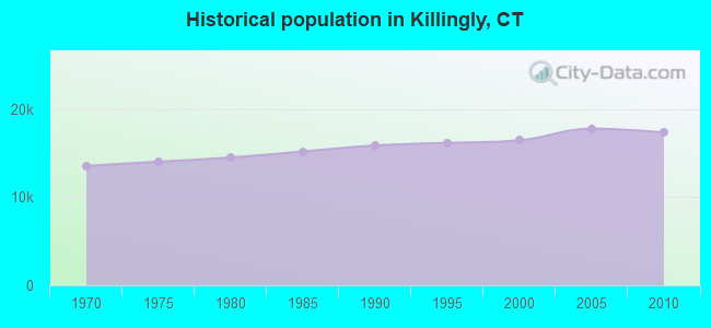
Population change since 2000: +5.5%
 |
| Males: 8,570 | |
| Females: 8,800 |
| Median resident age: | 39.8 years |
| Connecticut median age: | 39.2 years |
Zip codes: 06239.
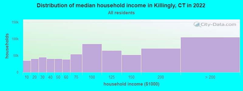
| Killingly: | $67,364 |
| CT: | $88,429 |
Estimated per capita income in 2022: $35,466 (it was $19,779 in 2000)
Killingly town income, earnings, and wages data
Estimated median house or condo value in 2022: $233,917 (it was $108,200 in 2000)
| Killingly: | $233,917 |
| CT: | $347,200 |
Mean prices in 2022: all housing units: $270,250; detached houses: $283,786; townhouses or other attached units: $235,819; in 2-unit structures: $159,195; in 3-to-4-unit structures: $165,857; in 5-or-more-unit structures: $105,814; mobile homes: $180,020
Detailed information about poverty and poor residents in Killingly, CT
Compare current foreclosures near Killingly, CT:
| Photo | Address | Area | Beds / Baths | Price | Details |
|---|---|---|---|---|---|

|
#1
Mount Pleasant Rd
Harrisville, RI 02830
|
1,232 sq. feet
|
1 baths 3 beds |
$449,900
|
show details |

|
#2
Round Lake Dr
Pascoag, RI 02859
|
976 sq. feet
|
2 baths 2 beds |
$179,900
|
show details |

|
#3
N Society Rd
Canterbury, CT 06331
|
768 sq. feet
|
1 baths 2 beds |
$269,900
|
show details |

|
#4
Old Turnpike Road
Thompson, CT 06277
|
1,316 sq. feet
|
1 baths 4 beds |
show details | |

|
#5
Peckham Ln
Coventry, RI 02816
|
2,623 sq. feet
|
3 baths 3 beds |
show details | |

|
#6
Putnam Pike
Greenville, RI 02828
|
1,114 sq. feet
|
1 baths 2 beds |
show details | |

|
#7
N Main St
Pascoag, RI 02859
|
- sq. feet
|
- baths - beds |
$100,000
|
show details |

|
#8
Boys Ave
Rogers, CT 06263
|
- sq. feet
|
2 baths 6 beds |
show details | |

|
#9
Paine District Rd
Woodstock, CT 06281
|
1,092 sq. feet
|
1 baths 2 beds |
show details | |

|
#10
Snake Hill Rd
North Scituate, RI 02857
|
864 sq. feet
|
2 baths 2 beds |
show details |
| Photo | Address | Area | Beds / Baths | Price | Details |
|---|---|---|---|---|---|

|
#11
Hall Rd
Webster, MA 01570
|
2,421 sq. feet
|
2 baths 3 beds |
show details | |

|
#12
Hopkins Ave
Johnston, RI 02919
|
1,786 sq. feet
|
2 baths 3 beds |
show details | |

|
#13
Rawson Rd
Woodstock, CT 06281
|
2,556 sq. feet
|
2 baths 3 beds |
show details | |

|
#14
Lower Gore Rd
Webster, MA 01570
|
1,888 sq. feet
|
1 baths 4 beds |
show details | |

|
#15
Highcrest Park
Webster, MA 01570
|
1,536 sq. feet
|
2 baths 2 beds |
show details | |

|
#16
Warsaw Ave
Dudley, MA 01571
|
1,484 sq. feet
|
2 baths 3 beds |
show details | |

|
#17
Hopeville Rd
Jewett City, CT 06351
|
1,939 sq. feet
|
2 baths 3 beds |
show details | |

|
#18
William Henry Rd
North Scituate, RI 02857
|
1,458 sq. feet
|
2 baths 3 beds |
show details | |

|
#19
Old Carriage Rd
Coventry, RI 02816
|
1,092 sq. feet
|
1 baths 2 beds |
show details | |

|
#20
Vale Ct
West Greenwich, RI 02817
|
1,944 sq. feet
|
2 baths 3 beds |
show details |
| Photo | Address | Area | Beds / Baths | Price | Details |
|---|---|---|---|---|---|

|
#21
Pine Crest Rdg
Woodstock, CT 06281
|
926 sq. feet
|
1 baths 2 beds |
show details | |

|
#22
Fanning Ln
Greenville, RI 02828
|
1,814 sq. feet
|
2 baths 3 beds |
show details | |

|
#23
Maplewood Dr
Mapleville, RI 02839
|
732 sq. feet
|
1 baths 2 beds |
show details | |

|
#24
Archer Way
Coventry, RI 02816
|
1,680 sq. feet
|
1 baths 2 beds |
show details | |

|
#25
Johnathan Pass
Dudley, MA 01571
|
2,570 sq. feet
|
2 baths 3 beds |
show details | |

|
#26
Cooper Hill Rd
Mapleville, RI 02839
|
1,448 sq. feet
|
1 baths 4 beds |
show details | |

|
#27
Perryville Rd
Webster, MA 01570
|
1,424 sq. feet
|
2 baths 3 beds |
show details | |

|
#28
Ernest St
Webster, MA 01570
|
1,330 sq. feet
|
2 baths 3 beds |
show details | |

|
#29
Roode Rd
Jewett City, CT 06351
|
1,104 sq. feet
|
1 baths 3 beds |
show details | |

|
#30
Cross St
Danielson, CT 06239
|
1,080 sq. feet
|
1 baths 3 beds |
show details |
| Photo | Address | Area | Beds / Baths | Price | Details |
|---|---|---|---|---|---|

|
#31
Mapleville Main St
Mapleville, RI 02839
|
2,362 sq. feet
|
2 baths 8 beds |
show details | |

|
#32
Pachaug River Dr
Jewett City, CT 06351
|
1,428 sq. feet
|
2 baths 3 beds |
show details | |

|
#33
Francis St
Danielson, CT 06239
|
1,260 sq. feet
|
1 baths 3 beds |
show details | |

|
#34
Washington Dr
Johnston, RI 02919
|
2,947 sq. feet
|
2 baths 4 beds |
show details | |

|
#35
Pine St
Dudley, MA 01571
|
1,383 sq. feet
|
2 baths 3 beds |
show details | |

|
#36
Spencer Rd
Greenville, RI 02828
|
1,825 sq. feet
|
2 baths 4 beds |
show details | |

|
#37
Spencer Rd
Greenville, RI 02828
|
1,825 sq. feet
|
2 baths 4 beds |
show details | |

|
#38
Glasgo Rd Lot 208
Jewett City, CT 06351
|
1,680 sq. feet
|
2 baths 3 beds |
show details | |

|
#39
Glasgo Rd Lot 208
Jewett City, CT 06351
|
1,680 sq. feet
|
2 baths 3 beds |
show details | |

|
#40
Atwoodville Ln
Mansfield Center, CT 06250
|
2,256 sq. feet
|
3 baths 2 beds |
show details |
| Photo | Address | Area | Beds / Baths | Price | Details |
|---|---|---|---|---|---|

|
#41
Market St
Webster, MA 01570
|
2,520 sq. feet
|
2 baths 6 beds |
show details | |

|
#42
Burlingame Rd
Smithfield, RI 02917
|
1,454 sq. feet
|
2 baths 3 beds |
show details | |

|
#43
Douglas Cir
Greenville, RI 02828
|
960 sq. feet
|
1 baths 3 beds |
show details | |

|
#44
Dresser Hill Rd
Dudley, MA 01571
|
994 sq. feet
|
1 baths 3 beds |
show details | |

|
#45
Pine St
Dudley, MA 01571
|
1,118 sq. feet
|
1 baths 2 beds |
show details | |

|
#46
Greenville Ave
Greenville, RI 02828
|
932 sq. feet
|
1 baths 1 beds |
show details | |

|
#47
Potash Hill Rd
Baltic, CT 06330
|
1,028 sq. feet
|
1 baths 3 beds |
show details | |

|
#48
South St
Douglas, MA 01516
|
1,685 sq. feet
|
1 baths 3 beds |
show details | |

|
#49
Hillside Ave
Webster, MA 01570
|
1,445 sq. feet
|
1 baths 3 beds |
show details | |

|
Check over 1 million property listings on Foreclosure.com!
|
browse all offers | |||

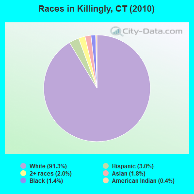
- 15,86591.3%White alone
- 5163.0%Hispanic
- 3542.0%Two or more races
- 3121.8%Asian alone
- 2441.4%Black alone
- 650.4%American Indian alone
- 120.07%Other race alone
- 20.01%Native Hawaiian and Other
Pacific Islander alone
Races in Killingly detailed stats: ancestries, foreign born residents, place of birth
According to our research of Connecticut and other state lists, there were 4 registered sex offenders living in Killingly, Connecticut as of April 27, 2024.
The ratio of all residents to sex offenders in Killingly is 4,343 to 1.
The ratio of registered sex offenders to all residents in this city is much lower than the state average.
 Recent articles from our blog. Our writers, many of them Ph.D. graduates or candidates, create easy-to-read articles on a wide variety of topics.

Ancestries: French (25.9%), Irish (14.8%), French Canadian (14.7%), English (11.6%), Polish (8.3%), Italian (7.9%).
Current Local Time: EST time zone
Incorporated on 05/1708
Land area: 48.5 square miles.
Population density: 358 people per square mile (very low).
493 residents are foreign born (1.5% Europe, 0.8% Asia, 0.4% North America, 0.3% Latin America).
| This town: | 3.0% |
| Connecticut: | 10.9% |
| Killingly town: | 1.2% ($1,351) |
| Connecticut: | 1.8% ($2,961) |
Nearest city with pop. 50,000+: Cranston, RI (21.2 miles  , pop. 79,269).
Nearest city with pop. 200,000+: Boston, MA (52.5 miles , pop. 589,141).
Nearest city with pop. 1,000,000+: Bronx, NY (124.5 miles , pop. 1,332,650).
Nearest cities:
), ), ), Latitude: 41.82 N, Longitude: 71.86 W
Area code commonly used in this area: 860
Killingly, Connecticut accommodation & food services, waste management - Economy and Business Data
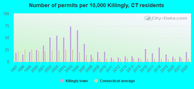
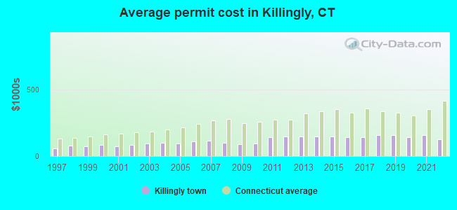
Single-family new house construction building permits:
- 2022: 35 buildings, average cost: $127,300
- 2021: 18 buildings, average cost: $160,300
- 2020: 18 buildings, average cost: $143,500
- 2019: 26 buildings, average cost: $158,700
- 2018: 50 buildings, average cost: $159,000
- 2017: 30 buildings, average cost: $139,900
- 2016: 45 buildings, average cost: $144,100
- 2015: 14 buildings, average cost: $149,000
- 2014: 20 buildings, average cost: $148,100
- 2013: 19 buildings, average cost: $147,000
- 2012: 16 buildings, average cost: $149,000
- 2011: 15 buildings, average cost: $141,600
- 2010: 36 buildings, average cost: $96,900
- 2009: 36 buildings, average cost: $86,800
- 2008: 25 buildings, average cost: $100,900
- 2007: 63 buildings, average cost: $113,800
- 2006: 109 buildings, average cost: $112,700
- 2005: 122 buildings, average cost: $96,700
- 2004: 84 buildings, average cost: $101,100
- 2003: 90 buildings, average cost: $95,500
- 2002: 84 buildings, average cost: $84,400
- 2001: 57 buildings, average cost: $75,200
- 2000: 42 buildings, average cost: $82,700
- 1999: 36 buildings, average cost: $71,800
- 1998: 26 buildings, average cost: $81,200
- 1997: 32 buildings, average cost: $57,200
| Here: | 3.8% |
| Connecticut: | 3.9% |
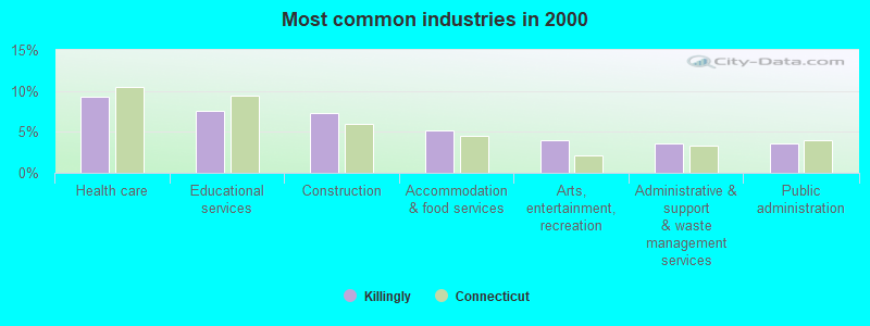
- Health care (9.3%)
- Educational services (7.5%)
- Construction (7.3%)
- Accommodation & food services (5.2%)
- Arts, entertainment, recreation (3.9%)
- Administrative & support & waste management services (3.6%)
- Public administration (3.6%)
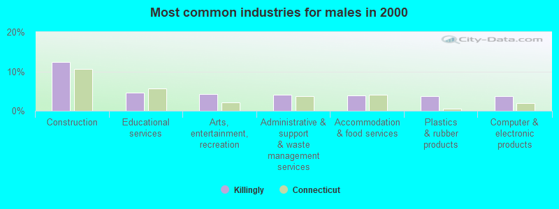
- Construction (12.5%)
- Educational services (4.6%)
- Arts, entertainment, recreation (4.2%)
- Administrative & support & waste management services (4.0%)
- Accommodation & food services (4.0%)
- Plastics & rubber products (3.8%)
- Computer & electronic products (3.7%)
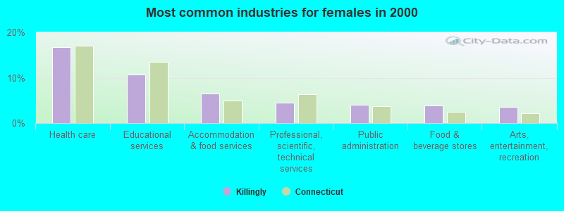
- Health care (16.7%)
- Educational services (10.7%)
- Accommodation & food services (6.5%)
- Professional, scientific, technical services (4.6%)
- Public administration (4.0%)
- Food & beverage stores (3.8%)
- Arts, entertainment, recreation (3.6%)
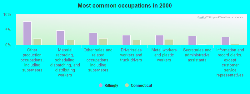
- Other production occupations, including supervisors (7.7%)
- Material recording, scheduling, dispatching, and distributing workers (4.8%)
- Other sales and related occupations, including supervisors (4.0%)
- Driver/sales workers and truck drivers (3.2%)
- Metal workers and plastic workers (3.2%)
- Secretaries and administrative assistants (3.0%)
- Information and record clerks, except customer service representatives (2.7%)
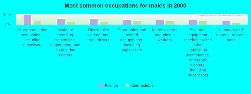
- Other production occupations, including supervisors (9.5%)
- Material recording, scheduling, dispatching, and distributing workers (6.0%)
- Driver/sales workers and truck drivers (6.0%)
- Other sales and related occupations, including supervisors (5.1%)
- Metal workers and plastic workers (4.7%)
- Electrical equipment mechanics and other installation, maintenance, and repair workers, including supervisors (4.7%)
- Laborers and material movers, hand (3.7%)
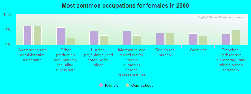
- Secretaries and administrative assistants (6.2%)
- Other production occupations, including supervisors (5.8%)
- Nursing, psychiatric, and home health aides (4.7%)
- Information and record clerks, except customer service representatives (4.6%)
- Registered nurses (3.9%)
- Cashiers (3.8%)
- Preschool, kindergarten, elementary, and middle school teachers (3.5%)
Average climate in Killingly, Connecticut
Based on data reported by over 4,000 weather stations


(lower is better)
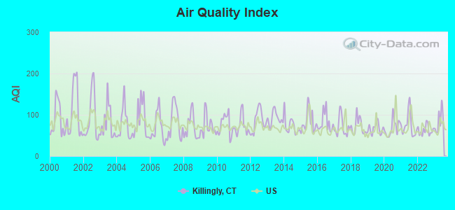
Air Quality Index (AQI) level in 2023 was 84.2. This is about average.
| City: | 84.2 |
| U.S.: | 72.6 |
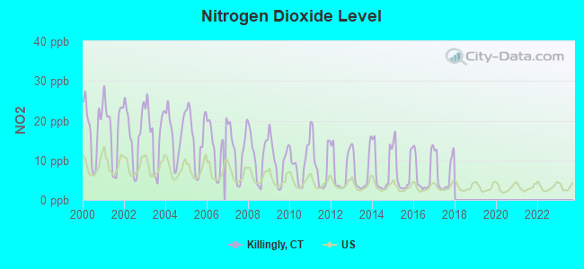
Nitrogen Dioxide (NO2) [ppb] level in 2017 was 6.69. This is worse than average. Closest monitor was 7.3 miles away from the city center.
| City: | 6.69 |
| U.S.: | 5.11 |
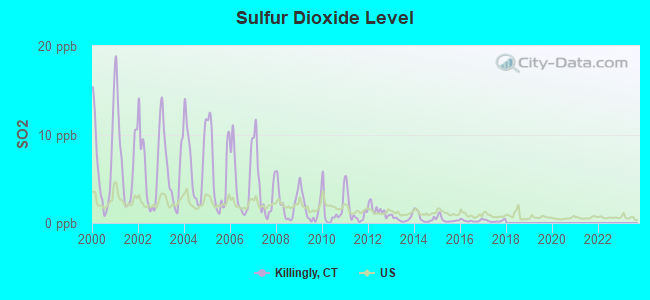
Sulfur Dioxide (SO2) [ppb] level in 2017 was 0.240. This is significantly better than average. Closest monitor was 7.3 miles away from the city center.
| City: | 0.240 |
| U.S.: | 1.515 |
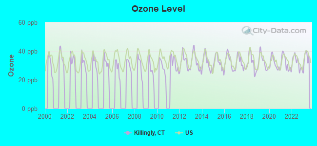
Ozone [ppb] level in 2023 was 34.7. This is about average. Closest monitor was 7.5 miles away from the city center.
| City: | 34.7 |
| U.S.: | 33.3 |
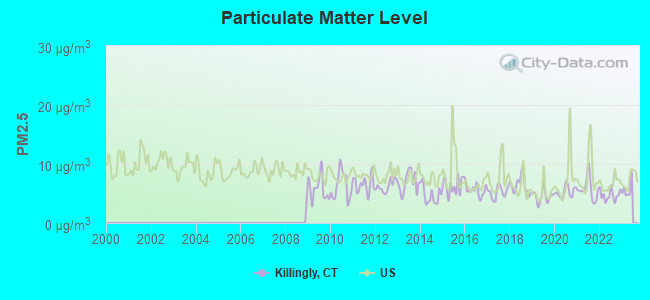
Particulate Matter (PM2.5) [µg/m3] level in 2022 was 4.71. This is significantly better than average. Closest monitor was 11.5 miles away from the city center.
| City: | 4.71 |
| U.S.: | 8.11 |
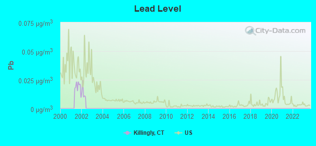
Lead (Pb) [µg/m3] level in 2001 was 0.0187. This is significantly worse than average. Closest monitor was 7.3 miles away from the city center.
| City: | 0.0187 |
| U.S.: | 0.0093 |
Tornado activity:
Killingly-area historical tornado activity is near Connecticut state average. It is 34% smaller than the overall U.S. average.
On 6/9/1953, a category F4 (max. wind speeds 207-260 mph) tornado 37.4 miles away from the Killingly town center killed 90 people and injured 1228 people and caused between $50,000,000 and $500,000,000 in damages.
On 10/3/1979, a category F4 tornado 42.0 miles away from the town center killed 3 people and injured 500 people and caused between $50,000,000 and $500,000,000 in damages.
Earthquake activity:
Killingly-area historical earthquake activity is significantly above Connecticut state average. It is 72% smaller than the overall U.S. average.On 10/7/1983 at 10:18:46, a magnitude 5.3 (5.1 MB, 5.3 LG, 5.1 ML, Class: Moderate, Intensity: VI - VII) earthquake occurred 193.8 miles away from the city center
On 4/20/2002 at 10:50:47, a magnitude 5.3 (5.3 ML, Depth: 3.0 mi) earthquake occurred 207.9 miles away from Killingly center
On 4/20/2002 at 10:50:47, a magnitude 5.2 (5.2 MB, 4.2 MS, 5.2 MW, 5.0 MW) earthquake occurred 206.8 miles away from Killingly center
On 1/19/1982 at 00:14:42, a magnitude 4.7 (4.5 MB, 4.7 MD, 4.5 LG, Class: Light, Intensity: IV - V) earthquake occurred 116.8 miles away from Killingly center
On 10/16/2012 at 23:12:25, a magnitude 4.7 (4.7 ML, Depth: 10.0 mi) earthquake occurred 137.2 miles away from Killingly center
On 8/22/1992 at 12:20:32, a magnitude 4.8 (4.8 MB, 3.8 MS, 4.7 LG, Depth: 6.2 mi) earthquake occurred 204.6 miles away from Killingly center
Magnitude types: regional Lg-wave magnitude (LG), body-wave magnitude (MB), duration magnitude (MD), local magnitude (ML), surface-wave magnitude (MS), moment magnitude (MW)
Natural disasters:
The number of natural disasters in Windham County (24) is greater than the US average (15).Major Disasters (Presidential) Declared: 13
Emergencies Declared: 11
Causes of natural disasters: Hurricanes: 6, Storms: 6, Floods: 4, Snowstorms: 4, Blizzards: 3, Snows: 3, Winter Storms: 3, Snowfall: 1, Tropical Storm: 1, Wind: 1, Other: 1 (Note: some incidents may be assigned to more than one category).
Hospitals and medical centers near Killingly:
- REGENCY HEIGHTS OF DANIELSON, LLC (Nursing Home, about 2 miles away; DANIELSON, CT)
- WESTVIEW NURSING CARE AND REHAB (Nursing Home, about 5 miles away; DAYVILLE, CT)
- PIERCE MEM BAPTIST HOME (Nursing Home, about 6 miles away; BROOKLYN, CT)
- DAY KIMBALL HOSPITAL Acute Care Hospitals (about 7 miles away; PUTNAM, CT)
- NANCY ANN NURSING HOME, INC. (Nursing Home, about 7 miles away; FOSTER, RI)
- HOLY SPIRIT HEALTH CARE INC (Nursing Home, about 8 miles away; PUTNAM, CT)
- MATULAITIS NURSING HOME (Nursing Home, about 8 miles away; PUTNAM, CT)
Colleges/universities with over 2000 students nearest to Killingly:
- Bryant University (about 18 miles; Smithfield, RI; Full-time enrollment: 3,440)
- Eastern Connecticut State University (about 20 miles; Willimantic, CT; FT enrollment: 4,985)
- University of Connecticut (about 21 miles; Storrs, CT; FT enrollment: 22,037)
- Rhode Island College (about 21 miles; Providence, RI; FT enrollment: 7,189)
- Community College of Rhode Island (about 21 miles; Warwick, RI; FT enrollment: 10,500)
- New England Institute of Technology (about 22 miles; East Greenwich, RI; FT enrollment: 3,183)
- Providence College (about 22 miles; Providence, RI; FT enrollment: 4,312)
Private high school in Killingly:
- NEW HOPE ACADEMY (Students: 20, Location: 1369 HARTFORD TPKE, Grades: KG-11)
Points of interest:
Notable locations in Killingly: Quinebaug Valley Emergency Dispatch (A), Williamsville Fire Engine Company Station 60 (B), Quinebaug Valley Community-Technical College Library (C), Killingly Public Library (D), East Killingly Fire Department Station 64 (E), Dayville Fire Department Station 63 (F), Attawaugan Station 62 (G), Killingly - Brooklyn Ambulance Corps (H), Danielson Fire Department Station 61 (I), South Killingly Fire Department Station 65 (J), Killingly Fire Marshal's Office (K). Display/hide their locations on the map
Shopping Centers: Killingly Shopping Center (1), Brooklyn Common Shopping Center (2). Display/hide their locations on the map
Churches in Killingly include: Baptist Church of Danielson (A), Beth Israel Temple (B), Church of the Living God (C), Colonial Baptist Church (D), Danielson United Methodist Church (E), First Apostolic Church (F), Holy Trinity Greek Orthodox Church (G), Kingdom Hall of Jehovahs Witnesses (H), Saint Albans Episcopal Church (I). Display/hide their locations on the map
Cemeteries: Saint Joseph Cemetery (1), Day Cemetery (2), Harrington Cemetery (3), Brainard Cemetery (4), Hutchins Street Cemetery (5), Fiske Cemetery (6), High Saint Cemetery (7). Display/hide their locations on the map
Lakes and reservoirs: Tetreault Pond (A), Wheatons Pond (B), Smith Pond (C), Acme Pond (D), Alexander Lake (E), Quinebaug Pond (F), Ross Pond (G), Alvia Chase Reservoir (H). Display/hide their locations on the map
Streams, rivers, and creeks: Long Brook (A), Mashentuck Brook (B), Norton Brook (C), Phillips Brook (D), Quandock Brook (E), Salisbury Brook (F), Slater Brook (G), Attawaugan Brook (H), Whetstone Brook (I). Display/hide their locations on the map
Parks in Killingly include: Old Furnace State Park (1), Davis Park (2), Dayville Historic District (3), Killingly Pond State Park Reserve (4), Lions Park (5). Display/hide their locations on the map
Birthplace of: Charles Lewis Tiffany - Jewelry businessman, Manasseh Cutler - Politician, William Gaston (Massachusetts) - Politician, William Shadrach Knox - Politician, William Torrey Harris - Lexicographer.
| This town: | 2.5 people |
| Connecticut: | 2.5 people |
| This town: | 67.1% |
| Whole state: | 66.3% |
| This town: | 10.4% |
| Whole state: | 6.6% |
Likely homosexual households (counted as self-reported same-sex unmarried-partner households)
- Lesbian couples: 0.6% of all households
- Gay men: 0.3% of all households
| This town: | 8.7% |
| Whole state: | 7.9% |
| This town: | 4.3% |
| Whole state: | 3.9% |
People in group quarters in Killingly in 2010:
- 262 people in nursing facilities/skilled-nursing facilities
- 54 people in group homes intended for adults
- 34 people in other noninstitutional facilities
- 17 people in emergency and transitional shelters (with sleeping facilities) for people experiencing homelessness
- 7 people in group homes for juveniles (non-correctional)
People in group quarters in Killingly in 2000:
- 260 people in nursing homes
- 93 people in other noninstitutional group quarters
- 25 people in homes for the mentally retarded
- 8 people in homes for abused, dependent, and neglected children
- 6 people in homes for the mentally ill
- 2 people in religious group quarters
For population 15 years and over in Killingly:
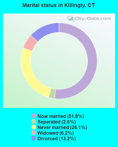
- Never married: 26.1%
- Now married: 51.8%
- Separated: 2.6%
- Widowed: 6.2%
- Divorced: 13.2%
For population 25 years and over in Killingly:
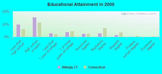
- High school or higher: 75.2%
- Bachelor's degree or higher: 12.7%
- Graduate or professional degree: 5.2%
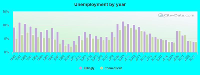
- Unemployed: 5.7%
- Mean travel time to work (commute): 23.9 minutes
| Here: | 11.2 |
| Connecticut average: | 12.8 |
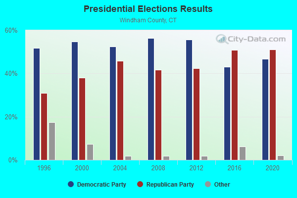
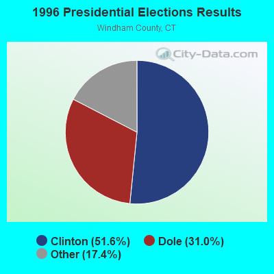
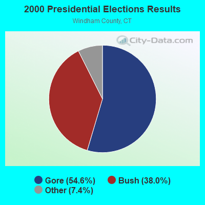
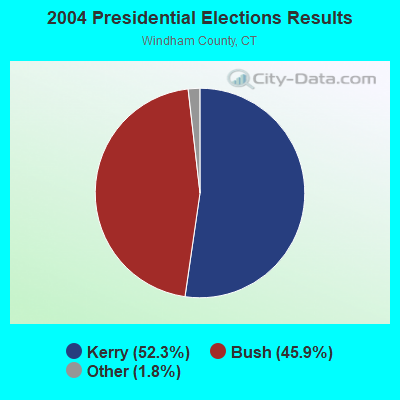
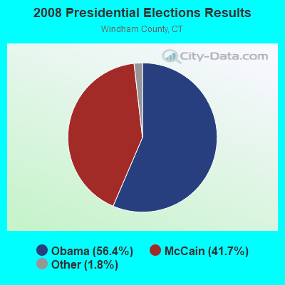

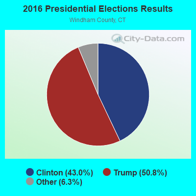
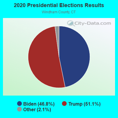
Graphs represent county-level data. Detailed 2008 Election Results
Religion statistics for Killingly, CT (based on Windham County data)
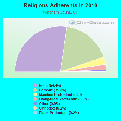
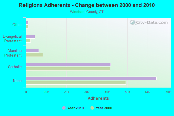
| Religion | Adherents | Congregations |
|---|---|---|
| Catholic | 41,700 | 18 |
| Mainline Protestant | 6,330 | 39 |
| Evangelical Protestant | 4,495 | 37 |
| Other | 1,119 | 12 |
| Orthodox | 205 | 2 |
| Black Protestant | 180 | 1 |
| None | 64,399 | - |
Food Environment Statistics:
| Windham County: | 1.63 / 10,000 pop. |
| Connecticut: | 2.21 / 10,000 pop. |
| Windham County: | 0.17 / 10,000 pop. |
| Connecticut: | 0.07 / 10,000 pop. |
| This county: | 1.11 / 10,000 pop. |
| Connecticut: | 1.02 / 10,000 pop. |
| Windham County: | 3.08 / 10,000 pop. |
| Connecticut: | 2.27 / 10,000 pop. |
| Windham County: | 6.76 / 10,000 pop. |
| Connecticut: | 9.19 / 10,000 pop. |
| Windham County: | 8.0% |
| State: | 7.3% |
| Windham County: | 26.6% |
| Connecticut: | 21.5% |
| Windham County: | 18.7% |
| Connecticut: | 15.8% |
| Businesses in Killingly, CT | ||||
| Name | Count | Name | Count | |
|---|---|---|---|---|
| Dunkin Donuts | 1 | Staples | 1 | |
| GNC | 1 | Stop & Shop | 1 | |
| McDonald's | 1 | |||
Strongest AM radio stations in Killingly:
- WALE (990 AM; 50 kW; GREENVILLE, RI; Owner: NORTH AMERICAN BROADCASTING CO., INC.)
- WINY (1350 AM; 5 kW; PUTNAM, CT; Owner: OSBREY BROADCASTING COMPANY)
- WCRN (830 AM; 50 kW; WORCESTER, MA; Owner: CARTER BROADCASTING CORPORATION)
- WVNE (760 AM; daytime; 25 kW; LEICESTER, MA; Owner: BLOUNT MASSCOM, INC.)
- WEEI (850 AM; 50 kW; BOSTON, MA; Owner: ENTERCOM BOSTON LICENSE, LLC)
- WKOX (1200 AM; 50 kW; FRAMINGHAM, MA; Owner: CAPSTAR TX LIMITED PARTNERSHIP)
- WNNZ (640 AM; 50 kW; WESTFIELD, MA; Owner: CLEAR CHANNEL BROADCASTING LICENSES, INC.)
- WBIX (1060 AM; 40 kW; NATICK, MA; Owner: LANGER BROADCASTING CORPORATION)
- WRKO (680 AM; 50 kW; BOSTON, MA; Owner: ENTERCOM BOSTON LICENSE, LLC)
- WAMG (890 AM; 25 kW; DEDHAM, MA; Owner: MEGA COMMUNICATIONS OF DEDHAM LICENSEE, LLC)
- WTIC (1080 AM; 50 kW; HARTFORD, CT; Owner: INFINITY RADIO OPERATIONS INC.)
- WRNI (1290 AM; 10 kW; PROVIDENCE, RI; Owner: WRNI FOUNDATION)
- WBZ (1030 AM; 50 kW; BOSTON, MA; Owner: INFINITY BROADCASTING OPERATIONS, INC.)
Strongest FM radio stations in Killingly:
- WBVC (91.1 FM; POMFRET, CT; Owner: POMFRET SCHOOL)
- WWRX-FM (103.7 FM; WESTERLY, RI; Owner: FNX BROADCASTING OF RHODE ISLAND, LLC)
- WWFX (100.1 FM; SOUTHBRIDGE, MA; Owner: CITADEL BROADCASTING COMPANY)
- WWBB (101.5 FM; PROVIDENCE, RI; Owner: CLEAR CHANNEL BROADCASTING LICENSES, INC.)
- WAAF (107.3 FM; WORCESTER, MA; Owner: ENTERCOM BOSTON LICENSE, LLC)
- WPRO-FM (92.3 FM; PROVIDENCE, RI; Owner: CITADEL BROADCASTING COMPANY)
- WORC-FM (98.9 FM; WEBSTER, MA; Owner: CITADEL BROADCASTING COMPANY)
- WWKX (106.3 FM; WOONSOCKET, RI; Owner: AAA ENTERTAINMENT LICENSING LLC)
- WSKO-FM (99.7 FM; WAKEFIELD-PEACEDALE, RI; Owner: CITADEL BROADCASTING COMPANY)
- WILI-FM (98.3 FM; WILLIMANTIC, CT; Owner: NUTMEG BROADCASTING COMPANY)
- WWLI (105.1 FM; PROVIDENCE, RI; Owner: CITADEL BROADCASTING COMPANY)
- WHUS (91.7 FM; STORRS, CT; Owner: THE BD. OF TRUSTEES, THE UNIV. OF CT)
- WSRS (96.1 FM; WORCESTER, MA; Owner: CAPSTAR TX LIMITED PARTNERSHIP)
- WBMX (98.5 FM; BOSTON, MA; Owner: INFINITY RADIO OPERATIONS INC.)
- WJMN (94.5 FM; BOSTON, MA; Owner: AMFM RADIO LICENSES, L.L.C.)
- WBOS (92.9 FM; BROOKLINE, MA; Owner: GREATER BOSTON RADIO, INC.)
- WCRB (102.5 FM; WALTHAM, MA; Owner: CHARLES RIVER BROADCASTING WCRB LICE)
- WTKK (96.9 FM; BOSTON, MA; Owner: GREATER BOSTON RADIO, INC.)
- WSNE-FM (93.3 FM; TAUNTON, MA; Owner: CAPSTAR TX LIMITED PARTNERSHIP)
- WROR-FM (105.7 FM; FRAMINGHAM, MA; Owner: GREATER BOSTON RADIO, INC.)
TV broadcast stations around Killingly:
- WPXQ (Channel 69; BLOCK ISLAND, RI; Owner: OCEAN STATE TELEVISION, L.L.C.)
- WYDN (Channel 48; WORCESTER, MA; Owner: EDUCATIONAL PUBLIC TV CORPORATION)
- WRIW-LP (Channel 50; PROVIDENCE, RI; Owner: ZGS PROVIDENCE, INC.)
- WHPX (Channel 26; NEW LONDON, CT; Owner: PAXSON HARTFORD LICENSE, INC.)
- WUNI (Channel 27; WORCESTER, MA; Owner: ENTRAVISION HOLDINGS, LLC)
- WNAC-TV (Channel 64; PROVIDENCE, RI; Owner: WNAC, LLC)
- WPRI-TV (Channel 12; PROVIDENCE, RI; Owner: TVL BROADCASTING OF RHODE ISLAND, LLC)
- WCVB-TV (Channel 5; BOSTON, MA; Owner: WCVB HEARST-ARGYLE TV, INC.)
- WGBH-TV (Channel 2; BOSTON, MA; Owner: WGBH EDUCATIONAL FOUNDATION)
- WJAR (Channel 10; PROVIDENCE, RI; Owner: OUTLET BROADCASTING, INC.)
- WLNE-TV (Channel 6; NEW BEDFORD, MA; Owner: FREEDOM BROADCASTING OF SOUTHERN NEW ENGLAND, INC.)
- WTIC-TV (Channel 61; HARTFORD, CT; Owner: TRIBUNE TELEVISION COMPANY)
- WSBE-TV (Channel 36; PROVIDENCE, RI; Owner: RHODE ISLAND PUBLIC TELECOM. AUTHORITY)
- WUTF (Channel 66; MARLBOROUGH, MA; Owner: TELEFUTURA BOSTON LLC)
- WMFP (Channel 62; LAWRENCE, MA; Owner: WSAH LICENSE, INC.)
- WSBK-TV (Channel 38; BOSTON, MA; Owner: VIACOM INC.)
- WBZ-TV (Channel 4; BOSTON, MA; Owner: VIACOM INC.)
- WGBX-TV (Channel 44; BOSTON, MA; Owner: WGBH EDUCATIONAL FOUNDATION)
- WLVI-TV (Channel 56; CAMBRIDGE, MA; Owner: WLVI, INC.)
- WFXT (Channel 25; BOSTON, MA; Owner: FOX TELEVISION STATIONS INC.)
- WTXX (Channel 20; WATERBURY, CT; Owner: WTXX INC.)
- WWDP (Channel 46; NORWELL, MA; Owner: NORWELL TELEVISION, LLC)
- WEDN (Channel 53; NORWICH, CT; Owner: CONNECTICUT PUBLIC BROADCASTING, INC.)
Medal of Honor Recipients
Medal of Honor Recipient born in Killingly: Edward W. Whitaker.
- National Bridge Inventory (NBI) Statistics
- 81Number of bridges
- 581ft / 177mTotal length
- 757,177Total average daily traffic
- 72,358Total average daily truck traffic
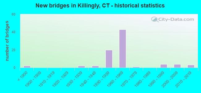
- New bridges - historical statistics
- 2Before 1900
- 21930-1939
- 21940-1949
- 201950-1959
- 431960-1969
- 11970-1979
- 41990-1999
- 42000-2009
- 32010-2019
FCC Registered Antenna Towers:
21 (See the full list of FCC Registered Antenna Towers in Killingly)FCC Registered Broadcast Land Mobile Towers:
5- QV KILLINGLY, 812 Providence Pike (Lat: 41.792333 Lon: -71.823417), Type: Mtower, Structure height: 58 m, Call Sign: KDA658,
Assigned Frequencies: 151.430 MHz, Grant Date: 07/24/2023, Expiration Date: 10/18/2033, Registrant: Goosetown Communications Inc, 7 A Old Winsor Road, Bloomfield, CT 06002, Phone: (860) 528-7500, Email:
- Northside Rt 6 1 Mi E Of Rt 6 & Wescott Rd (Lat: 41.792333 Lon: -71.823417), Call Sign: KNJX339, Licensee ID: L00412908,
Assigned Frequencies: 33.7800 MHz, 46.1600 MHz, Grant Date: 06/08/1999, Expiration Date: 08/24/2004, Cancellation Date: 10/30/2004, Registrant: State Of Connecticut, 1111 Country Club Rd, Middletown, CT 06457-9294, Phone: (860) 685-8080
- 173 Mechanic Street (Lat: 41.811278 Lon: -71.883778), Type: Bant, Structure height: 27 m, Overall height: 30.5 m, Call Sign: KCB549,
Assigned Frequencies: 37.4800 MHz, 37.7400 MHz, 37.8000 MHz, 47.7400 MHz, Grant Date: 09/04/2013, Expiration Date: 11/24/2023, Cancellation Date: 01/27/2024, Certifier: Wayne P Hamel, Registrant: Keller And Heckman LLP, 1001 G Street Nw, Suite 500 West, Washington, DC 20001, Phone: (202) 434-4100, Fax: (202) 434-4646, Email:
- DANIELSON WK. CTR., 173 Mechanic Street (Lat: 41.811278 Lon: -71.883778), Type: Bant, Structure height: 27 m, Overall height: 30.5 m, Call Sign: WNMQ336,
Assigned Frequencies: 173.250 MHz, 173.350 MHz, Grant Date: 08/11/2015, Expiration Date: 10/25/2025, Registrant: Keller And Heckman LLP, 1001 G Street, Nw, Suite 500 West, Washington, DC 20001, Phone: (202) 434-4100, Fax: (202) 434-4646, Email:
- DANIELSON WK. CTR., 173 Mechanic Street (Lat: 41.811278 Lon: -71.883778), Type: Bant, Structure height: 27 m, Overall height: 30.5 m, Call Sign: WPIY709,
Assigned Frequencies: 154.463 MHz, Grant Date: 09/12/2015, Expiration Date: 11/30/2025, Certifier: Wayne P Hamel, Registrant: Keller And Heckman LLP, 1001 G Street Nw, Suite 500 West, Washington, DC 20001, Phone: (202) 434-4100, Fax: (202) 434-4646, Email:
FCC Registered Amateur Radio Licenses:
5- Call Sign: N1VIT, Licensee ID: L00338258, Grant Date: 03/23/2005, Expiration Date: 06/09/2015, Cancellation Date: 06/10/2017, Certifier: Albert A Leonard, Registrant: Albert A Leonard, Killingly, CT 06243-0302
- Call Sign: KB1FOX, Licensee ID: L00240369, Grant Date: 08/23/2000, Expiration Date: 08/23/2010, Cancellation Date: 10/03/2000, Certifier: Richard R Pechie, Registrant: The Barnstormers Contest Group, E Killingly, CT 06243
- Call Sign: KB1PWZ, Licensee ID: L01363813, Grant Date: 07/17/2018, Expiration Date: 07/17/2028, Certifier: James E Trudell Iii, Registrant: James E Trudell Iii, 207 Cranberry Bog Rd, Killingly, CT 06239
- Call Sign: KN4PMG, Licensee ID: L02218155, Grant Date: 10/10/2018, Expiration Date: 10/10/2028, Cancellation Date: 03/26/2019, Certifier: Robert R Runge, Registrant: Robert R Runge, 702 Whetstone Mills, Killingly, CT 06241
- Call Sign: W1LSZ, Previous Call Sign: KN4PMG, Licensee ID: L02218155, Grant Date: 03/26/2019, Expiration Date: 03/26/2029, Certifier: Robert R Runge, Registrant: Robert R Runge, 702 Whetstone Mills, Killingly, CT 06241
2002 - 2018 National Fire Incident Reporting System (NFIRS) incidents
- Fire incident types reported to NFIRS in Killingly, CT
- 8873.9%Structure Fires
- 1916.0%Outside Fires
- 86.7%Mobile Property/Vehicle Fires
- 43.4%Other
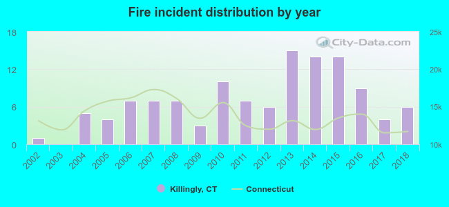 Based on the data from the years 2002 - 2018 the average number of fire incidents per year is 7. The highest number of fires - 15 took place in 2013, and the least - 0 in 2003. The data has an increasing trend.
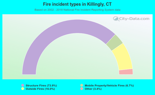 When looking into fire subcategories, the most incidents belonged to: Structure Fires (73.9%), and Outside Fires (16.0%).
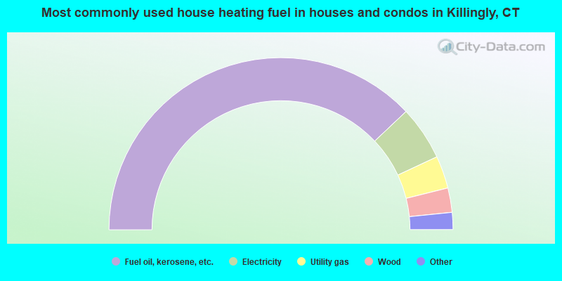
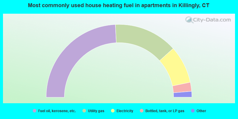
- 75.9%Fuel oil, kerosene, etc.
- 10.2%Electricity
- 6.1%Utility gas
- 4.6%Wood
- 2.7%Bottled, tank, or LP gas
- 0.4%Coal or coke
- 0.1%Other fuel
- 48.4%Fuel oil, kerosene, etc.
- 28.2%Utility gas
- 16.7%Electricity
- 4.0%Bottled, tank, or LP gas
- 1.7%Wood
- 0.9%No fuel used
Killingly compared to Connecticut state average:
- Unemployed percentage below state average.
- Black race population percentage significantly below state average.
- Hispanic race population percentage significantly below state average.
- Foreign-born population percentage significantly below state average.
- Length of stay since moving in significantly above state average.
- Number of rooms per house significantly below state average.
- House age significantly below state average.
- Number of college students below state average.
- Percentage of population with a bachelor's degree or higher significantly below state average.
Killingly on our top lists:
- #3 on the list of "Top 101 cities with largest percentage of females in industries: office supplies and stationery stores (population 5,000+)"
- #5 on the list of "Top 101 cities with largest percentage of males in industries: office supplies and stationery stores (population 5,000+)"
- #28 on the list of "Top 101 cities with largest percentage of males in occupations: material recording, scheduling, dispatching, and distributing workers (population 5,000+)"
- #29 on the list of "Top 101 cities with largest percentage of males in industries: fuel dealers (population 5,000+)"
- #33 on the list of "Top 101 cities with largest percentage of females in occupations: material moving workers except supervisors and laborers and material movers, hand (population 5,000+)"
- #34 on the list of "Top 101 cities with largest percentage of females in industries: groceries and related products merchant wholesalers (population 5,000+)"
- #35 on the list of "Top 101 cities with largest percentage of males in industries: plastics and rubber products (population 5,000+)"
- #39 on the list of "Top 101 cities with largest percentage of females in occupations: pipelayers, plumbers, pipefitters, and steamfitters (population 5,000+)"
- #42 on the list of "Top 101 cities with largest percentage of females in industries: food (population 5,000+)"
- #42 on the list of "Top 101 cities with largest percentage of females in industries: metal and metal products (population 5,000+)"
- #44 on the list of "Top 101 cities with largest percentage of males in occupations: supervisors and other personal care and service workers except personal appearance, transportation, and child care workers (population 5,000+)"
- #51 on the list of "Top 101 cities with largest percentage of females in industries: plastics and rubber products (population 5,000+)"
- #52 on the list of "Top 101 cities with largest percentage of males in occupations: personal appearance workers (population 5,000+)"
- #57 on the list of "Top 101 cities with largest percentage of males in industries: food (population 5,000+)"
- #73 on the list of "Top 101 cities with largest percentage of females in occupations: judges, magistrates, and other judicial workers (population 5,000+)"
- #74 on the list of "Top 101 cities with the most residents born in United Kingdom (population 500+)"
- #74 on the list of "Top 101 cities with the most residents born in Yugoslavia (population 500+)"
- #74 on the list of "Top 101 cities with the most residents born in Asia, n.e.c. (population 500+)"
- #74 on the list of "Top 101 cities with the most residents born in Melanesia (population 500+)"
- #74 on the list of "Top 101 cities with the most residents born in Micronesia (population 500+)"
- #52 (06239) on the list of "Top 101 zip codes with the largest percentage of French Canadian first ancestries (pop 5,000+)"
- #43 on the list of "Top 101 counties with the lowest total withdrawal of fresh water for public supply (pop. 50,000+)"
- #44 on the list of "Top 101 counties with the lowest surface withdrawal of fresh water for public supply (pop. 50,000+)"
- #60 on the list of "Top 101 counties with the lowest number of births per 1000 residents 2007-2013"
- #65 on the list of "Top 101 counties with highest percentage of residents voting for Obama (Democrat) in the 2012 Presidential Election"
- #95 on the list of "Top 101 counties with the largest decrease in the number of deaths per 1000 residents 2000-2006 to 2007-2013 (pop. 50,000+)"

|
Total of 5 patent applications in 2008-2024.