Foster, Rhode Island
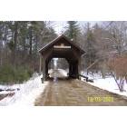
Foster: Foster Covered Brige
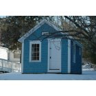
Foster: The Old Jail
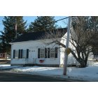
Foster: Benjamin Eddy Building
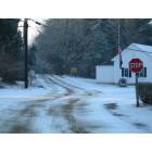
Foster: DOWNTOWN OLD FOSTER
- add
your


Submit your own pictures of this town and show them to the world
- OSM Map
- General Map
- Google Map
- MSN Map
Population change since 2000: +7.8%
 |
| Males: 2,323 | |
| Females: 2,283 |
| Median resident age: | 44.8 years |
| Rhode Island median age: | 42.3 years |
Zip codes: 02825.
| Foster: | $121,596 |
| RI: | $81,854 |
Estimated per capita income in 2022: $45,475 (it was $22,148 in 2000)
Foster town income, earnings, and wages data
Estimated median house or condo value in 2022: $465,443 (it was $157,600 in 2000)
| Foster: | $465,443 |
| RI: | $383,900 |
Mean prices in 2022: all housing units: $374,091; detached houses: $391,079; townhouses or other attached units: $339,877; in 2-unit structures: $329,737; in 3-to-4-unit structures: $340,395; in 5-or-more-unit structures: $281,172; mobile homes: $172,414
Detailed information about poverty and poor residents in Foster, RI


Compare current foreclosures near Foster, RI:
| Photo | Address | Area | Beds / Baths | Price | Details |
|---|---|---|---|---|---|

|
#1
Hicks Way
Foster, RI 02825
|
2,240 sq. feet
|
3 baths 4 beds |
show details | |

|
#2
Azalea Ct
Foster, RI 02825
|
- sq. feet
|
- baths - beds |
show details | |

|
#3
Round Lake Dr
Pascoag, RI 02859
|
976 sq. feet
|
2 baths 2 beds |
$179,900
|
show details |

|
#4
Mount Pleasant Rd
Harrisville, RI 02830
|
1,232 sq. feet
|
1 baths 3 beds |
$449,900
|
show details |

|
#5
N Society Rd
Canterbury, CT 06331
|
768 sq. feet
|
1 baths 2 beds |
$269,900
|
show details |

|
#6
Whittier Ave
Providence, RI 02909
|
3 sq. feet
|
3 baths 6 beds |
$109,900
|
show details |

|
#7
Knotty Oak Rd
Coventry, RI 02816
|
1,080 sq. feet
|
1 baths 2 beds |
show details | |

|
#8
N Main St
Pascoag, RI 02859
|
- sq. feet
|
- baths - beds |
$100,000
|
show details |

|
#9
Guertin St
West Warwick, RI 02893
|
1,338 sq. feet
|
2 baths 4 beds |
show details | |

|
#10
Atwood Ave
Johnston, RI 02919
|
1,792 sq. feet
|
2 baths 4 beds |
show details |
| Photo | Address | Area | Beds / Baths | Price | Details |
|---|---|---|---|---|---|

|
#11
Atwood Ave
Johnston, RI 02919
|
1,792 sq. feet
|
1 baths 4 beds |
show details | |

|
#12
Allard St
Cranston, RI 02920
|
828 sq. feet
|
1 baths 2 beds |
show details | |

|
#13
Cynthia Dr Apt 13
North Providence, RI 02911
|
768 sq. feet
|
1 baths 2 beds |
show details | |

|
#14
Bracken St
Cranston, RI 02920
|
1,248 sq. feet
|
1 baths 4 beds |
show details | |

|
#15
Round Top Rd
Harrisville, RI 02830
|
1,280 sq. feet
|
1 baths 3 beds |
show details | |

|
#16
Boys Ave
Rogers, CT 06263
|
- sq. feet
|
2 baths 6 beds |
show details | |

|
#17
Wood St
Providence, RI 02909
|
2,839 sq. feet
|
3 baths 8 beds |
show details | |

|
#18
Linwood Ave
Providence, RI 02907
|
1,614 sq. feet
|
1 baths 3 beds |
show details | |

|
#19
Spooner Ave
Warwick, RI 02886
|
1,777 sq. feet
|
2 baths 4 beds |
show details | |

|
#20
Woburn St
Cranston, RI 02910
|
1,212 sq. feet
|
1 baths 4 beds |
show details |
| Photo | Address | Area | Beds / Baths | Price | Details |
|---|---|---|---|---|---|

|
#21
Tyndall Ave
Providence, RI 02908
|
1,523 sq. feet
|
1 baths 4 beds |
show details | |

|
#22
Valley Green Court
Providence, RI 02904
|
1,440 sq. feet
|
3 baths 2 beds |
show details | |

|
#23
Branch Ave
Providence, RI 02904
|
2,921 sq. feet
|
4 baths 6 beds |
show details | |

|
#24
Mulberry Ct
Coventry, RI 02816
|
1,176 sq. feet
|
1 baths 2 beds |
show details | |

|
#25
Pinnery Ave
Warwick, RI 02886
|
1,299 sq. feet
|
1 baths 3 beds |
show details | |

|
#26
Peckham Ln
Coventry, RI 02816
|
2,623 sq. feet
|
3 baths 3 beds |
show details | |

|
#27
Squaw Rock Rd
Moosup, CT 06354
|
1,732 sq. feet
|
2 baths 3 beds |
show details | |

|
#28
Pawtucket Ave
Chepachet, RI 02814
|
275 sq. feet
|
1 baths 2 beds |
show details | |

|
#29
Brooklyn Rd
Pomfret Center, CT 06259
|
1,951 sq. feet
|
1 baths 4 beds |
show details | |

|
#30
Quaker Ln Apt 31
West Warwick, RI 02893
|
1,288 sq. feet
|
1 baths 2 beds |
show details |
| Photo | Address | Area | Beds / Baths | Price | Details |
|---|---|---|---|---|---|

|
#31
Quaker Ln Apt 42
West Warwick, RI 02893
|
1,140 sq. feet
|
1 baths 2 beds |
show details | |

|
#32
Lucy St
Providence, RI 02909
|
1,109 sq. feet
|
1 baths 4 beds |
show details | |

|
#33
E Greenwich Ave, Bldg 2
West Warwick, RI 02893
|
1,264 sq. feet
|
2 baths 2 beds |
show details | |

|
#34
E Lakeview Dr
Providence, RI 02904
|
1,584 sq. feet
|
2 baths 3 beds |
show details | |

|
#35
Worcester Ave
North Providence, RI 02911
|
1,680 sq. feet
|
1 baths 3 beds |
show details | |

|
#36
Westcott Ave
Cranston, RI 02910
|
1,340 sq. feet
|
1 baths 3 beds |
show details | |

|
#37
Lake View Dr
Chepachet, RI 02814
|
1,370 sq. feet
|
1 baths 2 beds |
show details | |

|
#38
Norwich Rd
Plainfield, CT 06374
|
2,161 sq. feet
|
1 baths 3 beds |
show details | |

|
#39
Weston Ave
Cranston, RI 02920
|
2,378 sq. feet
|
2 baths 4 beds |
show details | |

|
#40
Whipple Ave
Cranston, RI 02920
|
2,233 sq. feet
|
2 baths 6 beds |
show details |
| Photo | Address | Area | Beds / Baths | Price | Details |
|---|---|---|---|---|---|

|
#41
Colleen St
Danielson, CT 06239
|
1,714 sq. feet
|
1 baths 3 beds |
show details | |

|
#42
Mongenais St
Providence, RI 02909
|
2,684 sq. feet
|
3 baths 6 beds |
show details | |

|
#43
Roslyn Ave
Cranston, RI 02910
|
1,352 sq. feet
|
1 baths 3 beds |
show details | |

|
#44
Bellevue Ave
North Providence, RI 02911
|
1,980 sq. feet
|
3 baths 5 beds |
show details | |

|
#45
Lowell St
Cranston, RI 02910
|
1,389 sq. feet
|
1 baths 2 beds |
show details | |

|
#46
Hawthorne Pl # 12
Providence, RI 02904
|
1,280 sq. feet
|
1 baths 2 beds |
show details | |

|
#47
Metropolitan Rd
Providence, RI 02908
|
816 sq. feet
|
1 baths 2 beds |
show details | |

|
#48
Wendell St
North Providence, RI 02911
|
1,008 sq. feet
|
1 baths 3 beds |
show details | |

|
#49
Plantation St
Warwick, RI 02886
|
1,296 sq. feet
|
1 baths 3 beds |
show details | |

|
Check over 1 million property listings on Foreclosure.com!
|
browse all offers | |||

- 4,41695.9%White alone
- 581.3%Hispanic
- 441.0%Asian alone
- 471.0%Two or more races
- 290.6%Black alone
- 120.3%American Indian alone
Races in Foster detailed stats: ancestries, foreign born residents, place of birth
According to our research of Rhode Island and other state lists, there were 5 registered sex offenders living in Foster, Rhode Island as of May 09, 2024.
The ratio of all residents to sex offenders in Foster is 921 to 1.
The ratio of registered sex offenders to all residents in this city is near the state average.
Type |
2009 |
2010 |
2011 |
2012 |
2013 |
2014 |
2015 |
2016 |
2017 |
2018 |
2019 |
2020 |
2021 |
2022 |
|---|---|---|---|---|---|---|---|---|---|---|---|---|---|---|
| Murders (per 100,000) | 0 (0.0) | 0 (0.0) | 0 (0.0) | 0 (0.0) | 0 (0.0) | 0 (0.0) | 0 (0.0) | 0 (0.0) | 0 (0.0) | 0 (0.0) | 0 (0.0) | 0 (0.0) | 0 (0.0) | 0 (0.0) |
| Rapes (per 100,000) | 0 (0.0) | 0 (0.0) | 0 (0.0) | 0 (0.0) | 0 (0.0) | 4 (85.4) | 0 (0.0) | 0 (0.0) | 0 (0.0) | 1 (21.1) | 1 (21.1) | 2 (42.1) | 0 (0.0) | 1 (22.5) |
| Robberies (per 100,000) | 0 (0.0) | 0 (0.0) | 1 (21.7) | 0 (0.0) | 0 (0.0) | 0 (0.0) | 0 (0.0) | 0 (0.0) | 1 (21.1) | 0 (0.0) | 0 (0.0) | 1 (21.1) | 0 (0.0) | 0 (0.0) |
| Assaults (per 100,000) | 4 (88.2) | 0 (0.0) | 1 (21.7) | 4 (86.9) | 3 (64.4) | 7 (149.4) | 2 (42.5) | 5 (106.1) | 6 (126.7) | 5 (105.6) | 2 (42.3) | 4 (84.3) | 2 (40.5) | 6 (134.7) |
| Burglaries (per 100,000) | 20 (440.8) | 20 (434.2) | 21 (456.5) | 17 (369.3) | 19 (407.7) | 14 (298.9) | 7 (148.9) | 17 (360.7) | 13 (274.5) | 13 (274.6) | 9 (190.3) | 8 (168.5) | 4 (81.1) | 2 (44.9) |
| Thefts (per 100,000) | 12 (264.5) | 11 (238.8) | 18 (391.3) | 28 (608.3) | 16 (343.3) | 16 (341.6) | 31 (659.4) | 23 (488.0) | 18 (380.1) | 22 (464.6) | 18 (380.5) | 22 (463.5) | 18 (364.9) | 12 (269.4) |
| Auto thefts (per 100,000) | 1 (22.0) | 2 (43.4) | 0 (0.0) | 3 (65.2) | 3 (64.4) | 2 (42.7) | 0 (0.0) | 0 (0.0) | 1 (21.1) | 4 (84.5) | 0 (0.0) | 3 (63.2) | 3 (60.8) | 1 (22.5) |
| Arson (per 100,000) | 0 (0.0) | 0 (0.0) | 0 (0.0) | 0 (0.0) | 0 (0.0) | 0 (0.0) | 0 (0.0) | 0 (0.0) | 0 (0.0) | 0 (0.0) | 0 (0.0) | 0 (0.0) | 0 (0.0) | 1 (22.5) |
| City-Data.com crime index | 60.8 | 43.4 | 58.5 | 72.8 | 60.3 | 136.2 | 45.3 | 66.0 | 67.8 | 82.6 | 53.9 | 92.3 | 33.2 | 60.6 |
The City-Data.com crime index weighs serious crimes and violent crimes more heavily. Higher means more crime, U.S. average is 246.1. It adjusts for the number of visitors and daily workers commuting into cities.

Crime rate in Foster detailed stats: murders, rapes, robberies, assaults, burglaries, thefts, arson
Full-time law enforcement employees in 2021, including police officers: 9 (6 officers - 5 male; 1 female).
| Officers per 1,000 residents here: | 1.22 |
| Rhode Island average: | 2.27 |
 Recent articles from our blog. Our writers, many of them Ph.D. graduates or candidates, create easy-to-read articles on a wide variety of topics.


 | Top Democrats Flock to One of Whitest and Most Affluent RI Communities (138 replies) |
| 2022 Election: If Ya Can't Win Fair and Square - CHEAT (534 replies) |
| The Bucket (499 replies) |
| Rhode Island is introducing legislation to ban critical race (750 replies) |
| Things I learned on the City-Data Rhode Island forum, that you can't get anywhere else! (75 replies) |
| Rhode Island Weather Discussion (65 replies) |
Latest news from Foster, RI collected exclusively by city-data.com from local newspapers, TV, and radio stations
Ancestries: English (21.7%), Irish (21.3%), Italian (20.2%), French (15.2%), German (8.5%), Polish (7.3%).
Current Local Time: EST time zone
Incorporated in 1781
Elevation: 711 feet
Land area: 51.1 square miles.
Population density: 90 people per square mile (very low).

71 residents are foreign born
| This town: | 1.7% |
| Rhode Island: | 11.4% |
| Foster town: | 1.6% ($2,474) |
| Rhode Island: | 1.9% ($2,507) |
Nearest city with pop. 50,000+: Cranston, RI (14.2 miles  , pop. 79,269).
Nearest city with pop. 200,000+: Boston, MA (48.9 miles , pop. 589,141).
Nearest city with pop. 1,000,000+: Bronx, NY (129.4 miles , pop. 1,332,650).
Nearest cities:
), ), ), ), Latitude: 41.80 N, Longitude: 71.73 W

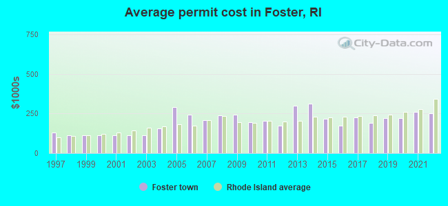
Single-family new house construction building permits:
- 2022: 5 buildings, average cost: $253,300
- 2021: 9 buildings, average cost: $261,100
- 2020: 4 buildings, average cost: $222,100
- 2019: 12 buildings, average cost: $223,100
- 2018: 8 buildings, average cost: $191,000
- 2017: 7 buildings, average cost: $225,900
- 2016: 6 buildings, average cost: $174,300
- 2015: 7 buildings, average cost: $216,800
- 2014: 3 buildings, average cost: $315,100
- 2013: 2 buildings, average cost: $299,400
- 2012: 4 buildings, average cost: $175,800
- 2011: 3 buildings, average cost: $204,200
- 2010: 7 buildings, average cost: $194,000
- 2009: 6 buildings, average cost: $244,200
- 2008: 12 buildings, average cost: $238,000
- 2007: 11 buildings, average cost: $208,900
- 2006: 17 buildings, average cost: $244,000
- 2005: 20 buildings, average cost: $289,700
- 2004: 18 buildings, average cost: $154,600
- 2003: 13 buildings, average cost: $113,400
- 2002: 14 buildings, average cost: $113,400
- 2001: 13 buildings, average cost: $113,400
- 2000: 16 buildings, average cost: $113,600
- 1999: 16 buildings, average cost: $112,400
- 1998: 17 buildings, average cost: $113,200
- 1997: 10 buildings, average cost: $129,700
| Here: | 3.1% |
| Rhode Island: | 3.3% |
- Health care (14.3%)
- Educational services (11.1%)
- Construction (8.8%)
- Public administration (6.4%)
- Professional, scientific, technical services (5.6%)
- Finance & insurance (4.5%)
- Accommodation & food services (3.7%)
- Construction (15.0%)
- Public administration (6.6%)
- Health care (6.5%)
- Educational services (6.3%)
- Professional, scientific, technical services (5.5%)
- Accommodation & food services (4.4%)
- Metal & metal products (3.6%)
- Health care (23.6%)
- Educational services (16.8%)
- Public administration (6.1%)
- Finance & insurance (6.0%)
- Professional, scientific, technical services (5.8%)
- Personal & laundry services (3.8%)
- Social assistance (3.1%)
- Other management occupations, except farmers and farm managers (5.3%)
- Other sales and related occupations, including supervisors (4.3%)
- Other office and administrative support workers, including supervisors (4.1%)
- Preschool, kindergarten, elementary, and middle school teachers (3.9%)
- Counselors, social workers, and other community and social service specialists (3.3%)
- Carpenters (3.1%)
- Building and grounds cleaning and maintenance occupations (3.1%)
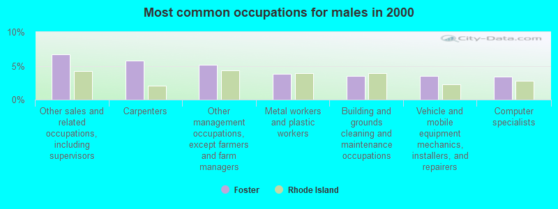
- Other sales and related occupations, including supervisors (6.7%)
- Carpenters (5.8%)
- Other management occupations, except farmers and farm managers (5.1%)
- Metal workers and plastic workers (3.8%)
- Building and grounds cleaning and maintenance occupations (3.5%)
- Vehicle and mobile equipment mechanics, installers, and repairers (3.5%)
- Computer specialists (3.4%)

- Preschool, kindergarten, elementary, and middle school teachers (8.5%)
- Secretaries and administrative assistants (6.3%)
- Other office and administrative support workers, including supervisors (6.2%)
- Nursing, psychiatric, and home health aides (6.0%)
- Other management occupations, except farmers and farm managers (5.5%)
- Counselors, social workers, and other community and social service specialists (5.0%)
- Registered nurses (4.6%)
Average climate in Foster, Rhode Island
Based on data reported by over 4,000 weather stations


(lower is better)

Air Quality Index (AQI) level in 2023 was 84.3. This is about average.
| City: | 84.3 |
| U.S.: | 72.6 |
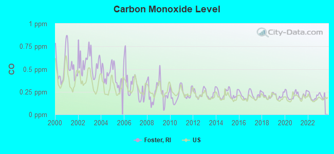
Carbon Monoxide (CO) [ppm] level in 2022 was 0.196. This is better than average. Closest monitor was 16.2 miles away from the city center.
| City: | 0.196 |
| U.S.: | 0.251 |
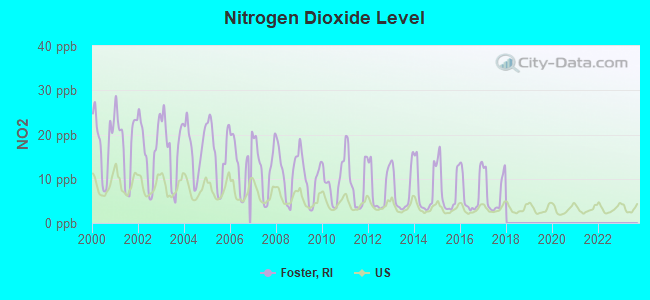
Nitrogen Dioxide (NO2) [ppb] level in 2017 was 6.83. This is worse than average. Closest monitor was 12.3 miles away from the city center.
| City: | 6.83 |
| U.S.: | 5.11 |
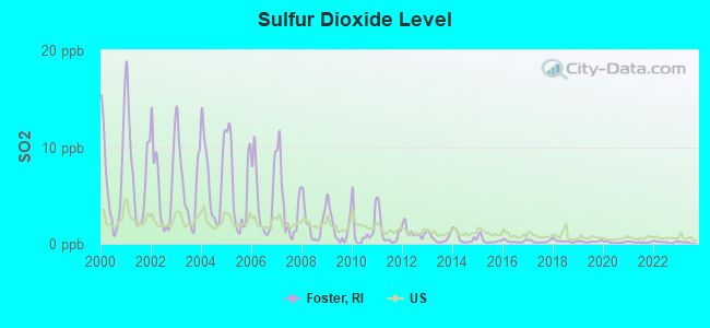
Sulfur Dioxide (SO2) [ppb] level in 2022 was 0.179. This is significantly better than average. Closest monitor was 12.3 miles away from the city center.
| City: | 0.179 |
| U.S.: | 1.515 |
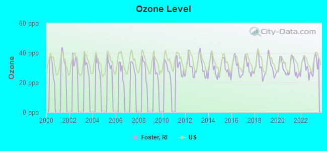
Ozone [ppb] level in 2023 was 33.4. This is about average. Closest monitor was 8.7 miles away from the city center.
| City: | 33.4 |
| U.S.: | 33.3 |
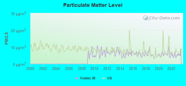
Particulate Matter (PM2.5) [µg/m3] level in 2022 was 5.09. This is significantly better than average. Closest monitor was 8.5 miles away from the city center.
| City: | 5.09 |
| U.S.: | 8.11 |
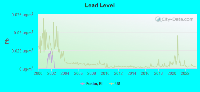
Lead (Pb) [µg/m3] level in 2001 was 0.0163. This is significantly worse than average. Closest monitor was 12.6 miles away from the city center.
| City: | 0.0163 |
| U.S.: | 0.0093 |
Tornado activity:
Foster-area historical tornado activity is slightly above Rhode Island state average. It is 39% smaller than the overall U.S. average.
On 6/9/1953, a category F4 (max. wind speeds 207-260 mph) tornado 36.4 miles away from the Foster town center killed 90 people and injured 1228 people and caused between $50,000,000 and $500,000,000 in damages.
On 6/9/1953, a category F3 (max. wind speeds 158-206 mph) tornado 25.9 miles away from the town center injured 17 people and caused between $500,000 and $5,000,000 in damages.
Earthquake activity:
Foster-area historical earthquake activity is significantly above Rhode Island state average. It is 73% smaller than the overall U.S. average.On 10/7/1983 at 10:18:46, a magnitude 5.3 (5.1 MB, 5.3 LG, 5.1 ML, Class: Moderate, Intensity: VI - VII) earthquake occurred 199.5 miles away from the city center
On 4/20/2002 at 10:50:47, a magnitude 5.3 (5.3 ML, Depth: 3.0 mi) earthquake occurred 212.5 miles away from Foster center
On 4/20/2002 at 10:50:47, a magnitude 5.2 (5.2 MB, 4.2 MS, 5.2 MW, 5.0 MW) earthquake occurred 211.4 miles away from the city center
On 1/19/1982 at 00:14:42, a magnitude 4.7 (4.5 MB, 4.7 MD, 4.5 LG, Class: Light, Intensity: IV - V) earthquake occurred 118.0 miles away from the city center
On 10/16/2012 at 23:12:25, a magnitude 4.7 (4.7 ML, Depth: 10.0 mi) earthquake occurred 135.9 miles away from Foster center
On 8/22/1992 at 12:20:32, a magnitude 4.8 (4.8 MB, 3.8 MS, 4.7 LG, Depth: 6.2 mi) earthquake occurred 200.3 miles away from the city center
Magnitude types: regional Lg-wave magnitude (LG), body-wave magnitude (MB), duration magnitude (MD), local magnitude (ML), surface-wave magnitude (MS), moment magnitude (MW)
Natural disasters:
The number of natural disasters in Providence County (17) is near the US average (15).Major Disasters (Presidential) Declared: 7
Emergencies Declared: 10
Causes of natural disasters: Hurricanes: 5, Snowstorms: 4, Blizzards: 3, Floods: 2, Storms: 2, Winter Storms: 2, Snow: 1, Snowfall: 1, Tropical Storm: 1, Water Main Break: 1, Wind: 1, Other: 1 (Note: some incidents may be assigned to more than one category).
Hospitals and medical centers in Foster:
Other hospitals and medical centers near Foster:
- HARRIS MANOR (QGHS LLC) (Nursing Home, about 4 miles away; NORTH SCITUATE, RI)
- WOODPECKER HILL HEALTH CENTER (Nursing Home, about 8 miles away; GREENE, RI)
- REGENCY HEIGHTS OF DANIELSON, LLC (Nursing Home, about 8 miles away; DANIELSON, CT)
- WESTVIEW NURSING CARE AND REHAB (Nursing Home, about 10 miles away; DAYVILLE, CT)
- ALPINE NURSING HOME INC (Nursing Home, about 10 miles away; COVENTRY, RI)
- GREENVILLE SKILLED NURSING AND REHABILITATION (Nursing Home, about 10 miles away; GREENVILLE, RI)
- PINE GROVE HEALTH CENTER (Nursing Home, about 10 miles away; PASCOAG, RI)
Amtrak station near Foster:
Colleges/universities with over 2000 students nearest to Foster:
- Bryant University (about 13 miles; Smithfield, RI; Full-time enrollment: 3,440)
- Rhode Island College (about 14 miles; Providence, RI; FT enrollment: 7,189)
- Community College of Rhode Island (about 14 miles; Warwick, RI; FT enrollment: 10,500)
- New England Institute of Technology (about 15 miles; East Greenwich, RI; FT enrollment: 3,183)
- Providence College (about 16 miles; Providence, RI; FT enrollment: 4,312)
- Johnson & Wales University-Providence (about 17 miles; Providence, RI; FT enrollment: 10,898)
- Rhode Island School of Design (about 17 miles; Providence, RI; FT enrollment: 2,714)
Public elementary/middle school in Foster:
- CAPT. ISAAC PAINE EL. SCHOOL (Students: 272, Location: 160 FOSTER CENTER ROAD, Grades: KG-5)
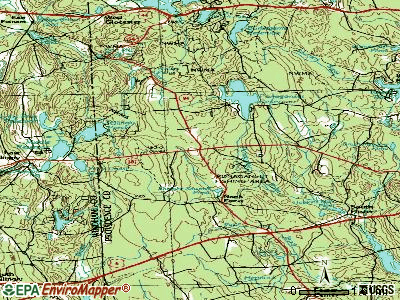
Points of interest:
Notable locations in Foster: Mount Vernon (A), Fisher Country Club (B), Mount Vernon Camp (C), Ponagansett Public Fishing Area (D), Foster Town Hall (E), Foster Ambulance Corps (F), South Foster Fire Department (G), Moosup Valley Fire Department (H), Foster Public Library (I), Foster Police Department (J), Foster Center Fire Department (K), Tyler Free Library (L). Display/hide their locations on the map
Churches in Foster include: North Foster Baptist Church (A), Clayville Church (B), Mount Vernon Church (C). Display/hide their locations on the map
Cemeteries: Hopkins Cemetery (1), Hopkins Mills Cemetery (2), Old Howard Plot (3), Phillips Cemetery (4), Sandy Brook Cemetery (5), Stone Plot (6). Display/hide their locations on the map
Lakes, reservoirs, and swamps: Porters Pond (A), Shippee Sawmill Pond (B), Spear Pond (C), Hopkins Mills Pond (D), Barden Reservoir (E), Clark Pond (F), Keech Pond (G), Westconnaug Reservoir (H). Display/hide their locations on the map
Streams, rivers, and creeks: Killy Brook (A), Shippee Brook (B), Dolly Cole Brook (C), Paine Brook (D), Hemlock Brook (E), Huntington Brook (F), Winsor Brook (G), Turkey Meadow Brook (H), West Meadow Brook (I). Display/hide their locations on the map
Parks in Foster include: Hopkins Mill Historic District (1), Clayville Historic District (2), Foster Center Historic District (3), Mooseup Valley Historic District (4). Display/hide their locations on the map
Hotel: Stone House Motor Inn (162 Danielson Pike) (1). Display/hide its approximate location on the map
Birthplace of: Whipple Van Buren Phillips - Businessman, Nelson W. Aldrich.
Drinking water stations with addresses in Foster and their reported violations in the past:
GINNY-B FAMILY CAMPGROUND (Population served: 600, Groundwater):Past health violations:SHADY ACRES RESTAURANT LLC (Population served: 260, Groundwater):Past monitoring violations:
- MCL, Monthly (TCR) - Between APR-2013 and JUN-2013, Contaminant: Coliform. Follow-up actions: St Violation/Reminder Notice (JUN-10-2013), St Public Notif requested (JUN-10-2013), St Formal NOV issued (JUN-10-2013), St Public Notif received (JUN-13-2013), St Compliance achieved (JUL-01-2013)
- Monitoring, Source Water (GWR) - In JUN-01-2013, Contaminant: E. COLI. Follow-up actions: St Formal NOV issued (JUN-18-2013), St Public Notif requested (JUN-18-2013), St Violation/Reminder Notice (JUN-18-2013), St Public Notif received (JUL-29-2013), St Compliance achieved (AUG-08-2013)
- One minor monitoring violation
Past health violations:FOSTER COUNTRY CLUB INC. (FRIEL GOLF CO) (Population served: 200, Groundwater):
- MCL, Monthly (TCR) - In MAY-2005, Contaminant: Coliform. Follow-up actions: St Public Notif requested (MAY-13-2005), St Boil Water Order (MAY-13-2005), St Formal NOV issued (MAY-13-2005), St Tech Assistance Visit (MAY-13-2005), St Violation/Reminder Notice (MAY-13-2005), St Public Notif received (JUN-06-2005), St Compliance achieved (JUN-06-2005)
- MCL, Monthly (TCR) - Between APR-2005 and JUN-2005, Contaminant: Coliform. Follow-up actions: St Public Notif requested (MAY-02-2005), St Boil Water Order (MAY-02-2005), St Formal NOV issued (MAY-02-2005), St Violation/Reminder Notice (MAY-02-2005), St Tech Assistance Visit (MAY-04-2005), St Public Notif received (MAY-10-2005), St Compliance achieved (MAY-10-2005)
Past health violations:CORNER BISTRO, LLC (Population served: 105, Groundwater):Past monitoring violations:
- MCL, Monthly (TCR) - In NOV-2010, Contaminant: Coliform. Follow-up actions: St Violation/Reminder Notice (DEC-07-2010), St Boil Water Order (DEC-07-2010), St Formal NOV issued (DEC-07-2010), St Public Notif requested (DEC-07-2010), St Public Notif received (DEC-08-2010), St Compliance achieved (JAN-05-2011)
- MCL, Monthly (TCR) - Between APR-2008 and JUN-2008, Contaminant: Coliform. Follow-up actions: St Violation/Reminder Notice (JUN-16-2008), St Boil Water Order (JUN-16-2008), St Formal NOV issued (JUN-16-2008), St Public Notif requested (JUN-16-2008), St Compliance achieved (JUL-07-2008), St Public Notif received (JUL-07-2008)
- Monitoring, Repeat Major (TCR) - In DEC-2010, Contaminant: Coliform (TCR). Follow-up actions: St Public Notif requested (DEC-14-2010), St Formal NOV issued (DEC-14-2010), St Violation/Reminder Notice (DEC-14-2010), St Compliance achieved (DEC-18-2010), St Public Notif received (DEC-18-2010)
- Monitoring, Repeat Major (TCR) - In SEP-2005, Contaminant: Coliform (TCR). Follow-up actions: St Public Notif requested (NOV-15-2005), St Formal NOV issued (NOV-15-2005), St Violation/Reminder Notice (NOV-15-2005), St Compliance achieved (JUN-13-2006), St Public Notif received (JUN-13-2006)
- 3 routine major monitoring violations
Past health violations:FOSTER TOWN HALL (Population served: 90, Groundwater):Past monitoring violations:
- MCL, Monthly (TCR) - In OCT-2007, Contaminant: Coliform. Follow-up actions: St Violation/Reminder Notice (OCT-11-2007), St Boil Water Order (OCT-11-2007), St Formal NOV issued (OCT-11-2007), St Public Notif requested (OCT-11-2007), St Public Notif received (OCT-18-2007), St Compliance achieved (NOV-19-2007)
- MCL, Monthly (TCR) - In SEP-2007, Contaminant: Coliform. Follow-up actions: St Violation/Reminder Notice (SEP-17-2007), St Boil Water Order (SEP-17-2007), St Formal NOV issued (SEP-17-2007), St Public Notif requested (SEP-17-2007), St Public Notif received (OCT-18-2007), St Compliance achieved (NOV-19-2007)
- MCL, Monthly (TCR) - In AUG-2007, Contaminant: Coliform. Follow-up actions: St Violation/Reminder Notice (AUG-14-2007), St Boil Water Order (AUG-14-2007), St Formal NOV issued (AUG-14-2007), St Public Notif requested (AUG-14-2007), St Public Notif received (OCT-18-2007), St Compliance achieved (NOV-19-2007)
- 3 routine major monitoring violations
Past monitoring violations:LUCKYS (Population served: 52, Groundwater):
- Initial Tap Sampling for Pb and Cu - In JUL-01-2009, Contaminant: Lead and Copper Rule. Follow-up actions: St Formal NOV issued (OCT-29-2009), St Violation/Reminder Notice (OCT-29-2009), St Public Notif requested (OCT-29-2009), St BCA signed (NOV-20-2009), St Public Notif received (JAN-08-2010), St Compliance achieved (JUN-08-2010)
- Initial Tap Sampling for Pb and Cu - In JUL-01-2008, Contaminant: Lead and Copper Rule. Follow-up actions: St Formal NOV issued (MAR-16-2009), St Violation/Reminder Notice (MAR-16-2009), St Public Notif requested (MAR-16-2009), St Public Notif received (JAN-08-2010), St Compliance achieved (JAN-08-2010)
Past health violations:DANNYS AUCTION (Population served: 50, Groundwater):Past monitoring violations:
- MCL, Monthly (TCR) - Between OCT-2007 and DEC-2007, Contaminant: Coliform. Follow-up actions: St Violation/Reminder Notice (NOV-21-2007), St Boil Water Order (NOV-21-2007), St Formal NOV issued (NOV-21-2007), St Public Notif requested (NOV-21-2007), St Public Notif received (NOV-28-2007), St Compliance achieved (NOV-30-2007)
- 2 routine major monitoring violations
Past monitoring violations:ABBEY LANE COMMUNITY ASSN., INC. (Population served: 45, Groundwater):
- One routine major monitoring violation
Past health violations:Past monitoring violations:
- MCL, Monthly (TCR) - Between JUL-2009 and SEP-2009, Contaminant: Coliform. Follow-up actions: St Formal NOV issued (AUG-11-2009), St Violation/Reminder Notice (AUG-11-2009), St Public Notif requested (AUG-11-2009), St Public Notif received (AUG-18-2009), St Compliance achieved (AUG-19-2009)
- One routine major monitoring violation
Drinking water stations with addresses in Foster that have no violations reported:
- ST. PAUL THE APOSTLE CHURCH (Population served: 200, Primary Water Source Type: Groundwater)
- LINE BAPTIST CHURCH (Population served: 35, Primary Water Source Type: Groundwater)
| This town: | 2.7 people |
| Rhode Island: | 2.4 people |
| This town: | 76.3% |
| Whole state: | 62.8% |
| This town: | 6.6% |
| Whole state: | 7.6% |
Likely homosexual households (counted as self-reported same-sex unmarried-partner households)
- Lesbian couples: 0.8% of all households
- Gay men: 0.3% of all households
| This town: | 3.4% |
| Whole state: | 11.9% |
| This town: | 0.4% |
| Whole state: | 5.4% |
4 people in group homes intended for adults in 2010
20 people in nursing homes in 2000
4 people in homes for the mentally retarded in 2000
For population 15 years and over in Foster:
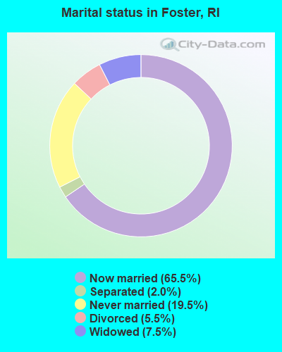
- Never married: 19.5%
- Now married: 65.5%
- Separated: 2.0%
- Widowed: 7.5%
- Divorced: 5.5%
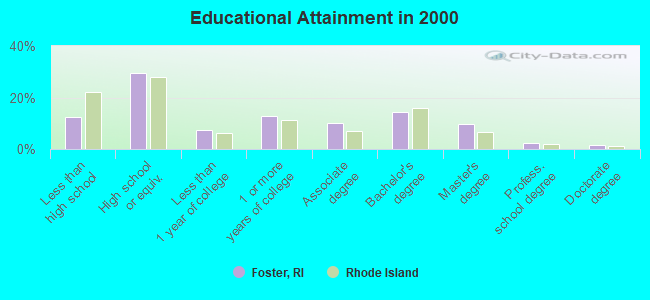
For population 25 years and over in Foster:
- High school or higher: 87.7%
- Bachelor's degree or higher: 27.7%
- Graduate or professional degree: 13.3%
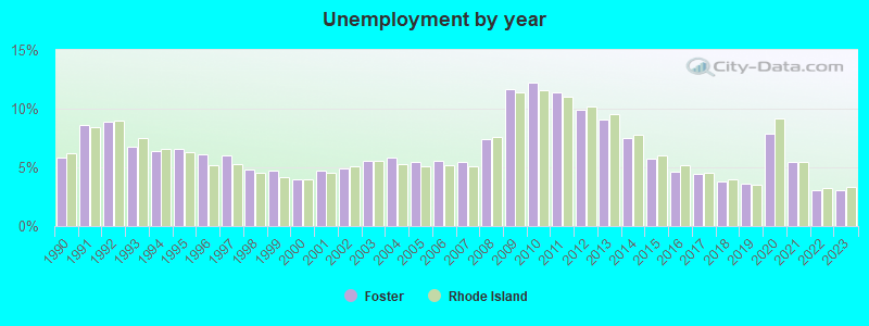
- Unemployed: 5.4%
- Mean travel time to work (commute): 32.9 minutes
| Here: | 11.0 |
| Rhode Island average: | 14.0 |
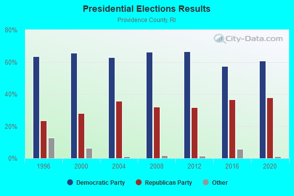
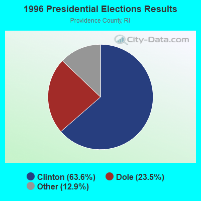
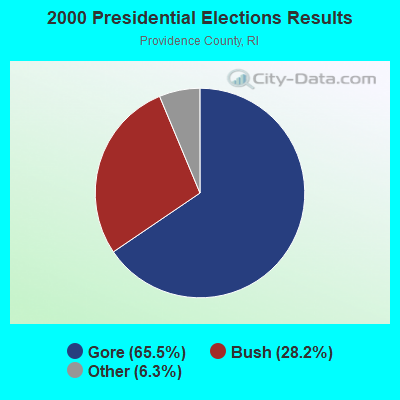
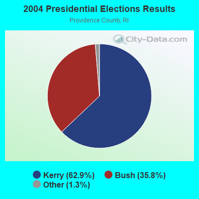
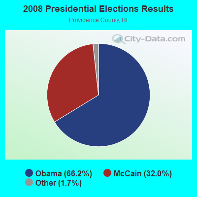
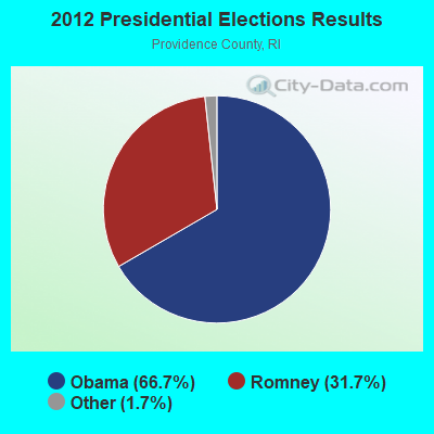
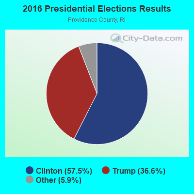
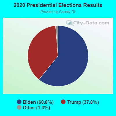
Graphs represent county-level data. Detailed 2008 Election Results
Religion statistics for Foster, RI (based on Providence County data)
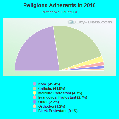
| Religion | Adherents | Congregations |
|---|---|---|
| Catholic | 276,011 | 98 |
| Mainline Protestant | 27,143 | 111 |
| Evangelical Protestant | 16,895 | 134 |
| Other | 13,896 | 48 |
| Orthodox | 7,325 | 10 |
| Black Protestant | 712 | 9 |
| None | 284,685 | - |
Food Environment Statistics:
| Providence County: | 2.06 / 10,000 pop. |
| Rhode Island: | 1.92 / 10,000 pop. |
| This county: | 0.02 / 10,000 pop. |
| State: | 0.05 / 10,000 pop. |
| Providence County: | 1.50 / 10,000 pop. |
| Rhode Island: | 1.42 / 10,000 pop. |
| Providence County: | 2.10 / 10,000 pop. |
| State: | 2.24 / 10,000 pop. |
| Here: | 7.96 / 10,000 pop. |
| State: | 9.75 / 10,000 pop. |
| This county: | 8.1% |
| Rhode Island: | 7.9% |
| Providence County: | 24.0% |
| Rhode Island: | 22.6% |
| This county: | 16.9% |
| State: | 16.3% |
5.01% of this county's 2021 resident taxpayers lived in other counties in 2020 ($66,379 average adjusted gross income)
| Here: | 5.01% |
| Rhode Island average: | 5.99% |
0.03% of residents moved from foreign countries ($121 average AGI)
Providence County: 0.03% Rhode Island average: 0.03%
Top counties from which taxpayers relocated into this county between 2020 and 2021:
| from Kent County, RI | |
| from Bristol County, MA | |
| from Suffolk County, MA |
5.35% of this county's 2020 resident taxpayers moved to other counties in 2021 ($68,172 average adjusted gross income)
| Here: | 5.35% |
| Rhode Island average: | 5.97% |
0.01% of residents moved to foreign countries ($59 average AGI)
Providence County: 0.01% Rhode Island average: 0.02%
Top counties to which taxpayers relocated from this county between 2020 and 2021:
| to Kent County, RI | |
| to Bristol County, MA | |
| to Washington County, RI |
Strongest AM radio stations in Foster:
- WALE (990 AM; 50 kW; GREENVILLE, RI; Owner: NORTH AMERICAN BROADCASTING CO., INC.)
- WCRN (830 AM; 50 kW; WORCESTER, MA; Owner: CARTER BROADCASTING CORPORATION)
- WEEI (850 AM; 50 kW; BOSTON, MA; Owner: ENTERCOM BOSTON LICENSE, LLC)
- WRNI (1290 AM; 10 kW; PROVIDENCE, RI; Owner: WRNI FOUNDATION)
- WKOX (1200 AM; 50 kW; FRAMINGHAM, MA; Owner: CAPSTAR TX LIMITED PARTNERSHIP)
- WINY (1350 AM; 5 kW; PUTNAM, CT; Owner: OSBREY BROADCASTING COMPANY)
- WBIX (1060 AM; 40 kW; NATICK, MA; Owner: LANGER BROADCASTING CORPORATION)
- WVNE (760 AM; daytime; 25 kW; LEICESTER, MA; Owner: BLOUNT MASSCOM, INC.)
- WRKO (680 AM; 50 kW; BOSTON, MA; Owner: ENTERCOM BOSTON LICENSE, LLC)
- WAMG (890 AM; 25 kW; DEDHAM, MA; Owner: MEGA COMMUNICATIONS OF DEDHAM LICENSEE, LLC)
- WDDZ (550 AM; 5 kW; PAWTUCKET, RI; Owner: ABC, INC.)
- WNNZ (640 AM; 50 kW; WESTFIELD, MA; Owner: CLEAR CHANNEL BROADCASTING LICENSES, INC.)
- WSKO (790 AM; 5 kW; PROVIDENCE, RI; Owner: CITADEL BROADCASTING COMPANY)
Strongest FM radio stations in Foster:
- WWRX-FM (103.7 FM; WESTERLY, RI; Owner: FNX BROADCASTING OF RHODE ISLAND, LLC)
- WPRO-FM (92.3 FM; PROVIDENCE, RI; Owner: CITADEL BROADCASTING COMPANY)
- WWLI (105.1 FM; PROVIDENCE, RI; Owner: CITADEL BROADCASTING COMPANY)
- WWBB (101.5 FM; PROVIDENCE, RI; Owner: CLEAR CHANNEL BROADCASTING LICENSES, INC.)
- WWKX (106.3 FM; WOONSOCKET, RI; Owner: AAA ENTERTAINMENT LICENSING LLC)
- WSKO-FM (99.7 FM; WAKEFIELD-PEACEDALE, RI; Owner: CITADEL BROADCASTING COMPANY)
- WBRU (95.5 FM; PROVIDENCE, RI; Owner: BROWN BROADCASTING SERVICE, INC.)
- WSNE-FM (93.3 FM; TAUNTON, MA; Owner: CAPSTAR TX LIMITED PARTNERSHIP)
- WHJY (94.1 FM; PROVIDENCE, RI; Owner: CAPSTAR TX LIMITED PARTNERSHIP)
- WAAF (107.3 FM; WORCESTER, MA; Owner: ENTERCOM BOSTON LICENSE, LLC)
- WBVC (91.1 FM; POMFRET, CT; Owner: POMFRET SCHOOL)
- WWFX (100.1 FM; SOUTHBRIDGE, MA; Owner: CITADEL BROADCASTING COMPANY)
- WKKB (100.3 FM; MIDDLETOWN, RI; Owner: CITADEL BROADCASTING COMPANY)
- WBMX (98.5 FM; BOSTON, MA; Owner: INFINITY RADIO OPERATIONS INC.)
- WJMN (94.5 FM; BOSTON, MA; Owner: AMFM RADIO LICENSES, L.L.C.)
- WBOS (92.9 FM; BROOKLINE, MA; Owner: GREATER BOSTON RADIO, INC.)
- WCRB (102.5 FM; WALTHAM, MA; Owner: CHARLES RIVER BROADCASTING WCRB LICE)
- WTKK (96.9 FM; BOSTON, MA; Owner: GREATER BOSTON RADIO, INC.)
- WROR-FM (105.7 FM; FRAMINGHAM, MA; Owner: GREATER BOSTON RADIO, INC.)
- WSRS (96.1 FM; WORCESTER, MA; Owner: CAPSTAR TX LIMITED PARTNERSHIP)
TV broadcast stations around Foster:
- WPXQ (Channel 69; BLOCK ISLAND, RI; Owner: OCEAN STATE TELEVISION, L.L.C.)
- WRIW-LP (Channel 50; PROVIDENCE, RI; Owner: ZGS PROVIDENCE, INC.)
- WNAC-TV (Channel 64; PROVIDENCE, RI; Owner: WNAC, LLC)
- WPRI-TV (Channel 12; PROVIDENCE, RI; Owner: TVL BROADCASTING OF RHODE ISLAND, LLC)
- WJAR (Channel 10; PROVIDENCE, RI; Owner: OUTLET BROADCASTING, INC.)
- WLNE-TV (Channel 6; NEW BEDFORD, MA; Owner: FREEDOM BROADCASTING OF SOUTHERN NEW ENGLAND, INC.)
- WSBE-TV (Channel 36; PROVIDENCE, RI; Owner: RHODE ISLAND PUBLIC TELECOM. AUTHORITY)
- WCVB-TV (Channel 5; BOSTON, MA; Owner: WCVB HEARST-ARGYLE TV, INC.)
- WUNI (Channel 27; WORCESTER, MA; Owner: ENTRAVISION HOLDINGS, LLC)
- WYDN (Channel 48; WORCESTER, MA; Owner: EDUCATIONAL PUBLIC TV CORPORATION)
- WGBH-TV (Channel 2; BOSTON, MA; Owner: WGBH EDUCATIONAL FOUNDATION)
- WHPX (Channel 26; NEW LONDON, CT; Owner: PAXSON HARTFORD LICENSE, INC.)
- WHDH-TV (Channel 7; BOSTON, MA; Owner: WHDH-TV)
- WMFP (Channel 62; LAWRENCE, MA; Owner: WSAH LICENSE, INC.)
- WSBK-TV (Channel 38; BOSTON, MA; Owner: VIACOM INC.)
- WUTF (Channel 66; MARLBOROUGH, MA; Owner: TELEFUTURA BOSTON LLC)
- WLVI-TV (Channel 56; CAMBRIDGE, MA; Owner: WLVI, INC.)
- WBZ-TV (Channel 4; BOSTON, MA; Owner: VIACOM INC.)
- WGBX-TV (Channel 44; BOSTON, MA; Owner: WGBH EDUCATIONAL FOUNDATION)
- WWDP (Channel 46; NORWELL, MA; Owner: NORWELL TELEVISION, LLC)
- WTIC-TV (Channel 61; HARTFORD, CT; Owner: TRIBUNE TELEVISION COMPANY)
- WFXT (Channel 25; BOSTON, MA; Owner: FOX TELEVISION STATIONS INC.)
- WEDN (Channel 53; NORWICH, CT; Owner: CONNECTICUT PUBLIC BROADCASTING, INC.)
- National Bridge Inventory (NBI) Statistics
- 14Number of bridges
- 49ft / 14.7mTotal length
- $5,184,000Total costs
- 43,145Total average daily traffic
- 3,154Total average daily truck traffic
- 47,480Total future (year 2036) average daily traffic
- New bridges - historical statistics
- 11920-1929
- 31930-1939
- 71950-1959
- 11960-1969
- 11990-1999
- 12010-2019
FCC Registered Cell Phone Towers:
1 (See the full list of FCC Registered Cell Phone Towers in Foster)FCC Registered Antenna Towers:
21 (See the full list of FCC Registered Antenna Towers)FCC Registered Private Land Mobile Towers:
2- Rt 101 Jerimoth Hill (Lat: 41.851778 Lon: -71.778694), Structure height: 68 m, Call Sign: WNRL656, Licensee ID: L00342962,
Assigned Frequencies: 854.562 MHz, Grant Date: 03/08/2000, Expiration Date: 03/08/2010, Cancellation Date: 04/03/2001, Registrant: Telecom Leasing Corp, 5 Gough Ave, West Warwick, RI 02893, Phone: (401) 822-3463
- Lat: 41.842750 Lon: -71.714250, Call Sign: WPZF356,
Assigned Frequencies: 470.325 MHz, 472.887 MHz, 473.325 MHz, 475.887 MHz, Grant Date: 02/27/2024, Expiration Date: 01/06/2034, Certifier: Joseph A Accetta, Registrant: Radio-Phone Communications Inc, 153 James P Murphy Ind Hwy Suite 1, Warwick, RI 02893-2382, Phone: (401) 823-3600, Email:
FCC Registered Broadcast Land Mobile Towers:
3- Police Dept Howard Hill Rd (Lat: 41.750111 Lon: -71.709222), Call Sign: KWO599, Licensee ID: L00084306,
Assigned Frequencies: 155.535 MHz, Grant Date: 07/23/2004, Expiration Date: 09/29/2014, Cancellation Date: 10/27/2010, Registrant: Foster, Town Of, Howard Hill Rd, Foster, RI 02825, Phone: (401) 397-3317
- Jerimoth Hill (Lat: 41.852056 Lon: -71.778417), Type: Tower, Structure height: 57 m, Overall height: 60 m, Call Sign: WPRT305,
Assigned Frequencies: 937.187 MHz, 937.637 MHz, 937.675 MHz, 938.137 MHz, 939.675 MHz, Grant Date: 01/19/2001, Expiration Date: 01/19/2006, Cancellation Date: 03/25/2006, Certifier: Alfred Dirico, Registrant: Industrial Communications & Electro, 40 Lone Street, Marshfield, MA 02050, Phone: (781) 319-1011, Fax: (781) 837-4000
- Lat: 41.784833 Lon: -71.719222, Call Sign: WQCH884,
Assigned Frequencies: 75.5600 MHz, Grant Date: 03/10/2015, Expiration Date: 03/08/2025, Certifier: Gordon Brayton, Registrant: Town Of Foster, 103 Central Pike, Foster, RI 02825, Phone: (401) 647-3780, Fax: (401) 647-3780, Email:
FCC Registered Amateur Radio Licenses:
47 (See the full list of FCC Registered Amateur Radio Licenses in Foster)FAA Registered Aircraft:
3- Aircraft: PIPER PA-28-180 (Category: Land, Seats: 4, Weight: Up to 12,499 Pounds, Speed: 107 mph), Engine: LYCOMING O&VO-360 SER (180 HP) (Reciprocating)
N-Number: 15483, N15483, N-15483, Serial Number: 28-7305082, Year manufactured: 1972, Airworthiness Date: 11/03/1972, Certificate Issue Date: 08/27/2013
Registrant (Individual): William S Boyce, 5 E Killingly Rd, Foster, RI 02825 - Aircraft: WOOD ROBERT L. THORP T-18 (Category: Land, Seats: 2, Weight: Up to 12,499 Pounds), Engine: LYCOMING I0360 SER (180 HP) (Reciprocating)
N-Number: 335BW, N335BW, N-335BW, Serial Number: 720, Year manufactured: 1995, Airworthiness Date: 07/06/1995, Certificate Issue Date: 03/16/2011
Registrant (LLC): Thorp T-18 Ri LLC, 50 Plainfield Pike, Foster, RI 02825 - Aircraft: CESSNA A150L (Category: Land, Seats: 2, Weight: Up to 12,499 Pounds, Speed: 90 mph), Engine: CONT MOTOR 0-200 SERIES (100 HP) (Reciprocating)
N-Number: 8123L, N8123L, N-8123L, Serial Number: A1500499, Year manufactured: 1974, Airworthiness Date: 03/28/1974, Certificate Issue Date: 06/13/1985
Registrant (Individual): Norman J Shippee, 178 Hartford Pike, Foster, RI 02825
2006 - 2018 National Fire Incident Reporting System (NFIRS) incidents
- Fire incident types reported to NFIRS in Foster, RI
- 24961.3%Structure Fires
- 11327.8%Outside Fires
- 266.4%Other
- 184.4%Mobile Property/Vehicle Fires
 According to the data from the years 2006 - 2018 the average number of fires per year is 31. The highest number of fire incidents - 57 took place in 2016, and the least - 4 in 2006. The data has a rising trend.
 When looking into fire subcategories, the most reports belonged to: Structure Fires (61.3%), and Outside Fires (27.8%).
- 81.3%Fuel oil, kerosene, etc.
- 11.7%Wood
- 4.2%Bottled, tank, or LP gas
- 2.1%Electricity
- 0.4%Utility gas
- 0.4%Other fuel
- 51.4%Fuel oil, kerosene, etc.
- 24.3%Bottled, tank, or LP gas
- 15.1%Wood
- 5.9%Utility gas
- 3.2%Electricity
Foster compared to Rhode Island state average:
- Unemployed percentage below state average.
- Black race population percentage significantly below state average.
- Hispanic race population percentage significantly below state average.
- Foreign-born population percentage significantly below state average.
- Renting percentage significantly below state average.
- Length of stay since moving in significantly above state average.
- Number of rooms per house significantly below state average.
- House age significantly below state average.

|
|
Total of 116 patent applications in 2008-2024.