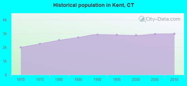
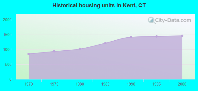
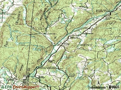
Kent, Connecticut
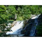
Kent: Kent Falls State Park
Kent: Kent Falls State Park
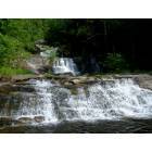
Kent: Kent Falls State Park
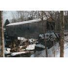
Kent: Bulls Bridge
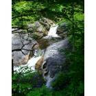
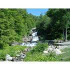
Kent: Kent Falls

Kent: Warren Farm on Treasure Hill Road
- add
your


Submit your own pictures of this town and show them to the world
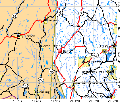
- OSM Map
- General Map
- Google Map
- MSN Map
Population change since 2000: +4.2%
 |
| Males: 1,469 | |
| Females: 1,510 |
| Median resident age: | 48.9 years |
| Connecticut median age: | 39.2 years |
Zip codes: 06757.
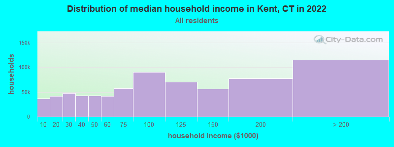
| Kent: | $88,381 |
| CT: | $88,429 |
Estimated per capita income in 2022: $69,347 (it was $38,674 in 2000)
Kent town income, earnings, and wages data
Estimated median house or condo value in 2022: $419,191 (it was $193,900 in 2000)
| Kent: | $419,191 |
| CT: | $347,200 |
Mean prices in 2022: all housing units: $429,743; detached houses: $455,293; townhouses or other attached units: $232,674; in 2-unit structures: $242,050; in 3-to-4-unit structures: $229,634; in 5-or-more-unit structures: $182,162; mobile homes: $243,504; occupied boats, rvs, vans, etc.: $127,144
Detailed information about poverty and poor residents in Kent, CT


- 2,73991.9%White alone
- 943.2%Hispanic
- 491.6%Asian alone
- 381.3%Two or more races
- 341.1%Black alone
- 180.6%American Indian alone
- 60.2%Other race alone
- 10.03%Native Hawaiian and Other
Pacific Islander alone
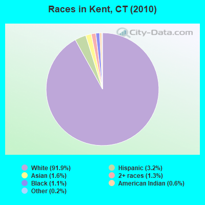
Races in Kent detailed stats: ancestries, foreign born residents, place of birth
According to our research of Connecticut and other state lists, there was 1 registered sex offender living in Kent, Connecticut as of May 08, 2024.
The ratio of all residents to sex offenders in Kent is 2,979 to 1.
The ratio of registered sex offenders to all residents in this city is much lower than the state average.
 Recent articles from our blog. Our writers, many of them Ph.D. graduates or candidates, create easy-to-read articles on a wide variety of topics.


 | 2024 Connecticut Town Tournament VI (Celebrating the 10-Year Anniversary & Dazzleman's Memorial) (830 replies) |
| Is Norwich Commutable to NYC? (100 replies) |
| Connecticut TOWN TOURNAMENT V (2022) (831 replies) |
| Ideas for Late Sept Visit (43 replies) |
| Connecticut Weekend (21 replies) |
| Connecticut TOWN TOURNAMENT IV (2020) (849 replies) |
Latest news from Kent, CT collected exclusively by city-data.com from local newspapers, TV, and radio stations
Kent, CT City Guides:
Ancestries: English (23.7%), Irish (20.7%), German (17.3%), Italian (8.8%), Scottish (5.7%), French (5.4%).
Current Local Time: EST time zone
Incorporated on 10/1739
Elevation: 397 feet
Land area: 48.5 square miles.
Population density: 61 people per square mile (very low).
231 residents are foreign born (5.9% Europe, 1.4% Asia).
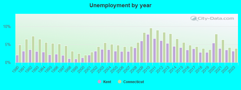
| This town: | 8.1% |
| Connecticut: | 10.9% |
| Kent town: | 1.3% ($2,467) |
| Connecticut: | 1.8% ($2,961) |
Nearest city with pop. 50,000+: Danbury, CT  (21.9 miles , pop. 74,848).
Nearest city with pop. 200,000+: Bronx, NY (64.2 miles , pop. 1,332,650).
Nearest cities:
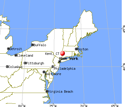
), Latitude: 41.72 N, Longitude: 73.45 W
Area code: 860

Kent tourist attractions:
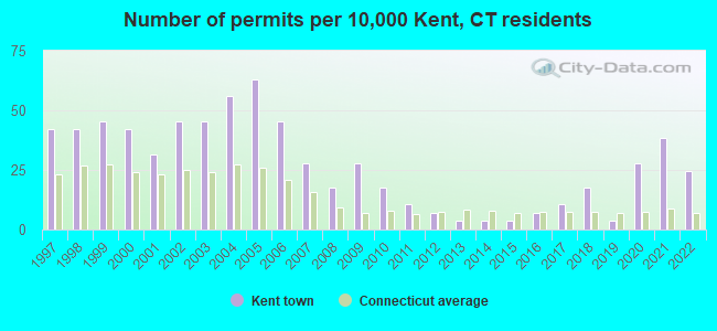
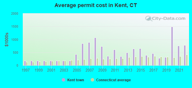
Single-family new house construction building permits:
- 2022: 7 buildings, average cost: $775,000
- 2021: 11 buildings, average cost: $755,000
- 2020: 8 buildings, average cost: $1,487,700
- 2019: 1 building, cost: $315,000
- 2018: 5 buildings, average cost: $280,000
- 2017: 3 buildings, average cost: $459,500
- 2016: 2 buildings, average cost: $400,000
- 2015: 1 building, cost: $650,000
- 2014: 1 building, cost: $643,000
- 2013: 1 building, cost: $500,000
- 2012: 2 buildings, average cost: $348,500
- 2011: 3 buildings, average cost: $610,000
- 2010: 5 buildings, average cost: $360,200
- 2009: 8 buildings, average cost: $729,600
- 2008: 5 buildings, average cost: $1,075,600
- 2007: 8 buildings, average cost: $892,300
- 2006: 13 buildings, average cost: $843,700
- 2005: 18 buildings, average cost: $427,600
- 2004: 16 buildings, average cost: $176,000
- 2003: 13 buildings, average cost: $176,000
- 2002: 13 buildings, average cost: $176,000
- 2001: 9 buildings, average cost: $176,000
- 2000: 12 buildings, average cost: $176,000
- 1999: 13 buildings, average cost: $176,000
- 1998: 12 buildings, average cost: $176,000
- 1997: 12 buildings, average cost: $176,200
| Here: | 3.2% |
| Connecticut: | 3.9% |
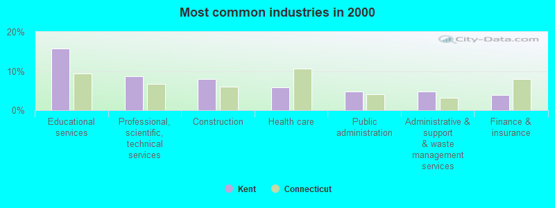
- Educational services (15.7%)
- Professional, scientific, technical services (8.6%)
- Construction (8.0%)
- Health care (5.9%)
- Public administration (4.8%)
- Administrative & support & waste management services (4.7%)
- Finance & insurance (3.9%)
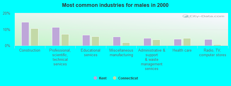
- Construction (14.6%)
- Professional, scientific, technical services (11.3%)
- Educational services (6.5%)
- Miscellaneous manufacturing (5.5%)
- Administrative & support & waste management services (4.6%)
- Health care (4.1%)
- Radio, TV, computer stores (4.0%)
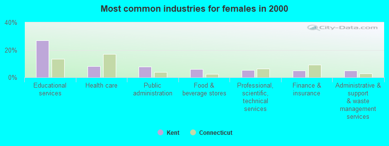
- Educational services (27.0%)
- Health care (8.1%)
- Public administration (7.7%)
- Food & beverage stores (6.0%)
- Professional, scientific, technical services (5.3%)
- Finance & insurance (5.0%)
- Administrative & support & waste management services (4.9%)
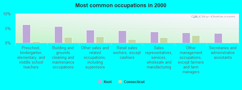
- Preschool, kindergarten, elementary, and middle school teachers (6.3%)
- Building and grounds cleaning and maintenance occupations (5.6%)
- Other sales and related occupations, including supervisors (4.4%)
- Retail sales workers, except cashiers (4.2%)
- Sales representatives, services, wholesale and manufacturing (3.8%)
- Other management occupations, except farmers and farm managers (3.5%)
- Secretaries and administrative assistants (3.3%)
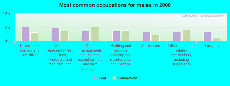
- Driver/sales workers and truck drivers (5.2%)
- Sales representatives, services, wholesale and manufacturing (4.7%)
- Other management occupations, except farmers and farm managers (3.6%)
- Building and grounds cleaning and maintenance occupations (3.6%)
- Carpenters (3.2%)
- Other sales and related occupations, including supervisors (3.2%)
- Lawyers (3.2%)
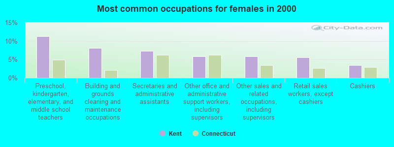
- Preschool, kindergarten, elementary, and middle school teachers (11.3%)
- Building and grounds cleaning and maintenance occupations (8.1%)
- Secretaries and administrative assistants (7.4%)
- Other office and administrative support workers, including supervisors (5.9%)
- Other sales and related occupations, including supervisors (5.9%)
- Retail sales workers, except cashiers (5.6%)
- Cashiers (3.4%)
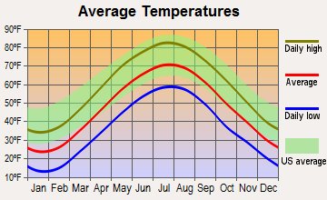
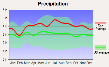
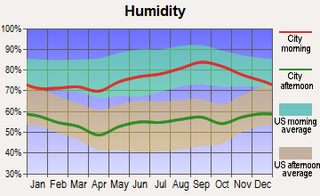
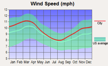
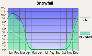
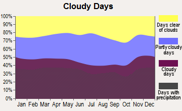
Average climate in Kent, Connecticut
Based on data reported by over 4,000 weather stations

(lower is better)
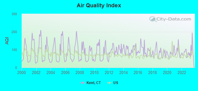
Air Quality Index (AQI) level in 2023 was 92.8. This is worse than average.
| City: | 92.8 |
| U.S.: | 72.6 |
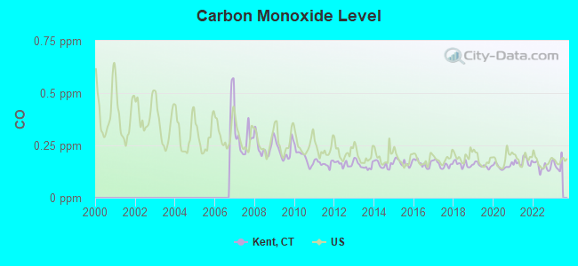
Carbon Monoxide (CO) [ppm] level in 2022 was 0.149. This is significantly better than average. Closest monitor was 10.7 miles away from the city center.
| City: | 0.149 |
| U.S.: | 0.251 |
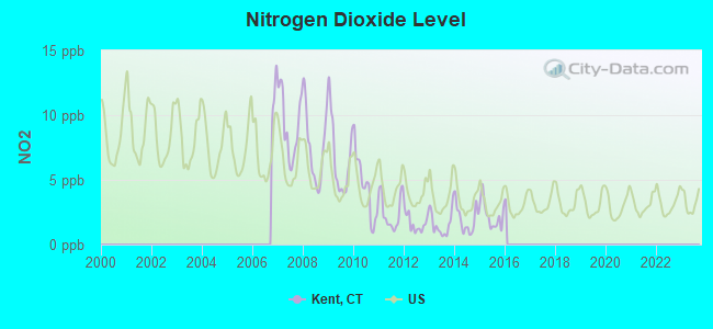
Nitrogen Dioxide (NO2) [ppb] level in 2015 was 2.27. This is significantly better than average. Closest monitor was 3.7 miles away from the city center.
| City: | 2.27 |
| U.S.: | 5.11 |
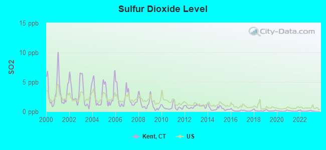
Sulfur Dioxide (SO2) [ppb] level in 2022 was 0.109. This is significantly better than average. Closest monitor was 3.7 miles away from the city center.
| City: | 0.109 |
| U.S.: | 1.515 |

Ozone [ppb] level in 2023 was 33.2. This is about average. Closest monitor was 10.7 miles away from the city center.
| City: | 33.2 |
| U.S.: | 33.3 |
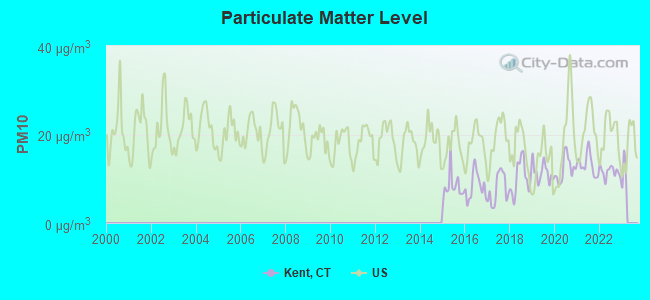
Particulate Matter (PM10) [µg/m3] level in 2022 was 11.6. This is significantly better than average. Closest monitor was 10.7 miles away from the city center.
| City: | 11.6 |
| U.S.: | 19.2 |
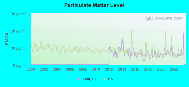
Particulate Matter (PM2.5) [µg/m3] level in 2022 was 5.67. This is significantly better than average. Closest monitor was 10.7 miles away from the city center.
| City: | 5.67 |
| U.S.: | 8.11 |
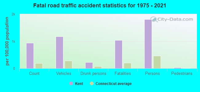
Tornado activity:
Kent-area historical tornado activity is near Connecticut state average. It is 23% smaller than the overall U.S. average.
On 5/29/1995, a category F4 (max. wind speeds 207-260 mph) tornado 33.3 miles away from the Kent town center killed 3 people and injured 24 people and caused between $5,000,000 and $50,000,000 in damages.
On 7/10/1989, a category F4 tornado 37.0 miles away from the town center injured 40 people and caused between $50,000,000 and $500,000,000 in damages.
Earthquake activity:
Kent-area historical earthquake activity is significantly above Connecticut state average. It is 69% smaller than the overall U.S. average.On 10/7/1983 at 10:18:46, a magnitude 5.3 (5.1 MB, 5.3 LG, 5.1 ML, Class: Moderate, Intensity: VI - VII) earthquake occurred 160.9 miles away from the city center
On 4/20/2002 at 10:50:47, a magnitude 5.3 (5.3 ML, Depth: 3.0 mi) earthquake occurred 193.6 miles away from Kent center
On 4/20/2002 at 10:50:47, a magnitude 5.2 (5.2 MB, 4.2 MS, 5.2 MW, 5.0 MW) earthquake occurred 191.9 miles away from the city center
On 8/23/2011 at 17:51:04, a magnitude 5.8 (5.8 MW, Depth: 3.7 mi) earthquake occurred 355.1 miles away from Kent center
On 1/19/1982 at 00:14:42, a magnitude 4.7 (4.5 MB, 4.7 MD, 4.5 LG, Class: Light, Intensity: IV - V) earthquake occurred 155.1 miles away from Kent center
On 1/16/1994 at 01:49:16, a magnitude 4.6 (4.6 MB, 4.6 LG, Depth: 3.1 mi) earthquake occurred 165.6 miles away from the city center
Magnitude types: regional Lg-wave magnitude (LG), body-wave magnitude (MB), duration magnitude (MD), local magnitude (ML), surface-wave magnitude (MS), moment magnitude (MW)
Natural disasters:
The number of natural disasters in Litchfield County (23) is greater than the US average (15).Major Disasters (Presidential) Declared: 13
Emergencies Declared: 10
Causes of natural disasters: Storms: 7, Hurricanes: 5, Floods: 4, Snowstorms: 4, Blizzards: 3, Snows: 2, Tropical Storms: 2, Winter Storms: 2, Snowfall: 1, Tornado: 1, Wind: 1 (Note: some incidents may be assigned to more than one category).
Hospitals and medical centers in Kent:
Other hospitals and medical centers near Kent:
- TACONIC DDSO (Hospital, about 7 miles away; WASSAIC, NY)
- NEW MILFORD VNA INC (Home Health Center, about 9 miles away; NEW MILFORD, CT)
- CANDLEWOOD VALLEY HEALTH AND R (Nursing Home, about 9 miles away; NEW MILFORD, CT)
- VILLAGE CREST CENTER FOR HEALTH AND REHABILITATION (Nursing Home, about 10 miles away; NEW MILFORD, CT)
- NEW MILFORD HOSPITAL Acute Care Hospitals (about 10 miles away; NEW MILFORD, CT)
- LIFESPIRE, INC (Hospital, about 11 miles away; WOODSIDE, NY)
- SHARON HEALTH CARE CENTER (Nursing Home, about 12 miles away; SHARON, CT)
Colleges/universities with over 2000 students nearest to Kent:
- Western Connecticut State University (about 23 miles; Danbury, CT; Full-time enrollment: 5,345)
- Vassar College (about 23 miles; Poughkeepsie, NY; FT enrollment: 2,469)
- Naugatuck Valley Community College (about 23 miles; Waterbury, CT; FT enrollment: 4,491)
- Post University (about 24 miles; Waterbury, CT; FT enrollment: 5,808)
- Dutchess Community College (about 24 miles; Poughkeepsie, NY; FT enrollment: 6,554)
- University of Connecticut-Tri-Campus (about 25 miles; Waterbury, CT; FT enrollment: 2,250)
- Culinary Institute of America (about 25 miles; Hyde Park, NY; FT enrollment: 3,869)
Private high schools in Kent:
Public elementary/middle schools in Kent:
- KENT CENTER SCHOOL (Students: 273, Location: 9 JUDD STREET, Grades: PK-8)
- LEAPSS (Location: 9 JUDD AVENUE, Grades: PK-4)
User-submitted facts and corrections:
- missing private high school SOUTH KENT SCHOOL
Points of interest:
Notable locations in Kent: Geer Mountain Camp (A), Camp Po-Ne-Mah (B), Camp Leonard Leonore (C), Camp Kent (D), Camp Kenmont (E), Camp Kenico (F), Camp Francis (G), Near East Camp (H), Skiff Mountain (I), Kent Town Hall (J), Kent Memorial Library (K), Kent Volunteer Fire Department (L), Kent Community House (M), Kent Art Association (N), Kent Building Fire Marshal's Office (O). Display/hide their locations on the map
Shopping Center: Kent Green Shopping Center (1). Display/hide its location on the map
Cemeteries: Congregational Cemetery (1), Bulls Bridge Cemetery (2), Good Hill Cemetery (3), Skiff Mountain Cemetery (4), Kent Hollow Cemetery (5). Display/hide their locations on the map
Lakes, reservoirs, and swamps: Chapel Pond (A), Fuller Pond (B), Hatch Pond (C), Leonard Pond (D), North Spectacle Pond (E), Beaman Pond (F), South Spectacle Pond (G), Irvings Pond (H). Display/hide their locations on the map
Streams, rivers, and creeks: Macedonia Brook (A), Mauwee Brook (B), Yuza Mini Brook (C), North Flanders Brook (D), North Kent Brook (E), Pond Mountain Brook (F), Choggam Brook (G), Cobble Brook (H), Jack Brook (I). Display/hide their locations on the map
Parks in Kent include: Kent Falls State Park (1), Macedonia Brook State Park (2), Emery Park (3), Flanders Historic District (4), Pond Mountain Natural Area (5), Iron Mountain Reservation (6), Kent Green (7). Display/hide their locations on the map
Tourist attractions: Connecticut Antique Machinery Association Inc (Museums; Flanders) (1), Kent Historical Society (Historical Places & Services; 10 Maple Street) (2), Sloan Stanley Museum (Cultural Attractions- Events- & Facilities; Flanders) (3). Display/hide their approximate locations on the map
Hotels: Country Caretaker (9 Maple Street) (1), Inn at Kent Falls (107 Kent Cornwall Road) (2). Display/hide their approximate locations on the map
Court: Kent Town - Administrative Department- Probate Court Office (41 Kent Green Boulevard) (1). Display/hide its approximate location on the map
Birthplace of: John Swift (general) - Army general, Rachael MacFarlane - Video game actor.
Drinking water stations with addresses in Kent and their reported violations in the past:
THE MARVELWOOD SCHOOL (Population served: 220, Groundwater):Past monitoring violations:BROOKWOODS II (Population served: 120, Groundwater):
- Follow-up Or Routine LCR Tap M/R - In JAN-10-2006, Contaminant: Lead and Copper Rule. Follow-up actions: St Compliance achieved (JUN-22-2006)
- One routine major monitoring violation
- 3 regular monitoring violations
Past health violations:Past monitoring violations:
- MCL, Monthly (TCR) - In AUG-2008, Contaminant: Coliform. Follow-up actions: St Public Notif requested (SEP-09-2008), St Violation/Reminder Notice (SEP-09-2008), St Compliance achieved (SEP-30-2008), St Public Notif received (OCT-04-2008)
- MCL, Monthly (TCR) - Between JUL-2008 and SEP-2008, Contaminant: Coliform. Follow-up actions: St Public Notif requested (AUG-04-2008), St Violation/Reminder Notice (AUG-04-2008), St Public Notif received (AUG-12-2008), St Compliance achieved (SEP-30-2008)
- One routine major monitoring violation
Drinking water stations with addresses in Kent that have no violations reported:
- KENT SCHOOL CORP (VALLEY CAMPUS) (Population served: 722, Primary Water Source Type: Groundwater)
- KENT SCHOOL (MAINTENANCE WELL) (Population served: 30, Primary Water Source Type: Groundwater)
| This town: | 2.2 people |
| Connecticut: | 2.5 people |
| This town: | 61.9% |
| Whole state: | 66.3% |
| This town: | 6.8% |
| Whole state: | 6.6% |
Likely homosexual households (counted as self-reported same-sex unmarried-partner households)
- Lesbian couples: 0.7% of all households
- Gay men: 1.0% of all households
| This town: | 3.2% |
| Whole state: | 7.9% |
| This town: | 1.8% |
| Whole state: | 3.9% |
People in group quarters in Kent in 2010:
- 78 people in nursing facilities/skilled-nursing facilities
- 52 people in workers' group living quarters and job corps centers
- 19 people in group homes intended for adults
- 17 people in college/university student housing
- 15 people in residential treatment centers for adults
Banks with branches in Kent (2011 data):
- Union Savings Bank: Kent Branch at Kent Shopping Center, Route 7, branch established on 1960/08/09. Info updated 2011/11/30: Bank assets: $2,496.5 mil, Deposits: $1,625.1 mil, headquarters in Danbury, CT, positive income, Mortgage Lending Specialization, 29 total offices
- Webster Bank, National Association: Kent Branch at 50 North Main Street, Route 7, branch established on 1960/08/09. Info updated 2008/12/23: Bank assets: $18,674.3 mil, Deposits: $13,861.5 mil, headquarters in Waterbury, CT, positive income, Commercial Lending Specialization, 167 total offices, Holding Company: Webster Financial Corporation
- Bank of America, National Association: Kent Branch at 45 North Main Street, branch established on 1983/07/13. Info updated 2009/11/18: Bank assets: $1,451,969.3 mil, Deposits: $1,077,176.8 mil, headquarters in Charlotte, NC, positive income, 5782 total offices, Holding Company: Bank Of America Corporation
For population 15 years and over in Kent:
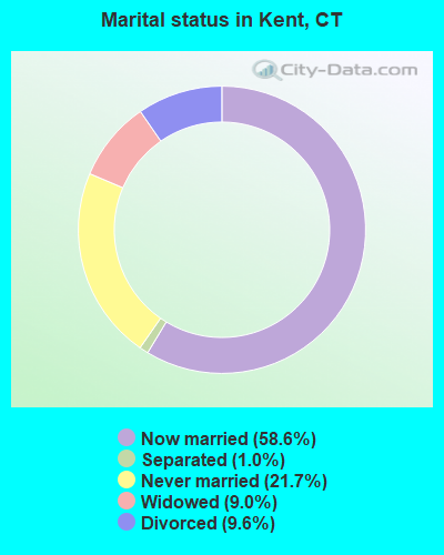
- Never married: 21.7%
- Now married: 58.6%
- Separated: 1.0%
- Widowed: 9.0%
- Divorced: 9.6%
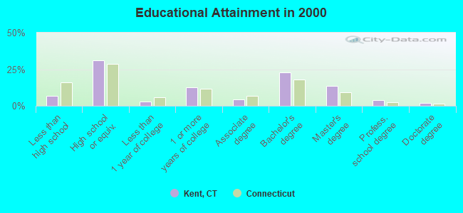
For population 25 years and over in Kent:
- High school or higher: 93.0%
- Bachelor's degree or higher: 42.0%
- Graduate or professional degree: 19.2%
- Unemployed: 3.3%
- Mean travel time to work (commute): 29.8 minutes
| Here: | 11.0 |
| Connecticut average: | 12.8 |
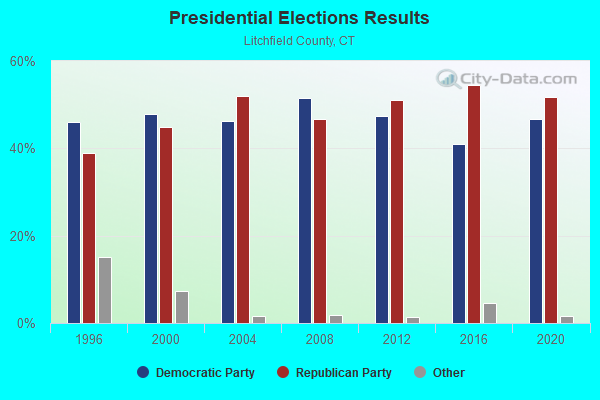
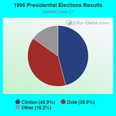
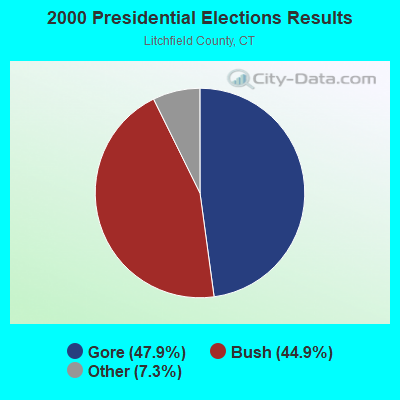
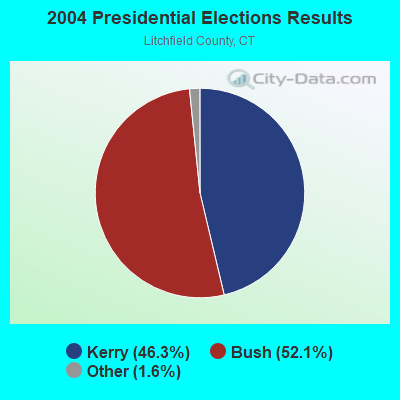
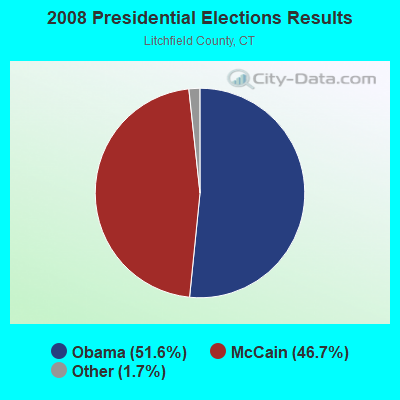
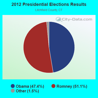
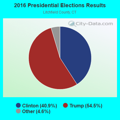
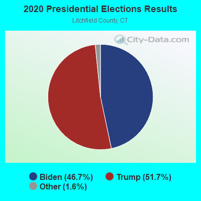
Graphs represent county-level data. Detailed 2008 Election Results
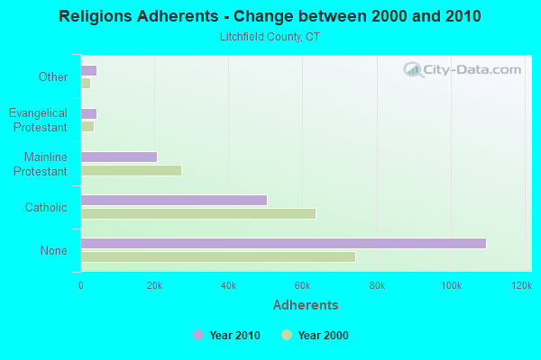
Religion statistics for Kent, CT (based on Litchfield County data)
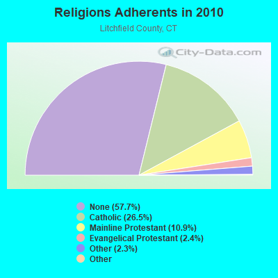
| Religion | Adherents | Congregations |
|---|---|---|
| Catholic | 50,354 | 30 |
| Mainline Protestant | 20,681 | 87 |
| Evangelical Protestant | 4,483 | 39 |
| Other | 4,420 | 16 |
| Orthodox | 175 | 2 |
| Black Protestant | 160 | 2 |
| None | 109,654 | - |
Food Environment Statistics:
| This county: | 2.29 / 10,000 pop. |
| State: | 2.21 / 10,000 pop. |
| Litchfield County: | 0.05 / 10,000 pop. |
| Connecticut: | 0.07 / 10,000 pop. |
| Litchfield County: | 0.64 / 10,000 pop. |
| Connecticut: | 1.02 / 10,000 pop. |
| Litchfield County: | 2.98 / 10,000 pop. |
| Connecticut: | 2.27 / 10,000 pop. |
| Here: | 11.07 / 10,000 pop. |
| Connecticut: | 9.19 / 10,000 pop. |
| Litchfield County: | 6.9% |
| Connecticut: | 7.3% |
| This county: | 21.1% |
| Connecticut: | 21.5% |
| Litchfield County: | 11.8% |
| Connecticut: | 15.8% |
| Businesses in Kent, CT | ||||
| Name | Count | Name | Count | |
|---|---|---|---|---|
| Curves | 1 | True Value | 1 | |
| FedEx | 1 | UPS | 1 | |
Strongest AM radio stations in Kent:
- WTIC (1080 AM; 50 kW; HARTFORD, CT; Owner: INFINITY RADIO OPERATIONS INC.)
- WNNZ (640 AM; 50 kW; WESTFIELD, MA; Owner: CLEAR CHANNEL BROADCASTING LICENSES, INC.)
- WFAN (660 AM; 50 kW; NEW YORK, NY; Owner: INFINITY BROADCASTING OPERATIONS, INC.)
- WCBS (880 AM; 50 kW; NEW YORK, NY; Owner: INFINITY BROADCASTING OPERATIONS, INC.)
- WMCA (570 AM; 50 kW; NEW YORK, NY; Owner: SALEM MEDIA OF NEW YORK, LLC)
- WABC (770 AM; 50 kW; NEW YORK, NY; Owner: WABC-AM RADIO, INC.)
- WOR (710 AM; 50 kW; NEW YORK, NY; Owner: BUCKLEY BROADCASTING CORPORATION)
- WINS (1010 AM; 50 kW; NEW YORK, NY; Owner: INFINITY BROADCASTING OPERATIONS, INC.)
- WEPN (1050 AM; 50 kW; NEW YORK, NY; Owner: NEW YORK AM RADIO, LLC)
- WGY (810 AM; 50 kW; SCHENECTADY, NY; Owner: CLEAR CHANNEL BROADCASTING LICENSES, INC.)
- WBBR (1130 AM; 50 kW; NEW YORK, NY; Owner: BLOOMBERG COMMUNICATIONS INC.)
- WGSM (740 AM; 25 kW; HUNTINGTON, NY; Owner: K RADIO LICENSEE, INC.)
- WADO (1280 AM; 50 kW; NEW YORK, NY; Owner: WADO-AM LICENSE CORP.)
Strongest FM radio stations in Kent:
- W206AW (89.1 FM; PAWLING, NY; Owner: SOUND OF LIFE, INC.)
- W218AV (91.5 FM; WARREN, CT; Owner: MONROE BOARD OF EDUCATION)
- WQQQ (103.3 FM; SHARON, CT; Owner: THE RIDGEFIELD BROADCASTING CORPORATION)
- WGSK (90.1 FM; SOUTH KENT, CT; Owner: MONROE BOARD OF EDUCATION)
- WRNQ (92.1 FM; POUGHKEEPSIE, NY; Owner: CLEAR CHANNEL BROADCASTING LICENSES, INC.)
- WPDH (101.5 FM; POUGHKEEPSIE, NY; Owner: CUMULUS LICENSING CORP.)
- WRKI (95.1 FM; BROOKFIELD, CT; Owner: CUMULUS LICENSING CORP.)
- WKZE-FM (98.1 FM; SALISBURY, CT; Owner: JOHNSON DEVELOPMENT, INC.)
- WFNP (88.7 FM; ROSENDALE, NY; Owner: STATE UNIVERSITY OF NEW YORK)
- WRHV (88.7 FM; POUGHKEEPSIE, NY; Owner: WMHT EDUCATIONAL TELECOMMUNICATIONS)
- WDBY (105.5 FM; PATTERSON, NY; Owner: CUMULUS LICENSING CORP.)
- WSPK (104.7 FM; POUGHKEEPSIE, NY; Owner: 6 JOHNSON ROAD LICENSES, INC.)
- WRCH (100.5 FM; NEW BRITAIN, CT; Owner: INFINITY RADIO OPERATIONS INC.)
- WCZX (97.7 FM; HYDE PARK, NY; Owner: CUMULUS LICENSING CORP.)
- WRRB (96.9 FM; ARLINGTON, NY; Owner: CUMULUS LICENSING CORP.)
- WBWZ (93.3 FM; NEW PALTZ, NY; Owner: CLEVELAND RADIO LICENSES, LLC)
- WRWD-FM (107.3 FM; HIGHLAND, NY; Owner: CLEVELAND RADIO LICENSES, LLC)
- WAMK (90.9 FM; KINGSTON, NY; Owner: W A M C)
- WFGB (89.7 FM; KINGSTON, NY; Owner: SOUND OF LIFE, INC.)
- WKCI-FM (101.3 FM; HAMDEN, CT; Owner: CLEAR CHANNEL BROADCASTING LICENSES, INC.)
TV broadcast stations around Kent:
- WTIC-TV (Channel 61; HARTFORD, CT; Owner: TRIBUNE TELEVISION COMPANY)
- W11BJ (Channel 11; HARTFORD, CT; Owner: COMMUNICATIONS SITE MANAGEMENT LLC)
- WTXX (Channel 20; WATERBURY, CT; Owner: WTXX INC.)
- WVIT (Channel 30; NEW BRITAIN, CT; Owner: OUTLET BROADCASTING, INC)
- WEDH (Channel 24; HARTFORD, CT; Owner: CONNECTICUT PUBLIC BROADCASTING, INC.)
- WUVN (Channel 18; HARTFORD, CT; Owner: ENTRAVISION HOLDINGS, LLC)
- WTBY (Channel 54; POUGHKEEPSIE, NY; Owner: TRINITY BROADCASTING OF NEW YORK, INC.)
- WTNH (Channel 8; NEW HAVEN, CT; Owner: WTNH BROADCASTING, INC.)
- WCTX (Channel 59; NEW HAVEN, CT; Owner: WTNH BROADCASTING, INC.)
- WEDY (Channel 65; NEW HAVEN, CT; Owner: CONNECTICUT PUBLIC BROADCASTING, INC.)
- National Bridge Inventory (NBI) Statistics
- 14Number of bridges
- 92ft / 28.3mTotal length
- $2,154,000Total costs
- 32,900Total average daily traffic
- 1,639Total average daily truck traffic
- 48,886Total future (year 2036) average daily traffic
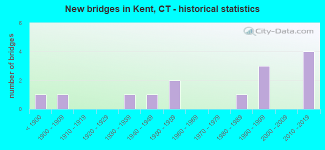
- New bridges - historical statistics
- 1Before 1900
- 11900-1909
- 11930-1939
- 11940-1949
- 21950-1959
- 11980-1989
- 31990-1999
- 42010-2019
FCC Registered Antenna Towers:
2- James E McDonald, 40 Bulls Bridge Road (Kent Site) (Lat: 41.681583 Lon: -73.486556), Type: 59.4, Overall height: 54.5 m, Registrant: Alltel Communications, Inc., Aci.Wireless.Regulatory@alltel.Com, , Littl-e Rock, Phone: (501) 905-8555
- James E McDonald, 40 Bulls Bridge Road (Kent Site) (Lat: 41.681583 Lon: -73.486556), Type: 59.4, Overall height: 54.5 m, Registrant: Alltel Communications, Inc., Aci.Wireless.Regulatory@alltel.Com, , Littl-e Rock, Phone: (501) 905-8555
FCC Registered Broadcast Land Mobile Towers:
10 (See the full list of FCC Registered Broadcast Land Mobile Towers in Kent, CT)FCC Registered Microwave Towers:
2- SKIFF MT, 476 Skiff Mountain Road (Lat: 41.780361 Lon: -73.456222), Type: Building, Structure height: 10.7 m, Call Sign: WPQZ281,
Assigned Frequencies: 933.575 MHz, Grant Date: 10/02/2010, Expiration Date: 12/11/2020, Cancellation Date: 02/13/2021, Certifier: Michael A Stemmler, Registrant: State Of Connecticut, 1111 Country Club Road, Middletown, CT 06457, Phone: (860) 685-8280, Fax: (860) 685-8345, Email:
- SKIFF MT, 476 Skiff Mt Rd (Lat: 41.783583 Lon: -73.457278), Type: Mtower, Structure height: 12.2 m, Call Sign: WRHS879,
Assigned Frequencies: 6605.00 MHz, Grant Date: 06/10/2020, Expiration Date: 06/10/2030, Certifier: Scott Wright, Registrant: 1111 Country Club Rd, Middletown, CT 06457, Phone: (860) 685-8080, Fax: (860) 685-8362, Email:
FCC Registered Amateur Radio Licenses:
8 (See the full list of FCC Registered Amateur Radio Licenses in Kent)FAA Registered Aircraft:
3- Aircraft: CONSOLIDATED AERONAUTICS INC. LAKE LA-4-200 (Category: Land, Seats: 4, Weight: Up to 12,499 Pounds, Speed: 112 mph), Engine: LYCOMING I0360 SER A&C (200 HP) (Reciprocating)
N-Number: 1259L, N1259L, N-1259L, Serial Number: 757, Year manufactured: 1976, Airworthiness Date: 05/25/1976, Certificate Issue Date: 11/07/2019
Registrant (LLC): Lakeflyers LLC, 18 Mauwee Brook Rd, Kent, CT 06757 - Aircraft: BEECH F33A (Category: Land, Seats: 5, Weight: Up to 12,499 Pounds, Speed: 138 mph), Engine: CONT MOTOR IO 520 SERIES (285 HP) (Reciprocating)
N-Number: 1859C, N1859C, N-1859C, Serial Number: CE-986, Year manufactured: 1981, Airworthiness Date: 11/24/1981, Certificate Issue Date: 09/04/2014
Registrant (LLC): Hadley Aviation LLC, 65 Tanguay Rd, Kent, CT 06757 - Aircraft: PIPER PA-28-180 (Category: Land, Seats: 4, Weight: Up to 12,499 Pounds, Speed: 107 mph), Engine: LYCOMING O&VO-360 SER (180 HP) (Reciprocating)
N-Number: 4907L, N4907L, N-4907L, Serial Number: 28-4222, Year manufactured: 1967, Airworthiness Date: 08/01/1967, Certificate Issue Date: 02/18/2014
Registrant (Co-Owned): Oscar P Duff, 360 Kent Cornwall Rd, Kent, CT 06757, Other Owners: David N Pearsall
2003 - 2018 National Fire Incident Reporting System (NFIRS) incidents
- Fire incident types reported to NFIRS in Kent, CT
- 12340.5%Outside Fires
- 11738.5%Structure Fires
- 3310.9%Other
- 3110.2%Mobile Property/Vehicle Fires
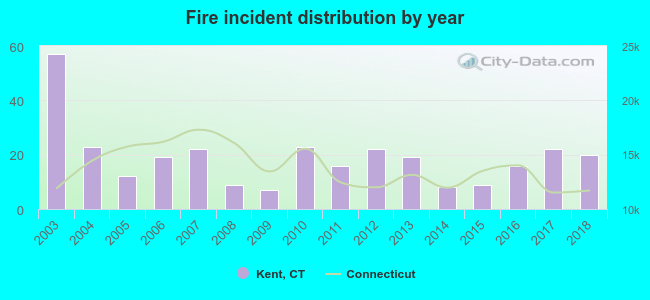 Based on the data from the years 2003 - 2018 the average number of fires per year is 19. The highest number of fires - 57 took place in 2003, and the least - 7 in 2009. The data has a dropping trend.
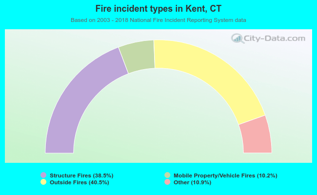 When looking into fire subcategories, the most incidents belonged to: Outside Fires (40.5%), and Structure Fires (38.5%).
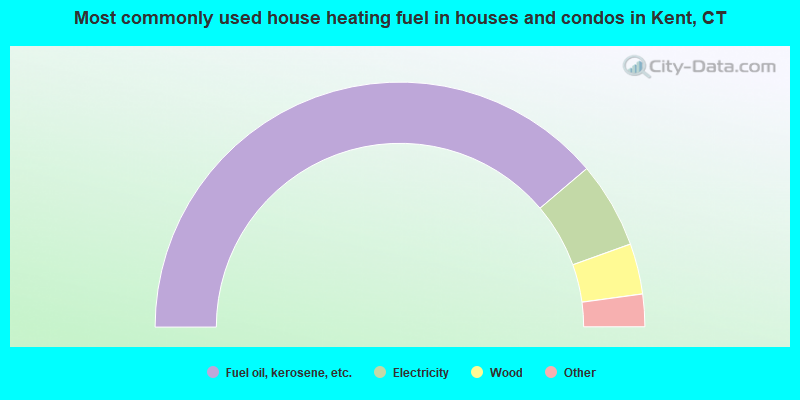
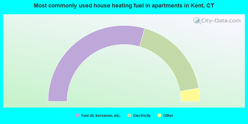
- 77.7%Fuel oil, kerosene, etc.
- 11.4%Electricity
- 6.7%Wood
- 2.7%Bottled, tank, or LP gas
- 1.1%Solar energy
- 0.5%Coal or coke
- 58.8%Fuel oil, kerosene, etc.
- 35.6%Electricity
- 3.3%Bottled, tank, or LP gas
- 2.3%Wood
Kent compared to Connecticut state average:
- Unemployed percentage significantly below state average.
- Black race population percentage significantly below state average.
- Hispanic race population percentage significantly below state average.
- Median age significantly above state average.
- Foreign-born population percentage below state average.
- Length of stay since moving in significantly above state average.
- Number of rooms per house significantly below state average.
- House age significantly below state average.
- Number of college students below state average.

|
|
Total of 31 patent applications in 2008-2024.