Brookfield, Connecticut
Submit your own pictures of this town and show them to the world
- OSM Map
- General Map
- Google Map
- MSN Map
Population change since 2000: +5.0%
 |
| Males: 7,964 | |
| Females: 8,488 |
| Median resident age: | 43.5 years |
| Connecticut median age: | 39.2 years |
Zip codes: 06804.
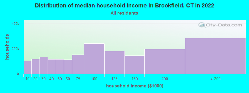
| Brookfield: | $135,600 |
| CT: | $88,429 |
Estimated per capita income in 2022: $66,459 (it was $37,063 in 2000)
Brookfield town income, earnings, and wages data
Estimated median house or condo value in 2022: $523,178 (it was $242,000 in 2000)
| Brookfield: | $523,178 |
| CT: | $347,200 |
Mean prices in 2022: all housing units: $773,995; detached houses: $872,764; townhouses or other attached units: $449,164; in 2-unit structures: $329,188; in 3-to-4-unit structures: $346,815; in 5-or-more-unit structures: $346,835; mobile homes: $65,227
Detailed information about poverty and poor residents in Brookfield, CT


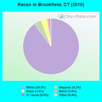
- 14,76689.8%White alone
- 7104.3%Hispanic
- 5953.6%Asian alone
- 1611.0%Black alone
- 1420.9%Two or more races
- 720.4%Other race alone
- 60.04%American Indian alone
Races in Brookfield detailed stats: ancestries, foreign born residents, place of birth
According to our research of Connecticut and other state lists, there were 3 registered sex offenders living in Brookfield, Connecticut as of May 08, 2024.
The ratio of all residents to sex offenders in Brookfield is 5,484 to 1.
The ratio of registered sex offenders to all residents in this city is much lower than the state average.
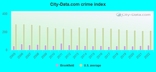
Type |
2009 |
2010 |
2011 |
2012 |
2013 |
2014 |
2015 |
2016 |
2017 |
2018 |
2019 |
2020 |
2021 |
2022 |
|---|---|---|---|---|---|---|---|---|---|---|---|---|---|---|
| Murders (per 100,000) | 0 (0.0) | 0 (0.0) | 0 (0.0) | 0 (0.0) | 0 (0.0) | 0 (0.0) | 0 (0.0) | 0 (0.0) | 0 (0.0) | 0 (0.0) | 0 (0.0) | 0 (0.0) | 0 (0.0) | 0 (0.0) |
| Rapes (per 100,000) | 0 (0.0) | 0 (0.0) | 1 (6.1) | 0 (0.0) | 0 (0.0) | 0 (0.0) | 0 (0.0) | 0 (0.0) | 0 (0.0) | 0 (0.0) | 1 (5.9) | 1 (5.9) | 1 (5.9) | 0 (0.0) |
| Robberies (per 100,000) | 2 (11.9) | 2 (12.2) | 5 (30.3) | 0 (0.0) | 0 (0.0) | 2 (11.8) | 1 (5.8) | 1 (5.8) | 1 (5.8) | 1 (5.8) | 1 (5.9) | 0 (0.0) | 1 (5.9) | 3 (17.2) |
| Assaults (per 100,000) | 3 (17.9) | 3 (18.2) | 4 (24.3) | 2 (12.0) | 9 (53.3) | 1 (5.9) | 5 (29.1) | 9 (52.1) | 2 (11.6) | 4 (23.2) | 2 (11.7) | 2 (11.7) | 6 (35.4) | 7 (40.0) |
| Burglaries (per 100,000) | 25 (149.1) | 38 (231.0) | 34 (206.3) | 36 (216.1) | 16 (94.8) | 19 (112.0) | 20 (116.3) | 22 (127.3) | 15 (87.2) | 8 (46.4) | 6 (35.1) | 7 (41.1) | 6 (35.4) | 10 (57.2) |
| Thefts (per 100,000) | 137 (817.1) | 103 (626.1) | 160 (970.8) | 149 (894.3) | 141 (835.1) | 139 (819.7) | 112 (651.1) | 96 (555.6) | 95 (552.2) | 143 (829.9) | 134 (785.0) | 105 (616.5) | 112 (661.0) | 129 (737.5) |
| Auto thefts (per 100,000) | 6 (35.8) | 1 (6.1) | 6 (36.4) | 6 (36.0) | 5 (29.6) | 4 (23.6) | 9 (52.3) | 9 (52.1) | 12 (69.8) | 7 (40.6) | 3 (17.6) | 15 (88.1) | 12 (70.8) | 12 (68.6) |
| Arson (per 100,000) | 1 (6.0) | 0 (0.0) | 0 (0.0) | 0 (0.0) | 0 (0.0) | 0 (0.0) | 1 (5.8) | 0 (0.0) | 0 (0.0) | 2 (11.6) | 0 (0.0) | 0 (0.0) | 0 (0.0) | 0 (0.0) |
| City-Data.com crime index | 53.1 | 49.0 | 75.0 | 56.2 | 53.1 | 47.2 | 45.9 | 47.5 | 37.8 | 46.1 | 44.1 | 41.6 | 48.2 | 52.1 |
The City-Data.com crime index weighs serious crimes and violent crimes more heavily. Higher means more crime, U.S. average is 246.1. It adjusts for the number of visitors and daily workers commuting into cities.
Crime rate in Brookfield detailed stats: murders, rapes, robberies, assaults, burglaries, thefts, arson
Full-time law enforcement employees in 2021, including police officers: 44 (34 officers - 32 male; 2 female).
| Officers per 1,000 residents here: | 2.01 |
| Connecticut average: | 2.10 |
 Recent articles from our blog. Our writers, many of them Ph.D. graduates or candidates, create easy-to-read articles on a wide variety of topics.


Latest news from Brookfield, CT collected exclusively by city-data.com from local newspapers, TV, and radio stations
Brookfield, CT City Guides:
Ancestries: Italian (25.7%), Irish (24.3%), German (17.5%), English (13.4%), Polish (7.2%), United States (3.8%).
Current Local Time: EST time zone
Incorporated on 05/1788
Elevation: 292 feet
Land area: 19.8 square miles.
Population density: 831 people per square mile (low).
1,278 residents are foreign born (4.4% Europe, 1.6% Latin America, 1.5% Asia).
| This town: | 8.2% |
| Connecticut: | 10.9% |
| Brookfield town: | 1.4% ($3,495) |
| Connecticut: | 1.8% ($2,961) |
Nearest city with pop. 50,000+: Danbury, CT  (5.3 miles , pop. 74,848).
Nearest city with pop. 200,000+: Bronx, NY (49.4 miles , pop. 1,332,650).
Nearest cities:
), ), Latitude: 41.47 N, Longitude: 73.40 W
Area code commonly used in this area: 203

Brookfield, Connecticut accommodation & food services, waste management - Economy and Business Data
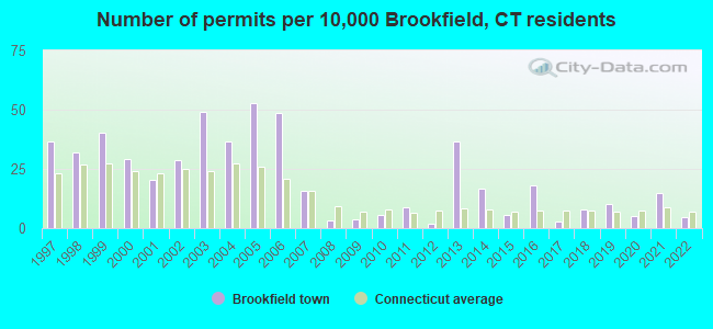
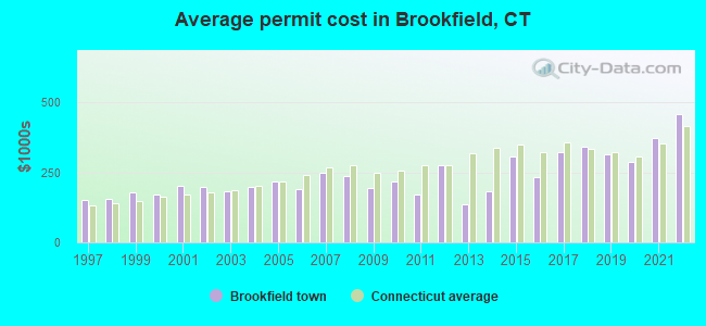
Single-family new house construction building permits:
- 2022: 7 buildings, average cost: $458,300
- 2021: 23 buildings, average cost: $370,800
- 2020: 8 buildings, average cost: $287,500
- 2019: 16 buildings, average cost: $313,900
- 2018: 12 buildings, average cost: $342,300
- 2017: 4 buildings, average cost: $324,200
- 2016: 28 buildings, average cost: $232,000
- 2015: 9 buildings, average cost: $307,300
- 2014: 26 buildings, average cost: $184,300
- 2013: 57 buildings, average cost: $134,400
- 2012: 3 buildings, average cost: $276,700
- 2011: 14 buildings, average cost: $172,000
- 2010: 9 buildings, average cost: $219,300
- 2009: 6 buildings, average cost: $195,200
- 2008: 5 buildings, average cost: $238,000
- 2007: 25 buildings, average cost: $248,400
- 2006: 76 buildings, average cost: $189,800
- 2005: 83 buildings, average cost: $218,900
- 2004: 57 buildings, average cost: $196,500
- 2003: 77 buildings, average cost: $181,300
- 2002: 45 buildings, average cost: $197,600
- 2001: 32 buildings, average cost: $202,400
- 2000: 46 buildings, average cost: $169,800
- 1999: 63 buildings, average cost: $177,400
- 1998: 50 buildings, average cost: $155,800
- 1997: 57 buildings, average cost: $152,200
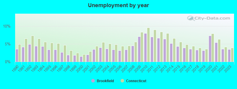
| Here: | 3.5% |
| Connecticut: | 3.9% |
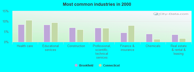
- Health care (8.5%)
- Educational services (8.4%)
- Construction (7.0%)
- Professional, scientific, technical services (6.9%)
- Finance & insurance (4.6%)
- Chemicals (4.0%)
- Real estate & rental & leasing (3.6%)
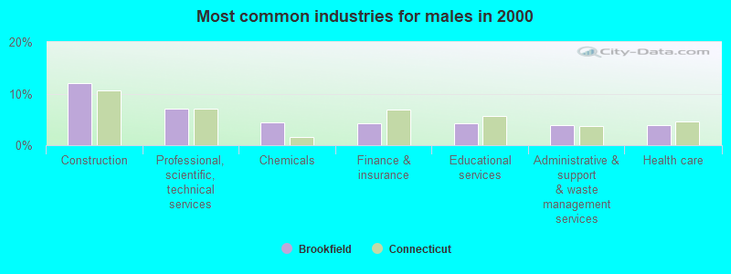
- Construction (12.0%)
- Professional, scientific, technical services (7.0%)
- Chemicals (4.4%)
- Finance & insurance (4.2%)
- Educational services (4.2%)
- Administrative & support & waste management services (3.9%)
- Health care (3.8%)
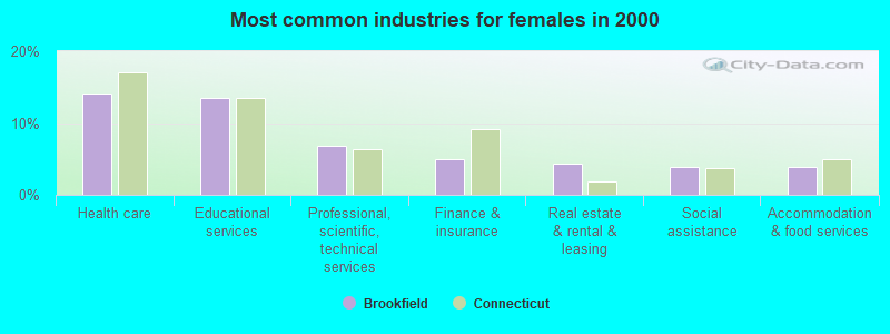
- Health care (14.2%)
- Educational services (13.4%)
- Professional, scientific, technical services (6.8%)
- Finance & insurance (5.0%)
- Real estate & rental & leasing (4.4%)
- Social assistance (3.9%)
- Accommodation & food services (3.8%)
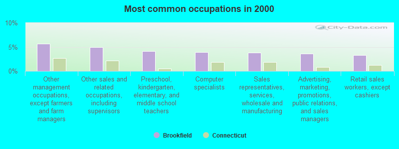
- Other management occupations, except farmers and farm managers (5.7%)
- Other sales and related occupations, including supervisors (5.0%)
- Preschool, kindergarten, elementary, and middle school teachers (4.2%)
- Computer specialists (3.9%)
- Sales representatives, services, wholesale and manufacturing (3.8%)
- Advertising, marketing, promotions, public relations, and sales managers (3.7%)
- Retail sales workers, except cashiers (3.3%)
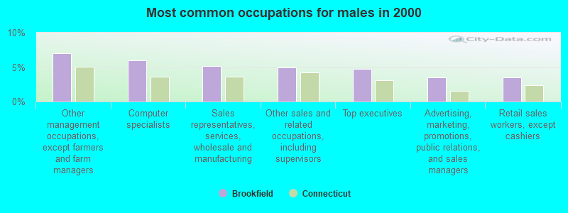
- Other management occupations, except farmers and farm managers (7.0%)
- Computer specialists (6.0%)
- Sales representatives, services, wholesale and manufacturing (5.2%)
- Other sales and related occupations, including supervisors (4.9%)
- Top executives (4.8%)
- Advertising, marketing, promotions, public relations, and sales managers (3.5%)
- Retail sales workers, except cashiers (3.5%)
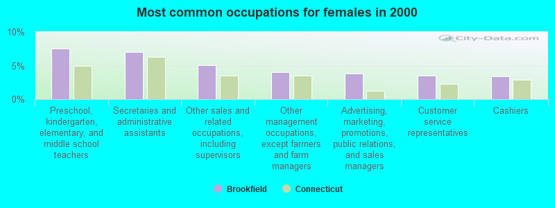
- Preschool, kindergarten, elementary, and middle school teachers (7.5%)
- Secretaries and administrative assistants (7.0%)
- Other sales and related occupations, including supervisors (5.0%)
- Other management occupations, except farmers and farm managers (4.1%)
- Advertising, marketing, promotions, public relations, and sales managers (3.8%)
- Customer service representatives (3.5%)
- Cashiers (3.4%)
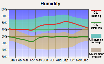
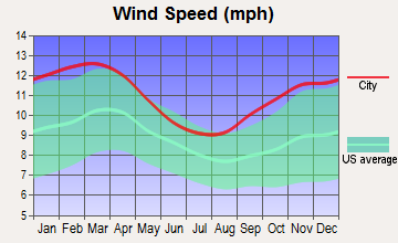
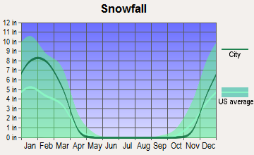
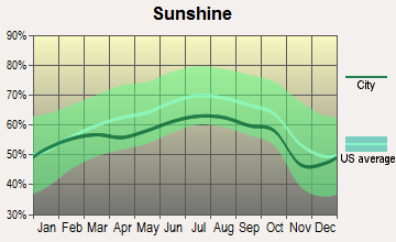
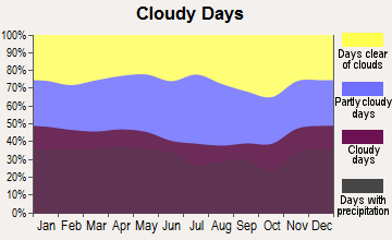
Average climate in Brookfield, Connecticut
Based on data reported by over 4,000 weather stations

(lower is better)
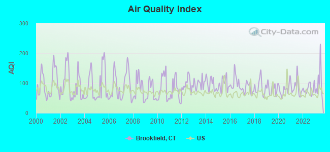
Air Quality Index (AQI) level in 2023 was 98.9. This is worse than average.
| City: | 98.9 |
| U.S.: | 72.6 |
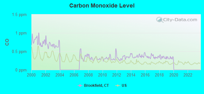
Carbon Monoxide (CO) [ppm] level in 2019 was 0.322. This is worse than average. Closest monitor was 19.4 miles away from the city center.
| City: | 0.322 |
| U.S.: | 0.251 |
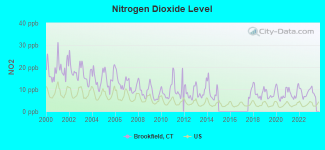
Nitrogen Dioxide (NO2) [ppb] level in 2022 was 8.39. This is significantly worse than average. Closest monitor was 5.0 miles away from the city center.
| City: | 8.39 |
| U.S.: | 5.11 |
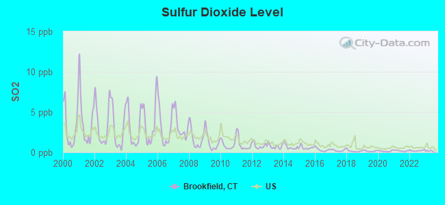
Sulfur Dioxide (SO2) [ppb] level in 2022 was 0.221. This is significantly better than average. Closest monitor was 5.0 miles away from the city center.
| City: | 0.221 |
| U.S.: | 1.515 |
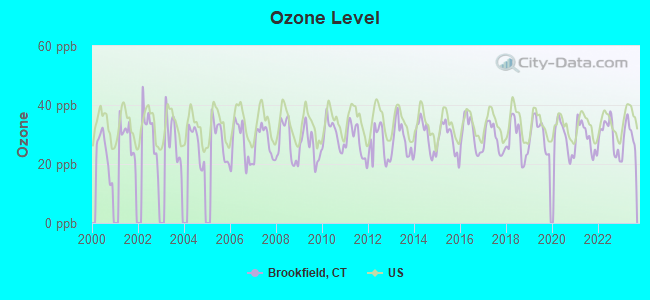
Ozone [ppb] level in 2023 was 29.5. This is about average. Closest monitor was 5.1 miles away from the city center.
| City: | 29.5 |
| U.S.: | 33.3 |
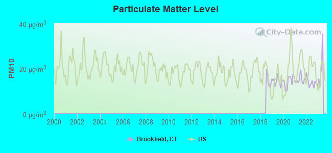
Particulate Matter (PM10) [µg/m3] level in 2022 was 13.9. This is better than average. Closest monitor was 5.1 miles away from the city center.
| City: | 13.9 |
| U.S.: | 19.2 |

Particulate Matter (PM2.5) [µg/m3] level in 2022 was 7.23. This is about average. Closest monitor was 5.1 miles away from the city center.
| City: | 7.23 |
| U.S.: | 8.11 |
Tornado activity:
Brookfield-area historical tornado activity is near Connecticut state average. It is 29% smaller than the overall U.S. average.
On 7/10/1989, a category F4 (max. wind speeds 207-260 mph) tornado 26.6 miles away from the Brookfield town center injured 40 people and caused between $50,000,000 and $500,000,000 in damages.
On 5/24/1962, a category F3 (max. wind speeds 158-206 mph) tornado 15.6 miles away from the town center killed one person and injured 50 people and caused between $500,000 and $5,000,000 in damages.
Earthquake activity:
Brookfield-area historical earthquake activity is significantly above Connecticut state average. It is 69% smaller than the overall U.S. average.On 10/7/1983 at 10:18:46, a magnitude 5.3 (5.1 MB, 5.3 LG, 5.1 ML, Class: Moderate, Intensity: VI - VII) earthquake occurred 178.6 miles away from the city center
On 4/20/2002 at 10:50:47, a magnitude 5.3 (5.3 ML, Depth: 3.0 mi) earthquake occurred 211.3 miles away from Brookfield center
On 4/20/2002 at 10:50:47, a magnitude 5.2 (5.2 MB, 4.2 MS, 5.2 MW, 5.0 MW) earthquake occurred 209.6 miles away from the city center
On 8/23/2011 at 17:51:04, a magnitude 5.8 (5.8 MW, Depth: 3.7 mi) earthquake occurred 344.6 miles away from the city center
On 1/19/1982 at 00:14:42, a magnitude 4.7 (4.5 MB, 4.7 MD, 4.5 LG, Class: Light, Intensity: IV - V) earthquake occurred 168.0 miles away from Brookfield center
On 1/16/1994 at 01:49:16, a magnitude 4.6 (4.6 MB, 4.6 LG, Depth: 3.1 mi) earthquake occurred 158.7 miles away from the city center
Magnitude types: regional Lg-wave magnitude (LG), body-wave magnitude (MB), duration magnitude (MD), local magnitude (ML), surface-wave magnitude (MS), moment magnitude (MW)
Natural disasters:
The number of natural disasters in Fairfield County (24) is greater than the US average (15).Major Disasters (Presidential) Declared: 13
Emergencies Declared: 11
Causes of natural disasters: Storms: 6, Floods: 5, Hurricanes: 5, Snowstorms: 4, Blizzards: 3, Snows: 3, Winter Storms: 3, Tropical Storms: 2, Snowfall: 1, Wind: 1 (Note: some incidents may be assigned to more than one category).

Main business address for: PHOTRONICS INC (SEMICONDUCTORS & RELATED DEVICES).
Hospitals and medical centers in Brookfield:
Colleges/universities with over 2000 students nearest to Brookfield:
- Western Connecticut State University (about 6 miles; Danbury, CT; Full-time enrollment: 5,345)
- Post University (about 18 miles; Waterbury, CT; FT enrollment: 5,808)
- Naugatuck Valley Community College (about 18 miles; Waterbury, CT; FT enrollment: 4,491)
- Sacred Heart University (about 19 miles; Fairfield, CT; FT enrollment: 5,650)
- University of Connecticut-Tri-Campus (about 20 miles; Waterbury, CT; FT enrollment: 2,250)
- Fairfield University (about 23 miles; Fairfield, CT; FT enrollment: 4,640)
- Housatonic Community College (about 23 miles; Bridgeport, CT; FT enrollment: 3,677)
Public high school in Brookfield:
- BROOKFIELD HIGH SCHOOL (Students: 721, Location: 45 LONG MEADOW HILL ROAD, Grades: 9-12)
Public elementary/middle schools in Brookfield:
- WHISCONIER MIDDLE SCHOOL (Students: 1,037, Location: 17 WEST WHISCONIER ROAD, Grades: 5-8)
- HUCKLEBERRY HILL ELEMENTARY SCHOOL (Students: 691, Location: 100 CANDLEWOOD LAKE ROAD, Grades: 2-4)
- CENTER ELEMENTARY SCHOOL (Students: 629, Location: 8 OBTUSE HILL, Grades: PK-1)
Private elementary/middle schools in Brookfield:
User-submitted facts and corrections:
- Private primary/middle schools in Brookfield: Saint Joseph School Students: 175; Location: Rt. 133 5 Obtuse Hill Road; Grades: PK - 8
Points of interest:
Notable locations in Brookfield: Silvermine Industrial Park (A), Brookfield Golf Course (B), Candlewood Boat and Beach Club (C), Brookfield Office Park (D), Brookfield Craft Center (E), Brookfield Town Office (F), Brookfield Library (G), Brookfield Historical Society Building (H), Brookfield Emergency Medical Services (I), Candlewood Company (J), Brookfield Volunteer Fire Company (K), Brookfield Fire Marshal's Office (L). Display/hide their locations on the map
Shopping Centers: White Turkey Plaza Shopping Center (1), Colonial Square Shopping Center (2), Candlewood Plaza Shopping Center (3), Caldor Shopping Center (4), Brookfield Park Shopping Center (5), Brook Center Shopping Center (6). Display/hide their locations on the map
Main business address in Brookfield: PHOTRONICS INC (A). Display/hide its location on the map
Churches in Brookfield include: Newbury Congregational Church (A), Saint Josephs Brookfield Church (B), Saint Marguerite Bourgeoys Church (C), Valley Presbyterian Church (D). Display/hide their locations on the map
Cemeteries: Central Cemetery (1), Laure Hill Cemetery (2), United Jewish Center Cemetery (3). Display/hide their locations on the map
Swamps: Bound Swamp (A). Display/hide its location on the map
Streams, rivers, and creeks: Limekiln Brook (A), Mann Brook (B), Merwin Brook (C), West Brook (D), East Brook (E), Fred Beers Brook (F), Hop Brook (G). Display/hide their locations on the map
Parks in Brookfield include: Williams Park (1), Lions Park (2). Display/hide their locations on the map
Tourist attractions: Brookfield Historical Society Inc (Museums; 253 Whisconier Road) (1), Kids Club (Amusement & Theme Parks; 94 Old State Road) (2). Display/hide their approximate locations on the map
Birthplace of: Kari Wührer - Actress, Julia DeMato - Female singer.
Drinking water stations with addresses in Brookfield and their reported violations in the past:
CLC OWNERS CORPORATION (Population served: 736, Groundwater):Past health violations:STONY HILL VILLAGE (Population served: 392, Groundwater):Past monitoring violations:
- MCL, Monthly (TCR) - In OCT-2009, Contaminant: Coliform. Follow-up actions: St Public Notif requested (NOV-02-2009), St Violation/Reminder Notice (NOV-02-2009), St Public Notif received (NOV-16-2009), St Compliance achieved (NOV-30-2009)
- MCL, Monthly (TCR) - In AUG-2009, Contaminant: Coliform. Follow-up actions: St Public Notif requested (SEP-01-2009), St Violation/Reminder Notice (SEP-01-2009), St Public Notif received (SEP-14-2009), St Compliance achieved (SEP-30-2009)
- MCL, Monthly (TCR) - In OCT-2008, Contaminant: Coliform. Follow-up actions: St Public Notif requested (NOV-12-2008), St Violation/Reminder Notice (NOV-12-2008), St Compliance achieved (NOV-30-2008), St Public Notif received (DEC-08-2008)
- One routine major monitoring violation
- 98 regular monitoring violations
Past health violations:ARROWHEAD POINT HOMEOWNERS ASSN INC. (Population served: 296, Groundwater):Past monitoring violations:
- MCL, Average - Between JUL-2014 and SEP-2014, Contaminant: Gross Alpha, Excl. Radon and U. Follow-up actions: St Violation/Reminder Notice (SEP-25-2014), St Public Notif requested (SEP-25-2014)
- MCL, Average - Between JUL-2014 and SEP-2014, Contaminant: Combined Uranium. Follow-up actions: St Violation/Reminder Notice (SEP-25-2014), St Public Notif requested (SEP-25-2014)
- MCL, Average - Between APR-2014 and JUN-2014, Contaminant: Combined Uranium. Follow-up actions: St Public Notif requested (JUL-01-2014), St Violation/Reminder Notice (JUL-01-2014), St Public Notif received (JUL-14-2014)
- MCL, Average - Between OCT-2013 and DEC-2013, Contaminant: Gross Alpha, Excl. Radon and U. Follow-up actions: St Public Notif requested (DEC-27-2013), St Violation/Reminder Notice (DEC-27-2013), St Public Notif received (JAN-16-2014), St Compliance achieved (MAR-31-2014)
- MCL, Average - Between JUL-2013 and SEP-2013, Contaminant: Gross Alpha, Excl. Radon and U. Follow-up actions: St Public Notif requested (SEP-30-2013), St Violation/Reminder Notice (SEP-30-2013), St Public Notif received (JAN-24-2014), St Compliance achieved (MAR-31-2014)
- MCL, Average - Between APR-2008 and JUN-2008, Contaminant: Combined Uranium. Follow-up actions: St Public Notif requested (SEP-11-2008), St Violation/Reminder Notice (SEP-11-2008), St Public Notif received (SEP-16-2008), St Compliance achieved (SEP-30-2008)
- MCL, Average - Between JAN-2008 and MAR-2008, Contaminant: Combined Uranium. Follow-up actions: St Public Notif requested (MAY-01-2008), St Violation/Reminder Notice (MAY-01-2008), St Public Notif received (MAY-08-2008), St Compliance achieved (SEP-30-2008)
- 12 regular monitoring violations
Past health violations:CANDLEWOOD ORCHARDS PROPERTY OWNERS CORP (Population served: 144, Groundwater):Past monitoring violations:
- MCL, Monthly (TCR) - In SEP-2006, Contaminant: Coliform. Follow-up actions: St Public Notif requested (OCT-10-2006), St Violation/Reminder Notice (OCT-10-2006), St Public Notif received (OCT-19-2006), St Compliance achieved (MAR-31-2007)
- One routine major monitoring violation
- 29 regular monitoring violations
Past health violations:HICKORY HILLS (Population served: 132, Groundwater):
- MCL, Monthly (TCR) - In FEB-2007, Contaminant: Coliform. Follow-up actions: St Public Notif requested (FEB-28-2007), St Violation/Reminder Notice (FEB-28-2007), St Compliance achieved (SEP-30-2007)
- MCL, Monthly (TCR) - In JAN-2007, Contaminant: Coliform. Follow-up actions: St Public Notif requested (JAN-17-2007), St Violation/Reminder Notice (JAN-17-2007), St Public Notif received (FEB-26-2007), St Compliance achieved (SEP-30-2007)
- MCL, Monthly (TCR) - In SEP-2006, Contaminant: Coliform. Follow-up actions: St Public Notif requested (OCT-10-2006), St Violation/Reminder Notice (OCT-17-2006), St Public Notif received (MAR-02-2007), St Compliance achieved (SEP-30-2007)
- MCL, Monthly (TCR) - In AUG-2006, Contaminant: Coliform. Follow-up actions: St Public Notif requested (AUG-23-2006), St Violation/Reminder Notice (AUG-23-2006), St Public Notif received (MAR-02-2007), St Compliance achieved (SEP-30-2007)
- MCL, Monthly (TCR) - In JUL-2006, Contaminant: Coliform. Follow-up actions: St Public Notif requested (JUL-21-2006), St Violation/Reminder Notice (JUL-21-2006), St Public Notif received (AUG-01-2006), St Compliance achieved (SEP-30-2007)
- MCL, Monthly (TCR) - In JUN-2006, Contaminant: Coliform. Follow-up actions: St Public Notif requested (JUN-30-2006), St Violation/Reminder Notice (JUN-30-2006), St Public Notif received (NOV-15-2006), St Compliance achieved (SEP-30-2007)
- 5 other older health violations
Past health violations:LAKE LILLINONAH SHORES CONDOS (Population served: 130, Groundwater):
- MCL, Monthly (TCR) - Between JUL-2006 and SEP-2006, Contaminant: Coliform. Follow-up actions: St Public Notif received (JUL-27-2006), St Public Notif requested (AUG-04-2006), St Violation/Reminder Notice (AUG-04-2006), St Compliance achieved (MAR-31-2007)
Past health violations:BROOKFIELD ELDERLY HOUSING (Population served: 37, Groundwater):Past monitoring violations:
- MCL, Average - Between JAN-2008 and MAR-2008, Contaminant: Combined Uranium. Follow-up actions: St Public Notif requested (MAY-01-2008), St Violation/Reminder Notice (MAY-01-2008), St Public Notif received (MAY-22-2008), St Compliance achieved (JUN-30-2008)
- MCL, Average - Between OCT-2007 and DEC-2007, Contaminant: Combined Uranium. Follow-up actions: St Public Notif requested (JAN-29-2008), St Violation/Reminder Notice (JAN-29-2008), St Compliance achieved (JUN-30-2008), St Public Notif received (JUL-15-2008)
- MCL, Average - Between JUL-2007 and SEP-2007, Contaminant: Combined Uranium. Follow-up actions: St Public Notif requested (OCT-18-2007), St Violation/Reminder Notice (OCT-18-2007), St Compliance achieved (JUN-30-2008)
- MCL, Average - Between APR-2007 and JUN-2007, Contaminant: Combined Uranium. Follow-up actions: St Public Notif requested (JUL-12-2007), St Violation/Reminder Notice (JUL-12-2007), St Public Notif received (AUG-08-2007), St Compliance achieved (JUN-30-2008)
- MCL, Average - Between JAN-2007 and MAR-2007, Contaminant: Combined Uranium. Follow-up actions: St Public Notif requested (JUN-20-2007), St Violation/Reminder Notice (JUN-20-2007), St Public Notif received (AUG-08-2007), St Compliance achieved (JUN-30-2008)
- MCL, Average - Between OCT-2006 and DEC-2006, Contaminant: Combined Uranium. Follow-up actions: St Public Notif requested (APR-09-2007), St Violation/Reminder Notice (APR-09-2007), St Public Notif received (MAY-16-2007), St Compliance achieved (JUN-30-2008)
- MCL, Average - Between JUL-2006 and SEP-2006, Contaminant: Combined Uranium. Follow-up actions: St Public Notif requested (JAN-09-2007), St Violation/Reminder Notice (JAN-09-2007), St Public Notif received (FEB-14-2007), St Compliance achieved (JUN-30-2008)
- 21 regular monitoring violations
Past health violations:39 HOP BROOK RD - APT COMPLEX (Population served: 36, Groundwater):Past monitoring violations:
- MCL, Monthly (TCR) - In JUL-2009, Contaminant: Coliform. Follow-up actions: St Public Notif requested (AUG-10-2009), St Violation/Reminder Notice (AUG-10-2009), St Compliance achieved (AUG-31-2009), St Public Notif received (AUG-05-2010)
- MCL, Monthly (TCR) - Between APR-2005 and JUN-2005, Contaminant: Coliform. Follow-up actions: St Public Notif requested (JUN-09-2005), St Violation/Reminder Notice (JUN-09-2005), St Public Notif received (JUN-23-2005), St Compliance achieved (MAR-31-2006)
- 2 routine major monitoring violations
Past monitoring violations:
- Initial Tap Sampling for Pb and Cu - In JUL-01-2014, Contaminant: Lead and Copper Rule
- Initial Tap Sampling for Pb and Cu - In JUL-01-2012, Contaminant: Lead and Copper Rule. Follow-up actions: St Admin Penalty assessed (NOV-05-2012), St Formal NOV issued (NOV-05-2012), St Public Notif requested (NOV-05-2012), St Public Notif received (NOV-26-2012), St Compliance achieved (DEC-28-2012)
- One routine major monitoring violation
- 323 regular monitoring violations
| This town: | 2.7 people |
| Connecticut: | 2.5 people |
| This town: | 74.2% |
| Whole state: | 66.3% |
| This town: | 4.2% |
| Whole state: | 6.6% |
Likely homosexual households (counted as self-reported same-sex unmarried-partner households)
- Lesbian couples: 0.4% of all households
- Gay men: 0.3% of all households
| This town: | 2.3% |
| Whole state: | 7.9% |
| This town: | 1.1% |
| Whole state: | 3.9% |
9 people in residential treatment centers for adults in 2010
People in group quarters in Brookfield in 2000:
- 64 people in other group homes
- 10 people in homes for the mentally retarded
- 4 people in religious group quarters
Banks with branches in Brookfield (2011 data):
- Union Savings Bank: Brookfield Ii Branch at 828 Federal Rd, branch established on 1996/03/02; Brookfield Branch at 200 Federal Road, branch established on 1973/05/31. Info updated 2011/11/30: Bank assets: $2,496.5 mil, Deposits: $1,625.1 mil, headquarters in Danbury, CT, positive income, Mortgage Lending Specialization, 29 total offices
- Webster Bank, National Association: Brookfield Branch at 46 Federal Rd., branch established on 1971/07/01; Brookfield Branch at 46 Federal Road, branch established on 1964/09/15. Info updated 2008/12/23: Bank assets: $18,674.3 mil, Deposits: $13,861.5 mil, headquarters in Waterbury, CT, positive income, Commercial Lending Specialization, 167 total offices, Holding Company: Webster Financial Corporation
- Bank of America, National Association: Caldor Shopping Ctr Branch at 100 Federal Road (Rte 202), branch established on 1964/12/05. Info updated 2009/11/18: Bank assets: $1,451,969.3 mil, Deposits: $1,077,176.8 mil, headquarters in Charlotte, NC, positive income, 5782 total offices, Holding Company: Bank Of America Corporation
- Savings Bank of Danbury: Caldor Shopping Center Branch at 154 Federal Road, branch established on 1985/11/22. Info updated 2006/11/03: Bank assets: $762.3 mil, Deposits: $611.3 mil, headquarters in Danbury, CT, positive income, Commercial Lending Specialization, 13 total offices
- People's United Bank: Brookfield Branch at 143 Federal Road, branch established on 1974/12/05. Info updated 2012/02/16: Bank assets: $27,319.3 mil, Deposits: $20,835.4 mil, headquarters in Bridgeport, CT, positive income, Commercial Lending Specialization, 374 total offices
- Newtown Savings Bank: Brookfield Branch at 99 Federal Road, branch established on 2006/03/27. Info updated 2012/01/26: Bank assets: $955.5 mil, Deposits: $704.6 mil, headquarters in Newtown, CT, positive income, Commercial Lending Specialization, 19 total offices
- Hudson City Savings Bank: Brookfield Branch at 247 Federal Road, branch established on 2006/07/14. Info updated 2012/01/09: Bank assets: $45,373.6 mil, Deposits: $25,645.6 mil, headquarters in Paramus, NJ, negative income in the last year, Mortgage Lending Specialization, 135 total offices
- Citibank, National Association: Danbury Branch at 132 Federal Rd, branch established on 2006/08/07. Info updated 2012/01/10: Bank assets: $1,288,658.0 mil, Deposits: $882,541.0 mil, headquarters in Sioux Falls, SD, positive income, International Specialization, 1048 total offices, Holding Company: Citigroup Inc.
For population 15 years and over in Brookfield:
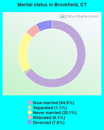
- Never married: 20.1%
- Now married: 64.9%
- Separated: 1.1%
- Widowed: 6.1%
- Divorced: 7.8%
For population 25 years and over in Brookfield:
- High school or higher: 93.4%
- Bachelor's degree or higher: 43.9%
- Graduate or professional degree: 18.0%
- Unemployed: 2.7%
- Mean travel time to work (commute): 30.2 minutes

| Here: | 10.1 |
| Connecticut average: | 12.8 |
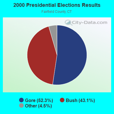
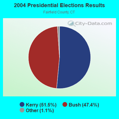
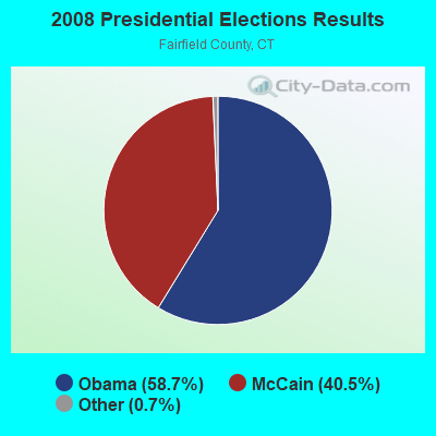
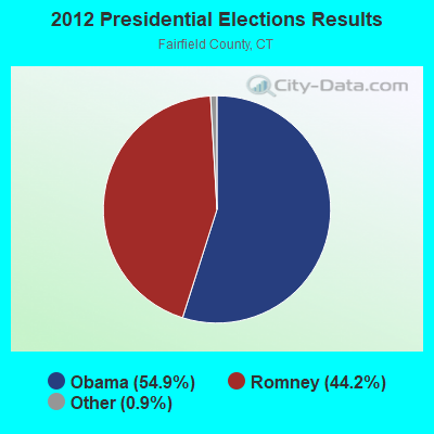
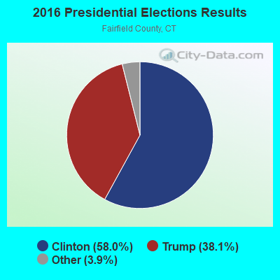
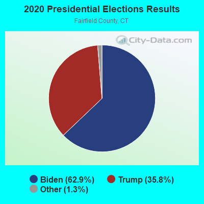
Graphs represent county-level data. Detailed 2008 Election Results
Religion statistics for Brookfield, CT (based on Fairfield County data)
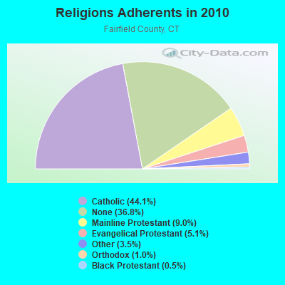
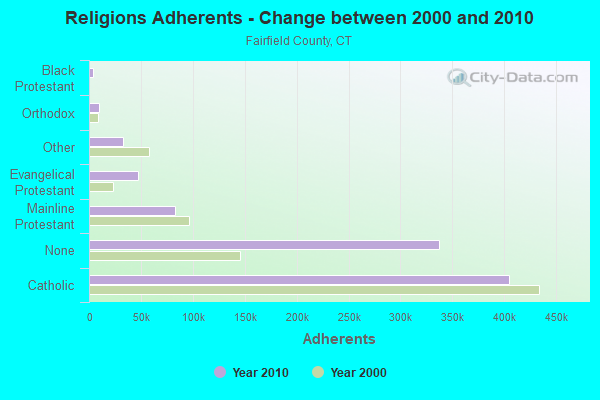
| Religion | Adherents | Congregations |
|---|---|---|
| Catholic | 404,341 | 94 |
| Mainline Protestant | 82,604 | 175 |
| Evangelical Protestant | 46,888 | 242 |
| Other | 32,501 | 95 |
| Orthodox | 9,215 | 21 |
| Black Protestant | 4,144 | 27 |
| None | 337,136 | - |
Food Environment Statistics:
| Fairfield County: | 2.50 / 10,000 pop. |
| Connecticut: | 2.21 / 10,000 pop. |
| This county: | 0.06 / 10,000 pop. |
| State: | 0.07 / 10,000 pop. |
| Fairfield County: | 0.85 / 10,000 pop. |
| Connecticut: | 1.02 / 10,000 pop. |
| Fairfield County: | 1.70 / 10,000 pop. |
| State: | 2.27 / 10,000 pop. |
| Here: | 9.67 / 10,000 pop. |
| State: | 9.19 / 10,000 pop. |
| This county: | 6.5% |
| Connecticut: | 7.3% |
| Fairfield County: | 17.9% |
| Connecticut: | 21.5% |
| This county: | 17.2% |
| State: | 15.8% |
5.92% of this county's 2021 resident taxpayers lived in other counties in 2020 ($194,373 average adjusted gross income)
| Here: | 5.92% |
| Connecticut average: | 5.79% |
0.01% of residents moved from foreign countries ($50 average AGI)
Fairfield County: 0.01% Connecticut average: 0.02%
Top counties from which taxpayers relocated into this county between 2020 and 2021:
| from Westchester County, NY | |
| from New York County, NY | |
| from New Haven County, CT |
6.13% of this county's 2020 resident taxpayers moved to other counties in 2021 ($174,109 average adjusted gross income)
| Here: | 6.13% |
| Connecticut average: | 5.82% |
0.01% of residents moved to foreign countries ($428 average AGI)
Fairfield County: 0.01% Connecticut average: 0.02%
Top counties to which taxpayers relocated from this county between 2020 and 2021:
| to New Haven County, CT | |
| to New York County, NY | |
| to Westchester County, NY |
| Businesses in Brookfield, CT | ||||
| Name | Count | Name | Count | |
|---|---|---|---|---|
| AutoZone | 1 | OfficeMax | 1 | |
| Bed Bath & Beyond | 1 | Panera Bread | 1 | |
| Burger King | 1 | Pizza Hut | 1 | |
| Costco | 1 | Raymour & Flanigan | 1 | |
| Dunkin Donuts | 3 | Rite Aid | 1 | |
| FedEx | 4 | Subway | 1 | |
| Firestone Complete Auto Care | 1 | T-Mobile | 1 | |
| GNC | 1 | T.J.Maxx | 1 | |
| Kohl's | 1 | The Room Place | 2 | |
| La-Z-Boy | 2 | UPS | 3 | |
| MasterBrand Cabinets | 2 | Verizon Wireless | 1 | |
| McDonald's | 1 | Wendy's | 1 | |
| New Balance | 1 | YMCA | 3 | |
| Nike | 3 | |||
Strongest AM radio stations in Brookfield:
- WINE (940 AM; 1 kW; BROOKFIELD, CT; Owner: CUMULUS LICENSING CORP.)
- WFAN (660 AM; 50 kW; NEW YORK, NY; Owner: INFINITY BROADCASTING OPERATIONS, INC.)
- WTIC (1080 AM; 50 kW; HARTFORD, CT; Owner: INFINITY RADIO OPERATIONS INC.)
- WCBS (880 AM; 50 kW; NEW YORK, NY; Owner: INFINITY BROADCASTING OPERATIONS, INC.)
- WABC (770 AM; 50 kW; NEW YORK, NY; Owner: WABC-AM RADIO, INC.)
- WMCA (570 AM; 50 kW; NEW YORK, NY; Owner: SALEM MEDIA OF NEW YORK, LLC)
- WNNZ (640 AM; 50 kW; WESTFIELD, MA; Owner: CLEAR CHANNEL BROADCASTING LICENSES, INC.)
- WOR (710 AM; 50 kW; NEW YORK, NY; Owner: BUCKLEY BROADCASTING CORPORATION)
- WGSM (740 AM; 25 kW; HUNTINGTON, NY; Owner: K RADIO LICENSEE, INC.)
- WREF (850 AM; 2 kW; RIDGEFIELD, CT; Owner: THE BERKSHIRE BROADCASTING CORP.)
- WADS (690 AM; daytime; 3 kW; ANSONIA, CT; Owner: RADIO AMOR, INC.)
- WEPN (1050 AM; 50 kW; NEW YORK, NY; Owner: NEW YORK AM RADIO, LLC)
- WINS (1010 AM; 50 kW; NEW YORK, NY; Owner: INFINITY BROADCASTING OPERATIONS, INC.)
Strongest FM radio stations in Brookfield:
- WRKI (95.1 FM; BROOKFIELD, CT; Owner: CUMULUS LICENSING CORP.)
- WDAQ (98.3 FM; DANBURY, CT; Owner: BERKSHIRE BROADCASTING CORP.)
- WXCI (91.7 FM; DANBURY, CT; Owner: WESTERN CONNECTICUT STATE UNIVERSITY)
- WFAR (93.3 FM; DANBURY, CT; Owner: DANBURY COMMUNITY RADIO, INC.)
- WDBY (105.5 FM; PATTERSON, NY; Owner: CUMULUS LICENSING CORP.)
- WKCI-FM (101.3 FM; HAMDEN, CT; Owner: CLEAR CHANNEL BROADCASTING LICENSES, INC.)
- WEZN-FM (99.9 FM; BRIDGEPORT, CT; Owner: CXR HOLDINGS, INC.)
- WSPK (104.7 FM; POUGHKEEPSIE, NY; Owner: 6 JOHNSON ROAD LICENSES, INC.)
- WPLR (99.1 FM; NEW HAVEN, CT; Owner: COX RADIO, INC.)
- W206AW (89.1 FM; PAWLING, NY; Owner: SOUND OF LIFE, INC.)
- WSHU-FM (91.1 FM; FAIRFIELD, CT; Owner: SACRED HEART UNIVERSITY, INC.)
- WMNR (88.1 FM; MONROE, CT; Owner: MONROE BOARD OF EDUCATION)
- WRNQ (92.1 FM; POUGHKEEPSIE, NY; Owner: CLEAR CHANNEL BROADCASTING LICENSES, INC.)
- WPDH (101.5 FM; POUGHKEEPSIE, NY; Owner: CUMULUS LICENSING CORP.)
- WPKN (89.5 FM; BRIDGEPORT, CT; Owner: WPKN, INC.)
- WRCH (100.5 FM; NEW BRITAIN, CT; Owner: INFINITY RADIO OPERATIONS INC.)
- WRXC (90.1 FM; SHELTON, CT; Owner: MONROE BOARD OF EDUCATION)
- WFNP (88.7 FM; ROSENDALE, NY; Owner: STATE UNIVERSITY OF NEW YORK)
- WRHV (88.7 FM; POUGHKEEPSIE, NY; Owner: WMHT EDUCATIONAL TELECOMMUNICATIONS)
- W218AV (91.5 FM; WARREN, CT; Owner: MONROE BOARD OF EDUCATION)
TV broadcast stations around Brookfield:
- WTIC-TV (Channel 61; HARTFORD, CT; Owner: TRIBUNE TELEVISION COMPANY)
- W11BJ (Channel 11; HARTFORD, CT; Owner: COMMUNICATIONS SITE MANAGEMENT LLC)
- WTNH (Channel 8; NEW HAVEN, CT; Owner: WTNH BROADCASTING, INC.)
- WTXX (Channel 20; WATERBURY, CT; Owner: WTXX INC.)
- WCTX (Channel 59; NEW HAVEN, CT; Owner: WTNH BROADCASTING, INC.)
- WEDY (Channel 65; NEW HAVEN, CT; Owner: CONNECTICUT PUBLIC BROADCASTING, INC.)
- WEDW (Channel 49; BRIDGEPORT, CT; Owner: CONNECTICUT PUBLIC BROADCASTING, INC.)
- W22BN (Channel 22; DANBURY, CT; Owner: it COMMUNICATIONS, INC.)
- WVIT (Channel 30; NEW BRITAIN, CT; Owner: OUTLET BROADCASTING, INC)
- WTBY (Channel 54; POUGHKEEPSIE, NY; Owner: TRINITY BROADCASTING OF NEW YORK, INC.)
- WNYW (Channel 5; NEW YORK, NY; Owner: FOX TELEVISION STATIONS, INC.)
- WEDH (Channel 24; HARTFORD, CT; Owner: CONNECTICUT PUBLIC BROADCASTING, INC.)
- WUVN (Channel 18; HARTFORD, CT; Owner: ENTRAVISION HOLDINGS, LLC)
- WSAH (Channel 43; BRIDGEPORT, CT; Owner: WSAH LICENSE, INC.)
- W12BH (Channel 12; WATERBURY, CT; Owner: CONN.PUBLIC BROADCASTING, INC.)

- National Bridge Inventory (NBI) Statistics
- 30Number of bridges
- 568ft / 173mTotal length
- 648,158Total average daily traffic
- 43,945Total average daily truck traffic
- New bridges - historical statistics
- 11910-1919
- 11920-1929
- 11930-1939
- 31950-1959
- 21960-1969
- 171970-1979
- 11980-1989
- 42000-2009
FCC Registered Antenna Towers:
17 (See the full list of FCC Registered Antenna Towers in Brookfield)FCC Registered Broadcast Land Mobile Towers:
12 (See the full list of FCC Registered Broadcast Land Mobile Towers in Brookfield, CT)FCC Registered Microwave Towers:
5- WRKI Transmit Site, 39 Carmen Hill Road (Lat: 41.493333 Lon: -73.428611), Type: Tower, Structure height: 138.3 m, Overall height: 152.2 m, Call Sign: WPUA353,
Assigned Frequencies: 945.000 MHz, Grant Date: 01/23/2002, Expiration Date: 06/01/2030, Certifier: Michael F Mangan, Registrant: Townsquare Media, Inc., 1 Manhattanville Road, Suite 202, Purchase, NY 10577, Phone: (203) 861-0900, Fax: (800) 301-6408, Email:
- WRKI Transmitter Sit, Carmen Hill Road 3.2 Km Nw (Lat: 41.493333 Lon: -73.428611), Type: Tower, Structure height: 138.3 m, Overall height: 152.2 m, Call Sign: WQEI464,
Assigned Frequencies: 950.500 MHz, Grant Date: 02/02/2006, Expiration Date: 06/01/2030, Certifier: Richard Denning, Registrant: Townsquare Media, Inc., 1 Manhattanville Road, Suite 202, Purchase, NY 10577, Phone: (203) 861-0900, Fax: (800) 301-6408, Email:
- WRKI Transmitter Sit, Carmen Hill Road 3.2 Km Nw (Lat: 41.493333 Lon: -73.428611), Type: Tower, Structure height: 138.3 m, Overall height: 152.2 m, Call Sign: WQEI475,
Assigned Frequencies: 946.000 MHz, Grant Date: 02/02/2006, Expiration Date: 06/01/2030, Certifier: Richard Denning, Registrant: Townsquare Media, Inc., 1 Manhattanville Road, Suite 202, Purchase, NY 10577, Phone: (203) 861-0900, Fax: (800) 301-6408, Email:
- 1004 Rt 7 (Lat: 41.494806 Lon: -73.417056), Overall height: 19.2 m, Call Sign: WFW716,
Assigned Frequencies: 948.000 MHz, Grant Date: 07/07/1982, Expiration Date: 04/01/2030, Registrant: Townsquare Media, Inc., 1 Manhattanville Road, Suite 202, Purchase, NY 10577, Phone: (203) 861-0900, Fax: (800) 301-6408, Email:
- Hill Rd (Lat: 41.493139 Lon: -73.429278), Overall height: 77.1 m, Call Sign: WLE931,
Assigned Frequencies: 944.500 MHz, Grant Date: 01/30/1992, Expiration Date: 04/01/2022, Cancellation Date: 12/01/2016, Registrant: Townsquare Media, LLC, 240 Greenwich Ave, Greenwich, CT 06830, Phone: (203) 861-0900, Fax: (202) 842-8465, Email:
FCC Registered Amateur Radio Licenses:
86 (See the full list of FCC Registered Amateur Radio Licenses in Brookfield)FAA Registered Aircraft Manufacturers and Dealers:
2 (See the full list of FAA Registered Manufacturers and Dealers in Brookfield)FAA Registered Aircraft:
10 (See the full list of FAA Registered Aircraft)2002 - 2018 National Fire Incident Reporting System (NFIRS) incidents
- Fire incident types reported to NFIRS in Brookfield, CT
- 35735.2%Other
- 33533.0%Structure Fires
- 23823.5%Outside Fires
- 848.3%Mobile Property/Vehicle Fires
 Based on the data from the years 2002 - 2018 the average number of fire incidents per year is 60. The highest number of reported fires - 156 took place in 2006, and the least - 9 in 2016. The data has a decreasing trend.
 When looking into fire subcategories, the most reports belonged to: Other (35.2%), and Structure Fires (33.0%).
- 74.9%Fuel oil, kerosene, etc.
- 18.4%Electricity
- 2.5%Bottled, tank, or LP gas
- 2.2%Utility gas
- 1.1%Wood
- 0.4%Other fuel
- 0.4%Coal or coke
- 0.2%Solar energy
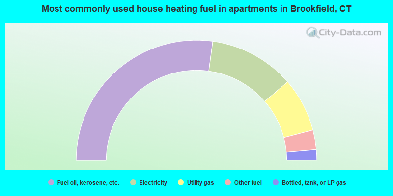
- 54.4%Fuel oil, kerosene, etc.
- 23.0%Electricity
- 14.6%Utility gas
- 5.3%Other fuel
- 2.8%Bottled, tank, or LP gas
Brookfield compared to Connecticut state average:
- Median household income above state average.
- Median house value above state average.
- Unemployed percentage significantly below state average.
- Black race population percentage significantly below state average.
- Hispanic race population percentage significantly below state average.
- Median age above state average.
- Foreign-born population percentage below state average.
- Renting percentage significantly below state average.
- Length of stay since moving in significantly above state average.
- Number of rooms per house significantly below state average.
- House age significantly below state average.
Brookfield on our top lists:
- #11 on the list of "Top 101 cities with largest percentage of females in occupations: advertising, marketing, promotions, public relations, and sales managers (population 5,000+)"
- #16 on the list of "Top 101 cities with largest percentage of males in industries: beverage and tobacco products (population 5,000+)"
- #21 on the list of "Top 101 cities with largest percentage of males in industries: miscellaneous durable goods merchant wholesalers (population 5,000+)"
- #23 on the list of "Top 101 cities with largest percentage of females in industries: publishing, and motion picture and sound recording industries (population 5,000+)"
- #28 on the list of "Top 101 cities with largest percentage of males in industries: paper and paper products merchant wholesalers (population 5,000+)"
- #35 on the list of "Top 101 cities with largest percentage of females in industries: chemicals (population 5,000+)"
- #39 on the list of "Top 101 cities with largest percentage of females in occupations: librarians, curators, and archivists (population 5,000+)"
- #40 on the list of "Top 101 cities with largest percentage of males in occupations: advertising, marketing, promotions, public relations, and sales managers (population 5,000+)"
- #44 on the list of "Top 101 cities with largest percentage of males in occupations: air transportation workers (population 5,000+)"
- #46 on the list of "Top 101 cities with largest percentage of males in industries: sewing, needlework, and piece goods stores (population 5,000+)"
- #49 on the list of "Top 101 cities with largest percentage of males in occupations: financial managers (population 5,000+)"
- #52 on the list of "Top 101 cities with largest percentage of males in occupations: other health diagnosing and treating practitioners and technical occupations (population 5,000+)"
- #52 on the list of "Top 101 cities with largest percentage of males in industries: chemicals (population 5,000+)"
- #57 on the list of "Top 101 cities with largest percentage of males in industries: publishing, and motion picture and sound recording industries (population 5,000+)"
- #59 on the list of "Top 101 cities with largest percentage of males in industries: sporting goods, camera, and hobby and toy stores (population 5,000+)"
- #60 on the list of "Top 101 cities with largest percentage of females in industries: professional and commercial equipment and supplies merchant wholesalers (population 5,000+)"
- #69 on the list of "Top 101 cities with largest percentage of females in industries: sporting goods, camera, and hobby and toy stores (population 5,000+)"
- #83 on the list of "Top 101 cities with largest percentage of males in industries: private households (population 5,000+)"
- #101 on the list of "Top 101 cities with the lowest number of robberies per 100,000 residents (population 5,000+)"
- #14 on the list of "Top 101 counties with the most Orthodox congregations"
- #18 on the list of "Top 101 counties with the best general health status score of residents (1-5), 3 years of data"
- #21 on the list of "Top 101 counties with the most Catholic congregations"
- #21 on the list of "Top 101 counties with the most Catholic adherents"
- #22 on the list of "Top 101 counties with the highest percentage of residents that visited a dentist within the past year"

|
|
Total of 665 patent applications in 2008-2024.