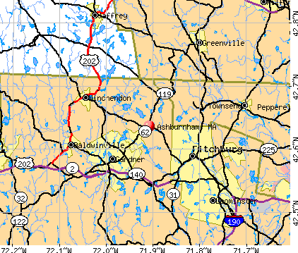
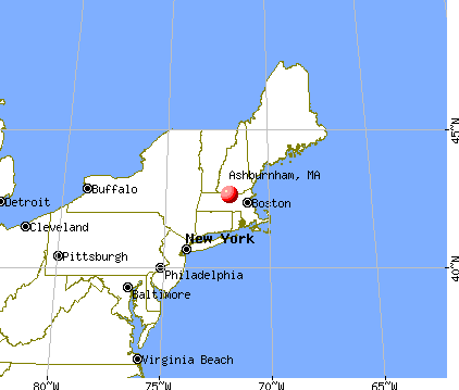
Ashburnham, Massachusetts
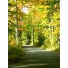
Ashburnham: Country Ashburnham Road in Autumn
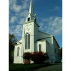
Ashburnham: Ashburnham Community Church

Ashburnham: The Old Grey Church making way for Cumberland Farms - Should we have let this come down?
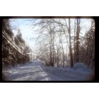
Ashburnham: Winter time some where in Ashburnham
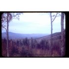
Ashburnham: On top of meeting house hill in Ashburnham

Ashburnham: sunset on lower naukeg lake
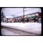
Ashburnham: Forgotten and long lost Main Street of Ashburnham in the Winter of 57 or 58

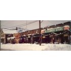
Ashburnham: Ashburnham in the Winter of 1948
Ashburnham: As I wish Ashburnham was the same I grew up to know in the 1970's not as it looks today!
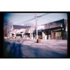
Ashburnham: Ashburnham Center in the 50's
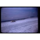
Ashburnham: Ice Racing on RT 119 in Ashburnham

Ashburnham: sunset in ashburnham
- add
your


Submit your own pictures of this town and show them to the world
- OSM Map
- General Map
- Google Map
- MSN Map
Population change since 2000: +9.6%
 |
| Males: 3,089 | |
| Females: 2,992 |
| Median resident age: | 40.8 years |
| Massachusetts median age: | 39.2 years |
Zip codes: 01430.
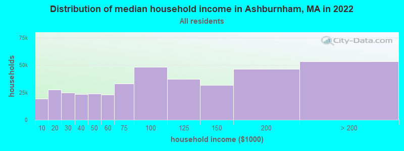
| Ashburnham: | $100,121 |
| MA: | $94,488 |
Estimated per capita income in 2022: $42,230 (it was $21,659 in 2000)
Ashburnham town income, earnings, and wages data
Estimated median house or condo value in 2022: $365,080 (it was $132,200 in 2000)
| Ashburnham: | $365,080 |
| MA: | $534,700 |
Mean prices in 2022: all housing units: $419,164; detached houses: $447,621; townhouses or other attached units: $343,592; in 2-unit structures: $323,295; in 3-to-4-unit structures: $332,295; in 5-or-more-unit structures: $232,758; mobile homes: $113,885
Detailed information about poverty and poor residents in Ashburnham, MA


- 5,71393.9%White alone
- 1552.5%Hispanic
- 791.3%Two or more races
- 711.2%Asian alone
- 530.9%Black alone
- 60.10%American Indian alone
- 20.03%Native Hawaiian and Other
Pacific Islander alone - 20.03%Other race alone
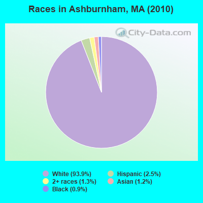
Races in Ashburnham detailed stats: ancestries, foreign born residents, place of birth
According to our research of Massachusetts and other state lists, there were 4 registered sex offenders living in Ashburnham, Massachusetts as of May 08, 2024.
The ratio of all residents to sex offenders in Ashburnham is 1,520 to 1.
The ratio of registered sex offenders to all residents in this city is near the state average.
Type |
2009 |
2010 |
2011 |
2012 |
2013 |
2014 |
2015 |
2016 |
2017 |
2018 |
2019 |
2020 |
2021 |
2022 |
|---|---|---|---|---|---|---|---|---|---|---|---|---|---|---|
| Murders (per 100,000) | 0 (0.0) | 0 (0.0) | 0 (0.0) | 0 (0.0) | 0 (0.0) | 0 (0.0) | 0 (0.0) | 0 (0.0) | 0 (0.0) | 0 (0.0) | 0 (0.0) | 0 (0.0) | 0 (0.0) | 0 (0.0) |
| Rapes (per 100,000) | 1 (16.5) | 2 (32.9) | 2 (32.7) | 0 (0.0) | 2 (32.4) | 2 (32.3) | 3 (48.3) | 2 (32.2) | 1 (16.0) | 1 (15.8) | 2 (31.6) | 1 (15.8) | 2 (31.1) | 1 (15.6) |
| Robberies (per 100,000) | 1 (16.5) | 0 (0.0) | 0 (0.0) | 1 (16.2) | 1 (16.2) | 2 (32.3) | 0 (0.0) | 0 (0.0) | 1 (16.0) | 0 (0.0) | 0 (0.0) | 0 (0.0) | 0 (0.0) | 0 (0.0) |
| Assaults (per 100,000) | 9 (148.7) | 11 (180.9) | 8 (130.8) | 9 (146.2) | 2 (32.4) | 6 (96.9) | 8 (128.9) | 8 (128.9) | 5 (79.9) | 5 (78.9) | 6 (94.8) | 7 (110.3) | 2 (31.1) | 10 (156.2) |
| Burglaries (per 100,000) | 16 (264.3) | 23 (378.2) | 19 (310.6) | 20 (324.9) | 20 (324.4) | 22 (355.4) | 16 (257.8) | 11 (177.2) | 9 (143.9) | 4 (63.1) | 7 (110.6) | 8 (126.1) | 6 (93.3) | 5 (78.1) |
| Thefts (per 100,000) | 39 (644.2) | 56 (920.9) | 48 (784.6) | 36 (584.9) | 44 (713.6) | 33 (533.1) | 48 (773.4) | 34 (547.9) | 40 (639.5) | 17 (268.4) | 18 (284.4) | 19 (299.5) | 16 (248.9) | 12 (187.4) |
| Auto thefts (per 100,000) | 3 (49.6) | 4 (65.8) | 2 (32.7) | 3 (48.7) | 1 (16.2) | 1 (16.2) | 1 (16.1) | 0 (0.0) | 1 (16.0) | 3 (47.4) | 3 (47.4) | 4 (63.1) | 1 (15.6) | 0 (0.0) |
| Arson (per 100,000) | 5 (82.6) | 1 (16.4) | 0 (0.0) | 1 (16.2) | 0 (0.0) | 0 (0.0) | 0 (0.0) | 1 (16.1) | 0 (0.0) | 0 (0.0) | 0 (0.0) | 0 (0.0) | 0 (0.0) | 0 (0.0) |
| City-Data.com crime index | 96.1 | 131.1 | 108.0 | 84.2 | 89.8 | 102.4 | 114.7 | 85.9 | 70.5 | 47.4 | 67.1 | 60.5 | 48.8 | 56.7 |
The City-Data.com crime index weighs serious crimes and violent crimes more heavily. Higher means more crime, U.S. average is 246.1. It adjusts for the number of visitors and daily workers commuting into cities.
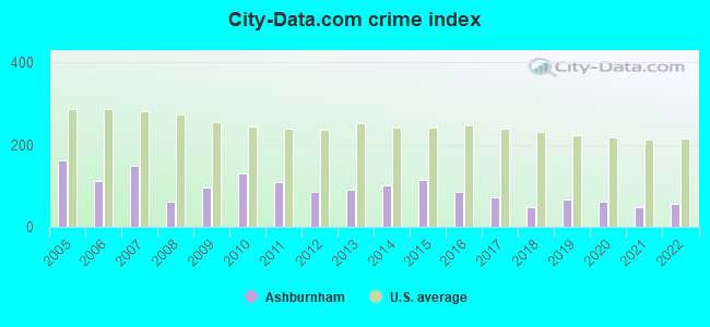
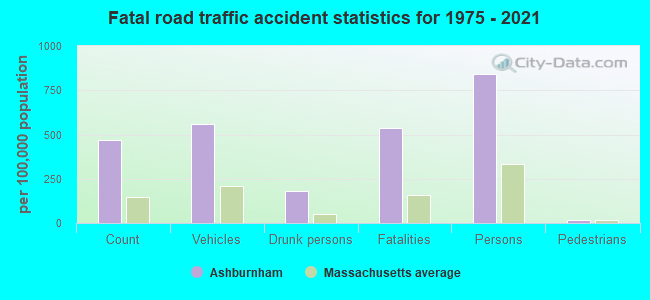
Crime rate in Ashburnham detailed stats: murders, rapes, robberies, assaults, burglaries, thefts, arson
Full-time law enforcement employees in 2021, including police officers: 17 (12 officers - 11 male; 1 female).
| Officers per 1,000 residents here: | 1.87 |
| Massachusetts average: | 2.53 |
 Recent articles from our blog. Our writers, many of them Ph.D. graduates or candidates, create easy-to-read articles on a wide variety of topics.


 | The worst winter in Massachusetts. Is the weather bothering you? (285 replies) |
| Man accused of killing wife with children inside their Massachusetts home (44 replies) |
| Depressed landlord - painful and rude tenant (72 replies) |
| Hillbilly Massachusetts (103 replies) |
| Coastal/Near Coastal Family Town (136 replies) |
| Seeking nature-oriented town with urban edge (99 replies) |
Latest news from Ashburnham, MA collected exclusively by city-data.com from local newspapers, TV, and radio stations
Ancestries: Irish (25.7%), French (21.2%), French Canadian (14.7%), English (13.0%), Italian (11.1%), German (5.9%).
Current Local Time: EST time zone
Incorporated in 1765
Elevation: 1028 feet
Land area: 38.7 square miles.
Population density: 157 people per square mile (very low).
235 residents are foreign born (2.0% North America, 1.4% Europe, 0.5% Latin America).
| This town: | 4.2% |
| Massachusetts: | 12.2% |
| Ashburnham town: | 1.5% ($1,934) |
| Massachusetts: | 1.3% ($2,336) |
Nearest city with pop. 50,000+: Nashua, NH  (23.8 miles , pop. 86,605).
Nearest city with pop. 200,000+: Boston, MA (48.9 miles , pop. 589,141).
Nearest city with pop. 1,000,000+: Bronx, NY (160.4 miles , pop. 1,332,650).
Nearest cities:
), Latitude: 42.66 N, Longitude: 71.93 W
Area code: 978
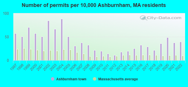
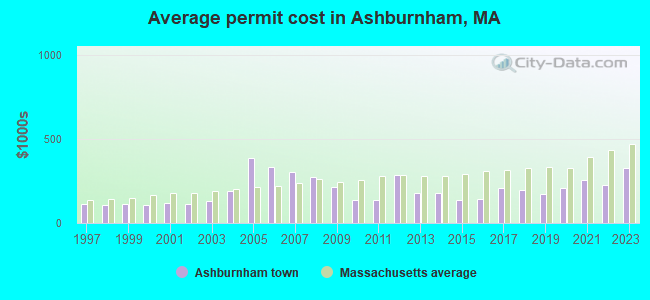
Single-family new house construction building permits:
- 2022: 22 buildings, average cost: $228,600
- 2021: 21 buildings, average cost: $253,600
- 2020: 27 buildings, average cost: $208,500
- 2019: 20 buildings, average cost: $174,300
- 2018: 12 buildings, average cost: $196,200
- 2017: 16 buildings, average cost: $209,500
- 2016: 18 buildings, average cost: $142,800
- 2015: 14 buildings, average cost: $137,000
- 2014: 11 buildings, average cost: $179,100
- 2013: 10 buildings, average cost: $177,700
- 2012: 6 buildings, average cost: $285,500
- 2011: 8 buildings, average cost: $135,400
- 2010: 11 buildings, average cost: $135,400
- 2009: 12 buildings, average cost: $216,000
- 2008: 18 buildings, average cost: $273,600
- 2007: 21 buildings, average cost: $304,300
- 2006: 17 buildings, average cost: $332,600
- 2005: 28 buildings, average cost: $384,300
- 2004: 49 buildings, average cost: $191,900
- 2003: 37 buildings, average cost: $129,100
- 2002: 47 buildings, average cost: $115,500
- 2001: 28 buildings, average cost: $118,300
- 2000: 32 buildings, average cost: $107,400
- 1999: 39 buildings, average cost: $111,600
- 1998: 28 buildings, average cost: $107,400
- 1997: 32 buildings, average cost: $111,800
| Here: | 3.1% |
| Massachusetts: | 3.5% |
- Educational services (14.6%)
- Health care (8.4%)
- Construction (7.5%)
- Public administration (6.2%)
- Professional, scientific, technical services (6.1%)
- Computer & electronic products (4.1%)
- Metal & metal products (3.8%)
- Construction (13.1%)
- Educational services (10.3%)
- Public administration (8.3%)
- Metal & metal products (5.6%)
- Computer & electronic products (5.5%)
- Professional, scientific, technical services (4.0%)
- Administrative & support & waste management services (3.8%)
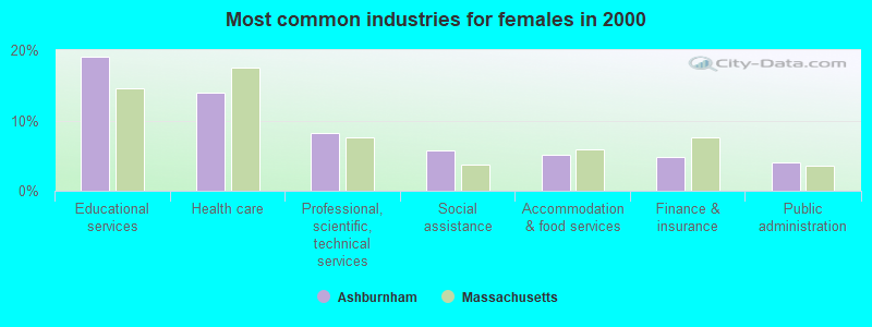
- Educational services (19.1%)
- Health care (13.9%)
- Professional, scientific, technical services (8.2%)
- Social assistance (5.7%)
- Accommodation & food services (5.1%)
- Finance & insurance (4.8%)
- Public administration (4.0%)
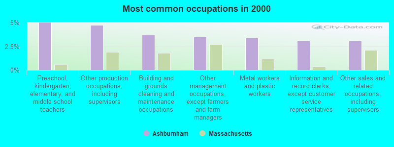
- Preschool, kindergarten, elementary, and middle school teachers (5.0%)
- Other production occupations, including supervisors (4.7%)
- Building and grounds cleaning and maintenance occupations (3.7%)
- Other management occupations, except farmers and farm managers (3.5%)
- Metal workers and plastic workers (3.4%)
- Information and record clerks, except customer service representatives (3.1%)
- Other sales and related occupations, including supervisors (3.1%)
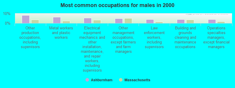
- Other production occupations, including supervisors (8.3%)
- Metal workers and plastic workers (6.3%)
- Electrical equipment mechanics and other installation, maintenance, and repair workers, including supervisors (5.6%)
- Other management occupations, except farmers and farm managers (4.8%)
- Law enforcement workers, including supervisors (4.0%)
- Building and grounds cleaning and maintenance occupations (4.0%)
- Operations specialties managers, except financial managers (3.9%)
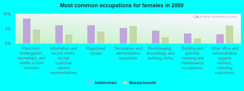
- Preschool, kindergarten, elementary, and middle school teachers (8.6%)
- Information and record clerks, except customer service representatives (6.3%)
- Registered nurses (6.2%)
- Secretaries and administrative assistants (5.4%)
- Bookkeeping, accounting, and auditing clerks (4.4%)
- Building and grounds cleaning and maintenance occupations (3.5%)
- Other office and administrative support workers, including supervisors (3.2%)
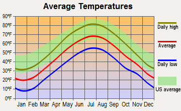
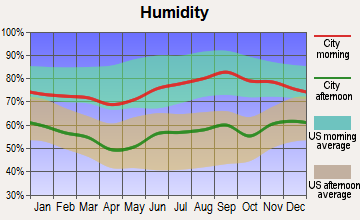
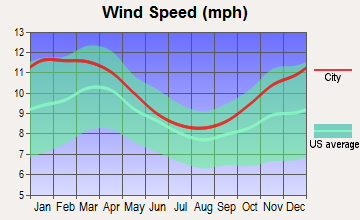
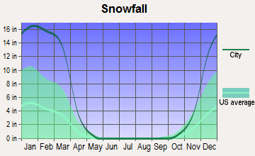
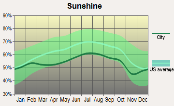
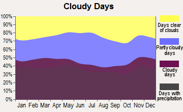
Average climate in Ashburnham, Massachusetts
Based on data reported by over 4,000 weather stations
(lower is better)
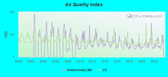
Air Quality Index (AQI) level in 2022 was 55.5. This is better than average.
| City: | 55.5 |
| U.S.: | 72.6 |
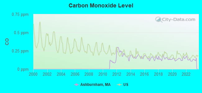
Carbon Monoxide (CO) [ppm] level in 2022 was 0.131. This is significantly better than average. Closest monitor was 14.3 miles away from the city center.
| City: | 0.131 |
| U.S.: | 0.251 |
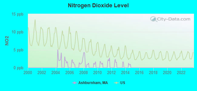
Nitrogen Dioxide (NO2) [ppb] level in 2008 was 2.01. This is significantly better than average. Closest monitor was 8.4 miles away from the city center.
| City: | 2.01 |
| U.S.: | 5.11 |
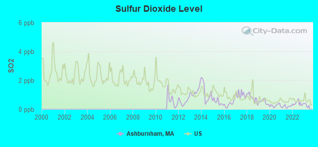
Sulfur Dioxide (SO2) [ppb] level in 2022 was 0.411. This is significantly better than average. Closest monitor was 6.3 miles away from the city center.
| City: | 0.411 |
| U.S.: | 1.515 |
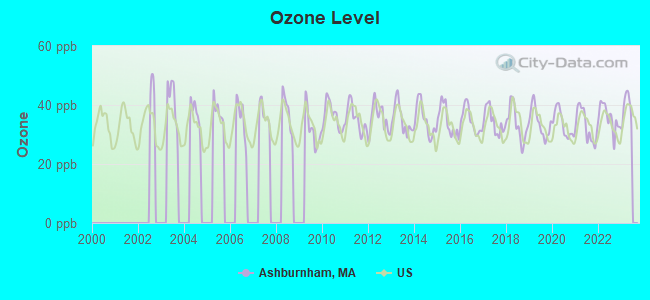
Ozone [ppb] level in 2022 was 35.6. This is about average. Closest monitor was 9.7 miles away from the city center.
| City: | 35.6 |
| U.S.: | 33.3 |

Particulate Matter (PM2.5) [µg/m3] level in 2022 was 4.18. This is significantly better than average. Closest monitor was 8.6 miles away from the city center.
| City: | 4.18 |
| U.S.: | 8.11 |
Tornado activity:
Ashburnham-area historical tornado activity is slightly above Massachusetts state average. It is 19% smaller than the overall U.S. average.
On 6/9/1953, a category F4 (max. wind speeds 207-260 mph) tornado 17.8 miles away from the Ashburnham town center killed 90 people and injured 1228 people and caused between $50,000,000 and $500,000,000 in damages.
On 6/22/1981, a category F3 (max. wind speeds 158-206 mph) tornado 7.7 miles away from the town center injured 3 people and caused between $5000 and $50,000 in damages.
Earthquake activity:
Ashburnham-area historical earthquake activity is significantly above Massachusetts state average. It is 71% smaller than the overall U.S. average.On 10/7/1983 at 10:18:46, a magnitude 5.3 (5.1 MB, 5.3 LG, 5.1 ML, Class: Moderate, Intensity: VI - VII) earthquake occurred 150.7 miles away from the city center
On 4/20/2002 at 10:50:47, a magnitude 5.3 (5.3 ML, Depth: 3.0 mi) earthquake occurred 155.7 miles away from Ashburnham center
On 4/20/2002 at 10:50:47, a magnitude 5.2 (5.2 MB, 4.2 MS, 5.2 MW, 5.0 MW) earthquake occurred 154.9 miles away from the city center
On 1/19/1982 at 00:14:42, a magnitude 4.7 (4.5 MB, 4.7 MD, 4.5 LG, Class: Light, Intensity: IV - V) earthquake occurred 60.6 miles away from the city center
On 10/16/2012 at 23:12:25, a magnitude 4.7 (4.7 ML, Depth: 10.0 mi) earthquake occurred 91.5 miles away from Ashburnham center
On 10/2/1994 at 11:27:22, a magnitude 3.7 (3.5 LG, 3.7 LG, Depth: 6.2 mi, Class: Light, Intensity: II - III) earthquake occurred 27.8 miles away from the city center
Magnitude types: regional Lg-wave magnitude (LG), body-wave magnitude (MB), duration magnitude (MD), local magnitude (ML), surface-wave magnitude (MS), moment magnitude (MW)
Natural disasters:
The number of natural disasters in Worcester County (27) is a lot greater than the US average (15).Major Disasters (Presidential) Declared: 15
Emergencies Declared: 12
Causes of natural disasters: Floods: 9, Storms: 8, Hurricanes: 6, Snowstorms: 5, Winter Storms: 4, Blizzards: 2, Snows: 2, Fire: 1, Heavy Rain: 1, Snowfall: 1, Tornado: 1, Wind: 1 (Note: some incidents may be assigned to more than one category).
Hospitals and medical centers in Ashburnham:
Other hospitals and medical centers near Ashburnham:
- GARDNER VNA (Home Health Center, about 5 miles away; GARDNER, MA)
- WACHUSETT MANOR NURSING HOME (Nursing Home, about 6 miles away; GARDNER, MA)
- HEYWOOD HOSPITAL Acute Care Hospitals (about 6 miles away; GARDNER, MA)
- GARDNER MANOR (Nursing Home, about 6 miles away; GARDNER, MA)
- GARDNER SKILLED NURSING CENTER (Nursing Home, about 6 miles away; GARDNER, MA)
- WACHUSETT MANOR (Nursing Home, about 7 miles away; GARDNER, MA)
- LEGEND REHABILITATION AND NURSING CENTER (Nursing Home, about 7 miles away; GARDNER, MA)
Colleges/universities with over 2000 students nearest to Ashburnham:
- Mount Wachusett Community College (about 6 miles; Gardner, MA; Full-time enrollment: 3,143)
- Fitchburg State University (about 9 miles; Fitchburg, MA; FT enrollment: 5,010)
- Franklin Pierce University (about 11 miles; Rindge, NH; FT enrollment: 2,139)
- Quinsigamond Community College (about 25 miles; Worcester, MA; FT enrollment: 5,877)
- Keene State College (about 26 miles; Keene, NH; FT enrollment: 5,098)
- Assumption College (about 26 miles; Worcester, MA; FT enrollment: 2,580)
- Worcester Polytechnic Institute (about 28 miles; Worcester, MA; FT enrollment: 3,930)
Public high school in Ashburnham:
- OAKMONT REGIONAL HIGH SCHOOL (Students: 738, Location: 9 OAKMONT DRIVE, Grades: 9-12)
Private high school in Ashburnham:
Public elementary/middle schools in Ashburnham:
- OVERLOOK MIDDLE SCHOOL (Students: 619, Location: 10 OAKMONT DRIVE, Grades: 6-8)
- BRIGGS ELEMENTARY (Students: 511, Location: 96 WILLIAMS RD, Grades: PK-5)
Points of interest:
Notable locations in Ashburnham: Camp Split Rock (A), Ashburnham Town Hall (B), Ashburnham Fire Department South Station (C), Ashburnham Fire Department Headquarters (D), Stevens Memorial Library (E). Display/hide their locations on the map
Churches in Ashburnham include: Saint Annes Church (A), Peoples Congregational Church (B), Ashburnham Community Church (C). Display/hide their locations on the map
Cemeteries: Saint Dennis Cemetery (1), The New Cemetery (2). Display/hide their locations on the map
Lakes and reservoirs: Watatic Pond (A), Ward Pond (B), Wallace Pond (C), Lower Naukeag Lake (D), Jeffs Pond (E), Cheshire Pond (F), Whitney Pond (G), Lincoln Pond (H). Display/hide their locations on the map
Streams, rivers, and creeks: Laws Brook (A), Bear Meadow Brook (B), Bluefield Brook (C), Brown Brook (D), Estees Brook (E), Whitemans Brook (F). Display/hide their locations on the map
Parks in Ashburnham include: Bickford Field (1), Watatic Mountain State Wildlife Area (2). Display/hide their locations on the map
Birthplace of: Harrison Carroll Hobart - Politician.
Drinking water stations with addresses in Ashburnham and their reported violations in the past:
ASHBURNHAM WATER DEPARTMENT (Population served: 3,670, Purch surface water):Past monitoring violations:
- Monitoring and Reporting (DBP) - Between APR-2014 and JUN-2014, Contaminant: Chlorine. Follow-up actions: St AO (w/o penalty) issued (SEP-10-2014)
- Monitoring and Reporting (DBP) - Between JUL-2012 and SEP-2012, Contaminant: Chlorine. Follow-up actions: St AO (w/o penalty) issued (DEC-05-2012), St Compliance achieved (JUL-01-2013)
- Monitoring and Reporting (DBP) - Between APR-2011 and JUN-2011, Contaminant: Chlorine. Follow-up actions: St AO (w/o penalty) issued (SEP-09-2011), St Compliance achieved (JAN-31-2014)
- Monitoring and Reporting (DBP) - Between JAN-2011 and MAR-2011, Contaminant: Chlorine. Follow-up actions: St AO (w/o penalty) issued (JUN-07-2011), St Compliance achieved (JAN-31-2012)
- Monitoring and Reporting (DBP) - Between OCT-2010 and DEC-2010, Contaminant: Chlorine. Follow-up actions: St AO (w/o penalty) issued (FEB-17-2011), St Compliance achieved (FEB-17-2011)
- One minor monitoring violation
- One regular monitoring violation
- 6 other older monitoring violations
| This town: | 2.8 people |
| Massachusetts: | 2.5 people |
| This town: | 77.3% |
| Whole state: | 63.0% |
| This town: | 8.3% |
| Whole state: | 7.0% |
Likely homosexual households (counted as self-reported same-sex unmarried-partner households)
- Lesbian couples: 0.7% of all households
- Gay men: 0.4% of all households
| This town: | 6.4% |
| Whole state: | 9.3% |
| This town: | 2.4% |
| Whole state: | 4.4% |
60 people in college/university student housing in 2010
17 people in nursing homes in 2000
Banks with branches in Ashburnham (2011 data):
- Athol Savings Bank: Ashburnham Branch at 52 Main Street, branch established on 1972/09/15. Info updated 2008/03/03: Bank assets: $327.4 mil, Deposits: $277.2 mil, headquarters in Athol, MA, positive income, Mortgage Lending Specialization, 8 total offices
For population 15 years and over in Ashburnham:
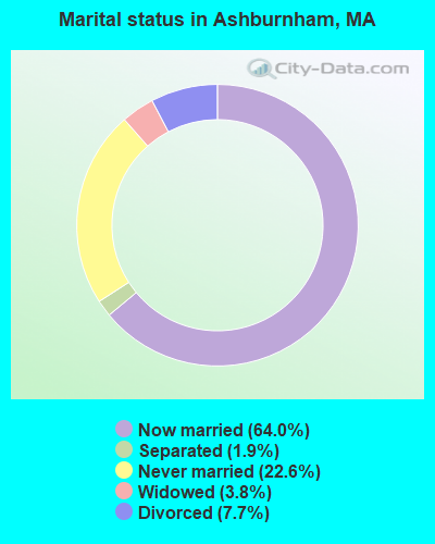
- Never married: 22.6%
- Now married: 64.0%
- Separated: 1.9%
- Widowed: 3.8%
- Divorced: 7.7%
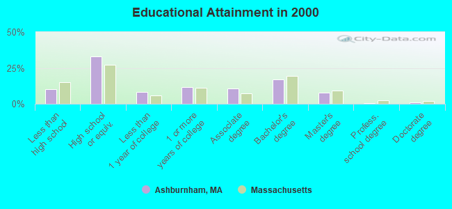
For population 25 years and over in Ashburnham:
- High school or higher: 90.0%
- Bachelor's degree or higher: 26.1%
- Graduate or professional degree: 9.0%
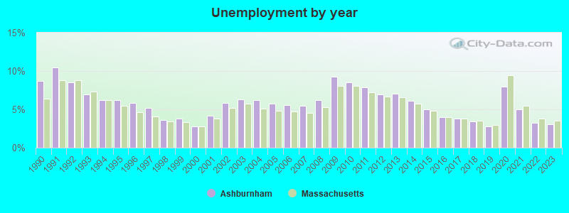
- Unemployed: 3.2%
- Mean travel time to work (commute): 31.4 minutes
| Here: | 10.0 |
| Massachusetts average: | 13.1 |


Graphs represent county-level data. Detailed 2008 Election Results
Religion statistics for Ashburnham, MA (based on Worcester County data)


| Religion | Adherents | Congregations |
|---|---|---|
| Catholic | 306,925 | 118 |
| Mainline Protestant | 43,326 | 171 |
| Evangelical Protestant | 37,511 | 203 |
| Other | 18,931 | 69 |
| Orthodox | 7,935 | 15 |
| Black Protestant | 497 | 6 |
| None | 383,427 | - |
Food Environment Statistics:
| Worcester County: | 1.73 / 10,000 pop. |
| Massachusetts: | 1.98 / 10,000 pop. |
| This county: | 0.05 / 10,000 pop. |
| State: | 0.05 / 10,000 pop. |
| Worcester County: | 1.79 / 10,000 pop. |
| Massachusetts: | 2.22 / 10,000 pop. |
| Worcester County: | 2.22 / 10,000 pop. |
| State: | 1.77 / 10,000 pop. |
| Here: | 7.27 / 10,000 pop. |
| State: | 8.76 / 10,000 pop. |
| This county: | 8.0% |
| Massachusetts: | 8.1% |
| Worcester County: | 24.0% |
| Massachusetts: | 22.5% |
| This county: | 16.6% |
| State: | 16.5% |
4.71% of this county's 2021 resident taxpayers lived in other counties in 2020 ($76,229 average adjusted gross income)
| Here: | 4.71% |
| Massachusetts average: | 6.35% |
0.02% of residents moved from foreign countries ($100 average AGI)
Worcester County: 0.02% Massachusetts average: 0.01%
Top counties from which taxpayers relocated into this county between 2020 and 2021:
| from Middlesex County, MA | |
| from Norfolk County, MA | |
| from Suffolk County, MA |
4.84% of this county's 2020 resident taxpayers moved to other counties in 2021 ($87,252 average adjusted gross income)
| Here: | 4.84% |
| Massachusetts average: | 7.18% |
0.03% of residents moved to foreign countries ($199 average AGI)
Worcester County: 0.03% Massachusetts average: 0.02%
Top counties to which taxpayers relocated from this county between 2020 and 2021:
| to Middlesex County, MA | |
| to Norfolk County, MA | |
| to Suffolk County, MA |
Businesses in Ashburnham, MA
- Dunkin Donuts: 1
- True Value: 1
Strongest AM radio stations in Ashburnham:
- WEIM (1280 AM; 5 kW; FITCHBURG, MA; Owner: LIVEAIR COMMUNICATIONS, INC.)
- WCRN (830 AM; 50 kW; WORCESTER, MA; Owner: CARTER BROADCASTING CORPORATION)
- WFGL (960 AM; 2 kW; FITCHBURG, MA; Owner: CSN INTERNATIONAL)
- WRKO (680 AM; 50 kW; BOSTON, MA; Owner: ENTERCOM BOSTON LICENSE, LLC)
- WVNE (760 AM; daytime; 25 kW; LEICESTER, MA; Owner: BLOUNT MASSCOM, INC.)
- WKOX (1200 AM; 50 kW; FRAMINGHAM, MA; Owner: CAPSTAR TX LIMITED PARTNERSHIP)
- WEEI (850 AM; 50 kW; BOSTON, MA; Owner: ENTERCOM BOSTON LICENSE, LLC)
- WBIX (1060 AM; 40 kW; NATICK, MA; Owner: LANGER BROADCASTING CORPORATION)
- WGAW (1340 AM; 1 kW; GARDNER, MA; Owner: ANASTOS MEDIA GROUP, INC.)
- WNNZ (640 AM; 50 kW; WESTFIELD, MA; Owner: CLEAR CHANNEL BROADCASTING LICENSES, INC.)
- WWZN (1510 AM; 50 kW; BOSTON, MA; Owner: ROSE CITY RADIO CORPORATION)
- WALE (990 AM; 50 kW; GREENVILLE, RI; Owner: NORTH AMERICAN BROADCASTING CO., INC.)
- WAMG (890 AM; 25 kW; DEDHAM, MA; Owner: MEGA COMMUNICATIONS OF DEDHAM LICENSEE, LLC)
Strongest FM radio stations in Ashburnham:
- WFEX (92.1 FM; PETERBOROUGH, NH; Owner: FNX BROADCASTING OF NEW HAMPSHIRE LLC)
- WINQ (97.7 FM; WINCHENDON, MA; Owner: SAGA COMMUNICATIONS OF NEW ENGLAND, LLC)
- WXLO (104.5 FM; FITCHBURG, MA; Owner: CITADEL BROADCASTING COMPANY)
- WAAF (107.3 FM; WORCESTER, MA; Owner: ENTERCOM BOSTON LICENSE, LLC)
- WAHL (99.9 FM; ATHOL, MA; Owner: CITADEL BROADCASTING COMPANY)
- WSRS (96.1 FM; WORCESTER, MA; Owner: CAPSTAR TX LIMITED PARTNERSHIP)
- WGIR-FM (101.1 FM; MANCHESTER, NH; Owner: CAPSTAR TX LIMITED PARTNERSHIP)
- WQLL (96.5 FM; BEDFORD, NH; Owner: SAGA COMMUNICATIONS OF NEW ENGLAND, LLC)
- WLMW (90.7 FM; MANCHESTER, NH; Owner: KNOWLEDGE FOR LIFE)
- WHDQ (106.1 FM; CLAREMONT, NH; Owner: GREAT NORTHERN RADIO, L.L.C.)
- WZID (95.7 FM; MANCHESTER, NH; Owner: SAGA COMMUNICATIONS OF NEW ENGLAND, LLC)
- WFCR (88.5 FM; AMHERST, MA; Owner: UNIVERSITY OF MASSACHUSETTS)
- WVPR (89.5 FM; WINDSOR, VT; Owner: VERMONT PUBLIC RADIO)
- WKNE (103.7 FM; KEENE, NH; Owner: SAGA COMMUNICATIONS OF NEW ENGLAND, LLC)
- WEQX (102.7 FM; MANCHESTER, VT; Owner: NORTHSHIRE COMMUNICATIONS, INC.)
- WEVN (90.7 FM; KEENE, NH; Owner: NEW HAMPSHIRE PUBLIC RADIO, INC.)
- WYRY (104.9 FM; HINSDALE, NH; Owner: TRI-VALLEY BROADCASTING CORPORATION)
- WOQL (98.7 FM; WINCHESTER, NH; Owner: SAGA COMMUNICATIONS OF NEW HAMPSHIRE, LLC)
- WBMX (98.5 FM; BOSTON, MA; Owner: INFINITY RADIO OPERATIONS INC.)
- WJMN (94.5 FM; BOSTON, MA; Owner: AMFM RADIO LICENSES, L.L.C.)
TV broadcast stations around Ashburnham:
- WUNI (Channel 27; WORCESTER, MA; Owner: ENTRAVISION HOLDINGS, LLC)
- WUTF (Channel 66; MARLBOROUGH, MA; Owner: TELEFUTURA BOSTON LLC)
- WCVB-TV (Channel 5; BOSTON, MA; Owner: WCVB HEARST-ARGYLE TV, INC.)
- WGBH-TV (Channel 2; BOSTON, MA; Owner: WGBH EDUCATIONAL FOUNDATION)
- WYDN (Channel 48; WORCESTER, MA; Owner: EDUCATIONAL PUBLIC TV CORPORATION)
- WHDH-TV (Channel 7; BOSTON, MA; Owner: WHDH-TV)
- WMFP (Channel 62; LAWRENCE, MA; Owner: WSAH LICENSE, INC.)
- WBZ-TV (Channel 4; BOSTON, MA; Owner: VIACOM INC.)
- WGBX-TV (Channel 44; BOSTON, MA; Owner: WGBH EDUCATIONAL FOUNDATION)
- WSBK-TV (Channel 38; BOSTON, MA; Owner: VIACOM INC.)
- WLVI-TV (Channel 56; CAMBRIDGE, MA; Owner: WLVI, INC.)
- WFXT (Channel 25; BOSTON, MA; Owner: FOX TELEVISION STATIONS INC.)
- WFXZ-CA (Channel 24; BOSTON, MA; Owner: BOSTON BROADCASTING CORP.)
- WNDS (Channel 50; DERRY, NH; Owner: CTV OF DERRY, INC)
- National Bridge Inventory (NBI) Statistics
- 5Number of bridges
- 13ft / 3.7mTotal length
- $2,216,000Total costs
- 3,557Total average daily traffic
- 66Total average daily truck traffic
- 5,338Total future (year 2031) average daily traffic
FCC Registered Cell Phone Towers:
1 (See the full list of FCC Registered Cell Phone Towers in Ashburnham)FCC Registered Antenna Towers:
17 (See the full list of FCC Registered Antenna Towers)FCC Registered Broadcast Land Mobile Towers:
10 (See the full list of FCC Registered Broadcast Land Mobile Towers in Ashburnham, MA)FCC Registered Microwave Towers:
3- 9004, 87 Byfield Rd (Lat: 42.674167 Lon: -71.867778), Type: Tower, Structure height: 68.6 m, Overall height: 74.1 m, Call Sign: WPXE383,
Assigned Frequencies: 17745.0 MHz, 17765.0 MHz, Grant Date: 03/17/2003, Expiration Date: 03/17/2013, Cancellation Date: 12/27/2007, Certifier: Carol L Tacker, Registrant: Cingular Wireless LLC, 5601 Legacy Drive Ms A-3, Plano, TX 75024, Phone: (469) 229-7506, Fax: (469) 229-7295, Email:
- Asburnham Rd Tower, 207 Asburnham Rd (Lat: 42.583722 Lon: -71.887833), Type: Ltower, Structure height: 57.9 m, Overall height: 59.4 m, Call Sign: WSAR751,
Assigned Frequencies: 17915.0 MHz, Grant Date: 02/07/2024, Expiration Date: 02/07/2034, Certifier: Salvatore J Albert Jr, Registrant: Micronet Communications, Inc., 812 Lexington Dr, Plano, TX 75075, Phone: (972) 422-7200, Email:
- Overlook Middle Scho, 10 Oakmont Drive (Lat: 42.602861 Lon: -71.926167), Type: Building, Structure height: 12.2 m, Overall height: 18.3 m, Call Sign: WSAR752,
Assigned Frequencies: 19475.0 MHz, Grant Date: 02/07/2024, Expiration Date: 02/07/2034, Certifier: Salvatore J Albert Jr, Registrant: Micronet Communications, Inc., 812 Lexington Dr, Plano, TX 75075, Phone: (972) 422-7200, Email:
FCC Registered Amateur Radio Licenses:
51 (See the full list of FCC Registered Amateur Radio Licenses in Ashburnham)FAA Registered Aircraft:
1- Aircraft: CESSNA 172M (Category: Land, Seats: 4, Weight: Up to 12,499 Pounds, Speed: 108 mph), Engine: LYCOMING 0-320 SERIES (180 HP) (4 Cycle)
N-Number: 12676, N12676, N-12676, Serial Number: 17262167, Year manufactured: 1973, Certificate Issue Date: 08/18/2016
Registrant (Co-Owned): Victor A Berry, 101 Kelton Rd, Ashburnham, MA 01430, Other Owners: Paul E Coccari, Gerard P Palace
2002 - 2018 National Fire Incident Reporting System (NFIRS) incidents
- Fire incident types reported to NFIRS in Ashburnham, MA
- 17052.8%Structure Fires
- 11134.5%Outside Fires
- 288.7%Mobile Property/Vehicle Fires
- 134.0%Other
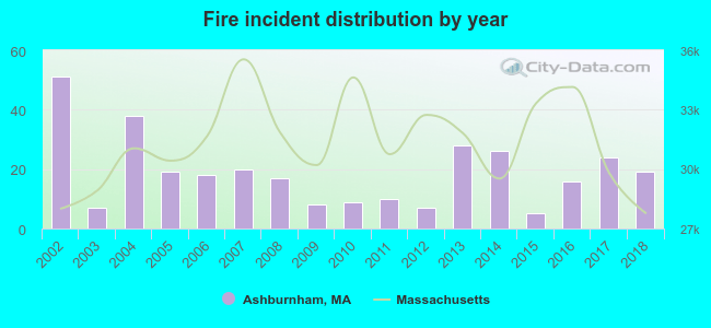 Based on the data from the years 2002 - 2018 the average number of fire incidents per year is 19. The highest number of fires - 51 took place in 2002, and the least - 5 in 2015. The data has a decreasing trend.
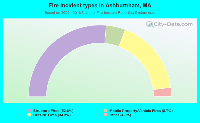 When looking into fire subcategories, the most incidents belonged to: Structure Fires (52.8%), and Outside Fires (34.5%).
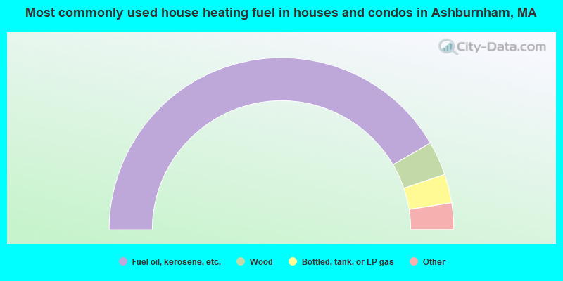
- 83.2%Fuel oil, kerosene, etc.
- 6.4%Wood
- 5.4%Bottled, tank, or LP gas
- 2.3%Utility gas
- 2.2%Electricity
- 0.2%Coal or coke
- 0.2%Other fuel
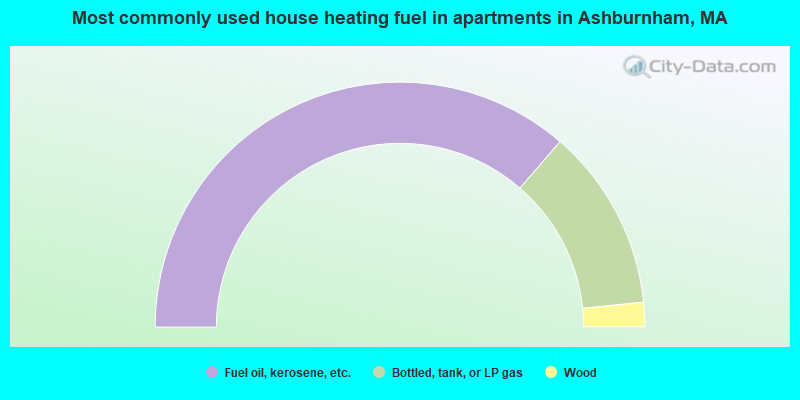
- 72.7%Fuel oil, kerosene, etc.
- 24.1%Bottled, tank, or LP gas
- 3.2%Wood
Ashburnham compared to Massachusetts state average:
- Unemployed percentage significantly below state average.
- Black race population percentage significantly below state average.
- Hispanic race population percentage significantly below state average.
- Foreign-born population percentage significantly below state average.
- Renting percentage significantly below state average.
- Length of stay since moving in significantly above state average.
- Number of rooms per house significantly below state average.
- House age significantly below state average.
Ashburnham on our top lists:
- #7 on the list of "Top 101 cities with largest percentage of males in occupations: secondary school teachers (population 5,000+)"
- #9 on the list of "Top 101 cities with largest percentage of females in industries: fuel dealers (population 5,000+)"
- #18 on the list of "Top 101 cities with largest percentage of males in industries: music stores (population 5,000+)"
- #21 on the list of "Top 101 cities with largest percentage of males in occupations: operations specialties managers except financial managers (population 5,000+)"
- #23 on the list of "Top 101 cities with largest percentage of males in industries: fuel dealers (population 5,000+)"
- #33 on the list of "Top 101 cities with largest percentage of females in occupations: pipelayers, plumbers, pipefitters, and steamfitters (population 5,000+)"
- #40 on the list of "Top 101 cities with largest percentage of males in industries: plastics and rubber products (population 5,000+)"
- #45 on the list of "Top 101 cities with largest percentage of females in industries: religious, grantmaking, civic, professional, and similar organizations (population 5,000+)"
- #60 on the list of "Top 101 cities with largest percentage of females in occupations: information and record clerks except customer service representatives (population 5,000+)"
- #62 on the list of "Top 101 cities with largest percentage of males in industries: miscellaneous durable goods merchant wholesalers (population 5,000+)"
- #63 on the list of "Top 101 cities with largest percentage of males in industries: paper (population 5,000+)"
- #68 on the list of "Top 101 cities with largest percentage of males in occupations: motor vehicle operators except bus and truck drivers (population 5,000+)"
- #71 on the list of "Top 101 cities with largest percentage of females in occupations: secondary school teachers (population 5,000+)"
- #76 on the list of "Top 101 cities with largest percentage of males in industries: metals and minerals, except petroleum, merchant wholesalers (population 5,000+)"
- #91 on the list of "Top 101 cities with largest percentage of females in industries: machinery (population 5,000+)"
- #91 on the list of "Top 101 cities with largest percentage of females in industries: sewing, needlework, and piece goods stores (population 5,000+)"
- #99 on the list of "Top 101 cities with largest percentage of females in industries: paper and paper products merchant wholesalers (population 5,000+)"
- #4 on the list of "Top 101 counties with the highest carbon monoxide air pollution readings in 2012 (ppm)"
- #5 on the list of "Top 101 counties with the most Catholic congregations"
- #12 on the list of "Top 101 counties with the highest surface withdrawal of fresh water for public supply"
- #16 on the list of "Top 101 counties with the highest total withdrawal of fresh water for public supply"
- #23 on the list of "Top 101 counties with the highest Sulfur Oxides Annual air pollution readings in 2012 (µg/m3)"

|
|
Total of 38 patent applications in 2008-2024.