Bridge Statistics for Zebulon, North Carolina (NC)
Condition, Traffic, Stress, Structural Evaluation, Project Costs
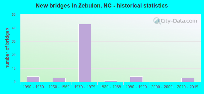
- New bridges - historical statistics
- 41950-1959
- 31960-1969
- 431970-1979
- 11980-1989
- 41990-1999
- 32010-2019


- Bridge Condition - Deck
- 3.8%Very good
- 19.2%Good
- 61.5%Satisfactory
- 11.5%Fair
- 3.8%Poor

- Bridge Condition - Superstructure
- 3.8%Very good
- 50.0%Good
- 38.5%Satisfactory
- 7.7%Fair

- Bridge Condition - Substructure
- 3.8%Very good
- 15.4%Good
- 61.5%Satisfactory
- 19.2%Fair

- Bridge Condition - Channel
- 4.2%Very good
- 54.2%Good
- 33.3%Satisfactory
- 8.3%Fair

- Bridge Condition - Culverts
- 11.1%Good
- 55.6%Satisfactory
- 22.2%Fair
- 11.1%Poor
Find on map >> Show street view
Structure Number: 1830208, Location: 0.7 MI. N. JCT. SR2406 (Lat: 35.836469, Lng: -78.301842), Route carried "under" structure: US 64, Year Built: 1973, Structure Length: 0. m, Average Daily Traffic: 15,250 (year 2018), Truck Traffic: 12%, Features Intersected: SR2320
Minimum Vertical Clearance: 5.73m (18.80ft), Kilometerpoint: 0.000, Lanes on structure: 2, Lanes under structure: 2, Material/Design: Steel continuous, Design/Construction: Stringer/Multi-beam, Length of Maximum Span: 41.4m (135.8ft)
Find on map >> Show street view
Structure Number: 1830208, Location: 0.7 MI. N. JCT. SR2406 (Lat: 35.836469, Lng: -78.301842), Route carried "under" structure: Ramp US 64, Year Built: 1973, Structure Length: 0. m, Average Daily Traffic: 10,166 (year 2018), Truck Traffic: 12%, Features Intersected: SR2320
Minimum Vertical Clearance: 5.36m (17.59ft), Kilometerpoint: 0.000, Lanes on structure: 2, Lanes under structure: 1, Material/Design: Steel continuous, Design/Construction: Stringer/Multi-beam, Length of Maximum Span: 41.4m (135.8ft)
Find on map >> Show street view
Structure Number: 1830212, Location: 0.1 MI. N. OF JCT. SR2341 (Lat: 35.850825, Lng: -78.285847), Route carried "under" structure: US 64, Year Built: 1973, Structure Length: 0. m, Average Daily Traffic: 14,500 (year 2017), Truck Traffic: 12%, Features Intersected: SR2337
Minimum Vertical Clearance: 5.33m (17.49ft), Kilometerpoint: 0.000, Lanes on structure: 2, Lanes under structure: 2, Material/Design: Steel continuous, Design/Construction: Stringer/Multi-beam, Length of Maximum Span: 35.3m (115.8ft)
Find on map >> Show street view
Structure Number: 1830212, Location: 0.1 MI. N. OF JCT. SR2341 (Lat: 35.850825, Lng: -78.285847), Route carried "under" structure: US 64, Year Built: 1973, Structure Length: 0. m, Average Daily Traffic: 14,500 (year 2017), Truck Traffic: 12%, Features Intersected: SR2337
Minimum Vertical Clearance: 5.10m (16.73ft), Kilometerpoint: 0.000, Lanes on structure: 2, Lanes under structure: 2, Material/Design: Steel continuous, Design/Construction: Stringer/Multi-beam, Length of Maximum Span: 35.3m (115.8ft)