Bridge Statistics for Wichita Falls, Texas (TX)
Condition, Traffic, Stress, Structural Evaluation, Project Costs
- National Bridge Inventory (NBI) Statistics
- 364Number of bridges
- 6,401ft / 1,951mTotal length
- $12,304,000Total costs
- 3,596,831Total average daily traffic
- 427,747Total average daily truck traffic
- National Bridge Inventory (NBI) Registered Bridges for Wichita Falls
- No street view available for this location
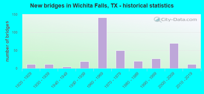
- New bridges - historical statistics
- 111920-1929
- 111930-1939
- 41940-1949
- 191950-1959
- 1411960-1969
- 501970-1979
- 201980-1989
- 271990-1999
- 702000-2009
- 112010-2019

- Reconstructed bridges - Historical Statistics
- 11930-1939
- 51940-1949
- 21950-1959
- 71960-1969
- 21970-1979
- 101980-1989
- 121990-1999
- 42000-2009
- 12010-2019


- Bridge Condition - Deck
- 2.7%Very good
- 71.4%Good
- 22.4%Satisfactory
- 2.7%Fair
- 0.7%Poor

- Bridge Condition - Superstructure
- 12.2%Very good
- 57.1%Good
- 27.2%Satisfactory
- 2.7%Fair
- 0.7%Poor

- Bridge Condition - Substructure
- 0.7%Very good
- 63.3%Good
- 33.3%Satisfactory
- 2.7%Fair

- Bridge Condition - Channel
- 3.5%Very good
- 45.1%Good
- 41.7%Satisfactory
- 9.7%Fair

- Bridge Condition - Culverts
- 1.8%Very good
- 37.5%Good
- 51.8%Satisfactory
- 8.9%Fair
Find on map >> Show street view
Structure Number: 32430B04131013, Location: 0.45 MI S OF B 287J (Lat: 33.929567, Lng: -98.575264), Route carried "on" structure: City street , Year Built: 1940, Status: Open, Structure Length: 0.79m (2.59ft), Average Daily Traffic: 2,070 (year 2010), Average Future Daily Traffic: 4,000 (year 2030), Features Intersected: POND CREEK, Facility Carried by Structure: PAMARIV ROAD
Minimum Vertical Clearance: 30+ m (98+ ft), Kilometerpoint: 1.722, Lanes on structure: 2, Owner: City or Municipal Highway Agency, Approaching Roadway Width: 6.1m (20.0ft), Material/Design: Concrete, Design/Construction: Culvert, Number Of Spans In Main Unit: 3, Length of Maximum Span: 2.4m (7.9ft), Curb-To-Curb Width: 7.3m (24.0ft), Out-to-Out Width: 8.2m (26.9ft)
Condition: Channel: Satisfactory, Culverts: Good, Operating Rating: 32.7 metric tons, Method Used To Determine Operating Rating: Field evaluation and documented engineering judgment, Inventory Rating: 24.5 metric tons, Method Used To Determine Inventory Rating: Field evaluation and documented engineering judgment, Structural Evaluation: Equal to present minimum criteria, Deck Geometry: High priority of replacement, Waterway Adequacy: Equal to present minimum criteria, Approach Roadway Alignment: Equal to present desirable criteria, Length Of Structure Improvement: 0.79m (2.59ft), Designated Inspection Frequency: Every 24 months, Inspection Date: October 2020, Bridge Improvement Cost: $52,000, Roadway Improvement Cost: $21,000, Total Project Cost: $73,000, Deck Structure Type: Concrete Cast-file-Place, Wearing Surface/Protective System: Wearing Surface: Bituminous
Find on map >> Show street view
Structure Number: 32430B04700003, Location: 0.45 MI N OF B 287J (Lat: 33.933925, Lng: -98.510233), Route carried "on" structure: City street , Year Built: 1942, Status: Open, Structure Length: 1.65m (5.41ft), Average Daily Traffic: 1,745 (year 2020), Average Future Daily Traffic: 8,000 (year 2030), Features Intersected: PLUM CREEK, Facility Carried by Structure: SHEPPARD ACCESS RD
Minimum Vertical Clearance: 30+ m (98+ ft), Kilometerpoint: 2.375, Lanes on structure: 4, Owner: City or Municipal Highway Agency, Approaching Roadway Width: 13.7m (44.9ft), Material/Design: Concrete, Design/Construction: Culvert, Number Of Spans In Main Unit: 5, Length of Maximum Span: 3.0m (9.8ft), Curb-To-Curb Width: 29.1m (95.5ft), Out-to-Out Width: 29.7m (97.4ft)
Condition: Channel: Good, Culverts: Satisfactory, Operating Rating: 32.7 metric tons, Method Used To Determine Operating Rating: Field evaluation and documented engineering judgment, Inventory Rating: 24.5 metric tons, Method Used To Determine Inventory Rating: Field evaluation and documented engineering judgment, Structural Evaluation: Equal to present minimum criteria, Deck Geometry: Superior to present desirable criteria, Waterway Adequacy: Equal to present minimum criteria, Approach Roadway Alignment: Equal to present desirable criteria, Length Of Structure Improvement: 1.65m (5.41ft), Designated Inspection Frequency: Every 24 months, Inspection Date: October 2020, Bridge Improvement Cost: $146,000, Roadway Improvement Cost: $218,000, Total Project Cost: $364,000, Deck Structure Type: Concrete Cast-file-Place, Wearing Surface/Protective System: Wearing Surface: Monolithic Concrete
Find on map >> Show street view
Structure Number: 32430B04700004, Location: 0.80 MI N OF B 287J (Lat: 33.939597, Lng: -98.511700), Route carried "on" structure: City street , Year Built: 1944, Status: Open, Structure Length: 0.76m (2.49ft), Average Daily Traffic: 1,816 (year 2020), Average Future Daily Traffic: 7,000 (year 2030), Features Intersected: N IRRIGATION CANAL, Facility Carried by Structure: SHEPPARD ACCESS RD
Minimum Vertical Clearance: 30+ m (98+ ft), Kilometerpoint: 3.034, Lanes on structure: 4, Owner: City or Municipal Highway Agency, Approaching Roadway Width: 13.7m (44.9ft), Skew: 24 degrees, Material/Design: Concrete, Design/Construction: Culvert, Number Of Spans In Main Unit: 3, Length of Maximum Span: 1.5m (4.9ft), Curb-To-Curb Width: 13.7m (44.9ft), Out-to-Out Width: 35.1m (115.2ft)
Condition: Channel: Good, Culverts: Satisfactory, Operating Rating: 32.7 metric tons, Method Used To Determine Operating Rating: Field evaluation and documented engineering judgment, Inventory Rating: 24.5 metric tons, Method Used To Determine Inventory Rating: Field evaluation and documented engineering judgment, Structural Evaluation: Equal to present minimum criteria, Deck Geometry: High priority of replacement, Waterway Adequacy: Equal to present minimum criteria, Approach Roadway Alignment: Equal to present desirable criteria, Length Of Structure Improvement: 0.70m (2.30ft), Designated Inspection Frequency: Every 24 months, Inspection Date: October 2020, Bridge Improvement Cost: $2,000, Roadway Improvement Cost: $1,000, Total Project Cost: $3,000, Deck Structure Type: Concrete Cast-file-Place, Wearing Surface/Protective System: Wearing Surface: Monolithic Concrete
Find on map >> Show street view
Structure Number: 32430B04870001, Location: 0.6 MI N OF B 287J (Lat: 33.937831, Lng: -98.525033), Route carried "on" structure: City street , Year Built: 1989, Status: Open, Structure Length: 0.88m (2.89ft), Average Daily Traffic: 1,150 (year 2020), Average Future Daily Traffic: 1,500 (year 2030), Design Load: HS 20, Features Intersected: N IRRIGATION CANAL, Facility Carried by Structure: RIDGEWAY DRIVE
Minimum Vertical Clearance: 30+ m (98+ ft), Kilometerpoint: 0.966, Lanes on structure: 2, Owner: City or Municipal Highway Agency, Approaching Roadway Width: 9.1m (29.9ft), Material/Design: Concrete, Design/Construction: Slab, Number Of Spans In Main Unit: 1, Length of Maximum Span: 8.8m (28.9ft), Curb or Sidewalk Widths: Left: 1.5m (4.9ft), Right: 1.5m (4.9ft), Curb-To-Curb Width: 9.1m (29.9ft), Out-to-Out Width: 12.8m (42.0ft)
Condition: Deck: Good, Superstructure: Good, Substructure: Good, Channel: Good, Operating Rating: 54.4 metric tons, Method Used To Determine Operating Rating: Assigned rating based on Load Factor Design (LFD) reported in metric tons, Inventory Rating: 32.7 metric tons, Method Used To Determine Inventory Rating: Assigned rating based on Load Factor Design (LFD) reported in metric tons, Structural Evaluation: Better than present minimum criteria, Deck Geometry: Somewhat better than minimum adequacy, Waterway Adequacy: Better than present minimum criteria, Approach Roadway Alignment: Equal to present desirable criteria, Designated Inspection Frequency: Every 24 months, Inspection Date: October 2020, Deck Structure Type: Concrete Cast-file-Place
Find on map >> Show street view
Structure Number: 32430B05076001, Location: 0.70 MI S OF SW PKWY (Lat: 33.847008, Lng: -98.512325), Route carried "on" structure: City street , Year Built: 2000, Status: Open, Structure Length: 1.28m (4.20ft), Average Daily Traffic: 790 (year 2015), Truck Traffic: 5%, Average Future Daily Traffic: 1,500 (year 2035), Features Intersected: DRAW, Facility Carried by Structure: STONE LAKE RD
Minimum Vertical Clearance: 30+ m (98+ ft), Kilometerpoint: 1.127, Lanes on structure: 2, Owner: City or Municipal Highway Agency, Approaching Roadway Width: 15.9m (52.2ft), Skew: 2 degrees, Material/Design: Concrete, Design/Construction: Culvert, Number Of Spans In Main Unit: 3, Length of Maximum Span: 3.7m (12.1ft), Curb or Sidewalk Widths: Left: 1.8m (5.9ft), Right: 1.6m (5.2ft), Curb-To-Curb Width: 15.1m (49.5ft), Out-to-Out Width: 19.0m (62.3ft)
Condition: Channel: Good, Culverts: Satisfactory, Operating Rating: 32.7 metric tons, Method Used To Determine Operating Rating: Field evaluation and documented engineering judgment, Inventory Rating: 24.5 metric tons, Method Used To Determine Inventory Rating: Field evaluation and documented engineering judgment, Structural Evaluation: Equal to present minimum criteria, Deck Geometry: Superior to present desirable criteria, Waterway Adequacy: Better than present minimum criteria, Approach Roadway Alignment: Equal to present desirable criteria, Designated Inspection Frequency: Every 24 months, Inspection Date: October 2020, Deck Structure Type: Concrete Cast-file-Place, Wearing Surface/Protective System: Wearing Surface: Monolithic Concrete
Find on map >> Show street view
Structure Number: 32430B05215001, Location: 0.30 MI N OF B 287J (Lat: 33.906694, Lng: -98.483461), Route carried "on" structure: City street , Year Built: 1963, Status: Open, Structure Length: 0.82m (2.69ft), Average Daily Traffic: 260 (year 2015), Average Future Daily Traffic: 500 (year 2035), Features Intersected: DRAINAGE DITCH, Facility Carried by Structure: VIRGINIA ST
Minimum Vertical Clearance: 30+ m (98+ ft), Kilometerpoint: 0.483, Lanes on structure: 2, Owner: City or Municipal Highway Agency, Approaching Roadway Width: 9.1m (29.9ft), Skew: 1 degrees, Material/Design: Concrete, Design/Construction: Culvert, Number Of Spans In Main Unit: 2, Length of Maximum Span: 3.7m (12.1ft), Curb-To-Curb Width: 9.1m (29.9ft), Out-to-Out Width: 13.7m (44.9ft)
Condition: Channel: Good, Culverts: Satisfactory, Operating Rating: 32.7 metric tons, Method Used To Determine Operating Rating: Field evaluation and documented engineering judgment, Inventory Rating: 24.5 metric tons, Method Used To Determine Inventory Rating: Field evaluation and documented engineering judgment, Structural Evaluation: Equal to present minimum criteria, Deck Geometry: Equal to present minimum criteria, Waterway Adequacy: Better than present minimum criteria, Approach Roadway Alignment: Equal to present desirable criteria, Designated Inspection Frequency: Every 24 months, Inspection Date: October 2020, Deck Structure Type: Concrete Cast-file-Place, Wearing Surface/Protective System: Wearing Surface: Bituminous
Find on map >> Show street view
Structure Number: 32430B05245001, Location: 0.20 MI E OF LAKE PARK DR (Lat: 33.867272, Lng: -98.502942), Route carried "on" structure: City street , Year Built: 1970, Status: Open, Structure Length: 0.79m (2.59ft), Average Daily Traffic: 1,080 (year 2015), Truck Traffic: 1%, Average Future Daily Traffic: 2,100 (year 2035), Features Intersected: DRAINAGE DITCH, Facility Carried by Structure: WEEKS ST
Minimum Vertical Clearance: 30+ m (98+ ft), Kilometerpoint: 0.322, Lanes on structure: 2, Owner: City or Municipal Highway Agency, Approaching Roadway Width: 11.3m (37.1ft), Material/Design: Concrete, Design/Construction: Culvert, Number Of Spans In Main Unit: 4, Length of Maximum Span: 1.8m (5.9ft), Curb or Sidewalk Widths: Left: 0.0m, Right: 1.4m (4.6ft), Curb-To-Curb Width: 11.2m (36.7ft), Out-to-Out Width: 13.5m (44.3ft)
Condition: Channel: Good, Culverts: Satisfactory, Operating Rating: 32.7 metric tons, Method Used To Determine Operating Rating: Field evaluation and documented engineering judgment, Inventory Rating: 24.5 metric tons, Method Used To Determine Inventory Rating: Field evaluation and documented engineering judgment, Structural Evaluation: Equal to present minimum criteria, Deck Geometry: Equal to present minimum criteria, Waterway Adequacy: Better than present minimum criteria, Approach Roadway Alignment: Equal to present desirable criteria, Designated Inspection Frequency: Every 24 months, Inspection Date: October 2020, Deck Structure Type: Concrete Cast-file-Place, Wearing Surface/Protective System: Wearing Surface: Monolithic Concrete
Find on map >> Show street view
Structure Number: 32430B05390024, Location: 0.15 MI S OF MIDWESTERN (Lat: 33.868175, Lng: -98.518403), Route carried "on" structure: City street , Year Built: 1998, Status: Open, Structure Length: 1.13m (3.71ft), Average Daily Traffic: 8,488 (year 2020), Truck Traffic: 5%, Average Future Daily Traffic: 16,000 (year 2035), Design Load: HS 20, Features Intersected: MC GRATH CREEK, Facility Carried by Structure: TAFT BLVD
Minimum Vertical Clearance: 30+ m (98+ ft), Kilometerpoint: 2.934, Lanes on structure: 4, Owner: City or Municipal Highway Agency, Approaching Roadway Width: 13.4m (44.0ft), Material/Design: Concrete, Design/Construction: Culvert, Number Of Spans In Main Unit: 2, Length of Maximum Span: 5.2m (17.1ft), Curb or Sidewalk Widths: Left: 1.2m (3.9ft), Right: 1.2m (3.9ft), Curb-To-Curb Width: 13.7m (44.9ft), Out-to-Out Width: 16.6m (54.5ft)
Condition: Channel: Satisfactory, Culverts: Good, Operating Rating: 39.9 metric tons, Method Used To Determine Operating Rating: Load Factor (LF), Inventory Rating: 23.6 metric tons, Method Used To Determine Inventory Rating: Load Factor (LF), Structural Evaluation: Somewhat better than minimum adequacy, Deck Geometry: High priority of replacement, Waterway Adequacy: Equal to present minimum criteria, Approach Roadway Alignment: Equal to present desirable criteria, Length Of Structure Improvement: 1.07m (3.51ft), Designated Inspection Frequency: Every 24 months, Inspection Date: October 2020, Bridge Improvement Cost: $3,000, Roadway Improvement Cost: $1,000, Total Project Cost: $4,000, Deck Structure Type: Concrete Cast-file-Place, Wearing Surface/Protective System: Wearing Surface: Bituminous
Find on map >> Show street view
Structure Number: 32430B05525001, Location: 0.10 MI S OF MIDWESTERN (Lat: 33.871739, Lng: -98.512219), Route carried "on" structure: City street , Year Built: 1998, Status: Open, Structure Length: 2.77m (9.09ft), Average Daily Traffic: 1,751 (year 2020), Truck Traffic: 2%, Average Future Daily Traffic: 5,000 (year 2035), Design Load: HS 20, Features Intersected: MC GRATH CREEK, Facility Carried by Structure: WEEKS PARK LN
Minimum Vertical Clearance: 30+ m (98+ ft), Kilometerpoint: 0.161, Lanes on structure: 2, Owner: City or Municipal Highway Agency, Approaching Roadway Width: 9.8m (32.2ft), Skew: 3 degrees, Material/Design: Prestressed concrete, Design/Construction: Box Beam or Girders - Multiple, Number Of Spans In Main Unit: 2, Length of Maximum Span: 14.0m (45.9ft), Curb or Sidewalk Widths: Left: 3.2m (10.5ft), Right: 0.0m, Curb-To-Curb Width: 9.9m (32.5ft), Out-to-Out Width: 14.2m (46.6ft)
Condition: Deck: Very good, Superstructure: Good, Substructure: Good, Channel: Good, Operating Rating: 54.4 metric tons, Method Used To Determine Operating Rating: Assigned rating based on Load Factor Design (LFD) reported in metric tons, Inventory Rating: 32.7 metric tons, Method Used To Determine Inventory Rating: Assigned rating based on Load Factor Design (LFD) reported in metric tons, Structural Evaluation: Better than present minimum criteria, Deck Geometry: Somewhat better than minimum adequacy, Waterway Adequacy: Better than present minimum criteria, Approach Roadway Alignment: Equal to present desirable criteria, Designated Inspection Frequency: Every 24 months, Inspection Date: October 2020, Deck Structure Type: Concrete Precast Panels, Wearing Surface/Protective System: Wearing Surface: Bituminous
Find on map >> Show street view
Structure Number: 32430B06186001, Location: 0.30 MI W OF BARNETT RD (Lat: 33.862769, Lng: -98.582464), Route carried "on" structure: City street , Year Built: 1975, Status: Posted for load, Structure Length: 1.16m (3.81ft), Average Daily Traffic: 1,760 (year 2015), Truck Traffic: 1%, Average Future Daily Traffic: 3,500 (year 2035), Features Intersected: DRAINAGE DITCH, Facility Carried by Structure: BRIARGROVE DR
Minimum Vertical Clearance: 30+ m (98+ ft), Kilometerpoint: 0.483, Lanes on structure: 2, Owner: City or Municipal Highway Agency, Approaching Roadway Width: 9.1m (29.9ft), Material/Design: Concrete, Design/Construction: Culvert, Number Of Spans In Main Unit: 5, Length of Maximum Span: 2.1m (6.9ft), Curb or Sidewalk Widths: Left: 2.6m (8.5ft), Right: 2.6m (8.5ft), Curb-To-Curb Width: 9.1m (29.9ft), Out-to-Out Width: 14.6m (47.9ft)
Condition: Channel: Fair, Culverts: Fair, Operating Rating: 32.7 metric tons, Method Used To Determine Operating Rating: Field evaluation and documented engineering judgment, Inventory Rating: 24.5 metric tons, Method Used To Determine Inventory Rating: Field evaluation and documented engineering judgment, Structural Evaluation: Somewhat better than minimum adequacy, Deck Geometry: Somewhat better than minimum adequacy, Waterway Adequacy: Better than present minimum criteria, Approach Roadway Alignment: Equal to present desirable criteria, Designated Inspection Frequency: Every 24 months, Inspection Date: October 2020, Deck Structure Type: Concrete Cast-file-Place, Wearing Surface/Protective System: Wearing Surface: Monolithic Concrete
Find on map >> Show street view
Structure Number: 3039000440211, Location: 0.6 MI E WICHITA/CLAY CLN (Lat: 33.880944, Lng: -98.410311), Route carried "under" structure: State highway 287, Year Built: 1967, Structure Length: 0. m, Average Daily Traffic: 930 (year 2013), Truck Traffic: 24%, Features Intersected: BNSF RR/B 287J (SH 240)
Minimum Vertical Clearance: 7.54m (24.74ft), Kilometerpoint: 2.852, Lanes under structure: 2, Material/Design: Prestressed concrete, Design/Construction: Stringer/Multi-beam, Length of Maximum Span: 22.9m (75.1ft)
Find on map >> Show street view
Structure Number: 30390004402111, Location: 0.6 MI E WICHITA/CLAY CLN (Lat: 33.880833, Lng: -98.409950), Route carried "under" structure: State highway 287, Year Built: 1967, Structure Length: 0. m, Average Daily Traffic: 930 (year 2013), Truck Traffic: 24%, Features Intersected: BNSF RR/B 287J (SH 240)
Minimum Vertical Clearance: 8.03m (26.35ft), Kilometerpoint: 2.889, Lanes under structure: 2, Material/Design: Prestressed concrete, Design/Construction: Stringer/Multi-beam, Length of Maximum Span: 22.9m (75.1ft)
Find on map >> Show street view
Structure Number: 32430004309064, Location: 0.8 MI N OF US 82 (Lat: 33.907983, Lng: -98.501539), Route carried "under" structure: City street 44, Year Built: 1958, Structure Length: 0. m, Average Daily Traffic: 920 (year 2010), Features Intersected: 7TH STREET
Minimum Vertical Clearance: 4.27m (14.01ft), Kilometerpoint: 0.000, Lanes on structure: 2, Lanes under structure: 2, Material/Design: Steel continuous, Design/Construction: Stringer/Multi-beam, Length of Maximum Span: 25.3m (83.0ft)
Find on map >> Show street view
Structure Number: 32430004309065, Location: 0.8 MI N OF US 82 (Lat: 33.908564, Lng: -98.500486), Route carried "under" structure: City street 44, Year Built: 1958, Structure Length: 0. m, Average Daily Traffic: 920 (year 2010), Features Intersected: 7TH STREET
Minimum Vertical Clearance: 4.42m (14.50ft), Kilometerpoint: 0.000, Lanes on structure: 2, Lanes under structure: 2, Material/Design: Steel continuous, Design/Construction: Stringer/Multi-beam, Length of Maximum Span: 26.5m (86.9ft)
Find on map >> Show street view
Structure Number: 32430004309086, Location: AT JCT OF FM 369 & US 287 (Lat: 33.956028, Lng: -98.603117), Route carried "under" structure: State highway 369, Year Built: 1961, Structure Length: 0. m, Average Daily Traffic: 2,610 (year 2013), Truck Traffic: 3%, Features Intersected: FM 369, Facility Carried by Structure: US 287 NB
Minimum Vertical Clearance: 4.47m (14.67ft), Kilometerpoint: 15.715, Lanes on structure: 2, Lanes under structure: 2, Material/Design: Concrete continuous, Design/Construction: Slab, Length of Maximum Span: 14.3m (46.9ft)
Find on map >> Show street view
Structure Number: 32430004309087, Location: AT JCT OF FM 369 & US 287 (Lat: 33.955842, Lng: -98.603122), Route carried "under" structure: State highway 369, Year Built: 1961, Structure Length: 0. m, Average Daily Traffic: 3,770 (year 2013), Truck Traffic: 10%, Features Intersected: FM 369, Facility Carried by Structure: US 287 SB
Minimum Vertical Clearance: 4.95m (16.24ft), Kilometerpoint: 15.736, Lanes on structure: 2, Lanes under structure: 2, Material/Design: Concrete continuous, Design/Construction: Slab, Length of Maximum Span: 14.3m (46.9ft)
Find on map >> Show street view
Structure Number: 32430004309091, Location: 1.2 MI W OF LOOP 11 (Lat: 33.949233, Lng: -98.553200), Route carried "under" structure: City street , Year Built: 1961, Structure Length: 0. m, Average Daily Traffic: 2,720 (year 2010), Features Intersected: CITY VIEW DRIVE, Facility Carried by Structure: US 287 NB
Minimum Vertical Clearance: 4.65m (15.26ft), Kilometerpoint: 0.000, Lanes on structure: 2, Lanes under structure: 2, Material/Design: Concrete continuous, Design/Construction: Slab, Length of Maximum Span: 13.7m (44.9ft)
Find on map >> Show street view
Structure Number: 32430004309092, Location: 1.2 MI W OF LOOP 11 (Lat: 33.949033, Lng: -98.553189), Route carried "under" structure: City street , Year Built: 1961, Structure Length: 0. m, Average Daily Traffic: 3,210 (year 2010), Features Intersected: CITY VIEW DRIVE, Facility Carried by Structure: US 287 SB
Minimum Vertical Clearance: 4.85m (15.91ft), Kilometerpoint: 0.000, Lanes on structure: 2, Lanes under structure: 2, Material/Design: Concrete continuous, Design/Construction: Slab, Length of Maximum Span: 13.7m (44.9ft)
Find on map >> Show street view
Structure Number: 32430004309094, Location: 0.55 MI W OF IH 44 (Lat: 33.946314, Lng: -98.532781), Route carried "under" structure: US 287, Year Built: 1961, Structure Length: 0. m, Average Daily Traffic: 20,890 (year 2013), Truck Traffic: 30%, Features Intersected: US 287, Facility Carried by Structure: LOOP 11 SB
Minimum Vertical Clearance: 5.01m (16.44ft), Kilometerpoint: 45.649, Lanes on structure: 2, Lanes under structure: 4, Material/Design: Concrete continuous, Design/Construction: Tee Beam, Length of Maximum Span: 18.0m (59.1ft)
Find on map >> Show street view
Structure Number: 32430004309095, Location: 0.42 MI E OF LOOP 11 (Lat: 33.944975, Lng: -98.525458), Route carried "under" structure: Ramp US 287, Year Built: 1961, Structure Length: 0. m, Average Daily Traffic: 2,490 (year 2010), Truck Traffic: 24%, Features Intersected: SPUR 325 CONN.
Minimum Vertical Clearance: 5.13m (16.83ft), Kilometerpoint: 46.339, Lanes on structure: 2, Lanes under structure: 2, Material/Design: Concrete continuous, Design/Construction: Tee Beam, Length of Maximum Span: 23.5m (77.1ft)
Find on map >> Show street view
Structure Number: 32430004309159, Location: 0.55 MI W OF IH 44 (Lat: 33.946267, Lng: -98.532575), Route carried "under" structure: US 287, Year Built: 1975, Structure Length: 0. m, Average Daily Traffic: 20,890 (year 2013), Truck Traffic: 30%, Features Intersected: US 287, Facility Carried by Structure: LOOP 11 NB
Minimum Vertical Clearance: 4.93m (16.17ft), Kilometerpoint: 45.660, Lanes on structure: 2, Lanes under structure: 4, Material/Design: Concrete continuous, Design/Construction: Tee Beam, Length of Maximum Span: 18.0m (59.1ft)
Find on map >> Show street view
Structure Number: 32430004309187, Location: 0.8 MI N OF US 82 (Lat: 33.909267, Lng: -98.500461), Route carried "under" structure: City street , Year Built: 2001, Structure Length: 0. m, Average Daily Traffic: 1,180 (year 2010), Features Intersected: 7TH ST & BROAD ST, Facility Carried by Structure: IH 44 NB EXIT RAMP
Minimum Vertical Clearance: 5.11m (16.77ft), Kilometerpoint: 0.000, Lanes on structure: 1, Lanes under structure: 8, Material/Design: Steel continuous, Design/Construction: Stringer/Multi-beam, Length of Maximum Span: 49.1m (161.1ft)
Find on map >> Show street view
Structure Number: 32430004309188, Location: 1.3 MI S B287J/LP 370 (Lat: 33.909500, Lng: -98.501778), Route carried "under" structure: City street 44, Year Built: 2001, Structure Length: 0. m, Average Daily Traffic: 13,900 (year 2010), Features Intersected: 6TH STREET
Minimum Vertical Clearance: 6.02m (19.75ft), Kilometerpoint: 0.000, Lanes on structure: 5, Lanes under structure: 4, Material/Design: Steel continuous, Design/Construction: Stringer/Multi-beam, Length of Maximum Span: 24.4m (80.1ft)
Find on map >> Show street view
Structure Number: 32430004309189, Location: 1.28 MI S BU 287J (LP370) (Lat: 33.910347, Lng: -98.502481), Route carried "under" structure: City street 44, Year Built: 2001, Structure Length: 0. m, Average Daily Traffic: 1,080 (year 2010), Features Intersected: 5TH STREET
Minimum Vertical Clearance: 5.31m (17.42ft), Kilometerpoint: 0.000, Lanes on structure: 4, Lanes under structure: 4, Material/Design: Steel continuous, Design/Construction: Stringer/Multi-beam, Length of Maximum Span: 18.9m (62.0ft)
Find on map >> Show street view
Structure Number: 32430004309191, Location: 0.7 MI N OF B287J/LP370 (Lat: 33.936256, Lng: -98.518611), Route carried "under" structure: City street 44, Year Built: 2001, Structure Length: 0. m, Average Daily Traffic: 7,130 (year 2010), Features Intersected: MAURINE STREET
Minimum Vertical Clearance: 4.37m (14.34ft), Kilometerpoint: 0.000, Lanes on structure: 4, Lanes under structure: 4, Material/Design: Steel continuous, Design/Construction: Stringer/Multi-beam, Length of Maximum Span: 25.9m (85.0ft)
Find on map >> Show street view
Structure Number: 32430004309192, Location: 0.7 MI N OF B287J/LP 370 (Lat: 33.936242, Lng: -98.518394), Route carried "under" structure: City street 44, Year Built: 2001, Structure Length: 0. m, Average Daily Traffic: 6,320 (year 2010), Features Intersected: MAURINE STREET
Minimum Vertical Clearance: 4.37m (14.34ft), Kilometerpoint: 0.000, Lanes on structure: 4, Lanes under structure: 4, Material/Design: Steel continuous, Design/Construction: Stringer/Multi-beam, Length of Maximum Span: 25.9m (85.0ft)
Find on map >> Show street view
Structure Number: 32430004309193, Location: 0.3 MI S OF B287J/LP 370 (Lat: 33.922572, Lng: -98.512011), Route carried "under" structure: City street 44, Year Built: 2001, Structure Length: 0. m, Average Daily Traffic: 2,090 (year 2010), Features Intersected: N 8TH ST
Minimum Vertical Clearance: 4.57m (14.99ft), Kilometerpoint: 0.000, Lanes on structure: 4, Lanes under structure: 2, Material/Design: Steel continuous, Design/Construction: Stringer/Multi-beam, Length of Maximum Span: 16.8m (55.1ft)
Find on map >> Show street view
Structure Number: 32430004309194, Location: 0.3 MI S OF B287/LP 370 (Lat: 33.922625, Lng: -98.511819), Route carried "under" structure: City street 44, Year Built: 2001, Structure Length: 0. m, Average Daily Traffic: 2,090 (year 2010), Features Intersected: N 8TH ST
Minimum Vertical Clearance: 4.57m (14.99ft), Kilometerpoint: 0.000, Lanes on structure: 4, Lanes under structure: 2, Material/Design: Steel continuous, Design/Construction: Stringer/Multi-beam, Length of Maximum Span: 16.8m (55.1ft)
Find on map >> Show street view
Structure Number: 32430004309195, Location: 1.40 MI N OF BUS 277 (Lat: 33.927158, Lng: -98.514167), Route carried "under" structure: Business State highway 287, Year Built: 2001, Structure Length: 0. m, Average Daily Traffic: 8,580 (year 2013), Truck Traffic: 9%, Features Intersected: BUS 287J & BNSF RR, Facility Carried by Structure: IH 44 SB
Minimum Vertical Clearance: 7.16m (23.49ft), Kilometerpoint: 43.460, Lanes on structure: 4, Lanes under structure: 6, Material/Design: Steel continuous, Design/Construction: Stringer/Multi-beam, Length of Maximum Span: 28.0m (91.9ft)
Find on map >> Show street view
Structure Number: 32430004309196, Location: 1.40 MI N OF BUS 277 (Lat: 33.927108, Lng: -98.513917), Route carried "under" structure: Business State highway 287, Year Built: 2001, Structure Length: 0. m, Average Daily Traffic: 8,580 (year 2013), Truck Traffic: 9%, Features Intersected: BUS 287J & BNSF RR, Facility Carried by Structure: IH 44 NB
Minimum Vertical Clearance: 7.52m (24.67ft), Kilometerpoint: 43.468, Lanes on structure: 4, Lanes under structure: 6, Material/Design: Steel continuous, Design/Construction: Stringer/Multi-beam, Length of Maximum Span: 28.0m (91.9ft)
Find on map >> Show street view
Structure Number: 32430004309198, Location: 1.4 MI S OF BU 287J/LP370 (Lat: 33.907817, Lng: -98.501786), Route carried "under" structure: City street 44, Year Built: 2001, Structure Length: 0. m, Average Daily Traffic: 330 (year 2010), Features Intersected: 7TH & 8TH STREETS
Minimum Vertical Clearance: 5.89m (19.32ft), Kilometerpoint: 0.000, Lanes on structure: 1, Lanes under structure: 6, Material/Design: Prestressed concrete, Design/Construction: Stringer/Multi-beam, Length of Maximum Span: 36.0m (118.1ft)
Find on map >> Show street view
Structure Number: 32430004309199, Location: 1.3 MI S B287J/LP 370 (Lat: 33.909461, Lng: -98.502056), Route carried "under" structure: City street 44, Year Built: 2001, Structure Length: 0. m, Average Daily Traffic: 13,900 (year 2010), Features Intersected: 6TH STREET
Minimum Vertical Clearance: 5.26m (17.26ft), Kilometerpoint: 0.000, Lanes on structure: 4, Lanes under structure: 4, Material/Design: Steel continuous, Design/Construction: Stringer/Multi-beam, Length of Maximum Span: 24.4m (80.1ft)
Find on map >> Show street view
Structure Number: 324300043092, Location: 1.28 MI S B287J/LP 370 (Lat: 33.910225, Lng: -98.502672), Route carried "under" structure: City street 44, Year Built: 2001, Structure Length: 0. m, Average Daily Traffic: 10,800 (year 2010), Features Intersected: 5TH STREET
Minimum Vertical Clearance: 5.08m (16.67ft), Kilometerpoint: 0.000, Lanes on structure: 4, Lanes under structure: 4, Material/Design: Steel continuous, Design/Construction: Stringer/Multi-beam, Length of Maximum Span: 18.9m (62.0ft)
Find on map >> Show street view
Structure Number: 32430004309206, Location: 0.75 MI E OF FM 369 (Lat: 33.953900, Lng: -98.590181), Route carried "under" structure: US 287, Year Built: 2016, Structure Length: 0. m, Average Daily Traffic: 17,080 (year 2011), Truck Traffic: 19%, Features Intersected: US 287, Facility Carried by Structure: HUNTINGTON ROAD
Minimum Vertical Clearance: 5.21m (17.09ft), Kilometerpoint: 40.259, Lanes on structure: 2, Lanes under structure: 4, Material/Design: Prestressed concrete continuous, Design/Construction: Box Beam or Girders - Multiple, Length of Maximum Span: 18.3m (60.0ft)
Find on map >> Show street view
Structure Number: 32430004309207, Location: 1.65 MI E OF FM 369 (Lat: 33.951431, Lng: -98.574511), Route carried "under" structure: US 287, Year Built: 2018, Structure Length: 0. m, Average Daily Traffic: 20,370 (year 2013), Truck Traffic: 22%, Features Intersected: US 287, Facility Carried by Structure: Wellington Road
Minimum Vertical Clearance: 5.69m (18.67ft), Kilometerpoint: 41.732, Lanes on structure: 2, Lanes under structure: 4, Material/Design: Prestressed concrete continuous, Design/Construction: Box Beam or Girders - Multiple, Length of Maximum Span: 18.9m (62.0ft)
Find on map >> Show street view
Structure Number: 3243000431416, Location: AT JCT OF BUS 287 & LP 11 (Lat: 33.930628, Lng: -98.536350), Route carried "under" structure: Business State highway 287, Year Built: 1975, Structure Length: 0. m, Average Daily Traffic: 6,620 (year 2013), Truck Traffic: 9%, Features Intersected: BUS 287 (LP 370)/BNSF RR, Facility Carried by Structure: LOOP 11 SB
Minimum Vertical Clearance: 7.34m (24.08ft), Kilometerpoint: 41.336, Lanes on structure: 3, Lanes under structure: 7, Material/Design: Prestressed concrete, Design/Construction: Stringer/Multi-beam, Length of Maximum Span: 29.3m (96.1ft)
Find on map >> Show street view
Structure Number: 32430004314161, Location: AT JCT OF BUS 287 & LP 11 (Lat: 33.930578, Lng: -98.536122), Route carried "under" structure: Business State highway 287, Year Built: 1975, Structure Length: 0. m, Average Daily Traffic: 7,490 (year 2013), Truck Traffic: 9%, Features Intersected: BUS 287 (LP 370)/BNSF RR, Facility Carried by Structure: LOOP 11 NB
Minimum Vertical Clearance: 7.39m (24.25ft), Kilometerpoint: 41.357, Lanes on structure: 3, Lanes under structure: 6, Material/Design: Prestressed concrete, Design/Construction: Stringer/Multi-beam, Length of Maximum Span: 29.3m (96.1ft)
Find on map >> Show street view
Structure Number: 32430004317197, Location: 0.65 MI E OF IH 44 (Lat: 33.925467, Lng: -98.503106), Route carried "under" structure: City street 287, Year Built: 2004, Structure Length: 0. m, Average Daily Traffic: 3,720 (year 2010), Features Intersected: BNSF RR & JEFFERSON ST
Minimum Vertical Clearance: 6.96m (22.83ft), Kilometerpoint: 0.000, Lanes on structure: 4, Lanes under structure: 2, Material/Design: Steel continuous, Design/Construction: Stringer/Multi-beam, Length of Maximum Span: 35.4m (116.1ft)
Find on map >> Show street view
Structure Number: 32430004401084, Location: AT JCT OF US 82 (KELL) (Lat: 33.898172, Lng: -98.492492), Route carried "under" structure: City street 82, Year Built: 1963, Structure Length: 0. m, Average Daily Traffic: 16,760 (year 2010), Features Intersected: US 82 THRU 7TH ST, Facility Carried by Structure: US 287 NB
Minimum Vertical Clearance: 4.98m (16.34ft), Kilometerpoint: 0.000, Lanes on structure: 3, Lanes under structure: 32, Material/Design: Prestressed concrete, Design/Construction: Stringer/Multi-beam, Length of Maximum Span: 36.0m (118.1ft)
Find on map >> Show street view
Structure Number: 32430004401085, Location: AT JCT OF US 82 (KELL) (Lat: 33.897989, Lng: -98.492794), Route carried "under" structure: City street 287, Year Built: 1963, Structure Length: 0. m, Average Daily Traffic: 25,870 (year 2010), Features Intersected: US 82 THRU 7TH ST
Minimum Vertical Clearance: 4.98m (16.34ft), Kilometerpoint: 0.000, Lanes on structure: 3, Lanes under structure: 32, Material/Design: Prestressed concrete, Design/Construction: Stringer/Multi-beam, Length of Maximum Span: 36.0m (118.1ft)
Find on map >> Show street view
Structure Number: 32430004401093, Location: AT JCT OF LOOP 473 (Lat: 33.889053, Lng: -98.484328), Route carried "under" structure: Business State highway 473, Year Built: 1967, Structure Length: 0. m, Average Daily Traffic: 16,000 (year 2013), Truck Traffic: 3%, Features Intersected: LOOP 473 & US 82, Facility Carried by Structure: US 82WB/US281/287N
Minimum Vertical Clearance: 5.49m (18.01ft), Kilometerpoint: 0.341, Lanes on structure: 3, Lanes under structure: 8, Material/Design: Prestressed concrete, Design/Construction: Stringer/Multi-beam, Length of Maximum Span: 17.4m (57.1ft)
Find on map >> Show street view
Structure Number: 32430004401094, Location: AT JCT OF LOOP 473 (Lat: 33.888539, Lng: -98.484581), Route carried "under" structure: Business State highway 473, Year Built: 1967, Structure Length: 0. m, Average Daily Traffic: 16,000 (year 2013), Truck Traffic: 3%, Features Intersected: LOOP 473, Facility Carried by Structure: US 82EB/US281/287S
Minimum Vertical Clearance: 5.61m (18.41ft), Kilometerpoint: 0.401, Lanes on structure: 3, Lanes under structure: 8, Material/Design: Prestressed concrete, Design/Construction: Stringer/Multi-beam, Length of Maximum Span: 17.7m (58.1ft)
Find on map >> Show street view
Structure Number: 32430004401096, Location: 0.1 MI SE OF LOOP 473 (Lat: 33.887711, Lng: -98.481794), Route carried "under" structure: Ramp US 281, Year Built: 1967, Structure Length: 0. m, Average Daily Traffic: 1,680 (year 2010), Truck Traffic: 11%, Features Intersected: US 281 NB EXIT, Facility Carried by Structure: US 82 WB/US 287 NB
Minimum Vertical Clearance: 5.03m (16.50ft), Kilometerpoint: 0.163, Lanes on structure: 2, Lanes under structure: 1, Material/Design: Prestressed concrete, Design/Construction: Stringer/Multi-beam, Length of Maximum Span: 18.3m (60.0ft)
Find on map >> Show street view
Structure Number: 324300044011, Location: 0.4 MI E OF LOOP 473 (Lat: 33.884519, Lng: -98.478194), Route carried "under" structure: US 281, Year Built: 1967, Structure Length: 0. m, Average Daily Traffic: 19,600 (year 2013), Truck Traffic: 10%, Features Intersected: US 281, Facility Carried by Structure: US 82EB/US 287SB
Minimum Vertical Clearance: 5.82m (19.09ft), Kilometerpoint: 0.705, Lanes on structure: 2, Lanes under structure: 4, Material/Design: Steel continuous, Design/Construction: Stringer/Multi-beam, Length of Maximum Span: 27.4m (89.9ft)
Find on map >> Show street view
Structure Number: 32430004401101, Location: 0.55 MI E OF LOOP 473 (Lat: 33.884358, Lng: -98.476022), Route carried "under" structure: Ramp US 82, Year Built: 1967, Structure Length: 0. m, Average Daily Traffic: 3,250 (year 2010), Truck Traffic: 24%, Features Intersected: US 82WB CONN TO US 281SB
Minimum Vertical Clearance: 5.16m (16.93ft), Kilometerpoint: 0.698, Lanes on structure: 2, Lanes under structure: 2, Material/Design: Steel continuous, Design/Construction: Stringer/Multi-beam, Length of Maximum Span: 25.9m (85.0ft)
Find on map >> Show street view
Structure Number: 32430004401103, Location: 1.20 MI E OF US 281 (Lat: 33.885697, Lng: -98.456811), Route carried "under" structure: City street 39, Year Built: 1967, Structure Length: 0. m, Average Daily Traffic: 390 (year 2010), Truck Traffic: 2%, Features Intersected: MCKINNEY RD, Facility Carried by Structure: US 82 WB/US 287 NB
Minimum Vertical Clearance: 5.05m (16.57ft), Kilometerpoint: 0.161, Lanes on structure: 2, Lanes under structure: 2, Material/Design: Prestressed concrete, Design/Construction: Stringer/Multi-beam, Length of Maximum Span: 19.2m (63.0ft)
Find on map >> Show street view
Structure Number: 32430004401104, Location: 1.20 MI E OF US 281 (Lat: 33.885508, Lng: -98.456811), Route carried "under" structure: City street 39, Year Built: 1967, Structure Length: 0. m, Average Daily Traffic: 390 (year 2010), Truck Traffic: 2%, Features Intersected: MCKINNEY RD, Facility Carried by Structure: US 82 EB/US 287 SB
Minimum Vertical Clearance: 4.78m (15.68ft), Kilometerpoint: 0.161, Lanes on structure: 2, Lanes under structure: 2, Material/Design: Prestressed concrete, Design/Construction: Stringer/Multi-beam, Length of Maximum Span: 19.2m (63.0ft)
Find on map >> Show street view
Structure Number: 32430004401108, Location: 0.30 MI E OF SH 79 (Lat: 33.885481, Lng: -98.445322), Route carried "under" structure: US 82, Year Built: 1967, Structure Length: 0. m, Average Daily Traffic: 26,970 (year 2013), Truck Traffic: 28%, Features Intersected: US 82/US 287, Facility Carried by Structure: HAMMON RD
Minimum Vertical Clearance: 4.85m (15.91ft), Kilometerpoint: 22.299, Lanes on structure: 2, Lanes under structure: 4, Material/Design: Prestressed concrete, Design/Construction: Stringer/Multi-beam, Length of Maximum Span: 22.3m (73.2ft)
Find on map >> Show street view
Structure Number: 32430004401109, Location: 1.20 MI E OF SH 79 (Lat: 33.884581, Lng: -98.430653), Route carried "under" structure: US 82, Year Built: 1967, Structure Length: 0. m, Average Daily Traffic: 24,640 (year 2013), Truck Traffic: 21%, Features Intersected: US 82/US 287, Facility Carried by Structure: FISHER RD
Minimum Vertical Clearance: 5.36m (17.59ft), Kilometerpoint: 23.673, Lanes on structure: 2, Lanes under structure: 4, Material/Design: Prestressed concrete, Design/Construction: Stringer/Multi-beam, Length of Maximum Span: 19.2m (63.0ft)
Find on map >> Show street view
Structure Number: 32430004401119, Location: 0.6 MI W OF WINDTHORST RD (Lat: 33.882933, Lng: -98.477600), Route carried "under" structure: US 281, Year Built: 1967, Structure Length: 0. m, Average Daily Traffic: 19,600 (year 2013), Truck Traffic: 10%, Features Intersected: US 281
Minimum Vertical Clearance: 5.59m (18.34ft), Kilometerpoint: 0.892, Lanes on structure: 2, Lanes under structure: 4, Material/Design: Steel continuous, Design/Construction: Stringer/Multi-beam, Length of Maximum Span: 32.3m (106.0ft)
Find on map >> Show street view
Structure Number: 3243000440112, Location: 0.65 MI S OF BUS 287 (Lat: 33.885975, Lng: -98.448636), Route carried "under" structure: US 82, Year Built: 1972, Structure Length: 0. m, Average Daily Traffic: 14,000 (year 2010), Truck Traffic: 22%, Features Intersected: US 82 WB/US 287 NB, Facility Carried by Structure: SH 79 NB
Minimum Vertical Clearance: 5.03m (16.50ft), Kilometerpoint: 22.003, Lanes on structure: 2, Lanes under structure: 2, Material/Design: Prestressed concrete, Design/Construction: Stringer/Multi-beam, Length of Maximum Span: 39.0m (128.0ft)
Find on map >> Show street view
Structure Number: 32430004401129, Location: 0.4 MI E OF BROOK ST (Lat: 33.895411, Lng: -98.497511), Route carried "under" structure: Interstate 281, Year Built: 2007, Structure Length: 0. m, Average Daily Traffic: 9,467 (year 2013), Truck Traffic: 9%, Features Intersected: US 281/US 287, Facility Carried by Structure: US 277 NB ALIGN D
Minimum Vertical Clearance: 11.28m (37.01ft), Kilometerpoint: 17.201, Lanes on structure: 1, Lanes under structure: 14, Material/Design: Steel continuous, Design/Construction: Stringer/Multi-beam, Length of Maximum Span: 76.2m (250.0ft)
Find on map >> Show street view
Structure Number: 3243000440113, Location: 0.4 MI E OF BROOK ST (Lat: 33.896756, Lng: -98.493614), Route carried "under" structure: ServiceUS 82, Year Built: 2007, Structure Length: 0. m, Average Daily Traffic: 3,500 (year 2010), Truck Traffic: 9%, Features Intersected: US 82 EB FR
Minimum Vertical Clearance: 30+ m (98+ ft), Kilometerpoint: 50.451, Lanes on structure: 1, Lanes under structure: 12, Material/Design: Steel continuous, Design/Construction: Stringer/Multi-beam, Length of Maximum Span: 76.2m (250.0ft)
Find on map >> Show street view
Structure Number: 32430004401131, Location: 0.3 MI N OF SPUR 473 (Lat: 33.897283, Lng: -98.492061), Route carried "under" structure: US 287, Year Built: 2007, Structure Length: 0. m, Average Daily Traffic: 13,660 (year 2010), Truck Traffic: 18%, Features Intersected: US 281 / US 287, Facility Carried by Structure: US 82 WB ALIGN T
Minimum Vertical Clearance: 6.25m (20.51ft), Kilometerpoint: 17.123, Lanes on structure: 1, Lanes under structure: 15, Material/Design: Steel continuous, Design/Construction: Stringer/Multi-beam, Length of Maximum Span: 76.2m (250.0ft)
Find on map >> Show street view
Structure Number: 32430004401132, Location: 0.8 MI S OF 6TH ST (Lat: 33.899722, Lng: -98.495278), Route carried "under" structure: ServiceUS 82, Year Built: 2007, Structure Length: 0. m, Average Daily Traffic: 8,788 (year 2013), Truck Traffic: 9%, Features Intersected: US 82 WB FR, Facility Carried by Structure: US 277 SB ALIGN C
Minimum Vertical Clearance: 4.52m (14.83ft), Kilometerpoint: 50.385, Lanes on structure: 1, Lanes under structure: 2, Material/Design: Prestressed concrete, Design/Construction: Stringer/Multi-beam, Length of Maximum Span: 30.5m (100.1ft)
Find on map >> Show street view
Structure Number: 32430004401138, Location: 0.5 MI E OF US 281 (Lat: 33.885314, Lng: -98.468044), Route carried "under" structure: US 82, Year Built: 2013, Structure Length: 0. m, Average Daily Traffic: 26,970 (year 2013), Truck Traffic: 28%, Features Intersected: US 82/287, Facility Carried by Structure: WINDTHORST RD
Minimum Vertical Clearance: 5.13m (16.83ft), Kilometerpoint: 20.056, Lanes on structure: 5, Lanes under structure: 4, Material/Design: Prestressed concrete, Design/Construction: Box Beam or Girders - Multiple, Length of Maximum Span: 24.4m (80.1ft)
Find on map >> Show street view
Structure Number: 32430015603071, Location: AT JCT OF SH 240 & SP 447 (Lat: 33.912739, Lng: -98.483811), Route carried "under" structure: State highway 240, Year Built: 1979, Structure Length: 0. m, Average Daily Traffic: 8,390 (year 2010), Truck Traffic: 2%, Features Intersected: SH 240 (156-12), Facility Carried by Structure: SPUR 447 EB
Minimum Vertical Clearance: 5.84m (19.16ft), Kilometerpoint: 74.110, Lanes on structure: 2, Lanes under structure: 4, Material/Design: Prestressed concrete, Design/Construction: Stringer/Multi-beam, Length of Maximum Span: 35.7m (117.1ft)
Find on map >> Show street view
Structure Number: 32430015603072, Location: AT JCT SH 240 & SPUR 447 (Lat: 33.912889, Lng: -98.483978), Route carried "under" structure: State highway 240, Year Built: 1979, Structure Length: 0. m, Average Daily Traffic: 8,390 (year 2010), Truck Traffic: 2%, Features Intersected: SH 240 (156-12), Facility Carried by Structure: SPUR 447 WB
Minimum Vertical Clearance: 5.74m (18.83ft), Kilometerpoint: 74.110, Lanes on structure: 2, Lanes under structure: 4, Material/Design: Prestressed concrete, Design/Construction: Stringer/Multi-beam, Length of Maximum Span: 35.7m (117.1ft)
Find on map >> Show street view
Structure Number: 32430015604079, Location: 2.2 MI SW OF US 281 (Lat: 33.885378, Lng: -98.528172), Route carried "under" structure: City street 82, Year Built: 1988, Structure Length: 0. m, Average Daily Traffic: 32,370 (year 2010), Features Intersected: KEMP STREET
Minimum Vertical Clearance: 4.98m (16.34ft), Kilometerpoint: 0.000, Lanes on structure: 4, Lanes under structure: 10, Material/Design: Prestressed concrete, Design/Construction: Stringer/Multi-beam, Length of Maximum Span: 22.9m (75.1ft)
Find on map >> Show street view
Structure Number: 3243001560408, Location: 2.2 MI SW OF US 281 (Lat: 33.885742, Lng: -98.528119), Route carried "under" structure: City street 82, Year Built: 1988, Structure Length: 0. m, Average Daily Traffic: 32,370 (year 2010), Features Intersected: KEMP STREET
Minimum Vertical Clearance: 5.31m (17.42ft), Kilometerpoint: 0.000, Lanes on structure: 3, Lanes under structure: 10, Material/Design: Prestressed concrete, Design/Construction: Stringer/Multi-beam, Length of Maximum Span: 22.9m (75.1ft)
Find on map >> Show street view
Structure Number: 32430015604081, Location: 1.8 MI SW OF US 281 (Lat: 33.887989, Lng: -98.522158), Route carried "under" structure: Ramp Other road 82, Year Built: 1989, Structure Length: 0. m, Average Daily Traffic: 3,470 (year 2010), Features Intersected: US 82 WB TAFT ST ENT RMP
Minimum Vertical Clearance: 5.08m (16.67ft), Kilometerpoint: 0.000, Lanes on structure: 1, Lanes under structure: 1, Material/Design: Prestressed concrete, Design/Construction: Stringer/Multi-beam, Length of Maximum Span: 26.5m (86.9ft)
Find on map >> Show street view
Structure Number: 32430015604082, Location: 1.6 MI SW OF US 281 (Lat: 33.888489, Lng: -98.518719), Route carried "under" structure: Ramp City street 82, Year Built: 1989, Structure Length: 0. m, Average Daily Traffic: 17,230 (year 2010), Features Intersected: TAFT BLVD.
Minimum Vertical Clearance: 5.03m (16.50ft), Kilometerpoint: 0.000, Lanes on structure: 3, Lanes under structure: 6, Material/Design: Prestressed concrete continuous, Design/Construction: Slab, Length of Maximum Span: 29.0m (95.1ft)
Find on map >> Show street view
Structure Number: 32430015604083, Location: 1.6 MI SW OF US 281 (Lat: 33.888769, Lng: -98.518822), Route carried "under" structure: Ramp City street 82, Year Built: 1989, Structure Length: 0. m, Average Daily Traffic: 17,230 (year 2010), Features Intersected: TAFT BLVD.
Minimum Vertical Clearance: 4.90m (16.08ft), Kilometerpoint: 0.000, Lanes on structure: 3, Lanes under structure: 5, Material/Design: Prestressed concrete continuous, Design/Construction: Slab, Length of Maximum Span: 29.0m (95.1ft)
Find on map >> Show street view
Structure Number: 32430015604086, Location: 1.2 MI W OF US 281 (Lat: 33.890728, Lng: -98.511836), Route carried "under" structure: City street 82, Year Built: 1990, Structure Length: 0. m, Average Daily Traffic: 5,360 (year 2010), Features Intersected: HARRISON STREET
Minimum Vertical Clearance: 4.95m (16.24ft), Kilometerpoint: 0.000, Lanes on structure: 4, Lanes under structure: 6, Material/Design: Prestressed concrete continuous, Design/Construction: Slab, Length of Maximum Span: 29.9m (98.1ft)
Find on map >> Show street view
Structure Number: 32430015604087, Location: 1.2 MI W OF US 281 (Lat: 33.891075, Lng: -98.511836), Route carried "under" structure: City street 82, Year Built: 1990, Structure Length: 0. m, Average Daily Traffic: 5,360 (year 2010), Features Intersected: HARRISON STREET
Minimum Vertical Clearance: 4.98m (16.34ft), Kilometerpoint: 0.000, Lanes on structure: 4, Lanes under structure: 6, Material/Design: Prestressed concrete continuous, Design/Construction: Slab, Length of Maximum Span: 29.9m (98.1ft)
Find on map >> Show street view
Structure Number: 32430015604088, Location: 0.7 MI W OF US 281 (Lat: 33.893350, Lng: -98.503694), Route carried "under" structure: City street 82, Year Built: 1990, Structure Length: 0. m, Average Daily Traffic: 14,500 (year 2010), Features Intersected: BROOK AVE
Minimum Vertical Clearance: 5.01m (16.44ft), Kilometerpoint: 0.000, Lanes on structure: 3, Lanes under structure: 6, Material/Design: Prestressed concrete continuous, Design/Construction: Slab, Length of Maximum Span: 30.5m (100.1ft)
Find on map >> Show street view
Structure Number: 32430015604089, Location: 0.7 MI W OF US 281 (Lat: 33.893714, Lng: -98.503719), Route carried "under" structure: City street 82, Year Built: 1990, Structure Length: 0. m, Average Daily Traffic: 14,500 (year 2010), Features Intersected: BROOK AVE
Minimum Vertical Clearance: 5.11m (16.77ft), Kilometerpoint: 0.000, Lanes on structure: 4, Lanes under structure: 6, Material/Design: Prestressed concrete continuous, Design/Construction: Slab, Length of Maximum Span: 30.5m (100.1ft)
Find on map >> Show street view
Structure Number: 32430015604097, Location: 0.9 MI W OF US 281 (Lat: 33.892250, Lng: -98.506464), Route carried "under" structure: Ramp Other road 82, Year Built: 1990, Structure Length: 0. m, Average Daily Traffic: 10,310 (year 2010), Features Intersected: US 82 EB OFF RAMP
Minimum Vertical Clearance: 5.05m (16.57ft), Kilometerpoint: 0.000, Lanes on structure: 1, Lanes under structure: 1, Material/Design: Prestressed concrete, Design/Construction: Stringer/Multi-beam, Length of Maximum Span: 26.5m (86.9ft)
Find on map >> Show street view
Structure Number: 32430015604098, Location: 0.9 MI W OF US 281 (Lat: 33.892867, Lng: -98.507264), Route carried "under" structure: Ramp Other road 82, Year Built: 1990, Structure Length: 0. m, Average Daily Traffic: 10,310 (year 2010), Features Intersected: US 82 WB ENT. RAMP
Minimum Vertical Clearance: 5.05m (16.57ft), Kilometerpoint: 0.000, Lanes on structure: 1, Lanes under structure: 1, Material/Design: Prestressed concrete, Design/Construction: Stringer/Multi-beam, Length of Maximum Span: 26.5m (86.9ft)
Find on map >> Show street view
Structure Number: 32430015604101, Location: 4.2 MI W OF US 287 (Lat: 33.874800, Lng: -98.560950), Route carried "under" structure: City street 277, Year Built: 2003, Structure Length: 0. m, Average Daily Traffic: 17,600 (year 2010), Features Intersected: FAIRWAY BLVD
Minimum Vertical Clearance: 5.59m (18.34ft), Kilometerpoint: 0.000, Lanes on structure: 2, Lanes under structure: 6, Material/Design: Prestressed concrete, Design/Construction: Stringer/Multi-beam, Length of Maximum Span: 36.6m (120.1ft)
Find on map >> Show street view
Structure Number: 32430015604102, Location: 4.2 MI W OF US 287 (Lat: 33.874539, Lng: -98.560950), Route carried "under" structure: City street 277, Year Built: 2003, Structure Length: 0. m, Average Daily Traffic: 17,600 (year 2010), Features Intersected: FAIRWAY BLVD
Minimum Vertical Clearance: 5.59m (18.34ft), Kilometerpoint: 0.000, Lanes on structure: 2, Lanes under structure: 6, Material/Design: Prestressed concrete, Design/Construction: Stringer/Multi-beam, Length of Maximum Span: 36.6m (120.1ft)
Find on map >> Show street view
Structure Number: 32430015604103, Location: 3.3 MI W OF US 287 (Lat: 33.878944, Lng: -98.547778), Route carried "under" structure: City street 82, Year Built: 2003, Structure Length: 0. m, Average Daily Traffic: 10,930 (year 2010), Features Intersected: MCNEIL AVE.
Minimum Vertical Clearance: 5.39m (17.68ft), Kilometerpoint: 0.000, Lanes on structure: 3, Lanes under structure: 7, Material/Design: Prestressed concrete, Design/Construction: Stringer/Multi-beam, Length of Maximum Span: 28.0m (91.9ft)
Find on map >> Show street view
Structure Number: 32430015604104, Location: 3.3 MI W OF US 287 (Lat: 33.878642, Lng: -98.547756), Route carried "under" structure: City street 82, Year Built: 2003, Structure Length: 0. m, Average Daily Traffic: 10,930 (year 2010), Features Intersected: MCNEIL AVE
Minimum Vertical Clearance: 5.39m (17.68ft), Kilometerpoint: 0.000, Lanes on structure: 3, Lanes under structure: 7, Material/Design: Prestressed concrete, Design/Construction: Stringer/Multi-beam, Length of Maximum Span: 28.0m (91.9ft)
Find on map >> Show street view
Structure Number: 32430015604105, Location: 2.9 MI W OF US 287 (Lat: 33.881036, Lng: -98.540892), Route carried "under" structure: City street 82, Year Built: 2003, Structure Length: 0. m, Average Daily Traffic: 13,200 (year 2010), Features Intersected: LEBANON ST
Minimum Vertical Clearance: 5.03m (16.50ft), Kilometerpoint: 0.000, Lanes on structure: 4, Lanes under structure: 7, Material/Design: Prestressed concrete, Design/Construction: Stringer/Multi-beam, Length of Maximum Span: 28.0m (91.9ft)
Find on map >> Show street view
Structure Number: 32430015604106, Location: 2.9 MI W OF US 287 (Lat: 33.880764, Lng: -98.540725), Route carried "under" structure: City street 82, Year Built: 2003, Structure Length: 0. m, Average Daily Traffic: 13,200 (year 2010), Features Intersected: LEBANON ST
Minimum Vertical Clearance: 5.03m (16.50ft), Kilometerpoint: 0.000, Lanes on structure: 4, Lanes under structure: 7, Material/Design: Prestressed concrete, Design/Construction: Stringer/Multi-beam, Length of Maximum Span: 28.0m (91.9ft)
Find on map >> Show street view
Structure Number: 32430015604107, Location: 2.5 MI E OF SH 258 (Lat: 33.870436, Lng: -98.605542), Route carried "under" structure: State highway 369, Year Built: 2009, Structure Length: 0. m, Average Daily Traffic: 8,300 (year 2010), Truck Traffic: 25%, Features Intersected: FM 369, Facility Carried by Structure: US 82 WB
Minimum Vertical Clearance: 5.66m (18.57ft), Kilometerpoint: 7.834, Lanes on structure: 2, Lanes under structure: 8, Material/Design: Prestressed concrete, Design/Construction: Stringer/Multi-beam, Length of Maximum Span: 21.3m (69.9ft)
Find on map >> Show street view
Structure Number: 32430015604108, Location: 2.5 MI E OF SH 258 (Lat: 33.870142, Lng: -98.605503), Route carried "under" structure: State highway 369, Year Built: 2009, Structure Length: 0. m, Average Daily Traffic: 8,300 (year 2010), Truck Traffic: 25%, Features Intersected: FM 369, Facility Carried by Structure: US 82 EB
Minimum Vertical Clearance: 5.66m (18.57ft), Kilometerpoint: 7.834, Lanes on structure: 2, Lanes under structure: 8, Material/Design: Prestressed concrete, Design/Construction: Stringer/Multi-beam, Length of Maximum Span: 21.3m (69.9ft)
Find on map >> Show street view
Structure Number: 32430015604109, Location: 0.65 MI E OF FM 369 (Lat: 33.872014, Lng: -98.596194), Route carried "under" structure: State highway 2650, Year Built: 2009, Structure Length: 0. m, Average Daily Traffic: 2,600 (year 2010), Truck Traffic: 30%, Features Intersected: FM 2650, Facility Carried by Structure: US 82 WB
Minimum Vertical Clearance: 5.36m (17.59ft), Kilometerpoint: 11.859, Lanes on structure: 2, Lanes under structure: 6, Material/Design: Prestressed concrete, Design/Construction: Stringer/Multi-beam, Length of Maximum Span: 27.4m (89.9ft)
Find on map >> Show street view
Structure Number: 3243001560411, Location: 0.65 MI E OF FM 369 (Lat: 33.871747, Lng: -98.596186), Route carried "under" structure: State highway 2650, Year Built: 2009, Structure Length: 0. m, Average Daily Traffic: 2,600 (year 2010), Truck Traffic: 30%, Features Intersected: FM 2650, Facility Carried by Structure: US 82 EB
Minimum Vertical Clearance: 5.11m (16.77ft), Kilometerpoint: 11.859, Lanes on structure: 2, Lanes under structure: 6, Material/Design: Prestressed concrete, Design/Construction: Stringer/Multi-beam, Length of Maximum Span: 27.4m (89.9ft)
Find on map >> Show street view
Structure Number: 32430015604111, Location: 1.61 MI E OF FM 369 (Lat: 33.871967, Lng: -98.577942), Route carried "under" structure: City street , Year Built: 2009, Structure Length: 0. m, Average Daily Traffic: 12,650 (year 2010), Truck Traffic: 20%, Features Intersected: BARNETT RD, Facility Carried by Structure: US 82 WB
Minimum Vertical Clearance: 5.11m (16.77ft), Kilometerpoint: 0.644, Lanes on structure: 2, Lanes under structure: 8, Material/Design: Prestressed concrete, Design/Construction: Stringer/Multi-beam, Length of Maximum Span: 19.8m (65.0ft)