Bridge Statistics for Washington Court House, Ohio (OH)
Condition, Traffic, Stress, Structural Evaluation, Project Costs
- National Bridge Inventory (NBI) Statistics
- 72Number of bridges
- 669ft / 204mTotal length
- $265,000Total costs
- 252,674Total average daily traffic
- 68,770Total average daily truck traffic
- National Bridge Inventory (NBI) Registered Bridges for Washington Court House
- No street view available for this location
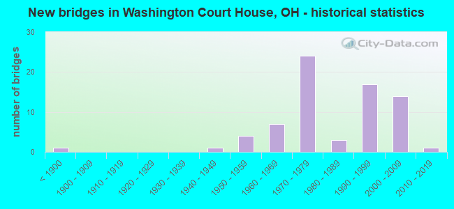
- New bridges - historical statistics
- 1Before 1900
- 11940-1949
- 41950-1959
- 71960-1969
- 241970-1979
- 31980-1989
- 171990-1999
- 142000-2009
- 12010-2019
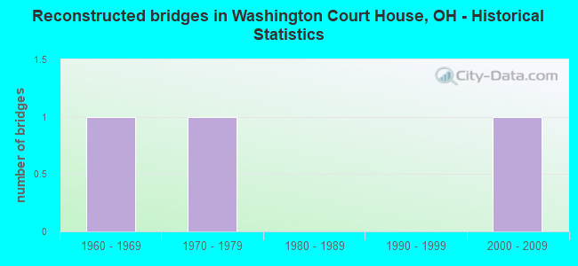
- Reconstructed bridges - Historical Statistics
- 11960-1969
- 11970-1979
- 01980-1989
- 01990-1999
- 12000-2009
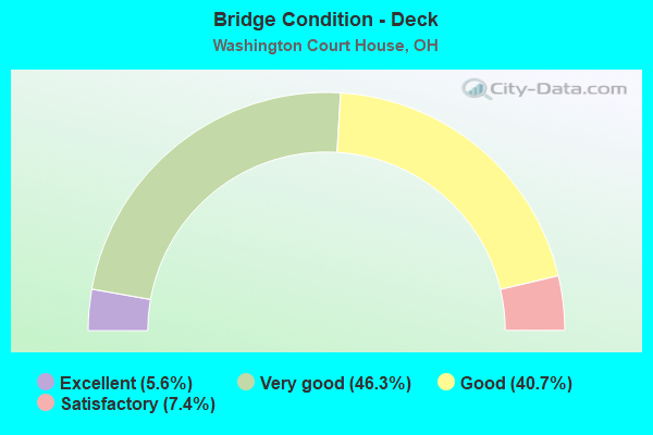
- Bridge Condition - Deck
- 5.6%Excellent
- 46.3%Very good
- 40.7%Good
- 7.4%Satisfactory
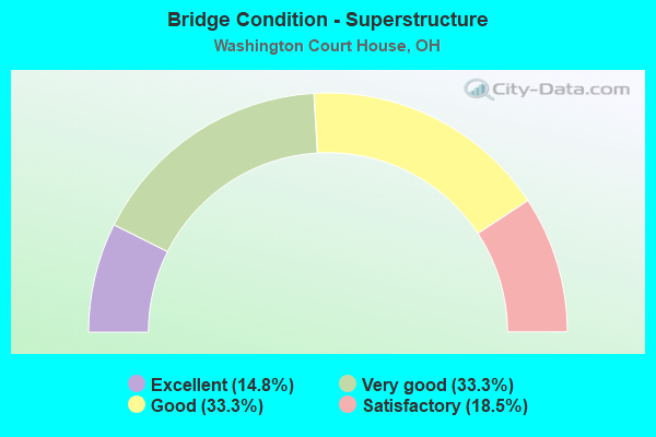
- Bridge Condition - Superstructure
- 14.8%Excellent
- 33.3%Very good
- 33.3%Good
- 18.5%Satisfactory
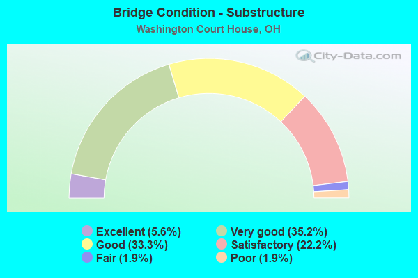
- Bridge Condition - Substructure
- 5.6%Excellent
- 35.2%Very good
- 33.3%Good
- 22.2%Satisfactory
- 1.9%Fair
- 1.9%Poor
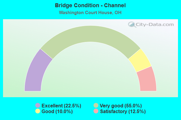
- Bridge Condition - Channel
- 22.5%Excellent
- 55.0%Very good
- 10.0%Good
- 12.5%Satisfactory
Find on map >> Show street view
Structure Number: 2430916, Location: 0.15 MI E USR 62 (Lat: 39.475911, Lng: -83.478431), Route carried "on" structure: County highway T0052, Year Built: 1969, Status: Open, Structure Length: 1.16m (3.81ft), Average Daily Traffic: 109 (year 2015), Truck Traffic: 7%, Average Future Daily Traffic: 151 (year 2035), Design Load: HS 20, Features Intersected: HANKINSRUN STAUNTONSUGAR, Facility Carried by Structure: STAUNTON SUGAR GRV
Minimum Vertical Clearance: 30+ m (98+ ft), Kilometerpoint: 0.241, Lanes on structure: 2, Owner: County Highway Agency, Approaching Roadway Width: 8.5m (27.9ft), Skew: 1 degrees, Material/Design: Prestressed concrete, Design/Construction: Box Beam or Girders - Multiple, Number Of Spans In Main Unit: 1, Length of Maximum Span: 10.4m (34.1ft), Curb-To-Curb Width: 8.5m (27.9ft), Out-to-Out Width: 8.5m (27.9ft)
Condition: Deck: Good, Superstructure: Satisfactory, Substructure: Good, Channel: Good, Operating Rating: 40.8 metric tons, Method Used To Determine Operating Rating: Field evaluation and documented engineering judgment, Inventory Rating: 32.7 metric tons, Method Used To Determine Inventory Rating: Field evaluation and documented engineering judgment, Structural Evaluation: Equal to present minimum criteria, Deck Geometry: Equal to present minimum criteria, Waterway Adequacy: Superior to present desirable criteria, Approach Roadway Alignment: Equal to present minimum criteria, Designated Inspection Frequency: Every 12 months, Inspection Date: July 2021, Deck Structure Type: Concrete Cast-file-Place, Wearing Surface/Protective System: Wearing Surface: Bituminous
Find on map >> Show street view
Structure Number: 2430959, Location: 0.3 MI E USR 62S (Lat: 39.486939, Lng: -83.472889), Route carried "on" structure: County highway T0054, Year Built: 1883, Year Reconstructed: 1971, Status: Posted for load, Structure Length: 3.23m (10.60ft), Average Daily Traffic: 351 (year 2015), Truck Traffic: 7%, Average Future Daily Traffic: 487 (year 2035), Design Load: HS 20, Features Intersected: SUGAR CREEK MARK RD, Facility Carried by Structure: MARK ROAD-TR54
Minimum Vertical Clearance: 4.27m (14.01ft), Kilometerpoint: 2.414, Lanes on structure: 1, Owner: County Highway Agency, Approaching Roadway Width: 6.1m (20.0ft), Material/Design: Steel, Design/Construction: Truss - Thru, Number Of Spans In Main Unit: 1, Length of Maximum Span: 32.3m (106.0ft), Curb-To-Curb Width: 4.1m (13.5ft), Out-to-Out Width: 4.3m (14.1ft)
Condition: Deck: Good, Superstructure: Satisfactory, Substructure: Good, Channel: Satisfactory, Operating Rating: 19.4 metric tons, Method Used To Determine Operating Rating: Load Factor (LF) rating reported by rating factor (RF) method using MS18 loading, Inventory Rating: 13.0 metric tons, Method Used To Determine Inventory Rating: Load Factor (LF) rating reported by rating factor (RF) method using MS18 loading, Structural Evaluation: Meets minimum limits, Deck Geometry: High priority of replacement, Waterway Adequacy: Superior to present desirable criteria, Approach Roadway Alignment: Equal to present minimum criteria, Bridge Posting: Required (Relationship of Operating Rating to Maximum Legal Load: > 39.9% below), Length Of Structure Improvement: 3.29m (10.79ft), Designated Inspection Frequency: Every 12 months, Critical Feature Inspection Frequency: Every 24 months, Inspection Date: July 2021, Critical Feature Inspection Date: June 2020, Roadway Improvement Cost: $10,000, Total Project Cost: $105,000, Deck Structure Type: Other, Wearing Surface/Protective System: Wearing Surface: Bituminous
Find on map >> Show street view
Structure Number: 2431041, Location: 1.3 MI S USR 35 (Lat: 39.493350, Lng: -83.416550), Route carried "on" structure: County highway C0058, Year Built: 1958, Status: Open, Structure Length: 1.10m (3.61ft), Average Daily Traffic: 271 (year 2015), Truck Traffic: 7%, Average Future Daily Traffic: 376 (year 2035), Design Load: HS 20, Features Intersected: PONE CR - CREEK RD, Facility Carried by Structure: CREEK ROAD-CR58
Minimum Vertical Clearance: 30+ m (98+ ft), Kilometerpoint: 6.598, Lanes on structure: 2, Owner: County Highway Agency, Approaching Roadway Width: 7.9m (25.9ft), Skew: 2 degrees, Material/Design: Concrete, Design/Construction: Slab, Number Of Spans In Main Unit: 1, Length of Maximum Span: 11.0m (36.1ft), Curb-To-Curb Width: 5.5m (18.0ft), Out-to-Out Width: 7.3m (24.0ft)
Condition: Deck: Good, Superstructure: Good, Substructure: Satisfactory, Channel: Very good, Operating Rating: 40.8 metric tons, Method Used To Determine Operating Rating: Field evaluation and documented engineering judgment, Inventory Rating: 32.7 metric tons, Method Used To Determine Inventory Rating: Field evaluation and documented engineering judgment, Structural Evaluation: Equal to present minimum criteria, Deck Geometry: High priority of corrective action, Waterway Adequacy: Superior to present desirable criteria, Approach Roadway Alignment: Equal to present minimum criteria, Designated Inspection Frequency: Every 12 months, Inspection Date: July 2021, Deck Structure Type: Concrete Cast-file-Place, Wearing Surface/Protective System: Wearing Surface: Bituminous
Find on map >> Show street view
Structure Number: 2431068, Location: 0.1 MI N USR 35 (Lat: 39.513731, Lng: -83.418539), Route carried "on" structure: County highway C0058, Year Built: 1964, Status: Open, Structure Length: 1.19m (3.90ft), Average Daily Traffic: 120 (year 2018), Truck Traffic: 5%, Average Future Daily Traffic: 167 (year 2038), Design Load: HS 20, Features Intersected: MCLEAN DITCH-CREEK RD, Facility Carried by Structure: CREEK ROAD-CR 58
Minimum Vertical Clearance: 30+ m (98+ ft), Kilometerpoint: 9.012, Lanes on structure: 2, Owner: County Highway Agency, Approaching Roadway Width: 14.9m (48.9ft), Skew: 3 degrees, Material/Design: Prestressed concrete, Design/Construction: Box Beam or Girders - Multiple, Number Of Spans In Main Unit: 1, Length of Maximum Span: 11.9m (39.0ft), Curb-To-Curb Width: 5.5m (18.0ft), Out-to-Out Width: 7.6m (24.9ft)
Condition: Deck: Good, Superstructure: Good, Substructure: Very good, Channel: Good, Operating Rating: 40.8 metric tons, Method Used To Determine Operating Rating: Field evaluation and documented engineering judgment, Inventory Rating: 32.7 metric tons, Method Used To Determine Inventory Rating: Field evaluation and documented engineering judgment, Structural Evaluation: Better than present minimum criteria, Deck Geometry: High priority of corrective action, Waterway Adequacy: Superior to present desirable criteria, Approach Roadway Alignment: Equal to present minimum criteria, Designated Inspection Frequency: Every 24 months, Inspection Date: March 2021, Deck Structure Type: Concrete Cast-file-Place, Wearing Surface/Protective System: Wearing Surface: Bituminous
Find on map >> Show street view
Structure Number: 2431866, Location: 0.4 MI NW USR 22 (Lat: 39.551489, Lng: -83.342161), Route carried "on" structure: County highway C0137, Year Built: 1959, Year Reconstructed: 1970, Status: Open, Structure Length: 1.49m (4.89ft), Average Daily Traffic: 430 (year 2015), Truck Traffic: 7%, Average Future Daily Traffic: 597 (year 2035), Design Load: HS 20, Features Intersected: BR NF COMPTON-O SPRINGFL, Facility Carried by Structure: OLD SPR RD- CR 137
Minimum Vertical Clearance: 30+ m (98+ ft), Kilometerpoint: 0.644, Lanes on structure: 2, Owner: County Highway Agency, Approaching Roadway Width: 8.5m (27.9ft), Material/Design: Concrete, Design/Construction: Tee Beam, Number Of Spans In Main Unit: 1, Length of Maximum Span: 14.9m (48.9ft), Curb-To-Curb Width: 6.7m (22.0ft), Out-to-Out Width: 8.5m (27.9ft)
Condition: Deck: Good, Superstructure: Good, Substructure: Fair, Channel: Very good, Operating Rating: 42.1 metric tons, Method Used To Determine Operating Rating: Load Factor (LF) rating reported by rating factor (RF) method using MS18 loading, Inventory Rating: 32.4 metric tons, Method Used To Determine Inventory Rating: Load Factor (LF) rating reported by rating factor (RF) method using MS18 loading, Structural Evaluation: Somewhat better than minimum adequacy, Deck Geometry: Meets minimum limits, Waterway Adequacy: Superior to present desirable criteria, Approach Roadway Alignment: Equal to present minimum criteria, Designated Inspection Frequency: Every 12 months, Inspection Date: March 2021, Deck Structure Type: Concrete Cast-file-Place, Wearing Surface/Protective System: Wearing Surface: Bituminous
Find on map >> Show street view
Structure Number: 243189, Location: 0.2 MI S USR 35 (Lat: 39.514231, Lng: -83.377461), Route carried "on" structure: County highway C0138, Year Built: 1959, Status: Open, Structure Length: 0.73m (2.40ft), Average Daily Traffic: 335 (year 2018), Truck Traffic: 7%, Average Future Daily Traffic: 465 (year 2038), Design Load: HS 20, Features Intersected: GROVE DITCH - BOGUS ROAD, Facility Carried by Structure: BOGUS ROAD-CR138
Minimum Vertical Clearance: 30+ m (98+ ft), Kilometerpoint: 3.701, Lanes on structure: 2, Owner: County Highway Agency, Approaching Roadway Width: 7.3m (24.0ft), Material/Design: Concrete, Design/Construction: Slab, Number Of Spans In Main Unit: 1, Length of Maximum Span: 7.3m (24.0ft), Curb-To-Curb Width: 7.3m (24.0ft), Out-to-Out Width: 7.3m (24.0ft)
Condition: Deck: Satisfactory, Superstructure: Satisfactory, Substructure: Good, Channel: Very good, Operating Rating: 40.8 metric tons, Method Used To Determine Operating Rating: Field evaluation and documented engineering judgment, Inventory Rating: 32.7 metric tons, Method Used To Determine Inventory Rating: Field evaluation and documented engineering judgment, Structural Evaluation: Equal to present minimum criteria, Deck Geometry: Somewhat better than minimum adequacy, Waterway Adequacy: Better than present minimum criteria, Approach Roadway Alignment: Equal to present desirable criteria, Designated Inspection Frequency: Every 12 months, Inspection Date: April 2021, Deck Structure Type: Concrete Cast-file-Place, Wearing Surface/Protective System: Wearing Surface: Bituminous
Find on map >> Show street view
Structure Number: 2431939, Location: 0.9 MI W SR 753 (Lat: 39.529650, Lng: -83.416039), Route carried "on" structure: County highway C0141, Year Built: 1973, Status: Open, Structure Length: 4.66m (15.29ft), Average Daily Traffic: 2,327 (year 2015), Truck Traffic: 7%, Average Future Daily Traffic: 3,230 (year 2035), Design Load: HS 20, Features Intersected: MAIN PAINT CK-ROBINSON R, Facility Carried by Structure: ROBINSON RD-CR 141
Minimum Vertical Clearance: 30+ m (98+ ft), Kilometerpoint: 0.885, Lanes on structure: 2, Owner: County Highway Agency, Approaching Roadway Width: 8.2m (26.9ft), Material/Design: Prestressed concrete, Design/Construction: Box Beam or Girders - Multiple, Number Of Spans In Main Unit: 3, Length of Maximum Span: 15.5m (50.9ft), Curb-To-Curb Width: 12.3m (40.4ft), Out-to-Out Width: 12.3m (40.4ft)
Condition: Deck: Good, Superstructure: Good, Substructure: Poor, Channel: Very good, Operating Rating: 42.1 metric tons, Method Used To Determine Operating Rating: Load Factor (LF) rating reported by rating factor (RF) method using MS18 loading, Inventory Rating: 32.4 metric tons, Method Used To Determine Inventory Rating: Load Factor (LF) rating reported by rating factor (RF) method using MS18 loading, Structural Evaluation: Meets minimum limits, Deck Geometry: Equal to present minimum criteria, Waterway Adequacy: Superior to present desirable criteria, Approach Roadway Alignment: Superior to present desirable criteria, Designated Inspection Frequency: Every 12 months, Inspection Date: July 2021, Deck Structure Type: Concrete Cast-file-Place, Wearing Surface/Protective System: Wearing Surface: Bituminous, Membrane: Preformed Fabric
Find on map >> Show street view
Structure Number: 2431963, Location: 0.5 MI N USR 35 (Lat: 39.512131, Lng: -83.337781), Route carried "on" structure: County highway C0141, Year Built: 1966, Status: Open, Structure Length: 1.34m (4.40ft), Average Daily Traffic: 340 (year 2015), Truck Traffic: 7%, Average Future Daily Traffic: 472 (year 2035), Design Load: HS 20, Features Intersected: CROOKED CK - ROBINSON RD, Facility Carried by Structure: ROBINSON RD-CR 141
Minimum Vertical Clearance: 30+ m (98+ ft), Kilometerpoint: 8.369, Lanes on structure: 2, Owner: County Highway Agency, Approaching Roadway Width: 6.7m (22.0ft), Material/Design: Prestressed concrete, Design/Construction: Box Beam or Girders - Multiple, Number Of Spans In Main Unit: 1, Length of Maximum Span: 13.4m (44.0ft), Curb-To-Curb Width: 7.4m (24.3ft), Out-to-Out Width: 7.4m (24.3ft)
Condition: Deck: Very good, Superstructure: Satisfactory, Substructure: Satisfactory, Channel: Good, Operating Rating: 40.8 metric tons, Method Used To Determine Operating Rating: Field evaluation and documented engineering judgment, Inventory Rating: 32.7 metric tons, Method Used To Determine Inventory Rating: Field evaluation and documented engineering judgment, Structural Evaluation: Equal to present minimum criteria, Deck Geometry: Somewhat better than minimum adequacy, Waterway Adequacy: Superior to present desirable criteria, Approach Roadway Alignment: Equal to present minimum criteria, Designated Inspection Frequency: Every 12 months, Inspection Date: March 2021, Deck Structure Type: Other, Wearing Surface/Protective System: Wearing Surface: Bituminous, Membrane: Epoxy
Find on map >> Show street view
Structure Number: 2432374, Location: 0.56 MI. N US 22 (Lat: 39.555111, Lng: -83.335281), Route carried "on" structure: County highway T0134, Year Built: 1996, Status: Open, Structure Length: 1.86m (6.10ft), Average Daily Traffic: 351 (year 2015), Truck Traffic: 7%, Average Future Daily Traffic: 487 (year 2035), Design Load: HS 20, Features Intersected: HESS RD. N FORK COMPTON, Facility Carried by Structure: HESS RD.-TR 134
Minimum Vertical Clearance: 30+ m (98+ ft), Kilometerpoint: 0.901, Lanes on structure: 2, Owner: County Highway Agency, Approaching Roadway Width: 4.9m (16.1ft), Material/Design: Prestressed concrete, Design/Construction: Box Beam or Girders - Multiple, Number Of Spans In Main Unit: 1, Length of Maximum Span: 17.7m (58.1ft), Curb-To-Curb Width: 7.3m (24.0ft), Out-to-Out Width: 7.3m (24.0ft)
Condition: Deck: Very good, Superstructure: Very good, Substructure: Very good, Channel: Very good, Operating Rating: 40.8 metric tons, Method Used To Determine Operating Rating: Field evaluation and documented engineering judgment, Inventory Rating: 32.7 metric tons, Method Used To Determine Inventory Rating: Field evaluation and documented engineering judgment, Structural Evaluation: Equal to present desirable criteria, Deck Geometry: Somewhat better than minimum adequacy, Waterway Adequacy: Superior to present desirable criteria, Approach Roadway Alignment: Equal to present minimum criteria, Designated Inspection Frequency: Every 24 months, Inspection Date: March 2021, Deck Structure Type: Concrete Cast-file-Place, Wearing Surface/Protective System: Wearing Surface: Bituminous, Membrane: Preformed Fabric
Find on map >> Show street view
Structure Number: 2432439, Location: 1.54 MI E OF SR753 (Lat: 39.509800, Lng: -83.382089), Route carried "on" structure: County highway C035A, Year Built: 1988, Status: Open, Structure Length: 1.13m (3.71ft), Average Daily Traffic: 541 (year 2015), Truck Traffic: 9%, Average Future Daily Traffic: 751 (year 2035), Design Load: HS 20, Features Intersected: OLD 35-SHEPARDS DITCH, Facility Carried by Structure: OLD 35
Minimum Vertical Clearance: 30+ m (98+ ft), Kilometerpoint: 29.966, Lanes on structure: 2, Owner: County Highway Agency, Approaching Roadway Width: 8.8m (28.9ft), Skew: 1 degrees, Material/Design: Prestressed concrete, Design/Construction: Box Beam or Girders - Multiple, Number Of Spans In Main Unit: 1, Length of Maximum Span: 11.3m (37.1ft), Curb-To-Curb Width: 8.8m (28.9ft), Out-to-Out Width: 10.1m (33.1ft)
Condition: Deck: Very good, Superstructure: Good, Substructure: Very good, Channel: Very good, Operating Rating: 40.8 metric tons, Method Used To Determine Operating Rating: Field evaluation and documented engineering judgment, Inventory Rating: 32.7 metric tons, Method Used To Determine Inventory Rating: Field evaluation and documented engineering judgment, Structural Evaluation: Better than present minimum criteria, Deck Geometry: Somewhat better than minimum adequacy, Waterway Adequacy: Superior to present desirable criteria, Approach Roadway Alignment: Equal to present minimum criteria, Designated Inspection Frequency: Every 24 months, Inspection Date: March 2021, Deck Structure Type: Concrete Cast-file-Place, Wearing Surface/Protective System: Wearing Surface: Bituminous, Membrane: Built-up
Find on map >> Show street view
Structure Number: 2432536, Location: 0.4 MI N USR 22W (Lat: 39.522781, Lng: -83.521189), Route carried "on" structure: County highway C0064, Year Built: 1976, Status: Open, Structure Length: 1.22m (4.00ft), Average Daily Traffic: 272 (year 2015), Truck Traffic: 7%, Average Future Daily Traffic: 378 (year 2035), Design Load: HS 20, Features Intersected: CAMP RUN JASPER COIL RD, Facility Carried by Structure: JASPER COILRD-CR64
Minimum Vertical Clearance: 30+ m (98+ ft), Kilometerpoint: 0.563, Lanes on structure: 2, Owner: County Highway Agency, Approaching Roadway Width: 9.1m (29.9ft), Skew: 3 degrees, Material/Design: Prestressed concrete, Design/Construction: Box Beam or Girders - Multiple, Number Of Spans In Main Unit: 1, Length of Maximum Span: 12.2m (40.0ft), Curb-To-Curb Width: 7.3m (24.0ft), Out-to-Out Width: 7.3m (24.0ft)
Condition: Deck: Good, Superstructure: Good, Substructure: Good, Channel: Satisfactory, Operating Rating: 40.8 metric tons, Method Used To Determine Operating Rating: Field evaluation and documented engineering judgment, Inventory Rating: 32.7 metric tons, Method Used To Determine Inventory Rating: Field evaluation and documented engineering judgment, Structural Evaluation: Better than present minimum criteria, Deck Geometry: Somewhat better than minimum adequacy, Waterway Adequacy: Superior to present desirable criteria, Approach Roadway Alignment: Equal to present minimum criteria, Designated Inspection Frequency: Every 24 months, Inspection Date: May 2021, Deck Structure Type: Concrete Cast-file-Place, Wearing Surface/Protective System: Wearing Surface: Bituminous
Find on map >> Show street view
Structure Number: 2432595, Location: 0.3 MI N USR 35 (Lat: 39.512069, Lng: -83.344131), Route carried "on" structure: County highway C0142, Year Built: 1977, Status: Open, Structure Length: 1.16m (3.81ft), Average Daily Traffic: 477 (year 2018), Truck Traffic: 8%, Average Future Daily Traffic: 662 (year 2038), Design Load: HS 20, Features Intersected: CROOKED CK- CAMP GROVE R, Facility Carried by Structure: CAMP GROVE -CR 142
Minimum Vertical Clearance: 30+ m (98+ ft), Kilometerpoint: 8.449, Lanes on structure: 2, Owner: County Highway Agency, Approaching Roadway Width: 8.5m (27.9ft), Material/Design: Prestressed concrete, Design/Construction: Stringer/Multi-beam, Number Of Spans In Main Unit: 1, Length of Maximum Span: 11.6m (38.1ft), Curb-To-Curb Width: 8.4m (27.6ft), Out-to-Out Width: 8.5m (27.9ft)
Condition: Deck: Very good, Superstructure: Very good, Substructure: Good, Channel: Very good, Operating Rating: 42.1 metric tons, Method Used To Determine Operating Rating: Load and Resistance Factor Rating (LRFR) rating reported by rating factor(RF) method using HL-93 loadings, Inventory Rating: 32.4 metric tons, Method Used To Determine Inventory Rating: Load and Resistance Factor Rating (LRFR) rating reported by rating factor(RF) method using HL-93 loadings, Structural Evaluation: Better than present minimum criteria, Deck Geometry: Somewhat better than minimum adequacy, Waterway Adequacy: Somewhat better than minimum adequacy, Approach Roadway Alignment: Equal to present minimum criteria, Designated Inspection Frequency: Every 24 months, Inspection Date: March 2021, Deck Structure Type: Concrete Cast-file-Place, Wearing Surface/Protective System: Wearing Surface: Bituminous
Find on map >> Show street view
Structure Number: 2432986, Location: .05 MI S FLAKES FORD-CR55 (Lat: 39.480381, Lng: -83.459161), Route carried "on" structure: County highway T0053, Year Built: 1989, Status: Open, Structure Length: 3.32m (10.89ft), Average Daily Traffic: 351 (year 2015), Truck Traffic: 7%, Average Future Daily Traffic: 487 (year 2035), Design Load: H 20, Features Intersected: SUGAR CR ARMBRUST RD, Facility Carried by Structure: ARMBRUST ROAD-TR53
Minimum Vertical Clearance: 30+ m (98+ ft), Kilometerpoint: 2.494, Lanes on structure: 2, Owner: County Highway Agency, Approaching Roadway Width: 9.8m (32.2ft), Skew: 1 degrees, Material/Design: Prestressed concrete, Design/Construction: Box Beam or Girders - Multiple, Number Of Spans In Main Unit: 3, Length of Maximum Span: 12.2m (40.0ft), Curb-To-Curb Width: 7.3m (24.0ft), Out-to-Out Width: 7.3m (24.0ft)
Condition: Deck: Very good, Superstructure: Very good, Substructure: Good, Channel: Very good, Operating Rating: 42.1 metric tons, Method Used To Determine Operating Rating: Load Factor (LF) rating reported by rating factor (RF) method using MS18 loading, Inventory Rating: 32.4 metric tons, Method Used To Determine Inventory Rating: Load Factor (LF) rating reported by rating factor (RF) method using MS18 loading, Structural Evaluation: Better than present minimum criteria, Deck Geometry: Somewhat better than minimum adequacy, Waterway Adequacy: Superior to present desirable criteria, Approach Roadway Alignment: Equal to present minimum criteria, Designated Inspection Frequency: Every 24 months, Inspection Date: July 2021, Deck Structure Type: Concrete Cast-file-Place, Wearing Surface/Protective System: Wearing Surface: Bituminous, Membrane: Preformed Fabric
Find on map >> Show street view
Structure Number: 2433087, Location: 0.2 MI. S. OF JCT TR57 (Lat: 39.500411, Lng: -83.453931), Route carried "on" structure: County highway T0053, Year Built: 1994, Status: Open, Structure Length: 0.82m (2.69ft), Average Daily Traffic: 324 (year 2015), Truck Traffic: 7%, Average Future Daily Traffic: 450 (year 2035), Design Load: H 20, Features Intersected: PONE CREEK ARMBUST RD, Facility Carried by Structure: ARMBRUST RD-TR 53
Minimum Vertical Clearance: 30+ m (98+ ft), Kilometerpoint: 4.828, Lanes on structure: 2, Owner: County Highway Agency, Approaching Roadway Width: 8.2m (26.9ft), Skew: 3 degrees, Material/Design: Concrete, Design/Construction: Frame, Number Of Spans In Main Unit: 1, Length of Maximum Span: 8.2m (26.9ft), Curb-To-Curb Width: 5.8m (19.0ft), Out-to-Out Width: 7.6m (24.9ft)
Condition: Deck: Very good, Superstructure: Very good, Substructure: Very good, Channel: Good, Operating Rating: 42.1 metric tons, Method Used To Determine Operating Rating: Load Factor (LF) rating reported by rating factor (RF) method using MS18 loading, Inventory Rating: 32.4 metric tons, Method Used To Determine Inventory Rating: Load Factor (LF) rating reported by rating factor (RF) method using MS18 loading, Structural Evaluation: Equal to present desirable criteria, Deck Geometry: High priority of corrective action, Waterway Adequacy: Superior to present desirable criteria, Approach Roadway Alignment: Equal to present minimum criteria, Designated Inspection Frequency: Every 24 months, Inspection Date: March 2021, Deck Structure Type: Concrete Cast-file-Place, Wearing Surface/Protective System: Wearing Surface: Bituminous, Membrane: Preformed Fabric
Find on map >> Show street view
Structure Number: 2433168, Location: 0.8 MI SOUTH USR 22 (Lat: 39.536189, Lng: -83.337539), Route carried "on" structure: County highway C0142, Year Built: 2005, Status: Open, Structure Length: 0.94m (3.08ft), Average Daily Traffic: 385 (year 2015), Truck Traffic: 8%, Average Future Daily Traffic: 534 (year 2035), Design Load: HS 25 or greater, Features Intersected: BLUE RUN, Facility Carried by Structure: CAMP GROVE- CR 142
Minimum Vertical Clearance: 30+ m (98+ ft), Kilometerpoint: 11.668, Lanes on structure: 2, Owner: County Highway Agency, Approaching Roadway Width: 8.5m (27.9ft), Material/Design: Prestressed concrete, Design/Construction: Box Beam or Girders - Multiple, Number Of Spans In Main Unit: 1, Length of Maximum Span: 9.4m (30.8ft), Curb-To-Curb Width: 8.5m (27.9ft), Out-to-Out Width: 8.5m (27.9ft)
Condition: Deck: Very good, Superstructure: Very good, Substructure: Very good, Channel: Excellent, Operating Rating: 42.1 metric tons, Method Used To Determine Operating Rating: Load Factor (LF) rating reported by rating factor (RF) method using MS18 loading, Inventory Rating: 32.4 metric tons, Method Used To Determine Inventory Rating: Load Factor (LF) rating reported by rating factor (RF) method using MS18 loading, Structural Evaluation: Equal to present desirable criteria, Deck Geometry: Equal to present minimum criteria, Waterway Adequacy: Equal to present desirable criteria, Approach Roadway Alignment: Equal to present minimum criteria, Designated Inspection Frequency: Every 24 months, Inspection Date: March 2021, Deck Structure Type: Concrete Cast-file-Place, Wearing Surface/Protective System: Wearing Surface: Bituminous, Membrane: Preformed Fabric
Find on map >> Show street view
Structure Number: 2433303, Location: 1.5 MILE EAST SR 41N (Lat: 39.577381, Lng: -83.446311), Route carried "on" structure: County highway C0027, Year Built: 2007, Status: Open, Structure Length: 0.91m (2.99ft), Average Daily Traffic: 1,032 (year 2015), Truck Traffic: 7%, Average Future Daily Traffic: 1,432 (year 2035), Design Load: H 20, Features Intersected: BIG RUN, Facility Carried by Structure: BLMBG-NH RD-CR 27
Minimum Vertical Clearance: 30+ m (98+ ft), Kilometerpoint: 6.196, Lanes on structure: 2, Owner: County Highway Agency, Approaching Roadway Width: 6.7m (22.0ft), Material/Design: Concrete, Design/Construction: Culvert, Number Of Spans In Main Unit: 1, Length of Maximum Span: 8.5m (27.9ft)
Condition: Channel: Excellent, Culverts: Excellent, Operating Rating: 42.1 metric tons, Method Used To Determine Operating Rating: Load Factor (LF) rating reported by rating factor (RF) method using MS18 loading, Inventory Rating: 32.4 metric tons, Method Used To Determine Inventory Rating: Load Factor (LF) rating reported by rating factor (RF) method using MS18 loading, Structural Evaluation: Equal to present desirable criteria, Waterway Adequacy: Superior to present desirable criteria, Approach Roadway Alignment: Superior to present desirable criteria, Designated Inspection Frequency: Every 24 months, Inspection Date: March 2021
Find on map >> Show street view
Structure Number: 2433486, Location: 0.3 MI N SR 38 (Lat: 39.561200, Lng: -83.437039), Route carried "on" structure: County highway C0028, Year Built: 2010, Status: Open, Structure Length: 1.17m (3.84ft), Average Daily Traffic: 687 (year 2015), Truck Traffic: 7%, Average Future Daily Traffic: 954 (year 2035), Design Load: H 20, Features Intersected: BIG RUN, Facility Carried by Structure: LEWIS ROAD (CR28)
Minimum Vertical Clearance: 30+ m (98+ ft), Kilometerpoint: 0.483, Lanes on structure: 2, Owner: County Highway Agency, Approaching Roadway Width: 11.0m (36.1ft), Material/Design: Concrete, Design/Construction: Culvert, Number Of Spans In Main Unit: 1, Length of Maximum Span: 11.0m (36.1ft)
Condition: Channel: Excellent, Culverts: Excellent, Operating Rating: 42.1 metric tons, Method Used To Determine Operating Rating: Load Factor (LF) rating reported by rating factor (RF) method using MS18 loading, Inventory Rating: 32.4 metric tons, Method Used To Determine Inventory Rating: Load Factor (LF) rating reported by rating factor (RF) method using MS18 loading, Structural Evaluation: Equal to present desirable criteria, Waterway Adequacy: Superior to present desirable criteria, Approach Roadway Alignment: Equal to present desirable criteria, Designated Inspection Frequency: Every 24 months, Inspection Date: March 2021
Find on map >> Show street view
Structure Number: 2400472, Location: 0.52 MI W OF US22 (Lat: 39.534869, Lng: -83.470600), Route carried "under" structure: US 35, Year Built: 1973, Structure Length: 0. m, Average Daily Traffic: 14,776 (year 2017), Truck Traffic: 33%, Features Intersected: UNDER JAMISON RD, Facility Carried by Structure: JAMISON RD
Minimum Vertical Clearance: 4.67m (15.32ft), Kilometerpoint: 21.298, Lanes on structure: 2, Lanes under structure: 4, Material/Design: Steel continuous, Design/Construction: Stringer/Multi-beam, Length of Maximum Span: 25.6m (84.0ft)
Find on map >> Show street view
Structure Number: 2400499, Location: 0.43 MI W OF US62 (Lat: 39.528639, Lng: -83.465250), Route carried "under" structure: US 22, Year Built: 1973, Structure Length: 0. m, Average Daily Traffic: 7,895 (year 2015), Truck Traffic: 7%, Features Intersected: UNDER USR 35, Facility Carried by Structure: US 35
Minimum Vertical Clearance: 4.80m (15.75ft), Kilometerpoint: 10.573, Lanes on structure: 2, Lanes under structure: 4, Material/Design: Concrete continuous, Design/Construction: Slab, Length of Maximum Span: 16.0m (52.5ft)
Find on map >> Show street view
Structure Number: 2400502, Location: 0.43 MI W OF US62 (Lat: 39.528581, Lng: -83.465581), Route carried "under" structure: US 22, Year Built: 1973, Structure Length: 0. m, Average Daily Traffic: 7,895 (year 2015), Truck Traffic: 7%, Features Intersected: UNDER USR 35, Facility Carried by Structure: US 35
Minimum Vertical Clearance: 5.11m (16.77ft), Kilometerpoint: 10.541, Lanes on structure: 2, Lanes under structure: 4, Material/Design: Concrete continuous, Design/Construction: Slab, Length of Maximum Span: 16.0m (52.5ft)
Find on map >> Show street view
Structure Number: 240051, Location: OVER CR 138 BOGUS RD(LT) (Lat: 39.516911, Lng: -83.377719), Route carried "under" structure: County highway 138, Year Built: 1998, Structure Length: 0. m, Average Daily Traffic: 335 (year 2015), Truck Traffic: 7%, Features Intersected: UNDER US35, Facility Carried by Structure: US 35
Minimum Vertical Clearance: 4.65m (15.26ft), Kilometerpoint: 5.633, Lanes on structure: 2, Lanes under structure: 2, Material/Design: Concrete continuous, Design/Construction: Slab, Length of Maximum Span: 12.2m (40.0ft)
Find on map >> Show street view
Structure Number: 2400529, Location: OVER BOGUS RD (CR 135)RT (Lat: 39.516681, Lng: -83.377711), Route carried "under" structure: County highway 138, Year Built: 1998, Structure Length: 0. m, Average Daily Traffic: 335 (year 2015), Truck Traffic: 7%, Features Intersected: UNDER SR 35, Facility Carried by Structure: US 35 RT
Minimum Vertical Clearance: 4.52m (14.83ft), Kilometerpoint: 0.000, Lanes on structure: 2, Lanes under structure: 2, Material/Design: Concrete continuous, Design/Construction: Slab, Length of Maximum Span: 12.2m (40.0ft)
Find on map >> Show street view
Structure Number: 2400553, Location: 1.3 MI E OF SR41 (Lat: 39.512819, Lng: -83.418631), Route carried "under" structure: County highway 58, Year Built: 1973, Structure Length: 0. m, Average Daily Traffic: 120 (year 2015), Truck Traffic: 5%, Features Intersected: US 35, Facility Carried by Structure: US 35
Minimum Vertical Clearance: 4.39m (14.40ft), Kilometerpoint: 0.000, Lanes on structure: 2, Lanes under structure: 2, Material/Design: Steel continuous, Design/Construction: Stringer/Multi-beam, Length of Maximum Span: 31.7m (104.0ft)
Find on map >> Show street view
Structure Number: 2400561, Location: 1.3 MI E OF SR41 (Lat: 39.512581, Lng: -83.418600), Route carried "under" structure: County highway 58, Year Built: 1973, Structure Length: 0. m, Average Daily Traffic: 120 (year 2015), Truck Traffic: 5%, Features Intersected: US 35, Facility Carried by Structure: US 35
Minimum Vertical Clearance: 4.40m (14.44ft), Kilometerpoint: 0.000, Lanes on structure: 2, Lanes under structure: 2, Material/Design: Steel continuous, Design/Construction: Stringer/Multi-beam, Length of Maximum Span: 30.8m (101.0ft)
Find on map >> Show street view
Structure Number: 2400588, Location: 3.4 MI E OF SR-753 (Lat: 39.507500, Lng: -83.346750), Route carried "under" structure: US 35, Year Built: 1998, Structure Length: 0. m, Average Daily Traffic: 12,198 (year 2017), Truck Traffic: 31%, Features Intersected: CR-142 CAMP GROVE RD, Facility Carried by Structure: CR 142 CAMP GROVE
Minimum Vertical Clearance: 5.21m (17.09ft), Kilometerpoint: 33.249, Lanes on structure: 2, Lanes under structure: 4, Material/Design: Steel continuous, Design/Construction: Stringer/Multi-beam, Length of Maximum Span: 36.9m (121.1ft)
Find on map >> Show street view
Structure Number: 2400642, Location: AT SR753 (Lat: 39.513900, Lng: -83.408339), Route carried "under" structure: State highway 753, Year Built: 1972, Structure Length: 0. m, Average Daily Traffic: 5,677 (year 2015), Truck Traffic: 16%, Features Intersected: US-35, Facility Carried by Structure: US 35
Minimum Vertical Clearance: 4.78m (15.68ft), Kilometerpoint: 17.397, Lanes on structure: 2, Lanes under structure: 4, Material/Design: Concrete continuous, Design/Construction: Slab, Length of Maximum Span: 13.4m (44.0ft)
Find on map >> Show street view
Structure Number: 240065, Location: AT SR753 (Lat: 39.513661, Lng: -83.408381), Route carried "under" structure: State highway 753, Year Built: 1972, Structure Length: 0. m, Average Daily Traffic: 5,677 (year 2015), Truck Traffic: 16%, Features Intersected: US-35, Facility Carried by Structure: US 35
Minimum Vertical Clearance: 4.65m (15.26ft), Kilometerpoint: 17.349, Lanes on structure: 2, Lanes under structure: 4, Material/Design: Concrete continuous, Design/Construction: Slab, Length of Maximum Span: 14.5m (47.6ft)
Find on map >> Show street view
Structure Number: 240079, Location: 1.29 MI WEST OF PALMER RD (Lat: 39.569400, Lng: -83.524000), Route carried "under" structure: County highway 12, Year Built: 2003, Structure Length: 0. m, Average Daily Traffic: 477 (year 2015), Truck Traffic: 8%, Features Intersected: UNDER NEW US35, Facility Carried by Structure: NEW US 35
Minimum Vertical Clearance: 4.85m (15.91ft), Kilometerpoint: 0.000, Lanes on structure: 2, Lanes under structure: 2, Material/Design: Prestressed concrete, Design/Construction: Stringer/Multi-beam, Length of Maximum Span: 39.3m (128.9ft)
Find on map >> Show street view
Structure Number: 2400839, Location: 1.29 MI EAST OF BUSH RD. (Lat: 39.549869, Lng: -83.487950), Route carried "under" structure: County highway 11, Year Built: 2003, Structure Length: 0. m, Average Daily Traffic: 579 (year 2015), Truck Traffic: 7%, Features Intersected: UNDER NEW US 35, Facility Carried by Structure: NEW US 35
Minimum Vertical Clearance: 4.75m (15.58ft), Kilometerpoint: 0.000, Lanes on structure: 2, Lanes under structure: 2, Material/Design: Prestressed concrete, Design/Construction: Stringer/Multi-beam, Length of Maximum Span: 22.6m (74.1ft)
Find on map >> Show street view
Structure Number: 2400863, Location: 1.09 MI. EAST OF FORD RD (Lat: 39.560631, Lng: -83.508111), Route carried "under" structure: US 35, Year Built: 2003, Structure Length: 0. m, Average Daily Traffic: 14,090 (year 2017), Truck Traffic: 35%, Features Intersected: UNDER TR-66 BUSH ROAD, Facility Carried by Structure: BUSH ROAD TR-66
Minimum Vertical Clearance: 5.11m (16.77ft), Kilometerpoint: 16.995, Lanes on structure: 2, Lanes under structure: 4, Material/Design: Prestressed concrete, Design/Construction: Stringer/Multi-beam, Length of Maximum Span: 37.7m (123.7ft)
Find on map >> Show street view
Structure Number: 2400898, Location: 1.29 MI EAST OF BUSH RD. (Lat: 39.549711, Lng: -83.488169), Route carried "under" structure: County highway 11, Year Built: 2003, Structure Length: 0. m, Average Daily Traffic: 579 (year 2015), Truck Traffic: 7%, Features Intersected: UNDER NEW US 35, Facility Carried by Structure: NEW US 35
Minimum Vertical Clearance: 4.62m (15.16ft), Kilometerpoint: 0.000, Lanes on structure: 2, Lanes under structure: 2, Material/Design: Prestressed concrete, Design/Construction: Stringer/Multi-beam, Length of Maximum Span: 22.6m (74.1ft)
Find on map >> Show street view
Structure Number: 2400928, Location: 1.29 MI WEST OF PALMER RD (Lat: 39.569389, Lng: -83.523611), Route carried "under" structure: County highway 12, Year Built: 2003, Structure Length: 0. m, Average Daily Traffic: 477 (year 2015), Truck Traffic: 8%, Features Intersected: UNDER NEW US 35, Facility Carried by Structure: NEW US 35
Minimum Vertical Clearance: 4.90m (16.08ft), Kilometerpoint: 0.000, Lanes on structure: 2, Lanes under structure: 2, Material/Design: Prestressed concrete, Design/Construction: Stringer/Multi-beam, Length of Maximum Span: 39.3m (128.9ft)
Find on map >> Show street view
Structure Number: 2401037, Location: 1.3 MI S OF US22 (Lat: 39.514631, Lng: -83.442689), Route carried "under" structure: US 35, Year Built: 1973, Structure Length: 0. m, Average Daily Traffic: 13,361 (year 2015), Truck Traffic: 35%, Features Intersected: UNDER SR 41, Facility Carried by Structure: SR 41
Minimum Vertical Clearance: 4.80m (15.75ft), Kilometerpoint: 24.736, Lanes on structure: 4, Lanes under structure: 4, Material/Design: Steel continuous, Design/Construction: Stringer/Multi-beam, Length of Maximum Span: 22.6m (74.1ft)